1. Introduction
Urban development induces increases in impervious surfaces and related sewer infrastructures altering the hydrological dynamics (peak, pathways and time of runoff) and enhancing the flooding risks [
1,
2], at different scales [
3,
4,
5].
Altered urban soils (inadequate urban planning, infrastructure limitations, population growth, and resource mismanagement) do not take into account the natural water cycle and can obstruct the infiltration processes resulting in increased runoff or urban flooding [
6,
7].
The combination of natural phenomena resulting from global climate change evolution, which produces increases in the intensity and frequency of maximum rainfall [
8,
9,
10,
11,
12,
13] and the expansion of urban areas which affects land uses (enlarge impervious surfaces) and reduces the runoff lag times [
18,
19], impact significantly on vulnerability and exposure of urbanized areas, which are increasingly subjected to flooding phenomena [
14,
15,
16,
17,
18,
19].
Also in urban areas provided with modern drainage infrastructures, storm waters are carefully considered [
3,
24,
25] because of their potential impacts on the citizen’s life and human activities and the efficiency of the drainage networks are analyzed.
Investigating urban storm management allows us to analyze climate change impact on rainfall characteristics, the consequences of urban flooding risk and water quality deterioration, and the related possible mitigation and adaptation strategies.
In fact, even if drainage systems are essential to intercept and collect runoff outside, they cannot guarantee the total safety of the areas served. Only proactive and preventive interventions that adopt widespread solutions that act on the causes of outflows can have a positive impact on overall sustainability. Sustainable Urban Drainage (SUD) policies must be implemented at various stages [
26,
27] and at a range of spatial scales considering together the complex equilibrium between air-water-soil-vegetation and urban needs.
Despite the benefits of these systems being widely known and a lot of experimental and numerical investigations have been carried out these techniques are not yet widespread in urban planning implementation activities probably because they are strongly influenced by economic constraints and local regulations that differ from each other.
The SUD planning effectiveness should be improved by introducing innovative approaches to provide useful tools capable of supporting the planning decision processes.
Sustainable management practices and increasingly water-sensitive urban design strategies must be implemented to reduce the impacts of pluvial events in urban areas while helping in the creation of areas that encourage the development of a new urban and biodiverse ecosystem.
Several studies have been interested in the different aspects mentioned previously, developing synthetic approaches or complete models. Greater attention was paid to identifying risk areas [
30], influencing factors [
31,
32], flood susceptibility prediction [
33,
34,
35,
36], risk assessment [37; 38] and preventive management [
39,
40].
Most cities are characterized by an urban centre, which usually corresponds to the historic nucleus [
41], characterized by dense buildings with reduced roads and accessibility, contiguous to the areas of subsequent expansion which have transformed the original natural context to create new settlements, infrastructures and services.
These transformations occur in phases that follow one another over time, integrating different moments of planning that alter the morphology of the places and reduce the permeability of the surfaces, without paying particular attention to the interactions resulting from the changed territorial equilibrium between the urbanizations of different eras. Furthermore, the historical city centre represent the most delicate and precious component, but they are also exposed to direct and indirect actions which increase their vulnerability and exposure to the risks induced by climate changes.
Urban flooding strongly depends [
42,
43] on the morphology of the places, their physical characteristics and the transformations that have been implemented (land uses, infrastructures) [
44], as well as on the variability of climatic conditions.
Themes related to water are now widely present in the assessments conducted by many international organizations which, working at different scales, have adopted methodologies for calculating synthetic environmental indicators that consider the water resource in all its forms (risk, safeguard, employment) [
45,
46,
47,
48,
49,
50].
To describe the behavior of urbanized areas is often used the term Urban Metabolism coined for the first time by Abel Wolman [
51] in the mid-sixties, in an analogy between the functioning of a territory and that of a living organism - which to live it needs to feed on raw materials, process them through metabolic processes, and subsequently eliminate their waste and return to the scientific debate in recent decades thanks to the renewed interest of public opinion in environmental issues. The theory of urban metabolism has therefore evolved over the years expanding the use of environmental and social indicators, in order to also include all those infrastructures serving the city that lie beyond its perimeter.
The present paper, inspired by the theory of Urban Metabolism [
52], proposes a methodology that analyzes urban contexts through the description by basin, allowing to understand the relationships between the morphology of the territories, their characteristics and the transformations that have been implemented, together with the effects determined in terms of hydrological response and surface runoff.
The urban watershed partition identifies independent areas where the rainfall-runoff processes develop, overcoming the urban districts limits and remarking the natural interaction between the morphological parts of the basin (upper, medium, lower) which contribute together to the hydromorphic [
53] natural dynamic (intercept, transport, receive). The methodology applied to the case study of the city of Matera in Basilicata (Italy) which has a fairly articulated and complex morphology, even if it extends over a limited area, it consents to evaluate the response relating to each area of the urban context, in different scenarios.
In this sense, the case study considered in this work is particularly representative and describes the evolution of a part of the city of Matera which includes the historical nucleus of Sasso Caveoso and extends up to the top of the natural hill behind it. In this area, profound urban developments have occurred which have led to significant changes in the morphology and physical characteristics of the places which today appear almost entirely urbanized.
The sustainability of the transformations carried out can be assessed by describing how the different scenarios react to the natural climatic phenomena. In particular, considering the effects induced by rainfall and the resulting surface runoff on the urban efficiency.
2. Materials and Methods
In natural territories, the runoffs result from rainfall events (climate conditions) and strictly depend on the layout morphology (shape, extension, slope,..),the permeability of the soil and on the characteristics of the hydrographic network that convey the flows towards the basin outlet. Likewise, in urban areas, runoff flows rely on the morphology of the urban spaces (buildings, streets, squares, green areas,..)and on the layers’ permeability (pervious, impervious, green, land uses). Therefore, by examining the urban runoff it is possible to understand how efficient are the urban layouts and where probably stormy flows or flooded zones could occur that worsen the local risk conditions.
The hydromorphic complexities related to the transformation processes that involve urban and territorial areas should be analyzed in different moments of the urban evolution, in order to understand the effects of changes introduced over time or relating to future planning hypotheses.
The urban context could be analyzed by describing the watershed that compose the whole area [
1], where the original natural landscapes are substituted with the patterns generated by urban development, altering the calculations for surface runoff in various conditions and enabling the measurement of the impacts of any alterations.
The physical transformations of a natural watershed made by the urbanization processes could modify the shape or the permeability (areal changes), revise the flow pathways inside the basin (linear changes), or locally intercept or divert runoff flows (punctual changes) producing more or less significant effects on the dynamics of runoff flow development according to the extents and the positions of the modifications realized.
The runoff that characterizes a specific scenario (urban layout, climatic condition) summarizes in a single parameter the hydrological response of the basin to the considered precipitation events. This parameter is a valid indicator of the hydromorphic efficiency of the analyzed scenario as it is sensitive to any changes affecting the watershed. [
53].
2.1. Methodology
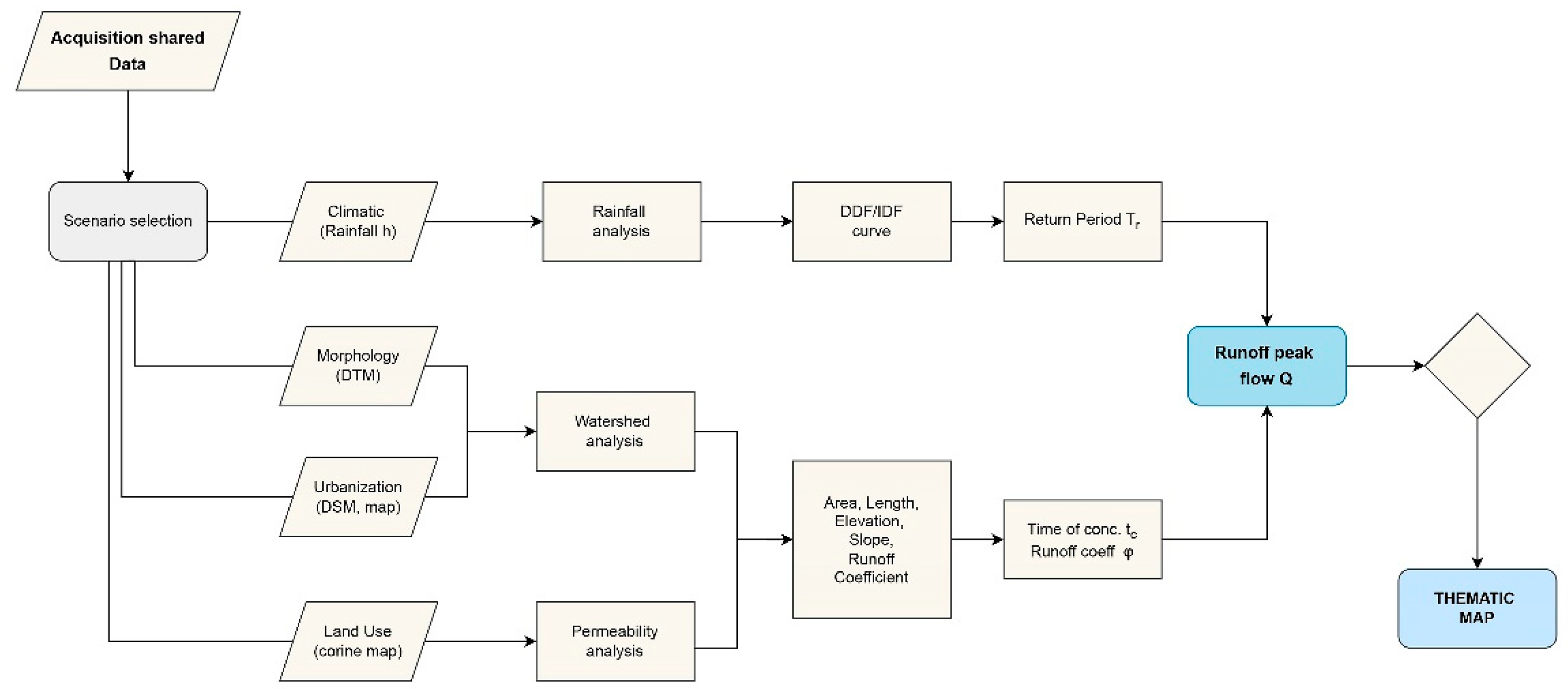
The general principles of the hydromorphic analysis propose a hierarchical approach (
Figure 1) based on different steps:
morphological analysis of the urban area and urban watershed assessment, both conducted by considering the DTM of a zone large enough to include all the peculiarities of the area of interest;
physical analysis of all the watersheds and evaluation of the descriptive parameters (area, perimeter, length, elevation, slope, permeability);
hydrological analysis of the maximum rainfall data to evaluate the DDF/IDF curve (Depth/Intensity-Duration-Frequency) that describe the rainfall events for different frequency (return period), and for a given location;
hydrological evaluation of the expected runoff at the outlet point of each basin;
All applied to different selected scenarios (physical or climatic) in order to evaluate the corresponding system reactions that reflect the morphological ability of the urban area to face any specific situation.
In previous articles the hydromorphic approach was [
53] applied on a large scale, covering the entire urbanized territory of Matera, up to the most peripheral portions, to evaluate a homogeneous index (Hydraulic Invariance) to facilitate a comparative analysis of various geographical section and create vulnerability maps of the entire city.
In the present work we present an approach which, although using the same methodology, is applied to the detailed scale of a single basin, in order to verify the ability of the proposed method to also read the effects of local transformations that affect limited parts of a single area. The chosen watershed resulted of particular interest because in the previous analysis it showed the most critical conditions, it includes the area of high historical and tourist value of Sasso Caveoso and, furthermore, it is periodically affected by flooding and surface runoff phenomena threatening the inhabitants and any activity present in the area.
The present research applies the hydromorphic methodology to a case study representative of a process of urban evolution which allows us to confirm the advantages of this approach. In particular, identifying the natural interactions between different areas or districts, evaluating the effects of the urban transformations acted by the urban evolution and measuring the corresponding impacts in terms of peak surface runoff.
The present work proposes an approach that can support urban planning activities in defining the contribution that each area can make to pursue the sustainability required by the 2030 agenda (Sustainable Development Goals, Goal 11: Smart Cities and Communities, Goal 13: Climate Action ).
2.1.1. Morphological Analysis
The morphological analysis is conducted by processing the DTM of the area to be examined with the GRASS tools r.watershed and r.water.outlet [
54]which allows the recognition of all the basins and the respective hydrographic networks, evaluating also the physical characteristic parameters (area, perimeter, average slope, slope of the main path, minimum and maximum elevation, ..) necessary to develop the rainfall-runoff analysis. The process is performed by the open source software Q-GIS [
55] using the GRASS plugins.
The permeability parameters of each basin have been evaluated according to the land use maps, associating to any homogeneous area the proper runoff coefficient φ
i usually considered (
Table 1) in hydrological studies, but considering only two categories: pervious and impervious areas.
The global runoff coefficientφ(Equation 1) of the single basin can therefore be obtained by operating an area-weighted average of the φ
i related to the different homogeneous elementary areas:
where:
φi are the runoff coefficient of each homogeneous area
Si are the homogeneous areas
Stot is the global area of the watershed
The critical conditions of the basins (maximum basin runoff) are related to events that have durations equals to the time of concentration t
c (time taken by the precipitation particle falling at the hydraulically farthest point to reach the outlet point). The well known Kirpich formula [
56] allows to estimate the time of concentration t
c (Equation2) on the basis of the geometric parameters evaluated from the GIS analysis.
where:
tc (hours) is the time of concentration
L (m) is the length of the mainstream path
s (dimensionless) is the average slope of terrain conveying the overland flow
2.1.2. Hydrological Analysis
The hydrological analysis involves two steps:
the rainfall analysis, which considers the recorded rainfall data and applies the usual statistical methods for rainfall analysis [
57]to estimate the DDF curve (Depth-Duration-Frequency - Equation 3) and the IDF curve (Intensity-Duration-Frequency Equation 4) for different return period T
r
where: “a” and “n” are related to the return period T
r
the runoff analysis that models the rainfall-runoff process adopting the well known and widely used Rational Method [
56,
57] in order to evaluate the maximum Q (Equation 5) at the basin outlet:
where Q at the watershed outlet, is strictly related to the physical condition of the basin (the runoff coefficient φ), to the climatic scenario (the intensity of precipitation i related to the time of concentration tc), to the shape of the basin (the surface S) and to the hydrological response of basin (the time of concentration tc).
Equation 5 expresses the combined effect of the actions that modify the shape, dimensions or physical characteristics of the basin (φ, tc, itc, S) through a quantitative indicator that represents the runoff in the basin outlet for various criticality level Tr of the rainfall events considered.
3. Results
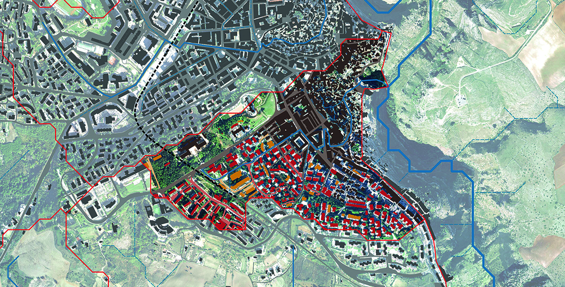
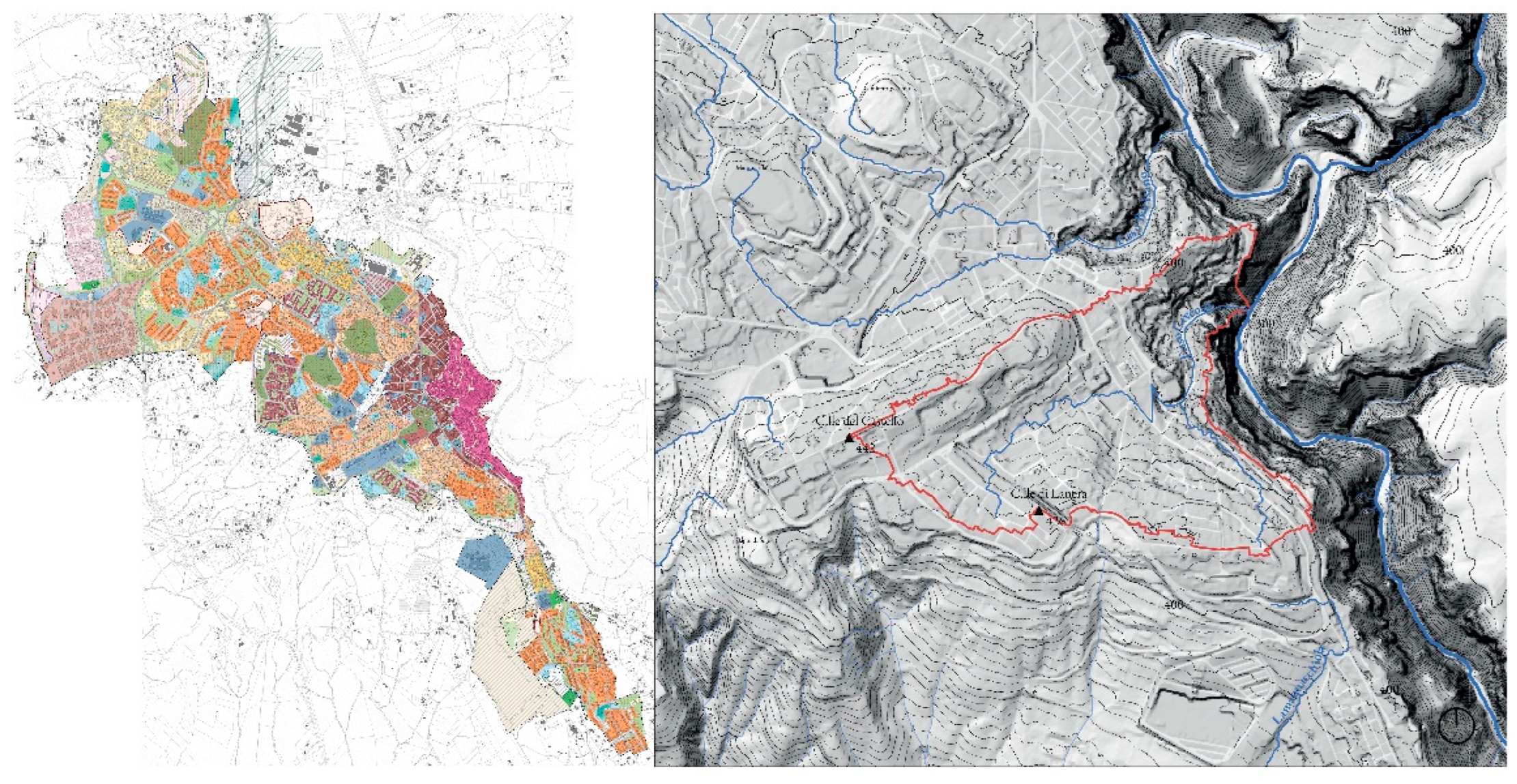
To fully explain the proposed hydromorphic method, a case study related to one of the historic districts of the city of Matera named “Sasso Caveoso” (
Figure 2) was investigated.
3.1. The Case Study
The Sasso Caveoso district is one of the two oldest historic areas of the city, it extends from the lower edge of S. Pietro Caveoso square, includes part of the Tramontano Castle Hill and reaches the top of the hill the Lanera district.
The city of Matera has changed its urban structure, transforming and evolving to its current configuration, which responds to the growing needs of urban development, new services and modern infrastructure. Three particular moments in the urban development of the city can be considered: the first settlements of the Sassi, the expansions of the historic centre and the contemporary city with the creation of the external districts. In the last 70 years, Matera has almost doubled its inhabitants (38000 in 1954, 60000 in 2017) and almost tenfold its urban extension (80 Ha in 1954, 680 Ha in 2017).
The spatial and temporal variability of the different morphological and urban planning components that affected the city allow the hydromorphic analysis of the territory to be applied to a context that allows the proposed methodology to be tested, providing useful causes for reflection.
The districts that have undergone the most important transformations are those of the historic centre and in particular the Sassi Barisano and Caveoso which originally developed around the two deep torrential incisions of the Grabiglioni, adopting houses organized in overlapping layers. In the Sassi the waters of different origins were accumulated in cisterns dug into the rock and connected to the roofs and impermeable surfaces of the courtyards or streets [
58,
59,
60]. From the roofs of the houses the outflows were conveyed into tanks of approximately 5-15 m
3, single or connected to guarantee the integrated accumulation of resources and the reduction of waste to a minimum. While the Grabiglioni naturally conveyed surface runoff and were used to discharge domestic sewer wastes.
The first expansion of the Sassi involved the surrounding areas (the Piano) where buildings of great value were built (palaces, churches and public buildings). Then in the 1900s, the abnormal demographic increase of the population within the Sassi, forced the evolution of the Sassi towards the upper parts and the two Grabiglioni Barisano and Caveoso were covered to transform them into sewer collectors and the access roads to the Sassi were built on them.
Nowadays, the Sassi have become modern residential and touristic districts, they have efficient water and sewerage infrastructures that guarantee water resources and ensure safe sewer, but do not determine an equally efficient protection of the territory from surface runoff phenomena resulting from rainfall, especially in the most exposed urban areas, located downstream in the historic districts.
Figure 3.
Urban evolution of Matera.
Figure 3.
Urban evolution of Matera.
3.2. Hydromorphic Approach
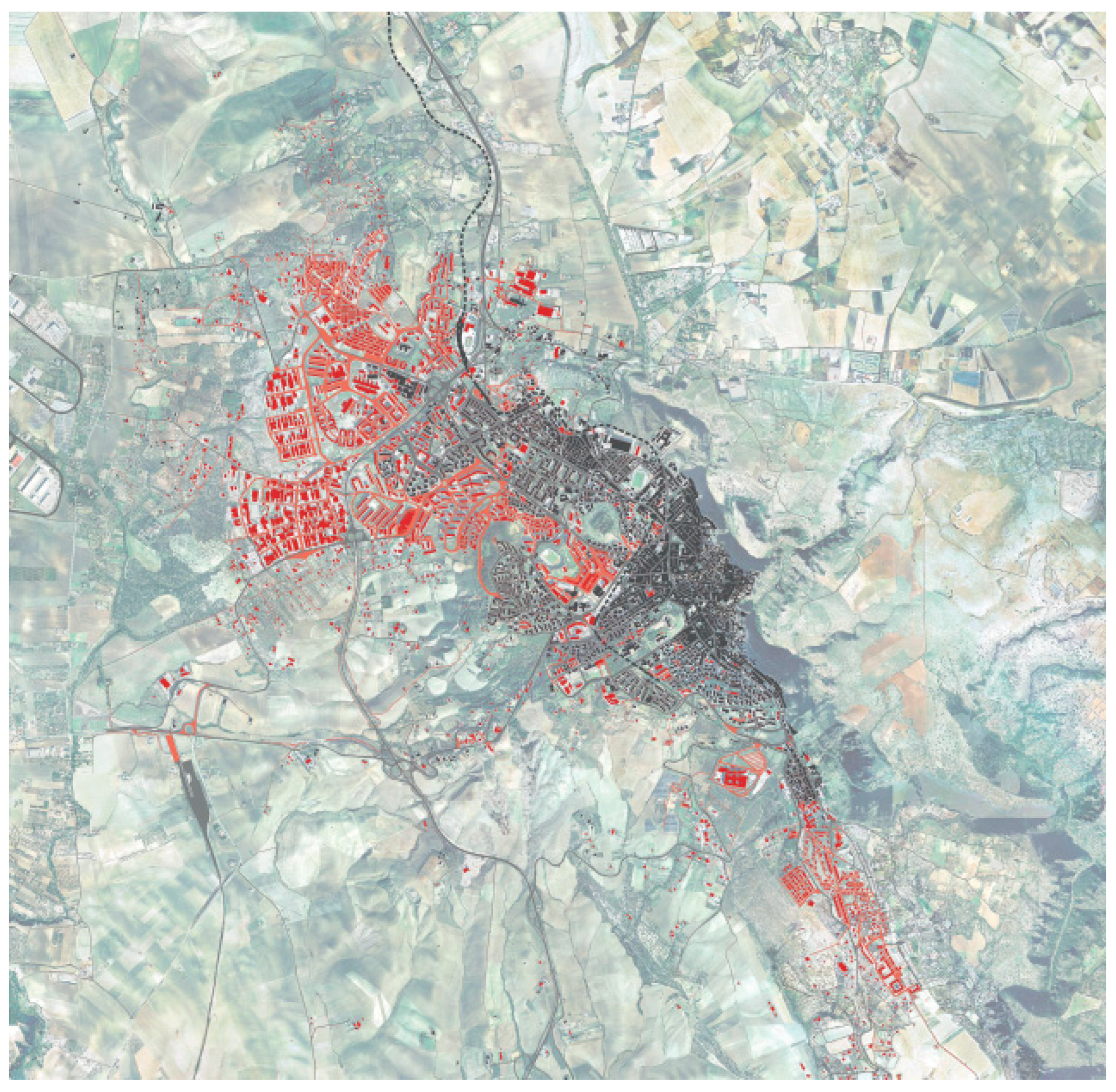
By applying the methodology described (chapter 2) the DTM map of the city of Matera was examined through the Q-GIS/GRASS software [
54,
55], allowing to identify 21 independent urban basins (
Figure 4). The Sasso Caveoso old district is included into the GM2watershed.
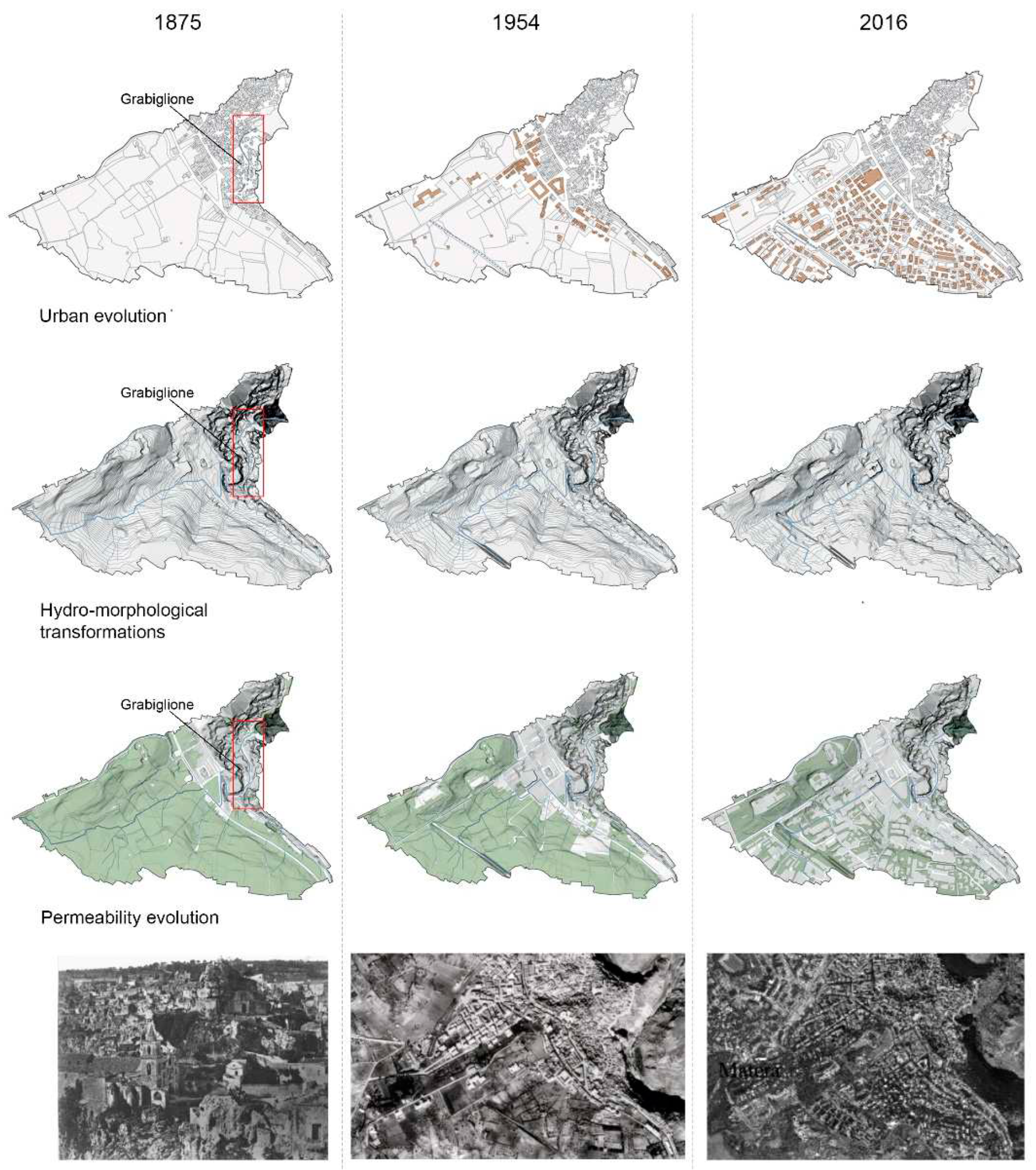
By analyzing in detail the evolution of the basin GM2which includes the Sasso Caveoso, it is possible to meticulously describe all the changes induced by urban evolution over the last 140 years.
Matera has its rain gauge station managed by the Regional Civil Protection Agency. Analyzing the last 30 years of the annual maximum hourly rainfall records, the DDF and IDF curves (a and n parameters), were derived (
Table 2), referring to different return period T
r ranging from 5 to 200 years.
Each DDF or IDF curve expresses a proper climatic condition that could be considered to describe a specific scenario.
The considered basin GM2 has modified the shape, size, slope, main flow path network and the overall runoff coefficients φ, consequently having an impact on all the parameter previously cited that affect the hydrologic response of the watershed and particularly the outlet peak runoff.
The basin GM2, over time, kept intact its global extension S (0.66 Km2), but has undergone wide morphological and land use changes:
in 1875, the old district stood only on the basin downstream, while the remaining part was left unspoiled; the natural hydrographic network that crossed the entire basin, reached the urbanized area, assumes an engraved shape protected by wall edges and the stream acquired the name Grabiglione;
in 1954, the urban area expanded towards the upper closest flat areas, the Grabiglione stream was entirely covered, creating an underground sewer overlapped by a road, and a railway was built in the upper part of the basin, intercepting and diverting the natural runoff;
in 2016, the expansion of the urbanized area continued, transforming almost the entire upper basin area, except for a few green spaces.
From the hydromorphic point of view, the occurred urban transformations entail increase in runoff coefficients φ and decrease in time of concentrations tc. Furthermore, higher rainfall intensities itc result from the IDF curve (Equation 4) and, consequently, the maximum outlet runoff Q (Equation 5) tends to increase considerably.
Figure 5.
Evolutive Behaviors of the Sasso Caveoso watershed.
Figure 5.
Evolutive Behaviors of the Sasso Caveoso watershed.
Considering the climate scenario T
r=20 years the hydromorphic analysis of the previous described evolution reflects exactly (
Table 3) the described dynamics, where a considerable peak flow rate growth occurs over time.
In the case study examined (Sasso Caveoso) it is clear that the hydromorphic analysis of the basin allows us to recognize the profound physical relationships that exist between the historic district and the subsequent expansion part, which must be considered in their morphological unity and not as separate administrative bodies. The hydromorphic response of the basin has worsened significantly over time, especially due to the expansion of urbanized upstream areas which have reduced the permeability of the soil and its capacity to intercept rainfall. At the same time, road and railway works were also carried out which diverted the main flows and covered the valley torrential bed (Grabiglione torrent). The set of urban transformations has altered the hydrological response of the basin and this is well expressed by the Q parameter, evaluated at the outlet watershed point, which has almost doubled over time.
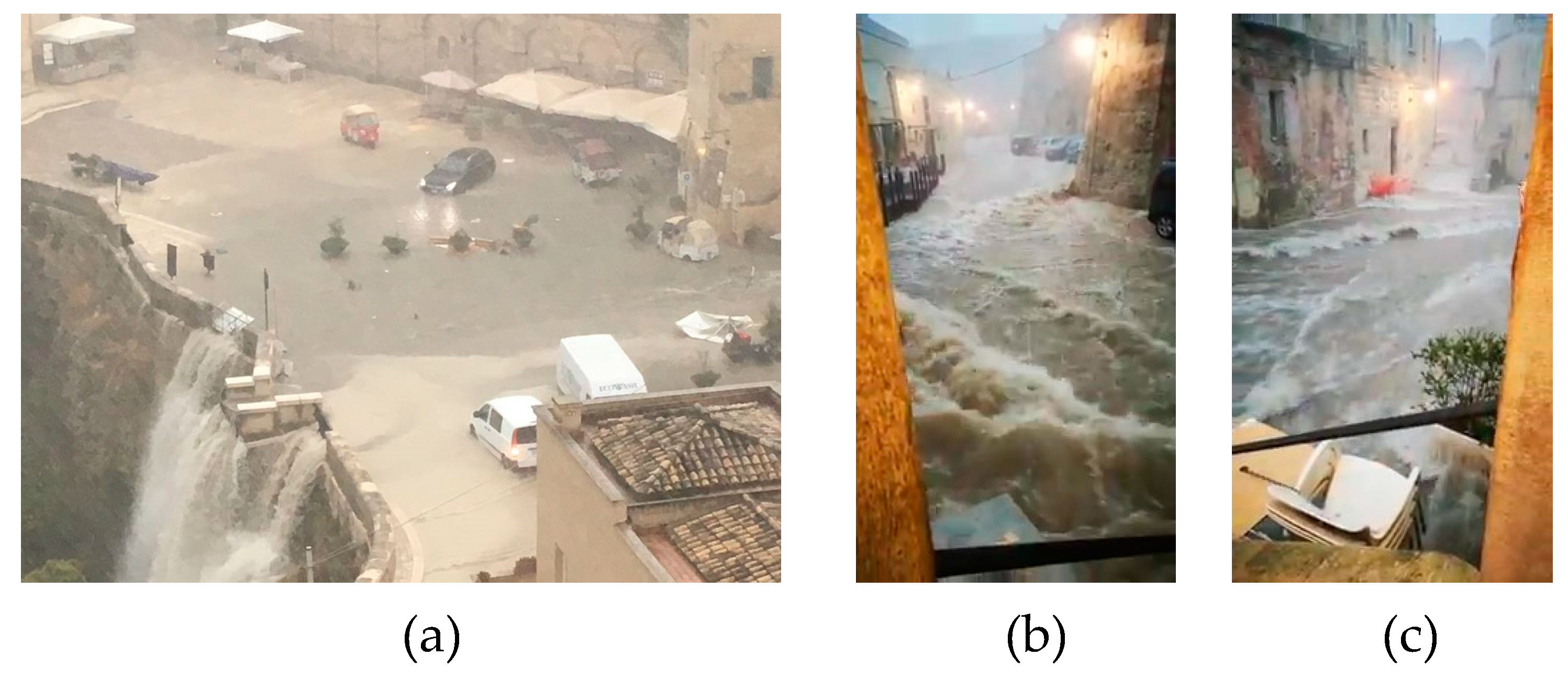
The consequences of hydromorphic alterations produce very critical situations during climatic events of a certain importance which determine tumultuous flows along the main roads, widespread flooding of courtyards and lower floors and the flooding of Piazza San Pietro Caveoso (a major tourist attraction point) located at the downstream end of the basin, where there are various commercial and tourist venues.(
Figure 6)
Figure 5.
Sasso Caveoso during intense rainfall event: (a) S. Pietro Caveoso square, (b, c) the old path of the Grabiglione actually Bozzi street.
Figure 5.
Sasso Caveoso during intense rainfall event: (a) S. Pietro Caveoso square, (b, c) the old path of the Grabiglione actually Bozzi street.
4. Discussion and Conclusion
It is clear that cities and territorial transformations have a strong impact on the rainfall-runoff processes dynamic, on the infiltration capacity guaranteed by permeable areas and that the runoff impact on the liveability and safety of natural and non-natural spaces. Also the conformation of urban areas can be affected by the different exposures that characterize the variability of rainfall observed in different parts of the city [
61,
62,
63,
64]. Ultimately, the materials used, the infrastructure present or the technical choices adopted, can also influence the dynamics of the involved processes.
There is a particularly strong need to develop operational tools capable of carrying out assessments on the efficiency conditions of the different alternative hypotheses to be evaluated, in order to be able to support sustainable planning processes. [
67].
Several initiatives adopt sustainable urban planning policy known as Water Sensitive Urban Design (WSUD) and Sustainable Urban Drainage (SUD). WSUD were introduced in the Water Sensitive Urban Design Guidelines (WSUDG) developed in Australia in order to integrate storm water management into the planning and design of urban areas [
68].
Sustainable Urban Drainage promotes a new approach to the management of rainwater in an urban environment, which appeared in the 1987 "Our Common Future" report [
69] (or "Brundtland Report", named after the president of the World Commission on Environment and Development of the United Nations, Gro Harlem Brundtland)in which the critical points and global environmental problems and the need to start a community strategy were noted - the concept of "sustainable development ” in its meaning of economic growth and development but also of social order.
The present paper has suggested an insightful methodology able to assess the impacts of urban characteristics on hydrological dynamics, adopting open source software widely diffused that allows the evaluation of global indicators of the watershed response, to detect the role of any different transformation and compare different climate conditions or project layouts. The proposed approach provides proactive Urban planning tools that facilitate the utilization of storm water Best Management Practices (BMPs) and Best Planning Practice (BPP) including engineering, architecture and ecology aspects in order to account for site-specific characteristics and develop different range scales (local and regional) integration.
The described methodology, throughout the hydromorphic analysis, can support urban planning activities in pursuing the sustainability target suggested by the 2030 agenda (Sustainable Development Goals, Goal 11: Smart Cities and Communities, Goal 13: Climate Action).
Author Contributions
The individual contributions provided by Authors are: R. Ermini, Conceptualization, methodology, formal analysis, validation, supervision, project administration and funding acquisition; C. Fattore software, data curation, writing and editing, A. Zoubi visualization, language supervision. All authors have read and agreed to the published version of the manuscript.
Funding
This research received external funding from Ministero dell’Istruzione, dell’Università e della Ricerca Progetti di Rilevante Interesse Nazionale- Urban Resilience to Climate Change: to Activate participatory mapping and decision support tool for enhancing the sustainable urban drainage (PRIN-URCA 2020 –Ref.n 20208TAK3H).
Conflicts of Interest
The authors declare no conflict of interest.
References
- Chen, Y.; Zhou, H.; Zhang, H.; Du, G.; Zhou, J. Urban flood risk warning under rapid urbanization. Environ. Res. 2015, 139, 3–10. [Google Scholar] [CrossRef]
- Sun, S.; Zhai, J.; Li, Y.; Huang, D.; Wang, G. Urban waterlogging risk assessment in well-developed region of Eastern China. Physics and Chemistry of the Earth 2020, 115, 102824. [Google Scholar] [CrossRef]
- Walsh, C. J.; Roy, A. H.; Feminella, J. W.; Cottingham, P. D.; Groffman, P. M.; Morgan, R. P. The urban stream syndrome: current knowledge and the search for a cure. J. of the North American Benthological Society 2005, 24, 706–723. [Google Scholar] [CrossRef]
- Fox, D. M.; Witz, E.; Blanc, V.; Soulié, C.; Penalver-Navarro, M.; Dervieux, A. A case study of land cover change (1950–2003) and runoff in a Mediterranean catchment. Applied Geography 2012, 32, 810–821. [Google Scholar] [CrossRef]
- Dams, J. ,Dujardin J.,Reggers, R.; Bashir, I.; Canters F.,Batelaan O. Mapping impervious surface change from remote sensing for hydrological modeling. J. Hydrology 2013, 485, 84–95. [Google Scholar] [CrossRef]
- Horton, R.; Ankeney, M.D.; Allmaras, R.R. Effects of compaction on soil hydraulic properties. In: B.D. Soane and C. van Ouwerkerk, eds., Soil compaction in crop production. Amsterdam: Elsevier Science, 1994, B.V.
- Richard, G.; Cousin, I.; Sillon,J. F.; Bruand, A.; Guérif, J. Effect of compaction on the porosity of a silty soil: influence on unsaturated hydraulic properties. European Journal of Soil Science 2001, 52, 49–58. [Google Scholar] [CrossRef]
- IPCC, 2014: Climate Change 2014: Synthesis Report. Contribution of Working Groups I, II and III to the Fifth Assessment Report of the Intergovernmental Panel on Climate Change [Core Writing Team, R.K. Pachauri and L.A. Meyer (eds.)]. IPCC, Geneva, Switzerland.
- Aalbers, E. E.; Lenderink, G.; van Meijgaard, E.; van den Hurk, B. J. J. M. Local scale changes in mean and heavy precipitation in Western Europe, climate change or internal variability? Clim. Dynam. 2018, 50, 4745–4766. [Google Scholar] [CrossRef]
- Martel, J. L.; Mailhot, A.; Brissette, F. Global and regional projected changes in 100-year sub-daily, daily and multi-day precipitation extremes estimated from three large ensembles of climate simulation. J. Clim. 2019, 1–44. [Google Scholar]
- Innocenti, S.; Mailhot, A.; Leduc, M.; Cannon, A. J.; Frigon, A. Projected changes in the probability distributions, seasonality, and spatiotemporal scaling of daily and subdaily extreme precipitation simulated by a 50-member ensemble over northeastern North America. J. Geophys. Res. Atmos. 2019, 124, 10427–10449. [Google Scholar] [CrossRef]
- Sillmann, J.; Kharin, V.V.; Zwiers, F. W.; Zhang, X.; Bronaugh, D. Climate extremes indices in the CMIP5 multimodel ensemble: Part 2. Future climate projections. J. Geophys. Res. Atmos. 2013, 118, 2473–2493. [Google Scholar] [CrossRef]
- Fischer, E. M.; Knutti, R. Observed heavy precipitation increase confirms theory and early models. Nat. Clim. Change 2016, 6, 986–991. [Google Scholar] [CrossRef]
- European Environment Agency. Flood risk in Europe: the long-term outlook,2013,http://www.eea.europa.eu/highlights/flood-risk-in-europe-2013 (accessed 27Septemeber 2023).
- Feyen, L.; Dankers, R.; Bodis, K.; Salamon, P.; Barredo, J. I. Fluvial flood risk in Europe in present and future climates. Clim. Change 2012, 112, 47–62. [Google Scholar] [CrossRef]
- Dunne, T.; Leopold, L. B. Water in environmental planning. New York: Freeman publications, 1978.
- Arnold, C. L.; Gibbons, C. J. Impervious surface coverage: the emergence of a key environmental indicator. J. American Planning Association 1996, 62, 243–258. [Google Scholar] [CrossRef]
- Leopold, L. B. Hydrology for urban land planning – a guidebook on the hydrologic effects of urban land use, geological survey circular 554. Washington, DC: United States Department of the Interior Publication, 1968.
- Konrad, C.P. US geological survey fact sheet 076-03: effects of urban development on floods.2013.Available from: http://pubs.usgs.gov/fs/fs07603/.
- Hirsch, R.M.; Walker, J. F.; Day J., C.; Kallio, R. The influence of man on hydrologic systems. In: M.G. Wolman and H.C. Riggs, ed. Surface water hydrology (the geology of America, vol. 0–1), 1990,Boulder, CO, 329–359.
- Hollis, G.E. The effect of urbanization on floods of different recurrence interval. Water Resources Research 2010, 11, 431–435. [Google Scholar] [CrossRef]
- Houston, D.;Werritty, A.; Bassett, D.; Geddes, A.; Hoolachan, A.; McMillan,M. Pluvial (rain-related) flooding in urban areas: the invisible hazard. Joseph Rowntree Foundation.2011. Available from: http://www.jrf.org.uk/sites/files/jrf/urban-flood-risk-full.pdf(Accessed 27 September 2023).
- Packman, J. C. The effect of urbanization on flood magnitude and frequency. In: G.E. Hollis, ed. Man’s influence on the hydrological cycle in the United Kingdom.Norwich: GeoBooks, 1979, pp. 153–172.
- Paul, M. J.; Meyer J., L. Streams in the urban landscape. Annual Review of Ecology and Systematics 2001, 32, 333–365. [Google Scholar] [CrossRef]
- O’Driscoll, M.; Clinton, S.; Jefferson, A.; Manda, A.; McMillan, S. Urbanization Effects on Watershed Hydrology and In-Stream Processes in the Southern United States. Water 2010, 2, 605–648. [Google Scholar] [CrossRef]
- Domenech, L.; Sauri, D.; Sauri, D. A comparative appraisal of the use of rooftop rainwater in single and multi-family buildings of the Metropolitan Area of Barcelona (Spain): social experience, drinking water savings and economic costs. J. Cleaner Production 2011, 19, 598–608. [Google Scholar] [CrossRef]
- Wong, T. H. F. Water sensitive urban design – the journey thus far. Environment Design Guide 2007, 11, 1–10. [Google Scholar] [CrossRef]
- Yigitcanlar, T.; Dizdaroglu D. Ecological approaches in planning for sustainable cities. A review of the literature, Global J. Environ. Sci. Manage. 2015, 1, 159-188.
- ARE,2004. Sustainability assessment: Conceptual framework and basic methodology, Swiss Federal Office for Spatial Development, Berne.
- Kron, W.; Eichner, J.; Kundzewicz, Z. W. Reduction of flood risk in Europe – Reflections from a reinsurance perspective. J. Hydrol. 2019, 576, 197–209. [Google Scholar] [CrossRef]
- Berndtsson, R.; Becker, P.; Persson, A.; Aspegren, H.; Haghighatafshar, S.; Jonsson, K.; Larsson, R.; Mobini, S.; Mottaghi, M.; Nilsson, J.; Nordstrom, J.; Pilesjo, P.; Scholz, M.; Sternudd, C.; Sorensen, J.; Tussupova K. Drivers of changing urban flood risk: A framework for action. J. Environ. Manage. 2019, 240, 47–56. [Google Scholar] [CrossRef]
- Bruwier, M.; Maravat, C.; Mustafa, A.; Teller, J.; Pirotton, M.; Erpicum, S.; Archambeau, P.; Dewals, B. Influence of urban forms on surface flow in urban pluvial flooding. J. Hydrol. 2020, 582, 124493. [Google Scholar] [CrossRef]
- Choubin, B.; Moradi, E.; Golshan, M.; Adamowski, J.; Sajedi-Hosseini, F.; Mosavi, A. An ensemble prediction of flood susceptibility using multivariate discriminant analysis, classification and regression trees, and support vector machines. Sci. Total Environ. 2019, 651, 2087–2096. [Google Scholar] [CrossRef]
- Sadler, J. M.; Haselden, N.; Mellon, K.; Hackel, A.; Son, V.; Mayfield, J.; Blasé, A.; Goodall, J. L. Impact of Sea-Level Rise on Roadway Flooding in the Hampton Roads Region. Virginia. J. Infrastruct. Syst. 2017, 23, 05017006. [Google Scholar] [CrossRef]
- Tehrany, M. S.; Pradhan, B.; Jebur, M. N. Spatial prediction of flood susceptible areas using rule based decision tree (DT) and a novel ensemble bivariate and multivariate statistical models in GIS. J. Hydrol. 2013, 504, 69–79. [Google Scholar] [CrossRef]
- Zhao, G.; Pang, B.; Xu, Z.; Yue, J.; Tu, T. Mapping flood susceptibility in mountainous areas on a national scale in China. Sci. Total Environ. 2018, 615, 1133–1142. [Google Scholar] [CrossRef]
- Ahmad, S.S.; Simonovic, S. P. Spatial and temporal analysis of urban flood risk assessment. Urban Water J. 2013, 10, 26–49. [Google Scholar] [CrossRef]
- Son, N. T.; Trang, T. T. N.; Bui, X. T.; Thi Da, C. Remote sensing and GIS for urbanization and flood risk assessment in Phnom Penh. Cambodia. Geocarto Int. 2021, 1–18. [Google Scholar]
- Cherqui, F.; Belmeziti, A.; Granger, D.; Sourdril, A.; Le Gauffre, P. Assessing urban potential flooding risk and identifying effective risk-reduction measures. Sci. Total Environ. 2015, 514, 418–425. [Google Scholar] [CrossRef]
- Liu, L.; Jensen, M. B.; Zhang, X. Urban Water Management in Beijing and Copenhagen: Sustainability, Climate Resilience, and the Local Water Balance. In: Delman, J., Ren, Y., Luova, O., Burell, M., Almén, O. (eds) Greening China’s Urban Governance. ARI - Springer Asia Series,2021, vol 7. Springer, Singapore.
- Zhang,Q. ; Wu, Z.; Zhang, H.; Dalla Fontana, G.; Tarolli, P. Identifying dominant factors of waterlogging events in metropolitan coastal cities: The case study of Guangzhou. China. J. Environ. Manage. 2020, 271, 110951. [Google Scholar] [CrossRef]
- Hemmati, M.; Ellingwood, B. R.; Mahmoud, H. N. The Role of Urban Growth in Resilience of Communities Under Flood Risk. Earths. Future 2020, 8. [Google Scholar]
- Ten Veldhuis, J. A. E.; Clemens, F. Flood risk modelling based on tangible and intangible urban flood damage quantification. Water Science & Technology.
- Rudari, R.; Gabellani, S.; Delogu, F. Asimple model to map areas prone to surface water flooding. Inter. J. Disaster Risk Reduction 2014, 10, 428–441. [Google Scholar] [CrossRef]
- Segnestam, L. Indicators of environment and sustainable development theories and practical experience, Wold Bank, New York, 2003.
- Gabrielsen, P.; Bosch, P. Environmental indicators: Typology and use in reporting.European Environment Agency, 2003 Copenhagen.
- Wheater, H.; Gober, P. Water security in the Canadian Prairies: Science and management challenges. Phil.Trans. R. Soc. A. 2013, 371, 20120409. [Google Scholar] [CrossRef] [PubMed]
- OECD 1993 core set of indicators for environmental performance reviews Environment Monographs No. 83 (Paris: Organisation for Economic Co-operation and Development).
- EEA 1999Environmental indicators: Typology and Overview (Copenhagen: European Environment Agency).
- Hoekstra, A. Y. Water supply in the long term: a risk assessment. Phys. Chem. Earth. 2000, 25, 221–6. [Google Scholar] [CrossRef]
- Wolman, A.The Metabolism of Cities.Scientific American, 213, Springer Nature, Los Angeles, 1965, 179-190.
- Kennedy, C.A.; Cuddihy, J.; Engel Yan, J. The changing metabolism of cities. J. Industrial Ecology 2007, 11, 43–59. [Google Scholar] [CrossRef]
- Albano, R., Ermini, R.; Hydromorphic analysis of urban areas transformations: the case study of the Matera city. IOP Conference Series: Earth and Environmental Science 1196, 2023, 012026, SBE23- Thessaloniki, GR.
- Neteler, M.; Bowman, M.H.; Landa, M.; Metz, M. "GRASS GIS: A multi-purpose open source GIS. " Environmental Modelling & Software 2012, 31, 124–130. [Google Scholar]
- Van der Kwast H.;Menke, K. QGIS for Hydrological Applications - Recipes for Catchment Hydrology and Water Management. Locate Press, Penticton, BC, 2022.
- Artina, S.; Calenda, G.; Calomino, F.; La Loggia, G.; Modica, C.; Paoletti, A.; Papiri, S.;Rasulo, G.; Veltri, P.Sistemi di fognatura. Manuale di Progettazione. CSDU – HOEPLI, Milano, 1997.
- Manfreda, S., Iacobellis V.; Fiorentino, M.Appunti di Idrologia Superficiale.Aracne Editrice, Roma 2010.
- Cotecchia, V.; Grassi, D. Stato di conservazione dei Sassi di Matera (Basilicata) in rapporto alle condizioni geomorfologiche e geomeccaniche del territorio e alle azioni antropiche. Arti grafiche Favia, Bari, 1975.
- Ermini, R.; Didio, L.; Pascale, S.; Sdao, F.“Infrastrutture idrauliche storiche nella città di Matera”, in Atti VI Rassegna Urbanistica Nazionale, INU Edizioni, Roma, 2010.
- Manfreda, S.; Mita, L.; Dal Sasso, S.F.; Dibernardi, F.R.; Ermini, R.; Mininni, M.V.; Bixio, A.; Conte, A.; Fiorentino, M. La Gestione delle risorse idriche nella Città dei Sassi (Matera). L’Acqua.
- Huff, F.A.; Changnon, S.A. Climatological assessment of urban effects on precipitation at St Louis. J. of Applied Meteorology 1972, 11, 823–842. [Google Scholar] [CrossRef]
- Shepherd,J. A review of current investigations of urban-induced rainfall and recommendations for the future. Earth Interactions 2005, 9, 1–27.
- Burian, S.; Shepherd, J. Effect of urbanization on the diurnal rainfall pattern in Houston. Hydrological Processes 2005, 19, 1089–1103. [Google Scholar] [CrossRef]
- Ashley, W. S.; Bentley, M. L.; Stallins J., A. Urban induced thunderstorm modification in the Southeast United States. Climatic Change 2012, 113, 481–498. [Google Scholar] [CrossRef]
- Gash, J. H. C. , Rosier, P. T. W.; Ragab, R. A note on estimating urban roof runoff with a forest evaporation model. Hydrological Processes 2008, 22, 1230–1233. [Google Scholar] [CrossRef]
- Ragab, R.; Rosier,P. ; Dixon, A.;Bromley,J.;Cooper, J. D. Experimental study of water fluxes in a residential area: 2. Road infiltration, runoff and evaporation. Hydrological Processes 2003, 17, 2423–2437. [Google Scholar] [CrossRef]
- Shaw, E. M.; Beven, J. K.; Chappell, N. A. ; Lamb,R. Hydrology in practice, C: London, 2010. [Google Scholar]
- WhelansConsultants. Planning and Management Guidelines for Water Sensitive Urban (Residential) Design, report prepared for the Department of Planning and Urban Development of Western Australia, 1994, ISBN 0 64615 468 0.
- Brundtland, G.Report of the World Commission on Environment and Development: Our Common Future. United Nations General Assembly Document A/42/427, 1987.
|
Disclaimer/Publisher’s Note: The statements, opinions and data contained in all publications are solely those of the individual author(s) and contributor(s) and not of MDPI and/or the editor(s). MDPI and/or the editor(s) disclaim responsibility for any injury to people or property resulting from any ideas, methods, instructions or products referred to in the content. |
© 2023 by the authors. Licensee MDPI, Basel, Switzerland. This article is an open access article distributed under the terms and conditions of the Creative Commons Attribution (CC BY) license (http://creativecommons.org/licenses/by/4.0/).
