1. Introduction
It is projected that the global population will surpass 9 billion by 2050, doubling the current figure in 75 years. This surge necessitates increased food production. While meet-ing this demand is imperative, challenges like global warming, climate change, and water resource issues underscore the urgency of safeguarding soil, water, and the environment. Despite a significant rise in population and consumption, the world's agricultural land can only expand by 10% [
1].
While soil is naturally regenerative, this process requires considerable time and specific conditions. Therefore, prioritizing soil protection and ensuring sustainable production are paramount. This involves endorsing sustainable practices, preserving existing resources, and ensuring continuity [
2]. Understanding the physical and chemical traits of soils and promoting their sustainable use significantly impacts agricultural productivity. Soil characteristics vary based on vertical and horizontal directions and formation conditions. Colluvial deposits, consisting of rocks and soil fractions detached and transported by gravitational forces, play a vital role in nutrient assessment and pedological studies [
3].
Colluvial soils are comprised of locally transported debris materials from sloping lands, deposited due to water erosion or landslides. These sediments serve as archives, offering insights into sedimentation, climate history, past pedogenesis, and land use phases. Originating around 5500 BC during the Neolithic Age in Central Europe, colluvial deposits reflect past human activities, such as forest clearing and land cultivation [
4,
5,
6,
7].
The colluvial soils is crucial for ensuring agricultural sustainability. In some regions with rugged geographical conditions, agriculture can be carried out if other factors, especially the climate factor, are suitable. The important issue is whether the soil-plant-water relationship is compatible with the desired form of agriculture.
The hypothesis of this research is that, according to the land capability classification system, if the slope is 10% or above, these lands are not suitable for agriculture. This phenomenon is especially evident in regions characterized by sloping topography. Lands under such topographic conditions have shallow and erosion-prone soil profiles and are not suitable for agricultural production. Limiting factors for crop plants include steep slopes, severe erosion, shallow soils, low water holding capacity, salinity, and alkalinity.
The aim of this study, in which the potential of colluvial lands to contribute to sustainable agricultural production is revealed for the first time, which have a very important portion in the Boz Mountains region in the West of Turkey, by examining the climate, geographical features, parent material and soil chemical and physical properties, and to investigate whether they are suitable for the cultivation of grapes, figs and olives, which are widely grown in the region.
Materials and Methods
2.1. Material
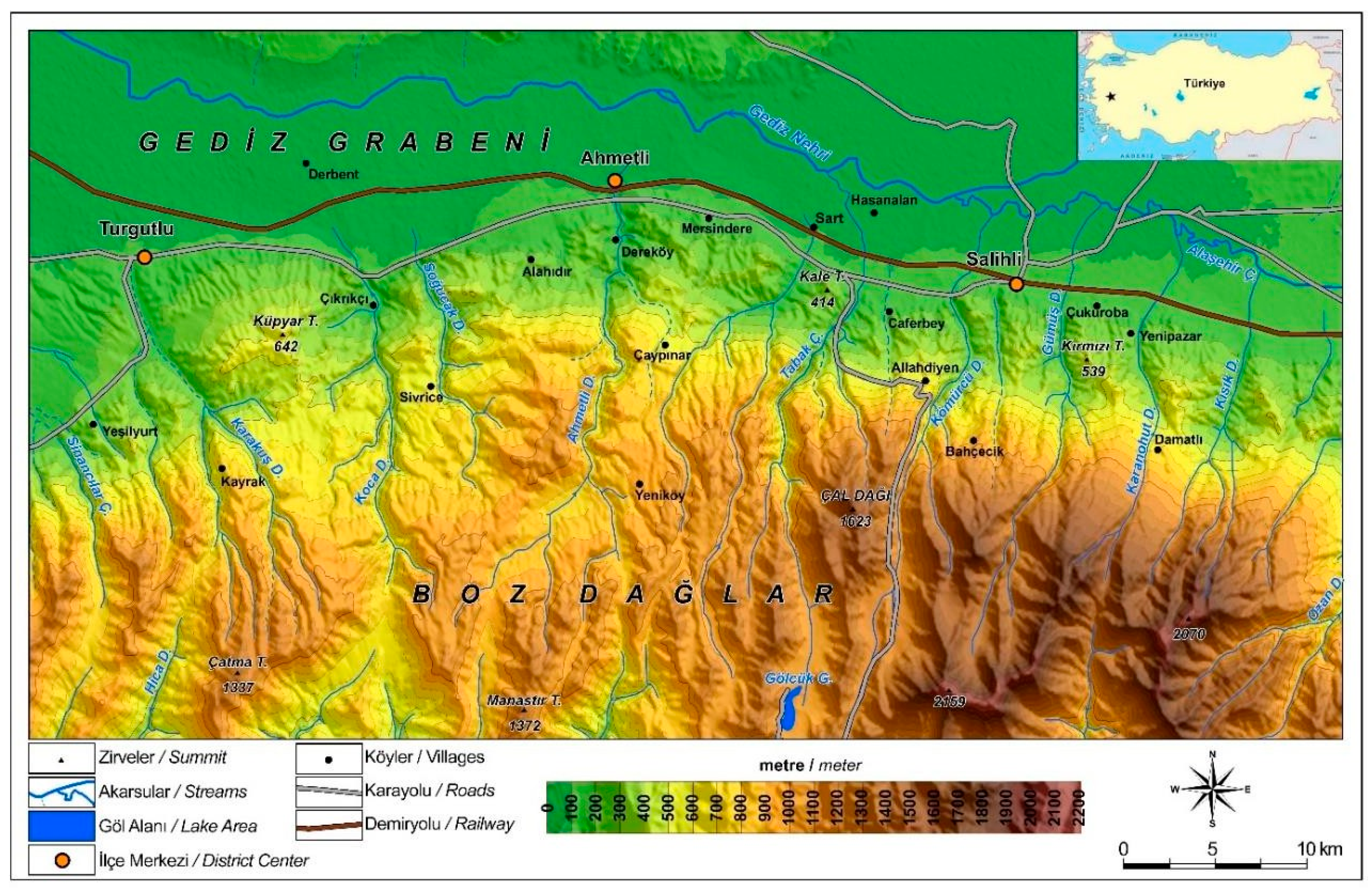
This research was conducted in the western part of Anatolia, specifically in the Aegean region, encompassing the Gediz graben, and including the northern slopes of the Boz Mountains and the southern slopes of the Aydın Mountains in Turkiye (
Figure 1). The study area is situated within the geographic coordinates of 38°31'13.13''N, 38°25'29.16''N, 37°45'36.22''E, and 37°50'10.37''E.
2.1.1. Climatic conditions
The study area exhibits two distinct types of Mediterranean climatic conditions. In the lower part of the region, Mediterranean conditions are characterized by mild and rainy winters, along with hot and dry summers. As one ascends beyond 1000 meters elevation in the Boz Mountains, an Oro-Mediterranean climate prevails. This climate is distinguished by snowy and cold winters, complemented by cool summers occasionally marked by orographic rainfall [
8].
The mean annual temperature, which stands at 17°C in the lowland areas, experiences a significant drop of 7-8°C in the upper reaches of the Boz Mountains. Annual precipitation averages nearly 500 mm in the lower part of the area, while this figure rises to over 600 mm in the higher elevations of the mountains. Precipitation, which can lead to erosion and flash floods, primarily occurs during the winter and early spring periods.
2.1.2. Geologic setting
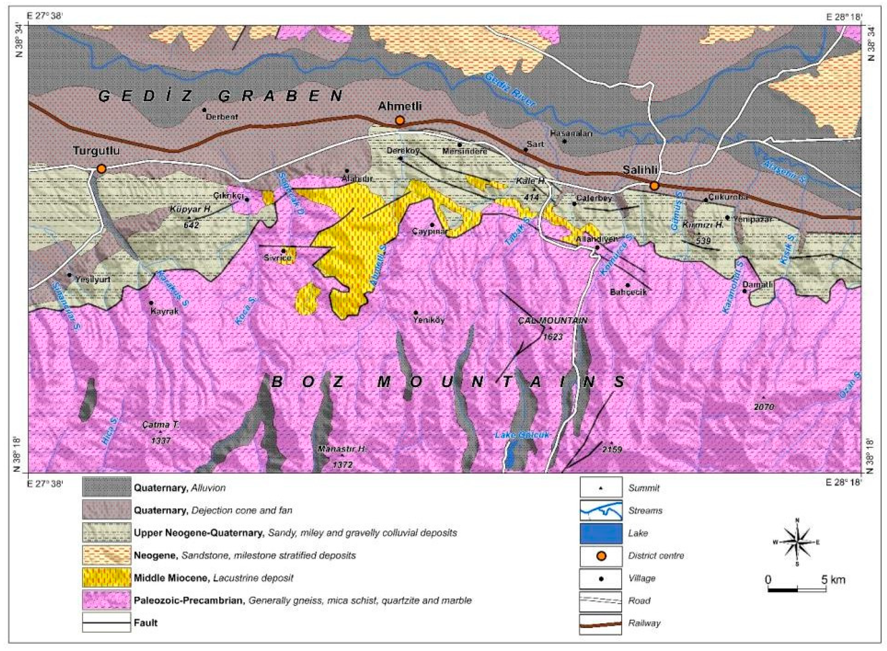
The geological composition of the study area comprises three primary formations: the Menderes Paleozoic massif, Neogene fluvio-lacustrine sediment, and Plio-Quaternary colluvial deposits, along with alluvial fans and dejection fans (
Figure 2). The Paleozoic Menderes massif, predominantly consisting of gneiss, mica schist, and quarzitic schist, stands as one of Turkiye's prominent rigid masses and underwent metamorphism during the Paleozoic era [
9,
10]. The Neogene fluvio-lacustrine sediment is prevalent in the lowland areas and the northern periphery of the Boz Mountains.
The Plio-Quaternary colluvial deposits that blanket the northern slopes of the Boz Mountains result from the accumulation of transported materials, including gravel, sand, and silt, with a minor presence of clay. These materials originate from the weathering of gneiss-mica schist on the Boz Mountains. The distinct colors and sizes of the colluvial deposits reflect various stages of erosion and accumulation during faulting movement periods.
Colluvial deposits exhibit three primary layers: the lower layer, characterized by a reddish hue, is intersected by faults; the middle layer, in brown, comprises predominantly silty and sandy materials; and the upper layer, in pale brown, represents the primary formation area of gullies. Extensive dejection cones and fans in the lowlands of the Gediz graben have formed through the accumulation of materials transported from the Boz Mountains.
Figure 2.
Geologic and lithologic map of Boz Mountain and Gediz graben.
Figure 2.
Geologic and lithologic map of Boz Mountain and Gediz graben.
2.1.3. Topography
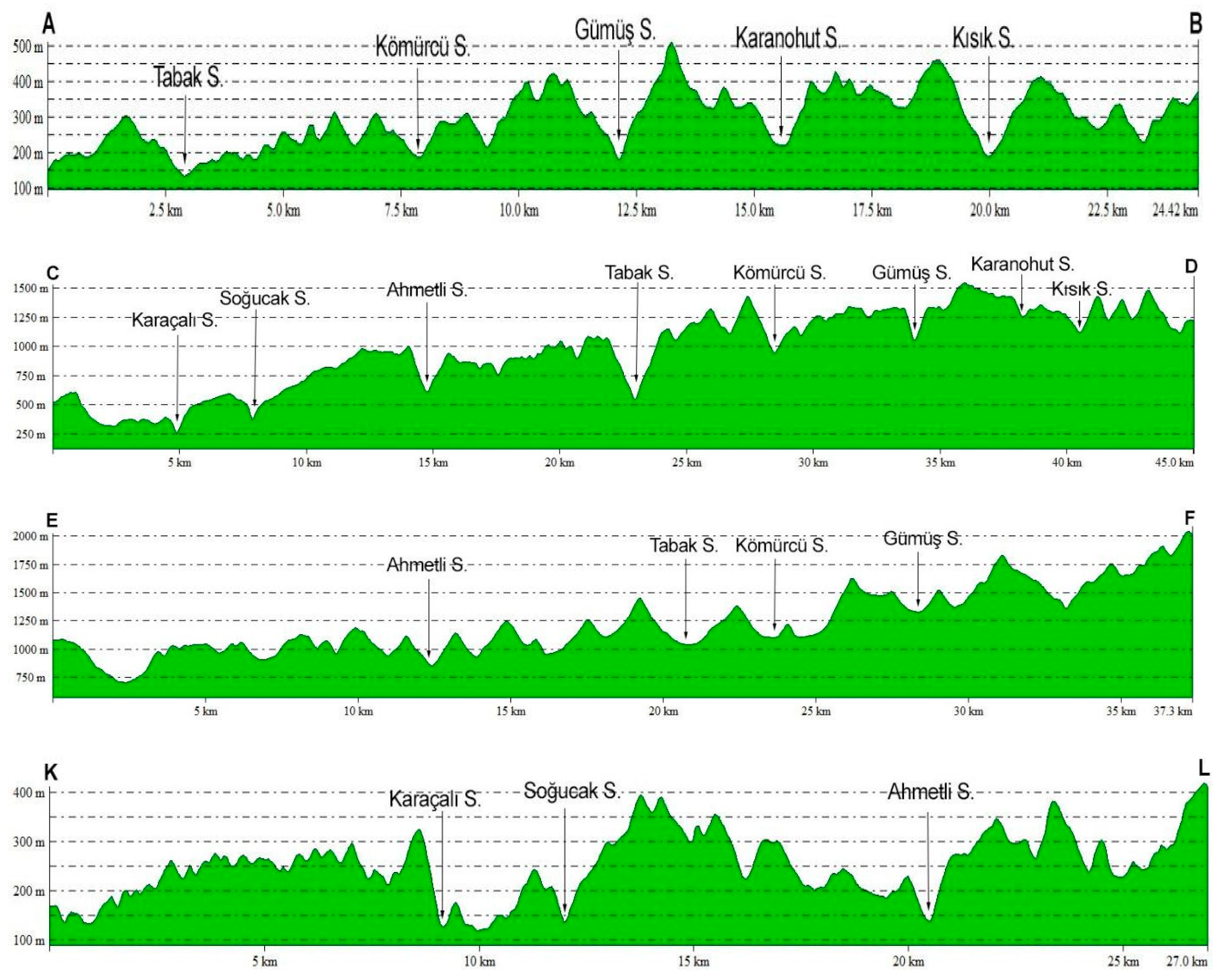
The research site is situated on the north-facing slopes of Boz Mountains, located in the southern region of the Gediz River Basin within western Anatolia. The Gediz lowland area, characterized as a graben, contrasts with the Boz Mountains, identified as a horst. The elevation of the study area ranges from 100-150 meters in the Gediz graben, gradually ascending to 2157 meters at the summit of Boz Mountains. This substantial altitudinal variation, exceeding 1500 meters (
Figure 3), defines the landscape. The Boz Mountains exhibit wide valleys and undulating topography, remnants of an ancient erosion surface formed during the Paleozoic Era. This pre-Neogene erosion surface, initially part of the Boz Mountains, underwent uplift due to vertical faulting movements. The resulting rugged topography is evident in colluvial deposits on the north-facing slopes, especially notable in gullies shaped by streams at the Gediz Graben level. These colluvial deposits, dissected by streams in alignment with the Gediz Graben, contribute to the creation of a challenging topography, reminiscent of the badland terrain found in the western part of the USA. Steep slopes, primarily along fault scarps, dominate the lower north slopes of Boz Mountains. The Gediz graben serves as a natural transportation route, connecting the Aegean Sea to the inland regions of Central Anatolia. This geological feature significantly contributed to the establishment of the Gediz River, which flows into the Aegean Sea.
The present-day topography of the Paleozoic metamorphic Menderes Massif and Gediz Graben has been shaped by vertical faulting movements occurring between the Middle Miocene and Late Quaternary periods. This horst-graben system's formation is primarily attributed to the northward movement of the African plate, particularly along the subduction zone extending across the Crete and Cyprus islands [
11,
12,
13]. The uplifting of the western Anatolia and Egeit microplate, driven by extensional movement, led to the dissection of the rigid Menderes Massif and Aegean microplate. The geomorphological evolution, including the formation of the horst-graben system and metamorphism, has been extensively discussed in the context of the Menderes Massif [
9,
10,
14]. This dynamic geological process underscores the intricate interplay of tectonic forces that have significantly influenced the landscape of the region over time.
Figure 3.
The topographic profiles in the east-west direction of the colluvial deposit on north slope of Boz Mountains.
Figure 3.
The topographic profiles in the east-west direction of the colluvial deposit on north slope of Boz Mountains.
Profiles in the east-west direction exhibit significant incision, reaching depths of up to 500 meters in the colluvial deposit, influenced by the stream within the area. The degree of incision or dissection varies, ranging from 200 to 300 meters in profiles A-B and K-L, while reaching nearly 500 meters in the upper sections of Kömürcü and Tabak streams in the D-C profile. Additionally, the profile traversing the upper part of Boz Mountains reveals evidence of an ancient erosion surface and expansive valleys during the pre-Neo-gene period.
2.1.4. Vegetation and human impact
The study area is characterized by two primary forest belts. The first, consisting of Turkish red pine (
Pinus brutia), extends from the lowland and ascends to elevations of 800-1000 meters. The second forest belt, dominated by black pine (
Pinus nigra), begins at higher elevations above the red pine belt and reaches up to 2000 meters [
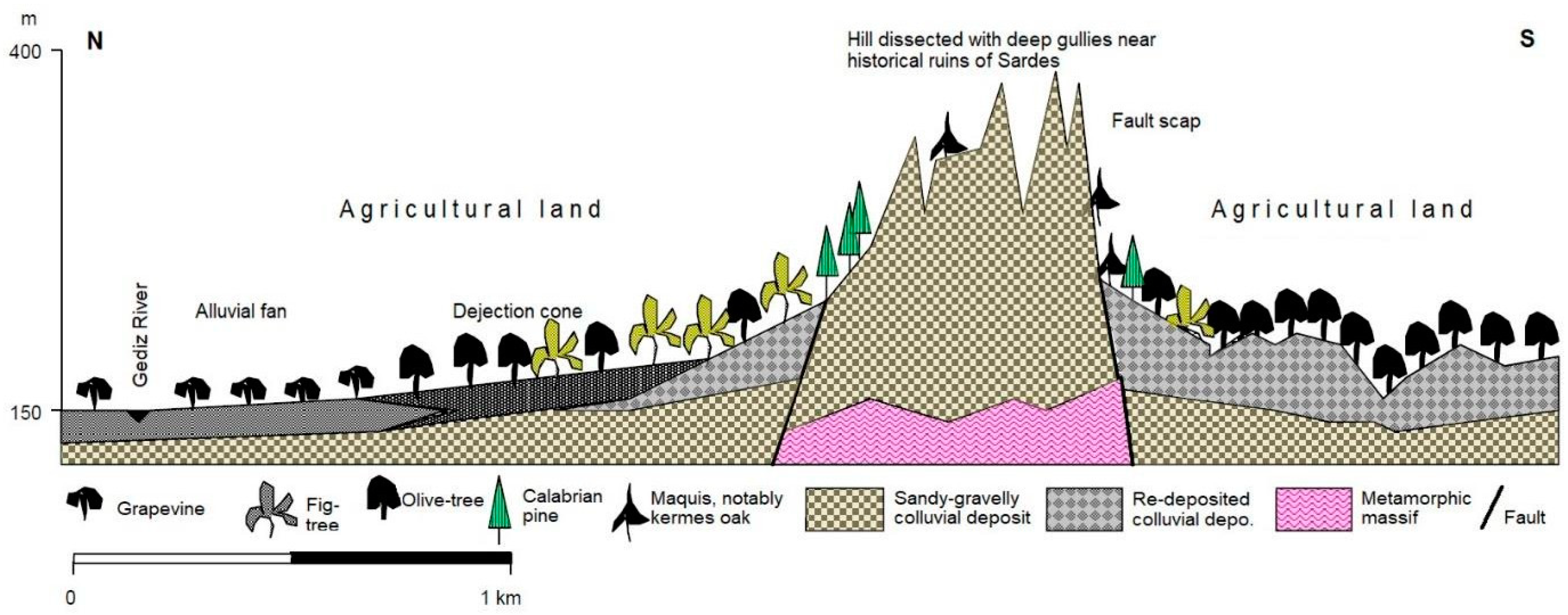
15]. Unfortunately, a considerable portion of these forest belts has been degraded or destroyed, contributing significantly to increased erosion, particularly the formation of gullies. Within this region, colluvial deposit slopes along the fault scarp of mini or small horst have undergone extensive dissection through the formation of deep gullies. Young slope deposits have formed through the accumulation of materials transported from horst slopes. Moreover, the materials transported from these slopes toward the Gediz graben have given rise to the creation of dejection cones and alluvial fans. The accumulation of sandysilty materials has notably impacted land use and agricultural activities. Specifically, the growth of fig and olive trees is closely tied to the presence of young colluvial deposits. In areas unsuitable for agriculture, maquis vegetation and red pine communities prevail (
Figure 4).
Figure 4.
The effects of the vertical faulting movements on the formation of mini horst-graben, the agricultural lands, gully and dejection cone in the vicinity of Salihli.
Figure 4.
The effects of the vertical faulting movements on the formation of mini horst-graben, the agricultural lands, gully and dejection cone in the vicinity of Salihli.
2.2. Methods
2.1.1. Soil and Parent Materials Physical and Chemical Analysis
In the field, samples of soil and parent material were collected for subsequent laboratory analysis. Following thorough mixing and homogenization in the laboratory, the soil samples underwent air-drying at room temperature and were subsequently sieved through a 2 mm mesh. Standard soil analysis methods were employed to assess the physical and chemical characteristics of both the soil and colluvial material. This included determining particle size distribution, calcium carbonate content, soil reaction (pH), electrical conductivity (EC), soil organic matter (SOM), cation exchange capacity (CEC), and the concentrations of exchangeable K, Ca, Mg, and Na. Hydrometer analysis [
16] was used to determine particle size distribution, while the volumetric method using Scheibler calci-meter [
17] was employed to assess calcium carbonate content. Soil reaction (pH) and electrical conductivity (EC) were measured in a 1:2.5 soil water-1 aqueous extract [
17]. Soil organic matter (SOM) content was determined using the Walkley-Black method [
18]. Cation exchange capacity (CEC) was determined through the sodium acetate method [
19]. Additionally, the concentrations of exchangeable K, Ca, and Mg were measured using a 1 N ammonium acetate extraction [
19].
2.2.2. Statistical Analyses
Data statistical analyses were conducted in three steps: (i) Normality tests were applied (Shapiro-Wilks); (ii) distributions were described using classical statistics (arithmetic mean, standard deviation, maximum and minimum values, coefficient of variation); (iii) correlation. The statistical analysis was performed based on the principles set forth in [
20]. The JMP Statistical package program, developed by SAS (SAS Institute, Cary, North Carolina, USA), was used to examine all the data. Principal Component Analysis (PCA) was also conducted [
21].
3. Results
The zonal soil unique to the black pine forest is exclusively located in the upland regions of the Boz Mountains. Colluvial soil predominates in deposits composed mainly of sand, silt, and gravel. The remaining areas of the Boz Mountains feature lithosol formations on the sloping terrains.
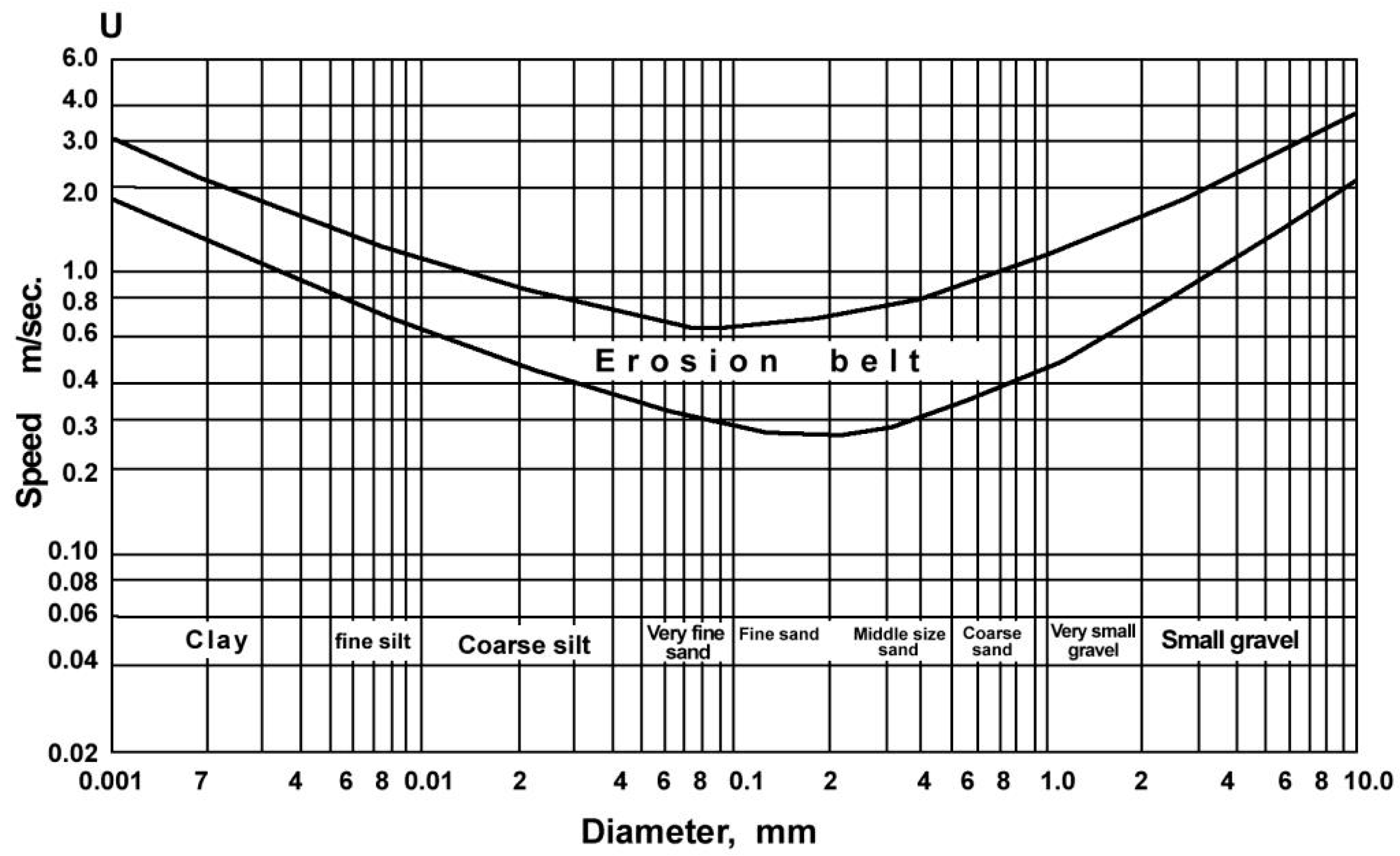
The absence of clayey-limy cementation in the sandy-silty and gravelly materials has heightened susceptibility to erosion. Laboratory experiments have demonstrated that gravel-sized materials can be transported at speeds exceeding 1 m/sec, while silts and sands are transported at speeds ranging from 0.6 to 0.4 m/sec (
Figure 5). The easy transportability of sandy and silty materials by runoff and/or overland flow has led to the development of gully erosion [
22].
In
Figure 5, it can be observed that materials between coarse silt and coarse sand are transported at speeds ranging from 0.6 to 0.3 m/s. It is understood that the hardest eroded material consists of clay particles that attract each other with negative electrical force and coarse gravel-sized material, which is difficult to erode and transport. This graph clearly illustrates why gully development occurs on sandy-silty material.
The main materials and soil samples presented in
Table 1 were taken from colluvial deposits at locations including Salihli (1,2,3); Kurşunlu (4,5,6,7,8); Kula (10,11,12,13); Kurudere (14,15); and Damatlı (16). Their colors—grey, reddish, brown, and yellowish—depend on their weathering levels and the location from which they were transported. Some physical and chemical soil characteristics from parent materials of five different locations where colluvial soils formed are shown in Tables 1 and 2. The pH values of the soils ranged from 4.1 to 8.3, with a mean value of 6.988. Most pH values (10 samples) were found to be over 7, indicating a neutral to slightly alkaline reaction. As for the EC values of the soil samples, they varied between 0.21% and 3.89%, with a mean value of 0.7081%. The results suggest that most soils are slightly salty to moderately salty, with two soil samples being strongly salty. The CaCO
3 (lime) content of the soil samples ranged from 2.4% to 8.8%, with a mean value of 4.331%. These values indicate that the soils are calcareous to moderately calcareous. The SOM values varied between 0.05% and 11%, with a mean value of 1.3781%. Only two soil samples had moderate to high SOM content, while most had a very low amount. The CEC values of the soil samples ranged between 3 and 20, with a mean value of 8.8062. This value range suggests that the soils are low in CEC. The soil texture classes of the samples differed. Nine of the soil samples had a texture class of SL (Sandy Loam), three had L (Loam), three had CL (Clayey Loam), one had SCL (Sandy Clayey Loam), and one had LS (Loamy Sand).
The K levels of the soil samples varied between 0.07 and 0.7 cmolc kg-1, with a mean value of 0.1794 cmolc kg-1, indicating very low to low amounts of K in the soils. The Ca level ranged from 1.00 cmolc kg-1 to 12.30 cmolc kg-1, with a mean value of 5.4438 cmolc kg-1, suggesting soils had a range from very low to medium Ca levels. The Mg level differed among the soil samples, ranging from 0.05 to 3.00 cmolc kg-1, with a mean value of 1.3069 cmolc kg-1, indicating low to medium levels of Mg in the soils. The Na values varied between 0.00 and 6.90 cmolc kg-1, with a mean value of 0.9395. Most soil samples had low to moderate Na levels, while three had very high amounts of Na.
Table 1.
Some physical and chemical analysis of the parent materials and soils taken from around Salihli and Turgutlu.
Table 1.
Some physical and chemical analysis of the parent materials and soils taken from around Salihli and Turgutlu.
| No |
Horizon |
pH |
EC |
CaCO3
% |
SOM
% |
K
cmolc kg-1
|
Ca cmolc kg-1
|
Mg cmolc kg-1
|
Na cmolc kg-1
|
CEC
cmolc kg-1
|
S
% |
Si
% |
C
% |
Texture |
| 1 |
C |
7.2 |
1.76 |
3.8 |
0.1 |
0.3 |
3.6 |
3.0 |
2.4 |
9.5 |
44 |
34 |
22 |
CL |
| 2 |
C |
7.5 |
0.26 |
5.2 |
0.7 |
0.1 |
12.3 |
0.7 |
0.2 |
9.7 |
65 |
18 |
17 |
SL |
| 3 |
A |
7.6 |
0.28 |
8.8 |
0.6 |
0.1 |
11.2 |
1.2 |
0.1 |
8.4 |
55 |
14 |
31 |
SL |
| 4 |
C |
6.9 |
0.28 |
3.2 |
0.05 |
0.1 |
4.7 |
2.2 |
0.5 |
11.0 |
66 |
14 |
20 |
SL |
| 5 |
A |
7.3 |
0.35 |
4.0 |
4.3 |
0.7 |
10.1 |
1.8 |
0.1 |
20.0 |
55 |
16 |
29 |
SL |
| 6 |
C1 |
7.1 |
0.62 |
3.6 |
0.3 |
0.2 |
8.9 |
1.6 |
0.3 |
14.0 |
53 |
14. |
33 |
SL |
| 7 |
C2 |
7.2 |
0.56 |
2.4 |
0.3 |
0.1 |
8.4 |
2.3 |
0.3 |
15.0 |
49 |
16 |
35 |
L |
| 8 |
C |
4.1 |
1.50 |
3.4 |
11 |
0.1 |
1.6 |
2.2 |
0.5 |
9.0 |
52 |
21 |
27 |
SCL |
| 9 |
Cm |
6.8 |
0.19 |
3.8 |
0.7 |
0.1 |
2.3 |
1.2 |
0.2 |
7.0 |
63 |
13 |
24 |
SL |
| 10 |
C |
7.5 |
3.89 |
2.6 |
0.5 |
0.3 |
4.6 |
2.23 |
6.9 |
8.3 |
40 |
24 |
36 |
L |
| 11 |
C |
8.1 |
0.26 |
3.8 |
0.9 |
0.1 |
6.0 |
1.43 |
0.5 |
5.0 |
49 |
14 |
37 |
L |
| 12 |
A |
8.3 |
0.47 |
4.2 |
0.4 |
0.1 |
1.0 |
0.2 |
2.7 |
5.0 |
53 |
15 |
32 |
SL |
| 13 |
C |
7.6 |
0.20 |
6.8 |
0.4 |
0.3 |
7 |
0.4 |
0.1 |
4.0 |
85 |
7 |
8 |
LS |
| 14 |
C |
6.1 |
0.25 |
4.8 |
0.6 |
0.1 |
1.8 |
0.3 |
0 |
8.0 |
17 |
55 |
28 |
SL |
| 15 |
C |
6.0 |
0.25 |
4.1 |
0.6 |
0.1 |
1.0 |
0.05 |
0.1 |
4.0 |
7 |
63 |
30 |
SL |
| 16 |
C |
6.5 |
0.21 |
4.8 |
0.6 |
0.07 |
2.6 |
0.1 |
0,1 |
3.0 |
9 |
71 |
20 |
SL |
Statistical analysis encompassed the examination of 12 distinct parameters within the collected samples. Initially, key statistical measures including variance (V), standard deviation (SD), coefficient of variation (CV), coefficient of skewness (SC), and kurtosis (K) were computed and presented in
Table 2. Subsequently, a principal component analysis (PCA) was conducted on the 12 variables derived from 16 samples, unveiling the underlying variability within the dataset.
Table 2.
Descriptive statistics of the soil physical and chemical properties. V: Variance; SD: standard deviation; CV: coefficient of variation; SC: skewness coefficient; K: kurtosis;.
Table 2.
Descriptive statistics of the soil physical and chemical properties. V: Variance; SD: standard deviation; CV: coefficient of variation; SC: skewness coefficient; K: kurtosis;.
| |
Minimum |
Maximum |
Mean |
SD |
Variance |
Skewness |
Kurtosis |
| pH |
4,1 |
8,30 |
6,988 |
0,9939 |
0,988 |
-1,664 |
4,059 |
| EC |
0,19 |
3,89 |
0,7081 |
0,96731 |
0,936 |
2,769 |
8,192 |
| CaCO3 |
2,4 |
8,80 |
4,331 |
1,5852 |
2,513 |
1,714 |
3,587 |
| SOM |
0,05 |
11,00 |
1,3781 |
2,74584 |
7,540 |
3,326 |
11,464 |
| K |
0,07 |
0,70 |
0,1794 |
0,16126 |
0,026 |
2,545 |
7,287 |
| Ca |
1,00 |
12,30 |
5,4438 |
3,78963 |
14,361 |
0,480 |
-1,123 |
| Mg |
0,05 |
3,00 |
1,3069 |
0,93572 |
0,876 |
0,102 |
-1,212 |
| Na |
0,00 |
6,90 |
0,9375 |
1,78246 |
3,177 |
2,896 |
8,949 |
| CEC |
3,00 |
20,00 |
8,8062 |
4,54598 |
20,666 |
1,020 |
1,087 |
| Sand |
7,0 |
85,00 |
47,62 |
20,998 |
440,917 |
-0,703 |
0,418 |
| Silt |
7,0 |
71,00 |
25,56 |
19,691 |
387,729 |
1,541 |
1,083 |
| Clay |
8,0 |
37,00 |
26,81 |
7,867 |
61,896 |
-0,859 |
0,568 |
Within the framework of PCA, components boasting eigenvalues surpassing 1 are deemed principal components. This investigation has revealed that the first four principal components, characterized by eigenvalues (factor loading/eigenvalue) exceeding 1, collectively account for 78.446% of the overall variation present in the dataset, as outlined in
Table 3. Notably, traits with factor loadings equal to or greater than 0.7 are considered influential in explaining dataset variability. In the context of component 1, Na stands out with a factor loading of 0.937, signifying its paramount contribution to the variability. Consequently, in component 1, Na and EC play pivotal roles; CEC, Ca, and K contribute significantly to component 2; sand and silt dominate in component 3; while pH and SOM take center stage in component 4 (
Table 3). It is noteworthy that almost all properties exhibit significance in elucidating dataset variability.
Moving forward, the next phase involved the calculation of Pearson correlation coefficients for each principal component, as detailed in
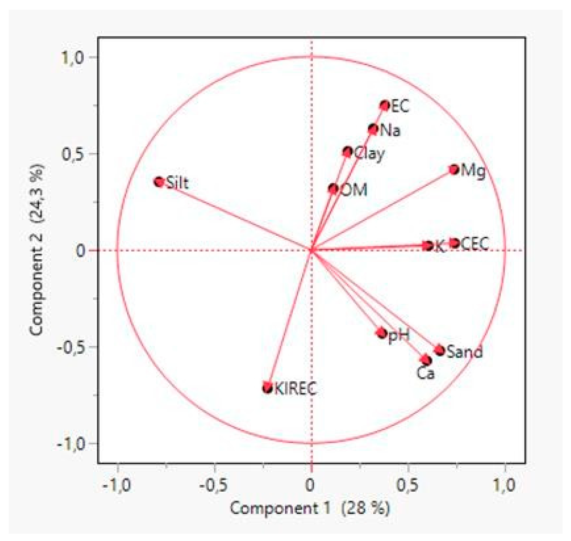
Table 4. Notably, the table highlights prominent correlations, with Silt and Sand leading at 0.927, followed by EC and Na at 0.901, and pH and SOM at -0.711. To visually represent the impact of the two most influential principal components, accounting for 28% and 24.3% of the variance, biplot graphs were generated post-Principal Component Analysis, and these are illustrated in
Figure 5.
Table 4.
Pearson Correlation coefficients of soil properties.
Table 4.
Pearson Correlation coefficients of soil properties.
| pH |
EC |
CaCO3 |
SOM |
K |
Ca |
Mg |
Na |
CEC |
Sand |
Silt |
Clay |
| pH |
1 |
-0,067 |
0,203 |
-,711**
|
0,200 |
0,446 |
-0,067 |
0,257 |
0,018 |
0,359 |
-0,419 |
0,091 |
| EC |
-0,067 |
1 |
-0,400 |
0,158 |
0,229 |
-0,155 |
0,543*
|
0,901**
|
0,063 |
-0,078 |
-0,036 |
0,297 |
| CaCO3 |
0,203 |
-0,400 |
1 |
-0,148 |
-0,064 |
0,361 |
-0,471 |
-0,352 |
-0,306 |
0,178 |
-0,038 |
-0,380 |
| SOM |
-0,711** |
0,158 |
-0,148 |
1 |
0,157 |
-0,142 |
0,251 |
-0,120 |
0,208 |
0,067 |
-0,091 |
0,048 |
| K |
0,200 |
0,229 |
-0,064 |
0,157 |
1 |
0,327 |
0,311 |
0,180 |
0,590*
|
0,223 |
-0,222 |
-0,040 |
| Ca |
0,446 |
-0,155 |
0,361 |
-0,142 |
0,327 |
1 |
0,189 |
-0,209 |
0,552*
|
0,494 |
-0,510*
|
-0,042 |
| Mg |
-0,067 |
0,543*
|
-0,471 |
0,251 |
0,311 |
0,189 |
1 |
0,334 |
0,591*
|
0,304 |
-0,421 |
0,243 |
| Na |
0,257 |
0,901** |
-0,352 |
-0,120 |
0,180 |
-0,209 |
0,334 |
1 |
-0,083 |
-0,051 |
-0,074 |
0,322 |
| CEC |
0,018 |
0,063 |
-0,306 |
0,208 |
0,590*
|
0,552*
|
0,591*
|
-0,083 |
1 |
0,269 |
-0,387 |
0,250 |
| Sand |
0,359 |
-0,078 |
0,178 |
0,067 |
0,223 |
0,494 |
0,304 |
-0,051 |
0,269 |
1 |
-0,927**
|
-0,348 |
| Silt |
-0,419 |
-0,036 |
-0,038 |
-0,091 |
-0,222 |
-,510*
|
-0,421 |
-0,074 |
-0,387 |
-0,927** |
1 |
-0,028 |
| Clay |
0,091 |
0,297 |
-0,380 |
0,048 |
-0,040 |
-0,042 |
0,243 |
0,322 |
0,250 |
-0,348 |
-0,028 |
1 |
Figure 5.
Principle component PCA biplot.
Figure 5.
Principle component PCA biplot.
3. Discussion
In the study area, all colluvial are derived from gneisses and mica schists originating from the Boz Mountains. These colluvial exhibit varying degrees of weathering and colors. The steep slope gradient facilitates the continuous downhill movement of sand and gravel materials due to gravitational forces. Additionally, increased erosion and debris flow on the slopes facilitate the transportation of plant seeds, resulting in bare land with minimal vegetation cover [
23].
The sandy texture of the colluvial deposit is a consequence of the weathering products of mica schist, gneiss, and quarzitic schist. Specifically, sand particles predominantly result from the weathering of gneiss and mica schist, rich in quartzite minerals. Clay is derived from the weathering of mica minerals, while silt primarily originates from the weathering of feldspar [
24].
Generally, sandy soils or deposits tend to have low plant nutrient content due to the higher presence of silica compared to feldspar and mica minerals. However, colluvial deposits create a conductive habitat for the growth of taproot trees such as grape, fig, and Calabrian pine. These trees thrive in colluvial deposits as their roots easily access the deep layers, contributing to the uptake of sufficient plant nutrients [
25].
The pH values of most soil samples are over 7, indicating a neutral or slightly alkaline reaction (Tables 1 and 2). Soil pH plays a crucial role in nutrient solubility and availability to plants. Optimal plant development requires different pH values, and the study area exhibits conditions suitable for various plants [
26].
Apart from two soils with strong salinity characteristics, most soils in the study area show low electrical conductivity (EC) values, ranging from slightly salty to moderately salty (Tables 1 and 2). While most colluvial are generally suitable for agricultural use without significant salinity issues, attention should be given to strongly saline colluvial, which may severely limit the growth of salt-sensitive plant species [
27].
Cation exchange capacity (CEC) values are uniformly low in all soils, ranging from 3 to 20. The low CEC may be attributed to the low organic matter content in most soil samples, as organic materials can significantly increase the soil's absorption capacity [
28].
The soils exhibit a wide range of sand, silt, and clay percentages, with sand dominating (47.67%), followed by silt (25.56%) and clay (26.81%). Most soils have a sandy loam texture, a crucial factor influencing soil properties such as permeability, infiltration, water capacity, and CEC [
29]. High levels of infiltration and leaching in areas with coarse texture cause the compounds that create salinity to be removed from the soil profile [
30].
Plant nutrients such as K, Ca, Mg, and the nonessential but influential cation Na are found at low levels in the examined soils. Previous studies have reported negative relationships between exchangeable K content and soil sand content, as well as positive relationships with clay, silt, CEC, and organic matter levels [
31,
32]. This may affect the growth of plants with requirements favorable by these cations.
4. Conclusions
Land capability class IV is prevalent in the gently undulating and flat regions at the upper reaches of the Boz Mountains. The primary production area for grapevines, olives, and figs is characterized by colluvial deposits, dejection fans, and cones falling under the V class land. These areas extend along the lowland edge of the Boz Mountains and Gediz River, serving as the main agricultural zones for grapevines, olives, and figs. Notably, sandy alluvial fans are the exclusive production region for seedless sultana grapes, not only within Turkiye but also globally.
The Boz Mountains and colluvial deposits frequently witness the misuse of land. For instance, forested areas classified as class VII are converted into agricultural lands to cultivate cereals, vegetables, and fruits. This transformation is particularly evident in sloping areas comprised of exposed mica schists and gneisses, categorized as rocky land in class VIII. Consequently, the agricultural regions within the sloping parts of colluvial deposits undergo intense erosion.
The formation of diverse gullies in the Boz Mountains over different periods is closely tied to geomorphological evolution, primarily influenced by vertical faulting movements and sandy colluvial deposits. Each faulting movement intensifies the altitudinal difference between Gediz Graben and Boz Mountains horst, leading to increased erosion of weathered materials on the Boz Mountains and their accumulation on the northern slope. The resulting colluvial deposit, mainly composed of sandy and silty materials, undergoes deep dissection by running waters, with transported materials accumulating as dejection cones and fans in lowland areas toward Gediz Graben.
Generally, colluvial lands pose challenges for agriculture due to their slope, erosion risk, shallow soil, low soil organic matter (SOM), and limited nutritional capacity. Despite these limitations, plants such as olives and figs, known for their ability to thrive under challenging conditions and with minimal soil requirements, flourish due to the optimal climatic conditions of the region, contributing significantly to the local economy. Consequently, there is a need for increased research and studies focused on col- 375 luvial lands.
Acknowledgments
This study entitled “The Gully Erosion Formation and Its Rehabilitation on the Northern Slope of Boz Mountains and Southern Slope of Aydın Mountains and Southeastern Part of Burdur Basin, West of Anatolia, Turkey” was supported by the General Directorate of Combating Desertification and Erosion, Agriculture and Forestry Ministry of Turkey.
Declaration of Competing Interest
The authors declare that they have no known competing financial interest or personel relationships that could have appeared to influence to work in this paper.
References
- Güçdemir, İ.; Sönmez, B. The importance of doing soil analysis. Turkish Journal of Agriculture 2008, 12, 28–30. [Google Scholar]
- Kuşat, N. Green economy for green sustainability: advantages and disadvantages. Türkiye review. Yaşar University E-Journal. 2013, 8, 4896–4916. [Google Scholar]
- Kingsley, J.; Akpan-ldiok, A.U.; Okon, A.E.; Penizek, V. Mineralogical properties of soil development from colluvial deposits of southern Nigeria. Bulgarian Journal of Agricultural Science 2020, 26, 605–611. [Google Scholar]
- Yassoglou, N.; Tsadilas, C.; Kosmas, C. Colluvial Soils. In: The Soils of Greece. World Soils Book Series. 2017. Springer, Cham. [CrossRef]
- Dotterweich, M. The history of soil erosion and fluvial deposits in small catchments of central Europe: Deciphering the long-term interaction between humans and the environment A review. Geomorphology 2008, 101, 192–208. [Google Scholar] [CrossRef]
- Miera, J.J.; Henkner, J.; Schmidt, K.; Fuchs, M.; Scholten, T.; Kühn, P.; Knopf, T. Neolithic settlement dynamics derived from archaeological data and colluvial deposits between the Baar region and the adjacent low mountain ranges, southwest Germany. E&G Quaternary Science Journal 2019, 68, 75–93. [Google Scholar]
- Scherer, S.; Deckers, K.; Dietel, J.; Fuchs, M.; Henkner, J.; Höpfer, B.; Junge, A.; Kandeler, E.; Lehndorff, E.; Leinweber, P.; et al. What’s in a colluvial deposit? Perspectives from archaeo-pedology. Catena 2021, 198, 105040. [Google Scholar] [CrossRef]
- Atalay, İ. Applied Climatology. Book, 2022, (3th Pub). Meta Basım, İzmir.
- Akkök, R. Metamorphism conditions in gneisses and schists of the Menderes massif, Alaşehir-Manisa. Turkey Geol. Kur. 1981 Bulletin, 24(1).
- Ketin, İ. A general overview of Türkiye's geology: İ. Only. Univ. Pole. 1983, No: 1259. İstanbul.
- Şengör, C.A.M. Fundamentals of Turkey's neotectonics. Turkish. Jeol. Exchange rate. 1980, Ankara.
- Şengör, A.M.C. and Yılmaz, Y. Evolution of the Tethys in Turkey: An approach from the perspective of plate tectonics: Turkish Geol. Exchange rate. Geosciences, 1983.
- Atalay, İ. Geomorphology of Turkey. Book. 2017. (3rd Ed.). Meta Basım, İzmir.
- Koçman, A. Structural geomorphology and evolution of the Izmir-Bozdağlar region. Aegean Geog. Journal 1985, 3, 63–86. [Google Scholar]
- Atalay, İ. A New approach to the land capability classification: Case Study of Turkey. Procedia Environmental Sciences 2016, 32, 264–274. [Google Scholar] [CrossRef]
- Day, P.R. Particle fractionation and particle size analysis. p. 545-567. In Methods of soil analysis. American Society of Agronomy, 1982. Soil Science Society of America, Madison, Wisconsin, USA.
- Jackson, M.C. Soil chemical analysis. Prentice Hall of India Private’Limited, 1967. New Delhi.
- Olsen, S.R. and Sommers, E.L. Phosphorus soluble in sodium bicarbonate. p. 404-430. In Page, A.L. Miller, P.H., Keeney, D.R. (eds). Methods of soil analysis. Part 2. Chemical and microbiological properties. American Society of Agronomy, 1982. Soil Science Society of America, Madison, Wisconsin, USA.
- Kacar, B. Physical and chemical soil analysis. Nobel Publications and Distribution, 2016. Ankara, Turkey. (In Turkish).
- Yurtsever, N. Experimental statistics methods. Soil-Fertilizer Research Institute Publications. 1984. N0:121, Techniques Publication N°56. Republic of Turkey, Ministry of Agriculture, General Directorate of Rural Service, Ankara, Turkey.
- Jolliffe, I.T.; Cadima, J. Principle component analysis. A revive and recent developments. Philosophical transactions, series A, mathematical, Physical and Engineering Sciences 2016, 374, 20150202. [Google Scholar]
- Bursalı, S. Scour problem in cohesionless soils. DSİ Teknik Bül. 1971.Sayı 23.
- Cheng, D.; Iqbal, J.; Gao, C. Debris flow gully classification and susceptibility assessment model construction. Land 2023, 12, 571. [Google Scholar] [CrossRef]
- Oni, S.O.; Olatunji, A.S. Depositional environments signatures, maturity and source weathering of Niger Delta sediments from an oil well in southeastern Delta State, Nigeria. Eurasian J Soil Sci 2017, 6, 259–274. [Google Scholar] [CrossRef]
- Schoonover, J.E.; Crim, J.F. An Introduction to soil concepts and the role of soils in watershed management. Journal of Contemporary Water Research 2015, 154, 47. [Google Scholar] [CrossRef]
- Barrow, N.J.; Hartemink Alfred, E. The effects of pH on nutrient availability depend on both soils and plants. Plant Soil 2023, 487, 21–37. [Google Scholar] [CrossRef]
- Balasubramaniam, T.; Shen, G.; Esmaeili, N.; Zhang, H. Plants’ Response Mechanisms to Salinity Stress. Plants 2023, 12, 2253. [Google Scholar] [CrossRef] [PubMed]
- Atalay, İ. Soil formation, classification and geograph /Toprak oluşumu, sınıflandırılması ve coğrafyası. 3. Baskı, Meta Publication. 2006. Bornova, İzmir.
- Warrence, N. J., Bauder, J. W. and Pearson, E. K. Basic of salinity and sodicity effects on soil physical properties, 2002. http://www.iav.ac.ma/agro/dss/chimieso/basics_salinity.htm (Accessed: 17 December 2023).
- Kantarcı, M. D. Soil Science/ Toprak ilmi. İ. Ü. Publications, No: 3444, O.F. Publication No: 387. 1987. İstanbul.
- Atalay, İ. Nutrient statu of the Gediz Basin Rendzina soils and their relationship with some soil properties/ Gediz havzası Rendzina topraklarının besin elementi durumu ve bunların bazı toprak özellikleri ile ilişkileri. Ege Üniv. Zir. Fak. Derg. 1988, 25, 173–184. [Google Scholar]
- Çimrin, K.M.; Boysan, S. Van Region Nutritional Element States of Agricultural Land and Their Relationship with Some Soil Properties/ Van Yöresi Tarım Topraklarının Besin Elementi Durumları ve Bunların Bazı Toprak Özellikleri ile İlişkileri. Yüzüncü Yıl Üniversitesi, Ziraat Fakültesi, Tarım Bilimleri Dergisi (J. Agric. Sci.) 2006, 16, 105–111. [Google Scholar]
|
Disclaimer/Publisher’s Note: The statements, opinions and data contained in all publications are solely those of the individual author(s) and contributor(s) and not of MDPI and/or the editor(s). MDPI and/or the editor(s) disclaim responsibility for any injury to people or property resulting from any ideas, methods, instructions or products referred to in the content. |
© 2023 by the authors. Licensee MDPI, Basel, Switzerland. This article is an open access article distributed under the terms and conditions of the Creative Commons Attribution (CC BY) license (http://creativecommons.org/licenses/by/4.0/).
