Introduction:
The global perspective on flood control in urban environments recognizes the significant challenge of urban flooding and emphasizes an integrated approach. In my opinion Floods, while natural phenomena causing significant damage to the environment, people, and agriculture, also have benefits, such as providing water resources, supporting biodiversity, and contributing to agricultural productivity, especially in regions like the Horn of Africa, which is susceptible to various natural disasters. Public participation in flood prediction and management decisions in Brazilian cities, considering various drainage solutions and best practices, is essential for effective flood control, addressing public perceptions, and integrating expert knowledge with public understanding (Nascimento et al., 2008). Rapid urbanization in urban areas worldwide has led to increasing flood risks, necessitating a combination of flood control measures and comprehensive risk assessments to minimize economic losses and effectively manage flood risk through a holistic approach that considers various factors and integrates flood simulation and damage assessment (Li et al., 2016) .The integration of various tools, techniques, and data gathering methods enables a thorough assessment of flood risks, aiding in informed decision-making and the formulation of suitable flood management strategies (Rubio et al., 2020). With climate change and urbanization posing significant challenges, urban flooding, responsible for a substantial portion of climate disaster-related fatalities, necessitates sustainable stormwater management strategies, supported by urban flood models that employ quantitative and deep learning approaches, emphasizing the need for ongoing research to address comprehensive flood hazard mitigation (Qi et al., 2021).
Methodology:
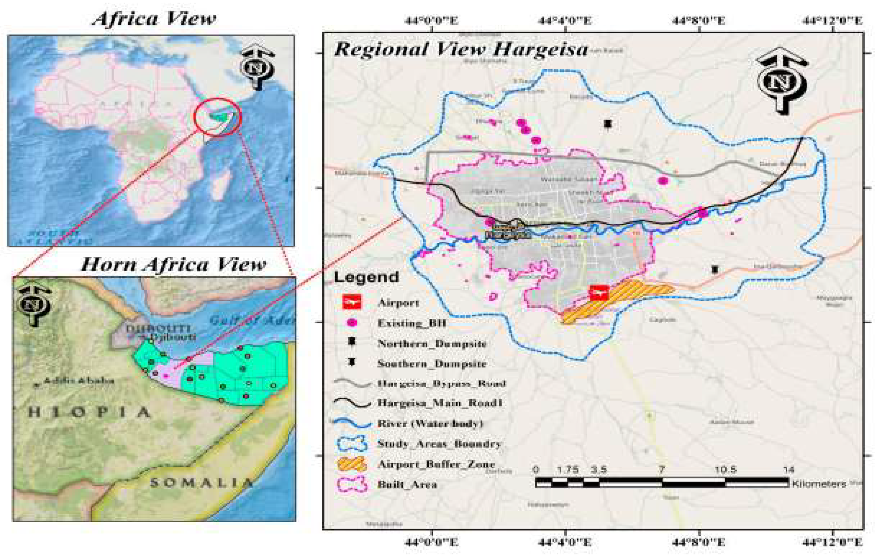
This study employed a community-based participatory research (CBPR) approach to investigate flood assessment and control measures in Hargeisa.
CBPR is a collaborative research approach that empowers community members to participate in all phases of the research process, from problem identification to data collection and interpretation (Nascimento et al., 2008).
A questionnaire survey was conducted with 83 community members residing in neighborhoods adjacent to the main valley that often experience flooding. The questionnaire explored respondents' perceptions of flood risks, their experiences with floods, and their preferred flood control measures.
Data Analysis:
The data collected was analyzed using descriptive statistics to summarize the respondents' responses. The frequency of flood occurrences, the perceived severity of flood impacts, and the most favored flood control measures were identified.
Results:
The findings reveal that floods have a significant impact on the lives and livelihoods of Hargeisa residents. Nearly 87% of respondents reported that floods have caused severe damage to their homes and property. Additionally, floods have disrupted transportation, damaged infrastructure, and exacerbated soil erosion.
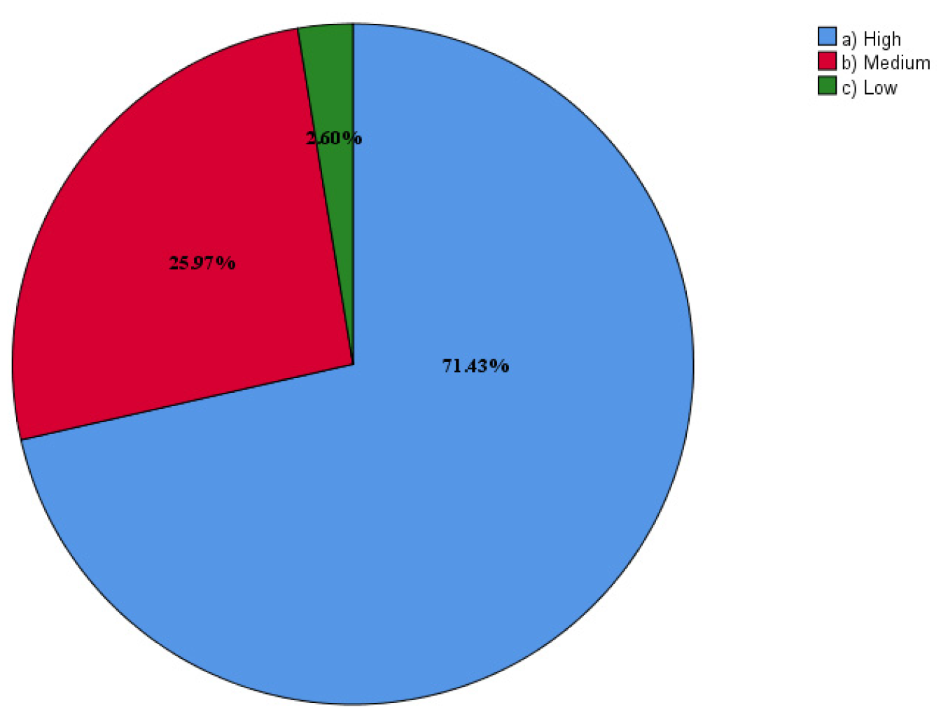
Figure 2.
The extent of the flood's impact on transportation.
Figure 2.
The extent of the flood's impact on transportation.
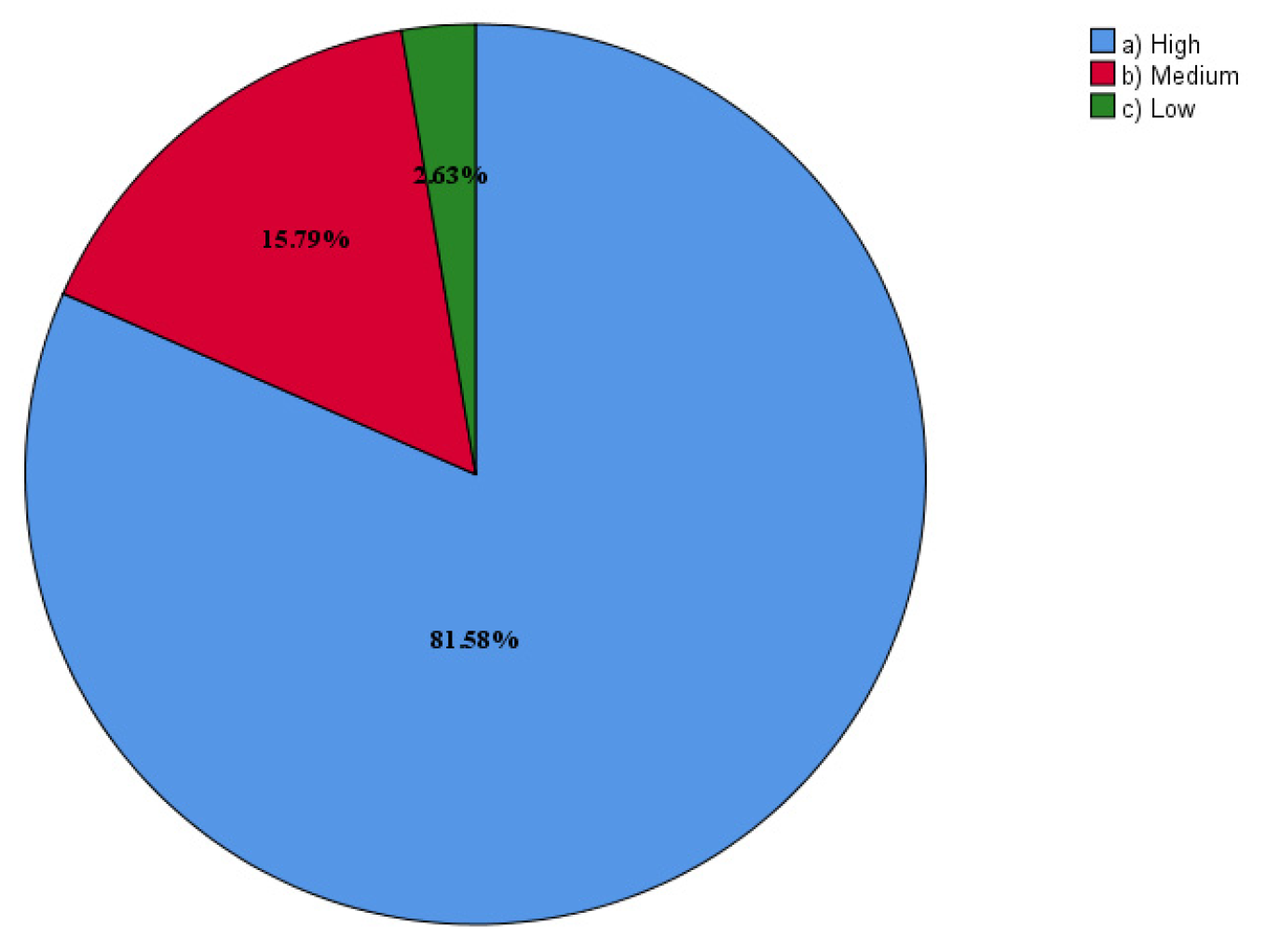
Figure 3.
the impact rate of soil erosion.
Figure 3.
the impact rate of soil erosion.
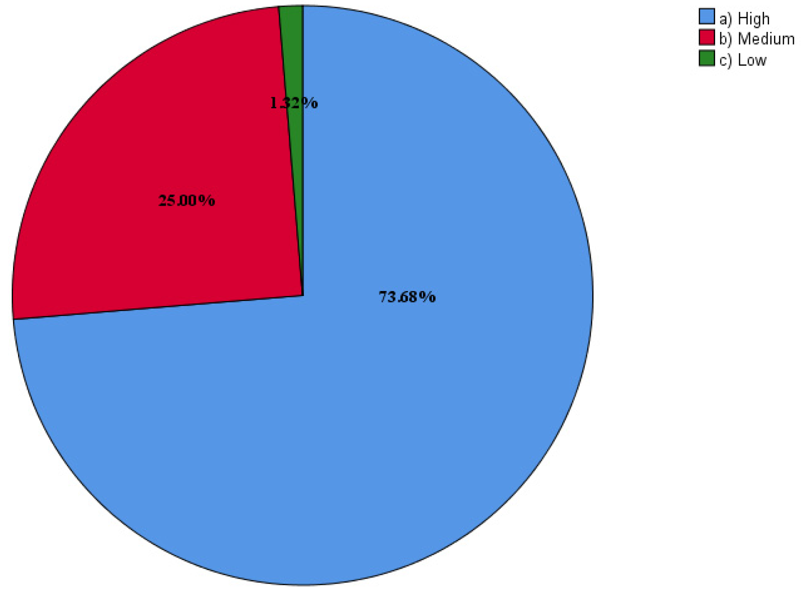
Figure 4.
The extent of the flood's impact on infrastructure.
Figure 4.
The extent of the flood's impact on infrastructure.
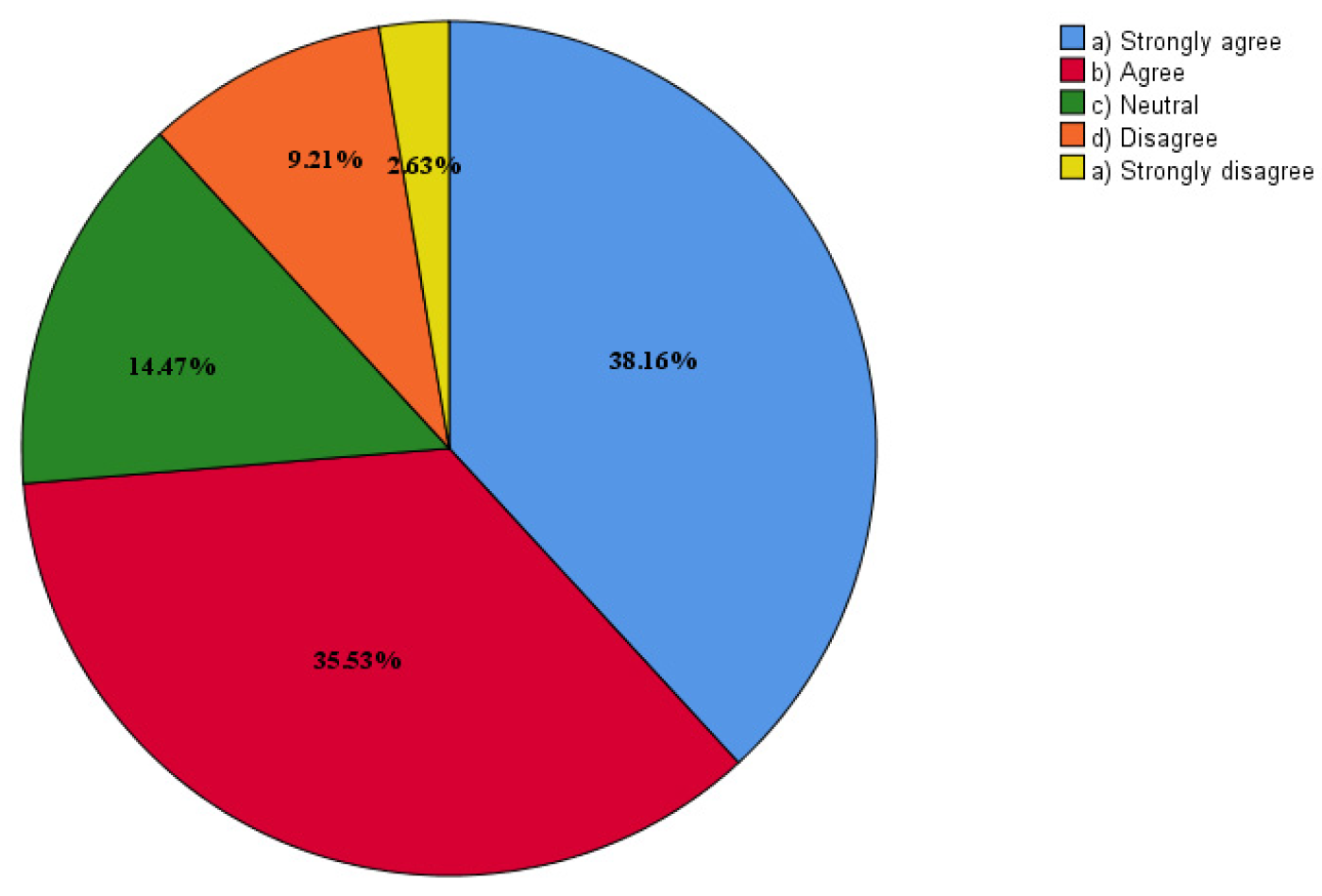
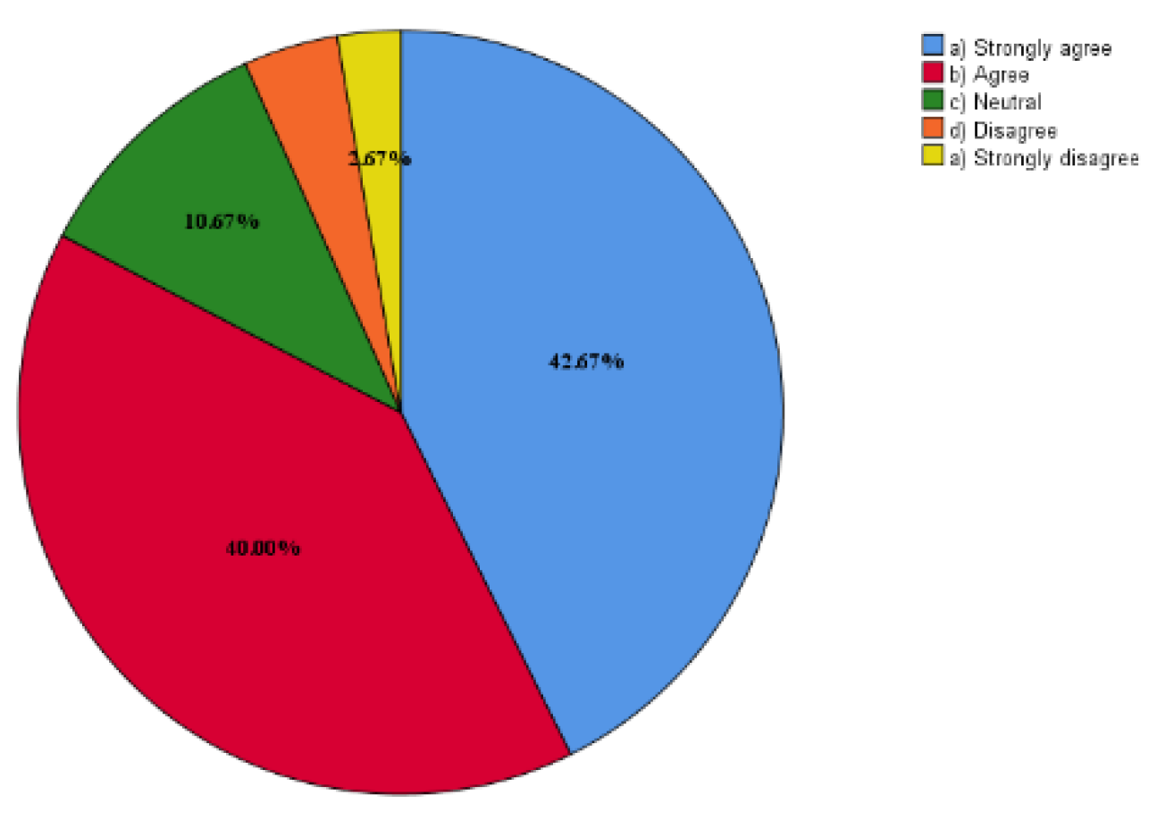
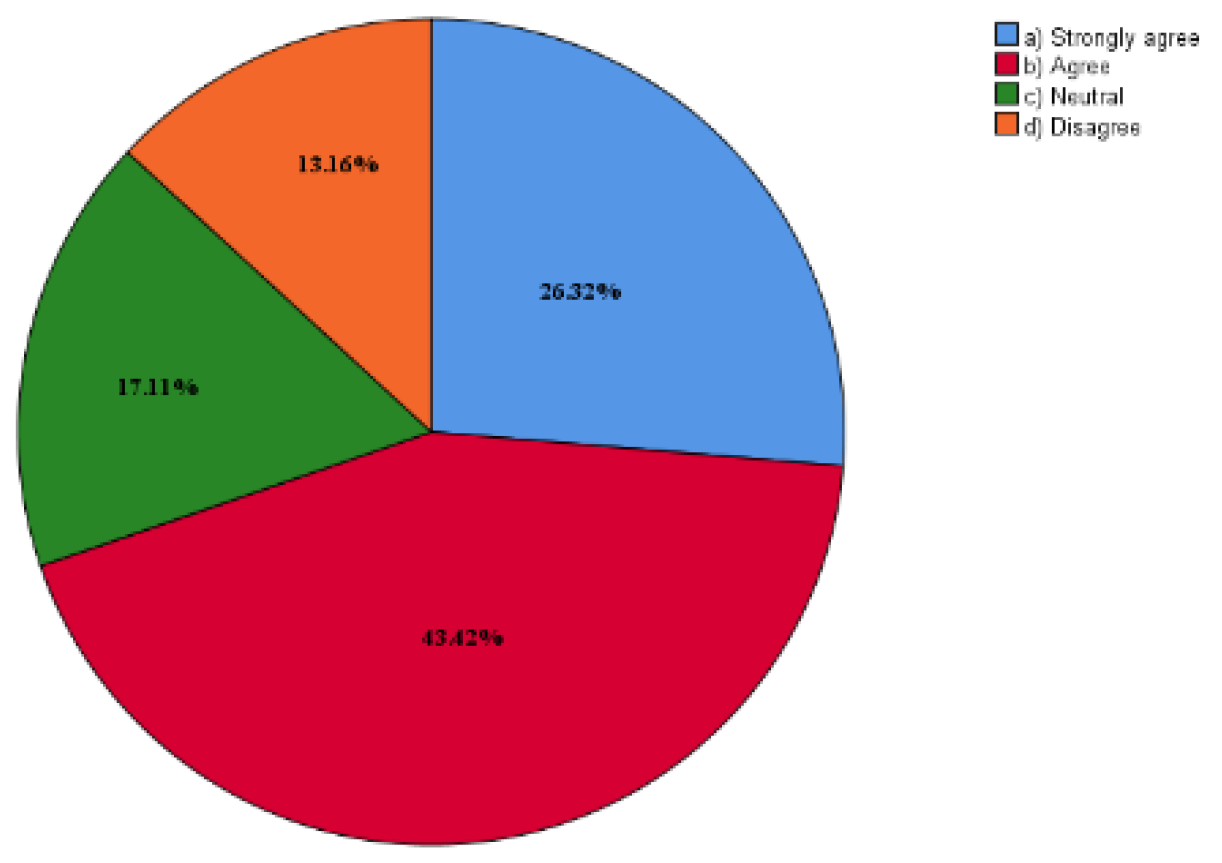
The questionnaire also revealed that respondents overwhelmingly support stream control, dam construction, and tree planting as effective flood control measures. These measures were perceived as being more cost-effective and sustainable than traditional hard engineering approaches, such as concrete dams and levees.
Figure 5.
Planting more trees in the valleys and waterways inside and outside the city will reduce the potential for flooding.
Figure 5.
Planting more trees in the valleys and waterways inside and outside the city will reduce the potential for flooding.
Figure 6.
Streams are the main source of floods, if streams are controlled the floods will stop completely by constructing check dams.
Figure 6.
Streams are the main source of floods, if streams are controlled the floods will stop completely by constructing check dams.
Figure 7.
Making the valley one big dam is the most important solution for flood control.
Figure 7.
Making the valley one big dam is the most important solution for flood control.
Conclusion:
The findings of this study highlight the importance of community engagement in flood assessment and control efforts. Community members are often the most knowledgeable about local flooding patterns and can provide valuable insights into effective mitigation strategies. CBPR can foster a sense of ownership and responsibility among community members, leading to more sustainable and effective flood management initiatives.
Based on the study's findings, the following recommendations are proposed for flood risk management in Hargeisa:
Develop a comprehensive flood risk management plan that incorporates community participation and a combination of hard and soft engineering measures.
Implement stream control measures, such as check dams and channelization, to regulate water flow and reduce flood risks.
Construct small dams to store excess floodwater and release it in a controlled manner.
Encourage tree planting to increase infiltration capacity and reduce surface runoff.
Improve drainage infrastructure to facilitate the efficient
References
- de Moel, H., Jongman, B., Kreibich, H., Merz, B., Penning-Rowsell, E., & Ward, P. J. (2015). Flood risk assessments at different spatial scales. Mitigation and Adaptation Strategies for Global Change, 20(6). [CrossRef]
- Esmaiel, A., Abdrabo, K. I., Saber, M., Sliuzas, R. V., Atun, F., Kantoush, S. A., & Sumi, T. (2022). Integration of flood risk assessment and spatial planning for disaster management in Egypt. Progress in Disaster Science, 15. [CrossRef]
- Fileni, F. de M., Costa, M. E. L., & Alves, C. de M. A. (2019). The application of lids in savanna region for mitigation of flooded areas. Revista Brasileira de Recursos Hidricos, 24. [CrossRef]
- Gao, M., Wang, Z., & Yang, H. (2022). Review of Urban Flood Resilience: Insights from Scientometric and Systematic Analysis. In International Journal of Environmental Research and Public Health (Vol. 19, Issue 14). [CrossRef]
- Huang, C. L., Hsu, N. S., Wei, C. C., & Luo, W. J. (2015). Optimal spatial design of capacity and quantity of rainwater harvesting systems for urban flood mitigation. Water (Switzerland), 7(9). [CrossRef]
- Lama, G. F. C., Giovannini, M. R. M., Errico, A., Mirzaei, S., Padulano, R., Chirico, G. B., & Preti, F. (2021). Hydraulic efficiency of green-blue flood control scenarios for vegetated rivers: 1D and 2D unsteady simulations. Water (Switzerland), 13(19). [CrossRef]
- Li, C., Cheng, X., Li, N., Du, X., Yu, Q., & Kan, G. (2016). A framework for flood risk analysis and benefit assessment of flood control measures in Urban Areas. International Journal of Environmental Research and Public Health, 13(8). [CrossRef]
- Liao, K. H. (2012). A theory on urban resilience to floods-A basis for alternative planning practices. Ecology and Society, 17(4). [CrossRef]
- Liu, Y. C., & Cheng, C. L. (2014). A Solution for Flood Control in Urban Area: Using Street Block and Raft Foundation Space Operation Model. Water Resources Management, 28(14). [CrossRef]
- Nascimento, N.; Guimaraes, E.; Mingoti, S. a.; Moura, N.; Faleiro, R. Assessing public perception of flood risk and flood control measure in urban areas. In Proceedings of the 11th International Conference on Urban Drainage, Edinburgh, Scotland, UK, 25–29 November 2007. [Google Scholar]
- Qi, W., Ma, C., Xu, H., Chen, Z., Zhao, K., & Han, H. (2021). A review on applications of urban flood models in flood mitigation strategies. In Natural Hazards (Vol. 108, Issue 1). [CrossRef]
- Rubio, C. J., Yu, I. S., Kim, H. Y., & Jeong, S. M. (2020). Index-based flood risk assessment for Metro Manila. Water Science and Technology: Water Supply, 20(3). [CrossRef]
- Sarmah, T., & Das, S. (2018). Urban flood mitigation planning for Guwahati: A case of Bharalu basin. Journal of Environmental Management, 206. [CrossRef]
- Sefton, C., Sharp, L., Quinn, R., Stovin, V., & Pitcher, L. (2022). The feasibility of domestic raintanks contributing to community-oriented urban flood resilience. Climate Risk Management, 35. [CrossRef]
- Wu, Z., Zhou, Y., Wang, H., & Jiang, Z. (2020). Depth prediction of urban flood under different rainfall return periods based on deep learning and data warehouse. Science of The Total Environment, 716, 137077. [CrossRef]
- Zhu, S., Li, D., Feng, H., & Zhang, N. (2023). The influencing factors and mechanisms for urban flood resilience in China: From the perspective of social-economic-natural complex ecosystem. Ecological Indicators, 147. [CrossRef]
|
Disclaimer/Publisher’s Note: The statements, opinions and data contained in all publications are solely those of the individual author(s) and contributor(s) and not of MDPI and/or the editor(s). MDPI and/or the editor(s) disclaim responsibility for any injury to people or property resulting from any ideas, methods, instructions or products referred to in the content. |
© 2024 by the authors. Licensee MDPI, Basel, Switzerland. This article is an open access article distributed under the terms and conditions of the Creative Commons Attribution (CC BY) license (http://creativecommons.org/licenses/by/4.0/).
