Preprint
Review

The Cultural Ecohydrogeology of Mediterranean-Climate Springs: A Global Review with Case Studies

Altmetrics

Downloads

356

Views

220

Comments

0

A peer-reviewed article of this preprint also exists.

Submitted:

12 January 2024

Posted:

12 January 2024

You are already at the latest version

Alerts
Abstract
Cultures in Mediterranean climate zones (MCZs) around the world have long been reliant on groundwater and springs as freshwater sources. While their ecology and cultural sustainability are recognized as critically important, inter-relationships between springs and culture in MCZs has received little attention. Here we augmented a global literature review with case studies in MCZ cultural landscapes to examine the intensity of cultural and socio-economic impacts on springs ecohydrogeology. MCZs are often oriented on the west and southern coasts in tectonically active landscapes, which control aquifer structure, the prevalence of westerly winds, and aridity, and generally expose associated habitats to harsh, afternoon sunlight. Cultural appreciation and appropriation of springs ranges widely, from their use as subsitence supplies to profound traditions, such as Greco-Roman nymphs, and Asian and Abrahamic spiritual cleansing and baptism. Commoditization of water resources for agriculture, industry (e.g., mining, water bottling, geothermal resorts), and urban needs is placing ever-increasing, non-sustainable demands on aquifers and springs. When economic values approach or exceed cultural values, these irreplaceable aquatic resources are degraded and lost. Sustainable stewardship of springs and the aquifers that support them are a little-recognized, but central conservation challenge for modern society facing global climate changes.
Keywords: 
Subject: Environmental and Earth Sciences  -   Environmental Science

1. Introduction

Human cultures develop and change in relation to the availability of limiting resources across personal to international-political societal scales (Solomon 2010). Fresh water, particularly that delivered by springs, has been a primary limiting resource in arid regions, such as those in Mediterranean climate zones (MCZs). Mediterranean climate is characterized by precipitation falling mostly during mild to cool winter months, with warm to hot summers, a high degree of seasonal and annual weather variability (Lionello 2012), and vegetation characterized by evergreen sclerophyllous shrub and woodland cover (Köppen 1898, 1900, 1918; Rundel et al. 2016). While the ecological and cultural sustainability of MCZs and springs around the world are recognized as critically important, the inter-relationships between springs and cultural development in MCZs have received little attention. In fact, a great number of recent works on hydrological, cultural, and historical books have little to no coverage of the topic of springs. But such study is of increasing importance, particularly in heavily populated, arid MCZs as global warming further exacerbates instability of weather and fresh groundwater availability, in turn affecting safety, food production, commerce, and politics (Li et al., 2012; Cramer et al., 2018; Mekonnen and Hoekstra, 2016; Cantonati et al. 2021).
The concept of Mediterranean-climate zone (MCZ) landscapes has been described from the individual and coupled perspectives of geography and climate and in relation to vegetation (Aschmann 1973; Blumler 2005, DiCastri and Mitrakos 1980; Mooney 1973; Schmida 1981; Specht 1969, 1981; Suc 1984; Lionello 2012). With an emphasis on vegetation, Köppen’s (1918) description of Mediterranean climate (Cs) was subsequently modified by Geiger (1954, 1961) and Trewartha (1961) and mapped by Walter et al. (1975) and others (Figure 1). Mediterranean climate has been subdivided into patterns of hot-, warm-, and (rare) cold-summer divisions (Csa, Csb, Csc, respectively) when coupled with rainfall-dominated wet winters, which have modest contributions from snow. Mediterranean climates most commonly develop on western coastlines in and around the Horse Latitudes through temperate Trade and Westerlies wind interactions between Hadley and Ferrel cells, which create high pressure subtropical ridges. Mediterranean Cs warm season climate has hot months with temperatures >22 °C and with a mean temperature >10 °C. Cold season minimum temperatures generally range from -3 to 18 °C and are mild to chilly.
Globally, springs are highly threatened ecosystems due to the coupled influences of intensifying human use and climate change worldwide (Cantonati et al. 2021; Stevens 2023). The main anthropogenic impacts and threats to the world’s spring ecosystems are reviewed in detail by Stevens et al. (2021). Of particular concern are: a) anthropogenic habitat degradation and loss, particularly related to water abstraction and livestock management (Barquín and Scarsbrook, 2008; Stevens et al. 2021); b) groundwater pollution and surface water eutrophication due to intensive agriculture practices and other causes (Fernández-Martínez et al., 2020; Martín et al., 2024); and c) climate change and associated increases in temperature and evapotranspiration (Gallart and Llorens, 2003; García-Ruiz et al., 2011), and decreased and more erratic precipitation (Cramer et al., 2018). All of these impacts lead towards aquifer degradation and depletion, which are becoming more serious under a warming climate in arid regions. As a consequence, demand for freshwater is likely to increase faster relative to supplies in Mediterranean-climate regions (Mekonnen and Hoekstra, 2016), potentially exacerbating direct impacts to human populations there and impacts related to other threats.
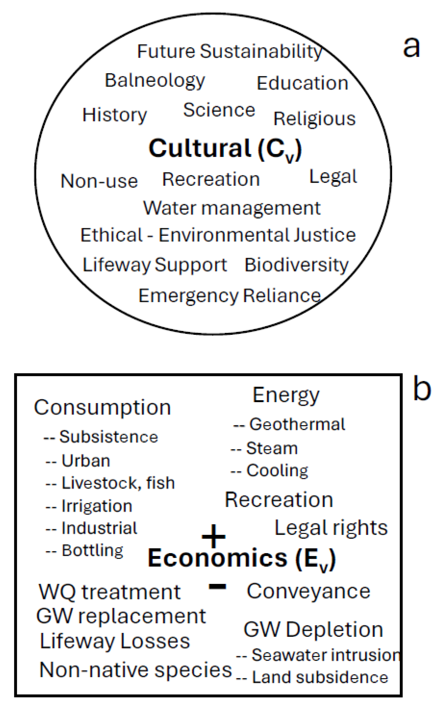
While analysis of the valuation and roles of springs in local and regional economics is still in its infancy, several recent studies and multiple environmental inventories indicate that as economic values approach cultural values, the ecological integrity of spring ecosystems are sacrificed (Mueller et al. 2017; Lewis et al. 2023). However, estimating the economic benefits of short-term exploitation against the costs of long-term loss of key ecosystem goods and services, or of ecosystem rehabilitation have yet to be fully enunciated.
Here we review the existing literature on cultural aspects of springs in MCZs. To augment this relatively sparse literature, we present multiple individual case studies of cultural history, use, and other relationships among MCZ landscapes and springs. We relate the natural characteristics of springs (ecohydrogeology, Cantonati et al. 2020a) and associated cultural uses in the five primary, as well as several lesser-known regions of the global Mediterranean biome. For clarity, each case study is organized with its own individual introduction, methods and materials, results and discussion sections, but all references are combined into the master bibliography. We examine the literature behind the hypothesis that economic valuation leads to ecosystem degradation, and test it qualitatively through the case studies. We use the information compiled here to frame hypotheses regarding human-spring cultural interactions across social scale, from that of the individual to synoptic/local community, and to the regional/political and global spheres. Such hypotheses may help guide future research in this multi-faceted field. We conclude with a description of the current and potential future cultural uses of, and threats to, Mediterranean climate springs in relation to a changing climate.

2. Overall Methods and Materials

2.1. Study area

Five primary temperate regions are described as having Mediterranean climate (Blondel and Aronson, 1999; Rundel et al., 2016; Figure 1), and springs are relatively abundant in most of those landscapes. The Euro-African Mediterranean basin forms the type locality for the climate and vegetation characterizing this biome, which occur broadly around the coasts and near-inland portions of the basin, except for eastern Tunesia, all of Egypt, and Libya (except for a small coast portion east of Banghazi). The Pacific West Coast of North America, from southern California to central Washington and inland into portions of the northern Great Basin Desert and northeastern Oregon have hot- to cool-summer Mediterranean climates (PRISM 2014). Central southern Chile, the Western Cape Region of South Africa, and southwestern and southern Australia make up the remaining three regions widely recognized as Mediterranean landscapes.
Several smaller landscapes in other temperate and some tropical regions also have Mediterranean climates. In the USA, the low- to middle-elevations on the southwest coast of the Big Island in Hawai’i, the Transition Valleys south of the Mogollon Rim in Arizona, the Wasatch Front in Utah and the Great Basin and Mojave deserts of North America in general, as well as portions of the northwestern coasts of Mexico on both sides of the Sea of Cortez lie in MCZs (PRISM 2014). A discontinuous belt of non-coastal Mediterranean climate exists from northwestern India and Pakistan into Afghanistan, and northern Iraq and Iran (e.g., Freitag 1971, 1982; Meusel 1971). The Canary Islands are sometimes described as having a Mediterranean climate, but have been classified as a hot desert to semiarid climate (Koppen BWh and BSh). In the tropics, lands in both central western Kenya and Ethiopia are mapped as having a Mediterranean climate, as is some of central Columbia and perhaps western Venezuela; however, we do not comment on these regions in this manuscript. Although not recognized as Mediterranean, the Galapagos Archipelago lies just south of the equator off the coast of Ecuador and has Mediterranean hot dry versus cooler moist seasons, with much variation related to oceanic current and atmospheric weather patterns (Weiner 1995; Trueman and d’Ozouville 2010).

2.2. Geography

Coastal Mediterranean climates exist due to tectonic geologic processes, and occur predominantly in west-facing coastal settings with adjacent piedmont and mountains to the east. Typical Mediterranean climate landscapes are arid due to global atmospheric and ocean circulation patterns, often with prevailing westerly winds and cool to cold ocean currents. Such landscapes often give rise to relatively small, short, and isolated river basins due to tectonic processes and timeframes. However, many small rivers occur in Mediterranean climates, providing freshwater for trading and fishing communities. Only three major rivers reach the sea in regions with Mediterranean climate. The 2000 km-long Columbia River drains 670,000 km2 including several landscapes with Mediterranean climate in the interior regions of the states of Oregon and Washington, reaching the ocean at the boundary of those two states in the Pacific Northwest of the USA. The 506 km-long Rhône River drains 98,000 km2 of the western Alps, Massif Central, and southeastern France, reaching the Mediterranean Sea south of Arles. The Murray-Darling River is 2560 km long, the longest in Australia, and its basin (1,061,470 km2) occupies one seventh of the continent. The Darling River is the longest tributary and heads in springs in the Snowy Mountains. It is joined by the Murrumbidgee and Murray rivers and flows southwest to the Indian Ocean in southeastern Australia. The mainstream has an average discharge of only 31 m3/s and rarely becomes intermittent. In general, rivers with larger, especially trans-biome, basins tend to be less predictable and more erratic in their flooding patterns tied to the climate (Johnson et al. 1995).
Mediterranean springs often emerge in proximity to coastlines, a phenomenon that may exacerbate multiple challenges to the sustainability of freshwater supplies management. Initial limited groundwater supplies in MCZs are easily compromised by aquifer overdraft, with consequent saline water incursion and land subsidence, as well as eutrophication of surface water supplies (Cantonati et al. 2020b, Fernández-Martínez et al., 2020; Martín et al., 2024). This is particularly problematic in arid climate regions, where springs play important roles as sources of freshwater and as isolated, highly productive keystone ecosystems (sensu Perla and Stevens 2008) - highly culturally and ecologically interactive habitats that sustain both autochthonous and allochthonous biological and cultural diversity (Fernández- Martínez, Berloso, et al., 2019; Zamora-Marín, Ilg, et al., 2021). Reduction or loss of such fertile habitats can greatly reduce regional biodiversity, ecosystem functionality, and socio-cultural integrity.

2.3. Analyses

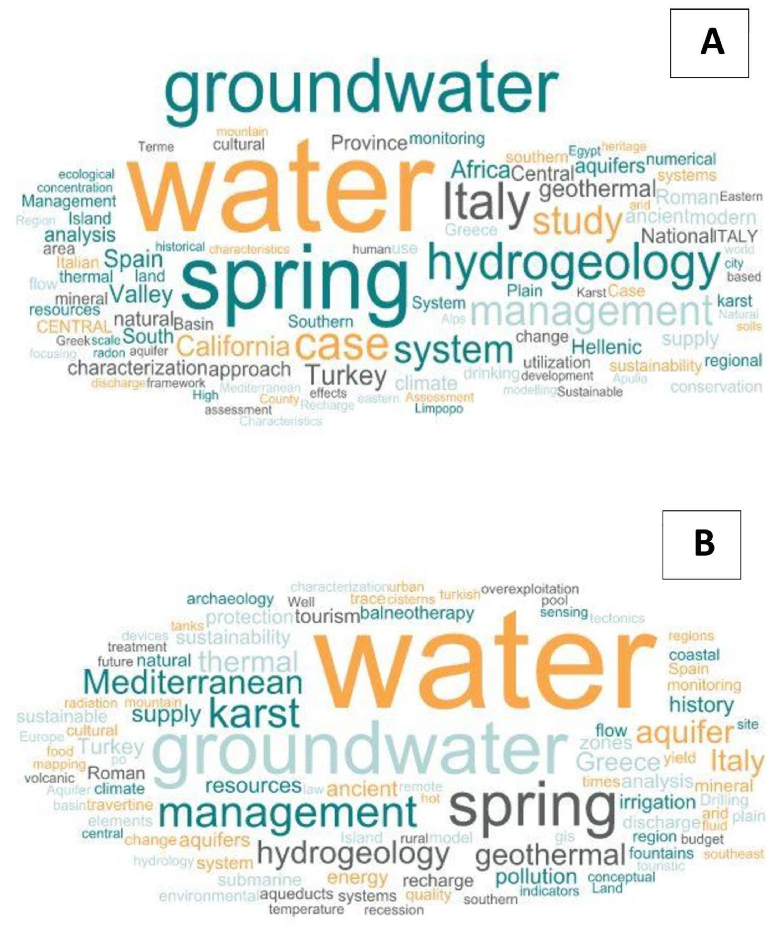
We examined the extent of literature on cultural aspects of springs in regions with Mediterranean climate. To do so we conducted a search of the Web of Science (WOS) bibliographic literature and then screened the resulting list of references, in order to select papers for analysis that we considered relevant to the topic. We then arranged the bibliography geographically and selected the key words listed in each paper. These keywords were filtered to remove duplicates (e.g., “spring water” versus “springs water”) and their frequency assessed. We used Pro Word Cloud app to illustrate the frequency of words appearing in the list of key words to show main usages, management, traditions, economic and legislative aspects, threats and issues around these fragile ecosystems.

3. Results

3.1. Background - mediterranean basin ecology and cultural overview

3.1.1. Mediterranean-climate Zone Vegetation and Habitat

Vegetation

Vegetation integrates aspects of climate, soil, time, and human use and impacts, and is therefore useful as a key characteristic of MCZs. Mediterranean vegetation has been too widely described and compared among most of the major Mediterranean climate regions for us to fully review that literature here. Instead, the reader is directed to Farandela et al. (2001, and the references therein). Nonetheless, individual and comparative studies clarify that Mediterranean vegetation transitions with distance from the coastline, from sclerophyllous shrublands to broadleafed or other forest types at distance from the coast. Sclerophylly is an adaptation to prevent moisture loss in periodically dry climates, and evergreen status likely reduces the burden of metabolic cost associated with seasonal leaf loss. In addition, waxy leaves may better protect coastal plant life from salt spray impacts. Such adaptations are critical for plant life to survive in low-elevation MCZ coastal habitats. While the pattern of structural and compositional shifts from coastlines to inland habitats in MCZs, less attention has been paid to the role of elevation in Mediterranean plant assemblages. This is in part because mapping is traditionally done in planview, while landscapes, such as mountains and canyons, are decidedly three dimensional (e.g., Stevens 2012). Temperature decreases with elevation through adiabatic atmospheric pressure reduction, while humidity and precipitation generally increase with elevation. Depending on the configuration of the coastal mountains, such topographic effects can exert sufficiently powerful influences as to shift ambient conditions out of the Mediterranean range, and into an entirely different climate regime. Also, we note that the prevalence of MCZs on western coastlines means that vegetation, particularly that at low elevations is exposed to afternoon sunlight, an aspect effect that exposes vegetation to the harshest thermal and solar radiation stress. This added stress may favor or evolutionarily promote reduction in leaf area, increased sclerophylly, and a succulent growth form, all characteristics common reported for low-elevation MCZ vegetation (e.g., Fox 1995).

Aquatic Freshwater Habitats

Perennial groundwater-fed springs and stream ecosystems in regions with Mediterranean climate are recognized as unique ecosystems, often having algal, macroinvertebrate, and fish species with strongly seasonal life history traits (Ball et al. 2012; Bêche et al. 2006; Bonada et al. 2007; Magalhães et al. 2007). Pascual et al. (above and 2020) described the biodiversity of 10 springs each in the karstic terrains of the Montsant Massif south of the Catalan pre-coastal ranges in the northeastern Iberian Peninsula, and in the Serra de Tramuntana Range on the island of Mallorca (Supplemental Information, SI). They reported 500 and 363 species, respectively of macroalgae, diatoms, bryophytes, cormophytes, aquatic invertebrates, and vertebrates from those springs. The springs there were regarded as outstanding biodiversity hotspots. Furthermore, their similarity analysis of the springs revealed only a low number of shared taxa, suggesting that each spring contains a unique, unreplicated biological assemblage that cumulatively greatly enhance regional biodiversity. Gasith and Resh (1999) described seasonal shifts in controlling variables among aquatic faunal assemblages, with physical factors such as flooding dominating assemblage structure and function during wet periods, and biotic factors like competition and predation becoming dominant during dry periods. The relative contributions of allochthonous versus autochthonous processes also may exhibit bimodal seasonal changes that differ from streams in non-Mediterranean climate regions. Power et al.’s (2013) studies of the Eel River in California corroborated those patterns, adding the characteristic of seasonal variability in productivity. Seasonal aridity can also reduce and disrupt habitat connectivity, and upland aridity can result in patterns of isolation that may increase the evolution of endemism in streams (Pires 1980; Power et al. 2012; Resh et al. 2013) and in springs (e.g., Fensham et al. 2023b). In contrast, Montezuma Well springs in the small MCZ strip mapped in central Arizona emerges from a 13,300 yr flow path with constant temperature and with naturally high concentrations of calcium carbonate and arsenic-rich water (Blinn 2008; Johnson et al. 2012).

Spring Riparian Habitats

Riparian plant assemblages surrounding springs and streams in Mediterranean climates violate the criteria proposed for Mediterranean vegetation. Profuse, non-sclerophyllous, broad-leafed, deciduous herbaceous, shrub, and tree growth can co-occur in such setting, and when occupied by farmers, many non-sclerophyllous agricultural plant species occur as well (Nabhan and de Granade 2013). Such habitats are often small, narrow, or otherwise limited in area and detectability on coarse-scale vegetation maps that are developed through remote sensing. Nonetheless, with permanent water availability, the vegetation in such settings often does not meet the restriction normally imposed by “dry-summer” climate conditions. Where occupied, intensively used, or created by humans, such springs and riparian zones are often described as “oases” (e.g., Fensham et al. 2023a). Human uses of such habitats has for thousands of years included manipulation and consumptive uses of water supplies for drinking, crop-based agriculture, livestock, fish hatcheries, and abstracted export to other regions, including urban areas.

3.2. Cultural Anthropology

3.2.1. History

Springs in many MCZs have been used by humans throughout late Neogene evolution and cultural history. Archeological evidence commonly reveals hunting camps at springs, as hunter and gatherer societies probably used springs not for dwelling, but as sites at which to ambush prey (and to be preyed upon). A deep history of human presence at springs was revealed by Cuthbert and Ashley’s (2014) paleo-reconstruction of Olduvai Gorge in Tanzania. They indicated that early hominin populations were closely related to springs, perhaps retreating to them during periods of drought. As cultures developed agricultural practices, settlement began to occur at larger perennial water sources, including large springs, rivers and lakes. Agricultural societies used those water supplies for irrigation, acquisition of aquatic food resources, and transportation. Subsequent towns, city-states, nations, empires, and dynasties have arisen in relation to technological advances in water supplies management, and disappear when those water supply management strategies fail (James 1966; Solomon 2011).
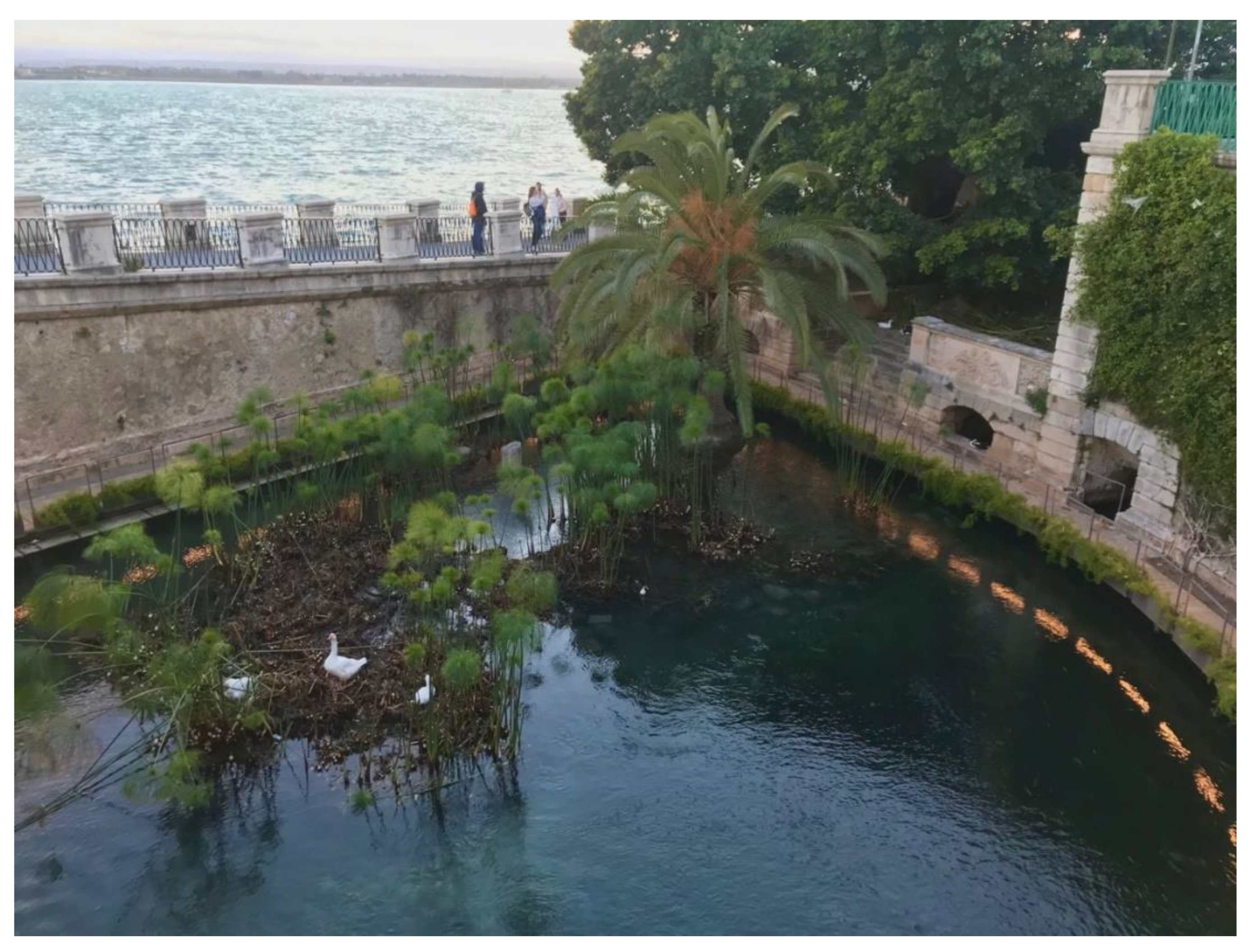
The first human settlements, and ancient to modern civilizations, were closely linked to freshwater supplies, which are essential for the establishment and existence of social organization, but also were important in the religious beliefs of ancient populations related to the magical and healing properties of water. The scientific literature is replete with examples of these strong connections to water: the ancient cities Corinth (Greece), Rhodes (Aegean Island), Priene (Turkey), and Syracuse (Sicily) were sites where the availability of high-quality karstic waters allowed development of high-density urban centers (Crouch, 1996; Solomon 2010). The ancient population of the Apuli, which in pre-Roman times inhabited the central-northern part of the Italian region of Puglia, and other populations were similarly supported by karstic water supplies in the Mediterranean Basin (Parise et al., 2023). Groundwater was a critical focus of life for the ancient Greeks. Establishment of an apoikiai (colony; e.g., Pithecusae) first required a sufficient supply of freshwater, and springs located in those landscapes represented both functional and symbolic connections and determinants of cultural identity (Frisone, 2012).
From the writings and archaeological studies of these cultures, we learn about ancient cultural relationships with springs and groundwater, as well as important lessons in water supplies management and technology. For example, the study of Roman hydraulic systems has provided fresh insight in water management in the face of globalization (De Feo et al., 2013). Contemporary indigenous cultures in arid regions on all inhabited continents throughout the world possess deep knowledge of the use of springs and most revere springs for health, spiritual, and recreative aspects. In Turkey, the importance of cultural association with springs is evident at fountains that are still today an important part of both aesthetic and functional integration of urban spaces and public life (Özer et al., 2010).
Historic literature confirms the cultural and socio-economic significance of springs and provides insight into ancient lifestyles and behaviors. Archeological evidence reveals the development of qanat since the Classical period of ancient Greece. Minoan hydrologists and engineers created long underground qanats (or aqueducts) to collect and direct groundwater to the surface to supply palaces and settlements with water in eastern Crete from 3200-1100 BCE (Angelakis et al., 2016). Qanat-aqueduct technology was employed to direct water from the Gihon Spring through the Siloam Tunnel into the city of Jerusalem in the early 7th century BCE. Similar conveyances were developed by the Persians in the middle of 1st Millennium BCE, a technology that subsequently spread towards the Arabian Peninsula and Egypt (Voudouris et al., 2013). Construction of the Hadrianic Aqueduct was completed in 140 BCE, providing spring water to Athen’s residents for the following millennium. Romans constructed advanced surface aqueducts from 312 BCE – ca. 300 CE to provide abundant freshwater to urban centers for potable and bathing uses. Subsequently, the Ottoman Empire reintroduced large aqueducts to supply their urban centers with spring water for religious and social needs (De Feo et al., 2013). For example, the city of Safranbolu, Turkey is famous for its abundant water resources and pool rooms, which serve as examples of the spatial use of water in traditional residential architecture (Ertürk et al., 2013). From the times of the Pharaohs to the Persian dynasties, and from Greek to Roman periods, the ancient literature is replete with examples of the use and regard springs held for these populations. The artesian springs of Egypt's Western Desert are primarily borehole sites drilled into the Nubian Sandstone aquifer (Powell et al., 2016). All of these examples of hydrogeological technologies and water management practices are relevant to understanding the cultural role of springs in both ancient and modern societies in Mediterranean climates.

3.2.2. Practical Uses and Threats

Among the most valued of waters, springs are often specially regarded as essential sources of clean drinking water. Innumerable farms, ranches, and settlements around the world have been founded on springs, and a quarter of the world’s population now relies on groundwater. A surprising number of large cities, including at least five European capitals, rely on springs for urban potable water supplies, and much of the river water used in other urban centers is derived from groundwater. For example, the Colorado River in the southwestern USA is 53% groundwater, and most of the river’s flow is abstracted from its channel to provide freshwater for MCZ southern California coastal cities, including Los Angeles and San Diego (Stevens et al. 2020). Many aquifers in Mediterranean seasonally-arid environments contain ancient groundwater and have low recharge capacity due to limited precipitation, high levels of evapotranspiration, slow infiltration rates, and poorly informed land use practices. This means that aquifers in some to many contemporary Mediterranean landscapes may not recharge in human timeframes and are therefore subject to increasing anthropogenic stress due to extraction, export, pollution, and antiquated supply systems. As a consequence, many and some large, historically important MCZ springs with long eco-sociological histories have been dewatered and many aquifers are threatened by overdraft.

3.2.3. Mediterranean Stereotypes

Attempts to define “The Mediterranean” as a personality, race, or cultural type have a long history. For example, Sergi (1901) compared facial features, written and spoken languages, and other early tools of cultural anthropology to investigate racial differences in European peoples. He concluded that post-Neanderthal neolithic humans had originated in Africa as an “Eurafrican species” and had radiated in Europe into African, Mediterranean, and Nordic races. He also concluded that the “Aryan race” was Asiatic and unrelated to Germanic and Scandinavian peoples. Genetic definition of European populations has since, at least weakly, distinguished “Mediterranean” from “African” and “Northern” European lineages since Sergi’s time (e.g., Athanasiadis et al. 2010), and efforts to stereotype a Mediterranean personality continues to misrepresent all of those groups; nonetheless, the Mediterranean cuisine continues to be revered (e.g., America’s Test Kitchen 2016).

3.2.4. Religion

The religious aspects of springs are highly culturally significant, including myths, symbolism, rituals, and buildings. Geva (2023) describes in detail the sacred architecture associated with reverence for water throughout human history. The Greeks widely celebrated the vital purificatory and therapeutic roles of natural springs through ritual practices in sacred sanctuaries with oracular functions. In these ceremonies, springs were venerated as direct connections to the chthonic realm (Stewart et al., 2017). Stymphalos, famed for Herakles' sixth labour (killing of the Stymphalian birds) and its association with Artemis, had a rich “geomythology” with a fountain-house to venerate the role of springs as the Greek city’s foundation and sustainability (Walsh et al., 2017). The Amphiareion near Oropos in Greece was an inflow clepsydra (water clock), likely constructed in the 4th century BCE. It is unusual in that time was measured there by the rate of filling of its large cistern from a sacred springs located just to the southeast (Leach et al. 2023; Theodossiou et al., 2010). The site was used for reception of divine information. After having thrown coins into the spring, believers were directed to a special sleeping gallery where they could receive divine guidance regarding therapy for their illness or solution to other problems. The Temple of Apollo and the prophetic powers of Pythia, the woman of the Delphic Oracle played pivotal roles in western geopolitics from the eighth century BCE to the fourth century CE. Delphi (delphys, "womb”) was regarded as the center of the earth (Gaia). The springs there emitted nitrous oxide and perhaps other aromatic hydrocarbons, causing the middle-aged female oracle to pass into trance and delirium, through which she issued her often puzzling pronouncements (Broad 2006; Etiope et al., 2006). Individual oracles were replaced by another usually middle-aged woman after having served a term of several years. It is difficult to over-estimate the wealth, power, and influence generated by Castalia Spring, as the aristocracy of the Mediterranean world at that time sought divine advice, bringing with them tribute and constructing statues in honor of Apollo and the site.
Overall, the role of springs in all cultures of the Mediterranean Basin has a long and important history. Ancient beliefs, traditions, water delivery technologies (e.g., the Roman and Ottoman aqueducts), and many other aesthetic and functional aspects of springs were clearly recognized, and were modified over time, with some still in contemporary use. In the following case studies, many of these connections become apparent.

3.3. Mediterranean basin case study 1: Springs of the Montsant Massif

3.3.1. Introduction

Relationships between culture and springs in a karstic range in the Mediterranean Basin were reconstructed from interviews with Monsant Massif elder residents in northeastern Spain. Informants particularly included farmers, hunters, and mushroom collectors in the Priorat region of Tarragona, northeastern Spain. This mountain range has a surface area of 160 km2 and is mostly comprised of calcareous conglomerates deposited during the Oligocene epoch, although Triassic limestones, dolomites, and sandstones of Muschelkalk facies as well as Carboniferous sandstones, slates, phyllite sediments are exposed in its southern region. Therefore, the massif contains several types of karstic aquifers that give rise to a great diversity of natural springs. The mesoscale climate is Mediterranean and continental, with average annual precipitation of 450 to 550 mm/yr. The region sustains a pronounced summertime drought when springs become the only water sources across extensive areas.
The population of the study area was divided into 13 small hamlets and villages with populations of 2 to 947 inhabitants, collectively including 3077 inhabitants in 2022. The population had reached a maximum of 12886 inhabitants in the 1887 census, and has since decreased by 76% in 135 yr. The Montsant Massif was declared a Natural Park in 2002, which stimulated new scientific studies and a focus on sustainable management of its natural heritage, including its springs.

3.3.2. Methods

In this comprehensive socio-cultural study of Montsant Massif springs, we considered it imperative to interview local residents who, due to their occupation or developed activities (professional or not) and advancing age, could provide in-depth knowledge of the landscape and its springs. The main criteria used to select informants were the following: - long life experience in their village (elders who had lived all or most of their lives in one or more Montsant villages); - their profession as farmers or shepherds or experience through the activities they practiced (e.g., hunters, mushroom pickers), conferring a deep knowledge of their municipal area; - a reliable memory; - communicative and willing to describe their experiences with springs; - other merits related to the knowledge of springs, such as having been involved in municipal water supply management tasks.
We interviewed informants from all of the region’s villages in the Montsant natural area except for Albarca, which at the time of this study had no inhabitants. Fortunately, we were able to obtain published interviews with 11 residents about Albarca springs from Palomar (2008). Interviews were conducted with a standardized format - although a relaxed atmosphere has been sought during the conversation. The questions posed to the informants were: - activities through which the informant became aware of springs; - list of the springs present in the different parts of the municipal district, indicating which were most important; - traditional and current uses of springs; - long-term discharge variation in those springs; - causes of the loss or disappearance of springs and potential for ecohydrological recovery; - public health value and attributed therapeutic properties; - legends, mythology, and folklore around the springs.

3.3.3. Results

Informants

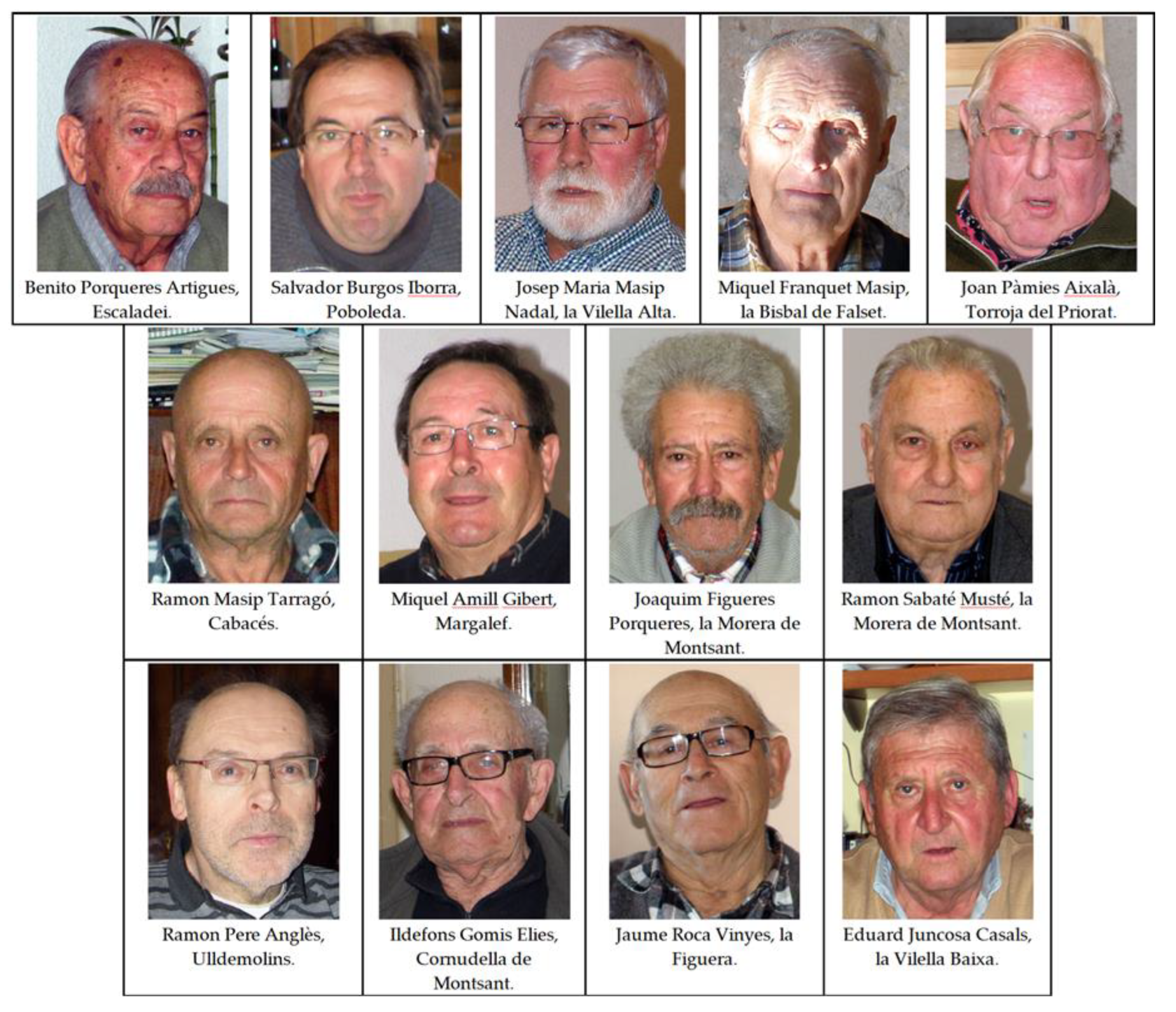
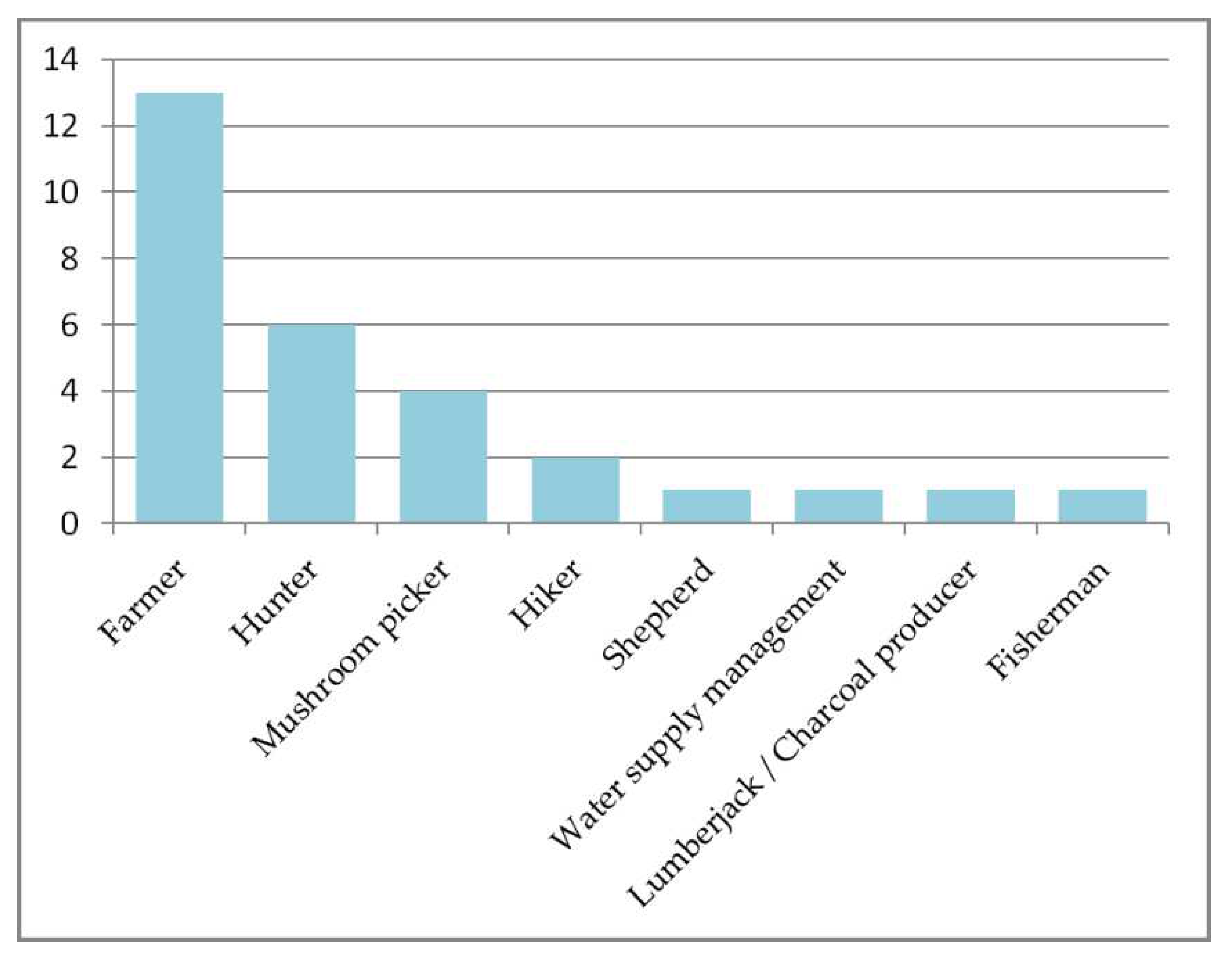
All informants were, or had been farmers, but most had practiced complementary activities that gave them a deeper knowledge of the territory, particularly hunting and collecting mushrooms (Table 1, Figure 2). All of them also were elderly: the average age of the informants at the time of the interview (February 2012) was 71.5 yr (range 52-90 yr). In the following, the villages to which the informants who mentioned it belong are indicated in parentheses. Bibliographic references are introduced when informant statements are not directly obtained from the oral memory of the interviewee.
Professions and Activities - The complementary or alternative professions practiced during some period of their lives included such activities as working as a shepherd, lumberjack, or charcoal producer. Nearly half of them conducted subsistence hunting, and nearly a third also had been mushroom pickers. In one case, the informant had temporarily been responsible for the municipal water supply (Figure 2 and Figure 3).

Springs in the Study Area

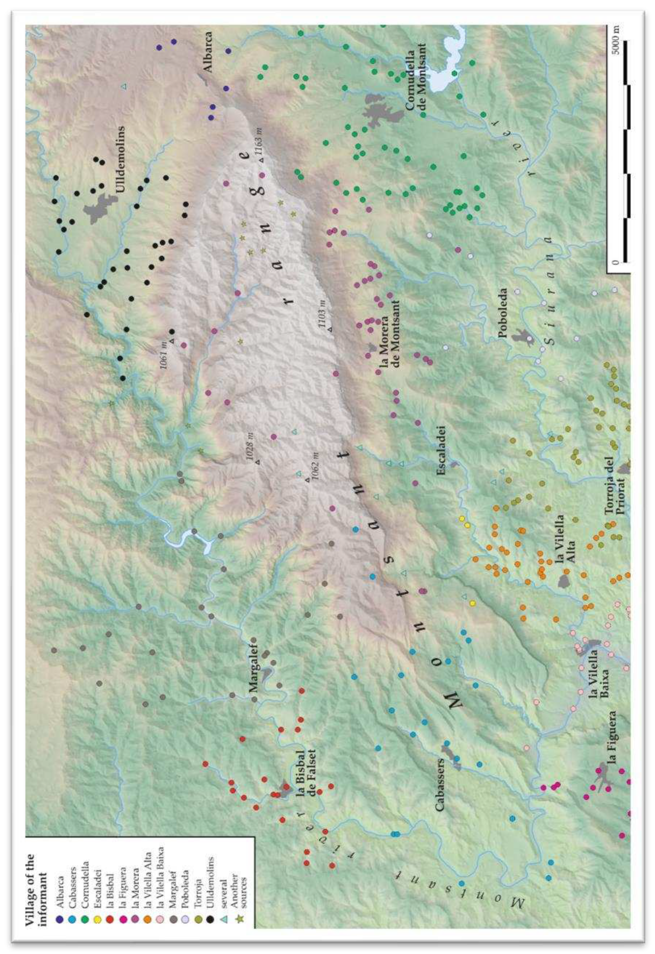
The number of springs identified by the informants was high (Table 1). Taking into account those cited by more than one informant, a total of at least 398 springs were recognized in the study area (Figure 4). Considering that the surface area of the region plus the neighbouring areas of the municipal districts is about 230 km2, the resulting density reported is 1.7 springs/km2. However, this knowledge of the region’s springs was likely partial because their knowledge and memory was not infallible. For example, up to 10 well-known springs from the hiking routes were not mentioned by any informant (e.g., Perea, 1984). Nonetheless, the informants reported springs abundance ranging between 13 (Escaladei) and 59 (Torroja del Priorat). Thoroughness also varied among the informant-derived list of springs. For example, in la Vilella Alta (area of 5.15 km2) the informant mentioned 37 springs (7.2 springs/km2), while in Cabassers, with a much larger territory (31.3 km2) and much richer precipitation, only 23 springs (0.7 springs/km2) were cited. In the latter case, the informant had listed only the most important well-known springs. Among the springs mentioned, the informants collectively generated a list of 55 they considered to be most important, based on discharge, intensity of use, and popular knowledge. The list of which springs were regarded as important varied among informants from different regions, from two in both la Morera de Montsant and la Bisbal de Falset, to 11 in Cornudella de Montsant.

Traditional and Current Uses

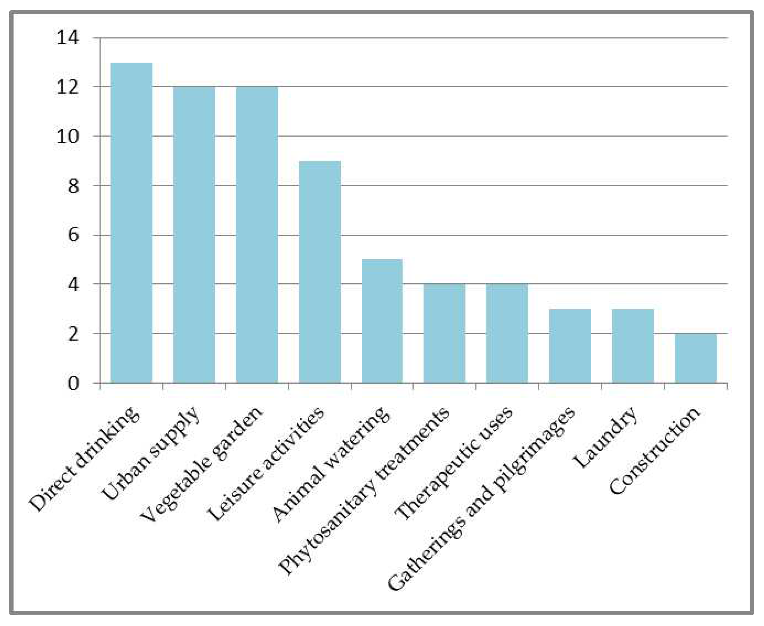
Overall, the most important uses of springs were for drinking water (both directly and through channelling to community supply networks) and for irrigation of subsistence vegetable gardens, which were mentioned by almost all informants. Recreational use, although secondary, was also widespread. Other less frequent uses, mentioned in fewer than half of the villages, were for animal watering, phytosanitary treatment, balneotherapy, gatherings and celebrations, pilgrimages, laundry, and use in small-scale construction (Figure 5).
All informants noted that farmers, hunters, mushroom pickers, charcoal producers, and carriers drank directly from springs. Most of the farmers drank water from the springs close to the plot they cultivated during their work time. In fact, many of the informants explained that most of the estates harboured springs. These usually had a meagre discharge, but were sufficient to allow the owners to drink, at least, most of the year. Considering that the size of the estates in this land of steep relief was generally modest, the surface density of springs was likely very high. In Torroja del Priorat, for example, the informant estimated that more than two-thirds of the estates had at least one spring. Typically the farmer brought spring water home in earthenware containers (Poboleda, Albarca), called gerrots, cànters o canterelles, depending on the size of the container. For example, Santa Llúcia Spring is located in a wide, shallow cave and supplied water to the Republican army field hospital during the Spanish Civil War (1936-1939), and lay in the rear of the Ebro front. A tank was constructed to capture the meagre, but constant flow. The practice of drinking water from spring sources has decreased now, in part because most farmers or hunters bring water from home (Poboleda, Cabassers). Despite this tendency, many still collect water from springs, especially in summer when urban tap water is of lower organoleptic quality (Margalef, la Figuera).
Community use remains a widespread practice. In fact, 11 of the 13 villages are still supplied, at least partially, with water from natural springs. Only la Vilella Baixa and Torroja del Priorat are not regularly provided with spring water, although they were in past times of drought. In some cases, the flow of several springs is channelled to the village, although some of them are only used when the others do not provide sufficient outflow (Poboleda). Other villages were only provided with water from a single spring, and periods of low flow in summer resulted in rationing: la Vilella Alta suffered from this situation until the 1960s. In addition to supplying the urban network, springs may be channelled to an urban artificial fountain (Poboleda, Cabassers). These springs can be recognized because they are signed: "Water without sanitary guarantee". The channelling and storage of water to guarantee its availability in the study area dates back many centuries ago (Escaladei). The Escaladei Charterhouse, founded at the end of the 12th century, was the first monastery of the Carthusian order in the Iberian Peninsula, and it very soon had a water supply channelled from the catchment of several springs in the valley. The same infrastructure currently supplies the village of Escaladei.
Most informants reported subsistence use of the springs for irrigation of vegetable gardens or even of small plots of fruit trees, especially when the orchards were near springs with perennial flow. "Spring(time) gardens" were in la Vilella Alta by temporary springs that dried up in summer drought. In other cases, small pools associated with ephemeral springs were used to store irrigation water through the summer (Escaladei). One of the informants reported that, among the people of the village, there was the opinion that vegetables irrigated with spring water tasted better than those irrigated with river water (Cabassers). The implementation of modern irrigation networks in some areas (e.g., in the valley of the Montsant River, with water from the Margalef reservoir) has reduced the importance of springs for irrigation of gardens and orchards, but traditional uses remain widespread in the study area.
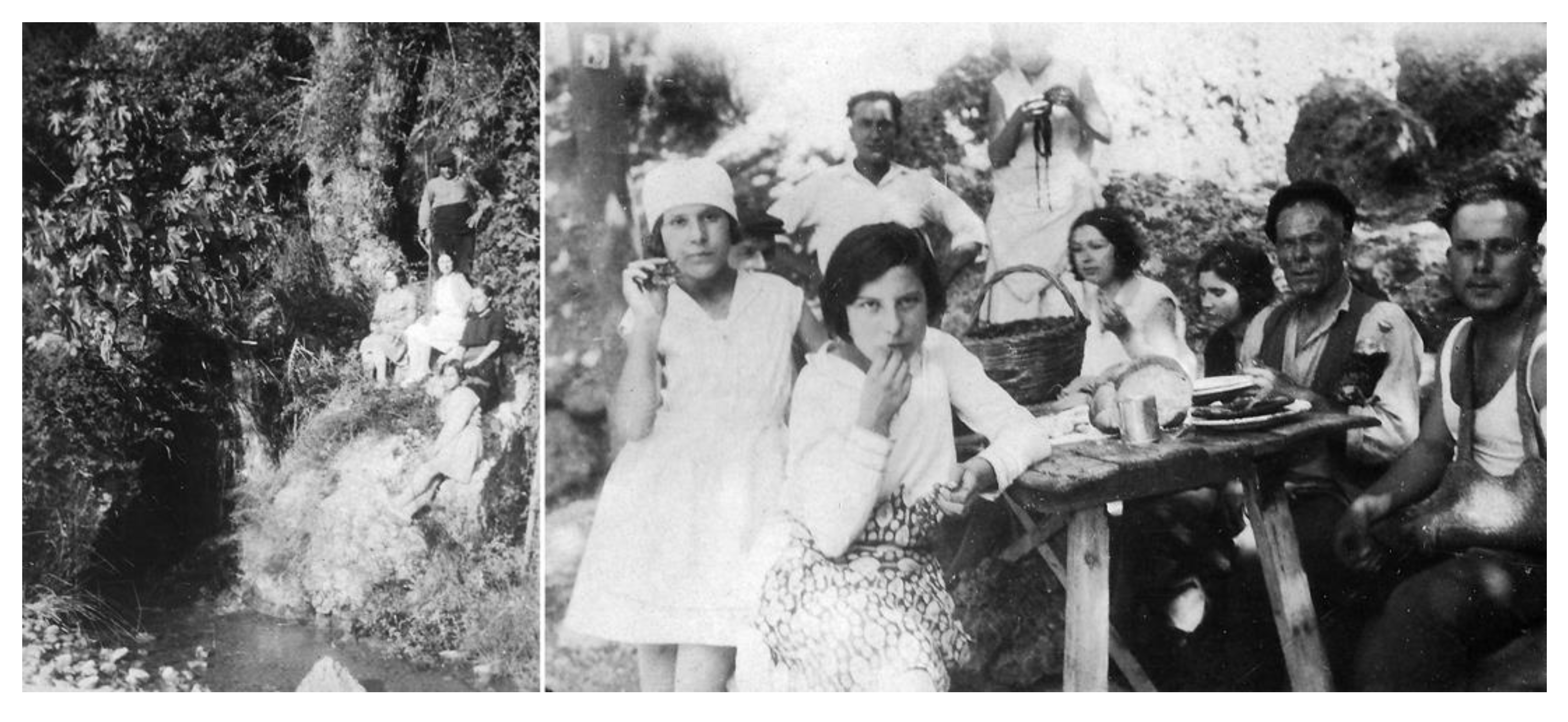
In 9 of the 13 villages, the informants report recreational or festive activities around some springs. It is not surprising that in semi-arid climate zones, springs are places for meeting and celebration (Figure 6). One of the most popular had been the tradition of going to a spring on Easter Monday to "eat the Mona" (la Bisbal de Falset, Cabassers, Margalef, la Morera de Montsant, Ulldemolins, Cornudella de Montsant, la Vilella Baixa, Torroja del Priorat), a popular outdoor lunch at certain springs involving a gathering numerous neighbours, and which ended with the traditional cake of this day, "la Mona" (Figure 6) (the Guenon). Although the event is less frequently celebrated today, some residents still do so. One informant also told of the celebration of Maundy Thursday around a spring (la Vilella Alta). It also was previously common for mothers to take their children for a snack at a nearby spring (Escaladei, Cabassers, Ulldemolins, la Vilella Baixa), but that practice too is in decline. On the other hand, springs continue to be the setting for recreational gatherings, lunches and other family or friend meetings (Poboleda, la Figuera, Torroja del Priorat). For instance, prior to the construction of the municipal swimming pool in the 1980s, the village youth went to bathe in the pond at Sant Blai Spring (la Morera de Montsant). Some springs also were places for free camping until designation of the Natural Park, (Escaladei). For example, there was a custom of a group of unmarried retirees - Los Campestres – to spend a week at a spring once a year (Cornudella de Montsant).

Animal Watering

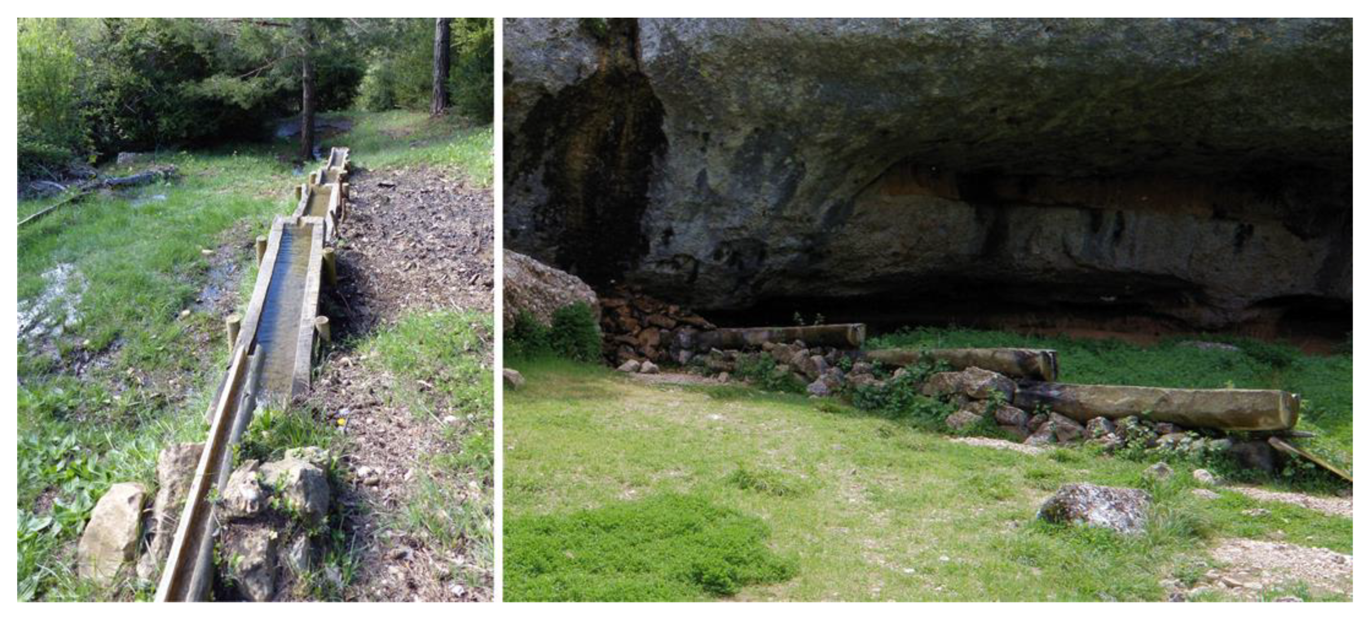
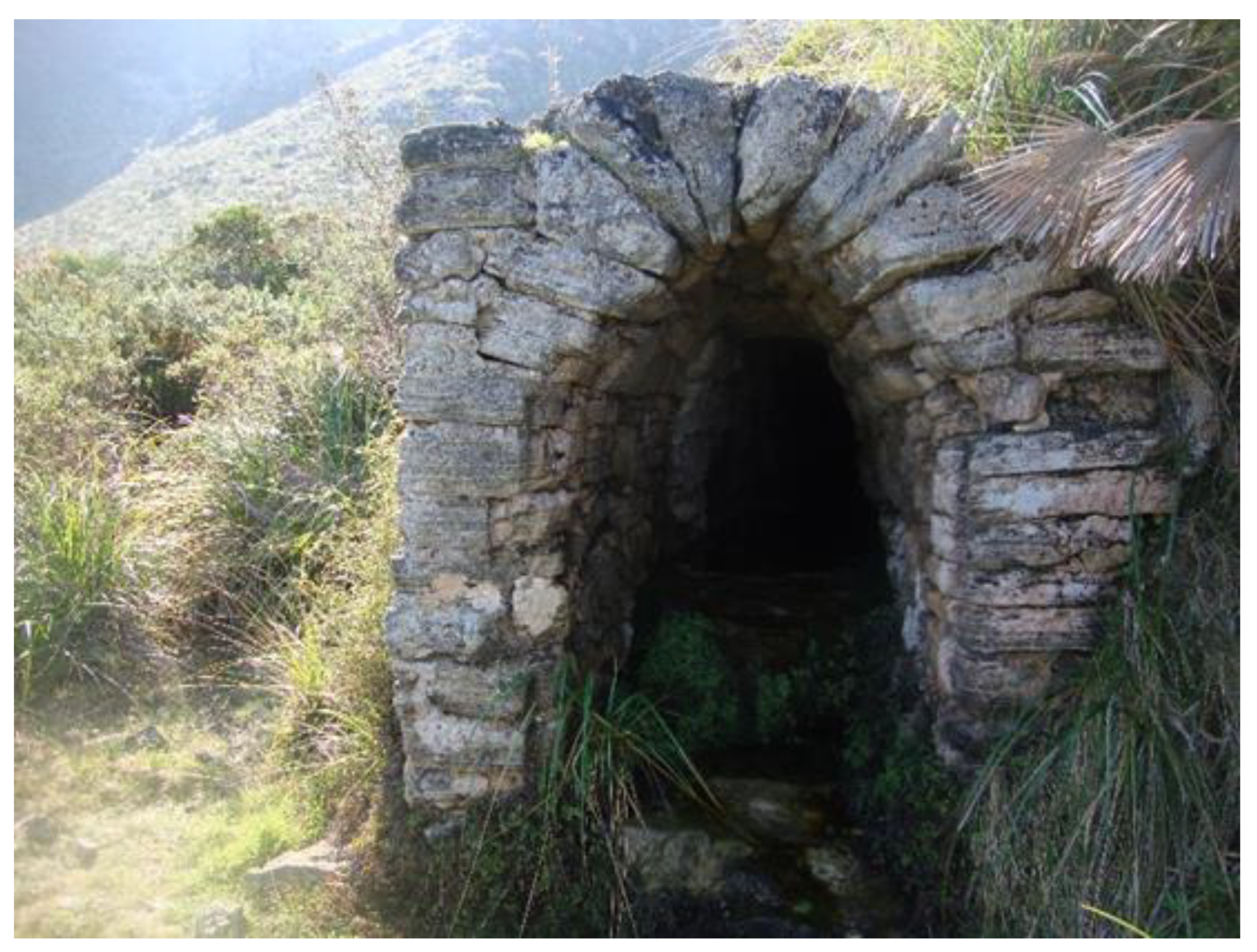
Livestock watering at springs was reported by the informants of five villages. Although pack animals, mainly mules and donkeys, formerly drank from troughs located at the entrances of the villages, some springs were also used for this purpose (la Bisbal de Falset, la Morera de Montsant, Cornudella de Montsant, la Figuera). In such instances, they were equipped with a small sink (Cabassers). Pack animals had disappeared completely in most villages by the end of the 20th century and, although some wineries have recovered them as a matter of prestige, this use has now ended. However, one informant reported that hunters are currently installing water troughs near a spring for wildlife watering (the Bisbal de Falset). In mountain areas, where livestock propagation lasted through the 20th century, springs were the only points with water available for flocks of mainly goats and sheep). These springs were often developed by installing bassis, troughs made up by a set of hollowed logs arranged in a line to facilitate watering of relatively large flocks. These structures have been reported at Martorella Spring (Cabassers), at Cova del Teix and Clot del Cirer springs (Margalef, la Morera de Montsant), and at Manyano Spring (la Morera de Montsant), and in many other springs of the massif (Figure 7). Currently, this use has disappeared along with the herds, but it has been possible to verify that the springs supplied with bassis are places still frequented by a great diversity of wildlife.
In villages located on the south face of Montsant where vineyards are widespread, the informants reported the use of water from the springs for phytosanitary treatments, mainly to make the so-called "caldo Bordelès" (Bordeaux mixture), a solution of copper sulfate and lime used to treat fungus, particularly in vinyards. However, long-term application of this fungicide results in soil contamination with copper, so its use has been banned in the EU.
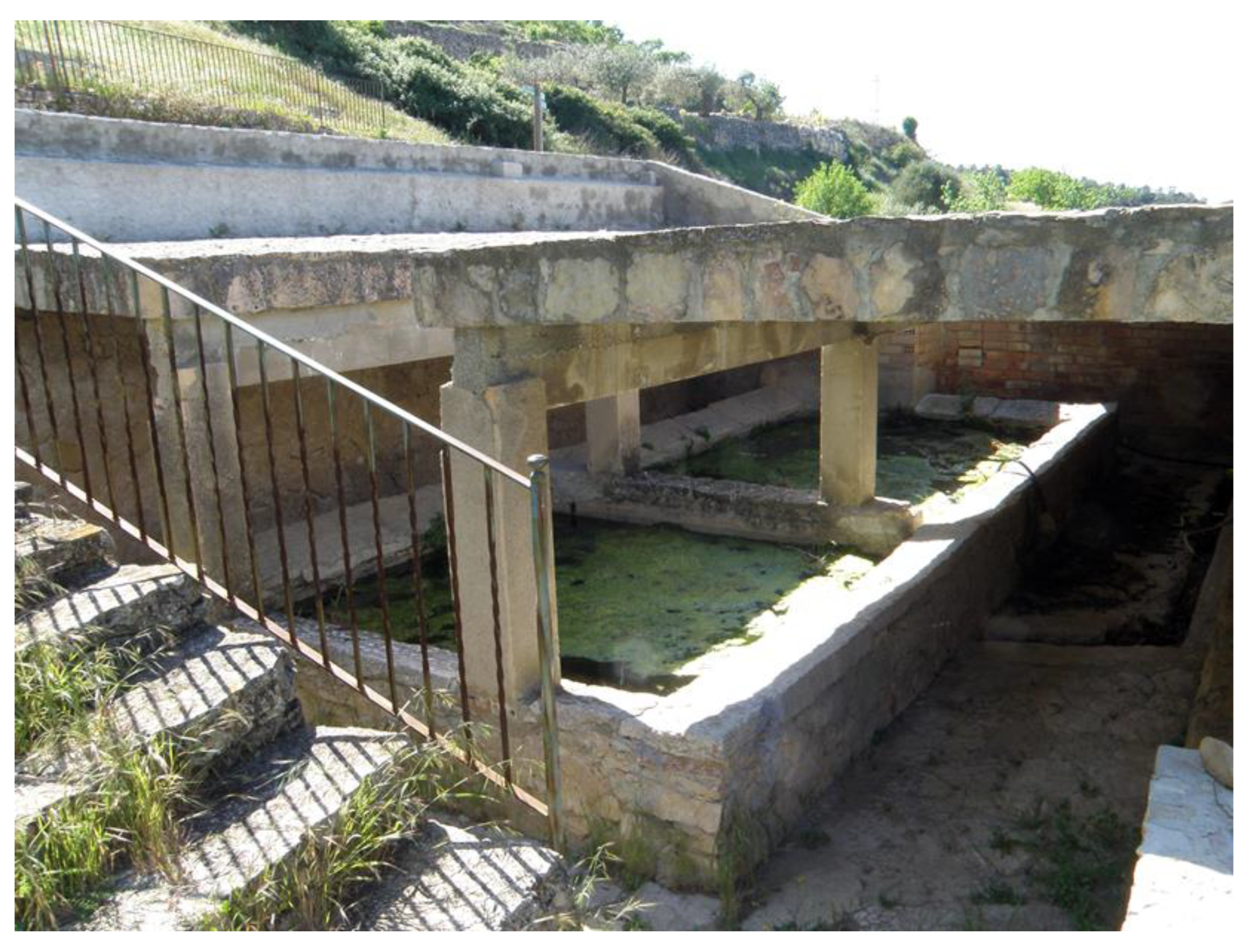
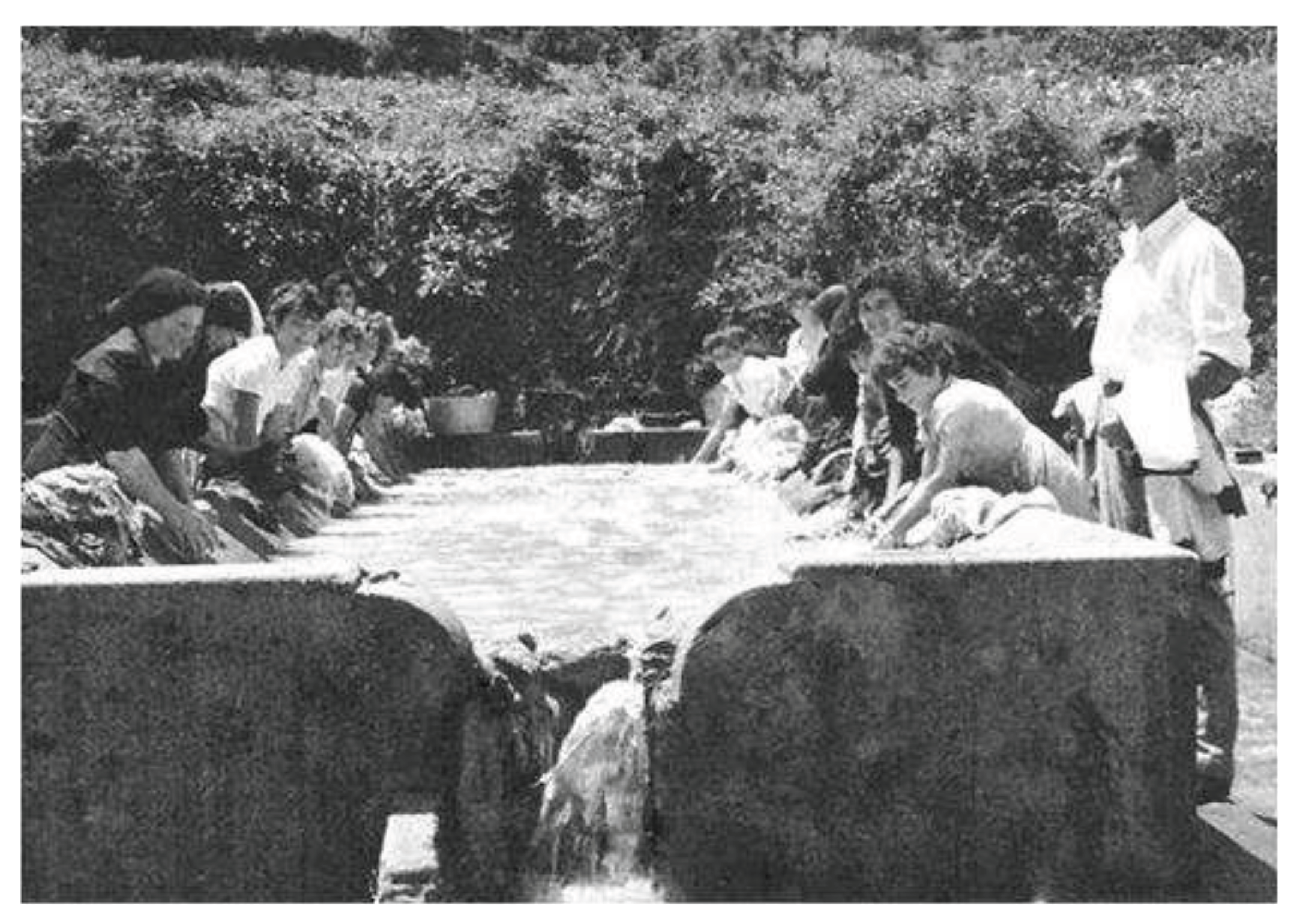
Although not a widespread practice in Montsant, some springs were used for washing laundry, which is an important social tradition. All villages in the rural areas had public wash places, where women went to wash their clothes, a routine but cumbersome task. In some cases, wash places consisted of a row of slabs at the edge of the river (la Vilella Baixa) for scrubbing clothes; however, in other villages a specific enclosure with a scrubbing deck was constructed to support wash basins. In some cases, these wash places were located next to the springs from which they obtained water. The informants reported wash basins were connected to Sant Miquel and de Baix springs, the latter restored at the end of the 20th century (Cabassers), and in Font Vella Spring, also recently restored (La Figuera, Figure 8). Palomar (2008) collected the references of the informants regarding Poble Spring (Albarca), where the wash basin was a natural depression in the rock with slate slabs installed for scrubbing clothes. When this spring dried up, laundry washing had to be performed at Teix Spring, 20 minutes from the village. The wash areas were, of course, places of socialization, where in addition to washing, women talked with their neighbours, recited folk tales, and sang ballads (Palomar, 2008).

Celebrations

Montsant is a land of hermitages, where gatherings, celebrations and pilgrimages are held on designated dates (Table 2). Some of these hermitages are located next to natural springs, which become a main element of the celebration (Cabassers, la Bisbal de Falset, Margalef).
Other occasional uses of springs mentioned by informants were related to construction and forest fire facilities. Spring water has been used to make mortar for covering the walls of the typical small stone shacks, huts and shelters of La Vilella Baixa, and for house repairs in Albarca (Palomar, 2008). In addition, some springs were diverted to supply pools throughout the area used to extinguish wildfires (la Morera de Montsant).

Long-term Discharge Variability

An issue of great interest, both locally and globally, is trend assessment in discharge over long time periods, in this case over the course of the informant’s lives. Most informants declared themselves unable to answer this question and, among those who did, there were contrasting opinions: some believed that, as a whole, spring discharge had decreased (La Morera de Montsant, la Vilella Baixa), but other informants did not see appreciable changes (Ulldemolins, la Figuera, Torroja del Priorat). In an odd case, decreased discharge of a spring was attributed landscaping an adjacent mass grave site dating to the Spanish Civil War with cypress and European nettle tree (Escaladei). In other cases, decreased discharge was attributed to the lack of maintenance (Cabassers, Margalef, la Morera de Montsant). Most springs in the study area have been forced to outflow by drilling into the terrain until reaching the water-bearing vein. Such systems tend to collapse over time due to sediment clogging, and therefore have to be periodically cleared.

Rehabilitation of Lost Springs

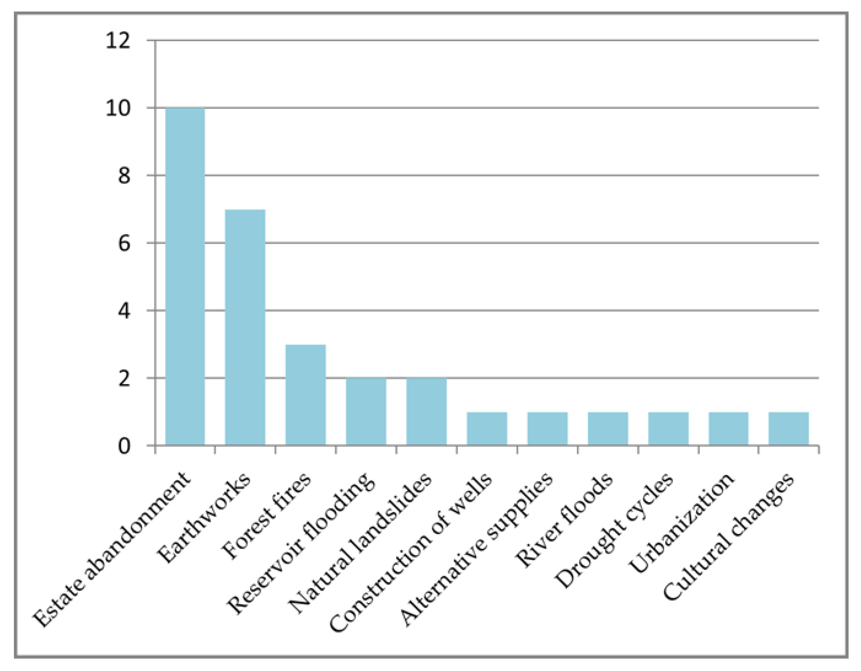
Does it make sense to recover or rehabilitate lost springs? The continued loss of springs was reported by all informants. All had heard of springs they never saw and knew of springs that are currently missing or engulfed by vegetation, and are therefore inaccessible. On the other hand, although it is known that springs can collapse in relatively short periods if not regularly cleared, sometimes the outflow is suddenly choked. Such occurrences were attributed to various causes (Figure 9).
Most of the informants mentioned the abandonment of crop agriculture, a progressive trend throughout the 20th century, which is on-going today, continues to be the main cause of the spring loss (Poboleda, la Bisbal de Falset, Cabassers, Escaladei, Margalef, la Morera de Montsant, Ulldemolins, la Figuera, la Vilella Baixa, Torroja del Priorat). As highlighted above, many small springs were associated with crop plots and were used almost exclusively by the owners. This type of springs is doomed to disappear in a few years once the crop is abandoned due to lack of livestock grazing and overgrowth by vegetation.
Another cause to which many informants attribute the loss of some springs are the earthworks carried out either to condition the land with terraces and thus facilitate cultivation (Escaladei, la Bisbal de Falset, Cabassers, Torroja del Priorat), or for the construction of roads (la Bisbal de Falset, la Vilella Baixa) or forest paths (la Morera de Montsant, Ulldemolins), which sometimes involve the drying of springs in the nearby area. Many of the informants associate these works with the reconfiguration of the channels through which the underground water circulates, as an explanation of this phenomenon.
A similar argument is made regarding the drying of certain springs as a result of forest fires (Escaladei, la Vilella Alta, Figuera). In this case, the informants believe that the channels left by the roots of burned trees which end up rotten, lead to changes in the circulation of underground water, which would explain the choke of the outflow.
The loss of springs that are submerged under the water table of the reservoirs is not a hypothesis but an indisputable fact and this is what two of the informants reported. For example, the Ton del Caime spring (Margalef) or the Sant Martí spring (Cornudella de Montsant), which became permanently flooded by the Margalef and Siurana reservoirs, respectively.
Natural landslides have also been causally associated with the sudden drying of springs. It would be the case of the Sellonga del Joan Ardèvol spring (la Vilella Alta) or the Canaletes spring (the Morera de Montsant). The explanation would be similar to that of earthworks.
The rest of the potential causes have been indicated by only one informant. The construction and exploitation of wells is one of them: the exploitation of the aquifer would lead to the drying of some springs that are fed by it (Cornudella de Montsant). The development of alternative water supplies, such as modern irrigation networks, has also favored the abandonment and loss of some springs (the Bisbal de Falset). It would also be a cause of spring loss the cultural changes encouraged by the replacement of pack animals by motor-driven vehicles since, if some time ago it was the custom of many farmers to have the lunch at the plot, particularly when it was far away from the village, today this has been almost completely lost and, with it, the need to have a supply of fresh water (Torroja del Priorat). The informant from Vilella Baixa provides two additional empirically proven causes: river flooding and urbanization. The strong flood following the heavy rainfall of October 1994 would have caused the disappearance of two springs that drained near the Montsant riverbed: the Font Bona spring (at that time the best known and most visited in the village) and the Segalar spring. On the other hand, when the village streets were paved, two springs located in the urban area - Hostal Spring and Molí Spring - were connected to the sewer, which had been installed at the same time. Paradoxically, two urban fountains fed by the drinking water network were built in both places. Finally, it has also been argued that, indirectly, the periodic cycles of severe drought might imply the disappearance of springs, since often, when the known springs dry up, people try to find new veins in the vicinity. In the case that this search succeeds, the original springs end up being lost (Ulldemolins).
Some lost or abandoned springs have been recovered in recent times with varying success. In some cases, recovery or restoring has carried out by the city council because nearby springs well known to the residents are concerned (Poboleda), or because they are located close to roads and, therefore, suitable for a higher number of people (la Morera de Montsant). In others, the initiative arises from the management unit of the Natural Park, which has recovered several mountain springs: in some of these the traditional wooden troughs damaged by the passage of time have been replaced by new ones (la Morera de Montsant).
Among the informants there is the general thought that it does not make sense to recover abandoned or lost springs if there is no clear use planned for them (Cabassers, Margalef, Ulldemolins, la Figuera, la Vilella Baixa) or if they do not include dry stone constructions –or other material elements- which could be considered heritage elements (Torroja del Priorat). Accordingly, it could make sense to recover some springs close to the villages (Poboleda, la Bisbal de Falset, la Vilella Baixa), or linked to hiking or other types of outdoor activities (Poboleda, Margalef, Ulldemolins).

Health and Balneotherapy

The key informants were asked about the relationship of the springs with relevant episodes related to public health, as well as about the therapeutic properties of their water. None of the informants remembered any incident of poisoning or epidemic due to the consumption of water from the springs. However, related to this issue, one of the informants had heard about a typhus epidemic that caused the death of 18 people aged between 16 and 30 in the village, at the beginning of the 20th century. Some neighbours attributed the incident to a low flow mine that circulated under the houses of the village that might had been contaminated with faecal leachates, although this fear could never be confirmed (Torroja del Priorat).
On the other hand, some informants did report beliefs, more or less founded, about the healing properties of the water from the springs. One of the springs had been used in a case of a child patient with tuberculous spondylodiscitis, known as Pott’s disease (Escaladei). In Ulldemolins, the water from the Mina spring was consumed for diuretic purposes due to its low salt content. In la Vilella Baixa, the water from a ferruginous spring was given to people with whooping cough (pertussis). In Albarca, it is told of children with whooping cough were submitted to drink water from nine different springs (Palomar, 2008).

Legends, Mythology and Folklore

The Font Vella spring (also known as Silvestre Spring), near Ulldemolins, holds the oldest reference in the village and most likely in the whole scope area, since its existence is dated to 1286 (Pere and Amigó, 1997). A legend tells that the image of Virgin Loreto was found there, an event that motivated the construction of the Loreto hermitage at the entrance to the village coming from this spring.
In the case of the Font Nova de Cornudella de Montsant, a belief existed that the spring water came from the Pyrenees more than 100 km away to the north, since its flow increased after periods of elevated temperatures, a fact that was related to the accelerated melting of the snow.
As in many other aspects of the rural world, there is a documented belief in the influence of the lunar cycle, in the sense that if the springs were cleared with Waning Crescent Moon, the flow increased, while if it was done with New Moon there was a risk of decreasing the discharge and even drying (Palomar, 2008).
A beautiful legend explains the appearance of the five most abundant springs in the area of Albarca, all of them located the nearby hamlet of Mas d’en Lluc. According to this oral tradition, a hermit living on top of Montsant a long time ago, announced to the people dwelling in Albarca the birth of Jesus Christ but soon after, he disappeared. About 30 yr later he returned to the village and converted its neighbours to Christianity. Shortly afterwards, for three consecutive nights, a huge image of Jesus crucified made of moonlight appeared in front of the village: its hands reached the top of the cliff of La Gritella and its feet touched the ravine of Argentera. From the wounds on the hands and feet, as well as from the gash on the side, rays of light came out. The hermit explained to the neighbours the passion and death of Jesus Christ, which he had known through revelation. Once Christ was resurrected, the rays of light from the wounds became the springs of Grau, Puntal, Freda, Mas de l'Oliver and Canals. In this way God provided the inhabitants of Albarca with abundant water, a land characterized by the scarcity of this resource, in recognition of their conversion (Palomar, 2008).
In addition to these beliefs and legends most of the local folklore linked to the springs came from the laundry activity. Wash places became the main points of female socialization as it has been introduced in section 3.3.3. Several tales and ballads were recited or sung in these places. The folk tale El festeig a la font (The courtship at the spring) tells a story of a spring as the place where boys seduce girls. The ballads of Caterina d’Alió and Les tres ninetes (The three little dolls) come to the same topic (Palomar, 2008).

Other Aspects of Interest

Another interesting topic is the taste of springs water. As in many other places, the informants speak about some springs with strong-tasting water and others with water qualified as molla (feeble or weak; i.e., tasteless), such as Poboleda, Cabassers, la Morera de Montsant, Cornudella de Montsant, la Figuera, la Vilella Baixa, Torroja del Priorat, and Albarca. While the former are considered good for drinking, the latter, if not strictly necessary, are dedicated to other uses (particularly irrigation); in past times there was actually a selection of springs suitable for collecting drinking water. Even a case in which the owners of a spring with tasteless water occasionally added an amount of lime to the next storage basin to increase the strength of its taste, has been told (la Vilella Alta). This demonstrates that the water taste was already related to the salt content. In relation to the taste, some informants have emphasized the iron flavor of the water from some specific springs (Vilella Alta, Vilella Baixa, Torroja del Priorat) or the fact that it leaves a thin coating of iron oxide on the surfaces it soaks (Cornudella de Montsant).
On a different historical note, some people who had inhabited Albarca remembered a curious custom acquired through oral transmission but was well-documented. Towards the end of the rule of the Escaladei Charterhouse over most of the lands of Montsant, the farmers who has exploited the Carthusian properties were obliged to pay a unique, symbolic tax. The taxation required each of them to bring to the Carthusian prior, once a year, a bottle of water from a spring located around the terrain they cultivated. In exchange, the farmers were invited to eat a meal at the Charterhouse (Palomar, 2008). Of course, this was an unequal trade-off, but it exemplifies the enormous symbolic importance related to springs, and the importance of their roles in culture.

3.3.4. Discussion and Conclusions

This case study provides an in-depth example of the close relationship between rural societies and the spring ecosystem in Mediterranean lands. Due to the age of the informants, it is necessary to place most of the statements, explanations, and memories in the first half of the 20th century and this fact is worth considering. In fact, these are the last generations that have lived in a world in which there was a huge gap between the urban, industrialized, and modern world and the rural, traditional, close to the nature world. Throughout the last century, these differences have faded until become very small in the current society of technology and relational networks. The study area is a Mediterranean mountainous area, in the hinterland of the coastal plain towns, which did not receive the influence of modernization until the 1970s. Therefore, the memory of the 13 people interviewed (plus that of the 11 witnesses collected in Palomar, 2008) constitutes a document of immense value given that this generation is disappearing.
The informants tell us of a time when the springs were much more abundant and had a much greater importance than at present. Springs, in fact, pervaded most of the vital aspects of that society. Certainly, water has always been an essential element for the establishment of life, and, in the Mediterranean context, it is scarce during the summer season when it is most needed. In the study area, many river reaches dry up during summer and the rest dramatically decrease the flow, so that the springs become, for most of the population, the only water source for drinking, for eating (enabling both the irrigation of self-consumption vegetable gardens and watering livestock), for fuelling their “machines” (watering pack animals), for laundry, and for personal hygiene. It is not surprising, therefore, that springs were also the subject of festive events and celebrations.
The implementation of urban supply systems and the construction of reservoirs and irrigation networks from the second half of the 20th century, combined with a decline in agriculture and the progressive abandonment of many cultivated areas is precipitating the disappearance of a major portion of the spring ecosystem. Present-day interest in springs is limited to use by hikers and other practitioners of outdoors activities, to citizens concerned with cultural preservation, and small academic circles that appreciate them as biodiversity hotspots.
This evidence invites serious reflection. Springs have been, in the Mediterranean area, essential elements for settlement. The necessity of permanent water fuelled the search for shallow veins and methods to concentrate groundwater emergence and flow. In this way man, without being aware of it, while multiplying a network of water points for the development of society, was also generating a meta-ecosystem which includes remarkable biological richness and diversity (Pascual et al., 2020). Paradoxically, with the regression of cultivated land and renaturalization of the environment, the superficial expression of the water from the springs is being lost and, with it, knowledge, traditions, and biodiversity. Urgent and determined action is therefore needed to preserve what has come to us: the remains of a treasure that perfectly represents the synergy of natural and cultural heritage, an ecosystem where the line that separates both becomes blurred and where the concepts of artificiality and naturalness become liquid.

3.4. Mediterranean Basin Case Study 2: Mallorca Island Springs

3.4.1. Overview

In this case study we describe and discuss the Spanish Mallorca Island springs database (MIS db; www.fontsdetramuntana.com) created by Andreu Morell and Mario Fontán. This database is the result of their intensive cultural inventory of about 1700 Mallorcan springs. Although not its initial objective, this project became a thorough inventory of the springs of the island. The website was created by Andreu Morell at the beginning of 2011. By the end of that year, the team was already completed with Mario Fontán and Pedro Fidel Castro. All of them had been interested in the springs of Mallorca for many years before meeting each other. All contributed detailed firsthand knowledge of the springs in the Tramuntana Mountain Range (Morell and Fontán), and PF Castro developed an initiation database with more than 1200 georeferenced springs recorded across the island. Each spring visited was documented with a sketch that includes the associated vernacular stone structures that protect most of them. The web also includes nice explanations about the types and functions of these structures.
The conceptual scope of the project involved defining a spring as a place where, naturally or through an excavation, underground water flows towards the surface only by gravity, without the aid of any other energy source. Additionally, this condition had to be accompanied by the intention to make some specific use of the water (Figure 10). Over a span of 11 yr (2011-2021), information on more than 1500 springs located throughout the island was added to the website. The website was very well received from the beginning, and research was favored over the years by many other collaborators.

3.4.2. Methods

The research methods were described in detail in Castro (2013), in which the many sources of data were emphasized. They included the general local literature, a specialized bibliography on hiking, hydrology, popular architecture, modern and older cartography, aerial photography, consultation of historical archives and, of particular importance, oral information. Concerning the latter, Castro (2011) noted that only approximately half of the springs in two different study zones appeared on any known map, and 18% of all the located springs had never been previously cited on any known text or map.
Field work was focused on the description of the structures and uses of the water. It was carried out with the specific objective of looking for springs, from which some data on the approximate location may have been previously noted. The equipment used was very basic, including one or several cameras, a notebook, and tools to measure the structures. Measurements taken in the field were sketched in a notebook, which could be augmented with notes and observations from the owners, when possible. Georeferencing was accomplished using a GPS device. The coordinates recorded for a spring, whether an underground structure (mine, qanat) always referred to the point where water reached the surface.
Field notes were translated to digital files and later uploaded to the internet. The information published on the web consists of: the location, including the coordinates and name(s) of the place where the spring is located; the type of property; the main use; and the typology of the main structures. This is followed by a description of the most important subjects related to the spring. Importance was always given to the name of the spring (toponymy) and an effort was made to identify each one by the name by which it had been known historically, considering the historical significance of the possible meaning of the place name. In the absence of a known toponym, the source was usually named as the place where it was located, always indicating that it is a toponym created so as not to leave the spring unnamed. Field descriptions were always accompanied by relevant photographs and a diagram of the spring. Spring diagrams may include front, side and plan scale representations of the associated structures and their surroundings.

3.4.3. Results

Mapping

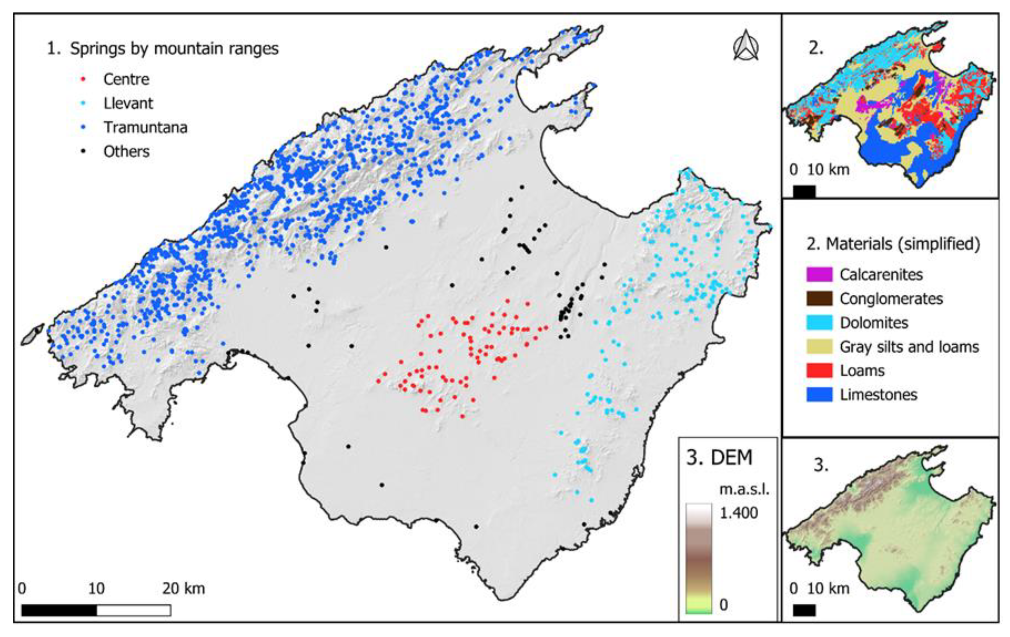
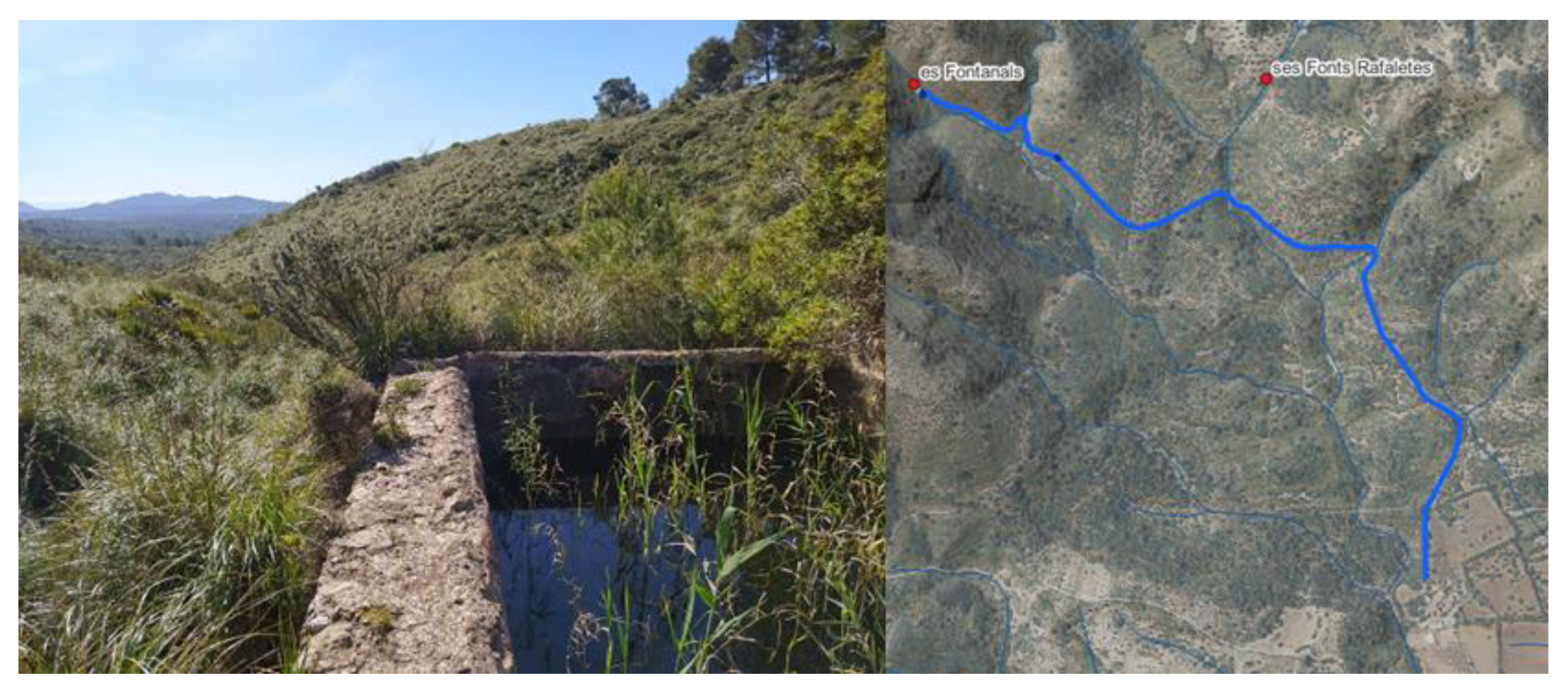
There are currently 1671 Mallorcan springs published in the database, of which approximately 1400 are located in the Tramuntana Mountain range that runs along the north-west coast of the island (Figure 11). Some of the database registries do not refer to a spring as it has been defined in Materials and Methods section, as there are some registries related to wells for which there is no certainty that had ever been truly springs. The estimated number of small springs still to be visited, described, and registered ranges from a few dozen to a hundred. In addition, there are several springs for which access has not yet been allowed. Therefore, it can be stated that about 95% of all springs in Mallorca have been registered in the database. However, additional springs may continue to be discovered, including some with an extensive hydraulic system. The last major finding, not published on the web, was in April 2023: es Fontanals is a small spring with a channel >2200 m long that traditionally covered an oil press in the mountains of Artà, east of Mallorca (Figure 12).

Distribution

The distribution of the springs in Mallorca is clearly not homogeneous (Figure 11). Most of the springs are located along the Tramuntana Mountain Range, but there are two other groupings located in central Mallorca (81 springs) and the Llevant Mountain Range (212 springs). In the Tramuntana Range dolomites predominate. This lithology favors the infiltration of rainwater, which finds its way to the surface where the dolomites meet impermeable materials, predominantly clays and loams.
The Tramuntana Range has a surface of about 1050 km2, with a resulting density of 1.33 springs/km2. However, as stated above, the distribution of these montane springs is not homogenous. Although the range reaches 1445 m a.m.s.l at Puig Major, 82.5% of the springs are located below 500 m elevation and only 6 occur above 1000 m elevation.

Typologies

Classification of Mallorcan springs was done by categorizing the manmade structures that allowed groundwater to flow towards the surface enabling its use. This classification led to identification of four groups of springs: dripping springs, springs, qanats, and spring-flow tunnels (Figure 13). The main categories into which the studied sources are divided, from least to most complex, are the following:
  • Degotís (dripping spring). Inside some caves and at the base of cliffs, in the places furthest from other water sources, there are some dripping springs that usually consist of ceramic cups or jugs, or small dug basins in which the water that falls from the roof is collected. In some of these there was no permanent structure, and the cups or jugs were carried by the people who wanted the water; some of these were on cliffs near the sea, where the men could leave the jug to fill while they were fishing (Example G in Fig. CS 1.2.4).
  • Fonts or brolls (raw springs). Usually the brolls (D) are the simplest springs that flow from the ground, with little modification beyond perhaps excavation of a pool. Fonts, described below have a greater degree of development of dry-stone structures surrounding them (A). The degree of development structures is not related to the extent or quality of water management structures. Also, the exact point at which a spring becomes a mine is not easily determined, as they can sometimes be covered with shallow drystone structures (B).
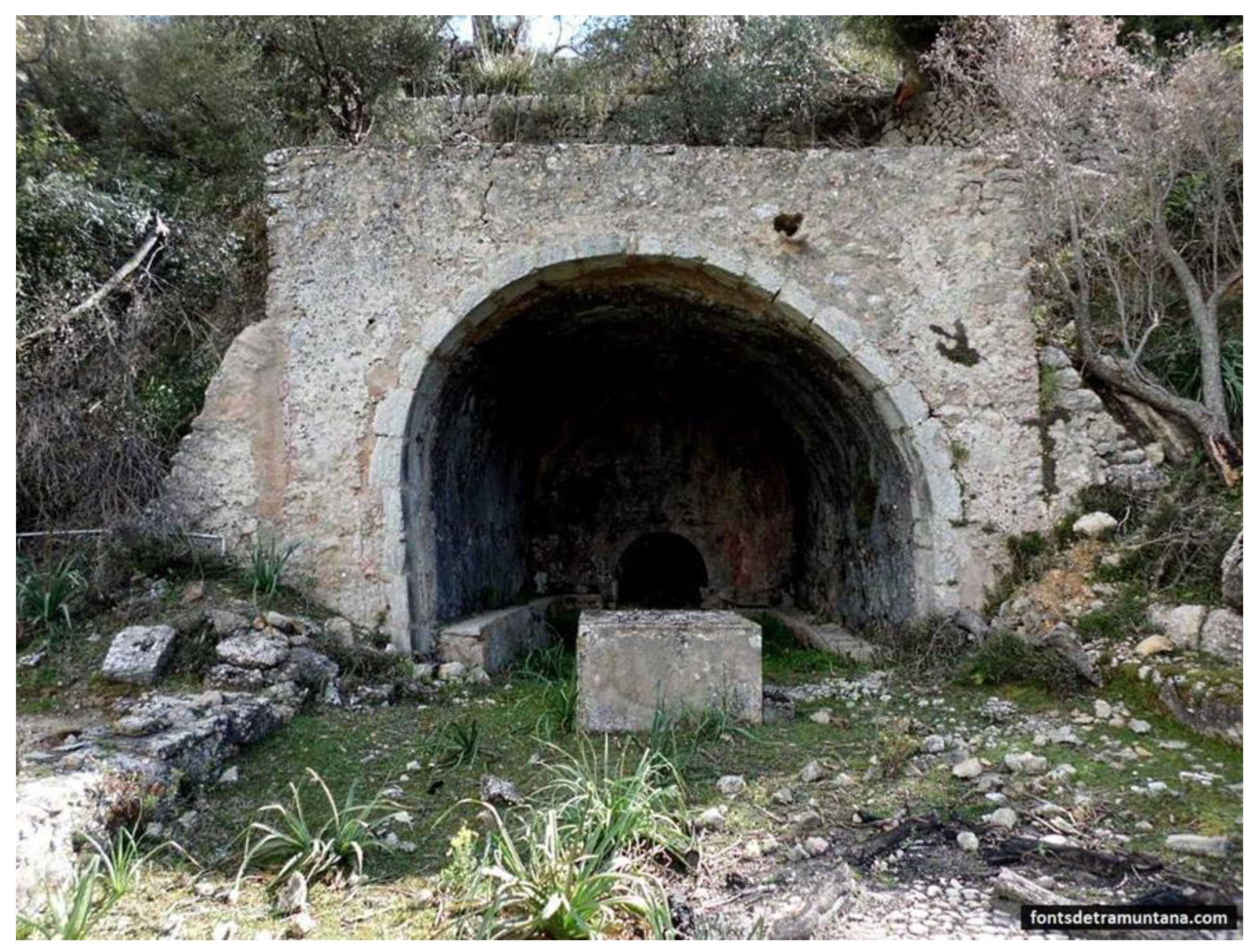
  • Fonts de mina (spring-flow tunnels). These are tunnels without any vertical shaft leading to the surface. Mines may not have internal structure (C) but may have small ponds at the beginning (B) or wells of depth. Some mines lying slightly below the water table also have been used as cisterns (H). Also, the mines that have been dug only in their initial point can transform into a well accessible by an underground staircase (I).
  • Qanats. The qanats exist with the same variations seen in the font de mina category, but always have at least one vertical shaft (E, F, J). Also, there could be a noria on top of the first vertical shaft, leading to the irrigation of a bigger area situated at another level.
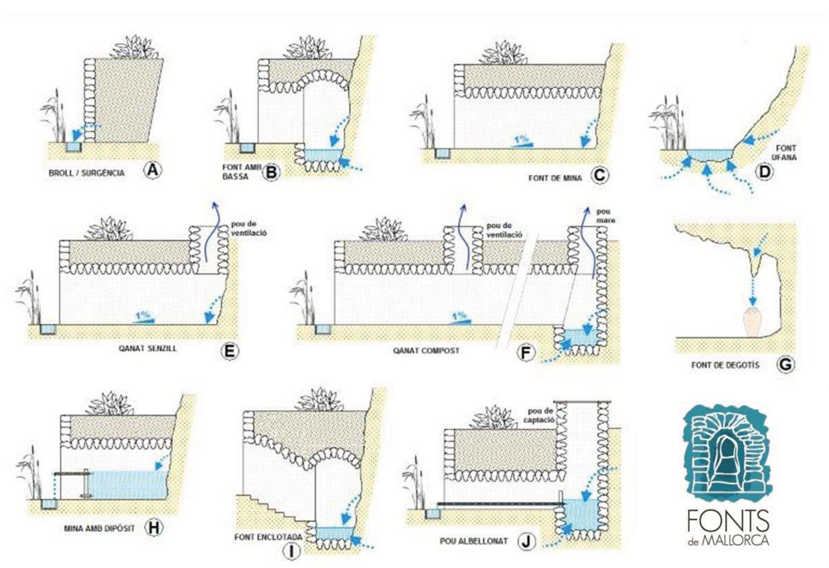
Figure 13. Classification of the springs in Mallorca proposed on the website. Modified from sites.google.com/view/fontsdetramuntana. See the definitions in the text.
Preprints 96238 g013
Our definitions of the concepts of font de mina (spring-flow tunnel) and qanat differs from those of other authors. For example, Ron (1985) defined qanats as any excavated water tunnel. In contrast, we consider the presence of at least one vertical shaft to be required for a tunnel to classified as a qanat. The absence of a vertical shaft represents, in our classification system, a spring-flow tunnel.
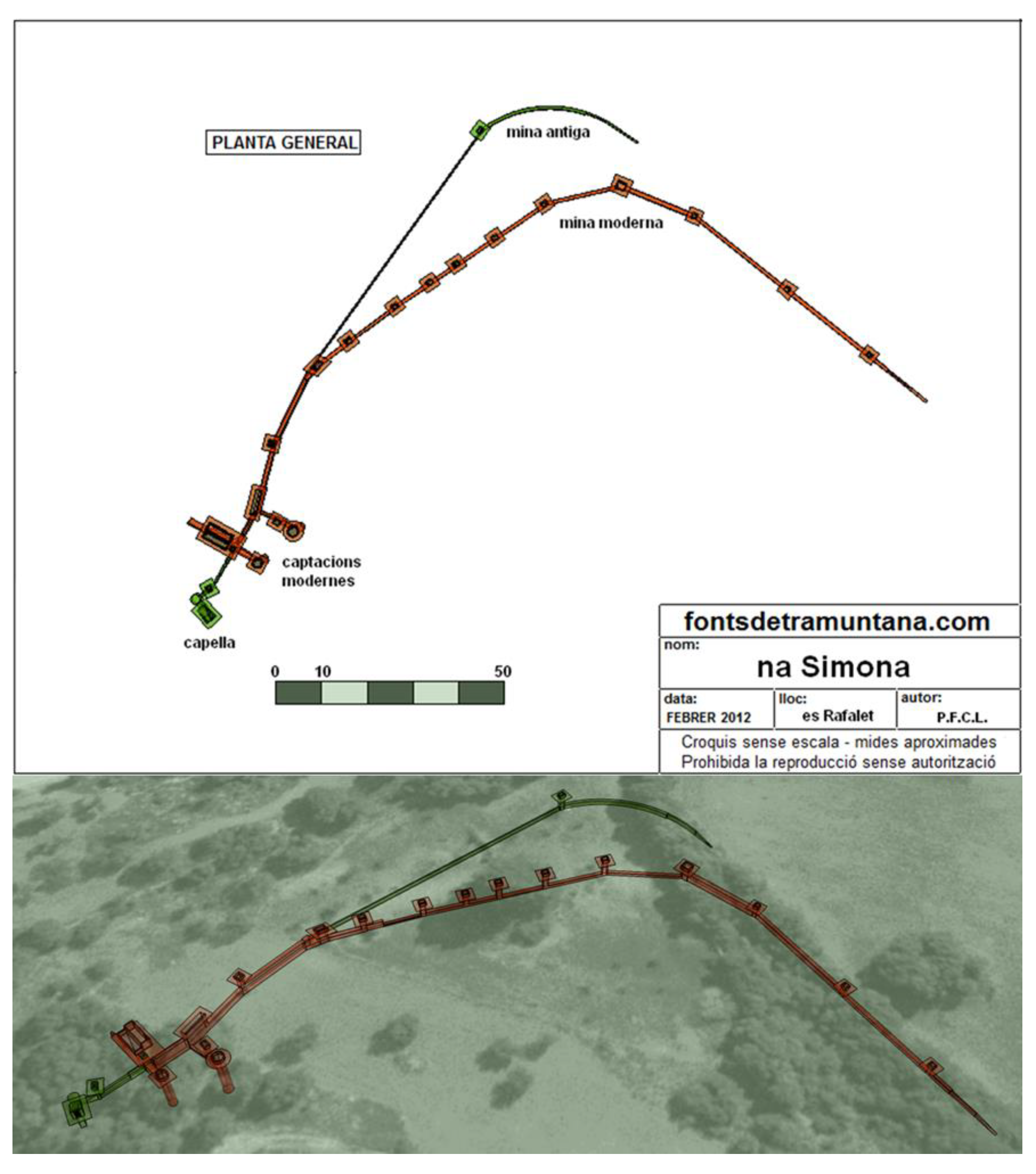
Morell (2019) indicates that there are 880 springs with a tunnel structure in the Tramuntana Range (62% of all the springs), of which 169 are qanats and 711 are spring-flow tunnels. Approximately 90% of these structures were constructed using the dry-stone building method, without any mortar binding. This technique allows the water to flow through the walls and usually prevents the collapse of the structure. Only some structures fixed during the 20th century have mortar on their walls. On rare occasions, the excavated tunnel has no protective wall, usually when it was excavated into solid bedrock.
The spring-flow tunnels are usually no more than 15 m long, usually straight, and perpendicular to the highest slope or with a slight curve. Also, the length of the mine is directly related to the average slope of the surrounding terrain. In flat areas the tunnels are much longer and vertical shafts are needed to provide air, construction material, or access to the tunnel for repairs. Thus, qanats are usually much longer than spring-flow tunnels, with some in excess of 200m long, with >10 vertical shafts (Figure 14).

Historical Evolution of Spring Structures

The location of Mallorcan springs is related to lithological and geological settings, but in many cases it seems that without the manmade structures, discharge to the surface would have been much less than it had been historically. Although the springs of Mallorca are traditionally associated with the era of Islamic domination (902-1229), there has been discussion on the possible Roman origin of some extant flow tunnels. Aguiló (2009) proposed a Latin origin of the toponym Xorrigo, where a spring-flow tunnel with that name exists, the name derived from sub riguus (standing for underground flow). In another case, the Font de Crestatx contains archeological remains that allow the origin of these structures to be dated to the first centuries A.D.
Many qanat and spring-flow tunnels have been directly related to the Islamic population of Mallorca. These springs appear in documentation from 13th and 14th century (first centuries after the Christian conquest) and have been subject to hydraulic archeology studies by Barceló & Kirchner (2003) among others. On the other hand, the springs recorded in the database are far more numerous than those cited in hydraulic archaeology articles. We found no relevant differences between springs clearly established during Islamic rule and others with well-documented construction during the following centuries. It is remarkable that the construction of a well or a spring-flow tunnel near a previously existing spring created many court cases related to the theft of water. For example, the case of the Font d’en Baster lasted for centuries (Gorrias, 2007) (Figure 15). Also, oral communications and local literature revealed that some Mallorcan spring-flow tunnels were excavated as late as the 1930s.
Many springs existed and remained perennial during the past centuries. Re-excavations and deepening of springs that had dried up during droughts or because of overexploitation were documented, but they were never abandoned or destroyed, simply retained for future recovery of flow. One well-documented example is the Font de Santa Margalida near Felanitx, Mallorca, which was originally an Islamic qanat that during the severe drought of 1490 and was subsequently deepened (Pino, 2020). On the day of Saint Margaret (20th July) its flow returned, and since then she has become a patron saint of the city. Only with the introduction of water-pump mills and extraction pumps in the late 19th century has the use of tunnels and qanats ended as a traditional water access method in Mallorca.

Uses and Structures

Among the most common uses of spring water is for crop irrigation. In some cases, the water was used for management of livestock, mainly watering, but also it served livestock indirectly through irrigation of fodder plots. Human need also was a common use of spring water, as long as it maintains a flow of sufficient quantity and regularity, and it is protected from livestock contamination.
In Mallorca, spring water had different industrial uses, mainly related to hydraulic engineering used to move mills with different functions, such as grinding cereals and legumes, beating or making paper pulp, However, it also had direct uses, such as improving oil production in the oil mill or simply watering threshing floors to flatten and minimize grain loss during threshing. Also, almost every town in Mallorca had a public laundry near a spring.
Uses that created the most complex and larger structures were related to irrigation. Every property that had a spring with regular flow, no matter if low, was used to grow crops, preferably vegetables. Although this has not been quantified, a study in eastern Mallorca in the late 19th century reported that 45 springs were used mainly for irrigation of 49.5 ha (Castro, 2013). That study also indicates that the five springs with greatest discharge were used for the irrigation of 33.1 ha whereas each one of the rest of the springs irrigated an average surface of only 0.4 ha.
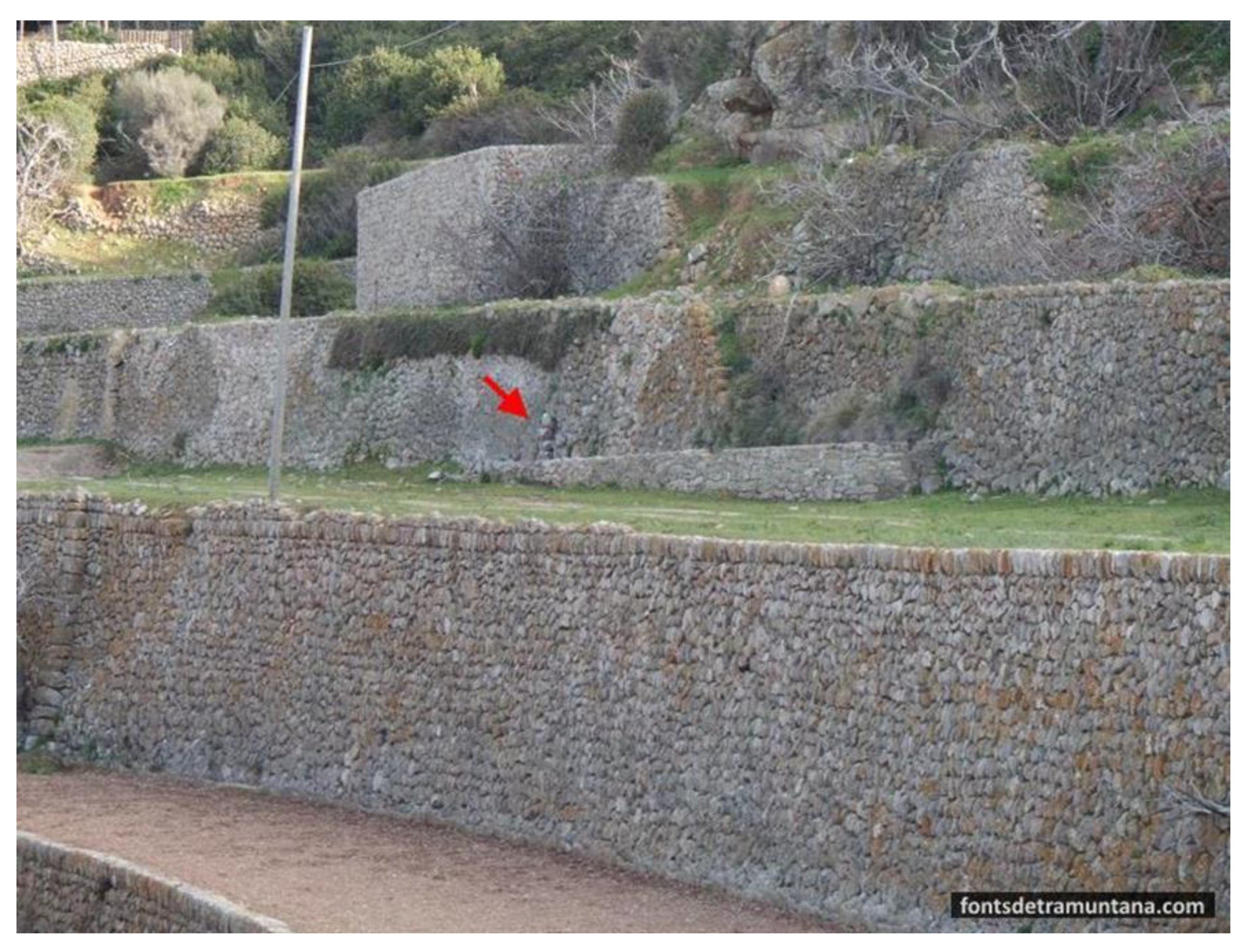
The same pattern was observed in the Tramuntana Mountains, where most of the springs used for irrigation irrigated only a limited area because of the low flow, but a few springs were associated with relatively large irrigated areas. All of these irrigated plots were characterized by much material heritage, as represented by stepped-terrain marjades (terraces limited by dry-stone walls) for conditioning steep terrain that extend across 194 km2, and also by canals, wash basins, troughs, laundries, and cisterns (Figure 16). Springs with limited discharge are often associated with troughs for animal watering, usually made of stone. However, there were reports of obis, troughs made with hollow logs at some springs, but none were seen by the authors.
Resting and recreational uses were only found in springs located within properties that could afford them. In some, artificial caves or grottoes were built at the exit of the mine, and stone tables and seats were installed to take advantage of the refreshing atmosphere (Figure 17).

Present Status and Future of Mallorca Springs

Many Mallorca springs have, at best, become places of leisure and tranquility, with uses completely different from those that characterized them since their creation. Even so, perhaps these are the ones with the best prospects of conservation, because they are receiving the most attention from the owners.
In most cases, springs located in more hidden places or far from inhabited places are completely abandoned. The abandoned springs continue to flow for some years, but the lack of maintenance causes the accumulation of sediments and the creation of limestone layers that finally cover the structures and clog the outflow. Therefore, the water itself is what ends up marking the collapse of the spring and condemns it to disappear over time.
The springs located in zones closer to inhabited areas have been drying up progressively during the last century due to the introduction of mechanical means for water extraction that lead to the drop in the phreatic level. In addition, the growing of tourism in Mallorca has resulted in long-term abandonment of farmland throughout the island. Where the crops still remain, the water is extracted, in many cases, from wells. On the other hand, in many of the springs that still keep flowing, the water has been piped along their entire route and, therefore, its surface expression has been eroded, leading to the disappearance of the associated ecosystems.
The Tramuntana Mountains area in Mallorca has the best chance of conserving at least part of the material heritage associated with springs, because crop irrigation is more difficult and groundwater depletion has been much lower than elsewhere. The declaration of the Tramuntana Range as a World Heritage Site in 2011 was mainly based on its cultural history, extending back millennia, as reflected to a large extent by the dry-stone structures linked to management of springs. On the other hand, the Tramuntana Range has also been declared a Natural Site and included in the Natura 2000 Network due to its ecological values. At this time, the balance between the protection of natural and cultural values requires careful planning because overprotection of the former could lead to forced abandonment of traditional uses and, therefore, the loss of the latter. If the use of springs is not allowed and encouraged using traditional methods, the current landscape will disappear as hundreds of spring ecosystems will degrade due to the clogging of mines, filling of ponds, and the destruction of the historic structures that allow the water to reach the surface.
In the east and center of Mallorca, on the other hand, the entry into the 21st Century does not offer positive perspectives for improving springs management, with many of them already dry or abandoned, if not destroyed by draining along with kilometers of canals that, for centuries, have been used to irrigate hidden corners throughout the island.

3.4.4. Discussion

The island of Mallorca is an archetype of Mediterranean life in relation to environment and history. Its rather small area prevents the existence of surface streams suitable to guarantee an uninterrupted water supply. In contrast, the presence of a limestone massif of certain importance (the Tramuntana mountain range) favors, on the one hand, an abundant orographic rainfall in winter season on the north of the island (Guijarro, 1986) and, on the other hand, the development of a karst system that allows the storage of excess precipitation in large underground water bodies (Gelabert and Sàbat, 2002). In this way, groundwater is the main - and almost only - water resource in Mallorca. It is not strange, therefore, that the springs have played a crucial role in the development of societies, probably since prehistoric times.
The spontaneous outflows of underground water are rather scarce in Mallorca, so that, when the technique of digging and building mines and qanats was developed, especially during the Islamic rule (Barceló and Kirchner, 2003), agricultural exploitation could expand to new places. This activity remained without significant changes until the 20th century and, as a result, the density of water points in the territory increased in a large extent, particularly in the Tramuntana range. In this massif, of just over 1000 km2, around 1400 springs have been identified and characterized, which are estimated to represent 95% of the potentially extant ones. It is important to mention that almost 900 of these springs are associated with underground galleries (mines and qanats) without which they would not flow. As for the rest, many of the springs also flow forcefully although with much more superficial excavations or drillings (such as a simple centimeter-sized hole). Thus, the vast majority of Mallorca's springs are associated with stone made structures (shelters, tunnels, canals, walls...) using the techniques of vernacular architecture. The number and monumentality of these structures, as well as their impact on the landscape, are enormous and have been crucial arguments for the declaration of the Tramuntana range (where most of the structures are concentrated) World Heritage. In addition, in a recent study in 10 springs of the Tramuntana range, an exaggerated biological richness in relation to its immediate environment has been demonstrated (Pascual et al., 2020). Also, spring habitats, thanks to the environmental stability they provide, are a refuge for endemic and threatened species (Jaume and Garcia, 1998).
From the second half of the 20th century, Mallorca has undergone accelerated change in the socio-economic dynamics, leading to the strong predominance of the tertiary sector and recession of agriculture and livestock production to residual levels. On the other hand, lack of time and will have led to the loss of most subsistence vegetable gardening, mostly irrigated by springs. In addition, in many of the springs that continue to be used, there is a progressive replacement of traditional elements with modern solutions that minimize water loss (open basins are replaced by closed cisterns, canals by pipes), removing the surface expression of water. In addition to the degradation of the traditional stone structures due to lack of maintenance, the habitats of the spring biological communities are also eliminated. In this situation, the disappearance of the springs in the center and south of Mallorca is at least in the near-term a permanent condition. Springs in the Tramuntana Range are more likely to persist. It is therefore essential to move towards active preservation of this heritage, which represents a unique and unrepeatable lesson on the relationship between man and the earth.
A strongly symbolic image of the ancient relationship between man and water in the generic sense comes from the science fiction film 2001: A Space Odyssey, a 1968 film produced and directed by Stanley Kubrick. At the beginning of the film, a group of hominids, led by a leader, barely survive in an arid and hostile environment. One day, the group of primates heads into the territory of another group to regain the previously lost waterhole. Water has long been a jealously guarded object of contention since the earlies origins of man (Cuthbert and Ashley 2014), and unfortunately is still at the heart of arguments across the social scale (e.g, wars for the “blue gold”).

3.5. Mediterranean Basin Case Study 3.1: North Africa

3.5.1. Introduction

The springs in the Arab Maghreb of Northwest Africa have not only quenched the physical thirst of the people but have also nourished their spiritual and cultural identity there by creating a harmonious combination of tradition, faith, and natural beauty. This enduring connection between springs and culture is a testament to the resilience of ancient practices in the face of changing times. In arid areas, access to water can become a catalyst for conflict, a challenge exacerbated by the effects of climate change (AbuZeid and Abdel-Meguid 2006; Angelakis et al. 2021).

3.5.2. Cultural and Religious Relationships

The springs in this region are closely interwoven with the cultural fabric of the Maghreb; their presence is not only felt but celebrated through various ceremonies and festivals. The landscape is adorned with springs bearing names such as Aïn Makhlouf (Makhlouf’s Spring), Aïn Beïda (White Spring), Aïn Berda (Cold Spring) and Tala Rana (Spring of Frogs), each with a unique history and meaning. Towns and villages bear these Arabic or Tamazigh names with pride and are a living testimony to the indispensable role of springs in the region. The thermal springs, in particular, are sanctuaries of relaxation and healing throughout the Maghreb.
In the spiritual realm, the connection between springs and culture is very close. In Islam, a cornerstone of Maghrebian identity, water symbolizes purity, leading many devout people or saints to find eternal rest near these life-giving springs or “holy” springs, each with its own history. This association gives these natural sites a sacred aura. Although the tradition of dedicating festivals to revered saints and the springs themselves has been criticized by Islamic purists, it dates back to the arrival of Islam in the region. Springs such as Kattara, the ‘oozing or leaking spring’ and Aïn Bent Soltane, the ‘spring of the sultan’s daughter’, near Annaba (Algeria) embody this enduring spiritual connection.

3.5.3. History

In addition, the ancient Roman heritage in the Maghreb has an extensive network of aqueducts, baths, and fountains that harness the power of the springs (Monteleone et al. 2007). The city of Hippone (now Annaba), for example, was supplied by Roman aqueducts that brought spring water from Mount Edough, and the fountains were decorated with large Gorgon masks made of white marble. The Zaghouan aqueduct and the Aghlabid cisterns in Kairouan, Tunisia, also show the Roman and Islamic influences on the region's water infrastructure. Cisterns, which have been used throughout the Mediterranean for thousands of years, have facilitated the management of seasonal fluctuations in water supply (Mays 2014).

3.5.4. Socio-economics

Finally, the art of foggaras is an essential part of the cultural and economic heritage of the Maghreb, especially in the arid regions of the Sahara. These underground aqueducts, which form an elaborate system of tunnels and canals, have significantly influenced the region’s culture and way of life. Beyond their practical use, the foggaras symbolize unity and collective effort. Their construction and maintenance require collective effort and promote the values of cooperation, shared responsibility, and mutual support among community members. In recognition of the importance of foggaras, UNESCO declared the knowledge and skills of their water measurers as Intangible Cultural Heritage in 2018.

3.6. Mediterranean Basin Case Study 3.2: Italy

3.6.1. Introduction

Many sites in Italy testify to the ancient connection between people and aquatic environments and, in particular, springs. One of the oldest testimonial is the prehistoric site of Poggetti Vecchi (Tuscany). The geological peculiarity of this site is the resurgence of thermal water springs along a fault contact between limestone and clay deposits. According to radiometric dating it was frequented by an ancient Neanderthal population around 171,000 yr ago in late Middle Pleistocene time, probably for the plant and animal resources that the thermal area offered in a period of climatic deterioration. Poggio Vecchi is one of only a few examples among European archaeo-palaeontological sites that reveals the transition from the Middle to the Upper Pleistocene, offering insight into the behavior of ancient Neanderthals. Sculpted boxwood sticks from Poggetti Vecchi represent an exceptional find, showing earliest evidence of fire being used as a tool for woodworking (Benvenuti et al., 2017; Arangure et al., 2018).

3.6.2. Archeology

This bond continues in the territory of San Casciano dei Bagni, which represents one of the richest geothermal regions in Italy, with a long tradition of use of its thermo-mineral springs. Groundwater temperatures range from cold water with low concentrations of mineralized calcium-bicarbonate to warm (>40 °C), highly mineralized waters enriched with calcium and sulphate. Studies indicate the recharge area in the Cetona basin and circulation in a highly fractured, aquifer formed in Mesozoic limestone, with an underlying aquitard of the Burano Anhydrite Formation (Piscopo et al., 2009). Archaeological investigations in sedimentary deposit associated with geothermal springs there recently produced a hidden treasure dating back to Etruscan times. In addition to coins, votive offerings and inscriptions, the discovery included 24 Etruscan-Roman bronze statues depicting gods, matrons, children, and emperors. Some of these discoveries included depictions of the god Apollo and Hygieia, revered as the goddess of health. The findings date from the 2nd to 1st century BC and suggest that the Etruscans considered water to have sacred values and that they appreciated its beneficial effects. At present, this is the largest find of statues from the Etruscan-Roman period (https://cultura.gov.it/bronziscasciano).
During the Roman era, hydraulic science reached its fullest expression when numerous imposing aqueducts, up to tens of kilometres long, were built to transport water from distant springs to urban centers. The selection of water for public distribution was made in relation to the origin of the springs, its transparency, taste, temperature, a permanent flow discharge, and most importantly an adequate gradient to get the water to the urban area. Water treatments were practically non-existent, being limited to simple decantation in limestone pools, special basins positioned along the conduit.
Remains of Roman aqueducts can still be seen in several Italian regions. In the imperial city of Rome, freshwater was provided by 11 aqueducts, altogether about 500 km long. These ensured that the city had enough water to satisfy the needs of a population of about one million inhabitants, including supplying public fountains and thermal baths. Of these 11, the Roman aqueduct of the Acqua Vergine (Aqua Virgo), inaugurated on 9 June 19 B.C., is the only one that has remained in uninterrupted function to this day, supplying parks, gardens, flowerbeds and artistic fountains in the center of Rome, such as the Trevi Fountain (18th century, Figure 18A), the Barcaccia in Piazza di Spagna (17th century, Figure 18B), and the Fountain of the Quattro Fiumi in Piazza Navona (17th century). Particularly in modern times, the Trevi Fountain has been immortalized in cinematic masterpieces. For example: 'Marcello Come Here' was whispered by an irresistible Anita Ekberg to catch the attention of Marcello Mastroianni in Federico Fellini's film 'La Dolce Vita', inviting him to bathe with her in the clear waters of the fountain. In a subtle movement, she baptized him. This iconic scene is etched in the collective memory of everyone, Romans and non-Romans alike.
The Aqua Virgo aqueduct collects spring water from an igneous aquifer (Pozzolane hydrogeological complex with basalts and tuffs) consisting of a complex of massive and chaotic pyroclastic flow deposits. The waters have a temperature of about 16-17 °C, are bicarbonate-calcic with a moderate concentration of salts, on average around 550 mg/L (Tuccimei et al., 2014).
Other significant examples of Roman aqueducts supplied by springs include the following.
  • The Catania aqueduct was 24 km long and extended from Santa Maria di Licodia to Catania at the Benedictine monastery of San Nicola. The aqueduct was one of the most demanding hydraulic engineering works made by the Romans in Sicily. The springs emerged at the base of a rock cliff of effusive basalts, and were channelled towards the city with enough flow to satisfy the needs of the population and the functioning of the numerous baths and naumachia at that time. Today, some of the springs that supplied the city of Catania in Roman times now feed the Cherubino Fountain, which is fed by means of a pipeline and was reconstructed by the Benedictine fathers in 1757 (https://www.romanoimpero.com/2019/10/acquedotto-cornelio-di-termini-imerese.html; Branca et al., 2011).
  • The Roman aqueduct of Olbia was built between the 1st and 2nd century AD. It was about seven km long from the springs of Cabu Abbas and directed via an underground pipeline to the baths of the ancient city. The source for these springs is a late Palaeozoic granitic aquifer.
  • The Church of Santa Fiora in Tuscany was built in the 15th century during the Renaissance period. Archaeological excavations there were conducted for reconstruction of the church floor, and can still be admired through some of the glass tiles on the floor (Figure 18C). This site shows the place before the church was built and the presence of a clear, perennial spring.
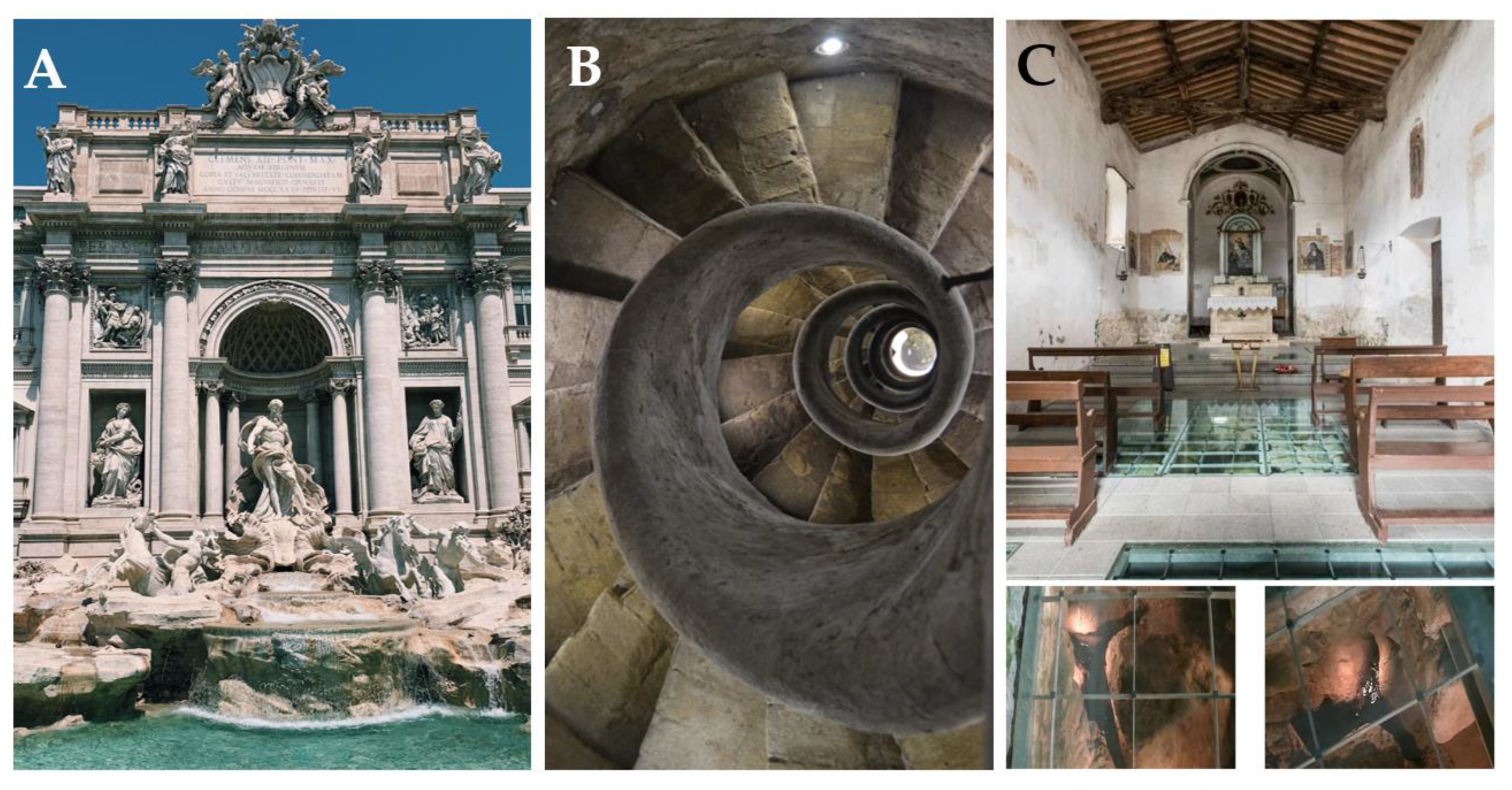
Figure 18. A: Trevi Fountain (photo credit =p.c.: Pexels); B: At the top of the Spanish Steps of Piazza di Spagna in Rome a 500 years old staircase leads 70m below to the Acqua Vergine (p.c.: pixabay); C: The floor of the Church of Santa Fiora (15th century). The glass tiles on the floor show th presence of clear spring water with a perennial regime (p.c.: S.S.).
Preprints 96238 g018

3.6.3. Literature

The springs also had a highly symbolic value in Italian literature. The Fonti del Clitunno (Umbria region) have enchanted and conquered artists and writers since Roman times. Throughout history, poets and writers such as Virgil, Pliny the Younger, Byron and Carducci have been enchanted by the charm of the springs, so much so that they are mentioned in their writings. In particular, Carducci, the first Italian to win the Nobel Prize for Literature in 1906, dedicated a poem written in the autumn of 1876 titled Alle fonti del Clitunno to the site. In these writings, spring water was considered the origin of every form of life, a symbol of rebirth and regeneration, a fertilizing element, a magical and therapeutic substance.

3.6.4. Contemporary Uses

Throughout the modern times, much effort has been expended to controlling freshwater supplies to avoid water being 'dispersed according to the caprice of nature'. Examples of such efforts are the Peschiera-Capore and the Campano aqueducts. The first was inaugurated in 1949, with work extending through the 1960s and completion in 1980. The aqueduct is fed by the Peschiera Springs that gush from the Monte Nuria area. The aquifer feeding the springs is composed of limestone in Triassic platform facies that have been affected by karstification. Half of their flow (9 of 18 m3/s) is captured to supply water to Rome. Le Capore Springs have an average flow of 5 m3/s and gush forth from a Meso-Cenozoic karstic carbonate aquifer (Martarelli et al., 2008). The second tunnel, in the Campania region, is fed by Biferno Springs on the Adriatic side of the Matese massif in Molise and by Torano and Maretto springs on the Tyrrhenian side of the same massif. The Matese karst massif is composed of limestone, dolomite and marl carbonate platform and scarp deposits of Triassic to Miocene age (D’Argenio et al., 1973; Leone et al. 2022). The minimum and maximum discharge recored in the area of Caserta and Naples by the Acquedotto Campano was 2,100 L/sec and 5,300 L/sec, respectively. The total length of this pipeline/aqueduct is about 580 km (Caracciolo 2018; Iacopini 2019).

3.6.5. Socio-economics

In more recent times, bottling water has become a significant industry, transforming spring water into a consumer and market product. Per capita, Italy produces and consumes the most bottled water of any EU country, with nearly 160 water bottling companies and >14 BL of water bottled/yr. This is equivalent to 10.5 times the volume of the Roman Colosseum. Meanwhile, in the mountainous sector of the Italian MCZ, springs continue to represent the traditional primary source of domestic water for rural Italians. Added to the ever-increasing anthropic pressure on the nation’s groundwater and springs are climate change impacts on the modern hydrologic cycle, with increased water crisis events induced by an increase in the frequency, duration and intensity of drought. This has led to increasing awareness by the public that its freshwater supply is not infinite. Instead, it is now more clearly seen as a limited resource that should not only be considered from a utilitarian point of view, but also more holistically. Spring water is not simply a commercial product, but is a patrimonial resource to be protected as critical 'natural capital'. Springs and the groundwater that feed them provide us with a multitude of ecosystem services that, although typically undervalued, are indispensable for local and national well-being.

3.7. Mediterranean Basin Case Study 3.3: Greece

Springs in Greek Mythology and Tradition

In Greek mythology female demigods under the collective name of Pigaiai Nymfai, were well-known personifications of natural forces. Not just associated with springs, they had the form of virgins who were considered the direct daughters of Zeus. Nymphs of springs were partially included among the Naiads, along with those of rivers, “fountains” and lakes.
The Waters of the River Styχ are the sources of the Krathis River in Helmos, Kalavryta District in Achaia at an elevation of 2100 m. The waters of the Styx were associated with chthonic theological and philosophical ideas, such as those from the Eleusinian Mysteries and Orphic beliefs about reincarnation. According to mythology, Styx was an Ocean woman who had her palace in Tartarus and was guarded day and night by sleepless dragons. It was believed that the waters of the spring came from there, from Tartarus, and the palace of Styx. In the waters of the Styx all the gods, even the Sun itself, swore an oath, the deepest oath a god could make, and there gods served their sentence when they were punished. It was said that any living being that drank from its water died, and any metal dipped in its waters melted. It was there that his mother Nereida Thetis plunged Achilles so that he became invulnerable, but she held him by his heel, the only vulnerable spot on his body.
Legends, traditions and mythical beings, such as the nymphs of antiquity and the soothsayers of folk tradition, were associated with waters of springs and rivers (Σουέρεφ, 2000). Greek nymphaea were religious structures constructed to honor the demigods that occupied spring sources. Initially these structures were modified natural grottos, but were subsequently designed and constructed as sometimes highly elaborate semi-circular temples, often with fountains. This tradition was adopted by the Romans, and examples have been excavated across the Roman Empire from Turkey to the British Isles (Geva 2023). The Nymphaeum of Jerash (191 AD) in Jordan is particularly exquisite. A nymphaeum was typically constructed at the inflow points of Roman aqueducts, and small nymphaea also were built as an alcoves or niches in individual houses. In addition to honoring the lesser gods, nymphaea served the function of protecting the emerging groundwater quality from livestock and atmospheric impacts, much as modern springboxes do throughout the world.
Springfed fountains were often constructed at nymphaea or on the occasion of establishment of settlements and churches, as well as for the creation of roads. Fountains were a main focus of social attraction, especially in villages as a daily meeting point for the female population. The space around them became a place for the performance of important ceremonies and folklore events, especially when the fountain had, or was thought to have, healing, magical or other properties, such as eugenics or eutecnia.
Many examples of springs with rich Greek histories are found in Italy. For example, Fonte Aretusa (Arethusa Spring) is located along the coast of the Mediterranean in Syracuse, Sicily (Figure 19). This site has been known since the 7th century BCE when the Greeks established a colony here. Arethusa was a nymph who was turned into a fountain by the goddess Diana to protect her from Alpheus, who was pursuing her. Her story and relationship to this spring is frequently mentioned by poets, writers, and travelers over the ensuing ages (e.g., Pindalo, Ovidio, Virgilio, and Ciceron;). Additional details about the site are provided in Polto (2001), Luzzini (2015), and Bouffier (2019).

3.8. Mediterranean Basin Case Study 3.4: Iberian Peninsula

3.8.1. Archeology

When humans abandoned their hunter-gatherer behaviour and established small settlements, they were located near places with easy access to water. In Mediterranean climate these places were often associated to a spring. The relationship of people with springs is especially strong in karst regions where, due to the permeable nature of the bedrock (carbonates, which are easily dissolved by water, have abundant pores, fissures and fractures), surface water is scarce during long periods of the year and springs may be the few places to access fresh water. It is therefore likely that ancient people, like at present, heavily depended on the springs.
The importance of springs in the establishment of human prehistoric communities has been shown all along the Iberian Peninsula. The karst springs of Malaga coastal locations had a crucial role for the rapid Mesolithic-Neolithic transition in the southern Iberian Peninsula (Cortés Sánchez et al., 2012).
In the western region of the Iberian Peninsula archaeological findings from prehistoric and Roman times reveal the use of spring water for medicinal or recreational purposes (Gonzalez-Soutelo 2005). In pre-Roman times, mineral springs were used but perishable structures were built, although votive inscriptions have been preserved in different sites (Gonzalez-Soutelo 2012). Likewise, in the Sicó massif, which covers an area of 430 km2 in the Portuguese western Mesocenozoic rim (central Portugal), relics that testify to human presence during the Mesolithic period are still visible, with many megalithic monuments scattered throughout the landscape (Jerónimo, 2015). In particular, Paleolithic artefacts and a Neolithic collective grave were found in inactive springs associated with Ourão spring (Silva, 2012).
Other examples can be found in the eastern Iberian Peninsula, in the case of Caldes de Montbui (Marcet, 1982), where the oldest remains date from the Neolithic (4500 to 2200 BC). Also, the relationship of the first settlers and springs has been suggested for the Empoadors spring at the foot of the Iberian wall of Montgròs in the Montseny Natural Park (Farrerons & Font, 2017).
Concerning the south and south-west of Iberian Peninsula, abundant remains have been found in the Ibero-Roman settlement of Fuente de la Loma, in Murcia (Fernández Tristante, 2023) or in Fuente de la Silla del Papa, in Tarifa (Moret et al., 2008).
The springs were a very precious asset in the settlements but also of great need in the ancient communication routes. On the Vía de la Plata (Extremadura), already used in the Tartessian era and later by the Romans, a large number of springs are located next to the route (Rodrigo & Haba Quirós, 1992), suggesting its use by travellers.
During the Roman period, the need for water increased with the growth of cities and this resource was brought from more distant points. In the Portuguese western edge of Iberian Peninsula, one of the most important springs during that period was Alcabideque spring, which gave name to the locality where it is located (Alcabideque, from the Latin “caput aquae” that means “head of the water”). Alcabideque spring (annual discharge: 16 million m3) contributed to the establishment of the nearby city of Conímbriga, which became one of the most important Roman cities in the occidental limit of the Roman Empire (Silva, 2012). Still today, it is possible to see the hydraulic system built by the Romans between 20 and 15 b.C., and which includes a reservoir where spring water was retained and a tower that covered a settling well (Castellum of Alcabideque); spring water was carried to the city of Conímbriga, 3 km away, by an aqueduct, which was buried for most of its length. As a testimony of Roman enginery, the Castellum of Alcabideque is classified as a National Monument, which highlights its historical and cultural interest (Figure 20A). In the opposite side of the Iberian Peninsula, an aqueduct conducted the water from springs –as well as nearby rivers- towards Tarraco (Costa Solé, 2011). Other large hydraulic engineering works built by romans include the water mines near Seville (Amaré et al., 2018; Naranjo, 2013).

3.8.2. Thermal springs and spas

In addition, the Roman expansion brought forth other uses of the springs. Spring water, especially that of thermal outflows, was already used by the Greco-Latin culture for healing and social purposes (Ruíz de Arbulo, 2011). The expansion of the Roman Empire generalized the use of baths throughout the conquered territory, including Hispania (Mora, 1981). In the Iberian Peninsula, there are records of about 50 archaeological sites related to spas, with a clear predominance of sulphurous or hyperthermal waters (Moltó, 1992). The geological and topographical context of the indigenous roads which were later improved by the Romans meant that these mineral-medicinal springs were used to create enclaves to facilitate the meeting point of the population using the waters (González Soutelo 2012). In the northwest of the Peninsula, where thermal springs abound, there are 4 AQUAE sites: Aquae Celenae (Caldas de Reis), Aquae Querquennae (Baños de Bande) (Figure 21B), Aquae Oreginae (Rio Caldo, Lobios) (Figure 21A) and Aquae Flaviae (Chaves) as road mansions in the territory of Gallaecia.
Particularly, a total of 39 springs in the ancient Gallaecia are of interest for their historical-archaeological context and, at least, five Roman buildings are associated to these waters (Lugo, Ourense, Carballo, Chaves and Caldas das Taipas) compared to the rest of the Iberian Peninsula (Caldes de Malavella, Caldes de Montbui, Archena, Alhama de Murcia, Fortuna, Fitero, S. Pedro do Sul, Alange and Baños de Montemayor) (Gonzalez Soutelo 2012). It is also in Roman times when an urban centre was vertebrated around the thermal springs (1st century b.C. - 1st century a.C.) of Caldes de Malavella and Caldes de Montbui. The Roman baths of Caldes de Montbui are the best-preserved of the Iberian Peninsula, although what remains is a small part of what must have been a huge thermal complex where different activities related to hygiene, leisure and therapeutic treatments were developed. Overall, up to 152 springs used during Roman times have been identified in the Iberian Peninsula (González Soutelo, 2013; Matilla Séiquer & González Soutelo, 2017), with at least 132 of them being spas (Figure 22).
Many of the Roman springs were later used by the Arabs during the Muslim occupation of the Iberian Peninsula, who introduced new techniques of mining and conducting the water. In some areas, the number of springs was significantly increased during the Muslim rule (see the case study 2, Section 3.4, in this article). This legacy has arrived to present times, as suggested by the Arabic prefix “Al” that remains in the names of several springs all along the Iberian Peninsula: Fonte da Ribeira de Alcalamouque, Fonte do Alvorge (Figure IB1.E), Fonte de Alcabideque (Figure IB1.A) (Portugal); Fuente Alfila, Fuente Alhama, Fuente Alquería (Andalucía); Fuente Altorruza, Fuente Almesaña, Fuente de Almazara (la Rioja); or Font d’Albió, Font d’Alsamora, Font de l’Albergada (Catalonia).
Most spas of Roman origin fell into oblivion for centuries, but experienced a late recovery towards the 19th century. Indeed, the rise of spas and the use of mineral-medicinal waters were broadly resumed in the Iberian Peninsula during the second half of the 19th century (Miranda Montero, 1984; Farrerons-Vidal, 2018). The increase in the bourgeoisie and its purchasing power favoured the proliferation of these establishments associated with sources of mineral-medicinal waters that supposedly offer health benefits. Aubán (1859) catalogued a great diversity of springs in Spanish territory (more than 250 baths) according to the mineralogical composition of their waters and established the different diseases (skin conditions, rheumatism, paralysis, neurosis, herpes...) to which are indicated for therapeutic use (see, in this article, case study 1, Section 3.3).
A good example of this process is the Roman baths of Trillo (Thermida in Roman times) in the center of the Peninsula (Guadalajara, Spain). The Romans and later the Arabs made use of these thermal baths, but in later centuries they fell into disuse and were abandoned. The recovery of the spa did not take place until the end of the 18th century, under the reign of Charles III. Pipelines were channeled, fountains were repaired and new ones were discovered, and a chemical study of the waters was commissioned. In 1777, the so-called Hydrological Hospital was completed, an institution to treat various ailments, notably arthritis and rheumatism, which was gradually expanded and also became a place of socialisation for the wealthy. At the beginning of the 20th century, after a period of decay, it became a sanatorium and leprosarium (Herrera-Casado, 1989 and references therein). Only recently the thermal baths have been restored and once again house a sumptuous spa. Another example is the complex of Caldes de Montbui (Catalonia) which, despite its enormous importance during the Roman period, fell into disuse and deteriorated over several centuries. It was not until the late 18th century, with the renewed boom in mineral-medicinal waters, that most of the baths and buildings were restored: notably, the waters that flow in Caldes de Montbui are of deep geological origin and are at a temperature of 74 °C, one of the hottest in Europe. In Portugal, Arrifana hot baths, two small springs with water temperature ~20 °C in Arrifana village, were used to treat skin problems, intestinal problems, and rheumatic between the end of the 19th and the middle of the 20th century due to the supposed therapeutic properties of their waters (Silva, 2012). In this case, therapeutic use of karst springs water in the region has declined, likely due to the development of thermal baths in nearby regions.
At the end of the 20th century, some establishments modernized and began to offer, along with the traditional curative use of water (Ledo, 1996), a broader range of natural therapies not based exclusively on it (López Morales, 2003; 2004). However, others lost a large part of their visitors and declined, often leading to their closure (Miranda Montero, 1984). Nowadays, stays in this type of establishment become a social event whose objectives are not only aimed at water therapies but also seek rest and tranquillity away from the hustle and bustle and stress of big cities.

3.8.3. Residential, livestock, agricultural, and leisure uses

Besides the historical evolution of spas and health resorts, springs have always been intensively used for other purposes by people living in Mediterranean regions because of the generalised lack of water. This is why small towns in rural areas, and farms that hosted one or several related families, traditionally settled close to rivers and, when those were lacking, springs. In dryer regions, people had to rely either on wells or water mines: horizontal wells that aim to increase the transmittance of the aquifer and release the water through a spring. This captured water would then serve for all possible uses: residential, livestock, and agricultural. Some high discharge springs are used to irrigate crop fields and, in some instances, to provide urban supplies: this is the case of Ourão spring (annual discharge: 25 million m3) which supplies water for domestic use to the Pombal and Soure municipalities and even had enabled the functioning of five water mills during the 19th century (Silva, 2012).
In small towns and villages, some of these springs were also used as washing places (Figure 23), where people gathered to wash clothes and other utensils, but also to talk and comment on any news or event that occurred in the town or the surrounding area (see also case study 1, Section 3.3). The importance that washing places had in this socializing role is well exemplified by some expressions, still deeply rooted in various Latin languages, such as “wash the dirty linen” (e.g., in Spanish ‘lavar los trapos sucios’) in relation to criticising or sharing other people’s intimacies in public, or “clothes are on the line” as a warning that one could not speak in front of a certain person, or a child. Even though this use has completely ceased, some of these washing places are still preserved or even restored (Figure 24). On the contrary, many other have been destroyed and the space used for other purposes.
Nowadays, the most common uses of springs are related to leisure, recreation and adventure. In mountainous regions springs provide water for hikers and excursionists. Some high discharge springs have become recreation attractions: such is the case of Olhos de Água do Anços spring (Figure 20B) which is used in summer for bathing and boating. Also, some karst springs have speleological interest because of their complex system of underground galleries and caves: Olhos de Água do Anços spring and Olhos de Água de Ansião spring (Figure 20C,D) have been explored by speleological diving up to 63 m and 70 m deep, respectively. The galleries associated with the Olhos de Água do Dueça spring were first explored by divers in 2003 and 2004 for 980 m and Olho do Tordo spring is also known to have 150 m of galleries (Silva, 2012).
On the other hand, some people still go to natural springs to collect water to drink at home. The springs used for that purpose are usually springs of soft water (low electric conductivity), with high rates of water flow and close to roads that allow visitors to park their cars and load them with water bottles. On the other edge of the spectrum, in terms of water chemistry, we find the naturally occurring sparkling water springs. The water of these springs often also contain high concentrations of other elements such as sodium, iron or manganese, and have since mid-19th century, have been believed to have healing properties for a wide array of diseases (see above in this section), even though high concentrations of some of these elements (e.g., manganese) are now well known to be harmful.

3.8.4. Biodiversity hotspots

In last decades several scientists have highlighted the importance of springs as biodiversity reservoirs. Providing a biotope with permanent water and highly constant thermal settings, springs are both hot spots of biological richness and refuge for endemic and threatened species, especially in Mediterranean and other dry climates. This has been recently demonstrated for karst springs in north-eastern Iberian Peninsula and nearby islands (Majorca) (Pascual et al, 2020). Another interesting phenomenon related to the constancy of environmental conditions in spring habitats concerns the river nerite (Theodoxus fluviatilis), which reaches densities as high as 9000 individuals/m2 in Olhos de Água do Anços spring (Graça et al., 2012). Inhabiting these springs, where water temperature is constant at ~16 °C year-round, the snails reproduce continuously, and small individuals are present throughout the year. This contrasts with the snail reproductive phenology in environments subject to seasonal fluctuations in temperature across its geographic distribution where egg capsules laid in Spring hatch 2–3 months later but those laid in late Summer go dormant until next Spring as embryonic development stops at water temperatures below 10 °C (Kirkegaard, 2006). Environmental stability has also been important in the choice of springs as places to preserve endangered vegetal species, as for example Vallisneria spiralis and Groenlandia densa in Arrifana spring, or even for reintroducing regionally extinct taxa as Nymphaea alba and Nuphar luteum in the same spring, in the framework of FloraReply project .

3.8.5. Legends and myths

Being springs tightly linked to the history of humanity it is not surprising that they are often present in mythology. The oldest references to legends and myths about springs and their waters date back to ancient Greece and Rome. Nymphae, young maidens with divine essence, were the inhabitants of many of them (e.g. Arethusa in Ortigia, Peirene in Corinth), and the Romans already celebrated an annual festival, the Fontinalia, dedicated to these beings (Ruiz de Arbulo, 2011).
In postclassical Europe, nymphae are transmuted into fairies. For centuries they were popularly supported, but they acquired great relevance during Romanticism when they were narrated by writers such as Gertrudis Gómez de Avellaneda in “La ondina del lago azul” or by Gustavo Adolfo Bécquer in “Los Ojos Verdes” inspired by medieval stories (Martos García & Martos Núñez, 2014; Diaz Tena, 2005). Legends and stories about ondinas, damas de agua, lamias, lamiñaku, mouras, encantadas, dones d'aigua, lloronas, … are spread throughout the geography of the Iberian Peninsula (Martos Núñez & Martos García, 2011).
The relationship between nymphs and humans is, on many occasions and depending on the place, contradictory. Sometimes it is suggested that the waters protected by them have a healing nature, while in others, it is stated that bathing in them is prohibited and carries serious consequences (Díaz Tena, 2005; Rocas Sumoy, 2022). Sometimes the ladies or nymphs try to make humans fall in love with their songs to use them sexually and then destroy them (Mas i Gibert, 2009). In the case of “Los ojos verdes” (The green eyes) that Fernando de Anglesola sees reflected in a spring and with which he falls in love, they are not those of a fairy but those of the devil in the form of a woman (Bécquer, 1861).
The deep roots of these myths among the population have led to many toponyms based on them. They are common in the Iberian Peninsula: Fuentidueña, Fuensanta, Fonsagrada, Fuente de la Xana, Fuente de la Lamia, etc. (Martos García & Martos García, 2015; Martos García & Núñez Molina, 2023). Later, the nymphs, fairies and damas de agua are Christianized in Virgins (Martos Núñez & Martos García, 2017) and the places dedicated to virgins and saints.

3.9. Mediterranean Basin Case Study 3.5: Turkey

3.9.1. Introduction

Türkiye is geologically and topographically heterogenous and has climate zones: Mediterranean, Continental and Oceanic. Mediterranean climate is characterised by precipitation levels <200 mm during the summer months (Akman and Ketenoğlu 1986). Türkiye‘s MCZ occurs on its southern coastlines on the Mediterranean Sea in Muğla to Antakya provinces. The Taurus Mountains rise abruptly from that Mediterranean coast, reaching >3700 m in elevation, and increase humidity in the region. As elsewhere, Türkiye‘s Mediterranean climate is characterized by mild and rainy winters and hot and dry summers along the coasts, as described by Atalay et al. (2014).

3.9.2. Structural Geology

Geologically, two main fault systems that influence groundwater storage and emergence, the North Anatolian and East Anatolian faults (Duman et al. 2018) (Figure 25). Numerous hot springs arise along these faults near Muğla (Köyceğiz). Many soda springs emerge near the Lakes Acıgöl and Salda, and sulphur springs emerge around Lake Burdur northwest of Burdur in the Mediterranean Region. In contrast, the cities of Antalya and Mersin are rich in karstic springs (e.g., Kırkgöz, Olukköprü, Boğsak and Aydıncık springs) (Xanke et al. 2022).

3.9.3. History

Throughout history, hot springs have been important in Anatolia and the rest of Türkiye. In ancient time, Hieropolis (the “Holy City”) was founded as a thermal spa in southeastern Turkey in what is now Denizli Province (Üreten 2006). Its buildings were primarily constructed from springs-deposited Pamukkale (Cotton Palace) travertines in the late 2nd century BCE by the Attalid kings of Pergamom. In addition to its spa and balneotherapeutic functions, wool was scoured and dried there. On-going excavations at this World Heritage Historical Site have revealed Greco-Roman temples, monuments, baths, and other archaeological finds, including a nymphaleum. The area is also renowned for having a large system of canals that delivered water to surrounding communities and agricultural fields, with flow extending about 70 km northwest to the Büyük Maíandros (now the Menderes) River, which is spring-sourced and is the longest river to reach the Aegean Sea.
The Pamukkale travertines used to build Hieropolis provide an excellent example of interactions among tectonic and seismic forces that influence aquifer development and direct groundwater movement and emergence in springs (Hancock et al. 2000). Travertine deposition occurred in and around the Hierapolis Fault zone as a result of degassing and precipitation of CaCO3-enriched geothermal water in >20 fault-controlled fissure ridges. Blocks of vertically banded fissure travertines (ornamental “Phrygian marble”), as well as utilitarian bedded travertines were quarried from the plateau downslope from the city, with each narrow quarry excavated into a nearly vertical fault fissure. As a result of its tectonic extensional setting, the contemporary hot pools and active travertine deposition are located just downslope from the fault alignment.

3.9.4. Cultural Aspects

Alexandria Troas was founded close to Kestanbol Hotsprings in Çanakkale Peninsula (Demirsoy et al. 2018). During the period of the Ottoman Empire, the Turkish Bath practice known as “Hammam Culture” became regarded as important for body treatments. In this concern, kese (a special glove for peeling), pestemal (a kind of traditional towel for hammam), tellak (a specialist trained in hammam), and olive soap are traditionally used (Hahn 2016). Beside its health and healing properties, hammam is also important in socialization, as those who visit hamam feel refreshed after the bath and massage. Moreover, they are able to speak about daily life events (politics or sport) with their tellak during the massage.

3.9.5. Economics

Each year, the geothermal energy industry in Türkiye has been growing by developing more geothermal power plants to produce electricity and heating systems for buildings and greenhouses. The counrty has now achieved important geothermal developments over the past decade (Mertoğlu et al. 2019) and now is seventh in the world in terms of its geothermal potential (Balat 2006). About 12% of Türkiye’s geothermal potential has been appropriated thus far for direct use and geothermal electricity production, 17 cities are heated, at least in part, by geothermal energy (Mertoğlu et al. 2019). Lying in the Mediterranean Region, the Province of Muğla contains multiple hotspring systems, with Lakes Köyceğiz, Alagöl, Sülüngür and Koca in Köyceğiz, and Fethiye-Göcek Bay (Avşar et al. 2017).
Besides geothermal sources, there are many mineral springs in Türkiye because the country is geographically located in the tectonically active Alpine-Himalayan belt. Mineral water is important for healthy of the body, and waters enriched with calcium and magnesium are regarded as good for bone, nerve, and muscle development (Tuluk and Cengiz 2017). Many famous mineral water companies exist in Türkiye because mineral springs abound in different regions of the Anatolian Peninsula. Economically, some springs are important for their use in producing bottled mineral water.
Overall, water is an essential part of Türkiyish culture, society, and economics. Clean freshwater is essential, representing purity and playing an important cultural role in birth and end-of-life events throughout the Anatolian Peninsula. Some of the countries large cities have been founded near the springs over the nation’s long history. Springs have long been, and are still used for balneotherapy. And with advancing economic and technological development over the past decade, geothermal springs are increasingly being used as an inexpensive source of energy in individual buildings, for greenhouse operations, and in urban communities.

3.10. Case Study: Springs of the Western Cape, South Africa

3.10.1. Introduction

The Western Cape, like many other regions of South Africa overlaying some of the oldest geology found in the world, is endowed with numerous cold and hot springs, which have served humans and nature since immemorial times. The Western Cape is special in a historic sense, as this is where an important economic centre and melting pot, Cape Town, arose between the pre-existing indigenous culture and the new culture infused by colonization and the discovery of the trading route to East India south of the African continent in the second half of the 1600s. With the naval expeditions of the time and influx of settlers, first the Dutch (the so-called voortrekkers), and later the British, there was an increasing need for water, which early on was provided by natural cold springs originating from Table Mountain in the centre of a growing town, the ‘Mother City’, or Camissa - the ‘Place of Sweet Waters’ (The Water Wheel, 2010), as it was called early on. It would grow to become a major metropolitan of South Africa, not only due to its maritime strategic location (which incidentally dwindled with the advent of new travel routes and means), but also because of fertile lands, spectacular natural scenic beauty, good water resources, and a pleasant climate. Until 1891, the whole of Cape Town’s water supply came from springs from Table Mountain (The Water Wheel, 2010). The city relied on intricate capture, conveyance, and storage systems for freshwater spring flows, only to lose their significance due to waste, pollution and poor upkeep. The canals fell into disarray, as modern technology for damming rivers improved, and water was increasingly developed in the hinterlands and transferred through large canals to the growing city as well as to an expanding agricultural economy dependent on irrigation (The Water Wheel, 2010).

3.10.2. Hydrogeology

The Western Cape Province counts on approximately 13 hot springs (Boekstein and Spencer, 2013), while the city of Cape Town in and by itself has about 70 identified freshwater cold springs of variable size (City of Cape Town, 2018), including about a dozen larger ones, harnessed in fountains (Harris et al., 2010) (Figure 26). The springs of both areas are of meteoric origin and associated with recharged rainfall emanating as springs via fractures, structural features, or geological dislocation zones of the hard rock formations. The Cape Town groundwater and springs are generated from rainfall on Table Mountain (Figure 26a), which consists of a well-lithified sandstone located as a massive formation in the centre of the city.
As opposed to the cold springs, the hot springs of the province are linked to the Cape Fold Mountains, a large zone of parallel mountain ranges generally composed of sandstones and shales that curve along the southwestern coastline of South Africa about 200-300 km inland (Figure 26b and Figure 27). The hot springs are located as a string of pearls on the outer edge of this fold, indicating that the interface between impermeable underlying formations forces groundwater into emergence as springs, often in narrow fissures or sheets (Olivier and Jonker, 2013) (Figure 28). The hot water of the thermal springs is due to adiabatic (i.e. pressure processes), as infiltrating water is compressed during the flow to deeper zones, while the cold springs of Cape Town are more superficial and not influenced by these processes. While the residence time of the springs is not well-established, it is assumed that the age of the springs partly correlates with temperature, reflecting the depth of penetration of the water (Olivier and Jonker, 2013), implying that hot springs could be older than cold springs in similar geological settings. Water from the Cape Fold thermal springs is, however, relatively young, the residence of the Baths Springs estimated to about 2 kyr (Mazor and Verhagen, 1983). Most of the hot springs remain relatively temperate with the hottest, Brandvlei Spring, reaching 64°C (Olivier and Jonker, 2013). Despite the longer residence times and higher temperature of the water of the hot springs, giving rise to higher levels of interactions with the aquifer material, the natural seeps from the hot springs belong to the defined spring class of low mineral content (Olivier and Jonker, 2013). The Cape Town aquifers are mostly fresh with good drinking water quality (if protected) (The Water Wheel, 2010).

3.10.3. Cultural Significance

The indigenous, pre-settlement cultures of the region, importantly the Khoekhoe and San peoples, contracted into ‘Khoisan’, reportedly discovered the curing properties of the region’s springs from animals, who were observed seeking shelter and refuge for healing in the springs.
Besides the importance of the natural cold springs of Cape Town, an important factor in the early colonization of the Western Cape and in the establishment and growth of the city was an interesting linkage to the hot springs. The geothermal waters were not sought for water supplies, but for their balneotherapeutic properties. The hot springs located to the east but within reach of Cape Town rose in importance as settlers, travellers, and ‘Indian invalids’ (those injured in East India during their posting there) took advantage of the documented healing properties of the springs (van Wyk, 2013). Initially these hot springs were just dugout holes close to the spring discharge sites on public land, excavated by the Indian invalids themselves. There, they could bathe and take mud baths. Eventually, those sites were developed into sanatoriums on private land, where balneotherapy businesses associated with these geothermal resources expanded over the years (van Wyk, 2013) (Figure 29). The health and wellness culture associated with mineral thermal waters that was important to the ancient Greek and Roman cultures was hence also adopted in South Africa, indirectly via the British. Over the years, this stimulated a considerable tourism industry with visitors coming to enjoy the natural springs and the pleasant Mediterranean climate of South Africa (van Wyk, 2013).
Today, the hot springs of the Western Cape still play an important role in the medical, heath, and nature tourism, while also assessed as having undervalued and undeveloped potential (Olivier and Jonker, 2013; Boekstein and Spencer, 2013). These aspects of tourism, both domestic and international, can be significantly developed. While the natural and rustic properties of springs are highly appreciated by those regularly visiting hot springs, a general consensus exists that more infrastructural improvement and additional amenities can be developed to expand visitation and enhance visitor experience. A more concerted support to the thermal wellness industry could importantly also spark socioeconomic development in some of the smaller communities in the region, with spillover effects to other sectors (Boekstein and Spencer, 2013). Some of the thermal springs could also serve alternative or additional purposes, like in agriculture for greenhouse heating, or for aquaculture (Oliver and Jonker, 2013), thereby increasing local livelihood opportunities.
A cry for water was sparked with the 2018 Day Zero crisis in Cape Town (Figure 30), generating discussion of incorporation of natural freshwater springs into the public water supplies. Despite the fact that the Cape Mountain springs did play a significant role in supporting water supply during that dire drought, especially for the poor (Figure 27) (Cape Town Magazine, 2020; Baker, 2018), development of these water resources was not considered a feasible path to help solve the city’s water needs and help avert another similar crisis in the future (City of Cape Town, 2018). The amount of water produced by natural springs in the region is relatively small (about 6 mega L/day (Willmore, 2015), as compared to the total production needs of the city of about 800 mega L/day (Western Cape Government, 2023). This water is mostly captured for non-portable use (firefighting, irrigation/landscaping/golf courses) (The Water Wheel, 2011) and for the most part discharged via stormwater systems into the sea through underground tunnels in the city (City of Cape Town, 2018). A significant cultural heritage, which arose centuries back, is considered lost, and cultural, environmental, and human rights activists are working to reverse this challenge (reclaimcamissa.org). Groundwater, from boreholes and wellfields and private wells, plays an increasingly important role in the Western Cape. The practice of augmenting groundwater through artificial recharge is increasing (LaVanchy et al., 2019), but will have uncertain impacts on groundwater supplies and the ecosystems and biodiversity they support.

3.11. Case Study: Southwestern Australia

Australia has largely uncoordinated drainage across the southern and western two-thirds of the continent west of the Murray-Darling Basin where Mediterranean climate is predominantly experienced. Rivers are usually short and coastal, as much of the continent lacks high mountains. Prolonged lack of coordinated drainage inland has led to the accumulation of salt in catchments and chains of salt lakes along paleoriver drainage lines are a feature.
Consequently, springs are widely scattered in parts of south-western Australia that enjoy Mediterranean climate. Only a few place names include the word ‘spring’ e.g. Three Springs north of Perth. Mound Springs are virtually absent from southern Western Australia except near Bullsbrook to the north-east of Perth, at Three Springs and at Gnowangerup north of Albany. Today water sources for human consumption come predominantly from underground aquifers and surface pools along rivers, creeks and in lakes. Recently desalination of sea water has been adopted to provide the growing metropolis of Perth with fresh water.
The W.A. Naturalists Club reports that the Swan Coastal Plain mound spring on the Gnangara mound, west of the Ellen Brook and the Darling Scarp is situated over a series of aquifers (including the Yarragadee) from which some of Perth’s potable water is extracted in drought times (https://www.wanaturalists.org.au/mound-springs/, accessed 15 December 2023). “This mound spring site has broad zones of peat ~100 m wide. It has eight vegetated springs over an area covering just 21ha from Bullsbrook to Mundijong. The mound springs have a tree storey of Swamp Banksia (Banksia littoralis), Paperbark (Melaluca preissiana) and Flooded Gum (Eucalyptus rudis) with lower storeys comprised of ferns and sedges, and amongst the non-vascular plants are bog clubmosses and liverworts.” The community is threatened.
Springs are known from right in the heart of Perth, e.g. at the bottom of Spring Street, at a place known to the local Nyungar Aboriginal people as Goondinup (from goodinyal = cobbler fish), an important camping ad fishing place. Less than a kilometre further west, at the foot of the Kings Park escarpment adjacent the Swan River, Kennedy’s Fountain was another important source of fresh water for drinking, still flowing today. It is significant to the Aboriginal people because it is the home of the mythical Rainbow serpent the Waugal to Whadjuk Nyungars. It became Perth’s first public water supply fountain.
On Western Australia’s south coast, beeliar (fresh water, and also mother’s milk) constitutes one of two key attributes in Noongar culture for life (Knapp cited in Silveira et al. 2021). Perhaps the most significant testament to the ongoing cultural significance of springs to Noongar people in southern Western Australia is the aptly named Wagyl Kaip or rainbow serpent’s water (Figure 31). The Wagyl (strictly waar = breath, and karl = fire) is the ancestral being that formed landscapes and waters across Noongar boodjar (country). The Wagyl Kaip native title agreement area embraces six of Tindale’s (1974) dialect groups – all of the Minang, and parts of Koreng, Kaneang, Wilman, Wudjari and Pipelmen. A seventh group, not recognised by Tindale (1974), the Mirningar Bardok, has lands overlying most of the Wagyl Kaip boodjar.
Regarding springs, great cultural significance is placed on what we term the original Wagyl Kaip, a vital water source named Vancouver Spring by nydiyang (white people) that sits adjacent to Frenchman’s Bay in King George Sound flanked by Kinjarling (Albany – Figure 31). Inland people call the WagylMadjit,’ so Madjit Kep is also used for the spring, but the Merningar apply Madjit (strictly Maartyuirt = hand white) to the white pointer shark. Wagyl kaip has always been a vital water supply going back to the earliest people, the Kalamia, who lived at Kinjarling when forced upslope to the Kalamia Hills (above today’s Goode Beach) by rising sea levels. The Wagyl kaip spring became Albany’s main water supply soon after settlement in 1826, and subsequently served whaling interests as well as provided water for steamships from the mid 1800s.
There are other forms of spring-like water sources on Noongar boodjar. Night Wells fill up only at night and drain away in daylight. One near Borden where Nightwell Road crosses Peenebup Creek is called by Goreng people Kep Waam Win Barkep (=water, to and fro, being that which [is] rock water). The creek bed is salty but overlying granite pools (gnamma) filled in the night with fresh water until nydiyang applied gelignite to enlarge the gnamma. The Knapp Merningar family always used night wells, ubiquitous along the southern coast, to avoid possible poison placed in open-water ponds and pools.
The town of Gnowangerup is famous among Noongars for its elevated springs known as Gnowwanyirup. Gnow is the mallee fowl (Leipoa ocellata), wan means nest, yir means elevated and up is place of. The allusion is evident when one encounters a mallee fowl nest (Figure 31). Today the spring’s emergence and downslope movement of water are constrained by concrete works.

3.12. Case Study: California

3.12.1. Introduction

The United States has many large and small cities that include “spring” in their name, and famous spring attractions are found in cities in New York (Saratoga Springs), Virginia (Warm Springs), Arkansas (Hot Springs) and over 200 other areas. However, none of these areas match the cultural association of the springs in the Mediterranean region of California because the geology of this area has resulted in all the spring types long ago described for the state (Waring 1916), including: hot springs, carbonated springs, sulphur springs, saline springs, and springs described by their predominant and sometimes unique mineral components such as magnesium, iron, and lithium. This diversity results from the volcanic activity in this region and the resulting waters that are rich and diverse in their mineral composition (White et al 1973). Gasith and Resh (1999) described the Mediterranean climate region of California as including coastal areas, the Central Valley, and the foothills of the Sierra Nevada. However, most of the information about cultural activities associated with springs comes from spring habitats located in the Coastal Mountains of this region.

3.12.2. Indigenous Use

The use of springs extends in California’s Mediterranean climate region back at least 12,000 years when native Americans moved into Coastal California (Benke et al 2022). Folklore, spirits and deities, healing, and even the occult have been associated with these springs by indigenous people. With the arrival of Europeans, water diverted from springs enabled the expansion of agriculture through irrigation, and eventually they also became a source of recreation, healing, and entertainment. In the 19th century, recreational and health resorts were developed in the California coastal region, but these declined in use by the early to mid-20th century. Today, the revival of interests in springs are often centered on alternative healing approaches emphasizing health cures and meditation practices Altman 2000), luxurious relaxation (Young 1998), and even centers for recovery from drug addictions (Jaco 1990).
From ancient times, the traditions of ancient people have often centered on springs that had certain attributes that made them sacred. Anthropological evidence has suggested that for many native Americans, waters emerging from springs were viewed as coming up from the center of the earth and they provided a view or window to the nether regions of their universe. For some groups of native Americans, hot springs were thought to be warmed by the breath of the great spirit.
California springs have been viewed to be sites where powers of rejuvenation, cures, and spiritual activities occur. Springs were gifts of the great spirit that contained magical beings who could both heal and destroy. Entering them was shrouded in ceremonial practices, decorum, and respect. In the Coastal region of California, the Coastal Miwok people were well studied by Alfred Kroeber (1925) and their use of the springs has been described in several sources (e.g., Callahan 1965, Klages 1991). The Miwok used some springs as seasonal camps, along with the springs providing paths to healing and spiritual realms. Men of some tribes used earth, wood, and stone to build dams and direct water from hillside springs and collected these waters in pools for bathing.
Klages (1991:54-55) describes the way rituals were conducted at Harbin Spring, which is in the Mediterranean-climate coastal region: “To a shaman, the waters of a hot spring were an entrance way to the underworld. In a trance state, induced by meditating on such a point of entrance—a natural tunnel, rock crevasse or spring—the shaman could travel from the material world to the spirit realm. There he could talk to the spirits and do healing work which, when returning to a non-trance state, he brought back to the people of his tribe. Since these natural openings to the spirit world are rare, the springs were a very special and sacred point in the already sacred material world”. Sick tribal members were bought to the springs for healing. Today, spring water for health purposes is called balneology, in which natural springs are used for the prevention and cure of disease.
Multiple tribes often used the same camps and springs. Klages (1991) suggested that Harbin Spring, described above, was a place of peace with several coastal tribes such as Pomos and Wappos and that they used the same springs. However, while the springs were used year-round, it is not known if different tribes shared the same springs at the same time, or bathed with only their own tribal members, and whether genders were mixed. Similar encampments were made by the Patwin and other tribes at nearby Wilbur Hot Springs.

3.12.3. History

With the arrival of the Spanish settlers and the establishment of missions in the coastal mountains of California in the mid-18th century, the culture of the indigenous people of the Mediterranean region of California was often corrupted or lost. This was true for much of the ceremonial nature of springs of this region as well. At this time, whole villages of Miwoks and other native Americans were moved to missions This planned action opened land to Spanish settlement and provided a workforce for agriculture (Benke et al 2022). Conversions to Christianity affected the traditional spiritual life of these tribes as well as reducing the spirituality that they associated with springs.
The discovery of gold in the Mediterranean-climate region of California in 1848 led to huge increases in populations in San Francisco and led to the development of new cities in this area. Some of the immigrants to the region, either through mining success or entrepreneurship, became members of the middle and upper class, and sought new leisure activities.
In the 1850s and 60s, well over a score of resorts were built around springs throughout coastal California (e.g., Hoberg 2007). These centers of relaxation may have been affected by the popularity of facilities in the eastern part of the United States such as those in New York (Saratoga Springs), West Virginia (Sulphur Springs), and Arkansas (Hot Springs). These resorts combined relaxation and access to springs for drinking the waters and for bathing, and were accompanied by the availability of food, gambling, alcohol, and the perceived health benefits from soaking in the springs and “taking the waters”. The rise of these resorts in some ways resulted in the return to these springs being viewed as important amenities of nature and spirituality and at the same time provid economic benefits to the owners.
Famous spring resorts built at this time included Vichy Hot Springs, opened in 1854 and popularized by the patronage of writers Mark Twain and Robert Louis Stevenson who described the “bubbly champagne waters” of these springs. Newspaper accounts of visits by US Presidents Theordore Roosevelt and Ulysses Grant increased public awareness of them as fashionable resorts. These springs have only moderately warm temperatures, 32 °C, but purportedly had curative power for nervous disorders, heart, stomach, and kidney problems.
The waters of Wilbur Hot Springs had high Sulphur concentrations whereas Indian Spring was famous for mud baths where volcanic ash and water were mixed in a slurry in which patrons were covered up to their necks. The latter spring is in Calistoga, California. Reportedly, the name was a slurred pronunciation for Saratoga, the famous New York spring resort. Tassajara Springs and Esalen springs, both sulfurous springs in the Big Sur mountainous coastal area, were close to the Pacific Ocean. There, the waters and the magnificent views drew people from San Francsico and Los Angeles. They are still popular sites for meditation, retreats, and seminars on alternative lifestyles. And health practices
The coastal California resorts have many popular culture anecdotes associated with them. The Geysers Hot Spring Resort was owned by two Curry brothers, and it was successful in the late 1800s. However, a feud caused them to split as partners with the older one insisting on taking this successful Geysers resort as his, and to turn concession rights for an area in the Sierra Nevada called Yosemite Falls to his younger brother. The Geysers is long gone as a resort and now the site of geothermal energy development. The Curry Company still operates concessions and housing at the hugely successful Yosemite National Park.
By the early decades of the twentieth century, these resorts became dilapidated, burned down from fires, or abandoned. The influx of workers to the San Francisco Bay area in the 1940s increased use of these resorts as weekend-holiday centers because of their closeness to San Francisco. The facilities of one resort, Byron Hot Springs, was turned into a prisoner of war camp for captured German officers during World War II. But by the 1950s, spring resorts in the Mediterranean region of California were largely a feature of the past.
The 1960s were a time of revolutionary ideas and changes to lifestyles in the United States because of the upheavals of the civil rights movement, Vietnam-War protests, and new views of life choices. California, and especially San Francisco, was the center of many of these changes. The “Hippie Movement,” “New Age Movement,” the “Summer of Love,” and the “Human Potential Movement” were all centered in California’s Mediterranean climate region. The sites of old spring resorts often were occupied by religious cults and became communes. Gurus, from elsewhere or locally produced, attracted young people and the use of psychedelic drugs such as LSD became commonplace in these spring dwellings.
However, entrepreneurs also saw the chance to capitalize on these movement and many of the abandoned resorts such as Wilbur Hot Springs and Harbin Hot Springs were reconstructed and opened for both bathing and relaxation and health, but also became popular for other activities. For example, Wilbur Hot Springs opened a “Cokenders” residence program to treat drug- and alcohol- addicted clients (Jaco 1990).
Some resorts were rebuilt as luxury spas (Kaysing and Kaysing1993, Young 1998). New facilities were built, sometimes in rustic but more often in modern-resort style, and natural spring pools were sometimes diverted into modern swimming pools. Meditation programs, yoga, and various massage treatments were developed, one of which features watsu massages conducted using water movements to do the messaging (Klages 1991). These specialty treatments became popular features of the modern spring resort and drew large crowds. Weekend programs featuring celebrity chefs and gourmet meals became popular attractions.
Hot tubs originated in California and mimic the practice of bathing in spring water. The company that first developed these items was in the small coastal California community of El Cerrito that previously had specialized in producing irrigation pumps. Today, hot tubs are often associated with the “California lifestyle" but are popular in private homes and hotels throughout the USA and tourist areas of the world.
Indigenous peoples used springs for health and spiritual practices for thousands of years. These attributes of spring water have now been reinstituted in the commercial practices at the spring resorts of today. With the anticipation of more leisure time from shorter work weeks, less commuting time, earlier retirement, and interest in alternative health cures, the use of springs in the Mediterranean region of California will persist and even expand in the future.

3.12.4. Bottled Water

Drinking water from various springs in this Mediterranean-climate area was a millennial long practice, and it is typical for brand names to specifically mention the springs in the coastal region from where the water was sourced. Calistoga, for example, the city where many of the spring resorts were originally located and now reopened, is just one of many examples of this capitalization on the mystique of springs. These location-labelled bottled waters are popular, even where drinking water is of high quality and taste (Royte 2008, Gleick 2011). Of course, the cost of bottled water from these springs far exceeds the cost of gasoline per volume!

3.12.5. Energy

Hot spring areas also became important as sources of geothermal energy for production of electricity. Fields of hot springs and fumaroles (steam releases from springs) in California have attracted many entrepreneurs and companies interested in geothermal energy production (Hurwitz 2022). Hopes were high for this alternative source of electricity. For example, in the late 1970s, it was anticipated that geothermal sources would be sufficient to supply 10 % of all Northern California’s electricity requirements. However, the geothermal fields soon became overexploited.
The largest geothermal energy site in the USA is The Geysers Geothermal Field, a 80-km2 valley located ~120-km north of San Francisco, and that area supports 18 geothermal energy production facilities. Energy at these geothermal plants is primarily produced directly from steam directed into turbines. Many geothermal plants recycle used groundwater back into the aquifer, and at The Geysers treated wastewater from nearby Santa Rosa is injected back into aquifers to replenish diminishing groundwater supplies. The name Geysers is a misnomer; no natural geysers are known in California.
Potential impacts of geothermal development result from the release of spring waters having chemistry that greatly differs from surface waters have long been studied (Resh et al 1984). Many of the biological effects are the result of thermal rather than chemical attributes of the geothermal effluents (Lamberti and Resh 1983) but the latter can have specific effects because of the uniqueness of the water’s chemical composition.

3.12.6. Biology

The spring areas of California’s Mediterranean region are also known for their endemic biological fauna. One species of insect, the Wilbur Springs Shore Bug, was the first aquatic insect proposed for listing as a U. S. Federal Rare and Endangered Species (Resh and Barnby 1987) and others certainly are candidates for listing because of their endemicity linked to the unique water chemistry of springs in this area (Barnby and Resh 1988).

3.13. Case Study: Moapa Warm Springs

3.13.1. Introduction

More than two dozen warm springs arise in the uppermost portion of Moapa Valley northwest of Glendale in Clark County, southern Nevada USA. The springs emerge at the terminus of Nevada’s intermittent White River from groundwater that has traveled beneath 11 endorheic watersheds over 200 km a groundwater pathway that has taken 10,000 yr (Winograd and Thordarson, 1975). Those springs now provide baseflow to the 51 km-long Muddy River (Stevens et al. 2020). The Muddy River originally was a tributary of the lower Virgin River, but now flows into the Overton Arm of Lake Mead reservoir. The Moapa Warm Springs are renowned for supporting a diverse suite of endemic fish and aquatic invertebrate species, and for their peculiar management history.

3.13.2. Archaeology and History

With archeological remains in the region dating to >8,000 yr ago, the landscape was occupied in pre-historic times by hunting and gathering early Desert Archaic peoples (Altschul and Fairley 1989). Excavation of a corn cob and other archeological remains dating to about 200 CE indicate an early start for agriculture in the region, which likely helped support the Lost City several tens of kilometers downstream, a large settlement of Uto-Aztecan western Early Pueblan culture (Harry and Watson 2010). The region was abruptly abandoned about 1200 CE, and the region subsequently colonized by the Shoshonean Nuwuvi (Moapa Band) of the Paiute Tribe. Spring Rock Shelter in Warm Springs may have been used by the Band to avoid capture by Spanish slavers.
Explorer Antonio Armijo linked the Northern Route of the Old Spanish Trail in the vicinity of Moapa, helping develop a trade route from Santa Fe, New Mexico to Los Angeles, California. That route passed about eight miles southeast of Moapa Warm Springs and from there went on to Mountain Springs Pass through the southern Spring Mountains on what is now the west side of Las Vegas. The region was opened up to settlement after it was accessioned to the United States in 1846. Mormon settlers moved into the region and began farming and ranching after about 1850. At that time, an outlaw from Texas named Alexander Dry who raised stolen cattle became the first rancher in the area. Following settlement of the valley by Mormon farmers in the latter half of the 19th Century, the Nuwuvi Band was provided with a reservation there. At the beginning of the 20th century two large ranches occupied the area, and they were merged in 1950 to form Francis Taylor’s Warm Springs Ranch. During that interval, Washintonia filifera fan palm trees, which are native to the California desert but not to Nevada, were introduced.
Part of the area was purchased by Howard Hughes in 1971, who continued agricultural activities and also built a resort, complete with showgirls and springfed swimming pools. After Hughes passed away in 1976, the Mormon Church purchased the ranch, retaining a 30 ha parcel as a retreat, but subsequently selling 494 ha to the Southern Nevada Water Authority in 2007, which named their new holding the Warm Springs Natural Area. Bob Plummer of Las Vegas purchased a 40 ha parcel containing warm springs and constructed the Desert Oasis Warm Springs Retreat as a family-friendly resort, which operated until 1994. A large portion of the valley, including Desert Oasis and the Mormon retreat were burned in a wildfire that year. Del Webb purchased the property in 1997 and transferred ownership to the US Fish and Wildlife Service as part of the Moapa Valley National Wildlife Refuge to help protect the sensitive aquatic species there.

3.13.3. Site Ecology

Six major spring complexes occur in the headwaters valley, including: Cardy Lamb; Baldwin; Big Muddy (on the 30 ha Church of Jesus Christ of Latter-day Saints retreat); and three complexes on the Warm Springs National Wildlife Refuge (the Plummer, Pederson, and Apcar complexes). These warm (not “hot”), mineral rich springs support many unique, unusual, and some endangered species, including: fish - the only populations of federally Moapa speckled dace (Rhinichthys osculus moapae), Moapa White River springfish (Crenicthis baileyi moapae), and endangered Moapa dace (Moapa coriacea) and endangered Virgin River chub (Gila seminuda; in Muddy River); aquatic Mollusca - Moapa pebblesnail (Pyrgulopsis avernalis), Moapa Valley pyrg (Pyrgulopis carinifera), and grated Tryonia (Tryonia clathrata); aquatic aquatic Hemiptera - Moapa naucorid (Limnocoris moapensis; Figure 32), Pahranagat naucorid (Pelocoris biimpressus shoshone), Western naucorid (Ambrysus mormon); aquatic beetles - Warm Warm Springs crawling riffle beetle (Haliplus eremicus), Moapa riffle beetle (Microcylloepus moapus), and Moapa Warm Springs riffle beetle (Stenelmis moapa); terrestrial insects - MacNeill sooty-winged skipper (Hesperopsis gracielae); as well as the only population of limewater brookweed (Samolus ebracteatus) known in the Colorado River drainage (SEINET 2023). In addition, six Neotropical migrant bird species, seven bat species, and desert tortoise (Gopherus agassizii) are sensitive species that do or used to occur in the valley.

3.13.4. Conservation

In accord with its mission, the US Fish and Wildlife Service has maintained WSNWR and conducted several major rehabilitation efforts to protect the complex assemblage of endemic and endangered fish and aquatic invertebrates living there. First, the resort was dismantled and the swimming pools removed. By 2000, the non-native fan palms had almost entirely colonized the site, to the extent that the springbrooks emerging from the Plummer and Peterson Warm Springs complexes flowed only over palm root crowns, not reaching the ground. Furthermore, non-native tilapia, other predatory fish, and mosquito fish were ascending Muddy River and threatening native fish and aquatic invertebrate populations. The US Fish and Wildlife Service engaged a team of us to inventory springs, remove most of the palm trees, and construct gabion fish barriers to exclude non-native fish from the spring sources. They also established nature trails and an exceptional outdoor stream-tank aquarium viewing area where the visiting public can see the native fish and endemic springsnails in their natural habitat. Thus, this inland Mediterranean climate site has become one of the best examples of biodiversity conservation though improved springs management.

3.14. Case Study: Chile

3.14.1. Geography

Central Chile’s Mediterranean climate landscape is tectonically, biogeographically and culturally extraordinary. It occurs in a long thin strip of land that extends from sea level, discontinuously over the Central Coastal Mountains and into the Chilean Central Valley, and up to 6893 m at the top of Mt. Ojos de Salado at 27 °S along the crest of the Andes. The MCZ in Chile occupies more than 100,000 ha, approximately 35% of the country. The northern extent of the MCZ lies in Chile’s District 5 (Valparaiso Region) just south of La Serena at a latitude of approximately 32 °S. It extends south to District 8 (Bíobío Region) just south of Concepción at about 38 °S along the coast. The MCZ extends into Chile’s Central Valley, and farther inland to the south and into Argentina. Annual mean precipitation is highly variable, ranging from 300-800 mm/yr, decreasing by nearly 40% from the coast to the Central Valley. High temperatures reach 35 °C in December and January. As of 2023, the population of the MCZ was approximately 14 million people, 75% of Chile’s total population of 18.5 million (CIA 2007). Of that total, nearly 12% of the total Chilean population was indigenous, primarily Mapucheans.

3.14.2. Geology

With uplift of the Andes beginning in mid-Mesozoic time as South America separated from the rest of Gondwanaland, the geology and geomorphology of this western coastal MCZ has been the result of tectonic interactions, most recently between the Pacific Nazca Plate, the South American Plate, and the Antarctic Plate. The Nazca Plate is subducting under the South American Plate in the Peru-Chile Trench, which reaches a maximum depth of 8065 m and has a movement rate of nearly 9 cm/yr. Northward forcing of the Nazca Plate is occurring at its boundary with the Antarctic Plate, with the Chilean Triple Junction expressed at the Taitao Peninsula on the southernmost end of the MCZ. Consequently, the Chilean MCZ is a topographically complex landscape with much recent and active volcanism and frequent seismic activity. This landscape configuration produces many relatively short, steep rivers, which are commonly baseflow sourced at lower elevations by geothermal and coldwater springs.
Three relatively large rivers flow through the Chilean MCZ. The 380 km-long Biobío River is the second longest river in Chile, and reaches the Pacific Ocean at Concepcíon in the Bio Bio Region (VIII). Terme Avellno is a streamside hot spring in the middle reach of the river that has been encircled in concrete to provide recreational access during different mainstream flow stages. The 240 km-long Rio Maule reaches the sea at Constitucíon in the Maule Region; and 3) the 250 km-long Rio Maipo flows through Santiago. All of these rivers head in the Andes, but are fed by many geothermal and coolwater springs, some of which have considerable value to indigenous cultures and to the recreation industry.
While terrestrial geology (particularly that of the northern mining districts; e.g., Evenstar et al. 2017) has been intensively studied, exploration of the mineral deposits associated with seafloor vent springs (“black smokers”) or in diffuse sedimentary deposits (e.g., on the floor of the Antarctic-Nazca plate boundary) are in their infancy (German et al. 2022). Such seafloor vent spring mineral deposits are attracting the attention of the mining industry and may initiate future socio-cultural changes along the Chilean coast.

3.14.3. History

Multiple indigenous cultures occupied the MCZ in pre-historic times, including the Mapuche, Picunche, and Cunco peoples, with peripheral presence of the Chiquiyane, Pehuenche, Puelche, and Aonikenk cultures. However, most of the indigenous population in the MCZ was, and remains the Mapuche Culture, with lesser populations of Ayamara and Diaguita cultures. The Inca occupied northern Chile, including the northern portion of the MCZ down to the Maule River from the 15th and early 16th centuries, just prior to the arrival of the Spanish. With the conquest of the Incan empire by genocide and European diseases, Spanish rule was initiated in Chile. The CIA World Factbook (2023) summarizes subsequent Chilean history thusly: “The Captaincy General of Chile was founded by the Spanish in 1541, lasting until Chile declared its independence in 1810. The subsequent struggle became tied to other South American independence conflicts, with a decisive victory over the Spanish not being achieved until 1818. In the War of the Pacific (1879-83), Chile defeated Peru and Bolivia to win its current northernmost regions. By the 1880s, the Chilean central government cemented its control over the central and southern regions inhabited by Mapuche Indigenous peoples [restricting them to small reservations, as their lands were sold off for exploitation]. Between 1891 and 1973, a series of elected governments succeeded each other until the three-year-old Marxist government of Salvador Allende was overthrown in 1973 by a [CIA-coordinated] military coup led by General Augusto Pinochet, who ruled until a democratically elected president was inaugurated in 1990. Economic reforms, maintained consistently since the 1980s, contributed to steady growth, reduced poverty rates by over half, and helped secure the country's commitment to democratic and representative government’” (CIA 2023, with insertions by LES).

3.14.4. Vegetation and Ethnobotany

The vegetation of the Chilean MCZ has been studied with considerable intensity, and compared to the extraordinarily similar Californian MCZ vegetation, as well as other regions with a Mediterranean climate (e.g., Fox 1995). The Chilean MCZ lies at the southern border of the Neotropical Region in the Chilean Winter Rainfall-Valdivian Forests Region (Arroyo et al. 2004). The coastal areas are vegetated by matorral: sclerophyllous, evergreen shrub and subarborescent tree vascular plant species and with some succulents. Endemic species in this habitat include at least multiple endemic species: Adesmia bedwellii, Austrocactus spiniflorus; high elevation Chaetanthera flabellifolia and C. incana; and Cactaceae Eriosyce armata, E. coimasensis, E. eriosyzoides, E. marksiana, and E. senilis (Reiche 1907; Royal Bot Garden Edinburgh 2023). The Chilean matorral differs from California’s chapparal by supporting columnar cacti like Trichocereus chiloensis, Puya bromeliads, and scattered Jubaea chilensis palms.
Mooney et al. (1970) report that, like California, the Chilean MCZ between latitudes of 30⁰ and 40⁰ supports vegetation along a dry to moist aridity gradient that transitions from semiarid shrublands with succulents, to evergreen shrublands, to a broad-leafed evergreen woodland/forest. In a comparative study of MCZ vegetation patterns on two continents, they note that while the elevational gradient in Chile is progressively depauperate, that in Californian Mediterranean climate zone increases in species richness. This is likely due to the narrower piedmont area, longer annual dry period, and the restrictions of fog-based precipitation in Chile as compared to California (L. Stevens, personal observations).It also may be related to disturbance frequency, as California chapparal is strongly and regularly prone to wildfire, while Chile is not, except in developed areas like Valpariaso, where introduced fire-tolerant Eucalyptus is abundant and contributed to a disastrous fire in April 2014.
Many plant species in Chile have ethnobotanical and food value. León-Lobos et al. (2022) conducted a national review of reported edible plants and the manner of use. They reported that 330 (7.8%) of the nearly 4300 plant species in Chile were useful as food, primarily by indigenous cultures. They reported consumption of fruits, roots, and leaves on 196 genera in 84 families. The most species-rich families were Apiaceae, Asteraceae, Cactaceae, Fabaceae, and Solanaceae, and the most common edible growth forms were perennial herbs, followed by shrubs, trees, and annual or biennial herbs. León-Lobos et al. (2022) also compared their data with other countries, of which that with Spain (another MCZ) demonstrated a similar percent (5.9%) of potentially edible plant species. One species known at MCZ springs, such as the Laja complexes (below) is known as nalca, pangue, or Chilean rhubarb (Gunnera tinctoria). With leaves approaching 2 m in width it is conspicuous but sometimes difficult to harvest. The long leaf stalks can be cut down and stripped peeled, and either eaten fresh or boiled and turned into jam.

3.14.5. Chilean Springs and Recreation

Although many aspects of Chile have been well studied, the cultural relationship associated with spring ecosystems have received little attention. While many springs are appropriated for domestic and agricultural use, the recreational and balneotherapeutic values and economics of hot springs are among the best known of such relationships. About 20 km east of Antuco in Chile’s BioBío Region (VIII), the Manantiales de Laja (North and South; Figure 33) springs produce most of the perennial headwaters flow of the Rio Laja. The southern springs emerge at the crossing of the Sendero las Chilcas and the northern springs emerge a few hundred meters to the north, both in Laguna de Laja National Park. One or more recent eruptions of the 2979 m-tall Volcan Antuco stratovolcano dammed the Laja Valley between 1624 and 1869, creating Lago Laja lake. Water from the lake moves beneath the natural basalt flows dam, emerging about 7 km to the southwest in massive gushet springs complexes. The springs are a popular tourist attraction and support abundant madicolous habitat and dense cliff-wall wetland and riparian vegetation, which stand in marked contrast to the sparsely vegetated volcanic adjacent upland landscape. Most of the headwaters flow of the river is diverted downstream for agricultural purposes by multiple communities along the river.
Many other hot springs exist throughout the Chilean MCZ; however, mapping data and information on the economic value of visitation have yet to be discovered by us. One recreational hot spring of note is Termas Geométricas Hot Springs (Figure 34). This complex contains >60 springfed pools and waterfalls, with temperatures ranging up to 80 °C. The springs complex was modified ove the past two decades into a work of modern structural art designed by architect Germán de Sol (https://www.germandelsol.cl/memtg.htm) to facilitate visitor movement and enjoyment of its many soaking spots through this steep and topographically complex, tectonic landscape

3.14.6. Conclusions

Chile lies in a globally recognized biodiversity hotspot, and much of that area of concern lies in the MCZ. Approximately 40% of Chile’s vascular flora is endemic (Arroyo et all 2004), and a hig proportion of its vertebrates also appear to be threatened (Marquet et al. 2004). Nonetheless, there appear to be few endemic plant species in Chile that are springs-dependent. This pattern is similar to that noted in California by Stevens (2023), but who also commented that intact California springs support a disproportionate percentage of rare plant species. In contrast, many California springs and those in other desert regions support high numbers of endemic invertebrate and fish species (e.g., Fensham et al. 2023b). Phenes raptor (Petaluridae) (Figure 35) is one of only 10 species remaining in this oldest, most ancestral lineage of dragonflies. It is Chile’s largest dragonfly and flies over low-order, dashing streams in at least the southern MCZ (LES, personal observations). Studies of this rare group are few, but in the California Pacific Coast MCZ its petalurid larvae are reported to live along helocrenic wet meadow edges in vertical burrows, emerging nocturnally to feed on land. LES also observed several large species of stoneflies (Plecoptera) in springfed Chilean streams. However, given the generally low level of information on Chile’s spring ecosystems, the extent of rare, endemic, or culturally significant biota in those habitats has yet to be determined.

3.15. Case Study: Northwestern India and Eastern Himalaya

3.15.1. Introduction

Mediterranean climates occur in northwestern India, northern Pakistan, and elsewhere in the western Himalaya. Springs here play essential roles by providing water for drinking, irrigation, fish hatcheries, hydrogeology, and ecosystem and biodiversity sustenance throughout the Himalayas. There are roughly three million springs in the Indian Himalayan Region (IHR) (Niti Ayog, 2017) that serve as the source of drinking water for over 200 million people. An estimated 80-90% of the Himalayan population depends on springs for domestic water use (Scott et al. 2019). The states of Jammu and Kashmir, Himacahal Pradesh, and Uttrakhand are known for their Mediterranean climates and extensive network of springs, numbering in the many thousands. Springs are embedded in multiple landscapes and offer a variety of ecosystem services, including drinking water. Historically and culturally, spring water is preferred for drinking as compared surface water because spring water is believed to be clean, pure and having a good taste, and healing properties. Spring water is of great importance in guaranteeing the domestic water supplies of urban, rural, and mountain residents, and in supporting social, economic development, and maintaining ecological balance.

3.15.2. History and Culture

The protection of springs is not a new concept: people and societies have managed and maintained springs in their own ways and according to their own needs and beliefs for millennia. The Hindu community’s religious beliefs have been a driving force in protecting springs. The Muslim community constructs mosques near springs to ensure availability of water for religious purposes, and protects and maintains those springs. In Nepal, springs are safeguarded with stone and concrete walls and are fenced with wire and trees to restrict access (Sharma et al., 2016). Some springs there are locally protected based on religious beliefs linking their origin to the Snake God (Nag). That community fears that polluting these sacred sites could lead to disasters like landslides. Most springs worshipped for the Snake God are close to settlements, and their water is either pumped and stored in nearby cement tanks for distribution or directly piped to households (Chapagain et al., 2019). The use of gravity-flow system (GFS) tanks to store spring water from remote sources represents an important strategy in Bangladesh's water resource management. This approach underscores the importance of harnessing spring water efficiently to address water scarcity challenges (Nowreen et al., 2023).
It was formerly a cultural practice in the Himalayan region to fence springs, especially those used for drinking, bathing, or washing purposes. That fencing was normally constructed of branches and cloth material was sometimes used to signal its location or priority for protection from livestock entry. This practice has now been replaced by governmental or community programs to protect water sources using concrete and iron grills. During winter in Kashmir, springs were preferred destinations for bathing and washing as their constant water temperatures were somewhat warmer than ambient conditions. In most situations spring waters were diverted from upper slopes down to a wooden conclave (srankut) was built for bathing. Clearing of the spring was a rural community task involving selection of one day every six months or year when a designated person would replace damaged fencing, remove litter nd unwanted macrophytes, and clear out sediment. Community participation is key to these efforts, integrating traditional knowledge with modern scientific approaches (Ghimire et al., 2019).
Springs hold deep cultural significance in Himalayan communities and are featured in local rituals and heritage. Springs are frequently marked by temples and stone sculptures, such as gomuk' that resemble animal heads, particularly in the Western Ghats (Erschbamer, 2021). In the Himalayas, miniature step-wells (naulas) are constructed to facilitate and focus seepage while offering storage and protection of springs by constructing a stone wall around it. Local communities predominantly own, use, and maintain these structures as communal resources, with minimal intervention from the state (Verma and Jamwal, 2022).

3.15.3. Springs Distribution

The region is blessed with thousands of springs preferably; however, exact numbers are not known, despite many studies conducted in Himachal Pradesh, Uttrakhand, Jammu and Kashmir states. In Kashmir valley freshwater springs are widely distributed (Figure 36 and Figure 37), occurring both in high altitude areas and on the plains. Across the length and breadth of the valley, there are numerous springs acting like stars of the sky providing freshwater all year long. The majority of these springs are small and occur in private land ownership. This has led to springs being modified, polluted, and overlooked in conservation and management planning. Many springs have vanished over the past few decades, as witnessed by the communities there, and the present-day distribution and number of springs is less than that which existed previously. However, the extent of those losses is not known. Despite a long history of spring research across globe, including in the Himalayas, and a growing intensity of scientific research (Lone et al. 2020; Bhat et al., 2022) and public concern, credible inventory and classification of spring ecosystems in the region is lacking.
In Kashmir Valley, few researchers have worked on spring ecosystems, with the most comprehensive effort conducted by Bhat et al. (2022). Those authors provided a comprehensive database of 254 managed springs distributed throughout the Kashmir Valley. The effort in this direction about latest inventory on spring ecosystems in Kashmir valley was also made by the Public Health Engineering Department Jammu and Kashmir wherein they have provided district wise enumeration of spring ecosystems. However, this estimate is related to springs used for supplying and having potential for drinking water supply and does not report on small springs, which greatly outnumber the above category. The latest spring inventory conducted by Bhat et al. (2023, unpublished) revealed the presence of more than 3000 springs from the different districts in Kashmir Valley (Figure 36, Figure 37 and Figure 38). A closer look of those data revealed that the maximum number of springs are observed in Budgam, Kulgam and Anantnag districts (Figure 36). Springs have been documented in Tawi basin Jammu region including hot springs of Ladakh (Figure 39 and Figure 40).

3.15.4. Economic Importance

Many water supply schemes in Kashmir are sourced from springs, such as those in Verinag, Kokernag, and Achabal, and springs are the preferred water for propagating trout in Kashmir (Figure 40). These springs are known as dhara, mool, kuan in the central and eastern Himalayas and nag, nagin, chashma and naula in the western Himalayas. Springs in these lands are important not only for utilitarian purposes, but also in relation to religious and cultural activities. In addition, springs serve as tourist destinations for nature lovers from all over the world. Many fish farms in the Kashmir valley rely upon springs and many villages obtain most of their water supplies from springs. Popular Kashmir Valley springs include Cheshma-Shahi, Verinag, Kokernag, Achabal, Panzat, Hemail-Nagraj, and others that are protected as parks and are important recreational sites. An estimated 30% of the population in the Kashmir valley depends on springs for their daily use and in some of the mountainous regions of the valley, springs are the sole source of drinking water. Although most springs are small, they are abundant and have high-water quality.

3.15.5. Management and Protection

Improved management and protection of the region’s springs is becoming widely recognized as an important need. The Kashmir Himalaya is known for its abundance of freshwater springs and approximately 50.6% of Jammu and Kashmir villages are situated near springs (Niti Ayog, 2017). The local Kashmir term for springs is "nag", a term that encompasses a long history and includes captivating myths that add a unique cultural dimension (Lone et al., 2021). Traditional knowledge and cultural practices can help contribute to the conservation and sustainable use of springsheds (Niti Ayog, 2017; Verma and Jamwal 2022). Local communities there have implemented protective measures, such as fencing and concrete structures to protect the springs from wash-in of organic matter and allow water accumulation in pools for washing and irrigation. Additionally, local residents hold springs in high esteem, attributing sacred and healing properties to them, and leading to the construction of shrines around certain springs. Rural Development Departments are responsible for overseeing maintenance of these sacred sites. Notably, Mission Amrit Sarover (2022) actively concentrates on the rejuvenation and revitalization of these vital springs, further underscoring their significance in the region.
Despite the great importance of springs, little attention has been paid to their management and conservation (Bhat et al. 2020). During the last few decades, the freshwater springs of the region have been seen under the increasing risk of depletion due to anthropogenic activities and changing climate (Jeelani et al. 2021). Large scale land use and cover changes, massive deforestation in the catchments, and infrastructural developments have disrupted hillslope hydrology and lead to reduction, depletion, and loss of springs. Furthermore, the use of pesticides and fertilizers in the horticultural sector is an emerging concern. During the last few decades, organic pollutants, excessive water withdrawal, encroachment, and climate change have been the major threats to freshwater springs in the Kashmir valley (Bhat et al. 2021). Reports on reduced discharge of springs are a grave concern because the human populations in these districts are often entirely dependent on spring water for drinking and other allied purposes. Seasonal reduction in flow, or outright loss of springs are attributed to multiple factors like deforestation, soil erosion, encroachment, erratic patterns of rainfall, aquifer puncture, and various development activities that adversely affect catchments. These reductions, losses, threats, and risks have alerted the public and governance about the importance of groundwater protection and the rehabilitation of springs.

3.16. Case Study: The Galapagos Island of Floreana

3.16.1. Introduction

While few tropical MCZs are recognized, it appears to us that the Galapagos Islands qualify as such. As a fairly well-documented example of the intensity of socio-cultural interactions around scarce water resources, we briefly describe here the known history of colonization of the island of Floreana.

3.16.2. Geography and History

The island of Floreana is a 173 km2, low (maximum elevation 640 m) volcanic island in the southernmost portion of the Galapagos Archipelago. It last erupted in 1813, subjecting the island to a massive wildfire. The only known source of freshwater on the island is a perennial spring that emerges from a basalt hillslope several kilometers from the coast. Wittmer (1983:76) mentions another remote, likely ephemeral spring, but its obscure location remains unknown. She cited evidence of pre-European human presence in Incan stories and ceramic pottery shards found at their spring.
Tomás de Berlanga, the Spanish Bishop of Panama, was the first European to locate but then quickly abandon the island. It may have been his expedition that released domestic livestock and pets, which subsequently became feral. Subsequent temporary visitors to the islands included buccaneer William Dampier with his British and French comrades, followed by Scandinavian whalers, and the island was the site of American naval conflict with the British during the War of 1812. Ecuador declared the islands as their property in 1834 and unsuccessfully started three penal colonies there. A Norwegian fish cannery operation in the 1920’s also was unsuccessful. However, all of those early explorers, pirates, and unsuccessful colonists used the Floreana springs as critical water sources.

3.16.3. Satan Came to Eden

The first Europeans to successfully colonize Floreana were the German doctor Karl Ritter and his friend Dore Strauch, who settled there in 1929 in an utopian effort to remove themselves from society (Strauch 1935). Inspired by them, Heinz and Margret Wittmer, with stepson Harry, settled on the island at the perennial spring in 1932, and through the dint of much effort successfully farmed around that spring (Wittmer 1989; Figure 38). Later in 1932 Austrian “Baroness” Philipson-Wagner de Bousquet and her consort of three men landed on the island and demanded access to the Wittmer’s spring (Figure 41). They were reluctantly granted permission to camp there as her group made plans to build “Hacienda Paradiso”, a luxury hotel on Floreana’s west coast. Over the next two years, as witnessed or alluded to by Wittmer and Strauch: 1) the Baroness appears to have shot her servant while trying to shoot another island visitor; 2) the Baroness and one of her consorts mysteriously disappeared and may have been murdered, perhaps by Ritter and the other remaining consort; 3) in trying to escape Floreana by boat, the surviving consort died of thirst on nearby Marchena Island; and 4) Dr Ritter died, or perhaps was murdered, shortly thereafter through food poisoning.
Using the water of the spring, the Wittmers raised their family on the island, which subsequently was subject to American occupation during World War II. After the war because of their heritage and remote location, they were ridiculously accused of sheltering Adloph Hitler, whom it was rumored had secretly escaped from Germany to Floreana. Persevering through all the drama and nonsense, the Wittmers persevered, later moving downslope to the coast, where they established a guest house that still serves island visitors. Although a lurid and seemingly peculiar cultural history of a remote, quasi-Mediterranean island and its spring, such romantic infatuation, greed, intrigue, violence, and also hard work, compassion and dedication to family and community, as well as other elements of human nature undoubtedly weave through complex sociological fabrics of life at many focal Mediterranean springs throughout the world.

4. Collective Results and Discussion

4.1. Integrating the Literature Review with Case Studies

Overview

Our screening of the Web of Science for Mediterranean springs cultural research provided 126 relevant papers (Figure 42A). The years of publication on the references returned from that inquiry ranged from 1994 to 2023. Geographically (Figure 42B), seven papers were found on global Mediterranean areas and six papers focused specifically on the Mediterranean Basin. Studies in Italy strongly dominated the literature, with 43 references, followed by Greece (21), Turkey (20), the Iberian Peninsula (8), California (8), South Africa (6), North Africa (5), and Chile (2). No literature was returned in this search from southwestern or southern Australia; however, other references were recovered from more detailed examination of those landscapes. Organizing the papers by main keywords resulted in 13 categories (Figure 42C), including: “history” (16); “management” (15); 11 each in the categories of “cultural heritage and traditions”, “law”, and water supply; 10 each in the categories of “exploitation and human impacts” and “pollution/contamination”; 7 each in the categories of “agriculture” and “economy”; 6 each in “religious use” and “energy”; and “balneotherapy” (5). Our WOS search failed to return writings and books that did not contain the key words of the search. For example, WOS did not detect works from ancient history (e.g., Pliny the Elder’s ca. 77 A.D. discourse on Mediterranean springs), and relevant recent books like Broad (2006) and Robinson (2011) in Greece, and Solomon’s (2010) general discussion of the role of water in cultural evolution, with multiple references to regions with Mediterranean climate. Nonetheless, our literature analysis, coupled with the case studies described above, provides a much-improved understanding of the extent of contemporary scientific progress on this subject, how and where studies are being conducted, and the primary uses, management, traditions, economic and legislative aspects, threats, and issues surrounding cultural interactions with these focal ecosystems (Figure 43). Below we describe the elements and implications of cultural and economic values of springs from the results of our WOS literature review and in the context of the case studies described above.

4.2. Cultural Valuation

4.2.1. Cultural Anthropology

Humans have been associated with springs throughout our evolutionary history, and springs have played a pivotal role in human social organization in both ancient and modern civilizations, as described in the case studies above. We have always been closely affiliated with springs, not only for subsistence and urban water supplies but also in relation to beliefs about aesthetic, divine, magical, sustainable, and healing properties and values of springs. Paleohydrological reconstruction of the Olduvai Gorge in Tanzania revealed early hominin remains at springs 1.7-1.8 million years ago (Cuthbert and Ashley 2014). The ancient cities of Corinth (Greece), Rhodes (Aegean Island), Priene (Turkey), and Syracuse (Sicily) all were founded in relation to karst water supplies (Crouch, 1996), as were pre-Roman Apuli settlements in the central-northern Italian region of Puglia, and other communities in karstic areas of the Mediterranean Basin (Parise et al., 2023). The establishment of Western Greek Apoikiai (colonies) near springs represented practical and symbolic connections with the landscape, a determinant part of their traditional identity (Frisone, 2012).
New advances can arise from studies of these ancient relationship with springs, as demonstrated by recent studies of Roman hydraulic systems (De Feo et al., 2013). In addition, claims about the uniqueness of occurrence of rare species in Europe can be clarified. Fonte Aretusa arises on the Mediterranean shoreline in the former Sicilian city of Syracuse. The spring was regarded as the channel through which the demigod Arethusa escaped to the surface from the submarine city of Arcadia, and she was a protectress of Syracuse. Various texts remark that Fonte Aretusa is one of the few European localities for papyrus (Cyperus papyrus; the aquatic plant growing in the middle of the spring in Figure 21); however, that species is absent in drawings of the spring in the 18th and 19th centuries (Polto 2001; Bouffier 2019), casting doubt on its long-term occurrence there. There remains much insight to be gained by studying history.
In the New World, indigenous cultures still retain strong connections and reverence for springs for health, spiritual well-being, and recreation. For example, Mono Hot Springs in the Sierra Nevada Mountains of California, has a long history of traditional use by the Mono Tribe (De Graff et al., 2018), and Puritama Thermal Spring in the Atacama Desert, Chile has been used by the inhabitants there since pre-Columbian times (Del Sol, 2004). Similarly, in Turkey, fountains are the foundation of much cultural heritage and are still today important for aesthetics and functionality in urban space and public life (Özer et al., 2010 and as described above).

4.2.2. History

Historic literature confirms the cultural and socio-economic significance of springs and provides insight into ancient lifestyles and behaviors, as evidenced in most of the case studies report above. Archeological evidence reveals the development of the qanat (excavated tunnels that focus springs water) prior to the Greek Classical period. Minoan hydrologists and engineers created long underground qanats to collect and focus springs flow from bedrock walls and alluvial deposits to supply eastern Crete palaces and settlements with freshwater from 3200-1100 BCE) (Angelakis et al., 2016). Qanat-aqueduct technology was employed to direct water from Gihon Spring though the Siloam Tunnel into the city of Jerusalem in the early 7th century BCE. Similar conveyances were developed by the Persians in the middle of 1st Millennium BCE, a technology that subsequently spread towards the Arabian Peninsula and Egypt (Voudouris et al., 2013). Construction of the Hadrianic Aqueduct was completed in 140 BCE, providing spring water to Athens residents for the following millennium. Romans constructed advanced aqueducts from 312 BCE – ca. 300 CE to provide large quantities of springs water to urban centers for potable and bathing uses. The Ottoman Empire reintroduced large aqueducts to supply their urban centers with springs water for religious and social needs (De Feo et al., 2013). For example, the city of Safranbolu, Turkey is famous for its abundant water resources and pool rooms, which serve as examples of the spatial use of water in traditional residential architecture (Ertürk et al., 2013). From the times of the Pharaohs to the Persian dynasties, and from Greek to Roman periods, the ancient literature is replete with examples of the use and regard springs held for these populations. The artesian springs of Egypt's Western Desert are primarily borehole sites drilled into the Nubian Sandstone aquifer (Powell et al., 2016). All of these examples of hydrogeological technologies and water management practices are relevant to understanding the cultural role of springs in both ancient and modern societies in Mediterranean climates.

4.2.3. Religious Values

As mentioned in the case studies above, religious aspects of springs are significant in the Mediterranean basin, and likely in all landscapes managed by indigenous cultures. Elements of religion include stories, myths, symbolism, and rituals. The Greeks celebrated the vital purificatory and therapeutic roles of natural springs through ritual practices in sacred sanctuaries like nymphalea (Geva 2023). In these ceremonies, springs were venerated as direct connections to the chthonic realm (Stewart et al., 2017). Stymphalos, famed for Herakles' sixth labour (killing of the Stymphalian birds) and its association with Artemis, had a rich “geomythology”, with a fountain house to venerate the role of springs as the Greek city’s foundation and sustainability (Walsh et al., 2017). The Amphiareion near Oropos in Greece was an inflow clepsydra (water clock), likely constructed in the 4th century BCE. It is unusual in that time was measured there by the rate of filling of its large cistern from a sacred springs located just to the southeast (Leach et al. 2023; Theodossiou et al., 2010). The site was used for reception of divine information. After having tossed coins into the spring, believers were directed to a special sleeping gallery where they could receive divine guidance regarding therapy for their illness or solution to other problems.
The most famous and culturally influential spring is likely Castalia Spring at Delphi. Although somewhat overshadowed by the masculine influence of the Temple of Apollo, the prophetic powers of Pythia, the woman of the Delphic Oracle, played a pivotal role in western geopolitics from the eighth century BCE to the fourth century CE. Delphi (delphys, "womb”) was regarded as the center of the earth (Gaia). The springs there emitted nitrous oxide and perhaps other aromatic hydrocarbons, causing the middle-aged female oracle to pass into trance and delirium, through which she issued her often puzzling pronouncements (Broad 2006; Etiope et al., 2006). Individual oracles were replaced in the role of Pythia after serving several years. However, it is difficult to over-estimate the wealth, power, and influence generated by Castalia Spring, as the aristocracy of the Mediterranean world at that time sought divine advice, bringing with them tribute and constructing statues in her honour.
The practise of baptism, ablution, or ritual cleansing is common to both Abrahamic and Asian cultures, and is philosophically and architecturally inseparably linked to springs (Geva 2023). The history of spiritual cleansing ceremonies arises from ancient roots, becoming codified in: the Jewish Tanakh as tvilah (immersive ablution); both the Christian Bible’s Old Testament (Numbers 19:1-22; Leviticus 14-16:24-28) and the New Testament (e.g., Mark 1:3-4, 9-11; Colossians 2:12) as baptism, the washing away of sins; and the Islamic Quran and fiqh as wudu (regular partial/non-immersive ritual washing) and ghusl (fully immersive ablution). Eastern religions of Hindu and Buddhism also emphasize the use of clean water for physical washing and metaphorical spiritual cleansing and rebirth into a divine sphere. Thus, ritual cleansing represents spiritual re-creation. “The waters of the cosmic sea, upon which Vishnu dreams into existence Brahma and our universe, represent the shrouded mystery of our origins. At the same time, water’s life-sustaining role caused it to become associated with fertility and the mother goddess” (Williamson, 2023:205). Churches, mosques, synagogues, and many temples provide for baptism and/or ritual washing, and hence were typically located sufficiently near springs to provide the necessary clean, clear water. While debates in some religious circles rage over the spiritual legitimacy of partial versus full immersive ablution, our modern daily renewal through baptism or washing in anthropogenic, on-demand geothermal springs (i.e., showers and baths) constitutes a contemporary continuation of these practical and ritual traditions.

4.2.4. Recreation

A wide array of geothermal springs exists in tectonically active MCZ lands throughout the world. Because of their attraction as recreation sites, virtually every country has a list of its hot springs (Rybus, in press). Here and from the above case studies we list a few of the better-known Mediterranean hot springs: the Waterberg area of Limpopo Province, South Africa have temperatures ranging from 30 - 52 ⁰˚C and are used for bottling, domestic or recreational activities (Olivier et al., 2008); Mono Hot Springs in the eastern Sierra Nevada, California, with traditional use by the Mono Tribe and an inspiration for improved land management (De Graff et al., 2018); Puritama Thermal Spring in the Atacama Desert, Chile, which is characterized as a place of rest and has been used for recreation since pre-Columbian times (Del Sol, 2004); the hot water springs of the natural and cultural Pamukkale Protected Site in southwest Turkey in the ancient city of Hierapolis (Dilsiz, 2002); Terme Alte near Bologna, Italy has the unique thermo-mineral groundwaters (Gargini et al., 2020); the thermal sulfurous waters of Calabria, Italy, and their therapeutic properties (Di Gioia et al., 2006); and Kremasta and Kokkino Stefani thermal springs in the Aitoloakarnania prefecture in northwest Greece (Katsanou et al., 2012). There are hundreds of geothermal springs in central Chile’s MCZ on the tectonically active west side of the Andes Range. One of the more striking examples emerges in a steep ravine between Pucón and Coñaripe in Villarrica National Park. Termas Geométricas Hot Springs contains >60 springfed pools and waterfalls, with temperatures ranging up to 80 °C. The site was modified into a work of modern structural art designed by Germán de Sol to facilitate movement through this topographically complex, tectonic landscape.

4.2.5. Balneotherapy

Mineralized spring waters have long been valued for hydrotherapy andr balneotherapy. Therapeutic uses have been recorded in ancient Greece since at least 1000 BC. Hippocrates (460-375 BCE) from the Aegean Island of Kos, is considered the father of scientific medicine and hydrotherapy. Roman doctors developed and recommended hydrotherapy, and the use of hot baths continued from the early Byzantine through the sixth century AD and to the present. Balneotherapy beneficially affects different parts of our bodies: easing rheumatism, dermal, and multi-systemic afflictions; reducing gynaecological, neurological, musculoskeletal problems; and improving responses to permanent disabilities. Balneotherapy is also popular today through the spa tourism industry for healthy people seeking relaxation in thermal-mineral springs (Voudouris et al., 2023). Spas and thermal springs Kangal Fish Spring in Turkey are sought for treatment of diseases, like psoriasis (Sayili et al., 2007). The Isinuka traditional healing spa in the Eastern Cape Province of South Africa is famous for its pelotherapeutic and balneotherapeutic clay-rich soils and natural spring water (Ncube et al., 2020). Therapeutically acclaimed thermal sulphurous waters include hot springs in Calabria, Italy, and Kremasta and Kokkino Stefani springs in the Aitoloakarnania prefecture of northwestern Greece (Di Gioia et al., 2006; Katsanou et al., 2012). Balneotherapy may also have a curative effect on osteoarthritis through a combination of mechanical, thermal and chemical traits, but the mechanism of action remains unclear (Fioravanti et al., 2017).

4.2.6. Law

The legislative aspects of springs stewardship arise through recognition and needs of the public, scientific, and local to global governance. Collective action is usually needed to create and enforce practical and legal protection of discharge, water quality, and biological and cultural resources (e.g., Ekmekci et al., 1997). Many examples exist of attempts to legally manage springs, such as the case study of Moapa Warm springs (above) and management of Crystal Springs Dam on the San Francisco Peninsula, California, USA. There, protection of groundwater resources demonstrated the importance of implementation of regulatory directives for water supply protection (Petersen et al., 2003). The current European water legislation, in particular that addressed to groundwater protection for human consumption (EU Water Framework Directive, WFD-2000/60/EC), provides objectives and directs actions to properly protect and manage water resources (Giacopetti et al., 2019). Implementation of this directive in southern Italy, with its Mediterranean climate and hydrology, is still far behind schedule (Masciale et al., 2021), but in Central Italy the Rieti Land Reclamation Authority directs management of surface waters for irrigation, as well as for environmental and hydrogeological protection (Martarelli et al., 2016).

4.2.7. Energy

Springs, and particularly geothermal energy is an inexpensive and sustainable energy resource (described in the California case study above), with minimal emission of greenhouse gases as compared to fossil fuel use. Geothermal generation of electricity is now occurring in many Mediterranean nations. The first experiments with geothermal energy use began by piping hot groundwater into houses for heating, and using geothermal steam for the production of electricity (Fridleifsson et al., 1994). But as in all matters related to groundwater and springs, management is needed to preserve this resource. For example, in Turkey, which is rich state in energy resources, conflicts are arising among competing states over access to geothermal energy sources (Akar et al., 2021; above). In South Africa, subsurface underground pumped hydroelectric energy storage (UPHES) involves the process of storage of heated water from an overlying karst aquifer for subsequent geothermal hydroelectric energy production. Developed for gold mining operations in the Far West Rand gold field, and with generation capacities of 0.5 to 1.5 GW/plant, UPHESs may also be useful for closing the national grid's peak load shortfall and for storage of surplus energy from the country’s rapidly growing renewable energy sector (Winde et al., 2017). Hamma Spring in northeast Algeria is a natural hot spring with temperatures ranging from 80.7 - 126.6 °C, and is similarly appropriated and stored in a thermal reservoir (Benmarce et al., 2021). In Italy, the geothermal energy system of Ischia Island ensures electrical power generation, with important interactions between geothermal exploitation and thermal spring activities (Carlino et al., 2014). In Spain, from 1970 onwards hydrogeothermal energy is generated using hot water from boreholes and small generation facilities, especially located on the Mediterranean coast and near Madrid (Cuchí-Oterino et al., 2000).

4.2.8. Pollution/ Contamination

As results of anthropogenic activities or natural processes, springs are affected also by pollution or different types of contaminants. For example, the Perchloroethylene (PCE) and nitrate contamination in the rural area located in the north of Parma City: nowadays, the PCE concentrations in the city center are slightly higher than the limit set by law; instead for the nitrate contamination, the higher concentrations detected in some domestic wells and fontanili represent a high risk for both human health and aquatic ecosystems (Zanini et al., 2019). In central-southern Italy, few years ago there was the case of microbial contamination in compartmentalized carbonate aquifers (Naclerio et al., 2009). Always in Italy, there were two cases of radon concentration in groundwaters: in north-eastern Sicily, after some analyses on wells and natural springs in 70 different sites of the crystalline area; the radon levels measured are similar to those found in southern Calabria. But more studies are needed to define the role of tectonic activity on the content of dissolved radon in groundwater (Romano et al., 2022). Another case is the radon concentration in self-bottled mineral spring waters in 33 mineral spring waters of Lazio, in Central Italy (Di Carlo et al., 2019). Few years ago, in Turkey in a certain number of bottled water brands were found concentration of some elements (e.g. sodium, chloride, sulphide, fluoride, polycyclic aromatic hydrocarbons (PAHs) and several heavy metals) above the limit allowed for bottled waters by the Turkish legislation (Güler, 2007). Still in Turkey, major sources of anthropogenic groundwater contamination identified in our century are for example: agricultural pesticides and fertilizers; mining waste products; industrial waste; and pollution from poorly constructed wells; with a big threat represented by pesticides and fertilizers (Baba et al., 2006).

4.2.9. Socio-Economics

Human populations are generally tightly clustered in MCZs, with the exception of the eastern portion of the Pacific Coast MCZ in the USA, in southern Australia, and in the Galapagos Islands (Figure 1). Most of the case studies emphasized the impact of growing populations on groundwater availability and quality and, in the case of South Africa, how severe drought radically focused attention on the need for improved planning and management. However, the political and economic stability needed for implementation of such plans varies widely among nations. The northern half of the Mediterranean basin, North America, Chile, and Australia generally enjoy far greater average wealth than do populations on the south side of the Mediterranean Basin or the land-locked landscapes in east Africa and the eastern Himalaya region (Figure 1). Wealthier populations in many landscapes have generally moved away from subsistent reliance on springs and are generally the beneficiaries of economic globalization. In contrast, many in the poorer landscapes are still wholly reliant on subsistence lifeways and/or are victims of economic globalization. These differences in population distribution, personal wealth exert significant impacts on social and political stability, as well as concern and care for the environment among the various MCZs.
Springs are globally the focus of enormous socio-economic activity, providing a plethora of ecosystem services for human populations in Mediterranean climates. Geothermal springs are focal destination points for tourism and often provide enormous and sustainable rural and nature-based income. The global value of hot springs resorts was expected to reach $77.1 billion in 2022, with an annual growth rate of 6.5% (RLA Growth 2019), and many examples of Mediterranean hot springs exist. For example, the volcanic hot springs in Greece and Turkey, and on the Italian southern island Ischia in the Campi Flegrei area are primary economic resources. The latter has tourism as its primary industry because of its famous thermal springs (Erfurt-Cooper, 2018). While groundwater is essential for economic growth in southern Spain, the main aquifers in the Costa del Sol region there have been depleted by intensive groundwater extraction, leading to the water table drawdown and the loss of springs and hot spring resort tourism (Martín-Arias et al., 2020). Improving groundwater management and sustaining spring ecosystems can provide long-term economic as well as ecological benefits. In California, Chile, Greece, and Turkey substantial recreational economic advantages can accrue with improved groundwater and springs management (Gutrich et al., 2016; Zafeirakou et al., 2022; Günay et al., 2015).
From these results, it is apparent that cultural and economic trade-offs exist with regard to the management of springs and the groundwater systems that support them (Figure 44). Cultural values (Cv) (Figure 44A) include a wide array of elements supporting both use and non-use natural, biodiversity, aesthetic, recreational, balneological, cultural, and spiritual values that contribute to contemporary and long-term future ecosystem sustainability. Economic values (Ev) (Figure 44B) involve both positive benefits and negative costs, the former often with short-term, non-sustainable gains and the latter the consequences of the former. When Ev ~ or > Cv (the economic values begin to approach or exceed the cultural values), the springs habitat, associated resources, and cultural values are likely to be sacrificed and degrade, perhaps irrevocably if the spring is dewatered.

4.2.10. Management

Springs are complex, natural, and often fragile ecosystems that are commonly appropriated for ecosystem goods and services, and the literature contains innumerable examples of such impacts (e.g., Stevens et al. 2021). Such as the dewatering of the overlying dolomitic aquifer in Far West Rand gold reefs southwest of Johannesburg, South Africa, carried out by deep gold mining operations, causing the springs to dry up (Swart et al., 2003). Since many years already, there is a strong exploitation of water well by the drilling sector in Turkey (Bayram et al., 2008). In fact, always in Turkey, the excessive well water withdrawal and unlimited consumption, led to an insufficient aquifer recharge, resulting in a reduction in groundwater reserves (Ozcelik, 2022). In North Africa, the springs of Southern Tunisia are particularly overexploited by groundwater abstraction that is steadily increasing for the industrial, agricultural, and domestic sectors (Mokadem et al., 2018). Problems in water resources management and overexploitation of groundwater have also affected the East Basin of Thessaly, with a decline of the water level (almost more than 2m/year) in the last two decades for human activities (Petalas et al., 2005).
Water supplies are primary resources issues in springs management, with diverse applications to human needs. From ancient times, springs have been among the most heavily appropriated water sources. Sophisticated urban water supply systems have been used in Greece since the Bronze Age (ca. 3200-1100 BC). Early in the Minoan era (ca. 3200-2100 BC) in Crete, Greece, engineers and hydrologists developed advanced hydraulic structures and technologies for the water treatment, as the basis for the advanced technological progress in the following centuries (Angelakis et al., 2020). The city of Cartagena in the southeastern Iberian Peninsula has a rich heritage of water infrastructure and culture of water use. In the last few years much investment has been made to increase awareness of the need for sustainable management of water supplies, and recycling of wastewater for other uses (Crespo et al., 2015). In Italy, a drinking water sources like springs are protected by means of a three-level safeguard zone: an absolute safety zone surrounding the source, a zone of respect related to groundwater residence time, and a protection zone (Menichini et al., 2015). Throughout the Mediterranean Basin karst aquifer groundwaters represent a vital and often non-renewable natural resource. In Greece, carbonate aquifers are among the most important sources of high-quality water, which is essential for the country's economy, development, and many anthropogenic activities (Kallioras et al., 2015). In southeastern Turkey In the city of Sanliurfa in southeastern Turkey since ancient times many structures were built related to water supplies, such as cisterns, Turkish baths, aqueducts and dams, water balance facilities, maksems, bridges, wells, fountains and karliks (Yenigün et al., 2013).
Stewardship and Conservation: Many case studies exist of general management of springs and groundwater resources. First, monitoring is essential to manage, as well as government’s decisions and adaptive management methods, going from regional to local, from annual to episodic scale, and from theoretical concept to practical measures. Lake, pond, reservoir, and river and stream management practices abound and can improve the sustainability of water resources for the present and the future. For example, it is important to obtain, document, and archive available data when planning infrastructure projects, as was done in the urban structure of Alexandria and the wider region (Spanoudi et al., 2021). It is necessary to preserve and manage groundwater resources in mountain areas, to maintain adequate water supply for domestic uses, touristic activities, farming, industrial activities, and energy production downslope. Growing demand for water and electrical power in the face of climate changes remains a significant challenge (Stevenazzi et al., 2023). The only protected spring type mentioned in the EU Habitat Directive is Limestone-Precipitating Springs (LPS), which are everywhere threatened by lack of awareness by the public and administrators, and therefore remain threatened by water diversion and nutrient enrichment. For example, 36 coastal sites in the North-West Iberian Peninsula have tufa-forming hard water springs classified as priority natural habitats of community interest in Annex I of Community Directive 92/43/EEC as Natura 2000 habitat type 7220* Petrifying springs with tufa formation. Despite this recognition, detailed inventory, enhanced protection, and rehabilitation planning and implementation have yet to be undertaken. The purpose of this EU directive is preservation of biodiversity and natural heritage of this specific springs type in Atlantic Europe (Guitián et al., 2020); however, the many other types of springs in the EU receive virtually no scientific or public mention, legal attention, or protection. Comprehensive local to international programs to promote improved balance between resource appropriation and maintenance of the ecological integrity of springs will improve the sustainability of groundwater, biodiversity, culture, and socioeconomics. But achieving such ends will require advancing education, outreach, science, and communications with the public, scientific, and governance communities (Cantonati et al., 2016; Cantonati et al. 2021).
An example of an effort to quantify distribution and conservation status of springs took place in Mount Tamalpais, Marin County, California. is represented by a study about ecological indicators to Those springs are ecologically important, requiring specific monitoring and conservation attention. Using standardized field inventory protocols and assembling historical data allows land and resource managers to learn about, monitor and evaluate ecological indicators found at springs (Kurzweil et al., 2021). The evaluation of the active recharge is key to identifying priority protection measures for sustainable land use planning and groundwater management, in the area of the karst aquifer feeding Pertuso Spring, in Central Italy, related to many economic activities (Sappa et al., 2016). At last, in South Africa water management is based on three key principles: sustainability, equity, and efficiency. Not being a water-rich country, correct and environmentally just management of water is essential for social stability and growth (Parsons et al., 2006).
An important conservation issue exists in relation to improving stewardship of springs in the MCZs and elsewhere in the world. If the aquifer sourcing the spring is relatively intact (not polluted, not dewatered), springs are relatively easily and inexpensively rehabilitated, and can re-develop ecological integrity relatively quickly. Riparian and stream rehabilitation is a major industry in the USA, and has repeatedly been shown to improve the ecological interactivity of the springs or stream system (e.g., Burke 2015). Rehabilitation actions involve relatively few stakeholders, and often are regarded as being good for Nature, society, and agency public relations. Several simple rehabilitation practices can be undertaken. Fencing the spring source protects it from livestock and wildlife damage, but it is important to ensure that water remains available either downstream or to an off-site watering tank for those animals. If a spring emerges on a hillslope and water infrastructure is located at the source, constructing a steppingstone trail to the source will limit hillslope erosion and degradation of the springbrook. Installing escapement structures on tanks will prevent needless drowning of birds and small wildlife attempting to reach water. Lastly, fixing or removing dysfunctional infrastructure will help ensure that water is being used intentionally, or will be allowed to flow at the source area. While simple and inexpensive measures, such actions can have enormously positive effects on native species and the association of the spring to the adjacent upland landscape.
Unfortunately, we find few references to such actions in Mediterranean landscapes except in California. A few examples there include rehabilitation of Evans Spring (https://caltrout.org/projects/evans-spring-flow-restoration-to-little-shasta-river), East Sweet Springs (https://www.morrocoastaudubon.org/p/sweet-springs-east-expansion.html), and Furnace Creek Springs in Death Valley (Sada and Cooper 2012 unpublished). Increasing interest in the ecological well-being of springs for nature and humans, may increase funding support and we hope more such actions will take place throughout the global MCZ.

5. Conclusions

Generally arid, Mediterranean climate confers special significance to spring ecosystems as isolated point sources of biodiversity and focal points of intensive socio-economic attention. Mediterranean springs provide essential ecosystem goods and services that sustain the integrity of adjacent upland ecosystems, as well as socio-cultural development and practices (Marcos-Fernandez et al. 2023; Stevens 2023). The small size of most spring ecosystems causes them to be overlooked in many scientific and resource management analyses, but belies their high degree of ecological complexity, ecosystem individuality, collective heterogeneity, and cultural significance (Illies and Botosaneanu, 1963; Cantonati and Ortler, 1998). Spatial isolation, coupled with springs’ historical significance, sometimes highly elevated productivity, and unique water quality influences opportunities for anthropogenic use and impacts (Stevens et al. 2021). We suggest that isolation, water quality, persistence, and biogeography shape spring ecosystem structure and function, while climate, water quality, size, and productivity influence cultural appropriation and, reciprocally, cultural evolution. Collectively, these physical, ecological, and socio-cultural interactions help explain both the high levels of biodiversity and endemism at Mediterranean springs, and the intensity of human use and development (Lencioni et al., 2018; Mezquita et al., 2000; Fensham et al. 2023).
These characteristics and factors have long influenced human cultural occupation, uses of, and beliefs about springs. Evidence for these influences are abundantly demonstrated by the abundance of paleontological use of springs for ambushing Pleistocene prey (e.g., Haynes 2008), archaeological artefacts and iconography (e.g., Phillips 2008; Robinson 2011), reference to divine spirits residing in springs (e.g., Caanan 1919; Rea 2008), and the diverse contemporary uses of water at Mediterranean springs described in the case studies, and at all springs around the occupied continents of the world. However, as important sources of freshwater for humans, pristine springs are now rare in most Mediterranean landscapes due to the intensity of long-term anthropogenic exploitation, but those springs that remain in good ecological condition can serve as essential natural laboratories for better understanding of socio-ecosystem ecology and sustainability practices.
Given the context of this review, it is fair to ask if springs affect culture differentially in Mediterranean climates as compared to other climate regions. Cultural development in relation to springs varies broadly across the gradients of freshwater availability and societal circumstances. Humans living in hyper-arid regions may be more severely affected by water limitation, and hence can be expected to develop stronger beliefs, practices, and policies regarding the valuation and use of limiting water resources. Some populations living in Mediterranean climates, while constrained by water limitations, may have more options and flexibility in valuation and decisions about use and policies. In part, greater flexibility in Mediterranean climes may also be related to proximity to the sea and more ready access to trading culture. However, access to freshwater remains a clearly limiting resource for Mediterranean communities, and therefore will continue to be a crucial filter in cultural development. Hopefully, their greater flexibility, creativity, and awareness of globalization and environmental justice will help Mediterranean populations adapt to, and cope with, the worsening crises in freshwater management that face humanity under a changing climate.

Supplementary Materials

The following supporting information can be downloaded at the website of this paper posted on Preprints.org. Table S1: Supplemental-material-Table-1_Relevant-references-grouped-by-geogr-areas; Table S2: Supplemental-material-Table-2_Relevant-references-grouped-by-keywords.

Author Contributions

Conceptualization, M.C., L.E.S., and R.P.; methodology, M.C., L.E.S., R.P., P.F.C., R.J.F., and S.D.H.; validation, M.C., L.E.S., and R.P., P.F.C., D.C., E.E., A.G., L.K., and I.D.L.; formal analysis, L.P., S.U.B., G.G., R.P., and J.S.; investigation, R.P., S.U.B., E.E., G.G., S.D.H., L.K., I.D.L., and V.H.R.; resources, M.C., L.E.S., and R.P.; data curation, M.C., L.E.S., R.P., S.U.B., P.F.C., E.E., M.F., J.P., V.H.R., S.S., K.G.V., and H.K.W.; writing—original draft preparation M.C., L.E.S., R.P., L.P., S.U.B., P.F.C., J.C., D.C., C.D., M.F-M, V.F., G.G., S.D.H., I.D.L., C.P., V.H.R., E.R., B.S., F.S., S.S., H.S., N.T.S., C.N.S., J.S., K.G.V., and H.K.W.; writing—review and editing, M.C., L.E.S., R.P, J.C., C.D., R.J.F., M.F-M., V.F., A.G., S.D.H., J.P., C.P., V.H.R., E.R., B.S., F.S., S.S., H.S., N.T.S., and K.G.V.; visualization, M.C., L.E.S., R.P., S.U.B., V.F., M.F., S.D.H., S.S., C.N.S., and K.G.V.; supervision, M.C., L.E.S., R.P., and M.F.; funding acquisition, M.C. All authors have read and agreed to the published version of the manuscript.

Funding

The APC was kindly funded by the Environments MDPI Editorial Office (invited feature paper).

Data Availability Statement

All data are available from the Authors upon request. Some raw data are also available in the Supplementary Materials.

Acknowledgments

Andreu Morell and Mario Fontán database. We are grateful to Ms. Maria Chen, Environments MDPI Section Managing Editor, for effective and kind support throughout the publishing process. Verónica Ferreira was supported by funds from the Portuguese Foundation for Science and Technology (FCT) through contract CEECIND/02484/2018, strategic projects UIDP/04292/2020 and UIDB/04292/2020 granted to MARE, and project LA/P/0069/2020 granted to the Associate Laboratory ARNET. M.F-M. was supported by the European Research Council project ERC-StG-2022-101076740 STOIKOS and a Ramón y Cajal fellowship (RYC2021-031511-I) funded by the Spanish Ministry of Science and Innovation, the Next Generation EU program of the European Union, the Spanish plan of recovery, transformation and resilience, and the Spanish Research Agency. E.R. was supported by the Severo Ochoa Excellence Program (CEX2018- 000828-S) of the Spanish Research Agency and the Spanish MCIN project KALORET (PID2021-128778OA-I00). For southwest Australia, we pay our respects to Noongar Elders past, present and future for maintenance of oral traditions that continue to inform contemporary and future land management to do with natural springs. The participation of Elders Lynette Knapp, Eugene Eades and Lynette’s son Dion Cummings as coauthors of the paper has ensured cultural safety and appropriate recognition of their traditional intellectual property. That information is provided as part of UWA’s Walking Together project, in conjunction with South Coast NRM and supported by Lotterywest and the University of Western Australia. The work was conducted under UWA Human Ethics approval reference number RA/4/20/6165. S.U.Bhat and H.K.Wani thank the University of Kashmir for supporting their work and the SERB, DST Government of India for financial support under grant No. CRG/2021/004832. L. Stevens thanks the Italian University of Bologna Institute of Advanced Studies (Grant Ep. N. 1782/2022 - Prot. N. 297168) and Springs Stewardship Institute for administrative support during the preparation of this manuscript.

Conflicts of Interest

The authors declare no conflict of interest.

References

  1. Aayog, N. I. T. I. (2017). Inventory and revival of springs in the Himalayas for water security. Dept. of Science and Technology, Government of India, New Delhi.
  2. AbuZeid, K.; Abdel-Meguid, A. (2006). Water conflicts and conflict management mechanisms in the Middle East and North Africa region. Center for Environment and Development for the Arab Region and Europe (CEDARE), Egypt.
  3. Akman, Y., Ketenoğlu, O. 1986. The climate and vegetation of Turkey. Proceedings of the Royal Society of Edinburgh 89: 123–134.
  4. Altman, N. 2000. Healing Springs. The Ultimate Guide to Taking the Waters. Healing Arts Press, Rochester, Vermont.
  5. Altschul, J. and Fairley, H.C. 1989. Man, Models and Management: An Overview of the Archaeology of the Arizona Strip and the Management of Its Cultural Resources. Statistical Research Technical Series 11. SRI Press, Tucson. [CrossRef]
  6. America’s Test Kitchen. 2016. The complete Mediterranean cookbook: 500 vibrant, kitchen-tested recipes for living and eating well every day. Boston, America’s Test Kitchen.
  7. Angelakis, A.N., Valipour, M., Ahmed, A.T., Tzanakaris, V.A., Paranychianakis, N.V., Krasilnikoff, J.A. et al. (2021). Water conflicts: From ancient to modern times and in the future. Sustainability 13: 4237.
  8. Aranguren, B., Revedin, A., Amico, A., Cavulli, F., Giachi, G., Grimaldi, S., Macchioni, N.; Santaniello, F. (2018). Wooden tools and fire technology in the early Neanderthal site of Poggetti Vecchi (Italy). PNAS, 115, n°9, 2054-2059. https://doi.org/10.1073/pnas.1716068115. [CrossRef]
  9. Arroyo M.T.K., P. Marquet, C. Marticorena, J. Simonetti, L. Cavieres, F.A. Squeo y R. Rozzi. 2004. Chilean winter rainfall – Valdivian forest: Pp. 99 – 103, 383. In: Mittermeier R.A., P Robles, M. Hoffmann, J. Pilgrim, T. Brooks, C. Mittermeier, J. Lamoreux y G.A.B. Da Fonseca. Hotspots: Earth’s Biological Richest and most Endangered Terrestrial Ecoregions. CEMEX, Mexico.
  10. Arroyo, M.T.K., Zedler, P.H., Fox, M.D. (eds.). 1995. Ecology and biogeography of Mediterranean ecosystems in Chile, California, and Australia. New York, Springer-Verlag.
  11. Aschmann, H. 1973. Distribution and peculiarity of Mediterranean ecosystems. In di Castri, F. and Mooney, H.A. (eds.). Mediterranean type ecosystems: origin and structure, pp. 11-19. Berlin: Springer-Verlag.
  12. Aschmann, H. 1985. A Restrictive Definition of Mediterranean Climates. Bulletin de la Société Botanique de France 131:21-30.
  13. Atalay, İ., Efe, R., Öztürk, M. 2014. Effects of topography and climate on the ecology of Taurus Mountains in the Mediterranean region of Turkey. Procedia – Social and Behaaviour Sciences 120: 142–156.
  14. Athanasiadis, G., González-Pérez, E., Esteban, E., Dugoujon, J-M., Stoneking, M., Moral, P. 2010. The Mediterranean Sea as a barrier to gene flow: evidence from variation in and around the F7 and F12 genomic regions. BMC Evolutionary Biology, 10:84. http://www.biomedcentral.com/1471-2148/10/84.
  15. Avşar, Ö., Avşar, U., Arslan, Ş., Kurtuluş, B., Niedermann, S., Güleç, N. 2017. Subaqueous hot springs in Köyceğiz Lake, Dalyan Channel and Fethiye-Göcek Bay (SW Turkey): Locations, chemistry and origins. Journal of Volcanology and Geothermal Research 345(1): 81–97.
  16. Axelrod, D.I. 1973. History of the Mediterranean ecosystem in California. Mediterranean type ecosystems: origin and structure, pp. 225-277. Berlin: Springer-Verlag.
  17. Baker, A. (2018). What it’s like to live through Cape Town’s massive water crisis. Accessed 2023.12.11.https://time.com/cape-town-south-africa-water-crisis/.
  18. Balat, M. 2006. Current geothermal energy potential in Turkey and use of geothermal energy. Energy Sources, Part B 1:55–65.
  19. Ball, J. E., Bêche, L.A., Mendez, P.K., and Resh, V.H. 2012. Biodiversity in mediterranean-climate streams of California. Hydrobiologia. doi:10.1007/s10750-012-1368-6. [CrossRef]
  20. 4; Barnby, M. A., and V. H. Resh. 1988. Factors affecting the distribution of an endemic and a widespread species of brine fly (Diptera: Ephydridae) in a Northern California thermal saline spring. Annals of the Entomological Society of America 81:437-436.
  21. Bêche, L. A., E. P. McElravy, and V. H. Resh, 2006. Long-term seasonal variation of benthic-macroinvertebrate biological traits in two mediterranean-climate streams in California, USA. Freshwater Biology 51: 56–75.
  22. Benke, A. C., V. H. Resh, P. Mendez, P. B. Moyle, and S. V. Gregory. 2022. Pacific Coast Rivers of The Coterminous United States. p. 559-617. In: Delong, M. D., T. D. Jardine, A. C. Benke, and C. E. Cushing (Editors). Rivers of North America, Second Edition. Elsevier/Academic, New York.
  23. Benvenuti, M., Bahain, J.J.,Capalbo, C., Capretti, C., Ciani, F., D’Amico, C., Esu, D., Giachi, G., Giuliani, C., Gliozzi, E., Lazzeri, S., Macchioni, N., Mariotti Lippi, M., Masini, F., Mazza, P.P.A., Pallecchi, P., Revedin, A., Savorelli, A., Spadi, M., Sozzi, L., Vietti, A., Voltaggio, M.; Aranguren, B. (2017). Paleoenvironmental context of the early Neanderthals of Poggetti Vecchi for the late middle Pleistocene of Central Italy. Quaternary Research, 88(2), 327-344. doi:10.1017/qua.2017.51. [CrossRef]
  24. Berson J. 2014. The dialectal tribe and the Doctrine of Continuity. In Comparative Studies in Society and History 56:381–418.
  25. Bhat, S. U., Dar, S. A.; Hamid, A. (2022). A critical appraisal of the status and hydrogeochemical characteristics of freshwater springs in Kashmir Valley. Scientific Reports, 12(1), 5817.
  26. Bhat, S. U., Dar, S. A.;Sabha, I. 2021. Assessment of Threats to Freshwater Spring Ecosystems, Reference Module in Earth Systems and Environmental Sciences, Elsevier, 1-6 .
  27. Bhat, S.U., Mushtaq, S., Qayoom, U. and Sabha, I. 2020. Water quality scenario of Kashmir Himalayan Springs- A case study of Baramulla District, Kashmir Valley. Water, Air, & Soil Pollution. https://doi.org/10.1007/s11270-020-04796-4. [CrossRef]
  28. Bhat, S.U., Nisa, A.U., Sabha, I and Mondal, N.C. 2022. Spring water quality assessment of Anantnag district of Kashmir Himalaya: Towards understanding the looming threats to spring ecosystem services. Applied Water Science. 12:180.
  29. Biltekin, D. 2010. Vegetation and climate of North Anatolian and North Aegean region since 7 Ma according to pollen analysis. Istanbul Technical University, PhD Thesis, 136 pp.
  30. Blinn, D. 2008. The extreme environment, trophic structure, and ecosystem dynamics of a large, fishless desert spring: Montezuma Well, Arizona. In Stevens, L.E., Meretsky, V.J., (Eds.); Aridland Springs in North America: Ecology and Conservation, Univ. Ariz. Press: Tucson, AZ, USA, 98–126.
  31. Blumler, M.A. 2005. Three conflated definitions of Mediterranean climates. Middle States Geographer 38:52-60.
  32. Boekstein, M.S. and J.P. Spencer (2013). International trends in health tourism: Implications for thermal spring tourism in the Western Cape Province of South Africa. African Journal for Physical, Health Education, Recreation and Dance, 19(2), 287-298.
  33. Bonada, N., M. Rieradevall and N. Prat, 2007. Interaction of spatial and temporal heterogeneity: constraints on macroinvertebrate community structure and species traits in a Mediterranean river network. Hydrobiologia 589: 91–106.
  34. Bouffier, S. (2019). Arethusa and Kyane, Nymphs and Springs in Syracuse: Between Greece and Sicily. In Ancient Waterlands (pp. 159–181). Presses universitaires de Provence. https://doi.org/10.4000/books.pup.40610. [CrossRef]
  35. Branca S., Coltelli M., Groppelli G., Lentini F. (2011) Geological map of Etna volcano, 1:50,000 scale. Ital. J. Geosci., 130 (3), 265-291. [CrossRef]
  36. Broad WJ. 2006. The Oracle: Ancient Delphi and the science behind its lost secrets. New York, Penguin Books.
  37. Callahan, C. A. 1965. Lake Miwok Dictionary. University of California Press, Berkeley, California.
  38. Cantonati M. & Ortler K. 1998. Using spring biota of pristine mountain areas for long term monitoring - Hydrology, Water Resources and Ecology in Headwaters (Proceedings of the Headwater’98 Conference held at Merano/Meran, Italy, April 1998). IAHS Publ. 248: 379-385. ISBN 1-901502-45-7.
  39. Cantonati M., Stevens L.E., Segadelli S., Springer A.E., Goldscheider N., Celico F., Filippini M., Ogata K. & Gargini A. 2020a. Ecohydrogeology: The interdisciplinary convergence needed to improve the study and stewardship of springs and other groundwater-dependent habitats, biota, and ecosystems. Ecological Indicators 110. [CrossRef]
  40. Cantonati M., Poikane S., Pringle C.M., Stevens L.E., Turak E., Heino J., Richardson J.S., Bolpagni R., Borrini A., Cid N., Čtvrtlíková M., Galassi D.M.P., Hájek M., Hawes I., Levkov Z., Naselli-Flores L., Saber A.A., Di Cicco M., Fiasca B., Hamilton P.B., Kubečka J., Segadelli S., Znachor P. 2020b. Characteristics, Main Impacts, and Stewardship of Natural and Artificial Freshwater Environments: Consequences for Biodiversity Conservation. Water 12: 260. [CrossRef]
  41. Cantonati, Fensham R.J., Stevens L.E., Gerecke R., Glazier D.S., Goldscheider N., Knight R.L., Richardson J.S., Springer A.E. & Tockner K. 2021. Urgent plea for global protection of springs. Conservation Biology 35(1): 378–382. [CrossRef]
  42. Cantonati M., Segadelli S., Ogata K., Tran H., Sanders D., Gerecke R., Rott E., Filippini M., Gargini A. & Celico F. 2016. A global review on ambient Limestone-Precipitating Springs (LPS): Hydrogeological setting, ecology, and conservation. Science of the Total Environment 568: 624–637. [CrossRef]
  43. Cape Town Magazine (2020). Newlands Spring: Cape Town’s favourite water source. Accessed 2023.12.11. https://www.capetownmagazine.com/collect-fresh-water.
  44. Caracciolo,G.G. 2018. L’Oro Blu del Matese, Gli Acquedotti Campano e Molisano Destro, Piedimonte Matese, ASMV.
  45. Central Intelligence Agency. 2023. División Político Administrativa y Censal 2007. The World Factbook, National Statistics Office, Washington. https://www.cia.gov/the-world-factbook/countries/chile.
  46. Chapagain, P. S., Ghimire, M.;Shrestha, S. (2019). Status of natural springs in the Melamchi region of the Nepal Himalayas in the context of climate change. Environment, Development and Sustainability, 21, 263-280.
  47. City of Cape Town (2018). Day Zero and Water-related FAQs. https://www.westerncape.gov.za/110green/sites/green.westerncape.gov.za/files/atoms/files/Day%20Zero%20%26%20Water-Related%20FAQs.pdf.
  48. Cornett, J. 2008. The desert fan palm oasis. Pp. 158-184 in Stevens, L.E. and V.J. Meretsky (eds.). Aridland Springs of North America: Ecology and Conservation. University of Arizona Press, Tucson.
  49. D’Argenio B., Pescatore T.; Scandone P., 1973, Schema geologico dell’Appenino meridionale (Campania e Lucania). Atti del convegno: Moderne vedute sulla geologia dell’Appennino, Acc. Naz. Lincei, 183, 49-72.
  50. de Grenade, R. and L.E. Stevens. 2020. Desert oasis springs: ecohydrology, biocultural diversity, mythology, and societal implications. Pp. 36-46 in Goldstein, M.I., DellaSala, D.A., editors. Encyclopedia of the World's Biomes 2, Elsevier. ISBN: 9780128160961.
  51. Demirsoy, N., Başaran, C.H., Sandalcı, S. 2018. Historical Kestanbol Hot Springs: The water that resurrects. Lokman Hekim Dergisi 8(1): 23–32.
  52. DiCastri, F. and Mooney, H.A. 1973. Mediterranean-Type Ecosystems: Origin and Structure. Berlin: Springer-Verlag.
  53. Duman, T.Y., Çan, T., Emre, Ö., Kadirioğlu, F.T., Başarır-Baştürk, N., Kılıç, T., Arslan, S., Özalp, S., Kartal, R.F., Kalafat, D., Karakaya, F., Eroğlu-Azak, T., Özel, N.M., Ergintav, S., Akkar, S., Altınok, Y., Tekin, S., Cingöz, A., Kurt, A.İ. 2016. Seismotectonic database of Turkey. Bulletin Earthquake Engineering. https://doi.org/10.1007/s10518-016-9965-9. [CrossRef]
  54. Erschbamer, M. (2021). Better than any Doctor. Buddhist Perspectives on Hot Springs in Sikkim, Himalayas. Etnološka tribina: Godišnjak Hrvatskog etnološkog društva, 51(44), 54-70.
  55. Evenstar, L.A.; Mather, A.E.; Hartley, A.J.; Stuart, F.M.; Sparks, R.S.J.; Cooper, F.J. 2017. Geomorphology on geologic timescales: Evolution of the late Cenozoic Pacific paleosurface in Northern Chile and Southern Peru. Earth. doi: 10.1016/j.earscirev.2017.04.004. [CrossRef]
  56. Faranda, F.M.; Letterio, G.; Spezie, G. (2001). Mediterranean Ecosystems: Structures and Processes. New York, Springer-Verlag.
  57. Fensham, R.J., R. Adinehvand, S. Babidge, M. Cantonati, M. Currell, L. Daniele, A. Elci, D.M.P. Galassi, Á.H. Portillo, S. Hamad, D. Han, H.A. Jawadi, J. Jotheri, B. Laffineur, A.H. Mohammad, A. N.A. Navidtalab, K. Nicoll, T. Odeh, V. Re, B. Sanjuan, V. Souza, L.E. Stevens, M. Tekere, E. Tshibalo, J. Silcock, J. Webb, B. van Wyk, M. Zamanpoore, and K.G. Villholth. 2023a. Fellowship of the Spring: An initiative to document and protect the world’s oases. Science of the Total Environment. https://doi.org/10.1016/j.scitotenv.2023.163936. [CrossRef]
  58. Fensham, R.J., W. F. Ponder, V. Souza, and L.E. Stevens. 2023b. Extraordinary concentrations of local endemism associated with arid-land springs. Frontiers in Environmental Science 11:1143378, doi: 10.3389/fenvs.2023.114337. [CrossRef]
  59. Fernández-Martínez M., Barquín J., Bonada N., Cantonati M., Churro C., Corbera J., Delgado C., Dulsat-Masvidal M., Garcia G., Margalef O., Pascual R., Peñuelas J., Preece C., Sabater F., Seiler H., Zamora-Marín J.M. & Romero E. 2023. Mediterranean springs: Keystone ecosystems and biodiversity refugia threatened by global change. Global Change Biology 00, e16997. [CrossRef]
  60. Fox MD. 1995. Australian Mediterranean vegetation: intra- and intercontinental comparisons. In Arroyo M.T.K., Zedler, P.H., Fox, M.D. (eds.). Ecology and biogeography of Mediterranean ecosystems in Chile, California, and Australia. Ecological Studies 108:137-159. New York, Springer-Verlag.
  61. Freitag, H. 1971. Studies in the Natural Vegetation of Afghanistan. In Plant Life of Southw West Asia, eds. P. H. Davis, P. C. Harper, and I. C. Hedge, pp. 89-106. Edinburgh: Royal Botanical Garden.
  62. Freitag, H. 1982. Mediterranean Characters of the Vegetation in the Hindukush Mts., and the Relationship between Sclerophyllous and Laurophyllous forests. Ecologia Mediterranea 8:381-388.
  63. Gasith, A. and V. H. Resh, 1999. Streams in mediterranean climate regions: abiotic influences and biotic responses to predictable seasonal events. Annual Review of Ecology and Systematics 31: 51–81.
  64. Gasith, A. and V. H. Resh. 1999. Streams in mediterranean climate regions: abiotic influences and biotic responses to predictable seasonal events. Annual Review of Ecology and Systematics 31:51-81.
  65. Geiger, R. 1954. Klassifikation der Klimate nach W. Köppen. Landolt-Börnstein – Zahlenwerte und Funktionen aus Physik, Chemie, Astronomie, Geophysik und Technik, alte Serie 3:603–607.
  66. Geiger, R. 1961. Überarbeitete Neuausgabe von Geiger, R.: Köppen-Geiger / Klima der Erde. (Wandkarte 1:16 Mill.). Klett-Perthes, Gotha.
  67. German, C. R.; Baumberger, T.; Lilley, M. D.; Lupton, J. E.; Noble, A. E.[ Saito, M. et al. (2022). Hydrothermal exploration of the southern Chile Rise: Sediment-hosted venting at the Chile Triple Junction. Geochemistry, Geophysics, Geosystems, 23, e2021GC010317. https://doi.org/10.1029/2021GC010317. [CrossRef]
  68. Geva, A. (ed.) Water and Sacred Architecture. London, Routledge.
  69. Ghimire, M., Chapagain, P. S.; Shrestha, S. (2019). Mapping of groundwater spring potential zone using geospatial techniques in the Central Nepal Himalayas: a case example of Melamchi–Larke area. Journal of Earth System Science, 128, 1-24.
  70. Gleick, P.H. 2011. Bottled and Sold: The Story Behind Our Obsession with Bottled Water. Island Press, New York.
  71. Gleick, P.H. 2011. Bottled and sold: The Story Behind Our Obsession with Bottled Water. Island Press, New York.
  72. Grove, A.T. and Rackham, O. 2001. The Nature of Mediterranean Europe. An Ecological History. New Haven: Yale University Press.
  73. Hahn, K. 2016. Kese and Tellak: Cultural Framings of body treatments in the “Turkish Bath”. European Review 24(3): 462–469.
  74. Hancock, P.L., Chalmers, 2000. Creation and destruction of travertine monumental stone by earthquake faulting at Hierapolis, Turkey. In McGuire,W.G., Griffiths, D.R., Hancock,P.L., Stewart, I.S. (eds). The archaeology of geological catastrophes. London, Geological Society of London Special Publications 171:1-14, 1-86239-062-2/00/.
  75. Harris, C.C. Burgers, J. Miller, and F. Rawoot (2010). O- and H-isotope record of Cape Town rainfall from 1996 to 2008, and its application to recharge studies of Table Mountain groundwater, South Africa. South African J. Geology, 113(1), 33-56. doi:10.2113/gssajg.113.1.33. [CrossRef]
  76. Harry, K. and J. Watson. 2010. The Archaeology of Pueblo Grande de Nevada: Past and Current Research within Nevada's “Lost City”. Kiva 75:403-424. [CrossRef]
  77. Hoberg, D. 2007. Resorts of Lake County. Arcadia Press, San Francisco, California.
  78. Hurwitz S., 2022. One benefit of California’s volcanoes? Geothermal energy. U.S. Geological Survey California Volcano Observatory https://www.usgs.gov/observatories/calvo/news/one-benefit-californias-volcanoes-geothermal-energy (accessed 24 Nov 2023).
  79. Hurwitz S., 2022. One benefit of California’s volcanoes? Geothermal energy. U.S. Geological Survey California Volcano Observatory. https://www.usgs.gov/observatories/calvo/news/one-benefit-californias-volcanoes-geothermal-energy (accessed 24 Nov 2023).
  80. Jaco, M. 1990. Time to slow down. The History of Wilbur Hot Springs. Chrysophlae Press, San Francisco, California.
  81. James, P.E. 1966. A Geography of Man. Third Ed. Waltham, MA: Blaisdell.
  82. Jeelani, G., Lone, S. A., Lone, A.; Deshpande, R. D. (2021). Groundwater resource protection and spring restoration in Upper Jhelum Basin (UJB), western Himalayas. Groundwater for Sustainable Development, 15, 100685.
  83. Johnson, B.L., Richardson W.R., Naimo, T.J. 1995. Past, present, and future concepts in large river ecology. Bioscience 45:134-141.
  84. Johnson, R.H.; DeWitt, E.; Arnold, L.R. Using hydrogeology to identify the source of groundwater to Montezuma Well, a natural spring in Central Arizona, USA: Part 1. Environ. Earth Sci. 2012, 67, 1821–1835, doi:10.1007/s12665-012-1801-1.
  85. Kaysing, B. and R. Kaysing. 1993. Great Hot Springs of the West. Capra Press, Santa Barbara, California.
  86. Klages, E. 1991. Harbin Hot Springs. Healing Waters, Sacred Land. Harbin Springs Publishing, Middletown, California.
  87. Köppen, W.P. 1918. Klassifikation der Klimate nach Temperatur, Niederschlag, und Jahreslauf. Petermann's Geographische Mitteilungen 64:193-203, 243-248.
  88. Kroeber, A. L. 1925. Handbook of the Indians of California. Bulletin 78 of the Bureau of American Ethnology, Smithsonian Institution, Washington, D. C.
  89. Kruger, F.J. 1985. Patterns of Vegetation and Climate in the Mediterranean Zone of South Africa. Bulletin de la Société Botanique de France 131:213-224.
  90. Lacopini, L.S. 2019. La Cassa per il Mezzogiorno e la politica (1950- 1986), Bari- Roma, Laterza 2019.
  91. Lamberti, G. A. and V. H. Resh. 1983. Geothermal effects on stream benthos: the separate influences of thermal and chemical components on periphyton and macroinvertebrates. Canadian Journal of Fisheries and Aquatic Sciences 40:1995-2009.
  92. LaVanchy, G.T., M.W. Kerwin, and J.K. Adamson (2019). Beyond ‘Day Zero’: insights and lessons from Cape Town (South Africa). Hydrogeology Journal. https://doi.org/10.1007/s10040-019-01979-0. [CrossRef]
  93. Leach, C., Lambright, E., Becker, J., Landvatter, T., Elliott, T. 2023. Clepsydra of the Oropos Amphiareion: a Pleiades place resource. Pleiades: A Gazetteer of Past Places. <https://pleiades.stoa.org/places/234032029> (accessed: 22 December 2023).
  94. Leone, G., Catani, V., Pagnozzi, M., Ginolfi M., Testa, G., Esposito, L., Fiorillo, F. 2023. Hydrological features of Matese Karst Massif, focused on endorheic areas, dolines and hydroelectric exploitation, Journal of Maps, 19:1. [CrossRef]
  95. León-Lobos, P.; Díaz-Forestier, J.; Díaz, R.; Celis- Díaz, J.L.; Diasgranados, M.; Ulian, T. (2022). Patterns of traditional and modern uses of wild edible native plants of Chile: Challenges and future perspectives. Plants (Basel) 11:744- . doi: 10.3390/plants11060744. [CrossRef]
  96. Lewis, A.J. et al. 2023. Human perceptions of competing interests in springs ecosystem management on public land in southwestern United States. In: Groundwater for Sustainable Development 22, 100966.
  97. Li., L.; Casado, A.; Congedi, L.; Dell’Aquila, A.; Dubois, C.; Elizalde, A.; L’ Hévéder, B.; Lionello, P; Sevault, F.; Somot, S.; Ruti, P.; Zampieri, M. (2012). In Lionello, P. (ed.). Modeling of the Mediterranean Climate system. In (eds.). The Climate of the Mediterranean Region, pp. 419-448. London, Elsevier. [CrossRef]
  98. Lionello, P. (ed). 2012. The Climate of the Mediterranean Region: From the Past to the Future. Philadelphia, Elsevier.
  99. Lone, S. A., Bhat, S. U., Hamid, A., Bhat, F. A. and Kumar, A.2020. Quality assessment of springs for drinking water in the Himalaya of South Kashmir, India. Environmental Science and Pollution Research 28, 2279-2300.
  100. Lone, S. A., Hamid, A.; Bhat, S. U. (2021). Algal community dynamics and underlying driving factors in some crenic habitats of Kashmir Himalaya. Water, Air, & Soil Pollution, 232, 1-14.
  101. Luebert, F.; Pliscoff, P. (2017). Sinopsis bioclimática y vegetacional de Chile, 2nd ed. Santiago de Chile, Editorial Universitaria. ISBN 978-956-11-2575-9.
  102. Luzzini, F. (2015). Il mistero e la bellezza. La Fonte Aretusa tra mito, storia e scienza. Acque Sotterranee - Italian Journal of Groundwater, 4(3), 79–80. https://doi.org/10.7343/as-127-15-0154. [CrossRef]
  103. Magalhães, M. F., P. Beja, I. J. Schlosser and M. G. Collares-Pereira, 2007. Effects of multi-year droughts on fish assemblages of seasonally drying Mediterranean streams. Freshwater Biology 52: 1494–1510.
  104. Maquet, P.A.; Tognelli, M.; Barria, I.; Escobar, M.; Garin, C; Soublette, P. (2004). How well are Mediterranean ecosystems protected in Chile? In Arianoutsou and Papanastasis (eds.). Proceedings of the 19th MEDECOS Conference, p. 1-4. Rhodes, Greece. Rotterdam, Millpress.
  105. Martarelli, L., Petitta, M., Scalise, A.R., Silvi, A. (2008). Experimental hydrogeological cartography of the Rieti Plain (Latium). Mem. Descr. Carta Geol. d’It. LXXXI, pp. 137-156. (https://www.isprambiente.gov.it/files/pubblicazioni/periodicitecnici/memorie/memorielxxxi/mem-des-81-martarelli.pdf).
  106. Mays, L.W. (2014). Use of cisterns during antiquity in the Mediterranean region for water resources sustainability. Water Science & Technology: Water Supply, 14: 38-47.
  107. Mazor, E. and B.T. Verhagen (1983). Dissolved ions, stable and radioactive isotopes and noble gases in thermal waters of South Africa. J. Hydrol., 63, 315-329.
  108. Mertoğlu, O., Şimişek, Ş., Başarır, N., Paksoy, H. Geothermal Energy Use, Country update for Turkey. European Geothermal Congress-2019, Den Haag, The Netherlands. Proceeding Book: 1–10 pp.
  109. Mueller JM, Lima RE, Springer AE. 2017. Can environmental attributes influence protected area designation? A case study valuing preferences for springs in Grand Canyon National Park. Pp. 196-205 in Land Use Policy 63.
  110. Meusel, H. 1971. Mediterranean Elements in the Flora and Vegetation of the West Himalayas. In Plant Life of South West Asia, eds. P. H. Davis, P. C. Harper, and I. C. Hedge, pp. 53-72. Edinburgh: Royal Botanical Society.
  111. Mitrakos, K. 1980. A Theory for Mediterranean Plant Life. Oecologia Plantarum 1:245-252.
  112. Monteleone, M.C., Yeung, H.; Smith, R. (2007). A review of Ancient Roman water supply exploring techniques of pressure reduction. Water Science & Technology: Water Supply, 7 (1): 113–120.
  113. Mooney, H.A., Dunn, E.L., Shropshire F., Song, L. 1970. Vegetation comparisons between the Mediterranean climatic areas of California and Chile. Flora 159:480-496.
  114. Nabhan, G.P. 2008. Plant diversity influenced by indigenous management: Quitobaquito and Quitovac Springs. Pp. __ in Stevens, L.E. and V.J. Meretsky, eds. University of Arizona Press, Tucson.
  115. Nabhan, G.P., L.M. Eiler, R.R. Johnson, A. Rea, E. Mellink, and L.E. Stevens. 2023. The making and unmaking of an indiginous desert oasis and its avifanua : Historic declines in Quitobaquito birds as a result of shifts from O’odham stewardship to federal agency management. Pp. 332-351 in Hoagland S.J. and S. Albert, editors. Wildlife Stewardship on Tribal Lands. Johns Hopkins University Press, Baltimore.
  116. Nowreen, S., Misra, A. K., Zzaman, R. U., Sharma, L. P.; Abdullah, M. S. (2023). Sustainability Challenges to Springshed Water Management in India and Bangladesh: A Bird’s Eye View. Sustainability, 15(6), 5065.
  117. Olivier, J. and N. Jonker (2013). Optimal utilisation of thermal springs in South Africa. Water Research Commission. WRC Report No. TT 577/13, November 2013. ISBN 978-1-4312-0481-6. reclaim.camissa.org. Water – our Heritage and our Future. Accessed 2023.12.11. http://www.reclaimcamissa.org/blog.
  118. Pascual, R., G. Gomá, S. Nebra, C.P. Rius. 2020. First data on the biological richness of Mediterranean springs. Limnetica 39:121-139. [CrossRef]
  119. Pires, A. M., I. G. Cowx and M. M. Coelho, 2000. Benthic macroinvertebrate communities of intermittent streams in the middle reaches of the Guadiana Basin (Portugal). Hydrobiologia 435: 167–175.
  120. Piscopo, D., Gattiglio, M., Sacchi, E.; Destefanis, E. (2009). Tectonically-related fluid circulation in the San Casciano dei Bagni-Sarteano area (M. Cetona ridge-Southern Tuscany): a coupled structural and geochemical investigation. Italian Journal of Geosciences 128, n°2, 575-586. [CrossRef]
  121. Pliny the Elder. ca. AD 77 in Bostock J, Riley HT (1855). Pliny the Elder, The Natural History. Taylor and Francis, Red Lion Court, Fleet Street, London.
  122. Polto, C. (2001). La Fontana Aretusa tra mito e realtà. In C. Masetti (Ed.), Chiare, fresche e dolci acque. Le sorgenti nell’esperienza odeporica e nella storia del territorio (pp. 11–25). Rome: CISGE.
  123. Power, M. E., J. Holomuzki and R. L. Lowe, 2012. Food webs in mediterranean rivers. Hydrobiologia 19:119–136.
  124. PRISM. 2014. PRISM. PRISM Climate Group, Oregon State University, Corvallis. https://prism.oregonstate.edu.
  125. Rea, A.M. 2008. Historic and Prehistoric Ethnobiology of Desert Springs in Aridland springs in North America : ecology and conservation. Pp. ___ in Stevens, L.E. and V.J. Meretsky, eds. University of Arizona Press, Tucson.
  126. Reiche, K. 1907. VIII. Grundzϋge der Pflanzenverbreitung in Chile. In Engler, A., und Drude, O. (eds.). 1907. Die Vegetation der Erde. Leipzig, Wilhelm Englemann.
  127. Resh, V. H. and M. A. Barnby. 1987. Distribution of the Wilbur Springs Shore Bug (Hemiptera: Saldidae): a product of abiotic tolerances and biotic constraints. Environmental Entomology16:1087-1091.
  128. Resh, V. H., Lamberti, G. A., McElravy, E. P., Wood, J. R., and Feminella, J. W. 1984. Quantitative methods for evaluating the effects of geothermal energy development on stream benthic communities at The Geysers, California. California Water Resources Technical Publication No. 190.
  129. Resh, V.H., L.A. Bêche, J.E. Lawrence, R.D. Mazor, E.P. McElravy, A.H. Purcell, and S.M. Carlson. 2013. Long-term population and community patterns of benthic macroinvertebrates and fishes in northern California Mediterranean-climate streams". Journal of the North American Benthological Society. 719: 93–118.
  130. RLA Growth. 2019. Hot springs emerge as hot market for investments. RLA Global, Budpest. https://rlaglobal.com/en/insights/hot-springs-emerge-as-hot-market-for-investments.
  131. Robinson, BA. 2011. Histories of Pierene: A Corinthian fountain in three millenia. American School of Classical Studies, Athens.
  132. Royte, E. 2008. Bottlemania. How Water Went on Sale and Why We Bought It. Bloomsbury USA. New York.
  133. Rybus, G. (in press). Hot Springs: Photos and Stories of How the World Soaks, Swims, and Slows Down, Berkeley, Ten Speed Press.
  134. Sada, D.W., Cooper, D.J. 2012. Furnace Creek Springs restoration and adaptive management plan. Death Valley National Park, California. https://sites.warnercnr.colostate.edu/davidcooper/wp-content/uploads/sites/15/2017/02/FCSprings_Restoration_Final-pdf.pdf.
  135. Scott C.A., Zhang F., Mukherji A., Immerzeel W., Mustafa D., Bharati L. 2019. Water in the Hindu Kush Himalaya. In: Wester P., Mishra A., Mukherji A., Shrestha A. (eds) The Hindu Kush Himalaya Assessment. Springer, Cham. https://doi.org/10.1007/978-3-319-92288-1_8/. [CrossRef]
  136. Sergi, G. 1901. The Mediterranean race: a study of the origin of European peoples. Pp. 1-20 in Ellis, H. (ed) The Contemporary Science Series. London, Walter Scott.
  137. Sharma, B., Nepal, S., Gyawali, D., Pokharel, G. S., Wahid, S., Mukherji, A.; Shrestha, A. B. (2016). Springs, storage towers, and water conservation in the midhills of Nepal. International Centre for Integrated Mountain Development.
  138. Shmida, A. 1981. Mediterranean vegetation in California and Israel: similarities and differences. Israel Journal of Botany 30:105-123.
  139. Solomon S. 2010. Water: The epic struggle for wealth, power, and civilization. New York, Harper.
  140. Solomon, S. 2011. Water: The Epic Struggle for Wealth, Power, and Civilization. Harper Perennial, New York.
  141. southafrica.to. Caledon Hotel & Spa Review. Accessed 2023.12.11. https://www.southafrica.to/accommodation/Caledon/Caledon-Hotel/Caledon-Hotel-Spa.php.
  142. Specht, R.L. 1969. A Comparison of the Sclerophyllous Vegetation Characteristic of Mediterranean Type Climates in France, California, and Southern Australia. I. Structure, Morphology, and Succession. Australian Journal of Botany 17:277-292.
  143. Specht, R.L. 1988. Mediterranean-type Ecosystems: A Data Source Book. Dordrecht: Kluwer Associates.
  144. Stevens, L.E., J. Jenness, and J.D. Ledbetter. 2020. Springs and springs-dependent taxa in the Colorado River Basin, southwestern North America: geography, ecology, and human impacts. Water 12, 1501; doi:10.3390/w12051501.
  145. Strauch, D. 1936. Satan came to Eden: A survivor’s account of the “Galapagos Affair”. Harper, New York.
  146. Suc, J.P. 1984. Origin and Evolution of the Mediterranean Vegetation and Climate in Europe. Nature 307:429-432.
  147. Tabar, E., Yakut, H. 2014. Radon measurements in water samples from the thermal springs of Yalova basin, Turkey. J Radional Nucl Chem 299: 311–319. https://doi.org/10.1007/s10967-013-2845-8. [CrossRef]
  148. The Water Wheel (2010). Cape Town – Water for a thirsty city (Part 1). November/December 2010.
  149. The Water Wheel (2011). Cape Town – Water for a thirsty city (Part 2). January/February 2011.
  150. thebaths.co.za. Natural Hot springs. “Hot and cold pools”. Accessed 2023.12.11. https://thebaths.co.za/natural-hot-springs/.
  151. Thieberger, N. 1993. Handbook of western Australian Aboriginal languages south of the Kimberley Region. Pacific Linguistics, Series C – 124. The Australian National University. [CrossRef]
  152. Tindale, N.B. (1981) Desert Aborigines and the southern coastal peoples: some comparisons, MS (cited in Thieberger 1993).
  153. Tindale, N.B. 1974. Aboriginal tribes of Australia: their terrain, environmental controls, distribution, limits, and proper names, Australian National University Press, Canberra.
  154. Trewartha, G. 1961. The Earth's Problem Climates. Madison: University of Wisconsin.
  155. Trueman M, d’Ozouville N. 2010. Characterizing the Galapagos terrestrial climate in the face of global climate change. Galapagos Research 67:25-37.
  156. Tuccimei, P., Castelluccio, M., De Simone, G., Giglioni, F., Lucchetti, C., Placidi, M., Prisco, F., Ursino, V. (2014). Indagini geochimiche nell’acquedotto Vergine antico. Archeologia Sotterranea, n°10, 15-22. https://www.romanoimpero.com/2019/10/acquedotto-cornelio-di-termini-imerese.html.
  157. Tuluk, B., Cengiz, Ö. 2017. Evaluation on bottled natural mineral water. Turkish Journal of Occupational/Environmental Medicine and Safety 2: 30–38.
  158. Üreten, H. 2006. Hierapolis (Pamukkale) ve Laodiceia (Goncalı-Eskihisar) Kentlerinde Tanrı Krallar: Attoloslar. Uluslararası Denizli ve Çevresi Tarih ve Kültür Sempozyumu Bildiriler Kitabı: 105–114 syf.
  159. van Wyk, D. (2013). The social history of three Western Cape thermal mineral springs resorts and their influence on the development of the health and wellness tourism industry in South Africa. Thesis. Stellenbosch University.
  160. Verma, R.; Jamwal, P. (2022). Sustenance of Himalayan springs in an emerging water crisis. Environmental monitoring and assessment, 194(2), 87.
  161. Walter, H., Harnickell, E., and Mueller-Dombois, D. 1975. Climate-diagram Maps of the Individual Continents and the Ecological Climatic Regions of the Earth. Berlin: Springer-Verlag.
  162. Waring, G. A. 1916. Springs of California. U. S. Geological Survey Water Supply Paper 338. Wahington D. C.
  163. Weiner, J. (1995). The Beak of the Finch: A Story of Evolution in Our Time. New York, Vintage Press.
  164. Weiner, J. 1995. The beak of the finch. Vintage Books, New York.
  165. Western Cape Government (2023). Economic Water Resilience. Accessed 2023.12.11. https://www.westerncape.gov.za/110green/economic-water-resilience#:~:text=Water%20consumption%20in%20Cape%20Town,normal'%20to%20become%20water%20resilient.
  166. White, D. E., I. Barnes, and J. R. O’Neill. 1973. Thermal and mineral waters of nonmetric origin, California Coast Ranges. Geological Society of America Bulletin 84:547-560.
  167. Williamson, D. (2023). Tower and temple: Re-sacralizing water infrastructure at Balkrisha Doshi’s GSFC Township. In Geva, A. (ed.) Water and Sacred Architecture. London, Routledge, pp. 199-214.
  168. Willmore, S. (2015). Table Mountain springs are new tourism draw. Accessed 2023.12.11. https://medium.com/bgtw/table-mountain-springs-are-new-tourism-draw-6487e7ee76ed.
  169. Winograd, I.; Thordarson, W. 1975. Hydrogeologic and hydrochemical framework, south-central Great Basin, Nevada-California, with special reference to the Nevada Test Site. Prof. Paper 1975, 712, doi:10.3133/pp712c. [CrossRef]
  170. Wittmer M. 1989. Floreana: A woman’s pilgrimage to the Galapagos. Moyer Bell, New York.
  171. Xanke, J., Goldscheider, N., Bakalowicz, M., Barbará, J.A., Broda, S., Chen, Z., Ghanmi, M., Günther, A., Hartmann, A., Jourde, H., Liesch, T., Mudarra, M., Petitta, M., Ravbar, N., Stepanovic, Z. 2022. Mediterranean Karst Aquifer Map (MEDKAM), 1 : 5,000,000. Berlin, Karlsruhe, Paris. doi: 10.25928/MEDKAM.1. [CrossRef]
  172. Young, S. 1998. Beautiful Spas and Hot Springs of California. Ramcoast Books, Vancouver, British Columbia.
  173. Zribi, M.; Brocca, L.; Tramblay, Y.; Molle, F. 2020. Water Resources in the Mediterranean Region. Philadelphia, Elsevier.
  174. Σουέρεφ, Κ. (2000). Υδάτινες σχέσεις, το νερό ως πηγή ζωής κατά την αρχαιότητα. Θεσσαλονίκη: University Studio Press.
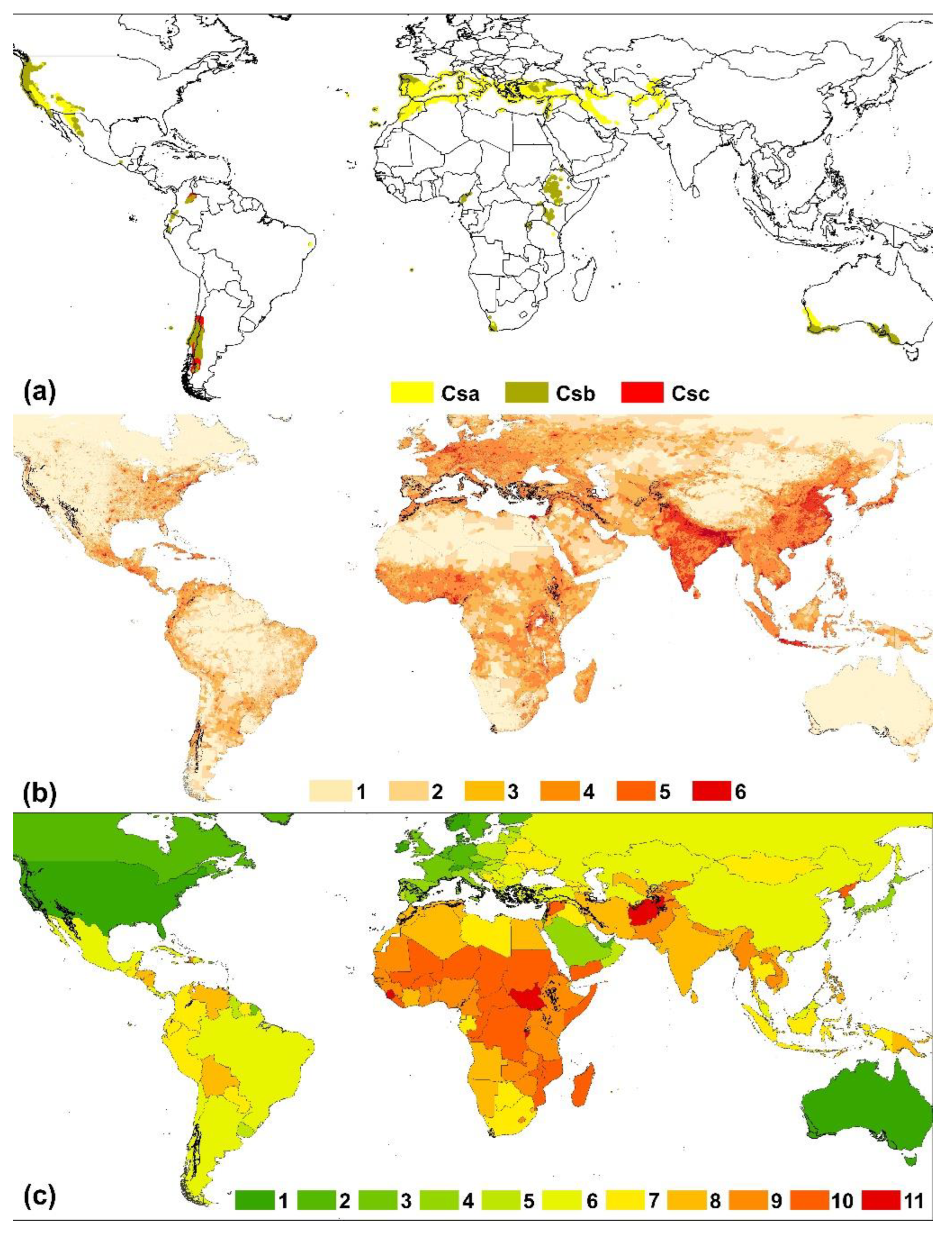
Figure 1. (a) Geographic areas with Mediterranean climate at a global scale. Köppen climate classification: Csa: Temperate, dry summer, hot summer; Csb: Temperate, dry summer, warm summer; Csc: Temperate, dry summer, cold summer. Data source: https://koeppen-geiger.vu-wien.ac.at/shifts.htm. (b) Human population density. Each grid box is about 1 km x 1 km, color coded to show population size. Lighter areas have fewer people. The red dots among most countries are major cities. Person/km2: (1) <1; (2) 1-5; (3) 5-25; (4) 25-250; (5) 250-1000; (6) 1000 +. In grey Csa, Csb and Csc climatic areas indicated in box (a) data source: https://sedac.ciesin.columbia.edu/mapping/viewer/. (c) World map of countries by GDP per capita (nominal) for 2021: (1) >$60,000; (2) $50,000-60,000; (3) $4 ,000-50,000; (4) $30,000-40,000; (5) $20,000-30,000; (6) $10,000-20,000; (7) $5,000-10,000; (8) $2,500-5,000; (9) $1,000-2,500; (10) $500-1,000; (11) <$500. In grey Csa, Csb and Csc climatic areas as indicated in box (a). Source of data: https://www.imf.org/en/Home and https://ourworldindata.org/grapher/gdp-per-capita-worldbank.
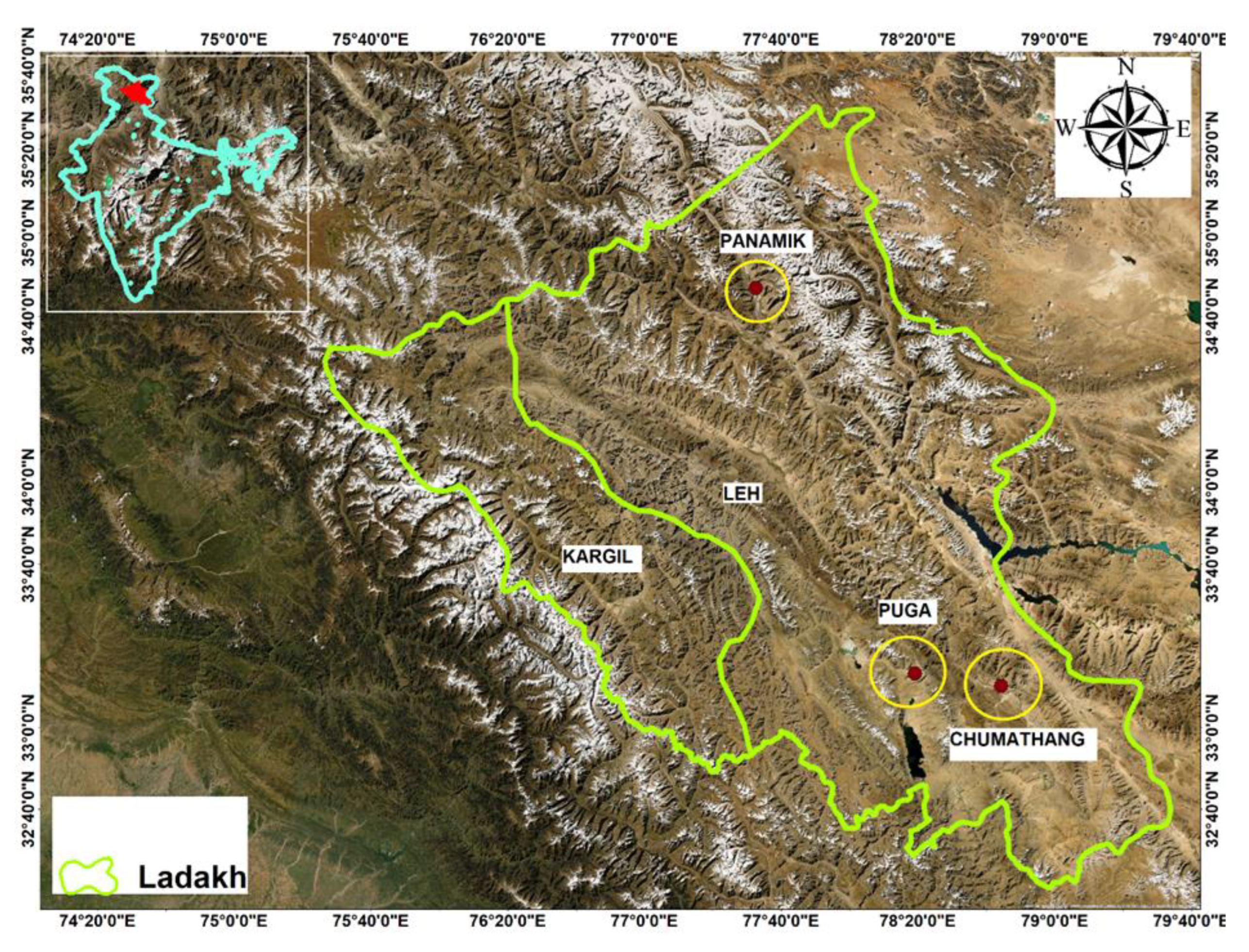
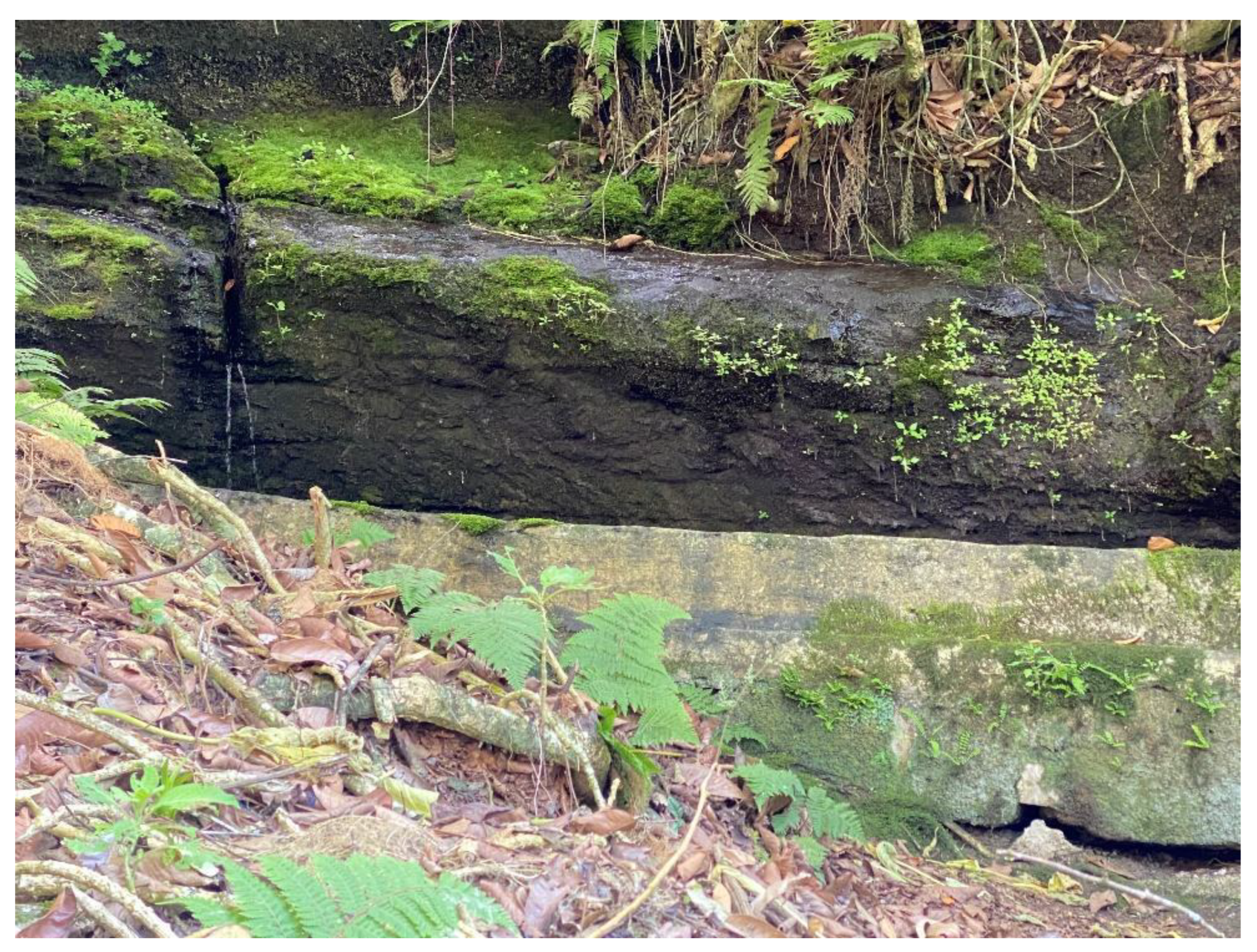
Preprints 96238 g001
Figure 2. Portraits of the key informants, the day they were interviewed.
Preprints 96238 g002
Figure 3. Professions and activities developed by the key informants (n = 13).
Preprints 96238 g003
Figure 4. Location of the reported springs by the key informants on the study area (coloured dots). The colour of each dot is related with the origin of the informant who has reported it. It has not been possible to locate with a minimal precision on the map about fifty reported springs.
Preprints 96238 g004
Figure 5. Number of villages where the key informants have reported the listed uses and activities related to springs (n = 13).
Preprints 96238 g005
Figure 6. Familial meeting at Molí del Vilar Spring (left) and lunch in Sant Salvador Spring. Both pictures were taken in summer 1930.
Preprints 96238 g006
Figure 7. Troughs made of logs (bassis) for watering the flocks in Manyano spring (left) and Clot del Cirer spring (right). Even though the last herds of goats grazing on the mountain disappeared years ago, these two structures have been recently restored by the Natural Park.
Preprints 96238 g007
Figure 8. Wash place next to the Font Vella spring (la Figuera). This was restored in recent times with the repairs of their masonry wash basins and stone scrubbing decks.
Preprints 96238 g008
Figure 9. Number of villages where the key informants have reported the listed causes of spring loss or disappearance (n = 13).
Preprints 96238 g009
Figure 10. Fonts des Tions, spring-flow tunnel located in Artà mountains, east Mallorca.
Preprints 96238 g010
Figure 11. Location of the springs in Mallorca.
Preprints 96238 g011
Figure 12. Es Fontanals spring and its channel (now in ruins).
Preprints 96238 g012
Figure 14. na Simona or Font des Rafalet, a qanat located in Son Servera, east Mallorca, has two flow tunnels: in green the older structures, in red the structures modified or created during 1950’s. The remains of the older tunnel measure 93 meters, with 2 vertical shafts; the new tunnel measures 182 meters and has 14 vertical shafts.
Preprints 96238 g014
Figure 15. Font den Baster. Reproduced from sites.google.com/view/fontsdetramuntana.
Preprints 96238 g015
Figure 16. Font de sa Basseta, spring-flow tunnel located in Banyalbufar in a stepped terrain area. The red arrow indicates its outflow point. Reproduced from sites.google.com/view/fontsdetramuntana.
Preprints 96238 g016
Figure 17. Font de sa Gruta. Reproduced from sites.google.com/view/fontsdetramuntana.
Preprints 96238 g017
Figure 19. Fonte Aretusa (Spring Arethusa) in Syracuse, Sicily (p.c.: J.C.).
Preprints 96238 g019
Figure 20. Karst springs in the Sicó karst massif (central Portugal): A, Alcabideque spring (1, reservoir; 2, Castellum of Alcabideque; 3, community place to wash clothes; 4, picnic area); B, Olhos de Água do Anços spring (1, spring outflows); C and D, Ansião spring (1, spring outflows; 2, urban park); E, Alvorge spring (1, spring outflow; 2, access for vehicles; 3, community place to wash clothes; 4, picnic area); F, Arrifana spring (1, spring outflows; 2, religious symbols; 3, community place to wash clothes; 4, picnic area).
Preprints 96238 g020
Figure 21. A: Aquae Oreginae (Lobios), reproduced from https://galiciapuebloapueblo.blogspot.com/; B: Aquae Querquennae (Baños de Bande). Image: Alexander de los Ríos Conde.
Preprints 96238 g021
Figure 22. Main Roman spas in the Iberian Peninsula. Reproduced from Fundación Séneca: https://fseneca.es/web/elaborado-el-mapa-de-los-balnearios-romanos-de-la-peninsula.
Preprints 96238 g022
Figure 23. Women laundresses in the city of Santiago de Compostela. Reproduced from https://www.parquefluvialdesantiago.org/.
Preprints 96238 g023
Figure 24. Community place to wash clothes associated to springs. A: A Ponte Vella de Vidán spring (Galicia); B: Alvorge spring (Central Portugal); C: Arrifana spring (Central Portugal).
Preprints 96238 g024
Figure 25. Some spring types in Mediterranean Region, Türkiye. A. Rheocrene spring in Acıgöl Lake, Burdur. B. Sulphur spring in Burdur Lake, Burdur. C. Alkaline spring in Muğla. D, Kırkgöz spring in Antalya. E. Alkaline spring in Salda Lake. F. Hotspring spring in Muğla. G. Karstic spring in Muğla (p.c.: C.N. Solak). .
Preprints 96238 g025
Figure 26. (a) Location of cold springs in Cape Town (Harris et al., 2010), and (b) Location of hot springs in the Western Cape Province (Boekstein and Spencer, 2013), South Africa.
Preprints 96238 g026
Figure 27. Location of the Cape Fold Mountains in southwestern South Africa (Source: Wikipedia).
Preprints 96238 g027
Figure 28. Diagrammatic illustration of the generation of The Baths Hot Spring in the Western Cape Province (Source: thebaths.co.za).
Preprints 96238 g028
Figure 29. (a) The Caledon Sanatorium situated on the Caledon hot spring in the Western Cape, photo from 1898 (Source: van Wyk, 2013). (b) Today, the site continues to count on a hotel and spa (Source: southafrica.to).
Preprints 96238 g029
Figure 30. Capetonians collecting spring water during the 2017-2018 Day Zero drought (Source: Baker, 2018).
Preprints 96238 g030
Figure 31. The Wagyl Kaip and Southern Noongar Indigenous Land Use Agreement for Native Title Settlement, in geographical context, showing locations of Wagyl kaip spring and Gnowanyirup spring (p.c.: S.D. Hopper; figure compiled by S.D.Hopper).
Preprints 96238 g031
Figure 32. Moapa crawling water bug, Limnocoris moapensis (Hemiptera: Naucoridae) endemic to a single small springs complex in southern Nevada, USA.
Preprints 96238 g032
Figure 33. South Laja Springs showing multiple gushet emerging from beneath a recent basalt flow from Volcan Antuco (https://www.myguidechile.com/things-to-do/laguna-del-laja-national-park).
Preprints 96238 g033
Figure 34. Termas Geométricas Hot Springs contains >60 springfed pools and waterfalls, with temperatures ranging up to 80 °C. The site was modified into a work of modern structural art designed by architect Germán de Sol Guzmán to facilitate movement through this topographically complex, tectonic landscape (photo: https://ad-c.org/winner/geometric-hot-spring-complex/).
Preprints 96238 g034
Figure 35. Phenes raptor (Odonata: Petaluridae), whose larvae are likely to be springs-dependent in helocrenic wet meadows in Chile. Photo: British Museum of Natural History.
Preprints 96238 g035
Figure 36. Distribution of springs in Kashmir valley by district (Bhat et al., 2023 unpublished).
Preprints 96238 g036
Figure 37. Spring distribution in Kashmir Valley.
Preprints 96238 g037
Figure 38. Examples of springs from the Kashmir Valley.
Preprints 96238 g038
Figure 39. Spring distribution in Tawi basin of Jammu (c.f. S.S. Rawat, 2020).
Preprints 96238 g039
Figure 40. Distribution of hot springs in Ladakh Himalaya.
Preprints 96238 g040
Figure 41. Wittmer Spring on Floreana Island, the only permanent water source on Floreana Island in the Galapagos Archipelago. Photo: L.E. Stevens.
Preprints 96238 g041
Figure 42. A) Number of studies on cultural aspects of springs in Mediterranean climate published between 1994 and 2023. B) Geographic analysis of cultural research on Mediterranean springs, 1994-2023. C) Frequency of mentions of themes listed in keywords among the 126 references found on socio-cultural studies of springs in Mediterranean climates.
Preprints 96238 g042
Figure 43. (A) Word clouds of the titles of papers on the intersection the cultural anthropology of Mediterranean climate springs. (B) Word cloud of key words from papers on socio-cultural anthropology of springs.
Preprints 96238 g043
Figure 44. (a) Cultural values (Cv) commonly associated with springs, few of which are associated with negative costs. (b) Economic values and tradeoffs (Ev) associated with springs exploitation: values above are economically advantageous at least in short-term contexts, while lower variables are costs associated with water management.
Preprints 96238 g044
Table 1. List of informants from the towns of the Serra de Montsant.
Village/hamlet* Informant Age Main profession Number of springs cited**
Albarca Several (11) reported in Palomar (2008) --- --- 20
Cabassers Ramon Masip 69 farmer 23
Cornudella de Montsant Ildefons Gomis 90 farmer 72
Escaladei Benito Porqueres 84 farmer 13
la Bisbal de Falset Miquel Franquet 83 farmer 22
la Figuera Jaume Roca 78 farmer 17
la Morera de Montsant Joaquim Figueres 65 farmer 48
Ramon Sabaté 79 farmer
la Vilella Alta Josep Maria Masip 65 farmer 37
la Vilella Baixa Eduard Juncosa 66 farmer 28
Margalef Miquel Amill 69 farmer 28
Poboleda Salvador Burgos 52 farmer 14
Torroja del Priorat Joan Pàmies 70 farmer & shepherd 59
Ulldemolins Ramon Pere 59 farmer 41
* The springs cited by each informant are not circumscribed exactly to the municipal district, but to the territory best known to the local population, which may include other municipalities and/or exclude part of their own. In the cases of Albarca and Escaladei, it applies to the old districts, which have been integrated into the contemporary municipalities of Cornudella de Montsant and la Morera de Montsant, respectively.
** The number is approximate, since in some cases the number of existing springs in a given area could not be remembered precisely and, on the other hand, some informants only mention the most important ones.
Table 2. Celebratory events in some springs in the Montsant massif.
Spring Date Calendar of saints Village that organizes the event
Santa Llúcia 2nd Sunday in August* --- la Bisbal de Falset
La Foia April 25 Sant Marc Cabassers
August 5 Mare de Déu de les Neus Cabassers
Sant Salvador April 25 Sant Marc Margalef
August 6 Sant Salvador Margalef
August 16 Sant Roc la Bisbal de Falset
* Santa Llúcia (Saint Lucy) is on December 15, a date when it is usually very cold. It is for this reason that the celebration takes place in August.
Disclaimer/Publisher’s Note: The statements, opinions and data contained in all publications are solely those of the individual author(s) and contributor(s) and not of MDPI and/or the editor(s). MDPI and/or the editor(s) disclaim responsibility for any injury to people or property resulting from any ideas, methods, instructions or products referred to in the content.
Copyright: This open access article is published under a Creative Commons CC BY 4.0 license, which permit the free download, distribution, and reuse, provided that the author and preprint are cited in any reuse.
Prerpints.org logo

Preprints.org is a free preprint server supported by MDPI in Basel, Switzerland.

Subscribe

© 2024 MDPI (Basel, Switzerland) unless otherwise stated