1. Introduction
Ecosystems In 2022 soil and archaeological studies were conducted at eight settlements of different ages in the Abzelilovsky district of the Bashkortostan Republic near the Southern Urals mountains. The region located on the border of Europe and Asia and has always served as a as the most important crossroads between East and West, North and South. Its territory with a variety of landscapes, abundance of rivers and lakes, and wealth of mineral resources has attracted people since the Early Paleolithic. World-famous archaeological sites such as the Shulgantash (Kapova) cave with Paleolithic paintings and site of ancient people and Mysovaya Paleolithic site was one of the first to be discovered in the region [
1]; large copper mines – Bakr-Uzyak and Kargaly, developed in the Neolithic and Bronze Ages [
2]; Filippovka 1 – an elite necropolis of nomads of 2500 BP, where 3000 objects were found, including beautiful works of art made of precious metals [
3,
4]; the Ufa II settlements with a cultural layer of 4 m of thickness, which functioned from the first centuries AD [
5]. Archaeologists investigated hundreds of region monuments of different Holocene chrono-sequence [
6]. But only part of them was examined by the methods of natural sciences [
7,
8,
9,
10,
11,
12,
13,
14,
15,
16,
17,
18,
19].
The aim of a complex study of the cultural layers of settlements was to determine, pedological, microbiological and geochemical properties of these layers in order to characterize the natural components in which the population of different cultures had functioned and to obtain more detailed information.
1.1. Reconstruction of the Holocene climate based on the results of paleosols studies
In the steppe Trans-Urals in the Arkaim reserve (south of the modern Chelyabinsk region) 7 alluvial paleosols of the Holocene were studied with 15 radiocarbon datas. Based on the soil properties dynamics and palynological analysis, the followings were found: 200–2000 years ago the Little Ice Age and arid warm “Viking time-period" are noted, 2000–4200 years ago sharp fluctuations in atmospheric moisture, predominance of aridity, increasing continental climate are reflected; 4200–5500 BP – humid, warm, maximum forest areas – 67%; 5500–8000 BP – arid, warm, forests accounted for 15–20%; 8000–9500 BP– Mucky Gley soils reflect sharp fluctuations in climate [
20].
In the steppe Southern Cis-Urals in the period of 6800–5200 BP, the climate was arid, Chernozems Calcic and Chestnut soils developed under mixed grass and gramineous steppes with elements of arid flora. The maximum aridity was in the period of 5900–5400 BP. Later, up to 4200 BP the humidification of climate took place, with the most pronounced humidity 4600–4200 BP. The soils were transformed into Chernozems Haplic, formed under typical mixed grass and gramineous true steppes. It was confirmed by pedogenic and phytolytic methods of studying the cultural layers of different dates in the Turganik settlement and 20 paleosols from several necropolises [
21,
22].
The study of the chronosequences of paleosols dated II thousand BC–1 thousand AD of the Southern Urals revealed humidification in the Middle Bronze Age, and the change of the arid climate to a wetter one during the Early Iron Age [
23].
1.2. Reconstruction of the Holocene climate based on the palynological results
The first scheme of the landscapes and climate transformation in the Holocene was made on the basis of palynological analysis of rivers and swamps sediments in the Western Siberia [
24]. Then, extensive palynological spectra were obtained for the Tobol-Ishim region with 150 radiocarbon dates. It is shown that in the Boreal period 9000–7700 BP the conditions were wetter and warmer than the modern ones. In the Atlantic period 7700–5000 BP, the climate was warmer than the nowadays, during the most part of the period there was a decrease in humidity; an ¬increase in humidity was recorded 6300–6100 BP. In the Subboreal period 5000–4500 BP, it was getting colder, wetness was similar to the modern one, in the period 4500–3200 BP the climate was warm and the most arid, especially 3400–3200 BP, with stages of humidification 4300–4100 and 3700–3450 BP. It was getting colder during the periods 3100–2800 and 2700–2500 BP, and between them there was a warming phase with humidity below modern one. In the interval 2600–2500 BP the warm remained and humidity increased in the region. In the phase 2300–2100 BP, the climate was getting warmer and more arid. In the period 2100–1900 BP, it was getting colder again and humidification of the climate was noted. Throughout the region the trend of shifting of the natural zones boundaries to the south was recorded. In the period 1900–1700 BP, the climate was quite arid, especially near the Ishim River. The cardinal change of landscapes as a result of the humid and cool climate occurred 1700–1400 BP. A little climatic optimum was manifested in a deficit of humidification in the period of 1400–1100 BP, and in a short-term warming 1100–1000 BP. For last 1000 years, the landscapes hardly differed from modern ones [
25,
26].
In the Southern Urals forest-steppe, based on palynological spectra of ten settlements of the Kara-Abyz ethnos, it was found that in the middle of the Subboreal and at the boundary between the Subboreal and Subatlantic, the climate was warm and humid; between them changed to arid one; in the beginning of the Subatlantic humidification decreased, in the middle – the climate became humid, first it got colder, and later warmer; in the Subatlantic end the climate became more arid and colder. Coniferous, broad-leaved, and small-leaved forests spread in the north of the region, steppes and forest-steppes spread in the south, the ratio between biomes changed in accordance with the climate [
27].
The climate reconstruction of the Holocene of the Southern Urals was also carried out on the basis of complex studies of more than a hundred dated objects [
28,
29], some mires peats [
9,
30,
31,
32], several lakes deposits [
33].
Above-mentioned in-text citations have provided information about the climate during the periods of our settlements development. It was shown that in the period 6300–5000 BP (Sabakty-1а site) conditions were drier and warmer than the modern ones, in the phase 6300–6100 BP climate was moist, warm; in the period 3900–3450 BP (Amangildino, Telyashevo-4) the climate was warm and humid, in the stage 2700–2500 BP (Elimbetovo-7) the climate was chilly and moist.
2. Study Area
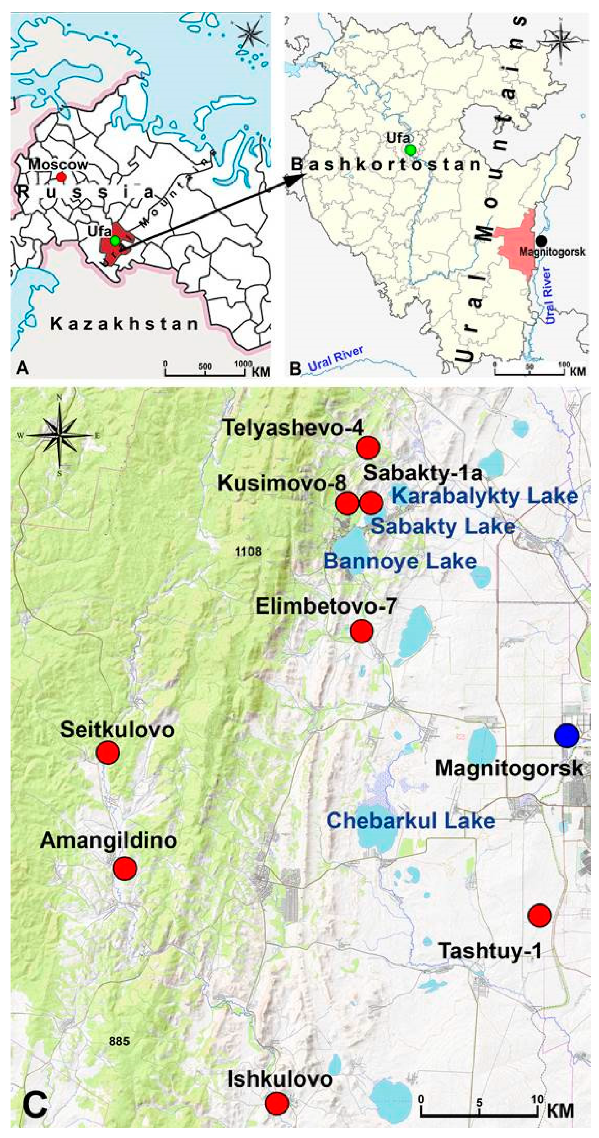
Soil and archaeological studies of eight settlements of different ages in the Abzelilovsky district of the Republic of Bashkortostan near the Southern Trans-Urals mountains, Russia were conducted (
Table 1,
Figure 1). The dates of those settlements range from the to Late Medieval Ages and New Time. The sites are located mainly on the terraces of small rivers of the Ural River basin, are used as pastures with moderate grazing. The altitude above sea level is 400–600 m. The region is located in the mountain-steppe, mountain-forest-steppe and steppe zones of the Southern Trans-Urals. Region is composed of devonian rocks, with quaternary alluvial deposits overlying them in some places. In the foothill part, volcanogenic rocks are represented, in particular, diabase rocks. Forests occupy half of its area. Pine and birch-larch forests and virgin mixed grass associations are widespread, mostly plowed. The average region annual air temperature is 1.4°C, average temperature is +17.6°C in July, -15.5°C – in January. Lowland areas receive 350–400 mm of precipitation per year, mountainous areas receive 550 mm [
34,
35]. In the region large metallurgical and processing enterprises are located in Uchaly and Magnitogorsk, 4–60 km from the studyed objects.
The sites contain material from archaeological cultures of different dates, lie at different depths and have different capacities. CLs developed mainly on Сhernozems, Luvic – frequently, Haplic – less common (Tashtui-1 site), Mollic Leptosol Eutric – on diabase (Amangildino site) and Meadow soil at Ishkulovo site. In all the studied CLs, pottery fragments were mainly found and in Elimbetovo, Kusimovo-8 and Sabakty-1a – stone tools.
Amangildino is a long–term settlement of the Late Bronze Age (Alakul culture 3900–3450 BP), the dating is given as described in [
36]. It is located between the slope of the mountain and a swampy forested valley 65 m from the Bolshaya Nayazda River, and is used as a hay field, previously – arable land. In 2022, only the material of the Alakul culture was found. It is represented by 6 fragments of vessels and 5 animal bones, 24 broken pieces of ceramics and flint flakes were found at a depth of 3–46 cm, mostly in the layer 3–36 cm.
A1 0–25 cm, is a former arable layer, dark gray, medium loam material
AB 25–60 cm is a very dense humus loam with fragments of brown material. The soil-forming
C below 60 cm – a dense light brown material.
Elimbetovo-7 site locates 190 m from the Yangelka River, where the Gamayun culture members lived. 16 ceramic fragments and 15 stone tools were found at a depth of 11–38 cm, therefore, Elimbetovo-7 can be considered a settlement with a large complex of the flint industry. It was called a site 70 years ago after the discovery of a large flint tool. This CL is characterized by a shortened profile – 40 cm, because deeper down a monolithic stone layer of diabase lies.
A1 0–40 cm dark gray loose structured material with fragmental pieces of diabase and separate lenses 5–7 cm thick in light gray and light brown color – 35–40 cm
C – below 40 cm is a stone layer of fragmental diabase.
Ishkulovo settlement was studied in a section that was made in the outcrop of the bank of the Bolshoy Kizil River. At a depth of about 80 cm, a burning lens with coals was revealed, marking the CL beginning. During the initial inspection, it was determined as a nomads site of the XIII-XV cс. AD.
A1 0–30 cm brownish gray sandy loam with grain structure with plant roots
A1 35–50 cm brownish gray fine-grained heavy сlay-loam material
AB 50–80 cm homogeneous gray-brown clay material
80–82 cm dark grey burning narrow strip with coals
B 80–120 cm layered material with sand and clay
Cg 120–140 cm – a blue-grey heavy loam and red layers, pieces of marsh ore and ferruginized stems of marsh plants.
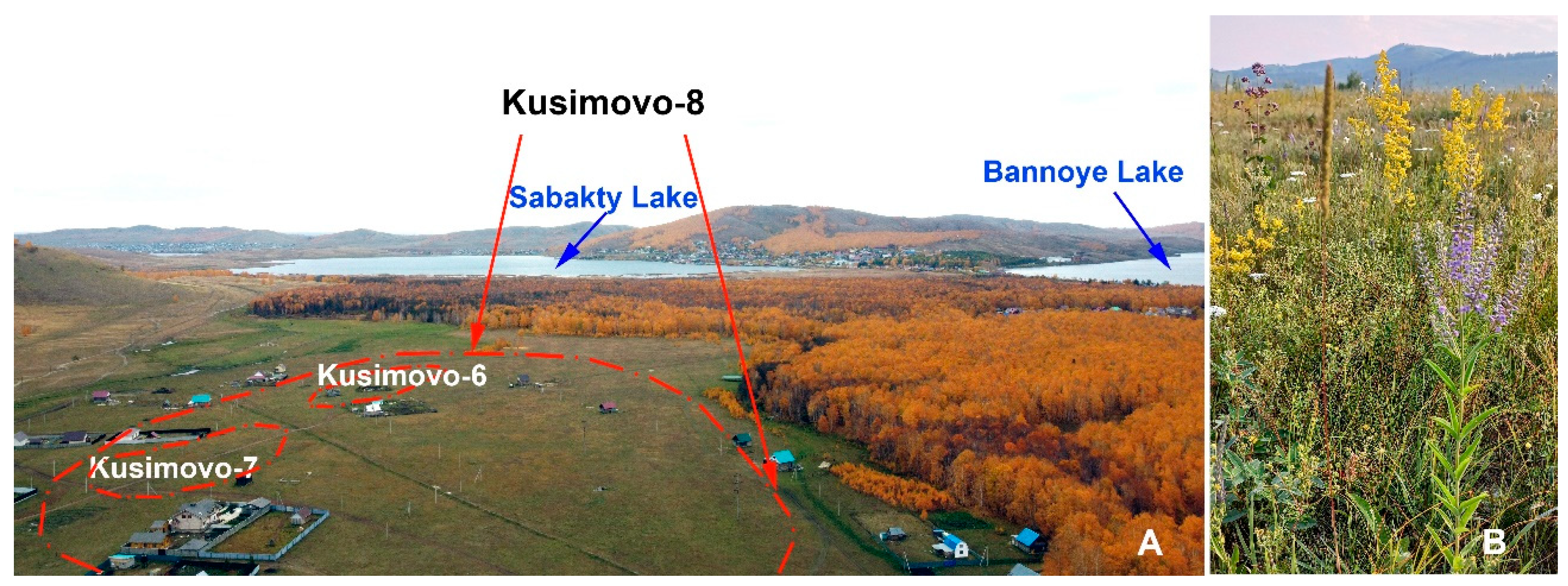
Kusimovo-8 Workshop site functioned at the Lower Paleolithic time. It is located 20 m of Karamala Creek and 1.2 km from the Sabakty Lake. It has been a former arable land up to 2005, now – exploited pasture with a large set of forbs (
Figure 2). The monument area is 175,000 m
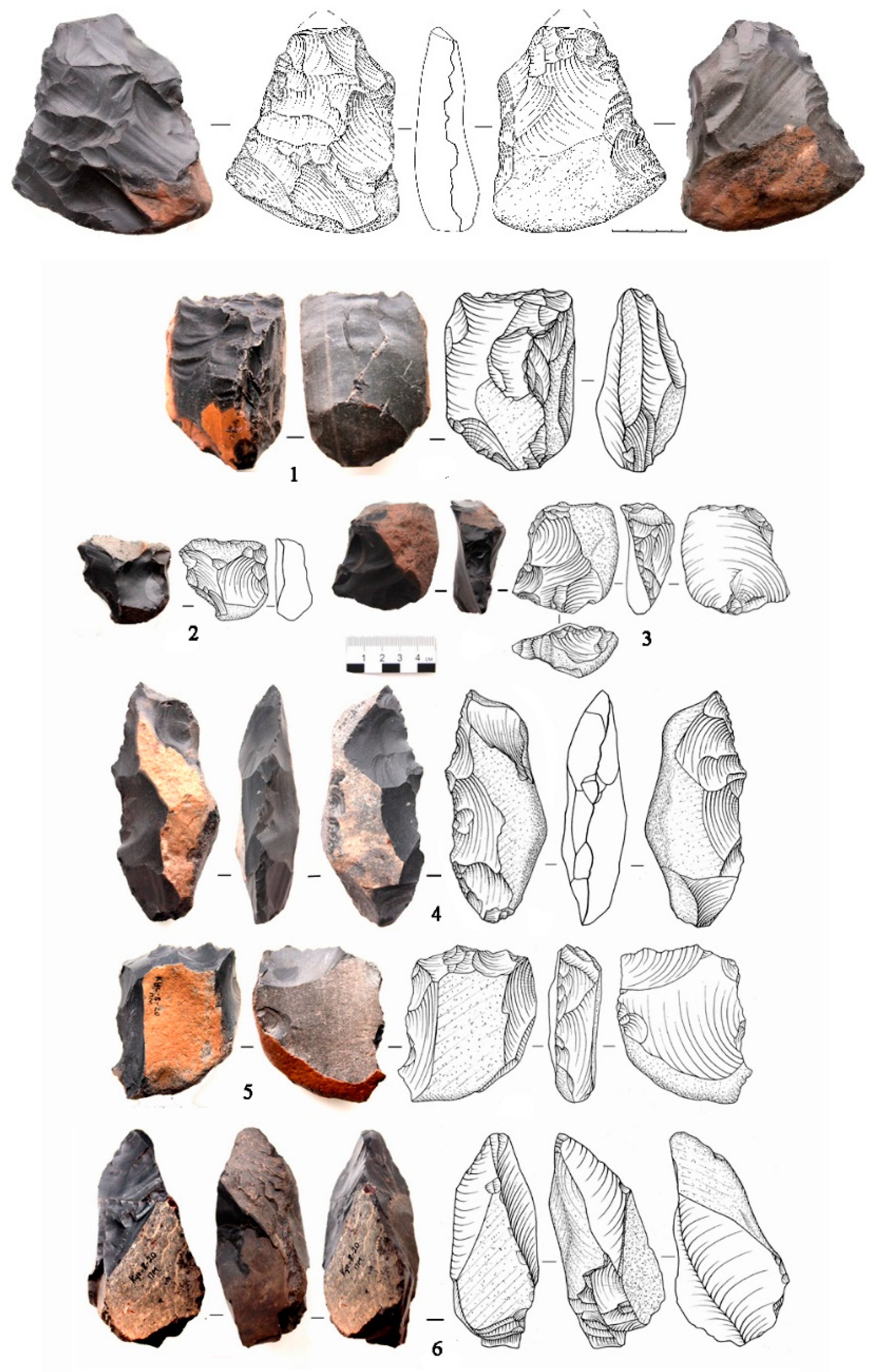
2. During the entire study of the object 4 sections were examined, 121 stone items were found. In 2022 15 stone tools were found in a layer of 25-63 cm. Markers of this are various chopping stone tools – axes, pikes, choppers, cleavers. (
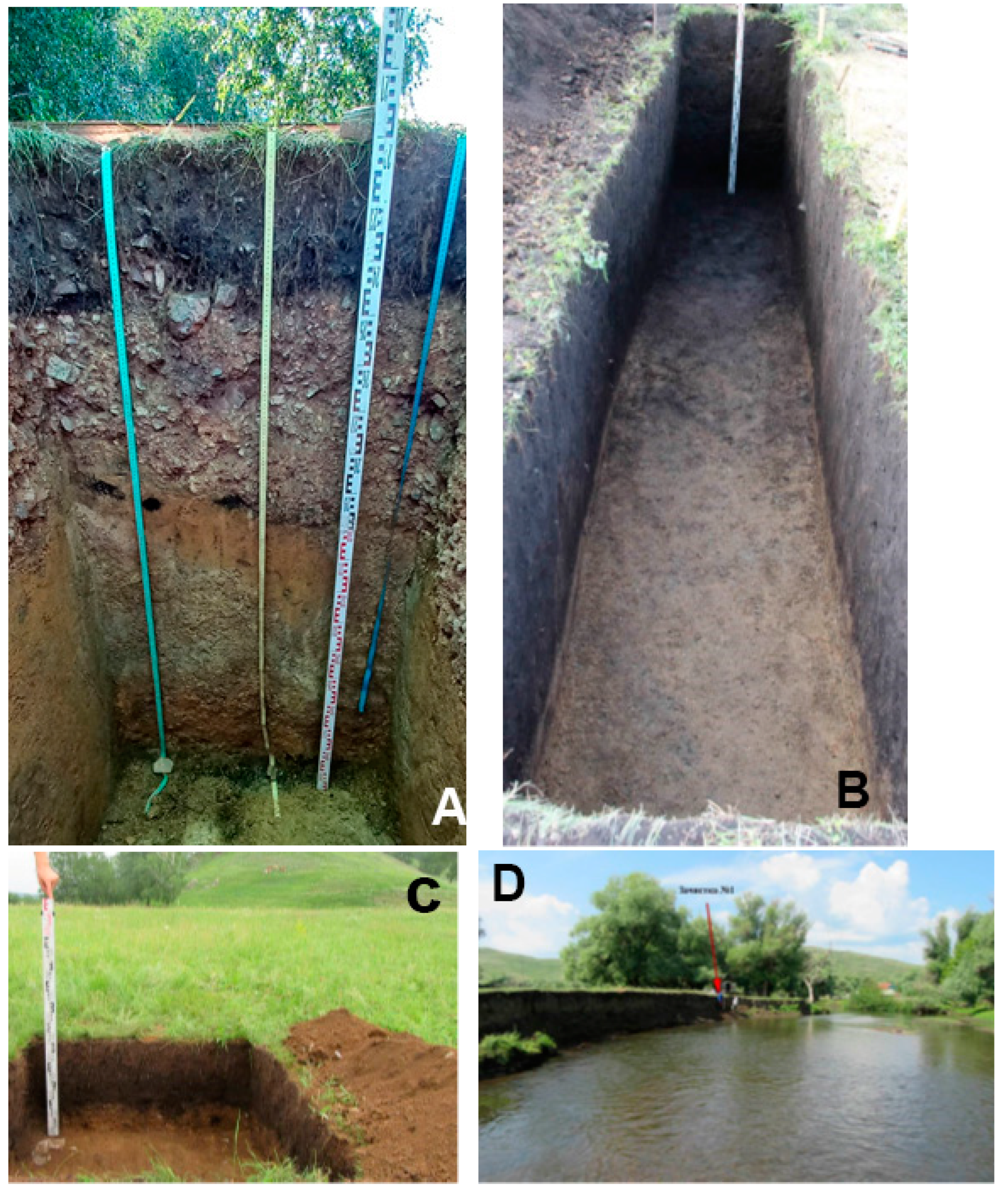
Figure 3). Two cultural layers were discovered at a depth of 0.4–0.8 m and 0.8–2 m (
Figure 4, A) [
37]. Two dates were obtained for the site deposits using the optically stimulated luminescence (OSL) method. In a sample from a depth of 1.8 m, dating revealed an age of 136 ± 9 ka (RGI-1104, VSEGEI), at a depth of 1 m – 258±13 ka (RGI-1103, VSEGEI), obviously the last date is overestimated. Groundwaters lies at a depth of 170 cm, there is sandy loam up to 1 m and then medium textured loam.
A1 0–27(30) cm dark gray, well structured, with a large number of roots and big stones
AB 27(30)–70 cm light brown dense loam, dominated by large pebbles, a layer of light gray material was found at a depth of 60 cm
Cg 70–100 cm brown material with olive tinge from the processes of gleying, three mole holes filled with black material were found
Dg 100–180 cm – olive gley clay layer with some sections of red-brown material.
Sabakty-1a –the Neolithic site-workshop of the Surtandy culture, locates near of the same name lake in a hollow bounded by rocky slopes and a longshore bar, is used as a pasture. In a section with a length of 6 m, 32 stone tools were found in a layer of 18–162 cm, mostly in a layers of 39–45 cm – 5 pieces and 94–128 cm – 10 pieces. Maybe, some these finds can be moved from higher locations belonging to the sites of Sabakty-1 and Sabakty-8 [
38].
A1 0–50 cm dark gray, well-structured, sandy loam friable horizon with stones
A1 50–100 cm dark gray loamy material with small sections of brown dark color
B 100–125 cm brown loam with separate lenses of gray material
[A1] 125–133 cm paleosol of dark gray color. D 135 cm boulder layer.
Seitkulovo settlement locates on the Bolshoy Kizil River terrace. This grassland serves as a hayfield. A character of 10 artifacts collected from the surface and 5 finds in the 3–13 cm layer indicates that the site was a settlement three times in the epochs: Mesolithic, Bronze and Late Medieval Ages or New Times. Also 8 animal bones taken from the surface and 5 ones in the 3–13 cm layer were found.
A1 0–30 cm dark gray finely lumpy friable loamy material
BC 35 cm light brown loam with inclusion of whitish, non-carbonate material
Tashtui-1 settlement localizes on the sloping top of a large steppe syrt near a dried-up lake. 25 finds each were found on the surface and in a layer of 3–20 cm. Two parts of CL are distinguished: the upper 3–20 cm is marked as a fairly long–term settlement of the 2nd half of the XIX century–the beginning of the XX century, and the lower part is a short–term nomads camp of the late Sarmatian period (II-III cc AD), according one ceramic find at a depth of 53 cm. Among all the sites it lies closer to the industrial center of Magnitogorsk – 3.5 km away. The soil profile was dug in a nonarable area.
A1 0–27 cm dark gray, with some pebbles
AB 27–70 cm gray solid material with lighter mole passages and bands
70–135 cm light brown clay penetrated with mole passages
105–135 cm light brown solid parent material.
Telyashevo-4 is a long-term settlement of the Alakul culture (3900–3450 BP), locates on the former arable land of the low terrace of the Analyk River. 14 finds were discovered in a sandy loam cultural layer at a depth of 11–46 cm (mostly in 22–38 cm).
A1 0–27 cm dark gray, with separate pebbles
AB 27–47 cm gravelly dark brown
BC 47 cm dark brown with quite large amounts of pebbles.
3. Methods
In each site with a cultural layer, a deep section was studied, and samples were taken for general soil analyses, and two pits were dug to a depth of 30 cm for microbiological, Corg and geochemical analyses. A morphological description of these sec tions was done. Samples of eight sections were taken from successive layers with a thick ness of 0–10 cm to the parent material, in some site’s samples were taken every 5 cm.
Physicochemical, geochemical and microbiological analyses of soils were performed.
Soil properties were done by follows methods: an elemental analyzer CHNSO for determining Corg and total nitrogen, potentiometry for measuring pH in aqueous solution, the amount of soil exchangeable Ca
2+ and Mg2+ was done according to Shollenberger, the content of mobile P
2O
5 was evaluated by the photometric method, analysis of granulometric composition was carried out by the pipette method with sodium pyrophosphate treatment [
39]. Laboratory analyses were performed at the Common Use Center of the Institute of Physicochemical and Biological Problems in Soil Science of the RAS under the supervision of S.N. Udal’tsov.
For microbiological analyses, the soil with field humidity was sifted through a 2 mm sieve and roots were removed. A 10 g sample in triplicate was moistened to 70-75% of the maximum field moisture capacity, incubated for 7 days at 22°C in 100 ml vials. The vials were then closed, placed in a thermostat at 22°C, basal soil respiration (SR) was determined on a gas chromatograph after 2 days and again after the next 2 days, then the value of microbial biomass (Cmic) was found in the same samples using the substrate induced respiration (SIR) method with 10 mg of glucose addition per 1 g of soil. The SR rate was expressed C-CO2 µg/g of soil per hour. The formula was used: C mic= 40.04 × V SIR + 0.37, (µg C /g of soil, V – rate of SIR) [
40].
Determination of the soil macro- and microelements was conducted on the X-ray fluorescence spectrometer Spectroscan MAХ-GV at Belgorod University (M.K. Buiya, an engineer). The soil elements amount was compared with the region [
41] and clarkes of lithosphere. Clarkes values give according to recommendations [
42].
4. Results:
4.1. Chemical and microbiological properties
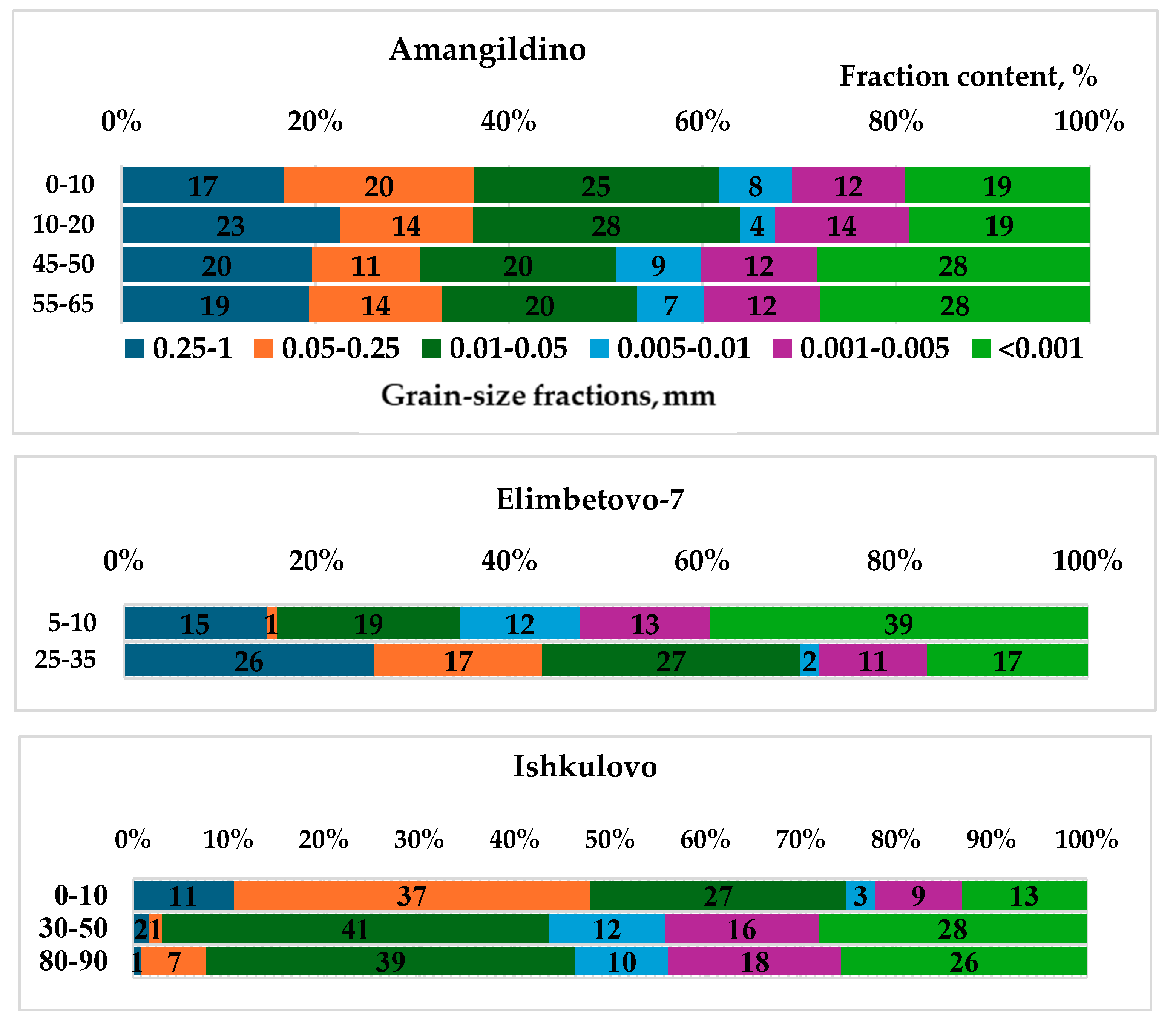
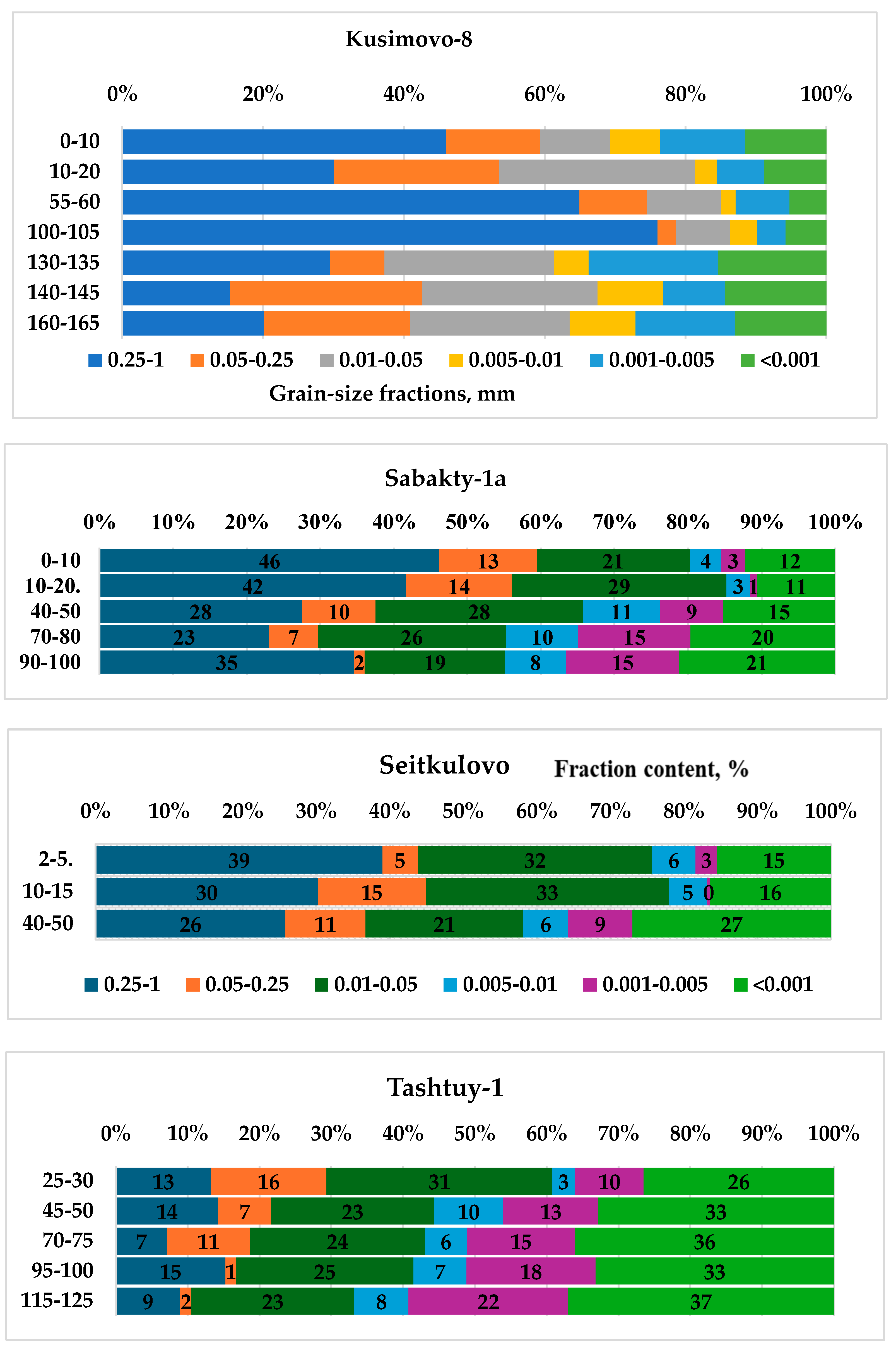
The most CLs have medium and heavy loamy granulometric composition and contain fractions with a diameter of <0.01 mm (38–56%) and sandy fractions of 1–0.25 mm (less than 20%) (
Figure 5, 5a). At Kusimovo-8, Sabakty-1a and Seytkulovo sites the top part of profile is sandy loam with fractions of <0.01 mm (14–20%) and the lower part of the profile is medium loamy (32–45%). In the CLs profile, a pH value close to neutral was mainly detected; only in the Tashtui-1 settlement an alkaline reaction from 30 cm was observed. Soil and CL profiles are not salinized, the amount of easily soluble salts is less than 0.1%. The exchange complex is saturated with calcium up to 74–96% of the total amount of the absorbed cations. easily soluble salts is less than 0.1%.
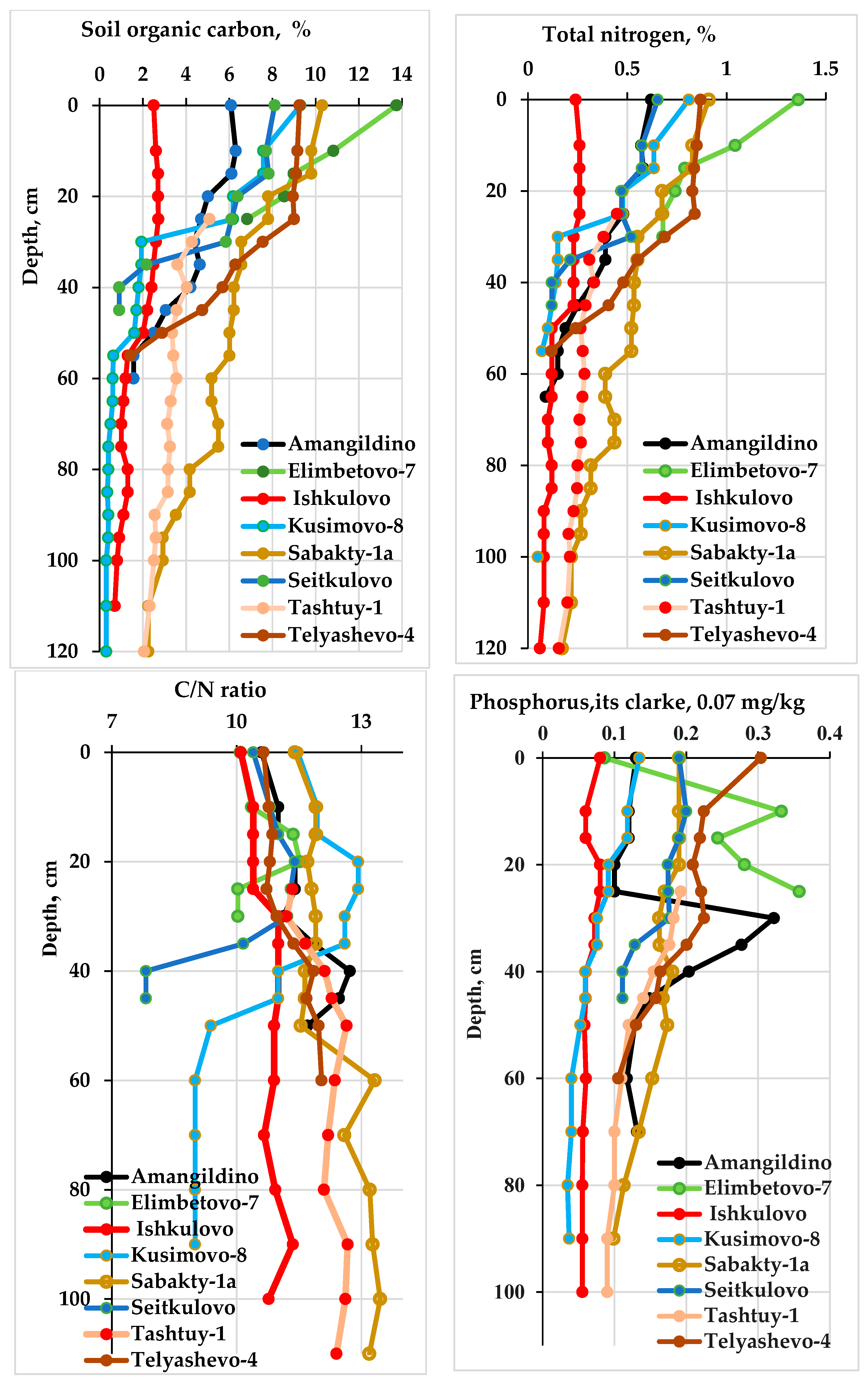
High saturation with organic carbon (Corg) is observed (
Figure 6). The Corg content of the 0–20 cm layer, where the majority of cultural layers starts, is 6–10%, with the exception of Ishkulovo site – 1.3%, since the cultural layer is below 80 cm. Corg at a depth of 40–50 cm – 0.9–3.8%; 90–100 cm – 0.4–3.6%. Maximal accumulation of Corg was in the Sabakty-1a site due to humus transport along the slope, as it locates in a hollow. In the 0–10 cm layer, the content of total nitrogen varies 0.45–1.1% and the C/N ratio is optimal – 10.3–11.5, in Ishkulovo site the content of N is 0.12%, the C/N ratio is 10.9.
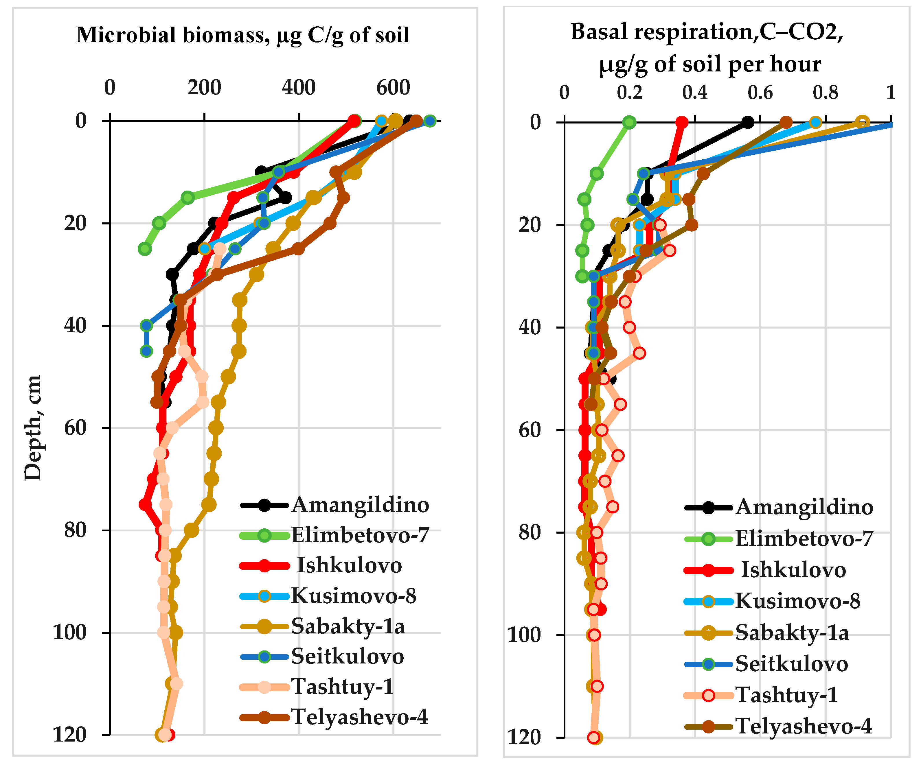
Microbial biomass content (
Cmic) of 0–10 cm CLs is high 520–680 µg C/g of soil, microbes cause emission of 0.2–1 C-CO2 µg/g of soil per hour, in Ishkulovo site – 110 µg C/g of soil and 0.08 C-CO2 µg/g of soil per h, respectively (
Figure 7). In the 10–20 cm CL, the value of C mic is still high, 262–480 μg C/g, and it decreases significantly at a depth of 40–50 cm – 80–160 μg C/g. The Cmic : Corg ratio was estimated and varies from 0.4 to 1.6 in the 0–10 cm layer of the studied CLs. In Ishkulovo site, the CL begins below 80 cm and at a depth of 80–90 cm the Cmic : Corg ratio is 0.9. In the Ishkulovo object, in a 0–10 cm layer of modern soil, organic carbon is most enriched with carbon of microbial origin, despite the minimum content of Corg, C mic and Ntot among the studied CLs, the C/N ratio is optimal and the content of available phosphorus is high, which probably determines the high C mic : С org value despite the minimum content of Corg, Cmic, Ntot and C/N ratio among the studied CLs is optimal and the content of available phosphorus is high, which determines the high value of Cmic : Corg.
4.2. Geochemical properties
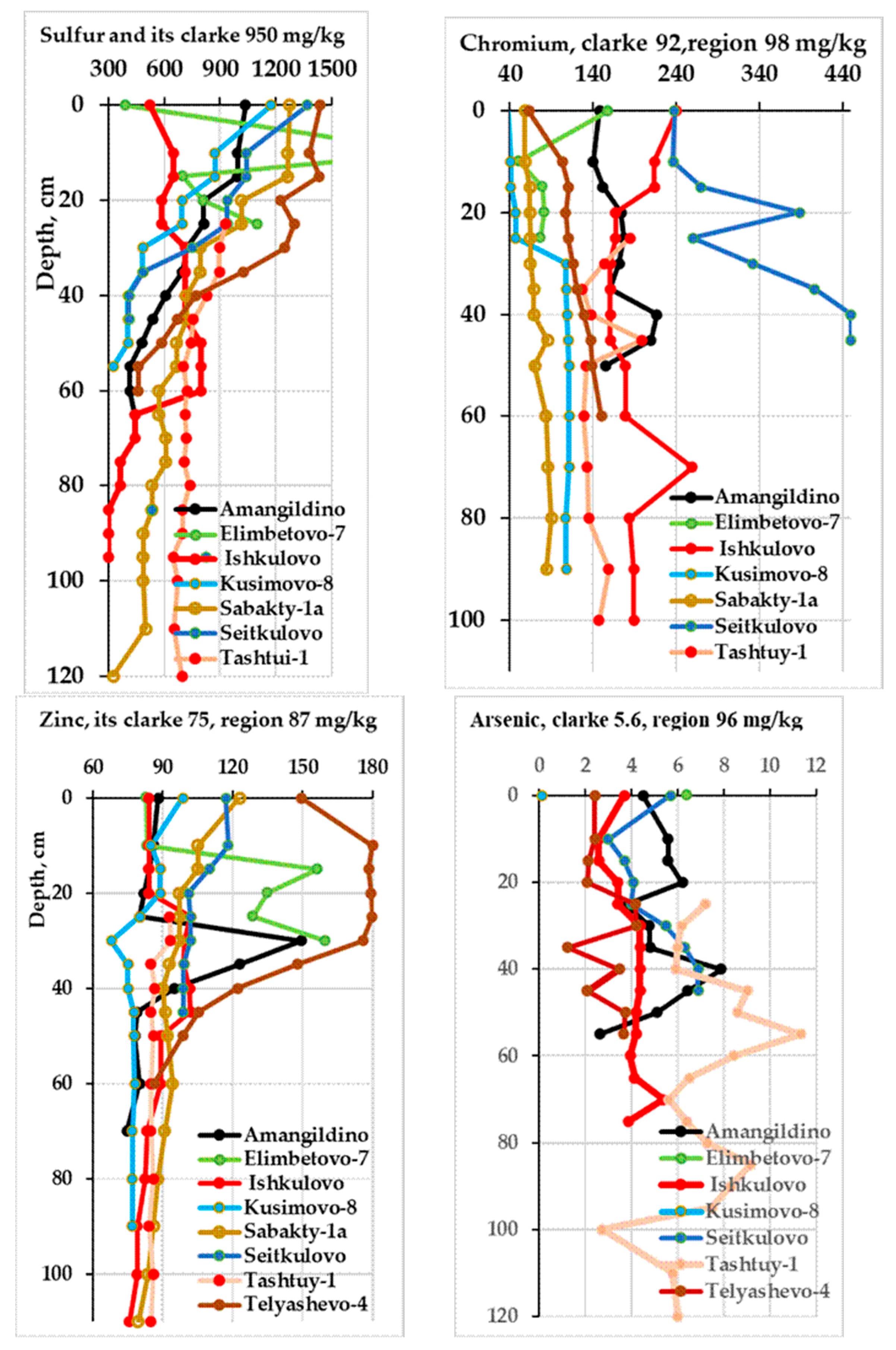
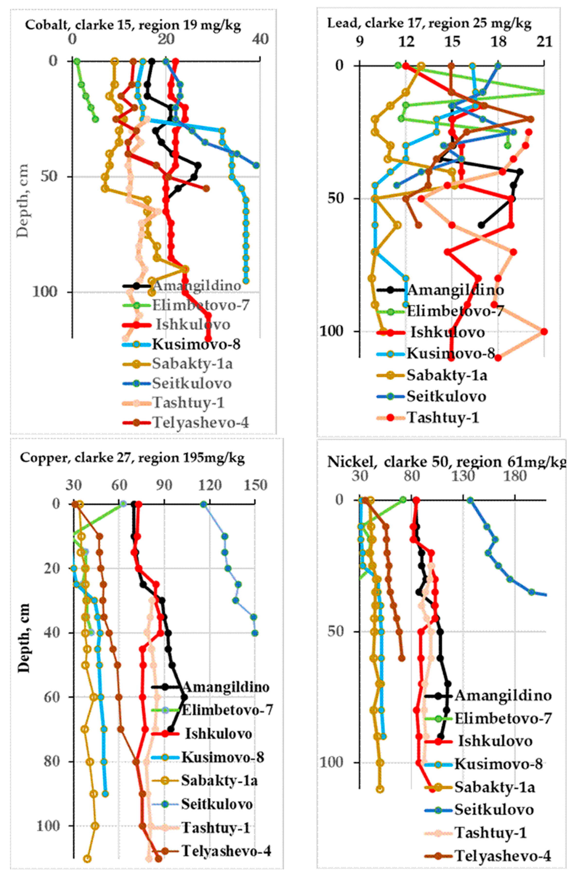
Amangildino is a long-term settlement of the Late Bronze Age (Alakul culture 3900–3450 BP), cultural layer thickness was 3–46 cm. A small concentration of sulphur in this CL is observed in 0–10 cm layer above the clarke (
Figure 8, 8a). The biogenic phosphorus content at a depth of 30–45 cm is 0.20–0.36%, in parent material – 0.12%. In the same layer, the concentration of highly toxic zinc is found to be 1.2–2 times greater than the clarke and parent material. Arsenic is an element (toxicity category I) in quantities higher than the clarke and soil-forming material was found in the 10–20, 20–30 and 45–50 cm layers. In the whole profile, excess clarke was determined, the content of copper, chrome, nickel and manganese was 2–3 times greater than the clarke.
Elimbetovo-7 settlement of the Gamayun culture is dated back to 2600-2500 BP. In its cultural layer, the maximum biogenic phosphorus saturation are observed among all studied objects – 0.24–0.36% at the 10–35 cm depth. In the same depth, the content of zinc is 1.7–2.1 times greater than the clarke. A plethora of sulphur is locally distributed in the 10–15 cm and 25–35 cm layers and its content is 2.1 and 1.2 times, respectively, greater than the clarke. Significant concentrations of copper, cobalt, nickel, chrome, and vanadium were determined in the 5–10 cm layer, and their contents were 1.4–2.3 times higher than the clarke. The largest amounts of rubidium and zircon are also distributed at a 5–10 cm depth in contrast to that observed in other layers, but their contents are not higher than the clarke. The increased calcium content is found in all layers but except 5–10 cm layer, this is due to a specific chemical composition of diabase.
Ishkulovo settlement, nomads, XIII-XV cс. AD, CL lies below 80 cm. There is no anthropogenic phosphorus accumulation in the whole CL and soil profile above it. In the whole profile of the CL and modern soils, an increased amount of copper, nickel and chrome – the elements of the 2nd hazard class is observed, it is 2–3 times higher than the clarke. In the soil horizons above CL, the content of sulfur is higher than that in the deeper layers, but it does notexceed the clarke. It was revealed that manganese deposition occurs at 0–50 cm depth; its content is 1.4–1.8 times higher than the clarke and in the parent material. CL is not enriched in other elements.
Kusimovo-8 is Lower Paleolithic time Workshop site. Biogenic accumulation of phosphorus detected at 0–20 cm depth in the amount of 0.08–0.13% is larger than that observed in the deeper layers. Small concentration of zinc and sulfur was found in the 0–20 cm layer, their content is 1.2 time greater than the clarke. It is recorded a significant concentration of copper, cobalt, and chromium in 30–60 and 100–105 cm layer, 1.2–2.3 times higher than in the lower layers and above the clarke. Nickel and strontium are also accumulated in these layers as compared to those the soil-forming rock, but their amount does not exceed a clarke.
Sabakty-1a is Eneolithic settlement of the Surtandin culture, CL lies at 18–162 cm depth. Phosphorus distribution is uniform, accounting for 0.2% in the 0–80 cm layer and 0.1% below 100 cm. Sulfur concentration found in the 0–30 cm layer is higher than that in the deeper layers, and it exceeds the clarke by 1.2–1.4 times. Deposition of zinc, an element of the 1st toxicity category, in the 0–70 cm layer of this CL is observed, and its content is 1.3–1.9 times higher than the clarke and the parent material. Increased amount of copper and manganese is determined over the whole profile; their content is 1.3–1.5 times higher than the clarke, and in the 60–100 cm layer Mn is 1.5 times higher than in the parent material. The other studied elements of this CLs are evenly distributed, and their content is less than the clarke.
In the Seitkulovo settlement the CL covers 0–13 cm. Phosphorus distribution of the 0–35 cm layer is uniform and about 0.2%. Sulphur concentration occurs in the 0–20 cm layer and it is larger than that in the deeper layers and exceeds the clarke by 1.2-1.7 times. Manganese is an element of the 3rd toxicity category, is evenly distributed over the profile and in all the layers it is 1.4–1.6 times higher than the clarke and parent material. Increased amount of copper, nickel and chrome is 3–5 times higher than the clarke in the whole profile and it increases down the profile.
Tashtui-1 settlement, XIX – the beginning of XX century, CL lies at 3–19 cm layer. Samples of the 0–25 cm arable layer were lost, where archaeological finds were found. Biogenic small accumulation of phosphorus in the amount of 0.2% at the 25–55 cm depth was found, sulphur is also deposited at this depth, its abundance is 1.3–1.6 times higher than that in the soil-forming rock, but it does not exceed the clarke. Accumulation of arsenic, an element of the 1st toxicity category, in the 25–65 cm layer has been found to be 1.3–3 times higher than the clarke. The abundance of chrome, copper and nickel, the elements of the 2nd hazard category, is observed in the whole profile. Their content is 1.5–2 times higher than the clarke.
Telyashevo-4 is a long-term settlement of the Alakul culture (3.9–3.45 BP), CL lies in the 11–46 cm layer. Accumulation of biogenic phosphorus in the amount of 0.2–0.3% is detected at the depth of 5–55 cm, its maximum amount is seen at a depth of 10–40 cm in this CL. Sulphur is also a biogenic element, its content found in the 5–35 cm layer is 1.3–1.5 times higher than the clarke of the lithosphere and 2.7–3 times higher than in the parent material. Potassium is accumulated in small amounts in the 10–30 cm layer as compared to the lower layers.
Deposition of zinc and lead, the elements of the 1st class and 2nd toxicity category, was revealed in the Telyashevo-4. Zinc concentration is found to a greater extent in the surface layers and it decreases down the profile, its content is 1.4–2.4 times higher than the lithosphere clarke and 1.7–2.1 times higher than that one in the parent material. Lead accumulation in the CLs is 1.4–2.1 times higher than in the soil-forming material and in two cultural layers its content is higher than the clarke. In the CLs the contents of chrome and nickel, the elements of the 2nd toxicity category, gradually increases down the soil profile and reaches its maximum in the soil-forming material, but everywhere its content is 1.2–1.5 times higher than the clarke and is lower than the clarke in the 5–20 cm layer. It was shown that the content of copper is 1.2–2.2 times higher than the clarke in the whole profile and its amount is minimal in the surface layer. Manganese distribution along the profile is rather uniform and approximately equal to the parent material, only in the 5–10 cm layer its content is 1.7 times higher than in the parent material, but along the whole profile and in the rock the Mn content is 1.5–2.4 times higher than the clarke. In the CLs chrome content is lower than that in the soil-forming material, but it is higher than the clarke in all the layers studied, which can be explained by the peculiarities of the region.
5. Discussion
An interdisciplinary study of soils and cultural layers was carried out for eight settlement sites dating from the Paleolithic to Late Medieval and Modern Ages in the eastern slope of the Southern Urals mountains, on the border between Europe and Asia, Russia.
Ancient settlements belong to different ethnic groups. All finds from Elimbetovo-7 belong to the Gamayun culture, which existed 2900–2400 BP. Its range covered the subtaiga regions of Western Siberia, Middle Trans-Urals and northern part of the Southern Trans-Urals. The Elimbetovo-7 site is the southernmost monument of this culture in the Trans-Ural. The settlements had half-dugouts and large log houses surrounded by defensive log walls and a ditch. The inhabitants were mainly engaged in hunting, partly in fishing and cattle breeding (they raised large and small cattle, horses), they produced ceramics and mainly tools from stones and less – bones and clay. The smelted copper was used to create jewelry [
43].
Amangildino and Telyashevo-4 are long-term settlements of the Alakul culture 3900–3450 BP, dating is given according to [
36]. The monuments of this culture are present in the southern Trans-Urals and Northern Kazakhstan, settlement sites were revealed along the rivers and some in watershed. Economically, this population practiced domestic cattle breeding; hoe farming, hunting, fishing and gathering play a secondary role [
44].
The Sabakty-1a site belongs to the Surtanda culture, which existed in the Eneolithic in the Southern Trans-Urals. Based on 40 radiocarbon dates for Eneolithic sites of the Trans-Urals is shown, that they fit into the period 6300–5000 and 6500–4200 BP calibrated dates with an accuracy of 1σ (68.2%) and 2σ (95.4%), respectively [
45]. Unfortified settlements were located near rivers and lakes. The population lived in half-dugouts and dugouts with fireplaces, the walls were reinforced with stone slabs. Characteristically, there is an abundance of stone tools, ornaments on dishes, and isolated items made of native copper. They were engaged in hunting, fishing and cattle breeding [
46].
The boundary of the CLs studied starts close to the surface (from 3 to 25 cm) and modern soil formation processes occur in them, except for the Ishkulovo site, where the CL is located below 75–80 cm. CLs end in the layer from 40 to 60 cm, in the Eneolithic site Sabakty-1a CLs end at 162 cm depth. Most likely, at the time the cultural layer of these settlements was less thick than at present. This is evidenced by the number of pottery fragments (110 items) from the log frame settlement, which is about 3000 years old. It has been revealed that artefacts were redistributed from the surface to the deeper layers: at the 0–20 cm depth (60%), at the 20–40 cm depth (30%), and at the 40–70 cm depth (10%). This redistribution occurs due to their infilling into cracks, soil fauna activity, gravitational immersion due to thixotropy when the upper layer becomes too wet [
47].
pH value. The whole thickness of the objects studied has a reaction of solutions close to neutral, pH values are almost the same throughout the vertical column. This is favorable for vegetation and biota. Only in the Tashtui-1 site pH 8–8.6 is alkaline, starting from the depth of 30 cm due to enrichment of carbonates. However, the main plant roots and microbes are concentrated mainly in the surface layers where the reaction of solutions is not alkaline.
Cultural layers of the most sites studied have medium and heavy loamy granulometric composition and contain fractions with diameter <0.01 mm (38–56%) and sandy fractions with diameter 1–0.25 mm (about 20%). In the Kusimovo, Sabakty, Seitkulovo sites, the granulometric composition of the upper profile part is sandy loam with <0.01 mm fractions (14-20%), while the lower part is medium loamy and the percentage of <0.01 mm fractions is 32-45%. This indicates that layers are heterogeneous in their lithological aspect and probably have a high retention of water in the upper part of the profile. The studied soil profiles and CLs are desalinized; the content of easily soluble salts is less than 0.1%.
Organic carbon. In the CLs profile, the amount of Corg is characterized by a well-defined accumulative distribution with maximum in the upper part and its slow decline along the profile. This is typical for chernozems [
48]. The CLs studied contain Corg (6–10%) in the 0–20 cm layer. A large amount of Corg in the region soils was noted earlier [
49]. In Ishkulovo CL, Corg decreases up to 1.3%, since 80 cm of the modern soil covers the top of the CL, i.e. there is no input of new organic material and mineralization of the existing organic mater occurs. The 0–20 cm layer of modern soil at Ishkulovo site contains a minimal amount of Corg (2.5%), which is due to strong vegetation cover digression because of cattle grazing and decreased biomass.
In the 0–10 cm layer of the studied CLs, the total nitrogen content varies 0.45–1.1%, C/N ratio is optimal – 10.3–11.5, in Ishkulovo site N – 0.12%, C/N – 10.9.
The abundance of microbial biomass in the 0–10 cm cultural layers is high 520–680 µg C/g soil, microbes cause organic compound emissions 0.2–1 C-CO2 µg/g soil per hour, at Ishkulovo site the abundance of microbial biomass is 110 µg C/g of soil and emissions is 0.08 C-Co2 µg/g soil per hour. In the 10–20 cm CL, the C mic value remains significant (262–480 μg C/g) and decreases considerably at the depth of 40–50 cm (80–160 μg C/g).
The biogenic phosphorus amount of in the CLs studied reaches 0.2–0.4%, in the parent material – 0.1%, clarke – 0.09%. The values greater than 0.1% indicate anthropogenic influence in the formation of the cultural layer. There is no accumulation of phosphorus at the Ishkulovo site. Significant enrichment of CLs with phosphorus and non-carbonate calcium at settlement sites is related to the input of these elements from animal bones containing stable calcium phosphates – apatite. It is poorly soluble and is not carried away by soil solutions. Phosphorus also enters CL from wood, food residues and household waste. The accumulation of phosphorus in CL indicates that way of life was settled, and people stay was long. Phosphorus deposition in CL at the settlements is a distinctive feature [
50,
51,
52]. This is because more than 50% of anthropogenic material enriched with organic compounds that contain phosphorus can be brought into the long-term CLs, as found in sediments from ancient cities in Crimea (Tanais, Fanagoria) [
53].
The potassium increasing are not observed in the studied CLs compared with soil-forming material. The elevated level of potassium occurs only in a thin coal layer at 80–82 cm depth in Ishkulovo settlement. The source of potassium in CL is wood ash, which is accumulated near fire places and in ashy layers. It was documented that in addition to potassium, ash deposits also contain Cu, As, Si, Al and Pb [
54].
The manganese content was also found in 1.3–3.1 times higher than the clarke in the CLs, an exception is the Tashtui-1 site. This can be mainly explained by the fact that the region contains much manganese ore. So, during the war in the 1940s manganese was mined near the ancient settlements Kusimovo-8and Yelimbetovo. At the same time, Mn can get into CLs from ceramics, bronze smelting wastes, ash deposits, ashes of hearths and stoves. Earlier Mn was found in the CL in pottery fragments: 600–700 mg/kg, slag from bronze production – 200-5000 mg/kg, plant ashes – 700–4800 mg/kg. In places where fires occur, the accumulation of manganese can reach up to 6500 mg/kg, especially during burning of trees (alder, willow) grown under wet conditions. Peculiar behavioral reactions could be noted in people who were constantly near the fireplace and inhaled Mn with smoke [
55].
The sulphur accumulation was detected compared to soil-forming material, sometimes it exceeded the clarke value in a series of CLs. Sulphur can enter the CLs with the products of human activity, and as a result of destruction of ceramic fragments and from ore and slags from bronze production. It was described earlier [
56].
Phosphorus and sulphur are the elements of intensive biological accumulation by plants, and Mn – of biological capture [
57]. They are deposited in the upper horizon of soils after plants’ death. It has been shown that at climate drying in steppes the share of wormwood and goosefoot increases and K, Ca, P, S are deposited in soil, while during humidification – graminoid species spread and the content of every element in the soil increases [
58].
The arsenic, an element of the 1st toxicity category, its content is higher than the clarke and the soil-forming material, it is found in the 10–20, 20–30 and 45–50 cm layers of the Amangildino settlement of the Alakul culture (3900–3450 BP). Arsenic was probably accumulated during the stages of some intensification of the activity among the population of this site. An increase in arsenic levels in the soil at the Tashtui-1 site was observed lower the CL at 25–30 and 45–100 cm depth, its content was 1.3–2 times higher than the parent material and the clarke, in the 55–60 cm layer its content (10 mg/kg) even slightly exceeds the permissible value. This is because of natural proximity to the industrial city of Magnitogorsk (3.5 km) and anomaly of the region. Hence, the content of As in soils of the south of Western Siberia is 13 mg/kg [
59], in the mining and ore region of the Urals it is 96 mg/kg, in the northern forest-steppe of the Cis-Ural region it is 20 mg/kg [
41]. These authors believe that the permissible value for arsenic is underestimated; for example, the world’s soils are considered uncontaminated when its content is 1–95 mg/kg [
60].
Among toxic pollutants of the 1st hazard category, Zn accumulation was also found compared to the soil-forming material and clarke in the Amangildino and Telyashevo-4(3900–3450 BP), Sabakty (6300–5000 BP) and multitemporal site Seytkulovo. In these CLs, the zinc amount was higher than its range limits in soils of the Mining Trans-Urals region (Zn 80–95 mg/kg) [
41]; but less than 220 mg/kg – a value that is dangerous for human health [Kloke, 1980, citation to 59].
In the 0–10 cm layer of all CLs and soils studied, anthropogenic contamination with zinc, lead, copper, chrome, manganese, less often arsenic is possible. This occurs because the studied objects are located 4–44 km and the Yelimbetovo-7 – 60 km from Magnitogorsk metallurgical plant, and Kusimovo-8, Sabakty-1а, Yelimbetovo-7 are located near manganese deposits. In the soils of Magnitogorsk, where the plant is located, the maximum allowable concentrations of hazardous chemicals for human health are several times higher: arsenic – 3–21 times; zinc – 2–4 times; lead – 1–5 times; copper – 1.5–2 times; manganese – 1.5–2.5 times [
61].
In some CLs, the content of copper, chrome and nickel, the elements of the 2nd toxicity category, increases gradually down the profile and reach their maximum in the soil-forming material, but everywhere in the profile their content is 1.2–4 times higher than the clarke. Consequently, the reserve of these elements is formed due to geochemical anomaly of the mountain region, where large reserves of copper, chrome and manganese ores are stocked.
It is worthy of note that beginning from the Bronze Age, contamination of CL with many pollutants was found in settlements. Whereas in the Neolithic and Eneolithic CLs, for example, on the territory of Kochegarovo-1 settlement (forest-steppe zone, Kurgan region, the south of Eastern Siberia), these pollutants were not detected, but accumulation of phosphorus, potassium, calcium, magnesium, manganese and strontium was observed. They serve as indicators for reconstruction of economic activity of the ancient population [
62,
63,
64]. Observation of the sources of soil and water contamination with heavy metals and their harmful effects on human health was carried out and biological and chemical methods of soil and water recovery were proposed [
65].
With slag and ore of bronze smelting production, pollutants of hazard class I and II such as As, Pb, Cr, as well as Zn, Mn enter the CL. In addition, As, Cr, Pb and to a lesser extent Zn enrich the CL due to destruction of large amounts of pottery fragments and materials of residential and defense constructions. The composition of ore, slag and ceramics, as it is shown for the CL of the Berezovaya Luka settlement of the Bronze Age, point to the sources of these elements [
56,
66].
6. Conclusions
The factors that contribute to the appearance of ancient settlements in this region were the form of relief – location near the Urals mountains, that can work as defenses and availability of a great number of mineral resources, access to water, fertile soils and the presence of wild animals living in the nearby forests.
With the artefacts found, it is shown that the depth of cultural layers varies from 3–25 cm to 40–50 cm, in the Eneolithic site Sabakty-1a CL is observed up to 162 cm depth, in the Ishkulovo site it appears lower at 80 cm depth. Favorable chemical characteristics of the cultural layers formed in Chernozems and Meadow soil (Ishkulovo) were described. At present, soil development processes continue to develop in CLs.
The structure and properties of CLs are stipulated by pedogenic, chemical and geochemical processes and intensive human activity in relatively small areas. In the studied CLs pH mainly close to neutral, good structure, saturation with exchangeable calcium, absence of salinization were found. There is a high enrichment of organic carbon 6–10% in CLs, 0–20 cm layer, except for Ishkulovo site – 1.3%, as the CL is below 80 cm and mineralization occurs in the absence of fresh organic material input. Corg content of the 40–50 cm layer is 0.9–3.8%; 90–100 cm – 0.4–3.6%. Microbial biomass value of 0–10 cm layer is high 520–680 µg C/g soil; microbes cause emission of 0.2–1.0 C-CO2 µg/g soil per hour. The C mic : Corg ratio varies from 0.4 to 1.0 in the 0–10 cm layer.
Human activity affects the processes of translocation of the elements especially in the surface layer of the settlements. Animals stones were found in the CLs, their destruction and accumulation of organic products of animal and human life activity caused deposition of biogenic forms of phosphorus and calcium.
The proximity of the studied sites to the deposits of copper, chrome, zinc, manganese in Urals mountains and Magnitogorsk Metallurgical and Uchaly mining and processing plants creates geochemical anomalies of the region soil, described earlier in the literature. Anthropogenic factors are superimposed on natural ones – the release of pollutants in the CLs from the bronze products, ore, fragments of ceramics and raw materials. This is the reason for concentration of a number of pollutants of the 1st (arsenic, lead, zinc) and the 2nd (cobalt, copper, nickel, chrome) hazard classes in the studied CLs. These elements are often found in quantities higher than the clarke and in rare cases their levels are beyond the permissible limits that can have negative effects on human health.
Reconstruction of the climate of different Holocene chronosequence on the basis of literature and pedogenic and palynological data obtained in our study showed that during the periods when the studied settlements delivered everything people need to live their lives, the climate was favorable to human habitation. This, along with good soil properties, contributed to the development of forests and meadow-steppe vegetation and the existence of productive pastures.
Above-mentioned in-text citations have provided information about the climate during the periods of our settlements development. It was shown that in the period 6300–5000 BP (Sabakty-1а) conditions were drier and warmer than the modern ones, in the phase 6300–6100 BP climate was moist, warm; in the period 3900–3450 BP (Amangildino, Telyashevo-4) the climate was warm and humid, in the stage 2700–2500 BP (Elimbetovo-7) the climate was chilly and moist.
Author Contributions
V.E., N.S., V.G., S.Yu., E.V. and M.M. performed the fieldwork and soil sampling; N.S., S.Yu., V.G., E.V. and M.M. organized the field work excavation and provided all the archaeological information; V.E. performed microbiological analysis; V.E., N.S., V.G., S.Yu., wrote the paper; and all together we discussed the obtained data and corrected the text.
Funding
This research was funded by of state contract “Soil development under conditions of changing climate and anthropogenic influences” no. 0191-2019-0046, RFBR 20-05-00482 Reconstruction of climate, landscapes and soils of the Holocene on the basis of geoarchives study of chernozemic zone of the Russian Plain and Western Siberia, Russian Science Foundation, project no. 22-28-00815 ‘Comprehensive Reconstruction of How Southern Ural Mountain Steppes Were Peopled from the Stone Age to Modern Times: Sociocultural and Environmental Transformations’.
Data Availability Statement
The data used in this research work are available upon request from the corresponding authors.
Acknowledgments
We would like to specially thank the schoolchildren of Polevskaya, Sverdlovsk region, Urals for participation in the field work and preparing soil samples.
Conflicts of Interest
The authors declare no conflict of interest. The funding sponsors did not take part in the design of the study; in the collection, analyses, or interpretation of data; in the writing of the manuscript; or in the decision to publish the results.
References
- Kotov, V.G. Paleolithic. History of the Bashkir people. Kulsharipov M.M. Ed. V. 1. Nauka Press: Moscow, Russia, 2009; p. 23–53. (in Russian).
- Chernykh, E.N. Steppe belt of Eurasia: The phenomenon of nomadic cultures; Handwritten monuments of Ancient Rus Press: Moscow, Russia, 2009; p. 624. (in Russian).
- Savelev, N. A. Pshenichnyuk and Filippovka: 35 years of research. Ufa Arch. Herald 2021, 21, 6–17. [CrossRef]
- Yablonsky, L.T. Gold of the Sarmatian elites. Elite necropolis Filippovka 1 (based on materials from excavations in 2004–2009). Collection catalogue. Book 1. Moshkova, M.G., Ed. IA RAS Press: Moscow, Russia. 2013; p. 232. (In Russian) http://history-fiction.ru/books/all_1/book_5439.
- Garustovich, G.N.; Ovsyannikov, V.V.; Ruslanov, E.V. The ancient settlement of Ufa-II during the Golden Horde period. Oriental Studies 2018, 8, 32–42. [CrossRef]
- Chaplygin, M.S. History of the study of funerary monuments of the Timber culture on the territory of the Bashkir Urals. Ufa Arch. Herald 2013, 13, 40–62.
- Golyeva, A.; Khokhlova, O.; Lebedeva, M.; Shcherbakov, N.; Shuteleva, I. Micromorphological and Chemical Features of Soils as Evidence of Bronze Age Ancient Anthropogenic Impact (Late Bronze Age Muradymovo Settlement, Ural Region, Russia). Geosciences 2018, 8, 313. [CrossRef]
- Lapteva, E.; Korona, O. The dynamics of the forest steppe vegetation of the southern Trans-Ural plain in the Holocene. Natural changes and anthropogenic influence. Multidisciplinary Investigations of the Bronze Age Settlements in the Southern Trans-Urals (Russia); Krause, R., Koryakova, L.N., Eds. Habelt: Bonn, 2013; p. 327–342.
- Makhonina, G.I.; Valdaiskikh, V.V. Archaeological soil science in the system of knowledge about the relationship between man and nature. News of Ural State Un. 2006, 50, 220–224 (in Russian).
- Nekrasova, O.A.; Uchaev, A.P. Paleoecological conditions in the Subboreal and Subatlantic periods of the forest-steppe zone of the Southern Urals. Vest. Orenburg. state un-tе 2015, 10, 181–185. (in Russian).
- Plekhanova, L.N. Features of cultural layers of unfortified settlements of the Bronze Age of the Steppe Trans-Urals. Vestn. ChelSU 2006, 42–63. (in Russian).
- Prikhodko, V.E.; Ivanov, I.V.; Zdanovich, D.G.; Zdanovich, G.B.; Manakhov, D.V.; Inubushi, K. Arkaim - a fortified settlement of the Bronze Age of the steppe Trans-Urals: soil-archaeological studies; Alexandrovsky, A.L., Ed. Publishing House "Typography": Moscow, Russia, 2014; p. 264. Color photos p. 245–260. [CrossRef]
- Prikhod'ko, V.E.; Rogozin, E.P.; Chaplygin, M.S. Reconstruction of Climate, Soil, and Vegetation Conditions of the Srubnaya Cultural Epoch on the Basis of Kurgan Studies in the Cis-Ural Forest-Steppe of the Republic of Bashkortostan. Eurasia. Soil Sci. 2016, 49, 988–1002. [CrossRef]
- Prikhodko V.E.; Azarenko Yu.A. The use of ancient buried soils of different ages as markers of contamination by chemical elements of modern soils and environmental conditions of the past. Fundamental principles of biogeochemical technologies and prospects for their use in nature conservation, agriculture and medicine. Conference materials. Publishing house L.N. Tolstoy Tula State Pedagogical Unv.: Tula, Russia, 2021; p. 182–186. (in Russian) https://www.elibrary.ru/download/elibrary_46564670_55569589.pdf.
- Stobbe, A.; Gumnior, M.; Ruhl, L.; Schneider, H. Bronze Age human-landscape interactions in the southern Transural steppe, Russia – Evidence from high-resolution palaeobotanical studies. The Holocene 2016, 26(10). [CrossRef]
- Suleymanov, R.; Obydennova, G.; Kungurtsev, A.; Atnabaev, N.; Komissarov, M.; Gusarov, A.; Adelmurzina, I.; Suleymanov, A.; Abakumov, E. Human-Altered Soils at an Archeological Site of the Bronze Age: The Tyater-Araslanovo-II Settlement, Southern Cis-Ural Region, Russia. Quaternary 2021, 4, 32. [CrossRef]
- Suleymanov R.R.; Ovsyannikov V.V.; Kolonskih A.G. et al. Soil-Archaeological Study of the Votikeevo Medieval Archeological Site in the Northern Forest-Steppe Zone of the Southern Cis-Ural Region. Eurasia. Soil Sc. 2020, 53, 283–29. [CrossRef]
- Sycheva, S.A.; Leonova, N.B.; Aleksandrovsky, A.L. and others. Natural scientific methods for studying the cultural layers of ancient settlements. NIA-Priroda Press: Moscow, Russia, 2004; p. 162. (in Russian).
- Thiemeyer, H.; Peters, S. Landscape development and soils around the Bronze Age settlement Kamennyi Ambar, southern Trans-Urals, Russia. Quat. Int. 2016, 420. [CrossRef]
- Ivanov, I.V.; Prikhodko, V.E.; Zamotaev, I.V.; Manakhov, D.V.; Novenko, E.Yu.; Kalinin, P.I.; Markova, L.M.; Plaksina, A.N. Synlithogenic Evolution of Floodplain Soils in Valleys of Small Rivers in the Trans-Ural Steppe. Eurasia. Soil Sci. 2019, 52(6), 593–609. [CrossRef]
- Khokhlova, O.S.; Morgunova, N.L.; Khokhlov, A.A.; Gol’eva, A.A. Climate and Vegetation Changes over the Past 7000 Years in the Cis-Ural Steppe. Eurasia. Soil Sci. 2018, 51, 506–517. [CrossRef]
- Khokhlova, O.; Kuptsova, L. Complex pedological analysis of paleosols buried under kurgans as a basis for periodization of the Timber-grave archaeological culture in the Southern Cis-Ural, Russia. Quat. Int. 2018. [CrossRef]
- Plekhanova, L.N. Buried soils of archaeological objects as the basis for paleoclimatic reconstructions of the second half of the Holocene. Problems of environmental monitoring and modeling of ecosystems 2017, 28, 33–50. [CrossRef]
- Levina, T.P.; Orlova, L.A. Climatic rhythms of the Holocene in the south of Western Siberia. Geol. and Geoph. 1993, 34 (3), 38–55.
- Ryabogina, N.E.; Yuzhanina, E.D.; Afonin, A.S.; Yakimov, A.S.; Novikov, I.K. Paleoecological studies of lakeside watershed settlements of the Tobol-Ishim interfluve (Zolotoe 1 settlement, Kurgan region). Bulletin of Arch., Anthrop and Ethnogr. 2022, 4(59), (in Russian). [CrossRef]
- Zakh, V.A.; Ryabogina, N.E.; Chlachula, J. Climate and environmental dynamics of the mid- to late Holocene settlement in the Tobol-Ishim forest-steppe region, West Siberia. Quat. Int. 2010, 220, 95–101. [CrossRef]
- Kurmanov R.G., Ovsyannikov V.V., Saveliev N.S., Galeev R.I. Reconstruction of vegetation and climate of the Southern Fore-Urals in Subboreal and Subatlantic (on the materials of the sites of Kara-Abyz culture) // Geologicheskii vestnik. 2019. No. 1. P. 35–44. [CrossRef]
- Danukalova, G., Osipova, E., Yakovlev, A., Yakovleva, T. Biostratigraphical characteristic of the Holocene deposits of the Southern Urals. Quat. Int. 2014, 328–329, 244–263. [CrossRef]
- Lychagina, E.L.; Demakov, D.A.; Chernov, A.V.; Zaretskaya, N.E.; Kopytov ,S.V.; Lapteva, E.G.; Trofimova, S.S. Habitat of ancient man in the Upper Kama basin: experience of reconstruction. Bull of Archeol, Anthropol. and Ethnog. (electronic j.) 2021, 1, 5–19. [CrossRef]
- Gadzhiev, I.M. Evolution of soils in the southern taiga of Western Siberia; Pulbishing House Nauka: Novosibirsk, Russia, 1982; p. 290 (In Russian).
- Klimanov, V.A.; Nemkova, V.K. Climate change in Bashkiria in the Holocene. Holocene paleoclimates of the European territory of the USSR. Khotinsky N.A., Klimanov V.A. Eds. Nauka Press: Moscow, Russia, 1988; p. 45–51 (in Russian).
- Panova, N.K.; Antipina, T.G. Late Glacial and Holocene environmental history on the eastern slope of the Middle Ural mountains, Russia. Quat. Int. 2015. [CrossRef]
- Maslennikova, A.V.; Udachin, V.N. Lakes ecosystem response to Holocene climate changes and human impact in the Southern Urals: Diatom and geochemical proxies. The Holocene 2016, 27(6). [CrossRef]
- Khaziev, F.Kh.; Mukatanov, A.Kh.; Khabirov, I.K.; Koltsova, G.A.; Gabbasova, I.M.; Ramazanov, R.Ya. Soils of Bashkortostan; V. 1. Gilem Press: Ufa, Russia, 1995; p. 384. (in Russian).
- 35. Archive of climate data [Electronic resource]. URL: http://climatbase.ru/ (accessed on 11 Nov 2023).
- Molodin, V.I.; Epimakhov, A.V.; Marchenko, Zh.V. Radiocarbon chronology of Bronze Age cultures of the Urals and the south of Western Siberia: Principles and approaches, achievements and problems. Bulletin of NSU. Ser. History, philology 2014, 13, 136–167 (in Russian).
- Kotov, V.G., Savelev, N.S. Lower Paleolithic Workshop Site of Kusimovo-8 (Southern Transurals). Oriental Studies 2022, 15, 834–848. [CrossRef]
- Kotov V.G.; Savelev N.S. Eneolithic site Sabakty 8 in the Bashkir Trans-Urals. Ufa Arch. Herald 2007, 6–7, 12–18.
- Vorobyova, L.A. Handbook for Chemical Analysis of Soils; Moscow Uni. Press: Moscow, Russia, 1998; p. 272 (in Russian).
- Kurganova, I.N.; Lopes de Gerenyu, V.O.; Gallardo Lancho, J.F.; Oehm, C.T. Evaluation of the rates of soil organic matter mineralization in forest ecosystems of temperate continental, Mediterranean, and tropical monsoon climates. Eurasia Soil Sci. 2012, 45, 1. 68–79. [CrossRef]
- Asylbaev, I.G.; Khabirov, I.K. Content of heavy elements in soils of the Southern Urals. Agrochemistry 2015, 11, 58–67.
- Kasimov, N.S.; Vlasov, D.V. Clarks of chemical elements as standards of comparison in ecogeochemistry. Moscow Uni. Soil Sci. Bulletin. Ser. geography 2015, 2, 7–17.
- Borzunov, V.A. On the cultural affiliation of the Itkul and Gamayun-Itkul antiquities of the Trans-Urals. Rus. Arch. 2019, 3, 131–146. [CrossRef]
- Tkachev, V.V. Genesis of Alakul culture in the context of mining archeology. Izvestia of Samara Sci. Center of RAS 2018, 20, 517–526. https://cyberleninka.ru/article/n/genezis-alakulskoy-kultury-v-kontekste-gornoy-arheoloii.
- Epimakhov A.V., Mosin V.S. Chronology of the Trans-Ural Chalcolithic. Bulletin of Arch., Anthrop and Ethnogr. 2015, 4 (31), 27–37.
- Matyushin G.N. Eneolithic of the Southern Urals: forest-steppe and steppe. Nauka Press: Moscow, Rassia; 1982. 331 p.
- Ivanov, I.V. Geological and soil approaches to the study of natural processes, natural and archaeological objects; concept of “archaeological substance” Problems of soil evolution: Materials of the IV All-Russian Scientific conf. (9–12.04.2001. Pushchino), Ivanov, I.V., Demkin, V.A., Eds. ONTI PNC RAS Press: Pushchino, Russia, 2003; p. 34–46. (In Russian) https://www.rfbr.ru/rffi/ru/books/o_17850#41.
- Lisetskii, F.N.; Buryak, Z.A.; Marinina, O.A.; Ukrainskiy, P.A.; Goleusov, P.V. Features of Soil Organic Carbon Transformations in the Southern Area of the East European Plain. Geosciences 2023, 13, 278. [CrossRef]
- Savelev, N.S.; Nikolaev, S.Yu.; Rumyantsev, M.M.; Ruslanov, E.V.; Saveleva, A.G.; Suleymanov, R.R.; Khurmaev, A.A.; Kungurtsev, A.Ya. Complex of artefacts of the Southern Urals Bashkirs of 18th–19th centuries (according to data from Imsyak-Tau-1 settlement in the mountain-steppe Trans-Urals) // Ufa Arch. Herald 2023, 23(2), 300–319. [CrossRef]
- Kovaleva, N. O.; Reshetnikov, R. A.; Kovalev, I. V. Phosphorus in cultural layers and soils of urban ecosystems. Moscow Uni. Soil Sci. Bulletin 2021, 76, 217–226. [CrossRef]
- Nowaczinski, E.; Schukraft, G.; Rassmann, K.; Hecht, S.; Texier, F.; Eitel, B.; Bubenzer, O. Geophysical-Geochemical Reconstuction of Ancient Population Size – the Early Bronze Age Settlement of Fidvár (Slovakia). Archaeol. Prospect 2013, 20(4). [CrossRef]
- Zhurbin, I.; Borisov, A.; Zlobina, A. Reconstruction of the occupation layer of archaeological sites based on statistical analysis of soil materials. Archaeol. Sci.: Reports 2022, 41. [CrossRef]
- Aleksandrovskiy, A.L.; Aleksandrovskaya, E.I.; Dolgikh, A.V.; Zamotaev, I.V.; Kurbatova, A.N. Soils and cultural layers of ancient cities in the south of European Russia. Eurasia. Soil Sci. 2015, 48, 1171–1181. [CrossRef]
- Lisetskii, F.N.; Stolba, V.F. Archaeological ash deposits and soils formed on ash in the south of the East European Plain. Quat. Int. 2021. [CrossRef]
- Aleksandrovskaya, E.I.; Aleksandrovskiy, A.L. Historical and geographical anthropochemistry; NIA-Priroda Press: Moscow, Russia, 2003; p. 204. (in Russian).
- Grigoriev, N.A. Chemical element distribution in the upper continental crust; Ural Branch of RAS Press: Ekaterinburg, Russia, 2009; p. 382 (in Russian).
- Perelman, A.I. Geochemistry; Higher School Press: Moscow, Russia, 1989; p. 528.
- Kudrevatykh, I.Y.; Kalinin, P.I.; Mitenko, G.V.; Alekseev, A.O. The role of plant in the formation of the topsoil chemical composition in different climatic conditions of steppe landscape. Plant Soil 2021, 465, 453–472. [CrossRef]
- Syso, A.I. Regularities of distribution of chemical elements in parent rocks and soils of Western Siberia. Gadzhiev, I.M., Ed. SB RAS Press: Novosibirsk, Russia. 2007; p. 277 (in Russian).
- Kabata–Pendias, A.; Pendias, H. Trace Elements in Soils and Plants. 4th Edition. Crc Press: Boca Raton, FL, 2010; р. 548. [CrossRef]
- Dubinina, M.V.; Elesina, V.V.; Bobrova, Z.M. Study of soil pollution in the territory of Magnitogorsk. Theory and technology of metallurgical production 2013, 1(13), 54–57 (in Russian).
- Bikmulina, L.R.; Yakimov, A.S.; Mosin, V.S.; Bazhenov, A.I. Geochemical soil analysis and environmental reconstructions at the neolithic and chalcolithic settlement Kochegarovo-1 in the forest-steppe zone of Western Siberia. Arch., Ethn. & Anthr. of Eurasia 2017, 45(2), 35–44. [CrossRef]
- Aseyeva, E., Makeev, A., Kurbanova, F., Kust, P., Rusakov, A., Khokhlova, O., Mihailov, E., Puzanova, T., Golyeva, A. Paleolandscape econstruction Based on the Study of a Buried Soil of the Bronze Age in the Broadleaf Forest Area of the Russian Plain. Geosciences 2019, 9, 111; [CrossRef]
- Yakimov A.S.; Kaidalov A.I.; Sechko E.A.; Pustovoitov K.E.; Kuzyakov Ya.V. Soils of the Early Medieval (IV-VI centuries AD) settlement of the Middle Tobol region and their paleo-geographical significance. Archaeol., Ethnography. and Anthrop. Eurasia 2012. 52,134-143.
- Wrana, R.A.; Okieimen, F.E. Heavy metals in contaminated soils: A review of sources, chemistry, risks and best available strategies for remediation. Ecology 2011, 1–20. [CrossRef]
- Prikhodko, V.E.; Pivovarova, E.G.; Polyanskaya, L.M.; Rogozin, E.P.; Tishkin, A.A. A comprehensive study of the Berezovaya Luka settlement of the Bronze Age (forest-steppe Altai). Modern solutions to current problems of Eurasian archeology; Tishkin, A.A., Ed. III Inter. Sci. Conf.; Barnaul, Russia, AltSU, 4–7.09.2023. Materials of reports. Altai Uni. Press: Barnaul, Russia, 2023; 3, 242–246 ISBN 978-5-7904-2779-4. [CrossRef]
|
Disclaimer/Publisher’s Note: The statements, opinions and data contained in all publications are solely those of the individual author(s) and contributor(s) and not of MDPI and/or the editor(s). MDPI and/or the editor(s) disclaim responsibility for any injury to people or property resulting from any ideas, methods, instructions or products referred to in the content. |
© 2024 by the authors. Licensee MDPI, Basel, Switzerland. This article is an open access article distributed under the terms and conditions of the Creative Commons Attribution (CC BY) license (http://creativecommons.org/licenses/by/4.0/).
