Submitted:
31 January 2024
Posted:
01 February 2024
You are already at the latest version
Abstract
Keywords:
1. Introduction
2. Material and Methods
2.1. Study Área
2.2. Methodology
3. Results and Discussion
4. Conclusions
Author Contributions
Funding
Institutional Review Board Statement
Informed Consent Statement
Data Availability Statement
Acknowledgments
Conflicts of Interest
References
- Sánchez Gómez, P.; Carrión Vilches, M.A.; Hernández González, A.; y Guerra Montes, J. Quercus faginea. In Libro rojo de la flora silvestre de la Región de Murcia; Dirección General del Medio Natural. Consejería de Agricultura, Agua y Medio Ambiente. Región de Murcia, Edt.; Murcia, Spain, 2002; Volume II, pp. 456–458. [Google Scholar]
- 2. Yacine Kouba. Distribución espacial, dinámica espacio-temporal, regeneración y diversidad en las comunidades de Quercus faginea del Pirineo Central Aragonés. Ph.D. Thesis, University of Zaragoza, Zaragoza, Spain, 2014. orcid.org/0000-0002-2089-533. Available online: https://digital.csic.es/handle/10261/107613.
- Jiménez, M.P.; Díaz-Fernández, P.M.; Gil, L. Regiones de procedencia de Quercus pyrenaica Willd., Quercus faginea Lam. y Quercus canariensis Willd. Cuadernos de la S.E.C.F. 1997, 3, 135–141. [Google Scholar]
- Ministry of Ecological Transition and the Demographic Challenge [MITECO]. Regiones de procedencia. 2003 (consultado: 29/10/2023). Available online: https://www.miteco.gob.es/content/dam/miteco/es/biodiversidad/temas/recursos-geneticos/map_Quercus%20faginea_tcm30-139391.jpg.
- AA.VV.; Quercus faginea. 2023 In Fundación Internacional para la Restauración de Ecosistemas (FIRE). Available online: https://creatuseto.fundacionfire.org/especie/quercus-faginea/.
- Ministry of Ecological Transition and the Demographic Challenge [MITECO]. Quercus faginea. 2023. Available online: https://www.miteco.gob.es/content/dam/miteco/es/biodiversidad/temas/inventarios-nacionales/Quercus_faginea_tcm30-200498.pdf.
- López Senespleda, E.; y Sánchez Palomares, O. Caracterización del hábitat y áreas potenciales fisográfico-climáticas del quejigo (Quercus faginea Lam.) en la provincia de Guadalajara. Cuad. De La Soc. Española De Cienc. For. 2008, 25, 267–272. Available online: https://secforestales.org/publicaciones/index.php/cuadernos_secf/article/view/9692.
- Alonso Sarriá, F. El clima. In Atlas Global de la Región de Murcia; Romero Díaz, A. y Alonso Sarriá, F., Coords., Eds.; La Verdad-CMM S.A: Murcia, Spain, 2007; pp. 146–156. [Google Scholar]
- Murcianatural. Características climáticas de la Región de Murcia, 2004. Consultado el día 12/10/2023 en. Available online: https://murcianatural.carm.es/web/guest/clima.
- IPCC. Resumen para responsables de políticas. In El cambio climático y la tierra: Informe especial del IPCC sobre el cambio climático, la desertificación, la degradación de las tierras, la gestión sostenible de las tierras, la seguridad alimentaria y los flujos de gases de efecto invernadero en los ecosistemas terrestres; Shukla, P.R., Skea, J., Buendia, E.C., Masson-Delmotte, V., Pörtner, H.-O., Roberts, D.C., Zhai, P., Slade, R., Connors, S., van Diemen, R., Ferrat, M., Haughey, E., Luz, S., Neogi, S., Pathak, M., Petzold, J., Pereira, J.P., Vyas, P., Huntley, E., Kissick, K., Belkacemi, M., Malley, J., Eds.; En prensa, 2019. [Google Scholar]
- Gómez, M. ¿Más cerca de los 50º C? Así serán nuestros veranos en 30 años. eltiempo.es. 2023. Available online: https://www.eltiempo.es/noticias/cambio-climatico-asi-seran-los-veranos-en-2050.
- Van den Berg, E.; Spain’s Advancing Desert. National Geographic. 18 June 2020. Available online: https://www.nationalgeographic.com.es/naturaleza/grandes-reportajes/espana-desierto-que-avanza_11448 (accessed on 27 August 2023).
- Ministry of Ecological Transition and the Demographic Challenge [MITECO]. Desertification in Spain. 2022. Available online: https://www.miteco.gob.es/es/biodiversidad/temas/desertificacion-restauracion/lucha-contra-la-desertificacion/lch_espana.aspx (accessed on 22 October 2022).
- ONU, Informe de los Objetivos de Desarrollo Sostenible. Edición Especial. 2023. Available online: https://unstats.un.org/sdgs/report/2023/The-Sustainable-Development-Goals-Report-2023_Spanish.pdf (accessed on 22 October 2022).
- Crespo Garay, Las tres constantes vitales que indican la salud de los bosques de España. National Geographic, 17 ene 2022. Available online: https://www.nationalgeographic.es/medio-ambiente/2022/01/las-tres-constantes-vitales-que-indican-la-salud-de-los-bosques-de-espana (accessed on 11 June 2023).
- Decreto nº 50/2003, de 30 de mayo or el que se crea el Catálogo Regional de Flora Silvestre Protegida de la Región de Murcia y se dictan normas para el aprovechamiento de diversas especies forestales. Boletín Oficial de la Comunidad Autónoma de la Región de Murcia (BORM). BORM Número 131 de 10 de junio de 2003. Available online: https://www.borm.es/services/anuncio/ano/2003/numero/6889/pdf?id=13383.
- Ministry of Ecological Transition and the Demographic Challenge [MITECO]. Quejigo in Spain. 2011. Available online: https://www.miteco.gob.es/content/dam/miteco/es/biodiversidad/temas/inventarios-nacionales/Quercus_faginea_tcm30-200498.pdf.
- San Miguel Ayanz, A. Ecología, tipología, valoración y alternativas silvopascicolas de los quejigares (Quercus faginea Lamk) de Guadalajara. Proyecto fin de carrera/grado, Universidad Politécnica de Madrid, Madrid, Spain. 1985. Orcid.org/0000-0001-8291-9771. Available online: https://oa.upm.es/13832/.
- Alcaráz Ariza, F.; Botías Pelegrín, M.; García Ruíz, R.; Ríos Ruíz, S.; Rivera Núñez, D.; Robledo Miras, A. Flora básica de la Región de Murcia. Murcia, Edt.; Sociedad Cooperativa de Enseñanza Severo Ochoa, 2002; p. 264. [Google Scholar]
- CNIG-España (2023). Centro de Descargas. Centro Nacional de Información Geográfica de España. Available online: https://centrodedescargas.cnig.es/CentroDescargas/index.jsp.
- Confederación Hidrográfica del Segura (CHS). Red hidrográfica de la cuenca del río Segura (2023). Consultada: 30/10/2023. Available online: https://www.chsegura.es/es/.
- Google earth terrain. Consultada: 5/10/2023.
- Sánchez Sánchez, M.A.; Romero Díaz, A.; y Belmonte Serrato, F. Distribución de quejigos en el barranco de El Horcajo en las sierras de Pedro Ponce y Cambrón (Región de Murcia); In Raquel Cunill et al., Las zonas de montaña: gestión y biodiversidad. VII Congreso Español de Biogeografía. Departament de Geografía. Universitat Autónoma de Barcelona, 2012; pp. 190–195. [Google Scholar]
- Lòpez Serrano, F.R.; García Morote, F.; Cerro del Borja, A. Dasometría. Ciencia de la medición forestal; Edt. Popular Libros; Albacete, Spain, 2003; p. 317. [Google Scholar]
- AA.VV. Estrategia Forestal de la Región de Murcia. Edita Comunidad Autónoma de la Región de Murcia, 2003; p. 215. Available online: https://murcianatural.carm.es/c/document_library/get_file?
- Garrido Abenza, R.; Palenzuela Cruz, J.E.; Bañón Peregrín, L.M. Atlas climático de la Región de Murcia; Romero Díaz, A. y Alonso Sarriá, F., Coords., Eds.; Agencia Estatal de Meteorología (AEMET): Madrid, Spain, 2013. [Google Scholar]
- AAVV. Declaración institucional del Consejo de Gobierno de la Región de Murcia; In Francisco Victoria Jumilla, Cambio climático en la Región de Murcia, del acuerdo de París a la Emergencia Climática. Edit. Consejería de Agua, Agricultura, Ganadería, Pesca y Medio Ambiente de la Región de Murcia, Murcia; 2021; p. 305. [Google Scholar]
- Palenzuela Cruz, J.E.; Bañón Peregrín, M.N.; Valcarcel Hernández, J.A.; García, Valero, J.A. El cambio climático, presente y tendencias futuras en la Región de Murcia.; In Francisco Victoria Jumilla, Cambio climático en la Región de Murcia, del acuerdo de París a la Emergencia Climática. Edit. Consejería de Agua, Agricultura, Ganadería, Pesca y Medio Ambiente de la Región de Murcia, Murcia; 2021; pp. 19–48. [Google Scholar]
- Mendoza Herrer, O. Respuesta fisiológica de la encina (Quercus ilex subsp. Rotundifolia) a la sequía estival, edáfica y atmosférica, del clima mediterráneo: análisis de los mecanismos hidráulicos y fotosintéticos. Ph.D. Thesis, Universidad de Zaragoza, Zaragoza, Spain, 2023. file:///C:/Users/massg/Desktop/TESIS-2023-159.pdf. [Google Scholar]
- Sanz, M.; Sobrino, E. Nuevos datos altitudinales sobre Quercus faginea Lam. Subsp. Faginea en el sur de Cataluña. Lagascalia 2000, 21, 289–294. [Google Scholar]
- UICN. Libro rojo de los ecosistemas forestales de Marruecos. UICN: Gland, Suiza y Málaga, España, 2015; p. 164. [Google Scholar]
- Marañon, T.; Pérez Ramos, M. Los bosques de Quercus ante el proceso del cambio global. Quercus 2013, 334, 68–69. Available online: https://www.revistaquercus.es/noticia/5648/sumario/quercus-sumario-cuaderno-334-/-diciembre-2013-.html.



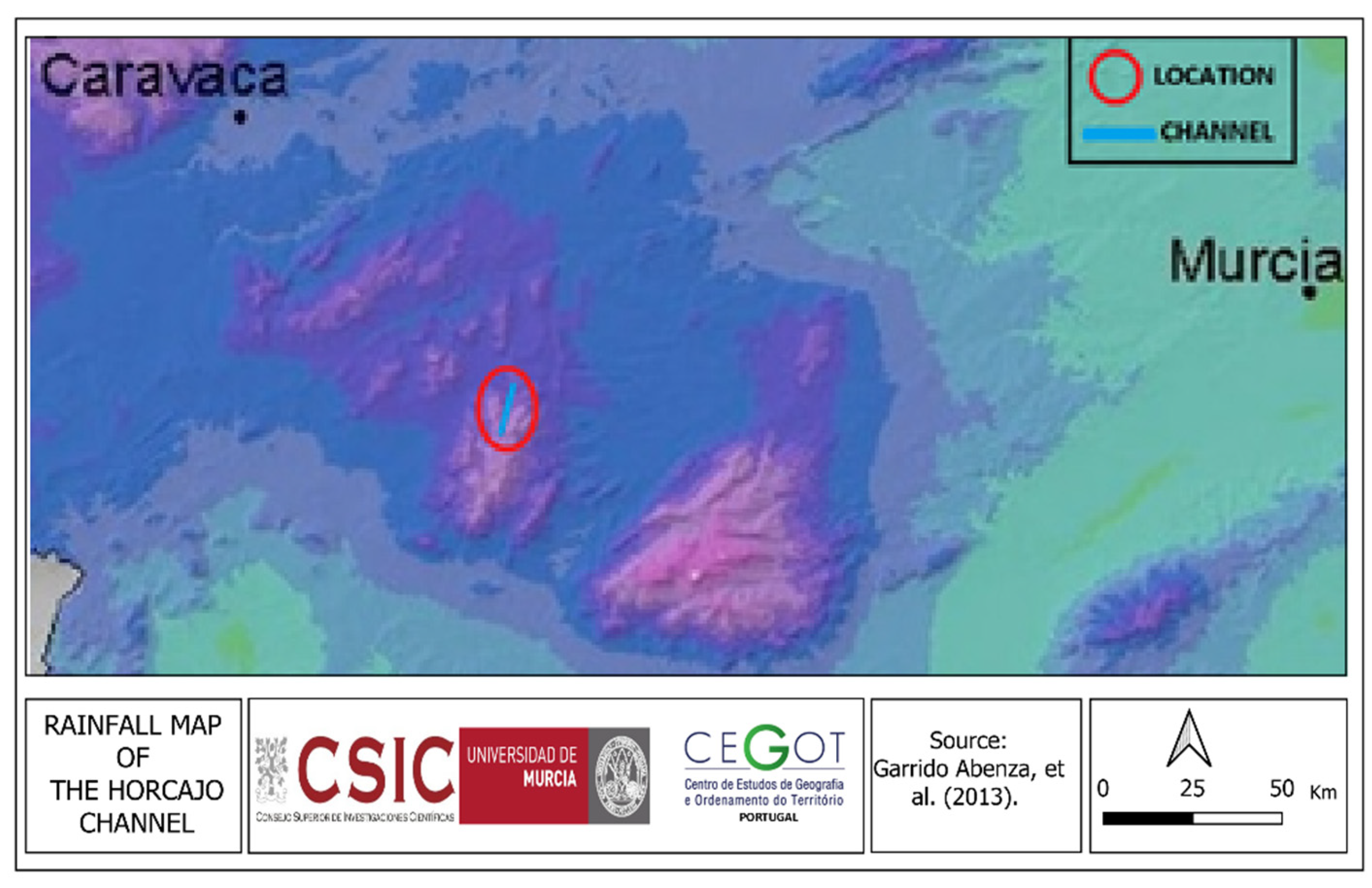
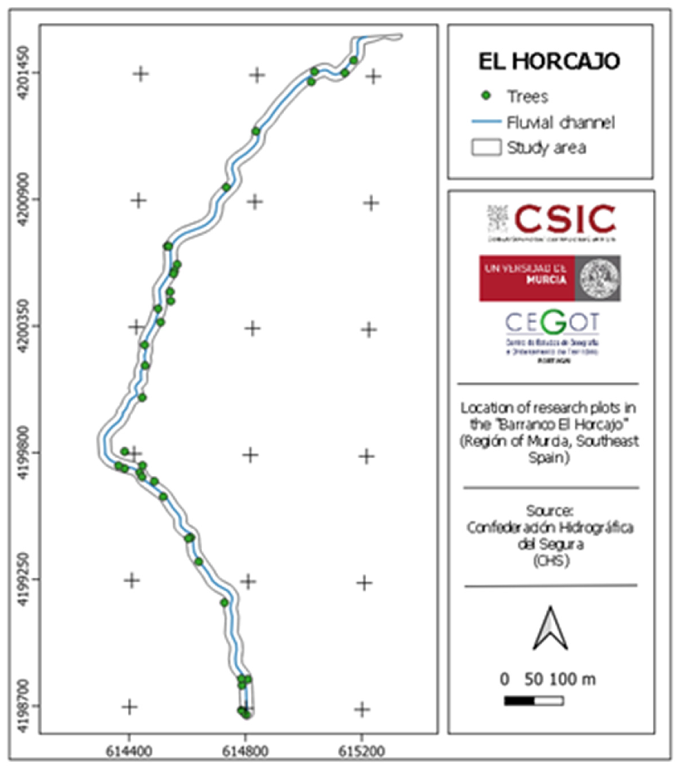
| Tree | 2006 | 2022 | ||||
| Margin | Mean | Margin | Mean | |||
| Right | Left | Right | Left | |||
| Total height | 4.70 | 4.53 | 4.65 | 6.35 | 7.61 | 6.83 |
| Volume | 0.042 | 0.041 | 0.0415 | 0.131 | 0.249 | 0.181 |
| Tree | Margin | Mean | |
| Right | Left | ||
| Total height | 35.10 | 67.99 | 46.88 |
| Volume | 169 | 507 | 336 |
| Canopy | 2006 | 2022 | ||||
| Margin | Mean | Margin | Mean | |||
| Right | Left | Right | Left | |||
| Surface (m) | 3.06 | 2.87 | 2.94 | 6.62 | 8.06 | 7.34 |
| Depth (m) | --- | --- | --- | 4.21 | 4.91 | 4.56 |
| Volume (m3) | --- | --- | --- | 27.87 | 39.55 | 33.70 |
| SPECIES | 2006 | 2022 | ||||||
| Margin | Margin | |||||||
| Right | Left | Right | Left | |||||
| 5 | 10 | 5 | 10 | 5 | 10 | 5 | 10 | |
| Acer monspessulanum L. | ||||||||
| Allium triquetrum L. | ||||||||
| Brachypodium retusum (Pers.) P.Beauv | ||||||||
| Dephne gnidium L. | ||||||||
| Erinacea anthyllis Link. | ||||||||
| Genista scorpius L. | ||||||||
| Helictotrichon filifolium Lag. | ||||||||
| Juniperus communis L. | ||||||||
| Lavandula latifolia Medicus | ||||||||
| Pinus halepensis Mill. | ||||||||
| Pinus nigra Arnold | ||||||||
| Quercus coccifera L. | ||||||||
| Quercus faginea Lam. | ||||||||
| Quercus rotundifolia Lam. | ||||||||
| Rhamnus lycioides L. | ||||||||
| Rosmarinus officinalis L. | ||||||||
| Stipa tenacissima L. | ||||||||
| Thymus spp. | ||||||||
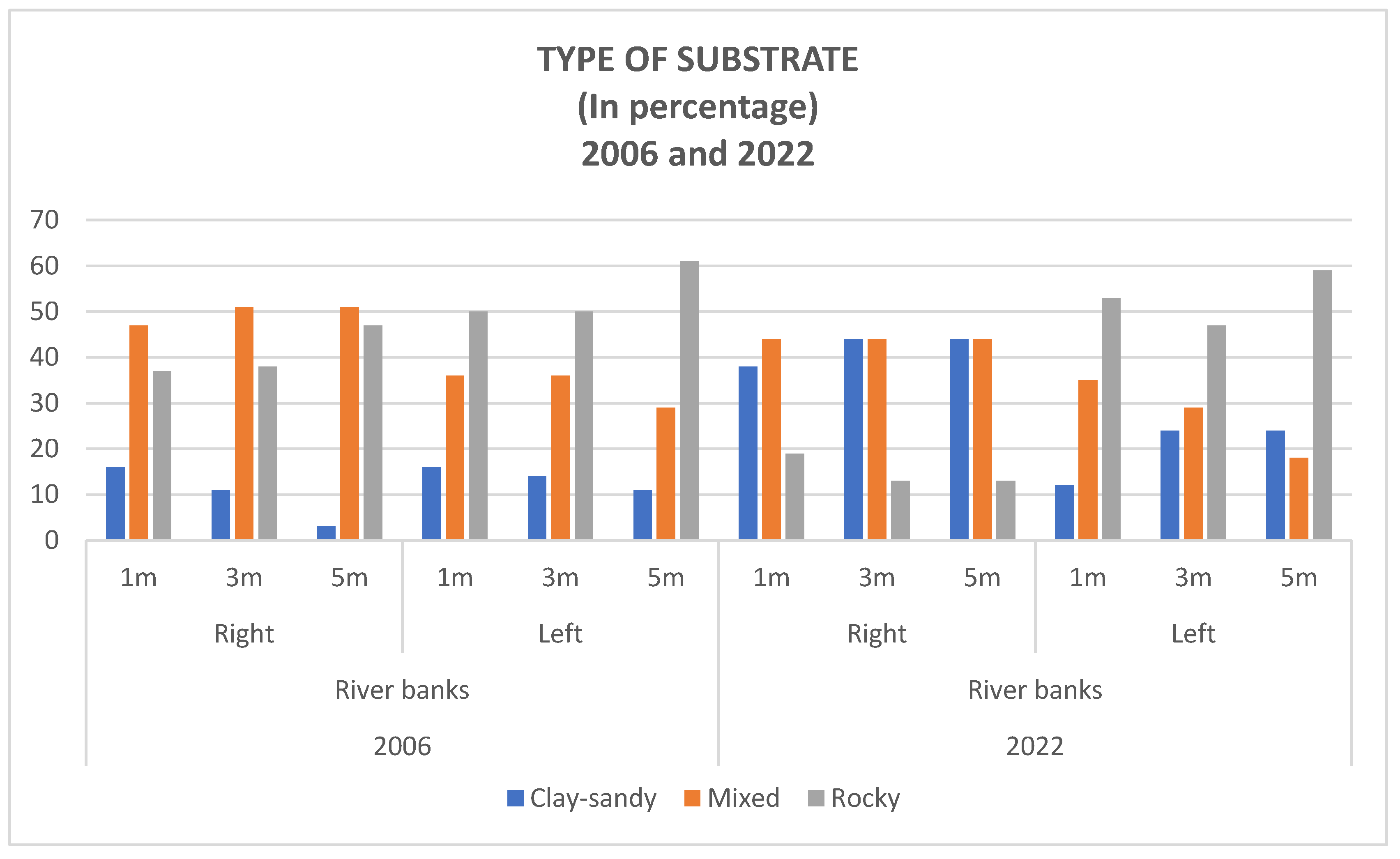
| 2006 | 2022 | |||||||||||
| Margin | Margin | |||||||||||
| Right | Left | Right | Left | |||||||||
| Lythology | 1m | 3m | 5m | 1m | 3m | 5m | 1m | 3m | 5m | 1m | 3m | 5m |
| Clay-Sand | 16 | 11 | 3 | 16 | 14 | 11 | 38 | 44 | 44 | 12 | 24 | 24 |
| Mixture | 47 | 51 | 51 | 36 | 36 | 29 | 44 | 44 | 44 | 35 | 29 | 18 |
| Rocky | 37 | 38 | 47 | 50 | 50 | 61 | 19 | 13 | 13 | 53 | 47 | 59 |
| Location | Altitude (m) | Orientation | Relief |
|---|---|---|---|
| Sierra de Salinas (Yecla) | 1000-1100 | Northeast | Ravine/Slope |
| Sierra de Villafuertes (Moratalla) | 1250 | North and East | Ravine/Slope |
| Río Mula (Bullas) | 630 | North | River/Slope |
| Carrascalejo (Bullas) | 600 | North | Ravine |
| Bco. Horcajo (Mula) | 900-1300 | North | Ravine/Slope |
| Sierra Espuña (Alhama de Murcia and yTotana) | 800-1000 | East | Ravine/Slope |
Disclaimer/Publisher’s Note: The statements, opinions and data contained in all publications are solely those of the individual author(s) and contributor(s) and not of MDPI and/or the editor(s). MDPI and/or the editor(s) disclaim responsibility for any injury to people or property resulting from any ideas, methods, instructions or products referred to in the content. |
© 2024 by the authors. Licensee MDPI, Basel, Switzerland. This article is an open access article distributed under the terms and conditions of the Creative Commons Attribution (CC BY) license (http://creativecommons.org/licenses/by/4.0/).


