Submitted:
13 February 2024
Posted:
14 February 2024
You are already at the latest version
Abstract
Keywords:
1. Introduction
2. Methods
2.1. Study Area
2.2. Stream Surveys
2.3. Data Analyses
3. Results
3.1. Riparian and Instream Variables: General Assessment
3.2. Canonical Correlations Modeling: Riparian Influence on Instream Habitat
3.3. Important Riparian and Instream Characteristics
4. Discussion
4.1. Major Findings
4.2. Management Implications
5. Conclusion
Author Contributions
Funding
Ethics approval - Compliance with ethical standards
Acknowledgments
Conflicts of Interest
References
- Wohl, E. Forgotten Legacies: Understanding and Mitigating Historical Human Alterations of River Corridors. Water Resour. Res. 2019, 55, 5181–5201. [Google Scholar] [CrossRef]
- Rosen, A.M. The impact of environmental change and human land use in alluvial valleys in the Loess Plateau of China during Middle Holocene. Geomorphology 2008, 101, 298–307. [Google Scholar] [CrossRef]
- Dotterweich, M. The history of human-induced soil erosion: Geomorphic legacies, early descriptions and research, and the development of soil conservation-A global synopsis. Geomorphology 2013, 201, 1–34. [Google Scholar] [CrossRef]
- Trimble, S.W. Historical Agriculture and soil Erosion in the Upper Mississippi Valley Hill Country. CRC Press; Boca Raton, Florida. 2013.
- Brown, A.G. Learning from the past: palaeohydrology and palaecology. Freshwater Bio. 2002, 47, 817–829. [Google Scholar] [CrossRef]
- Stenfert Kroese, J.; Batista, P.V.G.; Jacobs, S.R.; Breuer, L.; Quinton, J.N.; Rufino, M.C. Agricultural land is the main sources of stream sediments after conversion of an African montane forest. Sci. Rep. 2020, 10, 14827. [Google Scholar] [CrossRef]
- Graziano, M.P.; Deguire, A.K.; Surasinghe, T.D. Riparian Buffers as a Critical Landscape Feature: Insights for Riverscape Conservation and Policy Renovations. Diversity 2022, 14, 172. [Google Scholar] [CrossRef]
- Trimble, S.W., Jr.; Sartz, R.S. How far from a stream should a logging road be located? J. For. 1957, 55, 339–341. [Google Scholar]
- Froehlich, W. Sediment production from unmetalled road surfaces. Sediment and Stream Water Quality in a Changing Environment: Trends and Explanations. IAHS Publication, Wallingford, UK. 1991, 203, 21-30.
- Wolter, A.; Ward, B.; Millard, T. Instability eight sub-basins of the Chilliwack River Valley, British Columbia, Canada; a comparison of natural and logging-related landslide. Geomorphology 2010, 120, 123–132. [Google Scholar] [CrossRef]
- Wolman, M.G. A cycle of sedimentation and erosion in urban river channels. Geogr. Ann. Ser. A Phys Geogr. 1967, 49, 385–395. [Google Scholar] [CrossRef]
- Gregory, S.V.; Swanson, F.J.; McKee, W.A.; Cummins, K.W. An ecosystem perspective of riparian zones. BioScience. 1991, 41, 540–551. [Google Scholar] [CrossRef]
- Pusey, B.J.; Arthington, A.H. Importance of the riparian zone to the conservation and management of freshwater fish: a review. Mar. Freshwater Res. 2003, 54, 1–16. [Google Scholar] [CrossRef]
- Naiman, R.J.; Decamps, H. The ecology of interfaces: riparian zones. Annual Review of Ecology and Systematics. 1997, 28, 621–658. [Google Scholar] [CrossRef]
- Vannote, R.L.; Minshall, G.W.; Cummins, K.W.; Sedell, J.R.; Cushing, C.E. The river continuum concept. Can. J. Fish. Aquat. Sci. 1980, 37, 130–137. [Google Scholar] [CrossRef]
- Junk, W.J.; Bayley, P.B.; Sparks, R.E. The flood-pulse concept in river-floodplain systems. Can. Spec. Publ. Fish. Aqua. Sci. 1989, 106, 110–127. [Google Scholar]
- Anbumozhi, V.; Radhakrishnan, J.; Yamaji, E. Impact of riparian buffer zones on water quality and associated management considerations. Ecol. Eng. 2005, 24, 517–523. [Google Scholar] [CrossRef]
- Stutter, M.; Kronvang, B.; Huallachain, D.O.; Rozemeijer, J. Current insights into the effectiveness of riparian management, attainment of multiple benefits, and potential technical enhancements. J. Environ. Qual. 2019, 48, 236–247. [Google Scholar] [CrossRef] [PubMed]
- Lynch, JA.; Rishel, G.B.; Corbett, E.S. Thermal alteration of streams draining clearcut watersheds: quantification and biological implications. Hydrobiologia. 1984, 111, 161–169. [Google Scholar] [CrossRef]
- Oakley, A.L.; Collins, J.; Everson, L.; Heller, D.; Howerton, J.; Vincent, R. Riparian zones and freshwater wetlands. Management of Wildlife and Fish Habitats in Forest of Western Oregon and Washington; US Department of Agriculture, Forest Service: Pacific Northwest Region, USA, 1985; pp. 57–80. [Google Scholar]
- Everett, R.A.; Ruiz, G.M. Coarse woody debris as a refuge from predation in aquatic communities. Oecologia. 1993, 93, 475–486. [Google Scholar] [CrossRef]
- Sedell, J.R.; Reeves, G.H.; Hauer, F.R.; Stanford, J.A.; Hawkins, C.P. Role of refugia in recovery from disturbance: modern fragmented and disconnected river systems. Environ. Manage. 1990, 14, 711–724. [Google Scholar] [CrossRef]
- Fremier, A.K.; Kiparsky, M.; Gmur, S.; Aycrigg, J.; Craig, R.K.; Svancara, L.K.; Goble, D.D.; Cosens, B.; Davis, F.W.; Scott, J.M. A riparian conservation network for ecological resilience. Biol. Conserv. 2015, 191, 29–37. [Google Scholar] [CrossRef]
- Lawson, J.R.; Fryirs, K.A.; Lenz, T.; Leishman, M.R. Heterogeneous flows foster heterogeneous assemblages: relationships between functional diversity and hydrological heterogeneity in riparian plant communities. Freshwater Biol. 2015, 60, 2208–2225. [Google Scholar] [CrossRef]
- Wellnitz, T.; Poff, N.L. Functional redundancy in heterogeneous environments: Implications for conservation. Ecol. Lett. 2001, 4, 177–179. [Google Scholar] [CrossRef]
- Kotschy, K.; Biggs, R.; Daw, T.; Folke, C.; West, P. “Principle 1 – maintain diversity and redundancy”. Principles for building resilience: Sustaining ecosystem services in social-ecological systems. Cambridge: Cambridge University Press. 2015, 50-75.
- Mundahl, N.D.; Varela, W.L.; Weaver, C.; Mundahl, E.D.; Cochran-Biederman, J.L. Stream habitats and aquatic communities in an agricultural watershed: changes related to a mandatory riparian buffer law. Environ. Manage. 2023, 5, 945–958. [Google Scholar] [CrossRef]
- Jowett, L.G.; Richardson, J.; Boubée, J.A.T. Effects of riparian manipulation on stream communities in small streams: two case studies. N.Z.J. Mar. Freshwater Res. 2009, 43, 763–774. [Google Scholar] [CrossRef]
- Smith, C.M. Riparian pasture retirement effects on sediment, phosphorus and nitrogen in channelised surface run-off from pastures. N.Z.J. Mar. Freshwater Res. 1989, 23, 139–146. [Google Scholar] [CrossRef]
- Opperman, J.J.; Merenlender, A.M. The effectiveness of Riparian Restoration for Improving Fish Habitat in Four Hardwood-Dominated California Streams. North Am. J Fish. Manage. 2004, 24, 822–834. [Google Scholar] [CrossRef]
- Houston, W.A.; Black, R.L.; Wormington, K.R. Grasslands of cleared woodlands have lower invertebrate diversity and different assemblages to remnant woodlands in grazed landscapes of eastern Australia. J. Insect Conserv. 2023, 27, 999–1011. [Google Scholar] [CrossRef]
- Wiens, J.A. “Ecological heterogeneity: An ontogeny of concepts and approaches”. The ecological consequences of environmental heterogeneity. Hoboken: Blackwell Science. 1999.
- Brierley, G.J. “The socio-ecological river, Socio-economic, cultural and environmental relations to river systems”. Finding the Voice of the River: Beyond Restoration and Management. Springer International Publishing AG. 2020, 29-60.
- Allan, J.D. Landscapes and riverscapes: the influence of land use on stream ecosystems. Annual review of ecology and systematics. 2004, 35, 257–284. [Google Scholar] [CrossRef]
- Gordon, L.J.; Peterson, G.D.; Bennet, E.M. Agricultural modifications of hydrological flows create ecological surprises. Trends in Ecol. Evol. 2007, 23, 211–219. [Google Scholar] [CrossRef]
- Armour, C.L.; Duff, D.A.; Elmore, W. The effects of livestock grazing on riparian and stream ecosystems. Fisheries. 1991, 16, 7–11. [Google Scholar] [CrossRef]
- Battaglin, W.; Fairchild, J. Potential toxicity of pesticides measured in midwestern streams to aquatic organisms. Water Sci Technol. 2002, 45(9), 95–102. [Google Scholar] [CrossRef] [PubMed]
- Moss, B. Water pollution by agriculture. Phils. Trans. R. Soc. London, Ser. B 2008, 363, 659–666. [Google Scholar]
- McTammany, M.E.; Benfield, E.F.; Webster, J.R. Recovery of stream ecosystem metabolism from historical agriculture. J.N. Am. Benthol. Soc. 2007, 26, 532–545. [Google Scholar] [CrossRef]
- Thorp, J.H.; Thoms, M.C.; Delong, M.D. The Riverine Ecosystem Synthesis: Toward Conceptual Cohesiveness in River Science. Academic Press: London, UK, 2008.
- Matson, P.A.; Parton, W.J.; Power, A.J.; Swift, M.J. Agricultural intensification and ecosystem properties. Science. 1997, 277, 504–509. [Google Scholar] [CrossRef] [PubMed]
- Whitewater River Watershed Project. A history of the Whitewater Watershed in Minnesota. Whitewater River Watershed Project, Lewiston, Minnesota. 2015.
- Trout Unlimited. The Economic Impact of Trout Angling in the Driftless Area. 2016.
- Nerbonne, B.A.; Vondracek, B. Effects of local land use on physical habitat, benthic macroinvertebrates, and fish in the Whitewater River, Minnesota, USA. Environ. Manage. 2001, 28, 87–99. [Google Scholar] [CrossRef] [PubMed]
- Williams, M.A.; Vondracek, B. Spring distributions and relationships with land cover and hydrogeologic strata in a karst landscape in Winona County, Minnesota, USA. Carbonates and Evaporites. 2010, 25, 333–347. [Google Scholar] [CrossRef]
- Varela, W.L.; Mundahl, N.D.; Bergen, S.; Staples, D.F.; Cochran-Biederman, J.; Weaver, C.R. Physical and Biological Stream Health in an Agricultural Watershed after 30+ Years of Targeted Conservation Practices. Water 2023, 15, 3475. [Google Scholar] [CrossRef]
- Minnesota Pollution Control Agency. Mississippi River (Winona) watershed monitoring and assessment report. Minnesota Pollution Control Agency, St. Paul. 2013.
- Platts, W.S.; Megahan, W.F.; Minshall, G.W. Methods for evaluating stream, riparian, and biotic conditions. U.S. Department of Agriculture, Forest Service, Intermountain Forest and Range Experiment Station Technical Report INT-138. 1982.
- Zar, J.H. Biostatistical Analysis. Prentice Hall Inc. Upper Saddle River, New Jersey. 1999.
- Rencher, A.C.; Christensen, W.F. Methods of Multivariate Analysis. Wiley Series in Probability Statistics 3rd edition. John Wiley and Sons Inc. 2012. [Google Scholar]
- Degani, A.; Shafto, M.; Olson, L. Canonical correlation analysis: Use of composite heliographs for representing multiple patterns. International Conference on Theory and Application of Diagrams. Berlin, Heidelberg: Springer Berlin Heidelberg. 2006, 93-97.
- Mundahl, N.D.; Mundahl, E.D. Aquatic community structure and stream habitat in a karst agricultural landscape. Ecol. Processes. 2022, 11, 1–16. [Google Scholar] [CrossRef]
- Yates, A.G.; Bailey, R.C.; Schwindt, J.A. Effectiveness of best management practices in improving stream ecosystem quality. Hydrobiologia. 2007, 583, 331–344. [Google Scholar] [CrossRef]
- Barker, L.S.; Felton, Z.G.K.; Russek-Cohen, E. Use of Maryland biological stream survey data to determine effects of agricultural riparian buffers on measure of biological stream health. Environ. Monit. Assess. 2006, 117, 1–19. [Google Scholar] [CrossRef]
- Meleason, M.A.; Gregory, S.V.; Bolte, J.P. Implications of Riparian Management Strategies on Wood in Streams of the Pacific Northwest. Ecol. Appl. 2003, 13, 1212–1221. [Google Scholar] [CrossRef]
- Tabacchi, E.; Correll, D.L.; Hauer, R.; Pinay, G.; Planty-Tabacchi, A.M.; Wissmar, R.C. Development, maintenance, and role of riparian vegetation in the river landscape. Freshwater Biol. 1998, 40, 497–516. [Google Scholar] [CrossRef]
- Knight, K.W.; Schultz, R.C.; Mabry, C.M.; Isenhart, T.M. Ability of remnant riparian forests, with and without grass filters, to buffer concentrated surface runoff. J. Am. Water Resour. Assoc. 2010, 46, 311–322. [Google Scholar] [CrossRef]
- Duehr, J.P.; Siepker, M.J.; Pierce, C.L.; Isenhart, T.M. relation of riparian buffer strips to in-stream habitat, macroinvertebrates and fish in a small Iowa stream. J. Iowa Acad. Sci. 2006, 113, 101–107. [Google Scholar]
- Tapsell, S.M. River restoration: what are we restoring to? A case study of the Ravensbourne river, London. Landsc. Res. 1995, 20, 98–111. [Google Scholar] [CrossRef]
- Wohl, E.; Lane, S.N.; Wilcox, A.C. The science and practice of river restoration. Water Resour. Res. 2015, 51, 5974–5997. [Google Scholar] [CrossRef]
- Palmer, M.A.; Menninger, H.; Bernhardt, S.E. River restoration, habitat heterogeneity and biodiversity: a failure of theory or practice? Freshwater Biol. 2010, 55, 205–222. [Google Scholar] [CrossRef]
- Vidon, P.G.; Welsh, M.K.; Hassanzadeh, Y.T. Twenty Years of Riparian Zone Research (1997-2017): Where to Next? J. Environ. Qual. 2018, 48, 248–260. [Google Scholar] [CrossRef]
- Kroll, S.A.; Oakland, H.C. A review of studies documenting the effects of agricultural best management practices on physiochemical and biological measure of stream system integrity. Nat. Areas J. 2019, 39, 58–77. [Google Scholar] [CrossRef]
- Pearce, N.J.T.; Yates, A.G. Agricultural best management practices abundance and location does not influence stream ecosystem function of water quality in the summer season. Water 2015, 7, 6861–6876. [Google Scholar] [CrossRef]
- James, L.A. Legacy sediment: Definitions and processes of episodically produced anthropogenic sediment. Anthropocene. 2013, 2, 16–26. [Google Scholar] [CrossRef]
- Hunt, L. South Branch Whitewater River Unified Fish Kill Response. Minnesota Department of Agriculture, St. Paul. 2015, 367.
- Tornlund, E.; Ostlund, L. Floating timber in northern Sweden: The construction of floatways and transformation of rivers. Environ. His. 2002, 8, 85–106. [Google Scholar] [CrossRef]
- Brierley, G.J.; Brooks, A.P.; Fryirs, K.; Taylor, M.P. Did humid-temperate rivers in the Old and New Worlds respond differently to clearance of riparian vegetation and removal of woody debris? Prog. Phys. Geogr. 2005, 29, 27–49. [Google Scholar] [CrossRef]
- Pišút, P. Channel evolution of the pre-channelized Danube River in Bratislava, Slovakia (1712-1886). Earth Surf. Processes Landforms. 2002, 27, 369–390. [Google Scholar] [CrossRef]
- Phillips, J.D.; Park, L. Forest blowdown impacts of Hurricane Rita on fluvial systems. Earth Surf. Processes Landforms. 2009, 34, 1069–1081. [Google Scholar] [CrossRef]
- Greenwood, M.J.; Harding, J.S.; Niyogi, D.K.; McIntosh, A.R. Improving the effectiveness of riparian management for aquatic invertebrates in a degraded agricultural landscape: stream size and land-use legacies. J. Appl. Ecol. 2012, 49, 213–222. [Google Scholar] [CrossRef]
- Quinn, J.M.; Williamson, R.B.; Smith, R.K.; Vickers, M.V. Effects of riparian grazing and channelisation on streams in Southland, New Zealand. 2. Benthic Invertebrates. N.Z.J. Mar. Freshwater Res. 1992, 26, 259–269. [Google Scholar] [CrossRef]
- Bunn, S.E.; Davies, P.M.; Mosisch, T.D. Ecosystem measures of river health and their response to riparian and catchment clearing. Freshwater Biol. 1999, 41, 333–346. [Google Scholar] [CrossRef]
- Walser, C.A.; Bart Jr, H.L. Influence of agriculture on instream habitat and fish community structure in Piedmont watersheds of the Chattahoochee River system. Ecol. Freshwater Fish. 1999, 8, 237–246. [Google Scholar] [CrossRef]
- Blinn, C.R.; Kilgore, M.A. Riparian Management Practices: a summary of state guidelines. J. For. 2001, 99, 11–17. [Google Scholar]
- McKergow, L.A.; Matheson, F.E.; Quinn, J.M. Riparian management: A restoration tool for New Zealand streams. Ecological Management and Restoration. 2016, 17(3), 218–227. [Google Scholar] [CrossRef]
- Hansen, B.; Reich, P.; Cavagnaro, T.; Lake, P.S. Challenges in applying scientific evidence to width recommendations for riparian management in agricultural Australia. Ecol. Manage. Restor. 2015, 16, 50–57. [Google Scholar] [CrossRef]
- Welcomme, R.L. Fisheries Ecology of Floodplain Rivers. Longman: London, UK. 1979.
- Death, R.G.; Collier, K.J. Measuring stream macroinvertebrate responses to gradients of vegetation cover: when is enough enough? Freshwater Biol. 2010, 55, 1447–1464. [Google Scholar] [CrossRef]
- Gregory, S.V. Riparian management in the 21st century. Creating a forestry for the 21st century: the science of ecosystem management. Island Press, Washington, D.C., USA. 1997, 69-86.
- Boothroyd, I.K.G.; Langer, E.R. Forest harvesting and riparian management guidelines: a review. Technical Report 56. National Institute of Water and Atmospheric Research, Hamilton, New Zealand. 1999.
- Majer, J.D.; De Sousa-Majer, M.J.; Heterick, B.E. Partial clearing of a road corridor leads to homogenisation of the invertebrate fauna. Pac. Conserv. Biol. 2021, 27, 70–85. [Google Scholar] [CrossRef]
- Lovett, G.M.; Burns, D.A.; Driscoll, C.T.; Jenkins, J.C.; Mitchell, M.J.; Rustad, L.; Shanley, J.B.; Likens, G.E.; Haeuber, R. Who needs environmental monitoring? Front. Ecol. Environ. 2007, 5, 253–260. [Google Scholar] [CrossRef]
- Swartz, A.; Roon, D.; Reiter, M.; Warren, D. Stream temperature responses to experimental riparian canopy gaps along forested headwaters in western Oregon. For. Ecol. Manage. 2020, 474, 118354. [Google Scholar] [CrossRef]
- Kuglerová, L.; Muotka, T.; Chellaiah, D.; Jyväsjärvi, J.; Richardson, J.S. Protecting our streams by defining measurable targets for riparian management in a forestry context. J. Appl. Ecol. 2023, 00, 1–9. [Google Scholar] [CrossRef]
- Hunter, M.L.; Acuña, V.; Bauer, D.M.; Bell, K.P.; Calhoun, A.J.K.; Felipe-Lucia, M.R.; Fitzsimons, J.A.; González, E.; Kinnison, M.; Lindenmayer, D.; Lundquist, C.; Medellin, R.A.; Nelson, E.J. Conserving small natural features with large ecological role: a synthetic overview. Biol. Conserv. 2017, 211, 88–95. [Google Scholar] [CrossRef]
- González, E.; Felipe-Lucia, M.R.; Bourgeois, B.; Boz, B.; Nilsson, C.; Palmer, G.; Sher, A.A. Integrative conservation of riparian zones. Biol. Conserv. 2017, 211, 20–29. [Google Scholar] [CrossRef]
- Garssen, A.G.; Verhoeven, J.T.A.; Soons, M.B. Effects of climate-induced increases in summer drought on riparian plant species: a meta-analysis. Freshwater Biol. 2014, 59, 1052–1063. [Google Scholar] [CrossRef] [PubMed]
- Katz, G.L.; Friedman, J.M.; Beatty, S.W. Delayed effects of flood control on a flood-dependent riparian forest. Ecol. Appl. 2005, 15, 1019–1035. [Google Scholar] [CrossRef]


| Variable | North | Middle | South | F | P |
|---|---|---|---|---|---|
| Riparian Variables | |||||
| Shade % | 52 (27) | 34 (24) | 34 (29) | 2.57 | 0.086 |
| AOV (cm) | 16 (18) | 12 (13) | 18 (20) | 1.33 | 0.273 |
| WRB (m) | 103 (38) | 127 (28) | 98 (37) | 1.12 | 0.334 |
| Rock % | 8 (13) | 10 (13) | 4 (6) | 0.96 | 0.387 |
| Bare soil % | 39 (23) | 30 (26) | 43 (28) | 1.61 | 0.209 |
| Grass % | 37 (25) | 39 (27) | 41 (26) | 0.11 | 0.899 |
| Forbs % | 12 (14) | 19 (19) | 12 (14) | 1.82 | 0.170 |
| Shrub % | 1 (2) | 0.4 (2) | 1 (2) | 0.49 | 0.615 |
| Tree % | 3 (6) | 2 (4) | 2 (5) | 0.81 | 0.450 |
| Instream Variables | |||||
| Width/Depth | 7 (4) | 7 (4) | 7 (2) | 0.11 | 0.893 |
| CV (cm-1) | 28 (21) | 35 (25) | 35 (25) | 1.83 | 0.170 |
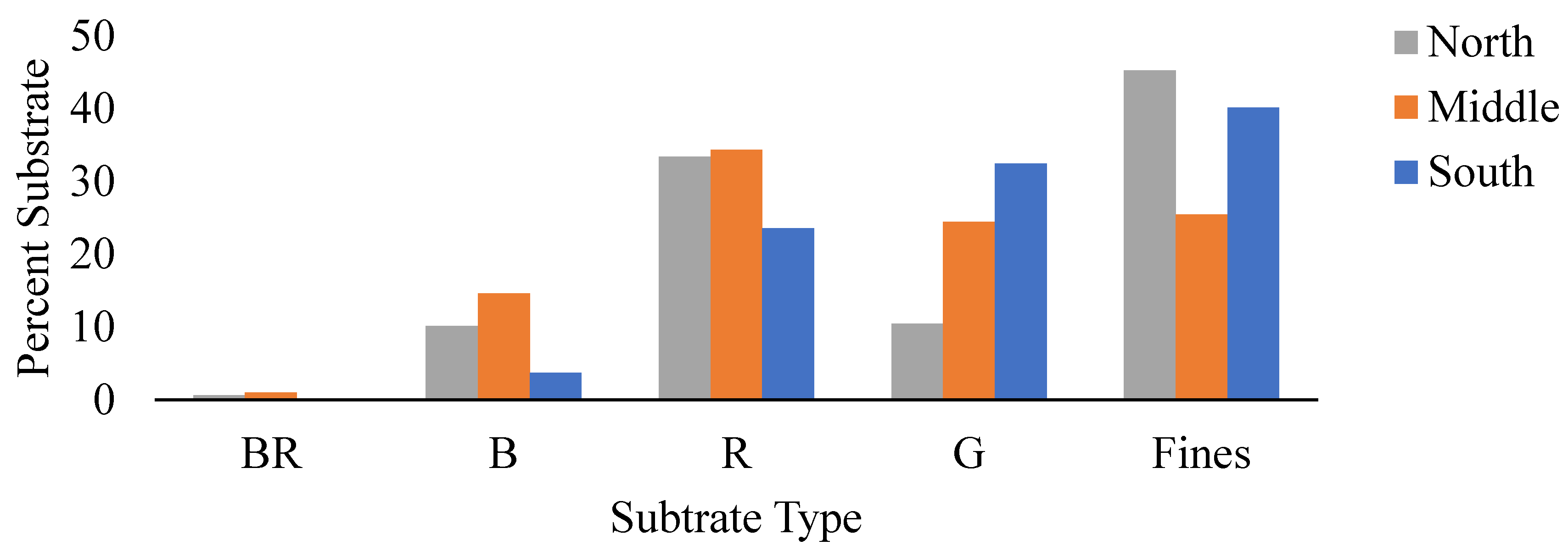
| Fines % | 41 | 25 | 43 | 3.23 | 0.04* |
| Gravel % | 10 | 24 | 30 | 5.77 | 0.005* |
| Rubble % | 30 | 34 | 21 | 1.68 | 0.196 |
| Boulder % | 9 | 15 | 3 | 2.47 | 0.094 |
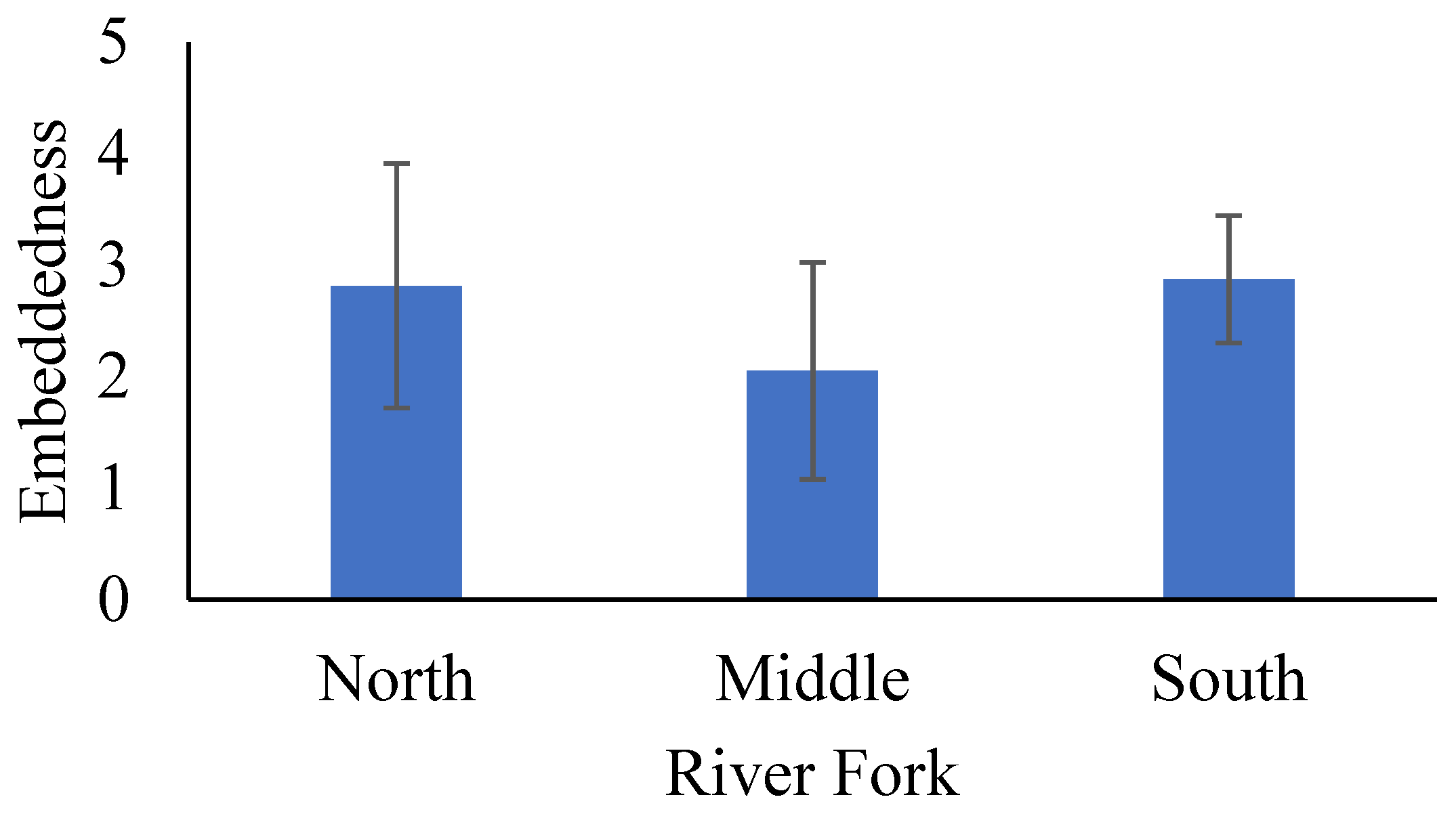
| Embed | 2.8 (1.1) | 2.1 (0.9) | 2.9 (0.6) | 5.15 | 0.009* |
| Riffle % | 21 (28) | 36 (39) | 21 (34) | 2.05 | 0.03* |
| Run % | 55 (37) | 53 (39) | 70 (37) | 3.58 | 0.03* |
| Pool % | 23 (27) | 11 (20) | 9 (16) | 5.58 | 0.006* |
| Cover % | 33 (26) | 25 (20) | 20 (18) | 3.66 | 0.03* |
| Variate | Corr | F | P |
|---|---|---|---|
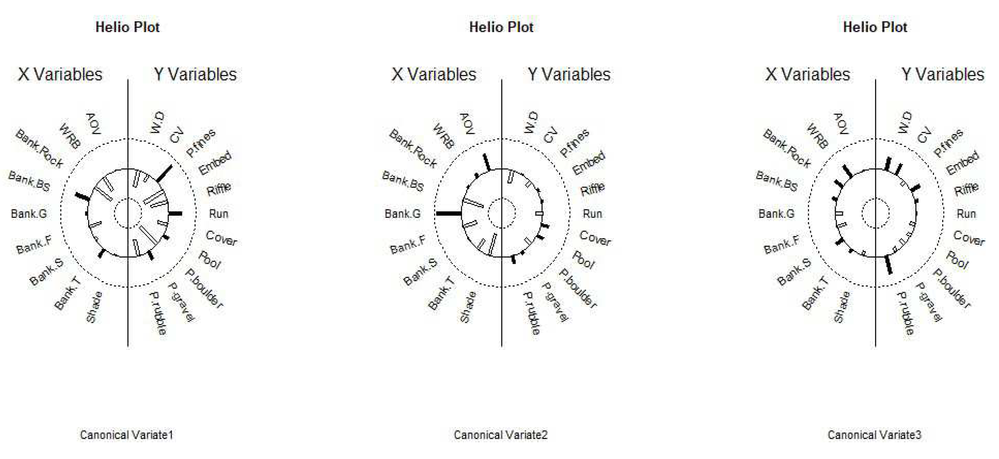
| 1 | 0.893 | 2.4356 | > 0.00001**** |
| 2 | 0.789 | 1.7832 | 0.0004*** |
| 3 | 0.722 | 1.429 | 0.0311* |
| 4 | 0.617 | 1.1038 | 0.313 |
| 5 | 0.586 | 0.8665 | 0.683 |
| 6 | 0.38 | 0.4577 | 0.986 |
| 7 | 0.247 | 0.2755 | 0.996 |
| 8 | 0.164 | 0.1721 | 0.994 |
| 9 | 0.059 | 0.0525 | 0.983 |
| Fork | Typical Riparian Characteristics | Typical Instream Characteristics |
|---|---|---|
| North | High % Shade; Wide Buffer; High % Bare Soil; Less % Grass | Low Width/Depth; Slow Flow; High % Fines; Moderate Rubble; High Embeddedness; High % Run |
| Middle | Wide Buffers; High % Grasses; Low % Shade; Less Forbs; Low % Bank Rock | Fast Flow; Low Width/Depth; Low Fines; Moderate % Gravel; Moderate % Rubble; Low Embeddedness; High % Riffles |
| South | Narrow Buffer; Low % Shade; Overhanging Vegetation; High % Bare Soil; High % Grass; | Low Width/Depth; Fast Flow; High % Fines; Moderate % Gravel; Low % Rubble; High Embeddedness; High % Run; Low % Pools |
Disclaimer/Publisher’s Note: The statements, opinions and data contained in all publications are solely those of the individual author(s) and contributor(s) and not of MDPI and/or the editor(s). MDPI and/or the editor(s) disclaim responsibility for any injury to people or property resulting from any ideas, methods, instructions or products referred to in the content. |
© 2024 by the authors. Licensee MDPI, Basel, Switzerland. This article is an open access article distributed under the terms and conditions of the Creative Commons Attribution (CC BY) license (https://creativecommons.org/licenses/by/4.0/).


