Submitted:
03 April 2024
Posted:
03 April 2024
You are already at the latest version
Abstract
Flooding, exacerbated by climate change, poses a significant threat to certain areas, increasing in frequency and severity. In response, the construction of supplementary dams has emerged as a reliable solution for flood management. This study employs a Remote Sensing (RS) approach integrated with GIS to assess the feasibility of constructing a supplementary dam near Linville, Brisbane, Australia, with the aim of mit-igating floods and preventing overtopping failure at the Wivenhoe Dam. Using QGIS software and a 25-meter resolution DEM from the Queensland Spatial Catalogue ‘QSpatial’ website, four potential dam sites were analysed, considering cross-sections, watershed characteristics, and water volume calculations. Systematic selection criteria were applied to identify the most optimal option based on dam wall di-mensions, volume-to-area, and volume-to-cost ratios. The selected option was further assessed against predefined criteria, yielding one optimal choice. The study provides insights into the feasibility and ef-fectiveness of supplementary dam construction for flood mitigation in the region, with recommendations for future research and implementation.
Keywords:
Climate Change
; Flooding
; Dam Surveying
; GIS
; DEM
; Selection criteria
1. Introduction
Climate change is the long-term shift in temperature and precipitation that affects human life Climate change is the long-term shift in temperature and precipitation that affects human life [1]. According to Yoro and Daramola [2], the severe consequences of climate change will continue to affect Earth, and the average surface temperature of the Earth is likely to exceed 3°C in this century. A climate report from CSIRO and the Bureau of Meteorology [3], highlighted that Australia's climate is warming by about 1.4°C since 1910. Consequently, higher evaporation levels will intensify water cycle potentially cause extreme precipitation and flooding [1]. According to Lempérière [4], climate change increases the annual probability of precipitation by 10% to 20% leading to 20% increase in related floods. Consequently, climate model projections indicated a concerning trend of increased flooding a cross various regions in Australia, particularly in south-eastern Australia. Where the frequency of devastating once-in-100-year flood events may occur as frequently as once every 10 years in the future [4,5]. Queensland Reconstruction Authority highlighted that floods cause more damage in Queensland than any other natural disaster, with frequent occurrences in the Brisbane River due to heavy rainfall events [6].
This presents a significant challenge for disaster management, as a response to this potential threat, controlling excessive rainfall flow to mitigate floods and prevent potential disasters, can be achieved by constructing a reservoir, which can reduce the downstream flow [7,8]. Wivenhoe Dam was built in response to the 1974 flood event, where both Brisbane and Ipswich experienced their highest river levels since 1893, resulting in extensive damage and loss of lives [9]. Dams are erected to stop or restrict the natural flow of water, allowing to accumulate in a reservoir [10]. This process serves the primary purpose of holding water for drinking, domestic use, and flood management. However, selecting an optimal dam location is crucial, considering financial, population, and environmental factors [11]. Proper planning of dam construction can prevent or mitigate flooding improving rainwater use efficiency. This paper therefore proposes a GIS and remote sensing approach for a dam site selection. Where, GIS and Remote sensing stands out as robust techniques for tracking and monitoring environmental changes and disasters resulted from Climate change, offering a wide ranging multi-temporal database [12]. The first section outlines the background of the problem and the objectives of the study. The subsequent section delves into the role of geospatial analysis in effectively addressing relevant issues. Following that, the bases for selecting the study area are highlighted, with support from the geospatial approach. Test results are then reported, and a discussion is conducted based on critical criteria for selecting the optimal dam wall location. The last section encompasses conclusions, concluding with recommendations for possible further improvements. According to Yoro and Daramola [2], the severe consequences of climate change will continue to affect Earth, and the average surface temperature of the Earth is likely to exceed 3°C in this century. A climate report from CSIRO and the Bureau of Meteorology [3], highlighted that Australia's climate is warming by about 1.4°C since 1910. Consequently, higher evaporation levels will intensify water cycle potentially cause extreme precipitation and flooding [1]. According to Lempérière [4], climate change increases the annual probability of precipitation by 10% to 20% leading to 20% increase in related floods. Consequently, climate model projections indicated a concerning trend of increased flooding a cross various regions in Australia, particularly in south-eastern Australia. Where the frequency of devastating once-in-100-year flood events may occur as frequently as once every 10 years in the future [4,5]. Queensland Reconstruction Authority highlighted that floods cause more damage in Queensland than any other natural disaster, with frequent occurrences in the Brisbane River due to heavy rainfall events [6].
This presents a significant challenge for disaster management, as a response to this potential threat, controlling excessive rainfall flow to mitigate floods and prevent potential disasters, can be achieved by constructing a reservoir, which can reduce the downstream flow [7,8]. Wivenhoe Dam was built in response to the 1974 flood event, where both Brisbane and Ipswich experienced their highest river levels since 1893, resulting in extensive damage and loss of lives [9]. Dams are erected to stop or restrict the natural flow of water, allowing to accumulate in a reservoir [10]. This process serves the primary purpose of holding water for drinking, domestic use, and flood management. However, selecting an optimal dam location is crucial, considering financial, population, and environmental factors [11]. Proper planning of dam construction can prevent or mitigate flooding improving rainwater use efficiency. This paper therefore proposes a GIS and remote sensing approach for a dam site selection. Where, GIS and Remote sensing stands out as robust techniques for tracking and monitoring environmental changes and disasters resulted from Climate change, offering a wide ranging multi-temporal database [12]. The first section outlines the background of the problem and the objectives of the study. The subsequent section delves into the role of geospatial analysis in effectively addressing relevant issues. Following that, the bases for selecting the study area are highlighted, with support from the geospatial approach. Test results are then reported, and a discussion is conducted based on critical criteria for selecting the optimal dam wall location. The last section encompasses conclusions, concluding with recommendations for possible further improvements.
2. Statement of Problem
2.1. Wivenhoe Dam: Case Study
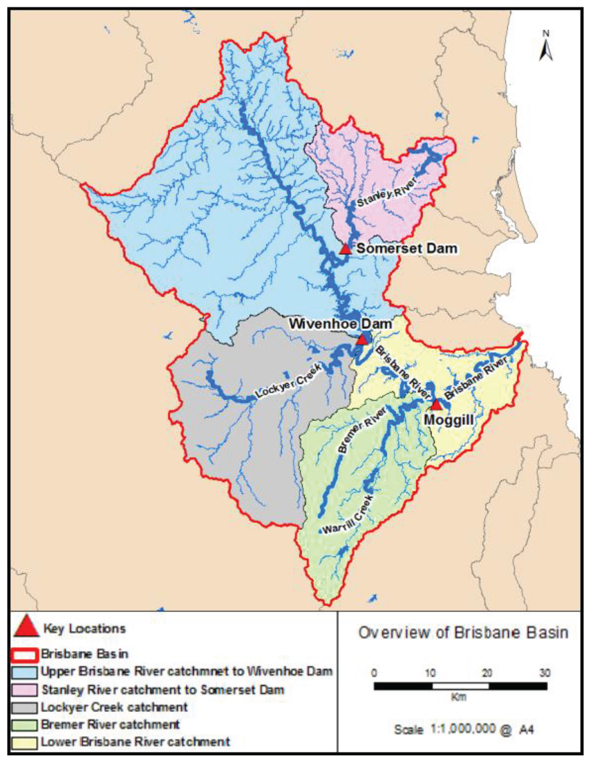
Wivenhoe Dam (Figure 1), the largest in southeast Queensland, has a full supply capacity of 1.165 million megalitres (constituting 45.3% of Queensland water, Figure 2) and a flood mitigation capacity of 1.967 million megalitres. The dam is located upstream of the Brisbane River (80 kilometres from Brisbane City) with a wall length of 2300m. Wivenhoe dam is an earth and rock embankment with a concrete spillway contains five massive steel gates 12.0m in width and 16.6 m in height [13]. During intense local rain, the dam's five steel gates open to release excess water, maintaining a controllable reservoir level. The dam primarily serves to supply essential water to Brisbane and surrounding areas (see Figure 3) and plays a crucial role in flood mitigation and power generation.
According to the flood history study by Queensland Reconstruction Authority [15], Brisbane River has experienced frequent flooding documented since 1824 due to heavy rainfall in the catchment, becoming an integral part of city life. For instance, the 1974 flood caused $200 million in damage and the loss of 14 lives, served as the main impetus to construct Wivenhoe Dam. While in the 2011, instant rainfall triggered flash floods in Toowoomba and Lockyer Valley, resulting major river flooding in Brisbane and Ipswich, resulting in $15.9 billion in damage. The February 2022 flood event affected 91% of Brisbane suburbs, causing $2.5 billion in property damage [16]. Furthermore, Wivenhoe and Somerset (a dam on one of the two upper streams of Wivenhoe dam) dams reached unprecedented levels at 183.9% and 148.0%, respectively, marking the highest water storage in their history. Notably, three major floods occurred in less than 50 years, emphasising the need of flood management plans. However, Wivenhoe Dam is a rock and earth-fill embankment dam; it has a clay core and an earthen wall lined on the outside with rocks [17]. Unlike the Somerset Dam's concrete wall, Wivenhoe Dam lacks a structure to tolerate the pressure of water flowing over the wall [17]. Water from Somerset Dam and the upper Brisbane River feeds Wivenhoe Dam, (see Figure 3). During intense rainfall periods, the water level in the reservoir rises creating substantial pressure making the dam wall vulnerable to failure. Gates are consequently opened to release water and reduce pressure. However, this solution raises the volume of water flowing into Brisbane city, creating a new challenge for downstream areas of Wivenhoe Dam, especially in flooding events. Additionally, major creeks beneath the dam combine with the Brisbane River and escalating the river's enlarged flow already resulting in difficult water control in these locations (see Figure 3). This terrific flooding in Brisbane poses a crucial risk to human life and causes many of infrastructure damage. On the other hand, reducing the water inflow from the Brisbane River by retaining water within the dam is considered dangerous and may cause extra pressure on the Dam wall. Wivenhoe dam failure could expose more than 300,000 people downstream to danger and destroy infrastructure worth of $100 billion [18]. In fact, the Queensland Government has suggested constructing a supplementary dam or raising the Wivenhoe Dam wall to protect communities in Brisbane and Ipswich [19]. However, no final decision has been made. Nevertheless, raising the dam wall increases the potential failure risk due to the significant increase in the pressure from the dead load of the wall as well as the ceased water [18]. Therefore, this study aims to find a suitable location for a supplementary dam that can share significant amount of water from the Wivenhoe catchment area, alleviate the pressure on the dam wall, and provide an additional source of water.
Figure 3.
Overview of Brisbane catchments [20].
Figure 3.
Overview of Brisbane catchments [20].
2.2. Pre-Feasibility Study for New Dam Development
Dam is a huge infrastructure that requires planning and analysis of critical data which usually takes a period of 2 to 10 years to ensure taking right decision [21]. According to Petheram, Gallant [21], a pre-feasibility assessment is required for the construction of a potential dam due to the significant costs and time involved in the construction associated with such huge infrastructures. This pre-feasibility assessment requires extensive initial investigations that examines comprehensively all potential dam construction sites considering the topography, morphology, geological structure, size of the catchment area, and the cost efficiency.
2.3. Scope of the Work and Study Objectives
The proposed work aims to identify an optimal site selection of a supplementary dam in Brisbane, QLD Australia. This dam would serve the purpose of managing large volumes of water during sudden flood events and heavy localised rain, while also providing an additional water resource near the Wivenhoe and Somerset dams. The selection of the new dam site will be achieved through the utilisation of Geographical Information Systems (GIS) technology and Remote sensing. This approach will provide the necessary data to evaluate potential locations based on factors such as catchment area, water yield, topography, morphology, and proximity to residential areas. Furthermore, it will help determine the best position, size, and height for a potential dam wall as a case study to address the current threat to the Wivenhoe dam. It will also calculate the initial reservoir capacity and construction cost of the proposed dam. By conducting this study, moreover, decision-makers can significantly reduce the time and cost of the initial analysis phase when selecting suitable locations for future dams.
2.4. Geospatial Analysis for Supplementary Dam Planning
Geographic information system (GIS) is powerful tool for managing, storing, querying, extracting, and visualising spatial data for a variety of applications especially in context of water resource management [11]. Remote sensing, with its multi-temporal database, allows for the monitoring and analysis of environmental changes, enhancing risk management [22] Measuring capacity by detecting changes in water levels stored in dams [23]. Satellite images provide information on topography, land use, catchments boundaries, and grid delineation which is a key data source for dam site selection [24]. Generally, Digital Elevation Model (DEM) generated from satellite images provides vital slope data for flood behaviour prediction based on the flow direction of streams in GIS [24]. It is important to note that the accuracy of generated DEM can be affected by the low resolution of the satellite images, however studies on dam site selection showed that free sources DEM can provide representative simulation of the topography [25].
The effective utilization of Remote Sensing (RS) and GIS based on Digital Elevation Models (DEMs),has facilitated the delineation and selection of potential zones for rainwater harvesting structures [11]. Additionally, these technologies are employed to calculate the Elevation-Area-Volume (EAV) curve, which enables the estimation of surface area and volume at various height increments of the dam. This approach proves to be efficient in dam site selection, offering optimal water harvesting modelling, planning, and management [23]. This method proved to be effective and has been used in other studies, for example a study aimed to choose the location for dam using the "Elevation-volume-area” method conducted in the western desert of Iraq by Sayl, Muhammad [11], and the results indicated a remarkable level of accuracy.
Over the last two decades, many research focused on physical and hydrological aspects of water harvesting using GIS and RS alone or with other techniques, showcasing their effectiveness in diverse locations such as studies done in Surat, India [26], and the Far Eastern region of Russia [7]. In this study, an investigation was carried out in the flooding area under consideration using Google Earth Pro and satellite images mapping flooding areas and targeting areas with narrow terrain. The purpose of this investigation was to determine potential sites for dam wall. Furthermore, each site was thoroughly examined using QGIS by creating cross-section of each location for further investigation. Furthermore, the EAV curve was developed from software-based process using QGIS version 3.16, which is necessary to determine the reservoir's area and volume and being involved in further analysis to prove the efficiency of the dam.
3. Area Selection for the Supplementary Dam
3.1. Study Area Selection
In the process of finding the optimal location for a supplementary dam, this study initiated by outlining the flooding regions in Brisbane City using data from the Brisbane City Council, aiming to identify the ideal place for a supplementary dam to mitigate further flooding. Google Earth Pro was used to track the principal streams in the area and determine their flow direction, particularly those that feed into Brisbane City (upstream and downstream of Wivenhoe dam). These results were verified through DEM analysis using QGIS software (version 3.16). This pilot investigation revealed a potential area close to Linville with a broad catchment, relatively narrow terrain, and major streams like the Brisbane River (see Figure 4a), potentially serving as a dependable water source for damming and as an ideal location for effectively managing water resources.
As shown in Figure 4, the upper Brisbane River flows through Linville in route to the Wivenhoe Dam. Satellite imagery indicates that the topography above the Linville area is conducive to the construction of a potential dam wall. This location is also strategically distanced from densely populated areas. Conversely, downstream areas along the Brisbane River are characterised by high population density, rendering the notion of constructing a dam infeasible. As a primary terrain analysis, four potential dam wall locations have been identified and numbered (1 to 4 in Figure 4b). It is important to note that locations 1 to 3 (referred to as potential point 1 later) will share the same watershed and water volume calculations as they all fall within the same catchment area and have almost similar ground level elevation. Whereas location 4 is point 2.
Linville, a rural town located southeast Queensland, within the Somerset Region, that covers an approximate area of 145.0 km² and had a population of 133 individuals as of 2021 [27]. The area is known for its sub-tropical climate, characterised by rainfall influenced by various weather systems, including cyclones, east coast lows, monsoonal depressions, and extra-tropical systems. Rainfall peaks during the summer months and reaches its lowest point during winter [28]. According to data sourced from the Australian Bureau of Meteorology (BOM), Brisbane experiences an average annual evaporation level of around 1600 mm, alongside a minimum temperature of 16.6°C and a maximum temperature of 26.6°C. In addition to these climatic attributes, and an average annual rainfall of approximately 1200mm. This unique combination of high temperatures, significant evaporation rates, and huge annual rainfall emphasises how crucial it is to establish efficient water management measures in the area. Therefore, constructing dams, reservoirs, and water storage facilities becomes paramount to harness and store rainfall during the wet seasons, thereby ensuring a consistent water supply for various industries and the burgeoning population of the city. For the study area's water sources, it is important to understand the involvement of the upper Brisbane sub-catchments.
3.2. Linville Catchment
The upper Brisbane catchment is located to the north of Brisbane city and form around 40% of Brisbane River catchments with estimated area of around 5493 Km². It functions as the primary area of runoff for Brisbane's water supply to Wivenhoe Lake [29]. The Upper Brisbane catchment contains 12 sub-catchments that can be seen in Figure 5b. The main water channels that feeds in the proposed dam at Linville include the Upper Brisbane River, Monsildale Creek and the Cooyar Creek sub-catchments. As each location has different characteristics the water flow will be different Department of Environment and Science [30].
According to Department of Environment and Science [30], the upper Brisbane river sub-catchment receive good annual rainfall about 1001mm in the upper north east of the sub-catchments, with low porosity of metamorphic geologies, they do not facilitate efficient groundwater recharge, while the runoff rate is high. When combined with steep slopes and abundant rainfall, this can lead to rapid creek flows. While the Lower annual rainfall is around 751mm in the middle to the lower areas of the sub catchments. The high rainfall and low porosity of the upper sub-catchment indicate that the middle and lower sub-catchment remain vulnerable to flash flooding during heavy rainfall events. The mid-upper Brisbane sub-catchment is characterized by steep to undulating terrain. The lower sections of the sub-catchments exhibit a series of terraces and benches composed of quaternary alluvium, which are resistant to erosion. This geological feature contributes to the stability of the area, particularly during periods of increased water flow and potential flooding.
The Monsildale Creek sub-catchment contains three main creeks: Monsildale, Middle and Marumbah. The upper sub-catchment area receives good rainfall, and the combination of steep to undulating slopes, combined with metamorphic geology and low-porosity sandstone, results in rapid creek flow during heavy rainfall and limited potential for groundwater recharge. In last, the Cooyar Creek sub-catchment that encompasses Oakey, Logyard, Krugers Gully, Sandy, Yarraman, Rocky, and Taromeo Creeks. Compared to other sub-catchments, it shows a highly variable geology. The upper sub-catchments have good filtration rates, whereas the lower areas have lower porosity and maintain a more sustained water flow. Moreover, the flow is almost permanent in the middle of the sub-catchments.
3.3. Geospatial Methodology in Dam Site Determination
The DEM used in this research was obtained from Queensland Spatial Catalogue ‘QSpatial’ website with a ground resolution of 25-meter [31]. Subsequently, the DEM was processed afterwards using QGIS software. Figure 6 illustrates the workflow of for processing the DEM.
The downloaded DEM was reprojected to the coordinate system (World_Cylindrical_Equal_Area), and filled to avoid depression in the digital representation of the landscape and interruption in the flow network using the processing SAGA toolbox in QGIS (see Figure 7a). To visualise the streams in the study area, channel networks were delineated showing the flow direction of these channels at selected potential points (representing the proposed dam wall locations, as mentioned previously) (see Figure 7b). Furthermore, defining the catchment area behind the selected points (using the Upslope function in QGIS), which provides an information on the size of this catchment, terrains, number of streams and the contribution of runoff water (see Figure 7c), and the reservoir area and volume. In Figure 7, upslope function was applied on two points on the DEM; where the first one represents location 1 to 3 in Figure 4b due to no change on the watershed and volume values, while point 2 represents location 4 as it has different properties than the former locations.
The DEM of the resulting watershed at each proposed point was converted into a contour map at 5m intervals representing the surface topography. Accordingly, using a contour filter at various selected heights (with 5m increments) made it possible to identify the area susceptible to flooding (watershed area) and the reservoir size (watershed volume) at specific dam wall height. It is worth mentioning that each potential dam wall location has a known ground level (zero watershed area and volume), allows for the calculation of the height of the dam wall for volume estimations based on the contour in order to establish an Elevation-Volume-Area (EAV) relationship. Determining the watershed area and volume below any specific height was achieved using the “count only below base level” function from processing toolbox. The height increments were gradually increased until reaching the potential spillway rather than the dam wall location (this will be discussed in the coming sections). This approach, even if the contour line is above the dam and spillway elevation, ensures preparedness should the dam wall height need to be increased in the future. Proactive data collection enables a seamless response to potential changes.
4. Results and Discussion
In this section, the results of the aforementioned methodology will be reported and discussed for all potential locations selected in this study. A comparison between the proposed location was based on the catchment properties considering parameters like elevation, watershed area, maximum flooding area and volume, dam wall height, and volume-to-area ratio. Following this, a cross-sectional analysis for each location was conducted to determine the size of the dam in potential locations. Afterwards, the new potential supplementary dam was compared to the Wivenhoe Dam in terms with Dam side area (m2), Watershed Volume (MML), Volume-to-Area ratio (MML/km2), and cost. Lastly, a systematic decision matrix was established to select the optimal dam wall size for the selected site.
4.1. Catchment Properties at Potential Dam Points
According to Figure 7, the catchment properties at both potential points were determined and reported in Table 1 for a catchment elevation of 210m representing the first spillway occurring at point 2. It should be mentioned that a spillway was not observed when selecting a dam wall at point 1 until reaching a catchment elevation at 270m. This explains the reason behind showing bigger catchment area when selecting a dam wall at point 1 compared to point 2 (Figure 7a,b). The dam wall at potential point 2 (with a catchment elevation of 210m) showed higher maximum flooding area and volume compared to any dam wall at potential point 1 (Figure 7c). This occurs because a new channel stream was included at point 2 in addition to the catchment at point 1. However, constructing a dam wall at point 2 results in a higher dam wall at point 1 due to the lower ground elevation, making the decision challenging until more evidence supports the selection. Thus, dam wall size, reflecting the construction cost of the new supplementary dam, will be used to reduce the available options.
The downloaded DEM was reprojected to the coordinate system (World_Cylindrical_Equal_Area), and filled to avoid depression in the digital representation of the landscape and interruption in the flow network using the processing SAGA toolbox in QGIS (see Figure 7a). To visualise the streams in the study area, channel networks were delineated showing the flow direction of these channels at selected potential points (representing the proposed dam wall locations, as mentioned previously) (see Figure 7b). Furthermore, defining the catchment area behind the selected points (using the Upslope function in QGIS), which provides an information on the size of this catchment, terrains, number of streams and the contribution of runoff water (see Figure 7c), and the reservoir area and volume. In Figure 7, upslope function was applied on two points on the DEM; where the first one represents location 1 to 3 in Figure 4b due to no change on the watershed and volume values, while point 2 represents location 4 as it has different properties than the former locations.
4.2. Topographical Analysis
4.2.1. Optimal Dam Wall Location
Dam wall size can be used for the optimal selection of the new supplementary dam wall location. Thus, QGIS was relied upon to extract the topographical cross-section of the proposed dam walls at both potential points 1 and 2. Figure 8 shows the cross-section of the proposed dam wall locations 1 to 4 for further optimising the selection of the best option. The cross-section at potential point 1 (including locations 1 to 3, see Figure 8 (a to c)) appears to have similar properties with no significant difference in the topographical features. In contrast, at potential point 2, the topography is not uniform, indicating that preconstruction preparations should be taken place to build a safe and quality dam wall. Additionally, it can be observed that the maximum dam wall height in location 4 (Figure 8d) is around 103m (this maximum height is normally applied to reduction factors to obtain road facilities and avoid any over flooding risks). At potential locations (1 to 3) it can be noticed that the topography extends up to 150m (with ground level of 120m and 1st spillway at 270m) which allows for the flexibility to construct a mega dam wall. Building a dam wall of 150m leads to having the biggest dam in Australia in terms of collected watershed volume and the second tallest dam wall after Talbingo Dam in New South Wales. Excluding location 4 as an option is further supported by the higher construction cost of the dam wall in location 4 (at least 93.6 m in height) compared to locations 1 to 3 (80 m in height) (see Table 1 and Figure 8) for the same catchment elevation. Therefore, potential location 2 is suggested to be excluded from further analysis.
At potential point 1, the streamlines (locations 1 to 3 as seen in Figure 8a–c) appear similar, thus, the dam wall width will be the critical factor to determine the optimal selection. In Figure 9, the dam wall width was plotted against the catchment elevation for all possible dam wall options. It can be observed that the dam wall width of location 3 is the smallest until a catchment elevation of 195m, according to the topography. This catchment elevation indicates a wall height of 75m which is higher than the Wivenhoe dam wall (59m). Thus, this option will be optimal if the target dam wall height mimics the Wivenhoe dam (which will be narrower than the other options). On the other hand, location 1 will be optimal if the maximum wall height is considered (150m) targeting the maximum watershed volume. This means that location 2 can be excluded in both scenarios. However, more supporting statements need to be claimed and discussed in next section to select the optimal option.
4.2.2. Optimising the Proposed Dam Wall Dimensions
The catchment area of the proposed dam (location 1 to 3) represents 26.4% of the catchment area of the Wivenhoe dam since the proposed dam locates in its catchment area. This suggests that the proposed dam can share this amount of water percentage from the total water of the Wivenhoe dam significantly reducing the risk of having over flooding at Wivenhoe dam during sever weathering conditions.
To reduce the number of calculations at each DEM cell, a dam's height and width are restricted by Equation 1. This equation was used to calculate the height and length for 560 large dams in Australia, as mentioned in the Australian National Committee on Large Dams (ANCOLD) database [32]. Accordingly, the side area of the dam wall at locations 1 (150m x 1910m) and 3 (150m x 2050m) exceeds 180000. This indicates that the maximum side wall dimensions of locations 1 and 3 will be 110m x 1630m and 102m x 1745m, respectively. The width was interpolated using Figure 9. It should be noted that the higher the dam the more watershed volume can be collected. It is also important to note that the dam wall height at location 1 is slightly lower by almost 1m as the ground level point at location 1 is 121.0 while the dam wall height at location 3 should be increased by 1m as the ground level point at location 3 is 119.0 (see Figure 6a and c). Thus, Location 1 will be the optimal selection as a location of the new supplementary dam location.
For optimising the dam wall dimensions, several options were suggested by this study considering the watershed volume, dam side area, and cost of the dam wall construction comparing to Wivenhoe dam as one of the largest dams in Queensland-Australia. For more realistic comparison between Wivenhoe dam and the proposed dam, Figure 10 shows the relationship between the dam wall height with the relative watershed area and volume as well as the dam wall length of the proposed dam.
Option 1: In this option, the maximum capacity of the new dam was suggested reflecting using the maximum allowable height of the dam wall (110m) based on equation 1. This option revealed a significantly higher Volume-to-Area ratio compared to the Wivenhoe dam (65%). Nevertheless, this increase in ratio efficiency accompanied with high construction cost but comparable Volume-to-cost ratio to Wivenhoe dam. Adopting this option results in having the largest dam in Queensland and the 2nd largest dam in whole Australia after Gordon Dam (with a watershed volume of 12.4 MML).
Option 2: It was assumed that wall height of the proposed dam was designed to collect the same watershed volume of the Wivenhoe dam. Figure 10 and Table 2 show that the new proposed dam wall height and length would be 85m and 1360m, respectively, with a little better volume-to-area ratio compared to Wivenhoe dam. This implies that the small version of the proposed dam would have 85% of the dam side area of the Wivenhoe dam wall. However, the construction cost will be more due to have a higher dam wall compared to the length with a 22% less Volume-to-cost ratio as a result.
Option 3: The side area of the proposed dam in this option was assumed to be similar to the one at Wivenhoe dam. This results in a wall dimension of 93mx1460m (based on Figure 10) and increase of 20% in the watershed volume capacity and similar volume-to-area ratio, respectively. Similar to the previous option, however, the dam wall height contributes significantly to the cost of the dam. Thus, a 23% reduction in Volume-to-cost ratio is observed when compared to Wivenhoe dam.
Option 4: This option assumes constructing a dam having the same dam wall construction cost of Wivenhoe dam, based on equation 2. To identify economically efficient locations for dam walls, the optimal dimensions can be determined using Equation 2, which was derived using inflation-adjusted dam capital costs and data on dam attributes collected from 80 large dams in Australia [32]. Where cost is the dam capital cost in million Australian dollars and Hight and width are in meters. As a result, option 4 results in 30% less dam side area than Wivenhoe dam but 29% and 4% lesser watershed volume and volume-to-area ratio, respectively.
It has been observed that all options present both positive and negative aspects when compared to the Wivenhoe Dam. Therefore, a decision matrix is necessary to determine the most optimal and cost-effective option, which will be discussed in the following section.
5. Decision Matrix of Selecting the Optimal Dam Wall Size
It was observed that the suggested options resulted in various outcomes when compared to Wivenhoe dam. Selecting the optimal option, therefore, three main parameters are suggested with proper ranking to come up with a decision. These parameters are watershed volume (representing the amount of water that can be ceased), water harvesting efficiency (representing the volume-to-area ratio which indicates the water income considering the evaporation and seepage), and the dam wall construction cost efficiency (representing the volume-to-cost ratio indicating the price of the collected litres without including the power benefits). It can be observed in Table 3 that the three parameters were marked by (√) for satisfactory, (√√) for over satisfactory, and (×) for unsatisfactory. Based on this marking approach, it can be concluded that option 1 is the optimal selection among other options making it the new proposed supplementary dam suggested in this study.
6. Yeild Assessment of the Selected Dam
A number of techniques are available in the literature to predict the reservoir storage and its yield-reliability such as mainly carry-over storage yield and preliminary within-year yield methods. However, significant discrepancy can be noticed when comparing between the two techniques. Nevertheless, the time-based yield analysis using the behaviour analysis model is considered highly accurate technique to predict the reservoir storage with high yield-reliability. This technique requires considerable daily data base along a range of years which is not available for our study area. Thus, rough feasibility calculations were conducted for the selected location of the dam based on annual records provided by governmental reports.
Data obtained from hydraulic and hydrological models reported in the ‘Brisbane River Catchment Flood Study [33] offer valuable insights. Hydraulic modelling offers a promising means of estimating water levels, providing reliable data when accurately implemented. The reliability of hydraulic models hinges on their physical and numerical representations, including boundary conditions and loss parameters. On the other hand, hydrological modelling simulates rainfall events to estimate discharge and link it to recorded measurement levels. For instance, within the Brisbane River catchment, a range of discharge values has been observed at Linville across different water levels:
- For the range of 0.7 to 2.7 meters, the discharge ranges from 0.7 to 144 m³/s, with 25 samples. The rating is based on the best fit of both gauging and model data.
- For the range of 2.7 to 7 meters, the discharge varies from 144 to 1458 m³/s, with 11 samples. The rating relies on the MIKE 21 model.
- For the range of 7 to 10 meters, the discharge spans from 1458 to 3232 m³/s, with 1 sample. The rating is also based on the MIKE 21 model.
Given that the proposed dam is primarily for flood mitigation, calculations prioritize the highest value within the 0.7 to 2.7-meter range. Consequently, the average annual water flow in the Brisbane River at Linville is estimated at 144 m³/s. Annual average precipitation for the reservoir (P) at the surface of reservoir (A) (922) mm, annual average evaporation is 800mm from the reservoir (E) these data obtained by [34]. Using these inputs, it can be observed that Equation 3 reveals that the reservoir can store 4.56 MML in one full year or it came fill the full capacity of the dam in around a year and a half. This calculation did not consider the release of the dam to meet the demand which is something can be achieved or implemented by the decision maker.
7. Conclusions
This study investigated the opportunity to mitigate and prevent potential overtopping failure in the Wivenhoe Dam Queensland-Australia caused by severe flooding. This was achieved through optimally site selection of a new supplementary dam wall with the aid of Google earth Pro and QGIS, the digital image model showed that Linville has the ideal topography to construct the new supplementary dam wall. In Linville, several options were proposed, discussed, and analysed to select the most optimal option based on systematic selection criteria considering the dam wall dimensions, volume-to-area, and volume-to-cost ratios. Utilising the predefined functions of the QGIS software, the cross sections of the potential dam walls were extracted in addition to the watershed and water volume calculations aiding at excluding some of the less feasible options. Nevertheless, all proposed option revealed 48% reduction at least in the new dam wall length at the same dam wall height compared to Wivenhoe dam. The outcome of this study reveals suggesting a high-efficiency and cost-effective dam which will be the new largest dam in Queensland at 200% increase in the watershed volume compared to Wivenhoe dam with only 30% increase in the dam wall dimensions. Interestingly, the proposed dam will be the second biggest dam and the seventh tallest dam in Australia indicating the cost-effectiveness of the new proposed supplementary dam. This study provides a case study on a real-life issue which can aid the decision makers with sound evidence approaching for the next steps towards constructing this supplementary dam as a precaution plan securing the Wivenhoe dam form potential failure risk.
For further improvement of the current study, a more accurate DEM (up to 0.5m accuracy) could be utilized, which would require significant financial support. Additionally, sophisticated surveying methods and techniques, like LiDAR-Drone, could be implemented to capture accurate surface measurements, which would positively affect the design and selection of the supplementary dam wall size and exact location. It would also be beneficial to complement this study with an environmental assessment to investigate the impact of the new supplementary dam on the environmental conditions of the new catchment area.
Author Contributions
Conceptualization, Aseel Zytoon, Omar Alajarmeh, Zahra Gharineiat; methodology, Aseel Zytoon; software, Aseel Zytoon; validation, Aseel Zytoon; formal analysis, Aseel Zytoon; investigation, Aseel Zytoon; data curation, Aseel Zytoon; writing—original draft preparation, Aseel Zytoon; writing—review & editing, Omar Alajarmeh, Zahra Gharineiat; supervision, Omar Alajarmeh, Zahra Gharineiat. All authors have read and agreed to the published version of the manuscript.
Data Availability Statement
Data used to generate the findings has been included in the manuscript.
Acknowledgments
The 1st author acknowledge the Research Program Training scholarship granted by the University of Southern Queensland to accomplish this research work.
Conflicts of Interest
The authors declare no conflicts of interest.
References
- Alley: R., et al., Climate change 2007: The physical science basis. Contribution of Working Group I to the Fourth Assessment Report of the Intergovernmental Panel on Climate Change. Summary for Policymakers. IPCC Secretariat, Geneva, Switzerland. 21p, 2007.
- Yoro, K.O. and M.O. Daramola, CO2 emission sources, greenhouse gases, and the global warming effect, in Advances in carbon capture. 2020, Elsevier. p. 3-28.
- Bureau of Meteorology, B. , State of the climate 2020. 2020. [Google Scholar]
- Lempérière, F.J.E., Dams and floods. 2017. 3(1): p. 144-149.
- Smith, I.; McAlpine, C. Estimating future changes in flood risk: Case study of the Brisbane River, Australia. Clim. Risk Manag. 2014, 6, 6–17. [Google Scholar] [CrossRef]
- QRA, Queensland Flood Risk Management Framework, Q. GOVERNMENT, Editor. 2021, Queensland Reconstruction Authority.
- Fedorov, M.; Badenko, V.; Chusov, A.; Maslikov, V. GIS technologies for selecting location of dams in the flood control systems. E3S Web Conf. 2019, 91, 07001. [Google Scholar] [CrossRef]
- Manfreda, S.; Miglino, D.; Albertini, C. Impact of detention dams on the probability distribution of floods. Hydrol. Earth Syst. Sci. 2021, 25, 4231–4242. [Google Scholar] [CrossRef]
- BOM, KNOWN FLOODS IN THE BRISBANE & BREMER RIVER BASIN. 2017, Australia Bureau of Meteorology.
- Ajayi, O.G.; Palmer, M.; Salubi, A.A. Modelling farmland topography for suitable site selection of dam construction using unmanned aerial vehicle (UAV) photogrammetry. Remote. Sens. Appl. Soc. Environ. 2018, 11, 220–230. [Google Scholar] [CrossRef]
- Sayl, K.N.; Muhammad, N.S.; Yaseen, Z.M.; El-Shafie, A. Estimation the Physical Variables of Rainwater Harvesting System Using Integrated GIS-Based Remote Sensing Approach. Water Resour. Manag. 2016, 30, 3299–3313. [Google Scholar] [CrossRef]
- Kipkemboi, W.; Kuria, B.T.; Kuria, D.N.; Sichangi, A.W.; Mundia, C.N.; Wanjala, J.A.; Muthee, S.W.; Goebel, M.; Rienow, A. Development of a Web-GIS Platform for Environmental Monitoring and Conservation of the Muringato Catchment in Kenya. J. Geovisualization Spat. Anal. 2023, 7, 1–14. [Google Scholar] [CrossRef]
- SeqWater. Fact sheet Wivenhoe Dam. 2019; Available from: https://www.seqwater.com.au/sites/default/files/2019-09/Fact%20sheet%20-%20About%20Wivenhoe%20Dam.pdf.
- ABC News, State Government proposes eight new dams for south-east Queensland. 2014.
- QAR, Brisbane River Catchment Flood Studies: A history of living with flooding. 2018, Queensland Reconstruction Authority.
- ABC News. How Brisbane is coping after the February flood, the city's third major inundation in 50 years. ABC News 2022; Available from: https://www.abc.net.au/news/2022-05-17/the-february-2022-flood-marked-the-third-major/13885832.
- Shaw, K. Wivenhoe: A Dam Designed to Fail and Decimate Brisbane: With a Solution So That Won't Happen. 2011; Available from: http://www.floodcommission.qld.gov.au/__data/assets/file/0003/8463/Shaw_Ken.pdf.
- ABC News, Wivenhoe Dam $900 million safety revamp considered to prevent Brisbane flood disaster. ABC news Australia, 2017.
- QLD Government. Potential new dams to protect Brisbane and Ipswich. 2014 ]; Available from: https://statements.qld.gov.au/statements/75474#:~:text=increasing%20the%20flood%20mitigation%20compartment%20of%20Wivenhoe%20Dam,dam%20on%20the%20Lower%20Warrill%20Creek%20near%20Willowbank.
- SEQWATER, Brisbane Basin. 2019.
- Petheram, C.; Gallant, J.; Read, A. An automated and rapid method for identifying dam wall locations and estimating reservoir yield over large areas. Environ. Model. Softw. 2017, 92, 189–201. [Google Scholar] [CrossRef]
- Asokan, A.; Anitha, J. Change detection techniques for remote sensing applications: a survey. Earth Sci. Informatics 2019, 12, 143–160. [Google Scholar] [CrossRef]
- Sayl, K.N., N.S. Muhammad, and A.J.E.E.S. El-Shafie, Optimization of area–volume–elevation curve using GIS–SRTM method for rainwater harvesting in arid areas. 2017. 76: p. 1-10.
- Abushandi, E. and S. Alatawi, Dam site selection using remote sensing techniques and geographical information system to control flood events in Tabuk City. Hydrology Current Research, 2015. 6(1-1000189): p. 1-13.
- Al-Ruzouq, R.; Shanableh, A.; Yilmaz, A.G.; Idris, A.; Mukherjee, S.; Khalil, M.A.; Gibril, M.B.A. Dam Site Suitability Mapping and Analysis Using an Integrated GIS and Machine Learning Approach. Water 2019, 11, 1880. [Google Scholar] [CrossRef]
- Raaj, S.; Pathan, A.I.; Mohseni, U.; Agnihotri, P.G.; Patidar, N.; Islam, N.; Patidar, S.; Salihi, M. Dam site suitability analysis using geo-spatial technique and AHP: a case of flood mitigation measures at Lower Tapi Basin. Model. Earth Syst. Environ. 2022, 8, 5207–5223. [Google Scholar] [CrossRef]
- statistics, A.B.o., Linville Quickstats. 2021.
- Smith, I.; McAlpine, C. Estimating future changes in flood risk: Case study of the Brisbane River, Australia. Clim. Risk Manag. 2014, 6, 6–17. [Google Scholar] [CrossRef]
- Department of Environment, S.a.I., Queensland;, South Eastern Queensland (SEQ) IBRA bioregion — facts and maps, WetlandInfo website. 2013.
- Department of Environment and Science, Q., Walking the Landscape – Upper Brisbane Map Journal v1.0 (2020), presentation, , D.o.E.a. Science, Editor. 2020.
- Queensland Government, Queensland Spatial Catalogue-QSpatial. https://qldspatial.information.qld.gov.au/catalogue/custom/index.page, 2022.
- Petheram, C.; Gallant, J.; Read, A. An automated and rapid method for identifying dam wall locations and estimating reservoir yield over large areas. Environ. Model. Softw. 2017, 92, 189–201. [Google Scholar] [CrossRef]
- Aurecon Australasia, Brisbane River Catchment Flood Study –Comprehensive Hydrologic AssessmentData, Rating Curve and Historical Flood Review Report, I.a.P.D.o.N.R.a.M. Prepared for the State of Queensland (actingthrough): Department of State Development, Editor. 2015, 15 May 2015.
- Bioregionalassessments, Q., Surface water systems. 2018.
Figure 1.
Wivenhoe Dam [14].
Figure 1.
Wivenhoe Dam [14].
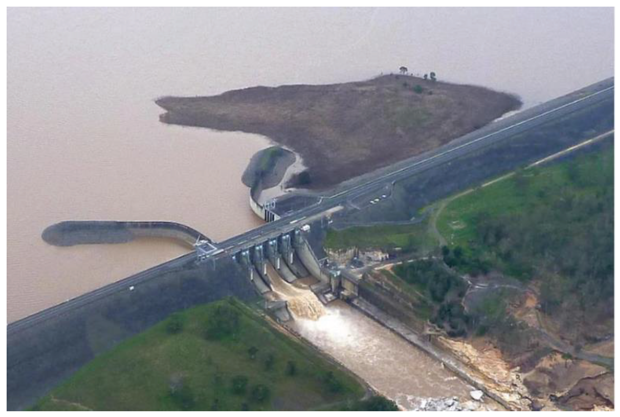
Figure 2.
Water storage capacity of major dams in Queensland-Australia (by 8th May 2022).
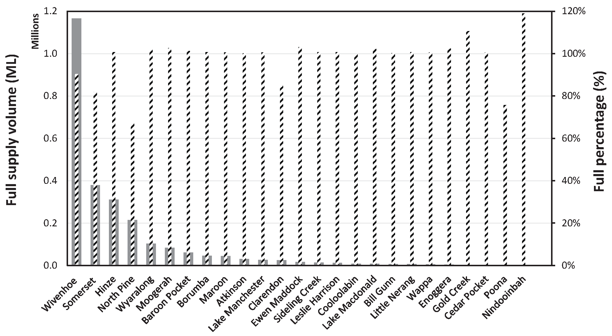
Figure 4.
Brisbane River through Linville to Wivenhoe dam.
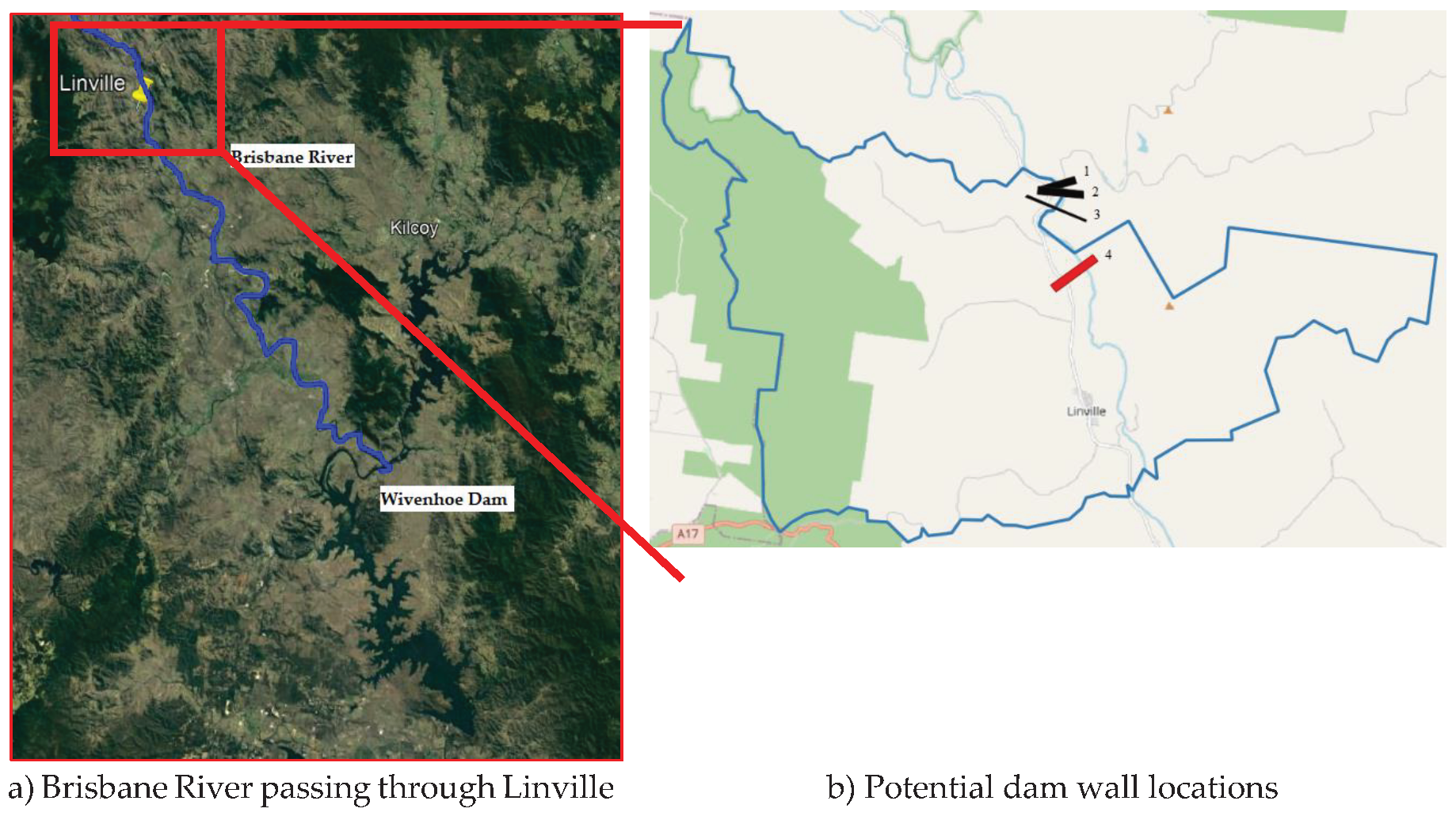
Figure 5.
The Upper Brisbane catchment.
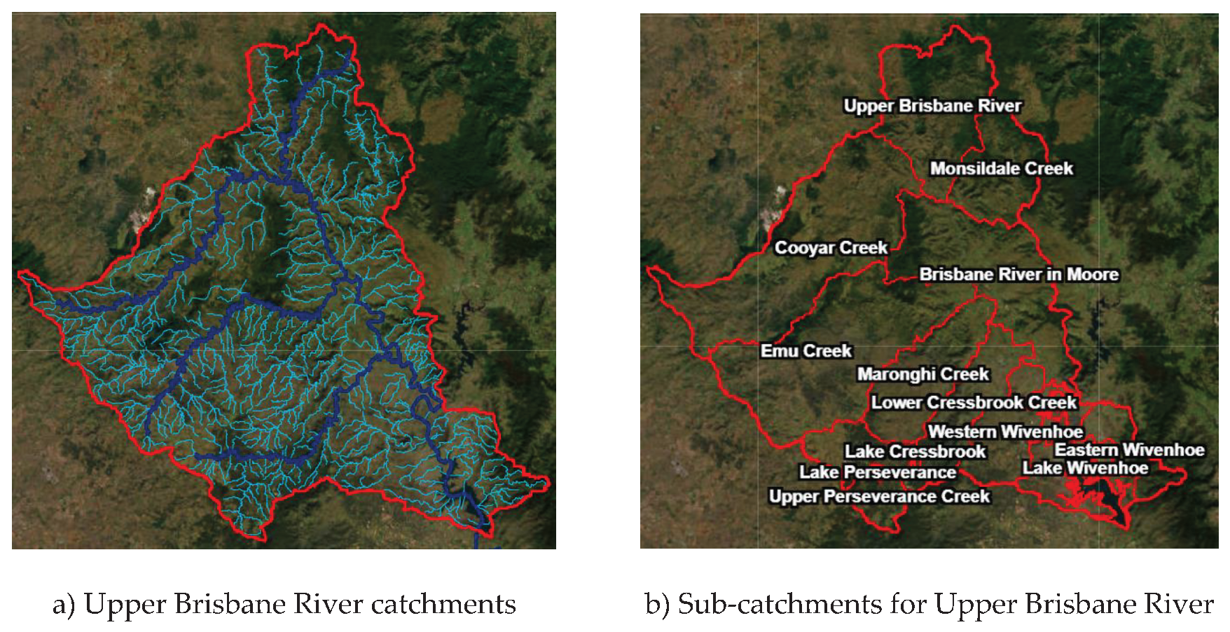
Figure 6.
DEM workflow process.
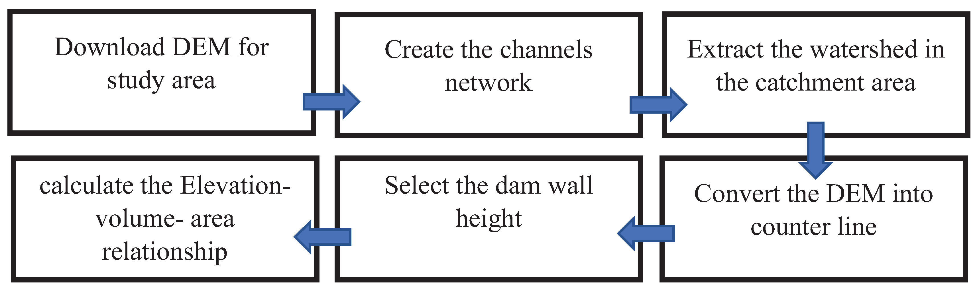
Figure 7.
Illustrations of proposed dam wall locations.
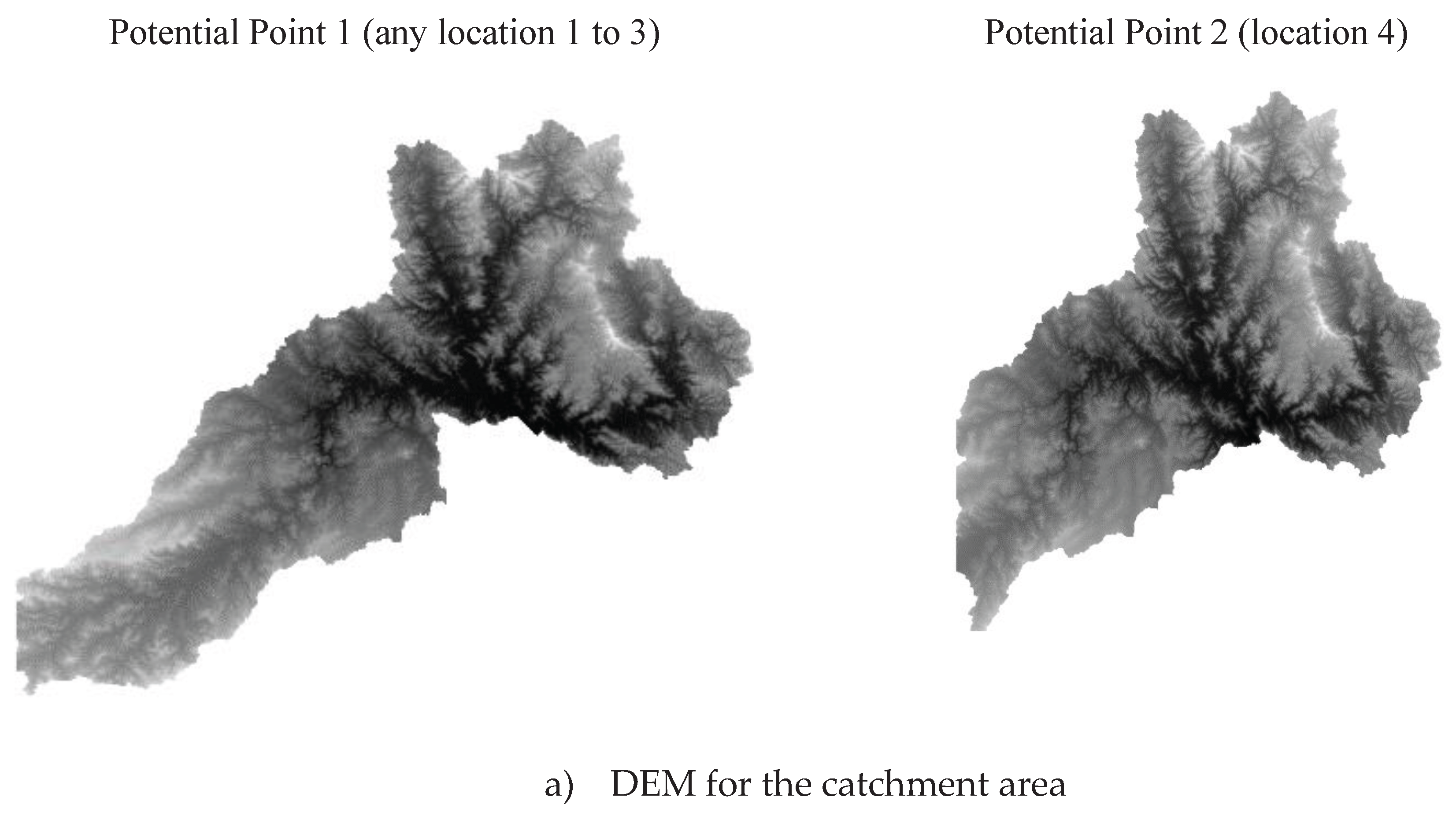
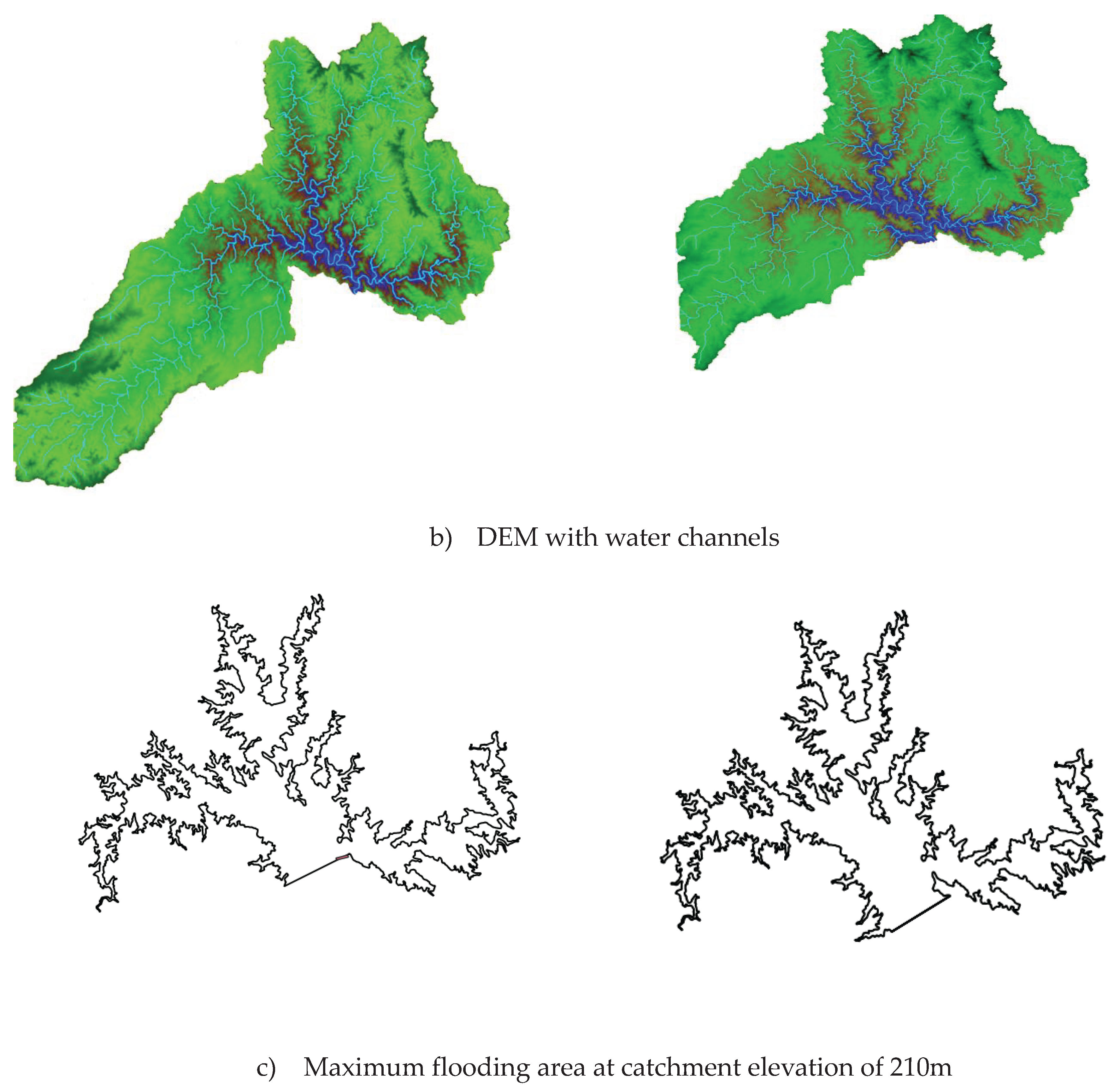
Figure 8.
Cross-section of the dam walls at the proposed locations.
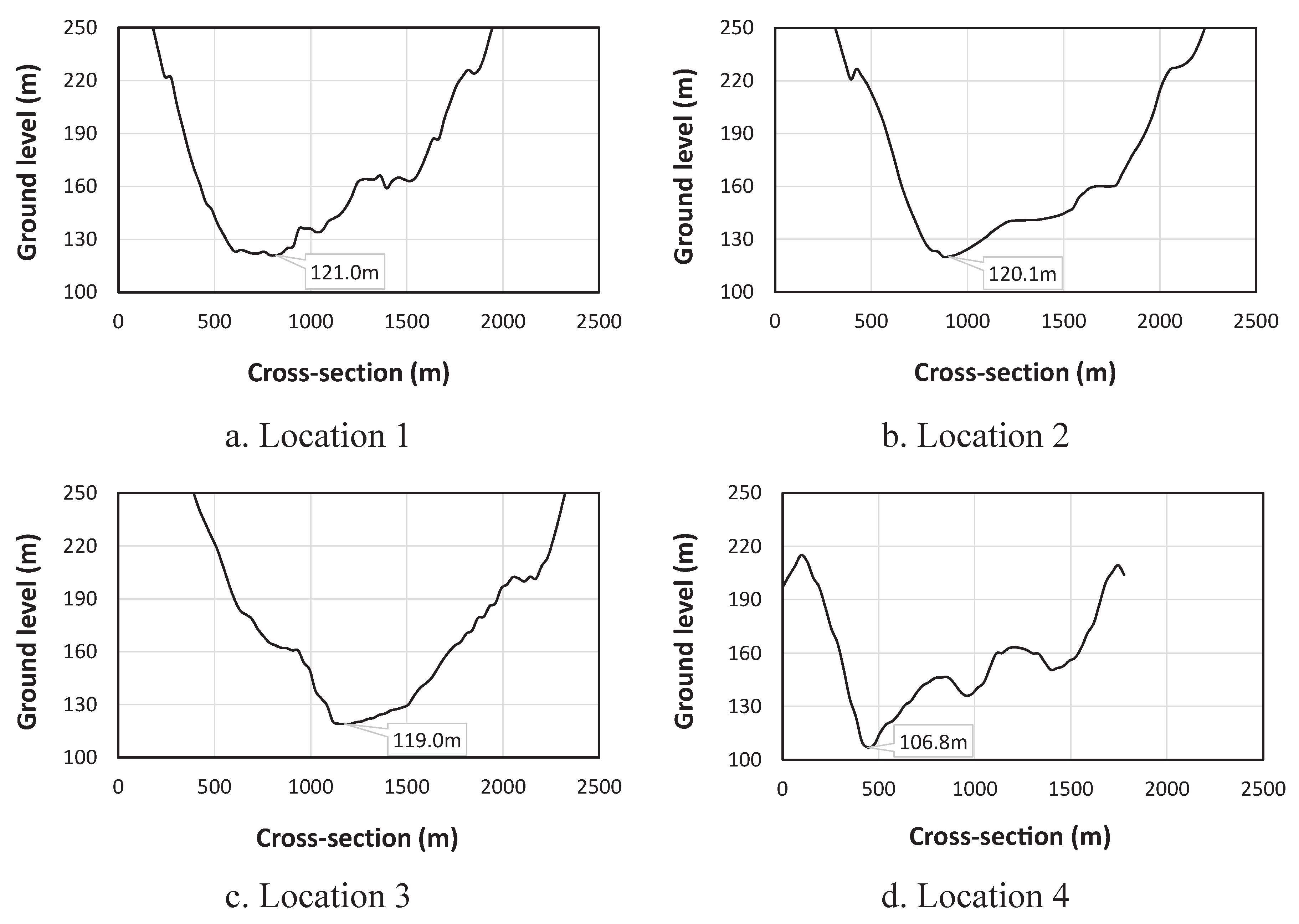
Figure 9.
Dam wall dimensions at locations 1 to 3.
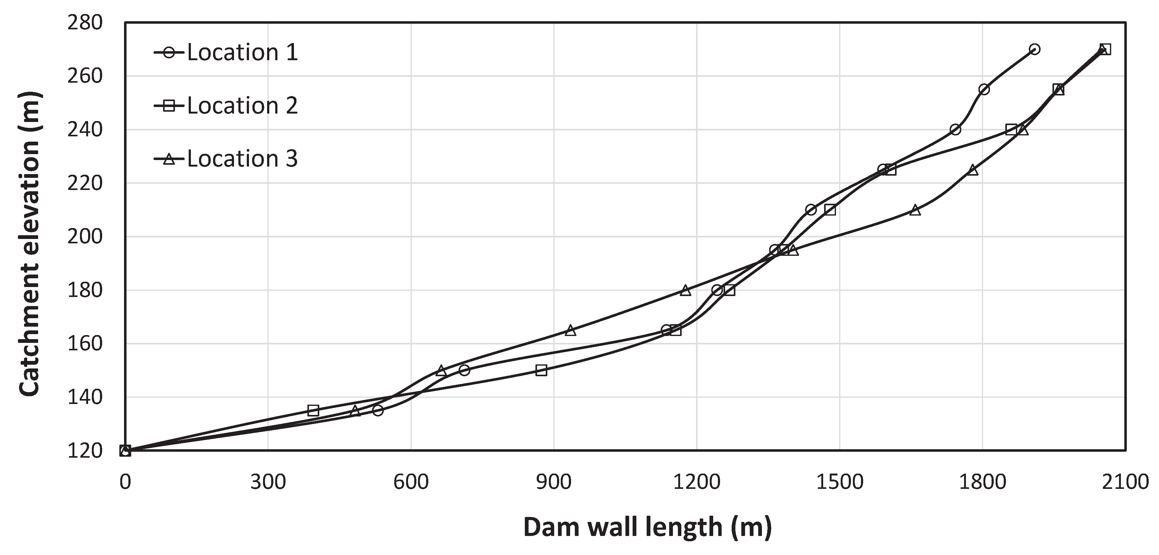
Figure 10.
Dam wall length and watershed properties at location 1.
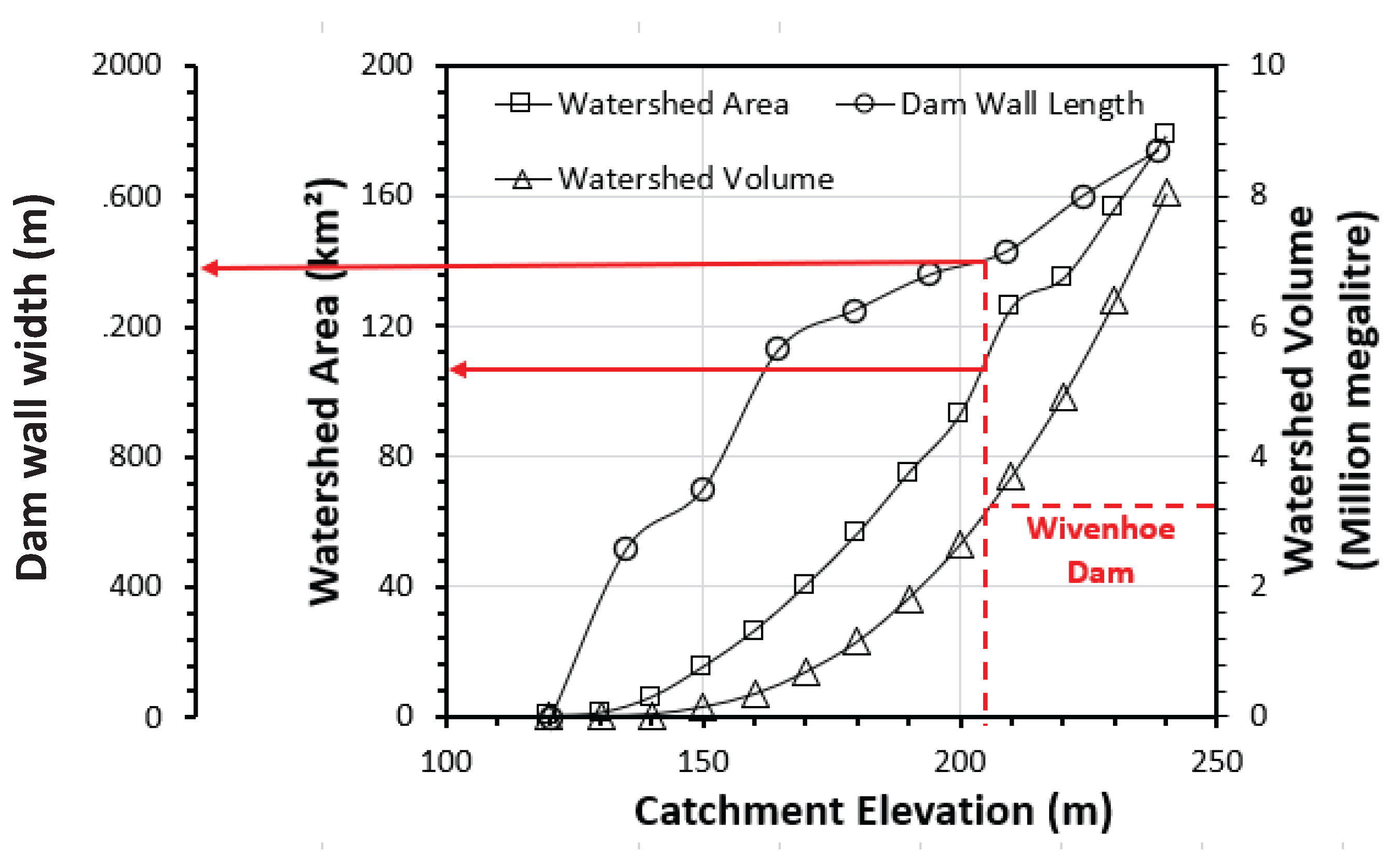

Table 1.
Catchment properties of the new supplementary dam at the potential points.
| Potential point 1 | Potential point 2 | |
|---|---|---|
| Ground level elevation (m) | 120.0±1.0 | 106.8 |
| Catchment elevation (m) | 270 | 210 |
| Catchment area (km2) | 1828 | 1586 |
| Maximum flooding area (km2) at 210 | 126.6 | 137.3 |
| Dam wall height (m) | 80.0±1.0 | 93.2 |
| Maximum flooding Volume (MML) at 210m | 3.67 | 4.32 |
| Volume-to-Area ratio (MML/ km2) | 0.0290 | 0.0315 |
Table 2.
Comparison between the proposed dam and Wivenhoe dam.
| Wivenhoe dam | Proposed dam | Same watershed volume | Same wall surface area | Same cost | |
|---|---|---|---|---|---|
| Catchment area (km2) | 7040 | 1828 | 1828 | 1828 | 1828 |
| Dam wall height (m) | 59 | 110 | 85 | 93 | 73 |
| Dam wall Length (m) | 2300 | 1630 | 1360 | 1460 | 1330 |
| Dam side area (m2) | 135700 | 179300 | 114750 | 135700 | 97090 |
| Watershed area (km2) | 110 | 137.3 | 106 | 131 | 82 |
| Watershed Volume (MML) | 3.132 | 6.383 | 3.132 | 3.750 | 2.230 |
| Volume-to-Area ratio (MML/km2) | 0.0282 | 0.0465 | 0.0295 | 0.0286 | 0.0272 |
| Dam wall construction cost ($M) | 272.1 | 584.8 | 347.6 | 420.0 | 272.1 |
| Volume-to-cost ratio (L/$) | 11510 | 10915 | 9010 | 8929 | 8196 |
Table 3.
Decision matrix for selecting the optimal dam wall size.
| Option 1 | Option 2 | Option 3 | Option 4 | |
| Watershed volume | √√ | √ | √ | × |
| Water harvesting efficiency | √√ | √ | √ | √ |
| Dam wall construction cost efficiency | √ | √ | √ | √ |
Disclaimer/Publisher’s Note: The statements, opinions and data contained in all publications are solely those of the individual author(s) and contributor(s) and not of MDPI and/or the editor(s). MDPI and/or the editor(s) disclaim responsibility for any injury to people or property resulting from any ideas, methods, instructions or products referred to in the content. |
© 2024 by the authors. Licensee MDPI, Basel, Switzerland. This article is an open access article distributed under the terms and conditions of the Creative Commons Attribution (CC BY) license (http://creativecommons.org/licenses/by/4.0/).
Copyright: This open access article is published under a Creative Commons CC BY 4.0 license, which permit the free download, distribution, and reuse, provided that the author and preprint are cited in any reuse.


