Submitted:
09 April 2024
Posted:
09 April 2024
You are already at the latest version
Abstract
Keywords:
1. Introduction
2. Materials and Methods
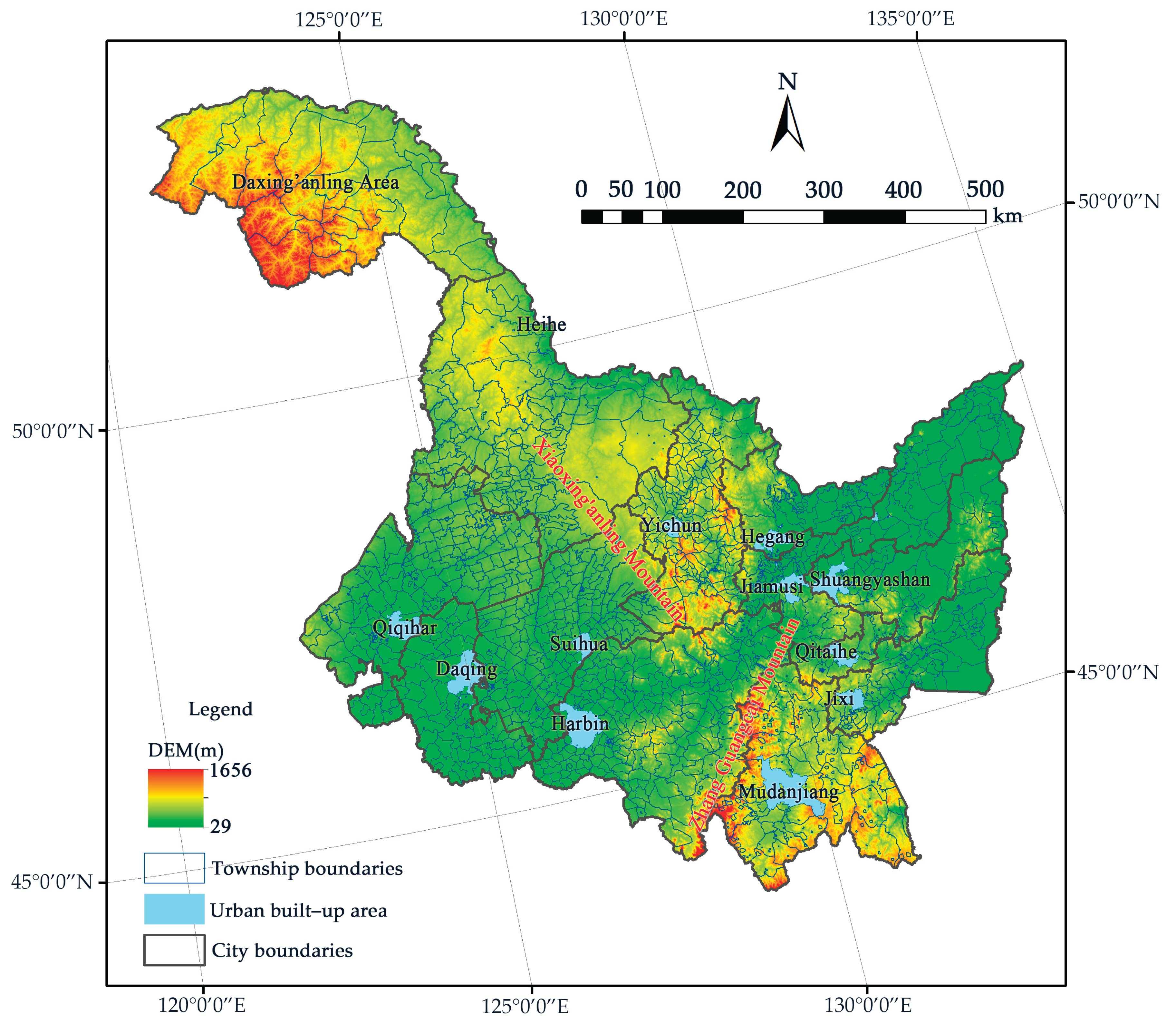
2.1. Study Area
2.2. Data Sources and Preprocessing
2.3. Methodology
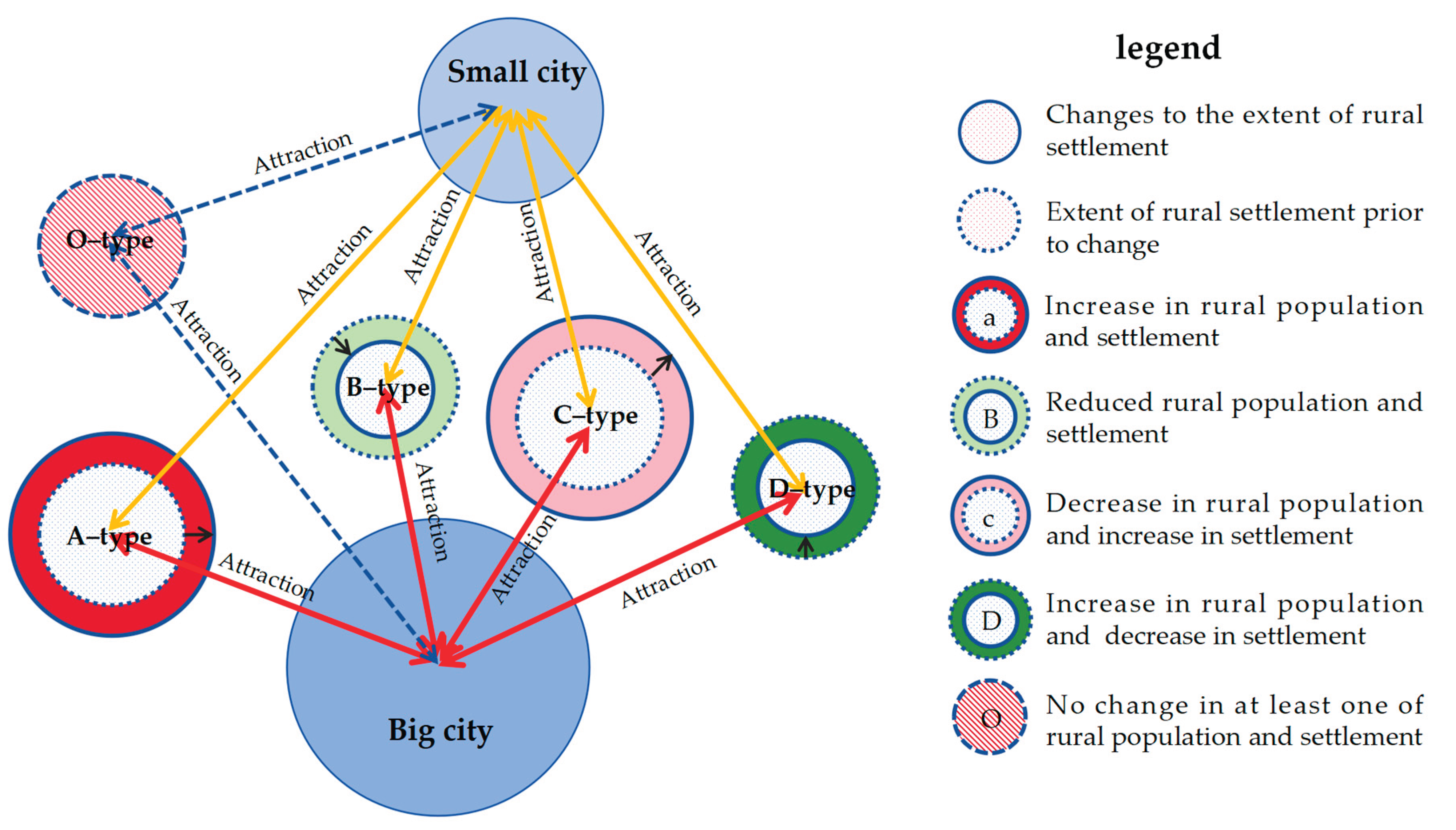
2.3.1. Patterns of Spatial and Temporal Changes in Population Size and Settlement Use in Rural Areas
2.3.2. Coupling of Population Mobility and Settlement Use in Rural Areas Degree Models
2.3.3. Modeling The Spatial Relationship between Urban and Rural Development
3. Results
3.1. Patterns of Spatial and Temporal Changes in Population Size and Settlement Use in Rural Areas
3.1.1. Spatial and Temporal Patterns of Population Change in Rural Areas
3.1.2. Spatial and Temporal Patterns of Settlements in Rural Areas
3.2. Characteristics of the Development of the Coupling of Population and Settlement Use in Rural Areas
3.3. The Spatial Patterns of Urban–Rural Development
3.3.1. Calculation of the Comprehensive Urban Attractiveness of the Study Area
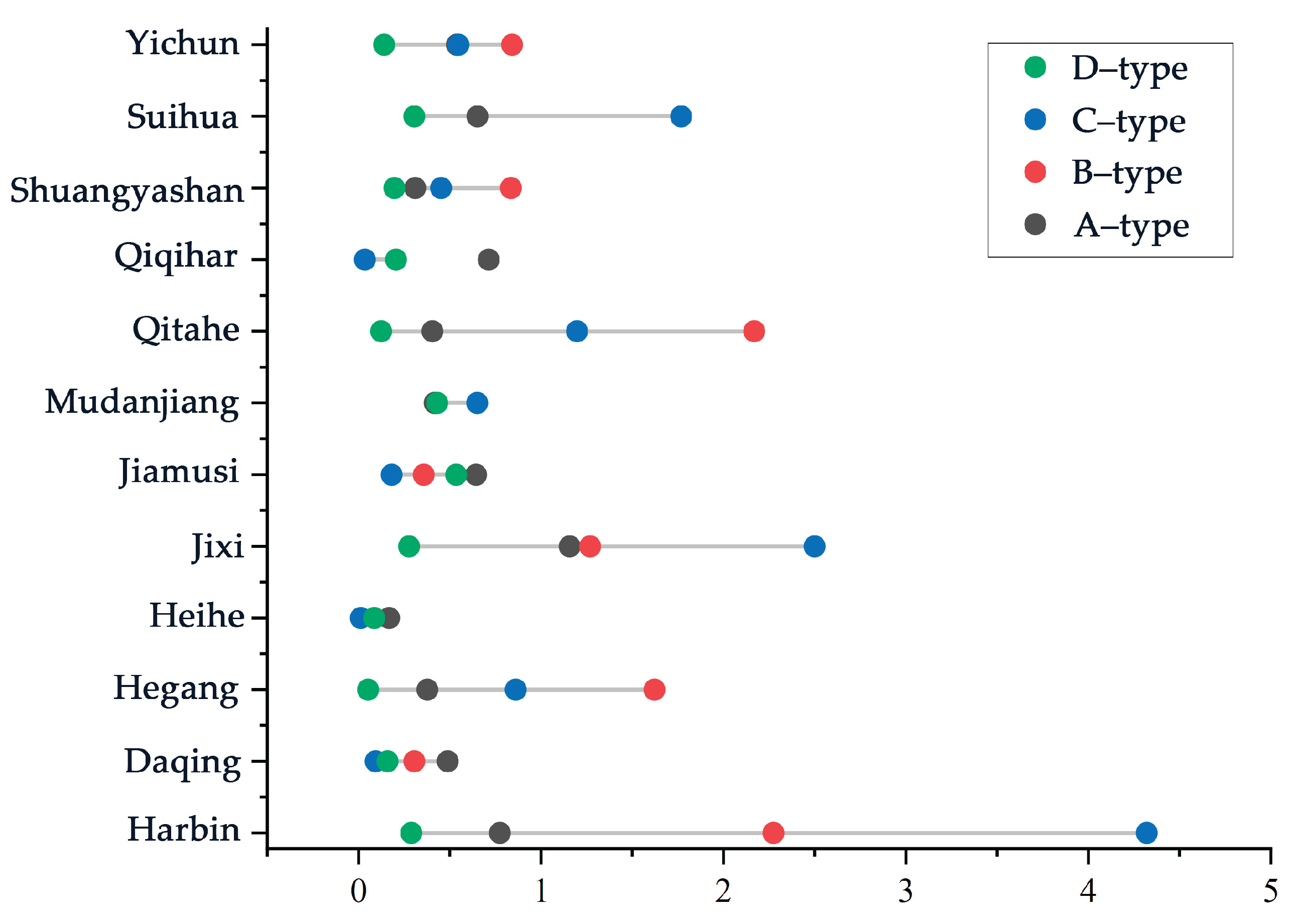
3.3.2. Calculation of Rural–Urban Development Forces in the Study Area
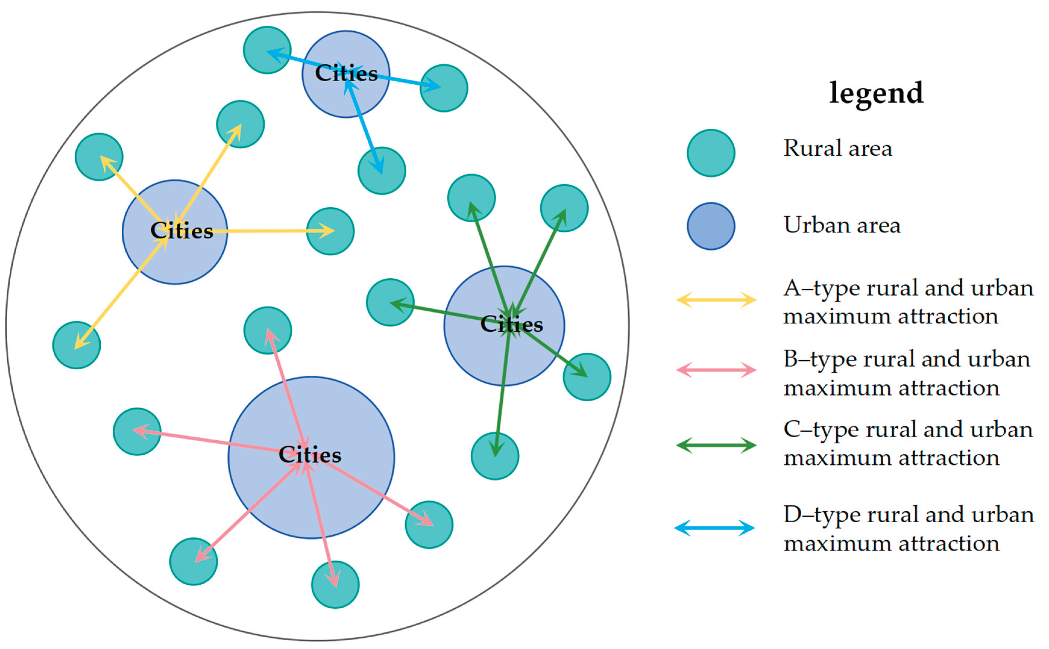
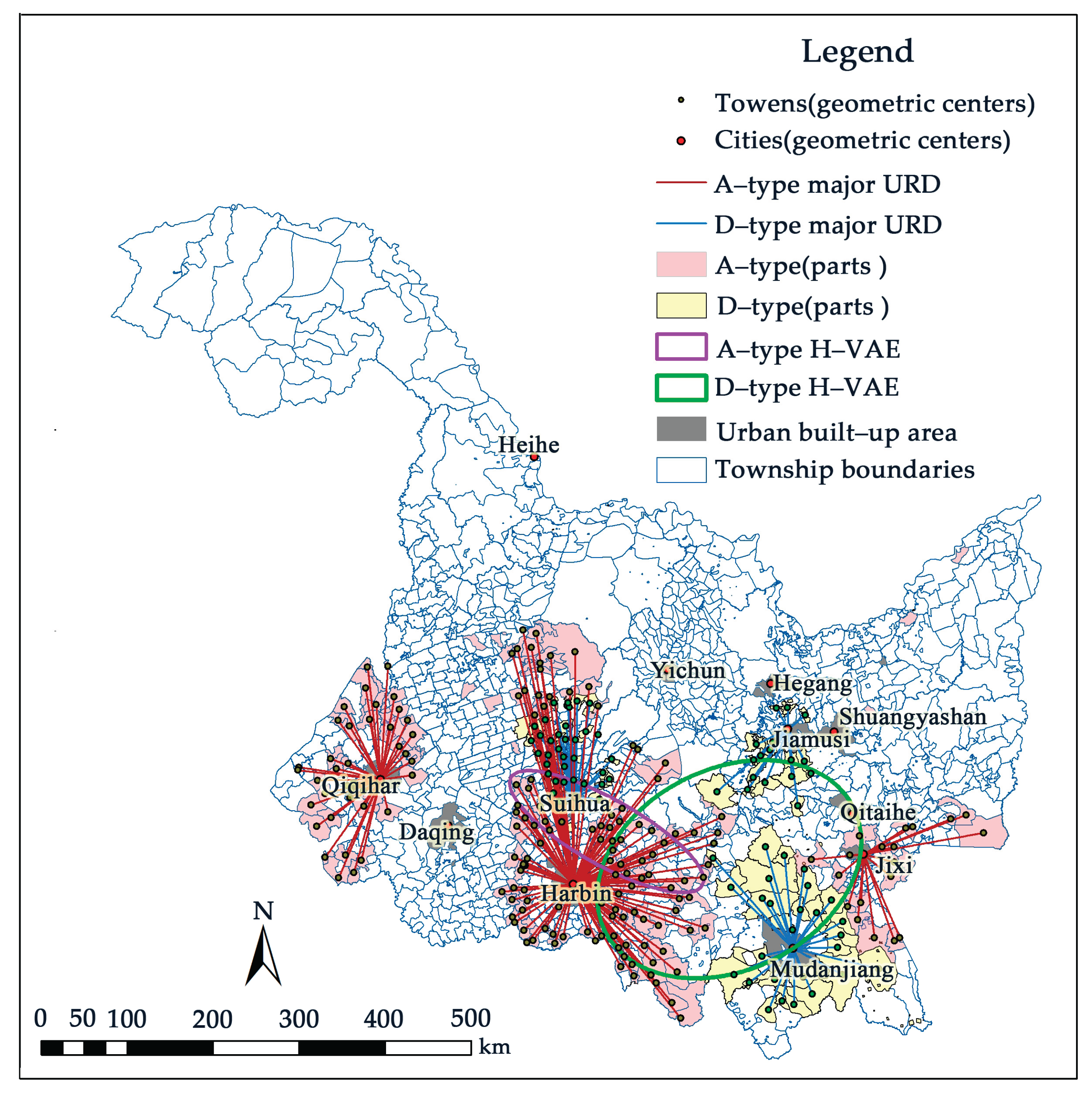
3.3.3. New Spatial Patterns of Urban–Rural Development Under the Urban–Rural Development Dynamic
4. Discussion
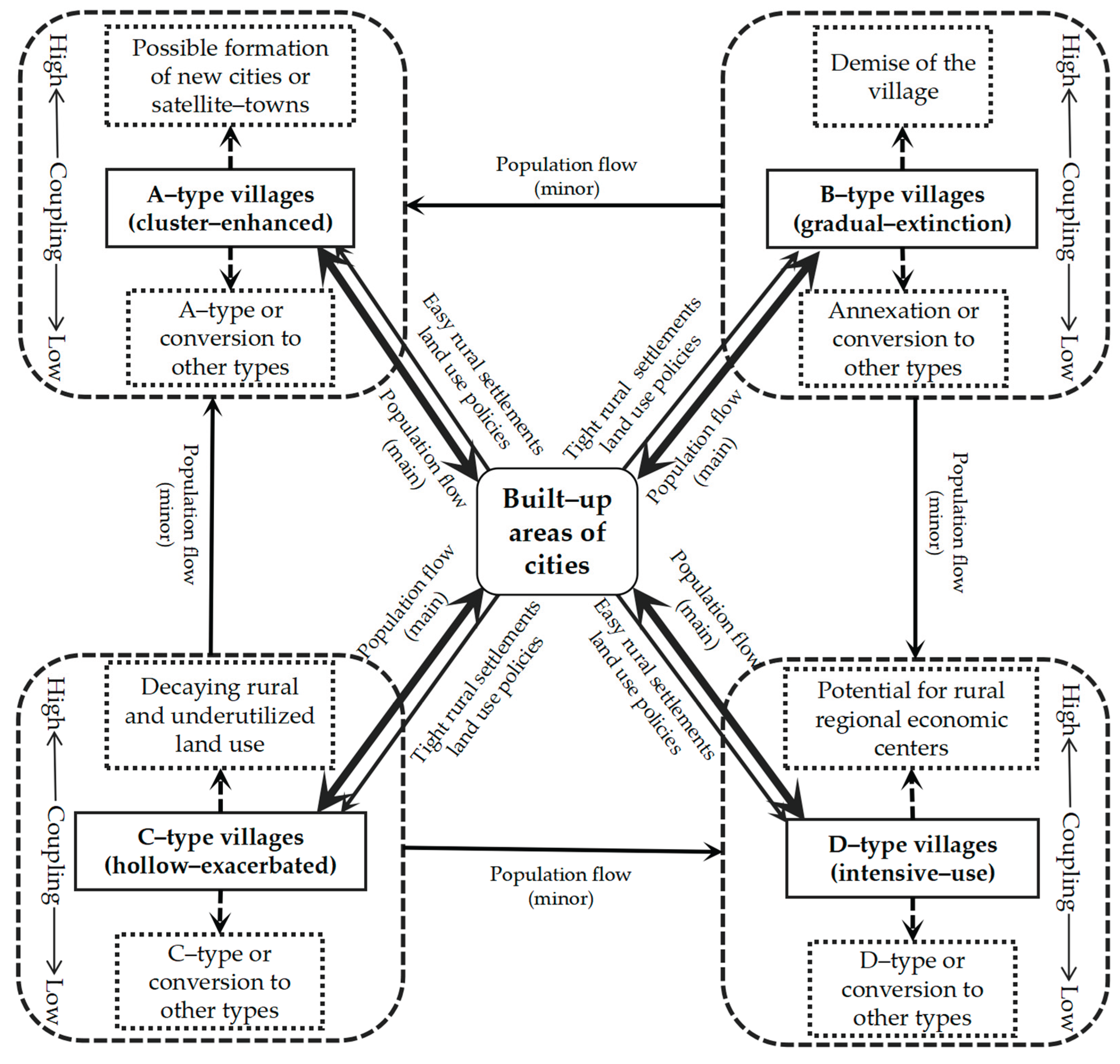
4.1. The Coupling of Rural Population and Settlement Use Reflects the Dynamic Development Trend of the Countryside
4.2. The New Spatial Pattern of Urban–Rural Development Favors Integrated Urban–Rural Development
4.3. Land–Use Policies Should Be Adjusted in Line with Urban–Rural Development Patterns
5. Conclusions
Author Contributions
Funding
Data Availability Statement
Conflicts of Interest
References
- Elshof, H.; Haartsen, T.; Van Wissen, L. J. G.; Mulder, C. H. The influence of village attractiveness on flows of movers in a declining rural region. Journal of Rural Studies 2017, 56, 39–52. [Google Scholar] [CrossRef]
- Wang, C.; Gao, B.; Weng, Z.; Tian, Y. Primary causes of total hamlet abandonment for different types of hamlets in remote mountain areas of China: a case study of Shouning county, Fujian province. Land Use Policy 2020, 95, 104627. [Google Scholar] [CrossRef]
- Yakubu, I. From a cluster of villages to a city: housing politics and the dilemmas of spatial planning in tamale, Ghana. Land Use Policy 2021, 109, 105668. [Google Scholar] [CrossRef]
- Yanan, L.; Smail, M. A.; Aminuddin, A. How has rural tourism influenced the sustainable development of traditional villages? A systematic literature review. Heliyon 2024, 10, e25627. [Google Scholar] [CrossRef]
- Liu, Y.; Lu, S.; Chen, Y. Spatio-temporal change of urbanerural equalized development patterns in China and its driving factors. Journal of Rural Studies 2013, 32, 320–330. [Google Scholar] [CrossRef]
- Liu, Y.; Zang, Y.; Yang, Y. China’s rural revitalization and development: Theory, technology and management. J. Geogr. Sci. 2020, 30, 1923–1942. [Google Scholar] [CrossRef]
- Serra, P.; Vera, A.; Tulla, A. F.; Luca Salvati, L. Beyond urban-rural dichotomy: exploring socioeconomic and land-use processes of change in Spain (1991-2011). Applied Geography, 2014, 55, 71–81. [Google Scholar] [CrossRef]
- Zhu, J.; Zhu, M.; Xiao, Y. Urbanization for rural development: Spatial paradigm shifts toward inclusive urban-rural integrated development in China. Journal of Rural Studies 2019, 71, 94–103. [Google Scholar] [CrossRef]
- Zhan, L.; Wang, S.; Xie, S.; Zhang, Q.; Qu, Y. Spatial path to achieve urban-rural integration development-analytical framework for coupling the linkage and coordination of urban-rural system functions. Habitat International 2023, 142, 102953. [Google Scholar] [CrossRef]
- Gu, H.; Ling, Y.; Shen, T.; Yang, L. How does rural homestead influence the hukou transfer intention of rural-urban migrants in China? Habitat International 2020, 105, 102267. [Google Scholar] [CrossRef]
- Cai1, E.; Chen, W.; Wei, H.; Li, J.; Wang, H.; Guo, Y.; Feng, X. The coupling characteristics of population and Settlements in rural areas of China and its implications for sustainable land use. Sustainable Development 2019, 1–11. [Google Scholar]
- Yang, Z.; Shen, N.; Qu, Y.; Zhang, B. Association between rural land use transition and urban-rural integration development: from 2009 to 2018 based on county-level data in Shandong province, China. Land 2021, 10, 1228. [Google Scholar] [CrossRef]
- Yang, Y.; Bao, W.; Wang, Y.; Liu, Y. Measurement of urban-rural integration level and its spatial differentiation in China in the new century. Habitat International 2021, 117, 102420. [Google Scholar] [CrossRef]
- Wang, M.; Yang, Y.; Guo, T. Measurement of urban-rural integration level in suburbs and exurbs of big cities based on land-use change in inland China: Chengdu. Land 2021, 10, 474. [Google Scholar] [CrossRef]
- Hu, Z.; Li, Y.; Long, H.; Kang, C. The evolution of China’s rural depopulation pattern and its influencing factors from 2000 to 2020. Applied Geography 2023, 159, 103089. [Google Scholar] [CrossRef]
- Juan R., C. Population imbalances in Europe. Urban concentration versus rural depopulation. Regional Science Policy & Practice 2023, 15, 713–716. [Google Scholar]
- Wang, D.; Zhu, Y.; Zhao, M.; Lv, Q. Multi-dimensional hollowing characteristics of traditional villages and its influence mechanism based on the micro-scale: a case study of Dongguan village in Suzhou, China. Land Use Policy 2021, 101, 105146. [Google Scholar] [CrossRef]
- Liu, J.; Zhang, X.; Lin, J.; Li, Y. Beyond government-led or community-based: Exploring the governance structure and operating models for reconstructing China’s hollowed villages. Journal of Rural Studies 2022, 93, 273–286. [Google Scholar] [CrossRef]
- Rao, J. Comprehensive land consolidation as a development policy for rural vitalisation: Rural in Situ urbanisation through semi socio-economic restructuring in Huai Town. Journal of Rural Studies 2022, 93, 386–397. [Google Scholar] [CrossRef]
- Chen, L.; Huang, Y.; Qin, X.; Xu, W.; Qin, Y.; Li, X. Return migration and in-situ urbanization of 79 migrant sending counties in China: Characteristic and driving factors. Journal of Rural Studies 2023, 104, 103155. [Google Scholar] [CrossRef]
- Li, J.; Lo, K.; Zhang, P.; Guo, M. Reclaiming small to fill large: A novel approach to rural Settlements consolidation in China. Land Use Policy 2021, 109, 105706. [Google Scholar] [CrossRef]
- Liua, L.; Gao, X.; Zhuang, J.; Wud, W.; Yange, B.; Cheng, W.; Xiao, P.; Yao, X.; Deng, O. Evaluating the lifestyle impact of China’s rural housing land consolidation with locational big data: A study of Chengdu. Land Use Policy 2020, 96, 104623. [Google Scholar] [CrossRef]
- Drobnjaković, M.; Steinführer, A. Re-thinking rurality: Towards a new research approach and rural-urban spatial gradient establishment in Serbia. Applied Geography 2024, 163, 103195. [Google Scholar] [CrossRef]
- Allawi, A. H.; Al-Jazaeri, H. M. J. A new approach towards the sustainability of urban-rural integration: the development strategy for central villages in the Abbasiya district of Iraq using gis techniques. Regional Sustainability 2023, 4, 28–43. [Google Scholar] [CrossRef]
- Pan, W.; Wang, J.; Li, Y.; Chen, S.; Lu, Z. Spatial pattern of urban-rural integration in China and the impact of Geography. Geography and Sustainability 2023, 4, 404–413. [Google Scholar] [CrossRef]
- Ma, M.; Jiang, L.; Qi, K. Investigating the urbanerural integrated town development strategy on the basis of the study of rural forms in Nantong, China. Frontiers of Architectural Research 2021, 10, 190–201. [Google Scholar] [CrossRef]
- Wang, Y.; Liu, Y.; Li, Y.; Li, T. The spatio-temporal patterns of urbanerural development transformation in China since 1990. Habitat International 2016, 53, 178–187. [Google Scholar] [CrossRef]
- Chen, Z.; Yu, S.; You, X.; Yang, C.; Wang, C.; Lin, J.; Wu, W.; Yu, B. New nighttime light landscape metrics for analyzing urban-rural differentiation in economic development at township: A case study of Fujian province, China. Applied Geography 2023, 150, 102841. [Google Scholar] [CrossRef]
- Liu, J.; Liu, Y.; Li, Y.; Hu, Y. Coupling analysis of rural Settlements and rural population in China during 2007-2015. Journal of Natural Resources 2018, 73, 1865–1879. [Google Scholar]
- Zhang, X.; Wang, J.; Song, W.; Wang, F.; Gao, X.; Liu, L.; Dong, K.; Yang, D. Decoupling Analysis between Rural Population Change and Rural Construction Land Changes in China. Land 2022, 11, 231. [Google Scholar] [CrossRef]
- Ministry of Agriculture and Rural Affairs of the People′s Republic of China. Available online: http://www.moa.gov.cn/xw/qg/202312/t20231212_6442624.htm (accessed on 12 December 2023).
- Guerri, G.; Crisci, A.; Congedo, L.; Munafò, M.; Morabito, M. A functional seasonal thermal hot-spot classification: Focus on industrial sites. Science of the Total Environment 2022, 806, 151383. [Google Scholar] [CrossRef] [PubMed]
- Lin, J.; Song, G.; Zhang, Y. Regionalization planning for prevention and control of saline-alkali land based on a landscape ecology risk pattern theory: A case study in Lindian County, Heilongjiang Province. Acta Ecologica Sinica 2018, 38, 5509–5518. [Google Scholar]
- Lin, J.; Song, G.; Song, S. M. Research on dynamic changes of landscape structure and land use eco-security: a case study of Jiansanjiang land reclamation area. Acta Ecologica Sinica. 2011, 31, 5918–5927. [Google Scholar]
- Lin, J.; Song, G. Research on dynamic changes of landscape structure and land use eco-security spatiotemporal variation in Jian Sanjiang land reclamation area. Research on Soil and Water Conservation 2016, 23, 48–54. [Google Scholar]
- Liu, S.; Ye, Y.; Lin, Y. Evolution characteristics and decomposition of driving factors on rural Settlements based on decoupling theory and LMDI mode. Transactions of the Chinese Society of Agricultural Engineering 2019, 35, 272–280. [Google Scholar]
- Guo, L.; Liu, Y.; Feng, J.; He, S. Spatial-temporal pattern of provincial new-type urbanisation and integrated urban-rural development in China and its influence factors. Journal of Earth Sciences and Environment 2023, 45, 781–795. [Google Scholar]
- Yang, Y.; Dong, S.; Li, F.; Cheng, H.; Chi, Y.; Li, Z.; Li, S.; Liu, Q.; Xia, B.; Li, Y. Interregional polarized and trickling-down effect of carbon emission space and the optimization policies: Case studies of the Jing-Jin-Ji region. Journal of Cleaner Production 2022, 370, 133426. [Google Scholar] [CrossRef]
- Hirschman, A. O. The strategy of economic development.; Publisher: Yale University Press, United States of America, 1958; pp. 5–26. [Google Scholar]

| Target Level | Normative Layer | Indicator Layer | Unit (of Measure) |
|---|---|---|---|
| Employment environment | Economic level | Gross regional product | CNY Millions/ 100 persons |
| Economically dense | CNY Millions / 100 hectares |
||
| Employment level | Unemployment rate in urban area | % | |
| Number employed in urban non-private units | Person | ||
| Pay level | Average wage of employed persons in Urban Non-Private Units | RMB/CNY | |
| Average wage of employed persons in urban private units | RMB/CNY | ||
| Environment | Consumption level | Urban annual per capita disposable income of urban households | RMB/CNY |
| Housing level | Total assets of real estate | CNY Ten thousands | |
| Total sale of commercialized buildings | CNY Ten thousands | ||
| Public transport | Total road area per capita | m/person | |
| Number of public vehicles under operation | Unit | ||
| Length under operation | Km | ||
| Public service facilities | Enrollment of compulsory education | % | |
| Number of institutions and public cultural facilities | Unit | ||
| Number of hospitals | Unit | ||
| Ecological environment | Ecological status | Area of parks and green land | Km2 |
| Water resources per capita | Million m3 / 100 persons |
||
| Emissions volume of air contaminants (sulfur dioxide, nitrogen oxide, smoke and dust) | Ton | ||
| Volume of waste water discharged | Ten thousand tons |
| City Name | Harbin | Qiqihar | Jixi | Hegang | Shuangyashan | Daqing |
| Total Value | 0.7498 | 0.3050 | 0.2431 | 0.2326 | 0.2260 | 0.5812 |
| City Name | Yichun | Jiamusi | Qitaihe | Mudanjiang | Heihe | Suihua |
| Total Value | 0.1726 | 0.2646 | 0.2493 | 0.3204 | 0.2440 | 0.2128 |
| B–Type Township Name | B–Type City Name |
B–RUD | C–Type Township Name | C–Type City Name |
C–RUD |
|---|---|---|---|---|---|
| 855 Farm | Qitaihe | 0.7891 | Eight Town | Harbin | 0.3546 |
| Beixing Farm | Qitaihe | 1.3187 | Erba Town | Harbin | 0.8999 |
| Hongwei Town | Qitaihe | 0.0000 | Just Street | Harbin | 0.8330 |
| Yulin Town | Harbin | 1.5273 | Hulan Nongken | Harbin | 0.4142 |
| Daiyun Town | Harbin | 1.3718 | Kangjin Street | Harbin | 0.3168 |
| Jiehe Township | Qitaihe | 6.5657 | Lanhe Street | Harbin | 5.5750 |
| Yanglin Township | Harbin | 1.0768 | Shiren Town | Harbin | 0.9549 |
| Waibu Street | Harbin | 6.2688 | Yanjiagang Farm | Harbin | 0.3152 |
| Yongsheng Township | Harbin | 1.1267 | Changchunling Town | Harbin | 0.1283 |
| Pair of Qingshan Town | Harbin | 2.8515 | |||
| Fangtai Township | Harbin | 1.3862 | |||
| Hulan street | Harbin | 1.8028 | |||
| Construction Road Street | Harbin | 7.5187 | |||
| Mengjia Town | Harbin | 2.1639 | |||
| Youth farm | Harbin | 5.6085 | |||
| Shenjia Town | Harbin | 2.6981 | |||
| Shuangjing Street | Harbin | 3.3648 | |||
| Xu Bu Township | Harbin | 1.1773 | |||
| Changling Township | Harbin | 2.6751 |
Disclaimer/Publisher’s Note: The statements, opinions and data contained in all publications are solely those of the individual author(s) and contributor(s) and not of MDPI and/or the editor(s). MDPI and/or the editor(s) disclaim responsibility for any injury to people or property resulting from any ideas, methods, instructions or products referred to in the content. |
© 2024 by the authors. Licensee MDPI, Basel, Switzerland. This article is an open access article distributed under the terms and conditions of the Creative Commons Attribution (CC BY) license (http://creativecommons.org/licenses/by/4.0/).


