1. Introduction
The relocation of Indonesia’s capital to IKN (Ibukota Negara) Nusantara represents a monumental initiative undertaken by the Indonesian government to transfer the governmental center from Jakarta to East Kalimantan. This project was initiated in response to various challenges faced by Jakarta, including extreme population density, pollution, and high risks of natural disasters. Moreover, this capital relocation is anticipated to facilitate a more equitable distribution of economic growth across Indonesia, reducing regional disparities and stimulating infrastructure development and investment in the new area (Syaban & Appiah-Opoku, 2023). However, the transition to IKN Nusantara is full of challenges. One significant impact of this project is the extensive land use change near the new IKN location. Lands previously utilized for agriculture, conservation, or as natural habitats will transform the construction of infrastructure, residential zones, and government facilities. Such changes will inevitably affect various aspects, including the socio-economic conditions of the local communities, the availability of natural resources, and the ecological balance, necessitating meticulous planning and management to avert negative impacts. The relocation of the capital to IKN Nusantara and the accompanying land use changes engender the potential for multidimensional conflicts. Conflicts may arise from various aspects, such as local community objections to land acquisition, concerns over environmental degradation, and competition over resources. To address these potential conflicts, an inclusive and sustainable approach that considers the interests of all stakeholders is required. The capital relocation must be implemented with a long-term vision that focuses on physical development, social development, and environmental conservation (Dwi Djayanti et al., 2022).
Land use change is a critical aspect in the development process of the Nusantara Capital City Area (IKN), involving a significant transformation from the original use of land, predominantly forests, and agricultural fields, to urban infrastructure such as government buildings, residential complexes, and various other support facilities. This transformation not only alters the landscape and physical structure of the area but also has widespread impacts on the local setting’s social, economic, and environmental aspects. The conversion of land serves as a crucial step in establishing the physical foundation of the new IKN, which is intended to support governmental functions and the social life of its community. Within the context of IKN Nusantara, this change in land use is expected to drive economic growth and infrastructure development in East Kalimantan while alleviating the burden on Jakarta as the country’s administrative center. However, converting from natural and agricultural areas to urban zones requires careful planning and a sensitive approach to local issues. This is essential to minimize negative impacts, such as loss of natural habitats, reduced agricultural areas that could affect local food security, and disruption to local hydrological systems. Therefore, an integrated approach involving relevant stakeholders, including local communities, government, and the private sector, is crucial (Afrizal & Berenschot, 2020; Kolers, 2009). The land use change process also discusses how sustainable development can be integrated into large-scale projects such as the IKN development. This includes the application of environmentally friendly design principles, biodiversity conservation, and responsible management of natural and social resources. Awareness of the importance of maintaining a balance between development and conservation is critical to ensuring that land use transformation meets current needs and considers environmental sustainability and the well-being of future generations. Through a thoughtful and collaborative approach, land use change in IKN Nusantara can serve as a model for sustainable and inclusive new city development.
Land use changes in the vicinity of the IKN Nusantara area have precipitated significant social conflicts, directly impacting the lives of the local populace. The acquisition of land for development often entails disposing of local communities from lands that have been sources of livelihood, access to natural resources, and disconnection from ancestral cultural heritages. This loss engenders deep-seated grievances, sparking resistance against the government and investors. Such conflicts can escalate into broader social issues, disrupting development processes and leading to social instability if not managed with inclusive and equitable policies. Economic conflicts also emerge as a critical dimension of land use changes. Competition for resources and compensation perceived as inadequate by the local communities fosters feelings of injustice and marginalization. While the development of IKN is anticipated to bring prosperity, disparities in the distribution of benefits and employment opportunities often provoke tensions. There needs to be more transparency and community participation in the development process; these economic conflicts can obstruct sustainable and inclusive development objectives, creating divides between beneficiaries and those disadvantaged by the project. Environmental conflict represents another critical aspect arising from land use changes. The construction of infrastructure and new settlements in the IKN area threatens nature conservation and biodiversity, damaging ecosystem services that have supported the lives and livelihoods of communities. These conflicts stem from the dichotomy between the necessity for economic development and the imperative to preserve environmental sustainability. Without a balanced approach that prioritizes sustainable development and community involvement in natural resource management, environmental conflicts may complicate the achievement of development goals that are harmonious with nature. This necessitates a nuanced understanding and strategic management of the multi-faceted conflicts induced by land use transformations, ensuring that development initiatives like IKN Nusantara do not merely advance economic objectives but also address social equity and environmental stewardship (Fanselow, 2014; Setyo Prihatin et al., 2019; Sunarno, 2019).
This research endeavors to comprehend and analyze potential conflicts arising from land use changes within the IKN Nusantara area. Such analysis is crucial for identifying solutions that can accommodate the interests of various stakeholders, mitigate potential conflicts, and ensure that the development of IKN proceeds inclusively and sustainably. The research aims to provide evidence-based policy recommendations for managing multidimensional conflicts and maximizing the benefits of the IKN Nusantara development for all parties involved.
2. Literature Review
Land use is an intricate aspect of resource allocation that involves the equitable distribution of land resources among various functions, such as agriculture, housing, industry, and conservation, with the primary objective of maximizing benefits for humanity while minimizing negative impacts on the environment (Turner II et al., 2007). Many factors influence land use and management, including socioeconomics, technology, policy, environmental change, and demographics. These factors drive changes in land use patterns over time, leading to land conversion, urban expansion, and ecosystem restoration. Governments, the private sector, and local communities are responsible for making decisions that result in land use changes, which are influenced by economic needs, government policies, climate change, and technological advances. These factors demonstrate complex interactions between human aspirations and natural resource limits. Therefore, an integrated and sustainable approach must address land use management’s social, economic, and environmental aspects. This approach should protect ecologically sensitive areas, promote sustainable agricultural development, and improve urban land use efficiency to balance the development and preservation of natural resources and the environment (Lambin & Meyfroidt, 2011).
The impact of economic globalization and shrinking productive land on land use change has been a significant concern. Efforts to conserve forests and increase food production sometimes conflict with global needs for agricultural land. Identifying replacement, rebound, cascade, and remittance effects in the context of economic globalization highlights the need to view land use change as part of an open system that interacts with global scale factors, including international trade, technological progress, and migration (Seto et al., 2010). Contemporary urbanization, characterized by the expansion of urban land involving the conversion of agricultural land into residential and industrial areas, has fundamentally changed the relationship between cities and the global environment. Innovative energy, transport, and infrastructure management approaches in urban areas that agglomerate population and economic activity can help reduce cities’ carbon footprint and improve urban quality of life. Therefore, understanding land use dynamics is critical in planning future green and sustainable cities (Fan et al., 2022; Ustaoglu & Williams, 2023).
(Galtung, 1996) delineates conflict as an intrinsic aspect of social interaction, harboring the potential for positive development. The emphasis is on identifying the root causes and dynamics influencing conflicts, transforming conflict into constructive interaction through mediation and diplomacy, culminating in sustained peace and social justice. Conflict is perceived as a broad spectrum, necessitating a diverse array of resolution approaches, including the involvement of third parties in the mediation process (Firman, 2000; Hall et al., 2011; Miall et al., 2005). Social and economic conflicts in Indonesia often stem from exclusive land management issues, inciting injustice against local communities due to agribusiness practices and infrastructure development without adequate compensation or relocation. Irresponsible natural resource exploration adds complexity to conflicts, damaging ecosystems and threatening environmental sustainability, as reflected in the expansion of palm oil plantations that provoke multidimensional conflicts among indigenous communities, corporations, and the government (Colchester, 2010). Economic crises and policy orientations favoring massive investments without considering the needs of local communities exacerbate the situation. Scott (1985) reveals that social conflict can also arise from elite manipulation of land to the detriment of farmer groups, who often respond through forms of resistance, both actively and passively. The economic adaptations farmers undertake, such as livelihood diversification, serve as evidence of resistance against economic dominance by the elite. This situation highlights the importance of integrating social justice with environmental conservation to address conflicts.
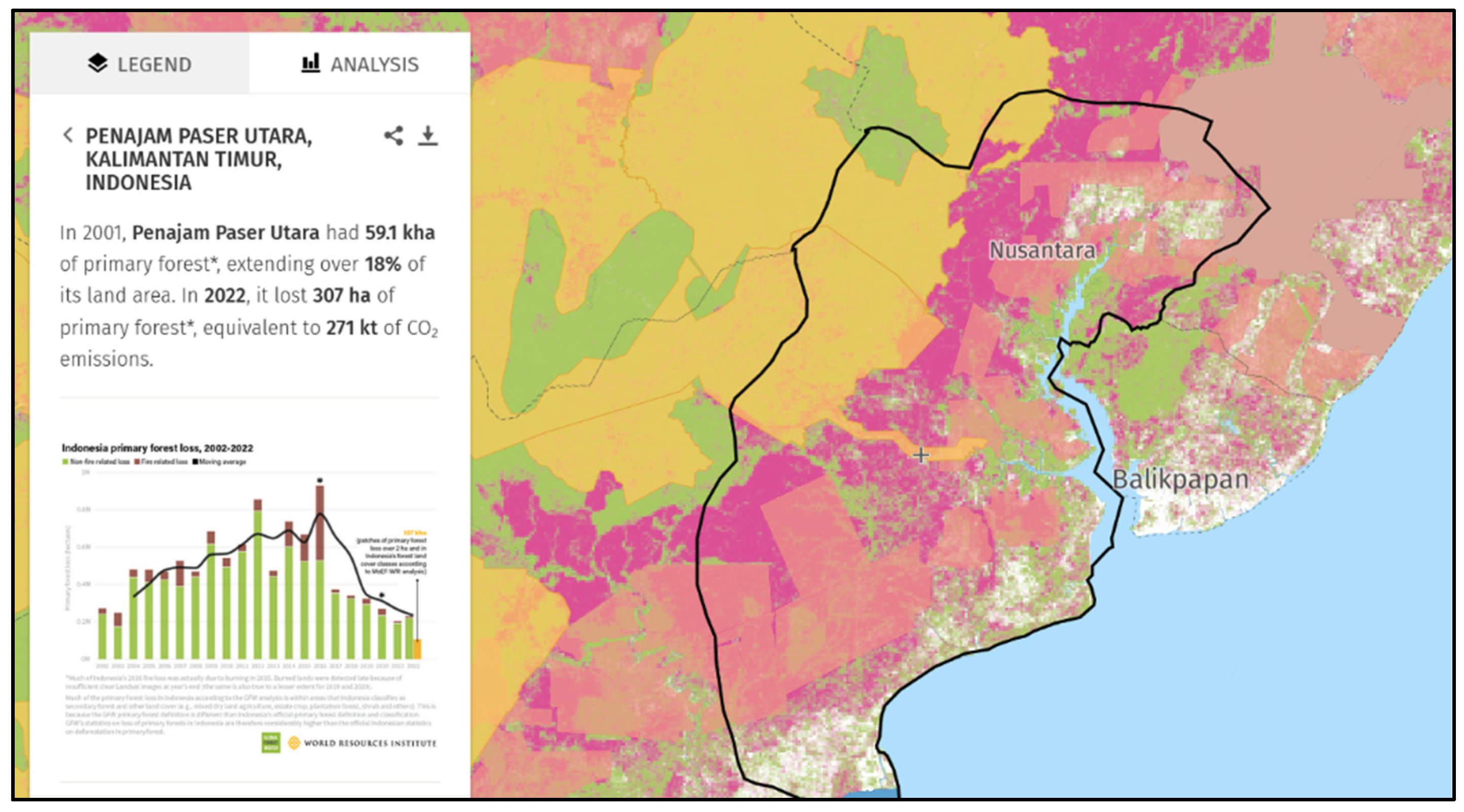
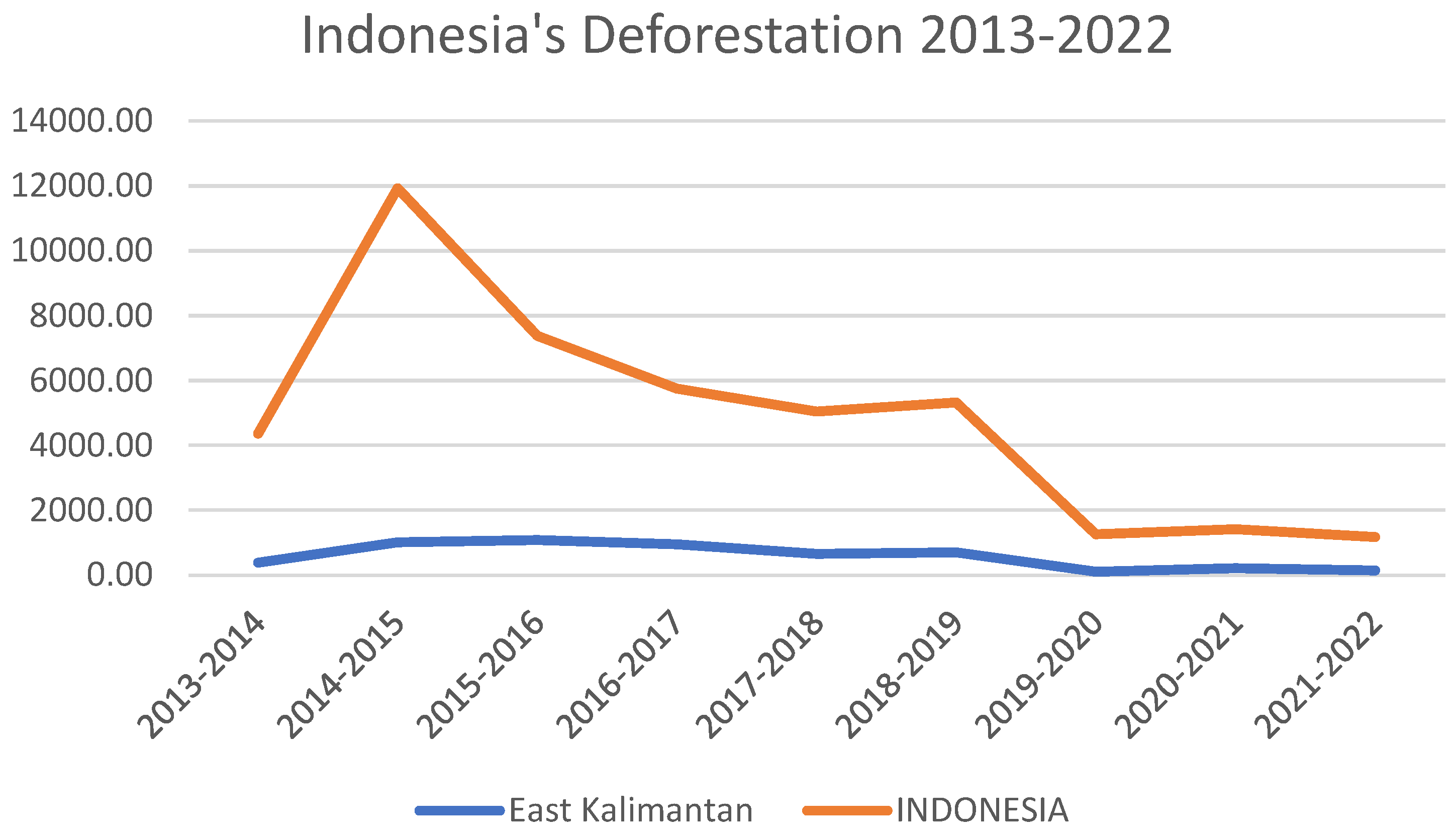
Over the last decade, land use changes in East Kalimantan have varied greatly, with deforestation rates initially at approximately 383,394 km², peaking at 1,086.82 km², and then decreasing to 137,588 km² by 2021-2022, likely reflecting the success of conservation efforts and environmental protections. The construction of IKN in this area underscores the need for sustainable practices due to its significant potential environmental impacts, highlighted by the recent deforestation trends and the necessity for careful land management (BPS, 2024; Teo et al., 2020). The selection of IKN’s location is strategic for spurring economic growth outside Java and shifting Indonesia’s geographic focus. However, careful consideration of Kalimantan’s environmental importance is also required, as the area is crucial for biodiversity and carbon sequestration. Ensuring sustainability in regional planning and involving local communities is essential to mitigate social tensions between newcomers and indigenous peoples (Farida, 2021). The increase in deforestation in North Penajam Paser Regency, the site of IKN Nusantara, underscores the need for development that harmonizes economic ambitions with environmental preservation and biodiversity. Development strategies should integrate economic expansion with ecological stewardship, including sustainable forestry, land rehabilitation, and responsible agroforestry while respecting local social and cultural norms to foster a culturally rich and developed urban environment.
Extensive land use change can precipitate social and economic conflicts rooted in inequitable resource distribution and irresponsible environmental management. The redirection of land for agribusiness or infrastructure development often overlooks the rights and needs of local communities, leading to injustices and conflicts between indigenous populations, corporations, and governments (Magsi et al., 2017). A pertinent example is observed in East Kalimantan, where significant land use alterations, including rampant deforestation and the development of the IKN Nusantara, underscore the importance of sustainable development practices and responsible land management to mitigate environmental impacts and prevent conflicts. An integrated approach, which considers social justice and environmental conservation, is essential in addressing the conflict dynamics associated with land use changes. Ensuring the involvement of local communities in planning and decision-making processes, along with promoting fair and sustainable resource management, can aid in averting tensions and establishing enduring peace and social justice.
4. Findings
4.1. Land Use Change and Environmental Conflict
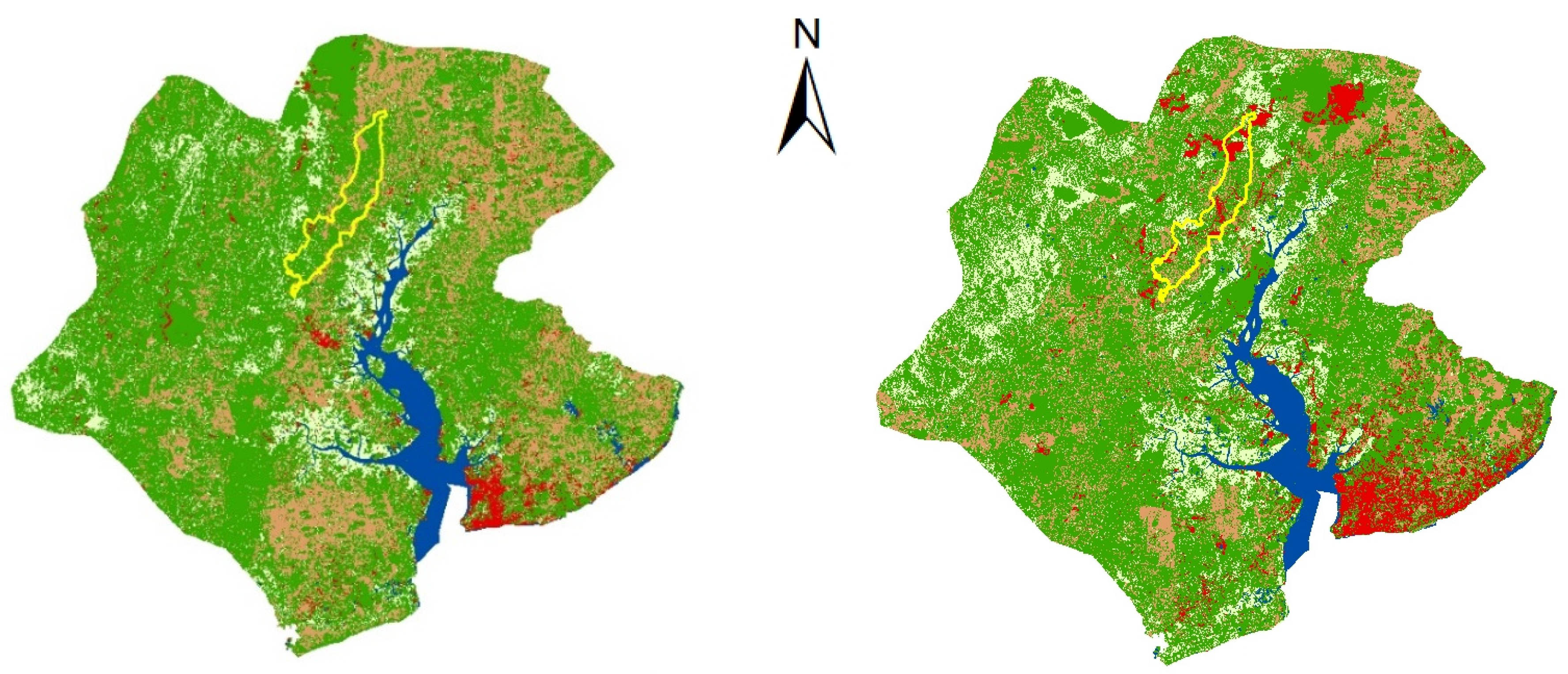
In 2003, before the establishment of IKN Nusantara, land use patterns were significantly influenced by the presence of natural vegetation, with a widespread vegetation cover extending to 1769.05 km². This area encompassed tropical rainforests, lowland forests, production forests, and other green open spaces, which serve as critical indicators of biodiversity and act as native habitats for various species of flora and fauna. Agricultural land covered an area of 569.56 km², playing a pivotal role in the local economy. This land served as a source of livelihood for the local population and supported food needs, both for domestic consumption and as part of agricultural commodity production. Additionally, wetlands were covering 290.52 km². Wetlands represent ecosystems rich in biodiversity and function as essential buffering systems, contributing to air quality regulation and flood mitigation and serving as breeding and development grounds for aquatic species. Bodies of water, encompassing 125.76 km², indicated the presence of rivers, lakes, or reservoirs vital in providing clean water, air transportation routes, and sources of fishing activities. Meanwhile, the developed land area occupied 86.63 km², indicating that 2003 infrastructure development and urban growth were limited. This may reflect a cautious approach to urbanization and infrastructure development, prioritizing the preservation of nature and sustainable land use.
Figure 2.
LULC in IKN Nusantara Area 2003 and 2023; Source: Author (2024).
Figure 2.
LULC in IKN Nusantara Area 2003 and 2023; Source: Author (2024).
In 2023, the utilization of land for vegetation purposes was recorded at approximately 1712.467 square kilometers, encompassing areas primarily consisting of forests or other green open spaces. Agricultural land covers an area of 436.105 square kilometers, indicating that the agricultural sector continues to contribute to the local economy. Wetlands spanned a significant area as well, totaling 396.500 square kilometers. This expanse suggests the presence of crucial ecosystems such as swamps, mangroves, or peatlands that are vital for air quality conservation and biodiversity and act as natural buffers against disasters like floods. Meanwhile, bodies of water covering an area of 125.038 square kilometers represent areas with rivers, lakes, or reservoirs that play a critical role in providing clean water sources and serving as a means for transportation and recreation. Furthermore, the built-up area reached 171.354 square kilometers, illustrating the urbanization process.
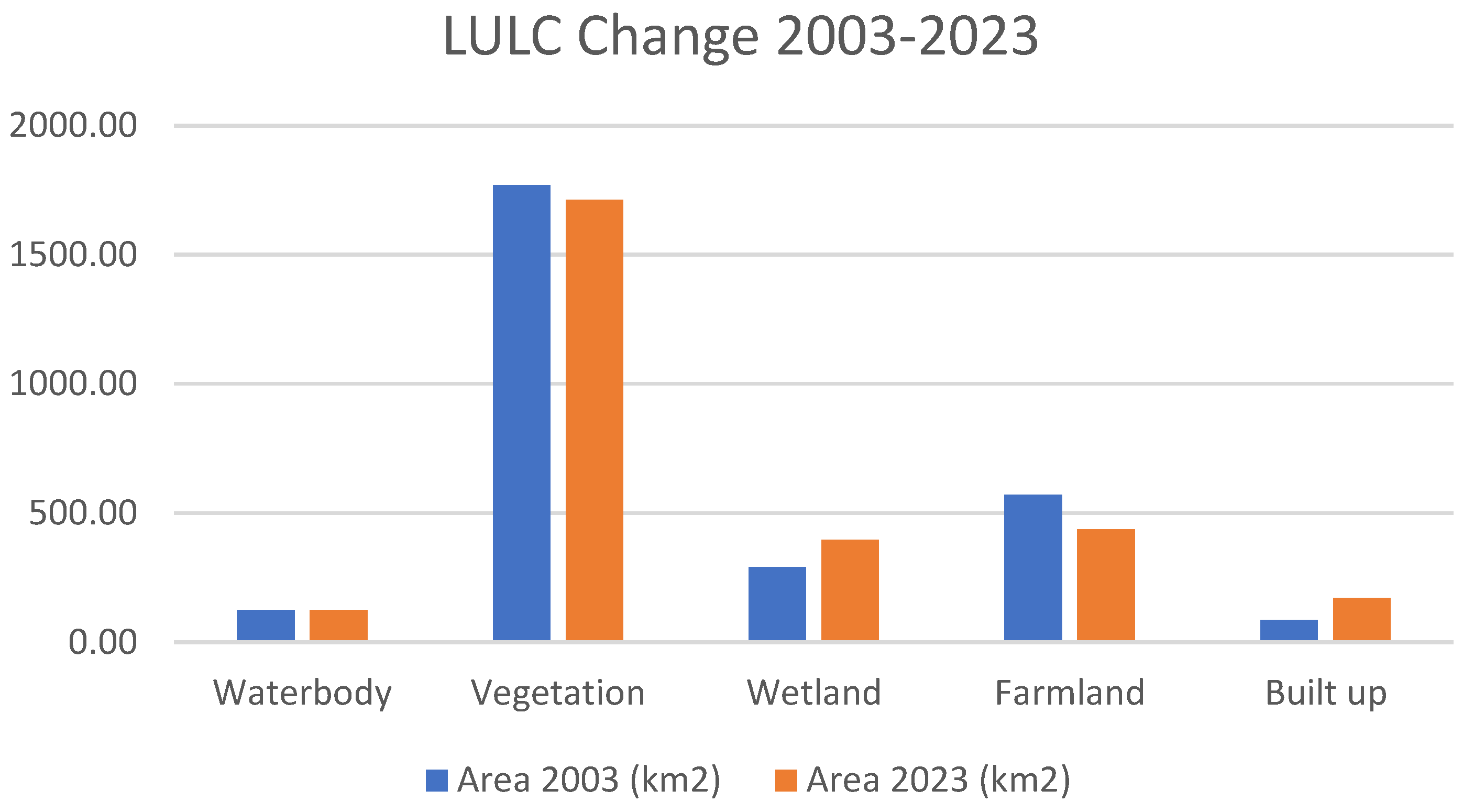
The temporal analysis result reveals that the IKN (Ibu Kota Nusantara) area has undergone a significant transition in land use/land cover (LULC), depicting changes in land utilization that reflect a variety of ecological, economic, and social factors. The data presented indicates a complex shift in LULC patterns with broad implications for environmental governance and regional planning. From a hydrological perspective, there has been a marginal decrease in the area of water bodies, from 125.76 km² in 2003 to 125.038 km² in 2023. This phenomenon can be attributed to anthropogenic interventions such as urbanization, which reduces land area through reclamation, or could also be due to natural hydrological shifts resulting in changes to the extent of water bodies. Vegetation, encompassing forests and other vegetative formations, has decreased, reflecting potential deforestation or land conversion to other uses such as agriculture or urban infrastructure. With a decrease from 1769.05 km² to 1712.467 km², this phenomenon indicates a potential loss of biodiversity and changes in carbon stock and ecosystem services.
Conversely, there has been a significant increase in the wetlands area, from 290.52 km² to 396.500 km². This increase could indicate successful efforts in wetland conservation, responses to changes in rainfall patterns, or ecological restoration initiatives promoting critical peatland rehydration. This change might also indicate shifts in freshwater ecosystem dynamics, positively impacting the conservation of aquatic species and microclimate regulation. Meanwhile, the built-up area reflects the most drastic growth, with an expansion from 86.63 km² to 171.354 km², indicative of rapid urbanization. This growth represents massive infrastructural investment, urban space expansion, and an increased demand for commercial organization and facilities, signifying a regional economic evolution towards urbanization as a primary driver of land change. Ultimately, the decrease in agricultural land from 569.56 km² to 436.105 km² may illustrate an economic transition from the agrarian sector to industry or services or the conversion of agricultural land to urban or vegetative uses triggered by developmental pressures. This reduction could long-term impact local food security and the social structure of communities dependent on agriculture.
Figure 3.
LULC Change in IKN Nusantara Area 2003-2023; Source: Author (2024).
Figure 3.
LULC Change in IKN Nusantara Area 2003-2023; Source: Author (2024).
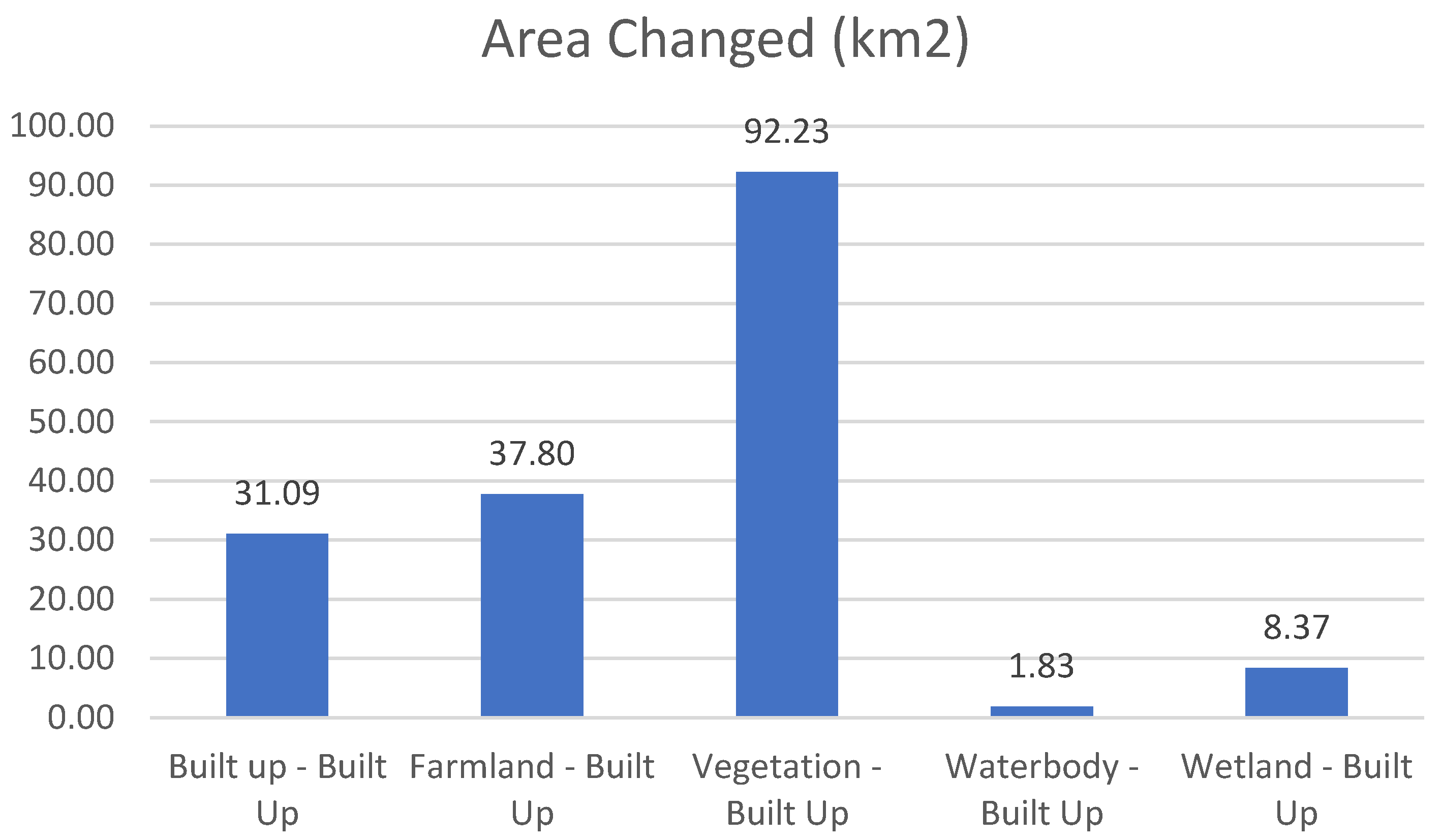
The findings show a significant change in land use in the IKN area from 2003 to 2023, explicitly shifting towards developed land use. The increase of 31.09 km² in developed land in areas previously categorized as Built-Up indicates a process of intensification and densification within an urban context. This suggests the expansion of existing zones, showcasing infrastructure development and population growth within defined urban boundaries. The change from Farmland to Built-Up, covering 37.80 km², represents a notable transition from agricultural land to developed land use. This shift reflects socio-economic conditions where agricultural lands may be sacrificed to support urban expansion or infrastructure development. The loss of agricultural land could significantly impact local food production and farming practices.
The most substantial change observed is the conversion of Vegetation to Built-Up, amounting to 92.23 km². This represents a substantial land conservation with vegetation cover to developed land use, which can be associated with deforestation for urban or industrial development. This transformation has profound ecological consequences, including reducing ecosystem services, carbon stock, and wildlife habitat. The change from ‘Waterbody’ to Built-Up is minimal, covering only 1.83 km². Despite its small scale, this change raises concerns regarding water resource extinction and management, considering that converting water bodies to developed land could affect the quality and quantity of available water resources. Lastly, the transition from ‘Wetland’ to Built-Up covering 8.37 km² is also noteworthy. Wetlands are crucial ecosystems, providing essential ecological functions such as flood mitigation, pollutant filtration, and biodiversity maintenance. This conversion may indicate developmental pressure on wetlands and raise concerns over the loss of ecological functions they provide.
Figure 4.
Area Changed in IKN Nusantara Area 2003-2023; Source: Author (2024).
Figure 4.
Area Changed in IKN Nusantara Area 2003-2023; Source: Author (2024).
The cumulative transformation of land into Built-up areas amounts to 171.33 km², which reflects a predominant trend in the developmental dynamics of the IKN area throughout the evaluated period. Further research is imperative to fully comprehend the ramifications of this transformation, which encompass environmental, economic, and societal impacts. The dramatic alteration of land underscores the necessity for a sustainable development approach that harmonizes growth with conserving natural resources and ecosystems.
The land transformation within the IKN Nusantara area is characterized by a significant reconfiguration in land allocation, heralding a new era replete with socio-economic and environmental meanings and challenges. The visible shift on a grand scale from traditional agrarian sectors to urban infrastructure could disrupt indigenous social systems and local economies, which have historically relied on natural resources and agriculture as the cornerstone of community life. The reduction of agricultural land poses risks to food security and cultural identity, while deforestation due to urban expansion threatens the critical functions of forests as providers of ecosystem services, such as carbon sequestration and climate regulation. Conversely, the loss of wetlands threatens extreme climate events, diminishes biodiversity, and weakens the natural air filtration capacity, potentially culminating in conflicts over water resource usage. This transformation also risks engendering tensions among community groups due to the uneven distribution of developmental benefits and borne losses. The diminishing green spaces and water areas jeopardize the quality of life and public health, escalating pollution and reducing access to clean natural resources.
Further, Indonesia’s urbanization has grown significantly, with the urban population increasing from 22.3% in 1980 to 55% in 2013. This is particularly notable in Java, where urban residents constitute 70% of the population compared to 26% in non-Java areas. This surge, propelled by migration and administrative changes, has bolstered cities like Jakarta, Bandung, and Surabaya in population density and economic prominence despite a slowing population growth rate from 2.34% annually during 1970-1980 to 1.37% between 1990-1994. This urban growth, however, comes with environmental costs, as seen in declining Environmental Quality Index (EQI) values due to industrial and vehicular pollution, underscoring the urgency for sustainable urban development (Ilham, 2021; Wilonoyudho et al., 2017). Additionally, research by Olivia et al., (2018) shows that urban areas are expanding at a rate of 2.0% annually, mainly at the expense of non-agricultural lands, which somewhat alleviates concerns about urbanization encroaching on farmland. Nevertheless, relocating the capital to East Kalimantan presents a direct challenge to environmental sustainability, with significant losses in carbon storage and natural habitats. The scenario calls for a thoughtful approach to urban planning that balances growth with environmental protection, particularly emphasizing the need for initiatives to prevent deforestation and wetland destruction and ensure biodiversity conservation amidst urban expansion.
Figure 6.
Indonesia’s Deforestation 2013-2022; Source: Adapted from BPS (2024).
Figure 6.
Indonesia’s Deforestation 2013-2022; Source: Adapted from BPS (2024).
Recent data on deforestation in Indonesia, with a particular emphasis on East Kalimantan and the national total from 2013 to 2022, reveals informative trends relevant to conservation efforts and natural resource management within the country. East Kalimantan, a province renowned for its extensive tropical rainforests, has experienced fluctuations in deforestation rates over the past decade. In 2013-2014, deforestation in this province was recorded at 383.394 square kilometers, significantly increasing to 1,009.308 square kilometers in 2014-2015 and peaking in 2015-2016 at 1,086.82 square kilometers. Following this increase, a downward trend in deforestation was observed in East Kalimantan, with deforestation rates decreasing to 949.818 square kilometers in 2016-2017 and continuing to decline to 137.588 square kilometers in 2021-2022. This decline may reflect the impact of forest conservation policy implementation, enhanced environmental protection efforts, and growing awareness of the importance of forest maintenance for ecological and social sustainability. On a national scale, Indonesia exhibited a similar pattern, with total deforestation reaching its zenith in 2014-2015 at 21,843.630 square kilometers before decreasing. National deforestation figures have gradually reduced year after year, indicating progress in forest management and conservation efforts across Indonesia. The reduction in deforestation in East Kalimantan and nationally signifies a positive step towards more sustainable natural resource management. Nevertheless, it still requires the sustained commitment of all stakeholders to maintain this positive trend (BPS, 2024).
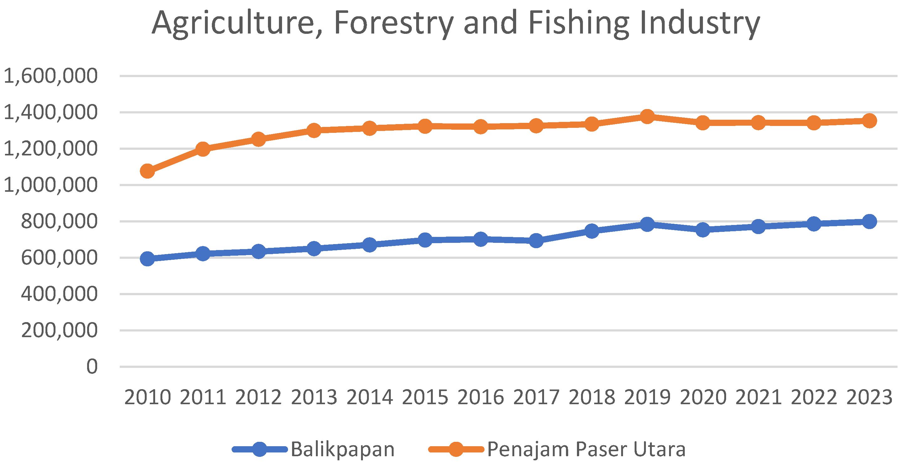
The analysis result reveals a trend of growth in the agriculture, forestry, and fisheries sectors in Pontianak and North Penajam Paser, allowing for several conclusions regarding the potential impact on land use and deforestation around the New Capital Area (IKN), including Balikpapan and PPU. Consistent growth in these sectors, mainly driven by increased demand for agricultural and forestry products, could lead to expanding agricultural and forestry lands. In areas experiencing economic growth, such as around the IKN, this may result in the conversion of forest land into agricultural or plantation lands. This increase could also stem from more significant investment in agricultural and forestry technologies, necessitating new land clearing. Without sustainable practices and proper forest management, growth in these sectors could accelerate deforestation. Excessive logging to meet market demands or expanding agricultural areas could reduce forest cover. This often occurs when economic growth is not aligned with solid environmental policies or when land use and forest management enforcement is lacking.
Figure 7.
Agriculture, Forestry and Fishing Industry in IKN Area; Source: Adapted and Analyzed from BPS (2024).
Figure 7.
Agriculture, Forestry and Fishing Industry in IKN Area; Source: Adapted and Analyzed from BPS (2024).
As indicated by data from the areas near the new capital in Pontianak and Penajam Paser Utara, the growth in the agriculture and forestry sectors carries significant implications for land use. It could engender environmental conflicts in the surrounding areas of Balikpapan and PPU. Expanding these sectors heightens pressures for converting forest lands into agricultural or plantation areas. This land-use change not only diminishes primary and secondary forest coverage, which serves crucial carbon sequestration and biodiversity habitat functions, but may instigate conflicts between economic growth interests and environmental conservation. Furthermore, a land conversion often disproportionately benefits large capital owners, negatively impacting local communities and indigenous peoples reliant on forests for their livelihoods. This scenario exacerbates social inequalities and fosters tensions between agroforestry corporations and local populations. Unchecked agricultural expansion risks soil degradation, loss of fertility, and erosion issues, leading to a decline in overall environmental quality. Unsustainable land management practices near the new capital may introduce complex environmental issues, such as hydrological alteration affecting river systems and groundwater, impacting human water use and aquatic ecosystems. Additionally, such changes may increase carbon emissions due to forest reduction, contravening global and national efforts to mitigate climate change.
Another significant concern is the pressure on the native ecosystems surrounding the new capital area. This area is home to 34 critically endangered species, 105 endangered species, and 301 vulnerable species, highlighting a substantial portion of biodiversity at high risk of extinction (IUCN, 2020). The presence of these threatened and vulnerable species underscores the urgent need for conservation and habitat protection efforts around IKN, including in Balikpapan and Penajam Paser Utara. Ecosystem conflicts in areas like IKN arise from development pressures and economic growth against natural habitats. With species listed by the IUCN ranging from critically endangered to vulnerable, this area faces significant challenges in balancing human economic needs with biodiversity sustainability. Species such as the proboscis monkey, sun bear, and pangolin, all requiring preserved environments to survive, could be adversely affected by uncontrolled infrastructure development and agricultural expansion. Land-use changes leading to deforestation, habitat fragmentation, and pollution could diminish the quality and quantity of available habitats for flora and fauna, indirectly reducing threatened species populations and accelerating extinction. Particularly in the context of IKN, there is a risk that rapid, unplanned development without adequate ecological planning could exacerbate the situation. The conflict between economic interests and environmental conservation sharpens in high-biodiversity areas like this. Resource extraction activities, construction, and agricultural or plantation development are often seen as economic drivers, yet the long-term consequences of ecosystem degradation demand serious consideration. Such losses impact biodiversity and crucial ecosystem services vital for human welfare, including water filtration, carbon absorption, and erosion control (Niesenbaum, 2019; Pisani et al., 2021).
4.2. Socio-Cultural Conflict
Population Exodus to the New Capital and Local Indigenous Communities Displacement
Urban development, driven by population growth and economic expansion, often leads to the displacement of local indigenous communities, undermining their social cohesion and cultural traditions (Gilbert, 2016). Gentrification and the commercialization of cultural sites further exacerbate this issue by erasing indigenous identities and disrupting traditional communal bonds. The consumption of green spaces and the relentless urban spread, facilitated by affordable transportation, disconnect indigenous populations from their natural environments, essential to their cultural and spiritual practices (Cole et al., 2021; Zuk et al., 2018). This urban expansion challenges traditional urban planning and necessitates a balanced approach that respects indigenous rights and heritage, ensuring that modern urbanization strategies do not marginalize these communities or sever their connection to ancestral lands (Angel, 2023).
Another concern arising from this exodus is the displacement of local communities, particularly indigenous and marginalized groups. The project will likely require the acquisition of large amounts of land, which could result in the forced displacement of local communities from their homes and ancestral lands (Zuk et al., 2018). This forced displacement could have broad social impacts, including the loss of livelihoods, disruption of social networks, and erosion of cultural practices and traditions. The displacement will disproportionately impact marginalized groups, who may already be marginalized in decision-making processes. Therefore, it is crucial to ensure that these communities are adequately consulted and that their rights and interests are protected in the development process. Another potential social impact of the new capital city project is the change in cultural practices and social dynamics. The construction of the capital could bring significant changes to the area, including changes in economic and social structures, cultural practices, and traditions (Azmy, 2021; Farida, 2021). Mass migration can disrupt social networks as individuals grapple with making new connections and acclimating to unfamiliar environments. The arrival of new residents can impact the customs and culture of surrounding communities. As more people flock to the new capital, cultures and habits will be blended, which could have either positive or negative consequences. Sharing ideas and traditions may foster a more diverse and inclusive society (Blumenstock et al., 2023). However, newcomers may need to familiarize themselves with local norms and conventions, which could lead to misunderstandings and tensions between different groups, exacerbating social rifts. Additionally, the influx of new residents may intensify competition for jobs, housing, and other resources, potentially leading to an uptick in crime and other social issues. As some individuals resort to illegal means to satisfy their basic needs, societal unrest and crime rates could increase (Farida, 2021).
In Brazil, urban expansion, especially the shift from tobacco farming to urban development, has dramatically reshaped socio-cultural dynamics, altering the fabric of community life and cultural identity, particularly in places like Arapiraca. This transformation from an agrarian to an urban society has disrupted traditional living methods as people migrate to cities for better opportunities, thus changing community ties and cultural interactions. The rapid urbanization process, fueled by government initiatives, has increased population density and housing issues and led to environmental degradation and heightened social inequalities. This urban growth presents a dual-edged sword of opportunities and socio-environmental challenges, underscoring the importance of inclusive urban planning that addresses the diverse impacts on residents’ socio-cultural lives (Adam et al., 2023; Correia Filho et al., 2022). The encroachment of urban areas into traditional agricultural lands disrupts communities’ socio-economic and cultural fabric, as Atanur, (2011) notes, with a significant loss of cultural heritage linked to rural customs. Urbanization’s effect on population dynamics and social interactions calls for urban designs that preserve cultural landscapes amidst rapid changes. Aziz et al., (2012) highlight the psychological and lifestyle changes due to urbanization, affecting social dynamics and individual well-being. The push towards urbanization also threatens indigenous peoples’ cultural and spiritual heritage by disconnecting them from their ancestral lands, leading to economic marginalization and a dilution of cultural identities and community cohesion, as observed by Ashifa (2022) and Debele (2017). This necessitates urban planning that safeguards cultural heritage and supports the socio-cultural existence amidst the complexities of urban expansion (Chandel & Mathewos, 2023).
The relocation of Indonesia’s capital city holds significant potential to generate social and economic conflicts if not adequately managed. This massive exodus involves communities accustomed to Jakarta’s living standards, which could lead to imbalances in East Kalimantan. These imbalances are already present and could be exacerbated by the relocation plans. Social conflicts may arise from interactions among diverse, multicultural groups with differences in physical appearance, knowledge, customs, and beliefs (Shimamura & Mizunoya, 2020). In Indonesia, conflicts arising from cultural differences often become destructive, resulting in clashes among ethnic, religious, racial, or other groups, as seen in the conflicts in West and Central Kalimantan. The tendency to view one’s own culture as central and superior can exacerbate these tensions, where the "Us vs Them" phenomenon creates feelings of threat and hostility between groups, even without objective or rational reasons, potentially sparking damaging ethnic conflicts (Iskandar & Heri Kurniawansyah, 2023; Miah, 1999). Structurally, only sometimes harmonious inter-ethnic relations can lead to conflicts due to cultural differences. Tensions between migrants and indigenous people, such as between the Dayak and Madura tribes, are often latent and can escalate into open conflicts if not carefully resolved. Besides ethnic conflicts, the capital relocation may also threaten the continuity of local cultures, such as Long Houses, sacred sites, and traditional cultural activities that are not yet fully developed or integrated into the new capital’s development plans (Dwi Djayanti et al., 2022).
Figure 8.
Population Growth Rate in IKN Area; Source: Adapted and Analyzed from BPS (2024).
Figure 8.
Population Growth Rate in IKN Area; Source: Adapted and Analyzed from BPS (2024).
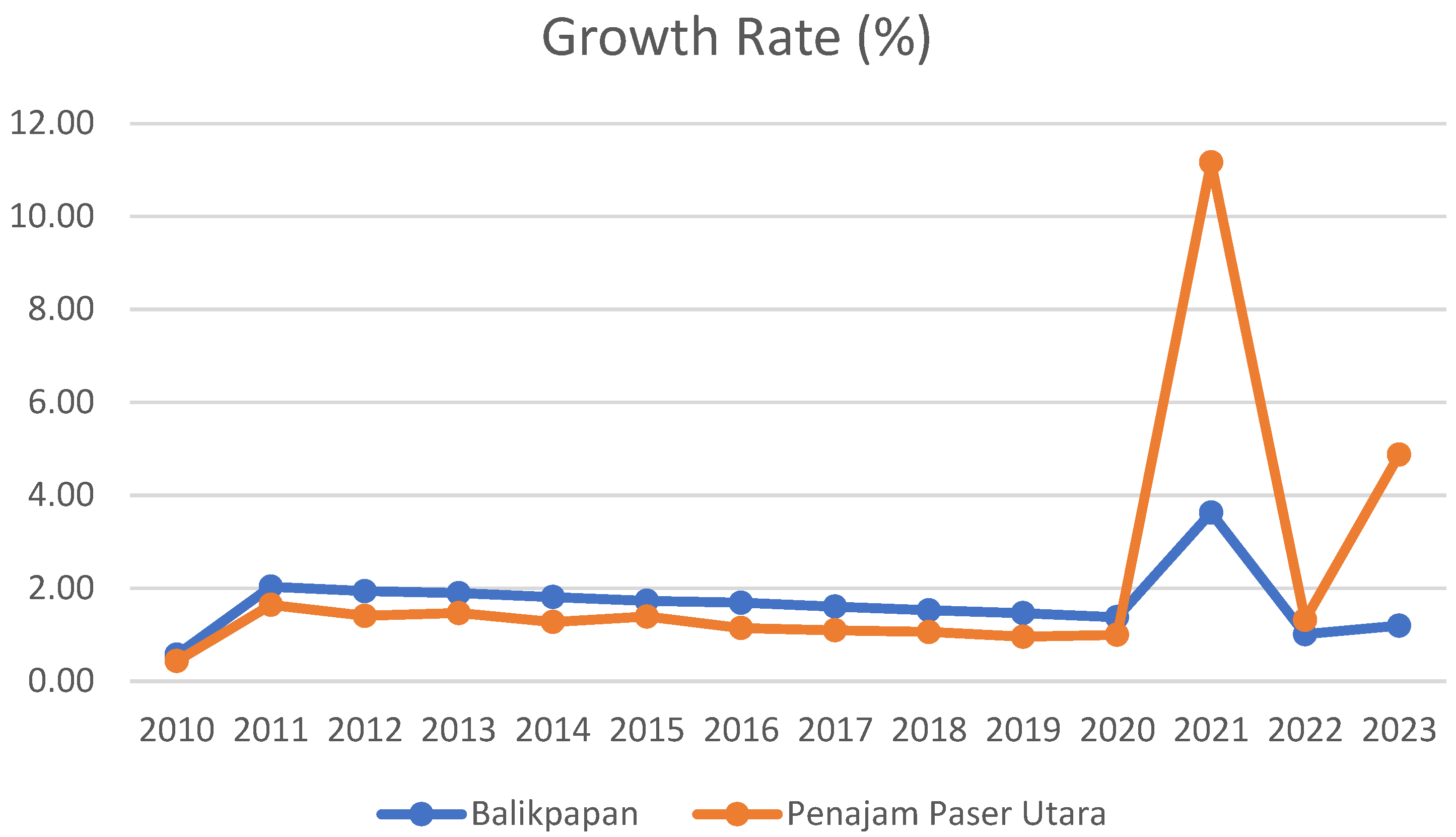
Since the designation of Nusantara as Indonesia’s new capital city, there has been a significant migration phenomenon to the surrounding areas, particularly North Penajam Paser and Balikpapan (Nurulhuda et al., 2021). This migration flow reflects a demographic transition driven by various factors, including improved economic prospects, increased employment opportunities, and infrastructure development associated with the construction of the new capital. The populations in both areas have shown substantial increases, with Balikpapan experiencing an addition of 146,032 individuals and North Penajam Paser increasing by 48,975. The significant migration to areas around Nusantara, especially North Penajam Paser and Balikpapan, has profound implications for the socio-cultural dynamics of these areas. The rapid influx of a large population can pressure local resources, which often need to be prepared for the new wave of inhabitants. Such tension may arise from competition for jobs, land, housing, and limited access to public services. Indigenous populations may feel displaced due to rapid changes in their living areas’ economic and social structures.
Culturally, an increased population from diverse backgrounds can precipitate conflicts or friction among different values, customs, and traditions. Newcomers introduce distinct habits, values, and lifestyles, which, if not judiciously managed, can lead to social disharmony (Eren et al., 2015; Nettle et al., 2007). For instance, misunderstandings or clashes over space and resource use or disagreements on land management and development may arise. Such tensions can be exacerbated by socio-economic disparities between old and new residents, with indigenous populations potentially feeling displaced from their land and economic opportunities by more resourceful and skilled newcomers. Additionally, a growing population may accentuate imbalances in wealth distribution, access to education, and healthcare services, fostering social dissatisfaction and eroding community cohesion (McMaughan et al., 2020; Schenkman & Bousquat, 2021).
Community concerns regarding the relocation of the national capital to North Penajam Paser in East Kalimantan encompass several critical aspects, including the potential marginalization of local populations, loss of local identity and culture, and impacts on land and livelihoods. These concerns reflect fears of rapid changes and pressures that could erode cultural values and traditions due to modernization. The Bappenas report acknowledges the vulnerability of indigenous communities to swift changes, such as the relocation of capital cities. To address this, it is recommended that economic livelihoods based on forests and natural resources be maintained, ensuring the preservation of community identities and livelihoods and their welfare. On the other hand, positive sentiments have been expressed by the community and traditional leaders in North Penajam Paser, indicating their readiness to face the capital relocation, including anticipating the arrival of new human resources with diverse cultures. This demonstrates the adaptability and openness of the North Penajam Paser community to other cultures, evidenced by the hosting of various cultural events that integrate multiple cultures without erasing their indigenous culture. However, concerns also exist regarding competition and the impact of capital relocation on education. Local communities fear being left behind, particularly as education in East Kalimantan is perceived to be less competitive than Jakarta’s educational quality (Dwi Djayanti et al., 2022).
4.3. Land Disputes
Land tenure conflicts in Indonesia stem from the historical evolution of land rights, transitioning from pre-colonial distributions based on loyalty to the colonial imposition of formal land tenure systems for taxation and labor. The 1870 Agrarian Law and the 1960 Basic Agrarian Law introduced significant changes, including state ownership of unoccupied land and recognition of communal rights, but also allowed land revocation for public interest, often leading to disputes over compensation and land use (Pinuji et al., 2023; Singirankabo & Ertsen, 2020). Modern land tenure conflicts are fueled by land commercialization driven by tourism, agriculture, and urban development, increasing land value and leading to speculative practices. Traditional landholders face challenges from the government and private projects, often needing adequate compensation or legal support. Numerous laws and regulations exacerbate the complexity of these conflicts, making landholder registration and certification difficult and leaving them vulnerable to dispossession (Agegnehu et al., 2021; Msangi et al., 2022). Resolving these conflicts requires balancing traditional land rights with development goals and ensuring equitable and transparent legal frameworks that respect historical land tenure systems while supporting Indonesia’s growth (Lucas, 1992).
The land holds fundamental value as a foundation for human habitation, a source of vital resources, and a key element in global ecological systems, playing a significant role in shaping cultural identities and social structures (Grimm et al., 2000; F. Liu et al., 2023). Rapid urbanization threatens these socio-cultural and ecological equilibriums by igniting land use and distribution conflicts. Modern political theories often neglect the complex interplay between land’s universal necessity and its role in forming distinct community identities and ecological sustainability. A holistic approach to territorial rights, recognizing land’s multifaceted importance, is crucial for ensuring equitable access and preserving cultural and ecological diversity (Fan et al., 2022; Fu et al., 2023; Salem & Tsurusaki, 2024). Research by Pratomo et al., (2020) and Alamneh et al., (2023) underscores the socio-economic challenges urbanization poses, particularly the undermining of property rights and economic stability in peri-urban areas and the adverse impacts on peri-urban farmers in Ethiopia. These insights call for urban policies that consider the socio-economic effects of land expropriation and aim for a balanced urban expansion that safeguards agricultural lands and food security. Further, studies from China and Ethiopia by Weldearegay et al. (2021) and Gashu & Bahir (2015) highlight the exacerbation of poverty and social disparities following urban expansion, emphasizing the need for urban planning that addresses the challenges posed by rapid growth and informal settlements.
Setyo Prihatin et al. (2019) and Ilyas & Hamzah (2022) shed light on the complexities of land ownership conflicts in Indonesia, emphasizing the interaction of legal, socio-economic, and political elements in these disputes. The situation is further complicated by conflicts between local communities, businesses, and government bodies, necessitating multifaceted strategies to navigate land governance challenges. Hariri et al. (2022) study in Pakel Village illustrates the tension between historical community land rights and corporate ambitions, highlighting the need for legal systems that protect communal lands, promote transparent land use, and balance economic, social, and environmental interests. The negative impacts of displacing communities, such as income loss, poverty, and environmental harm, stress the importance of holistic urban planning and policies prioritizing vulnerable groups’ well-being, ecological preservation, and sustainable growth. Addressing the complexity of land disputes, marked by competing claims and vague legal standards, requires transparent, fair conflict resolution methods that integrate community rights with development and corporate needs, aiming for a harmonious blend of economic advancement, social equity, environmental care, and cultural integrity amidst rapid urban expansion.
The development process of Indonesia’s new capital city is a significant initiative that necessitates the active participation of the community in monitoring its execution. The project, spanning an area of 256 hectares in East Kalimantan, is anticipated to impact the land sector substantially. It requires a meticulous land acquisition process involving state-controlled lands and privately owned territories, underscoring the urgent need for a rigorous land acquisition framework. The construction in East Kalimantan, designated as a National Strategic Project, aims to expedite the realization of the capital city. The government must conduct land acquisitions based on valid land status data, ensuring fair and appropriate compensation. With nearly half of the land earmarked for development owned by the community, attention to potential agrarian conflicts during the acquisition process is crucial. The situation in Penajam Paser Utara and Kutai Kartanegara, identified by the Agrarian Reform Consortium as potential conflict hotspots, illustrates that large-scale infrastructure developments in Indonesia have historically led to conflicts. The instances of agrarian conflicts, often triggered by national strategic projects, highlight the importance of thoroughly evaluating how land acquisitions could lead to conflicts if not correctly managed. Therefore, land procurement should be carried out to enhance public welfare and social justice as part of the state’s responsibility in promoting broad-based development and societal well-being.
Table 1.
Land Status in East Kalimantan.
Table 1.
Land Status in East Kalimantan.
| Status |
Area |
% |
| Unspecified |
2518,35 |
0.97% |
| Unregistered State Land in Other Use Area (APL) |
73411,04 |
57.76% |
| Unregistered State Land in Forest Area |
48677,30 |
57.76% |
| Registered Land in Other Use Area (APL) |
31147,18 |
12.10% |
| Registered Land in Forest Area |
1614,90 |
0.62% |
Table 2.
Land Ownership Status in East Kalimantan.
Table 2.
Land Ownership Status in East Kalimantan.
| Status |
Area |
% |
| Unspecified |
4,356.42 |
|
| Land Controlled by Legal Entities |
96,091.89 |
1.69% |
| Land Controlled by the Community |
106,340.78 |
41.32% |
| Land Controlled by the Government |
5,790.09 |
2.25% |
| Uncontrolled Land |
44,789.59 |
17.40% |
Nearly half of the territory designated for the construction of the New Capital City is community-owned land, a condition necessitating attention to potential agrarian disputes. According to predictions by the Consortium for Agrarian Reform, the areas of North Penajam Paser and Kutai Kartanegara are likely to experience conflicts due to this development, a situation corroborated by previous national strategic projects across various areas often culminating in contention. The diversity of infrastructure triggering land disputes should serve as a lesson to avoid similar errors in land acquisition for the New Capital. Avoiding conflict hinges not solely on the act of land procurement but on implementing fair and accurate procedures, considering that land acquisition for public development is a state responsibility in fostering social welfare and justice, as well as an initial step towards national development that prioritizes the public’s welfare.
Table 3.
Land Tenure Conflicts in IKN Area.
Table 3.
Land Tenure Conflicts in IKN Area.
| No |
Year |
Title |
Conflict |
Sector |
| 1 |
2023 |
The apprehension of several Indigenous Community members from the coal mining site of PT Energi Batu Hitam (EBH) |
Manufacture |
Mining |
| 2 |
2023 |
The Indigenous Community of Balik Sepaku Refuses Displacement |
River Normalization |
Infrastructure |
| 3 |
2023 |
PT. WIN has not yet resolved the dispute concerning the encroachment upon land owned by residents of Kerayaan Village, East Kutai |
Oil palm plantation |
Plantation |
| 4 |
2021 |
Agrarian Conflict and the Criminalization of the Indigenous Dayak Marjun Community |
Ex-Plantation |
Plantation |
| 5 |
1987 |
The Conflict between the Community of Kampung Long Isun and PT Kemakmuran Berkah Timber (TBK) |
HPH |
Production Wood |
| 6 |
2008 |
The Conflict Between the Indigenous Muara Tae/Dayak Benuaq Community and PT. Borneo Surya Mining Jaya |
Coal |
Mining |
| 7 |
1975 |
The conflict between PT KEM and the Artisanal and Small-Scale Miners (ASM) |
Emas |
Mining |
| 8 |
2014 |
The Conflict between the Dayak Benuaq Indigenous Community of Muara Tae Village and PT. Munte Waniq Jaya Perkasa |
Oil palm plantation |
Plantation |
Over the past few decades, the escalation of land and natural resource-based conflicts in Indonesia has continuously increased. The Agrarian Reform Consortium (2015-2018) recorded as many as 1,769 agrarian conflict incidents involving indigenous communities, farmers, and rural societies, with an annual increase of approximately 13 – 15%. YLBHI (2018) data indicate 300 cases of structural agrarian conflicts across 16 provinces, covering 488,407.77 hectares. These conflicts are primarily caused by the government issuing concession permits for infrastructure development projects and corporate concessions on community lands. The government has long recognized errors in the management of agrarian resources and natural resources, attempting correction through TAP MPR No—IX of 2001 on agrarian reform and natural resource management. Unfortunately, nearly two decades after the issuance of this decree, its implementation by the government has not been conducted earnestly. As a result, land and natural resource-based conflicts harm the community and lead to ecological damage and state losses.
Figure 9.
Land Conflicts in IKN Area; Source: Author (2024).
Figure 9.
Land Conflicts in IKN Area; Source: Author (2024).
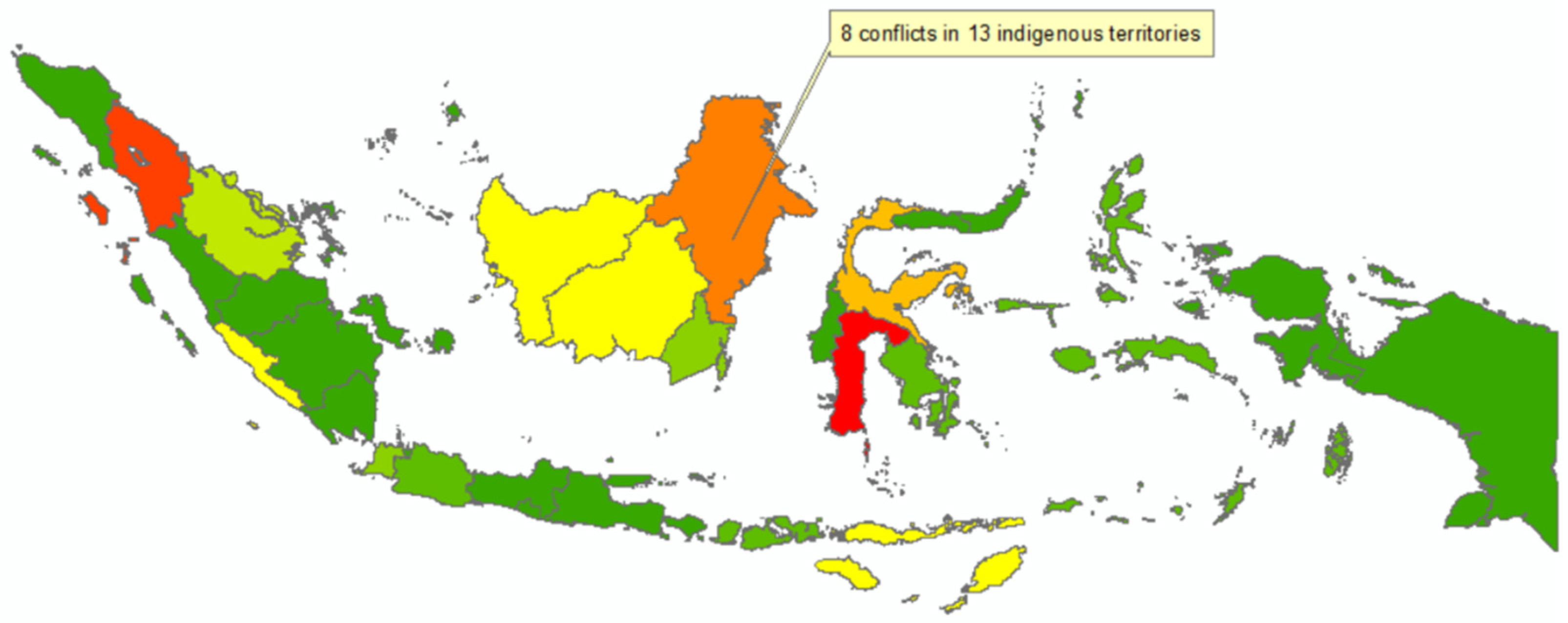
The area designated as the site for the new capital city (IKN) is not exempt from land disputes due to differing claims and overlapping permits. At least 13 indigenous territories in North Penajam Paser District will be affected by the IKN location. Moreover, large-scale plantation concession permits covering 30,000 hectares overlap with indigenous community territories. Conflicts between indigenous communities and corporations over land rights have yet to be resolved, suggesting that the IKN infrastructure development could exacerbate ongoing conflicts.
4.4. Economic Conflict
Over the last five decades, economic disparities within urban areas globally have widened due to unequal distribution of wealth, income, and resources. Globalization, technological progress, policy decisions, and systemic discrimination contribute to varied manifestations of inequality, including disparities in income, wealth, and access to essential services. While economic models suggest market self-correction, real-world complexities often lead to persistent inequalities. Despite the potential of disequilibrium to spur growth, the increasing income gap highlights the urgency for holistic strategies aimed at equitable resource distribution, echoing scholars’ calls for more inclusive urban development (Chung, 2015; Yap et al., 2021).
The World Cities Report 2020 emphasizes the urgent need to address housing crises and transport disparities in urban development, which significantly impact socio-economic conditions and equitable access to opportunities. These issues are exacerbated by affordability challenges, inadequate policies, and the digital marketplace’s effects, alongside systemic inequalities related to class, race, ethnicity, and gender, leading to urban segregation. The COVID-19 pandemic has further highlighted these disparities, making local government action in housing and urban planning critical for promoting equitable growth. Transport inequalities, stemming from infrastructural and service discrepancies, obstruct socio-economic advancement and contribute to social fragmentation, underscoring the importance of initiatives like UN Women’s for inclusive, safe transport to enhance social inclusion and urban resilience (Alipour & Dia, 2023; McGowan et al., 2021). Additionally, the interplay of food scarcity, poverty, and population dynamics, influenced by globalization, trade policies, and climate change, exacerbates economic disparities. Globalization and trade policies can disadvantage developing nations, while climate change impacts food production in poorer areas, deepening global inequalities. Strategic capital city relocations could address these disparities by encouraging regional development and fostering equitable economic distribution, contingent on inclusive and thoughtful planning to prevent worsening or new inequalities (Yap et al., 2021).
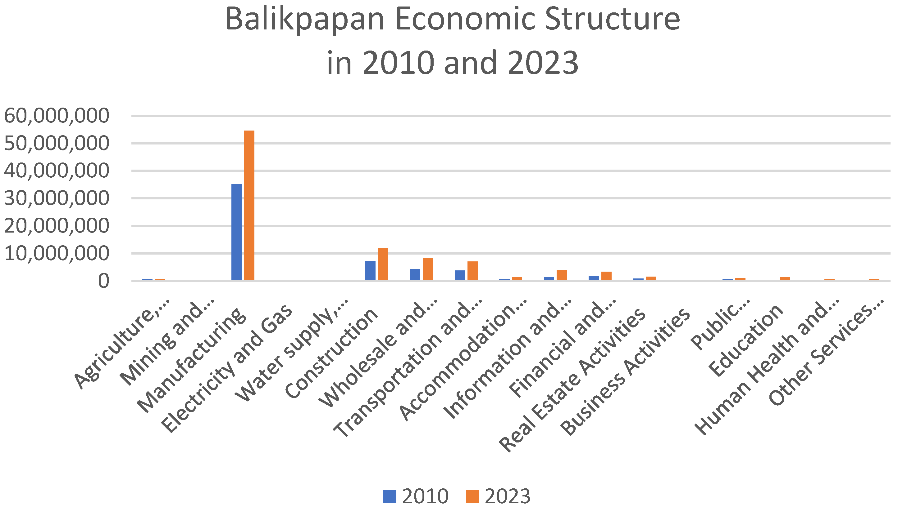
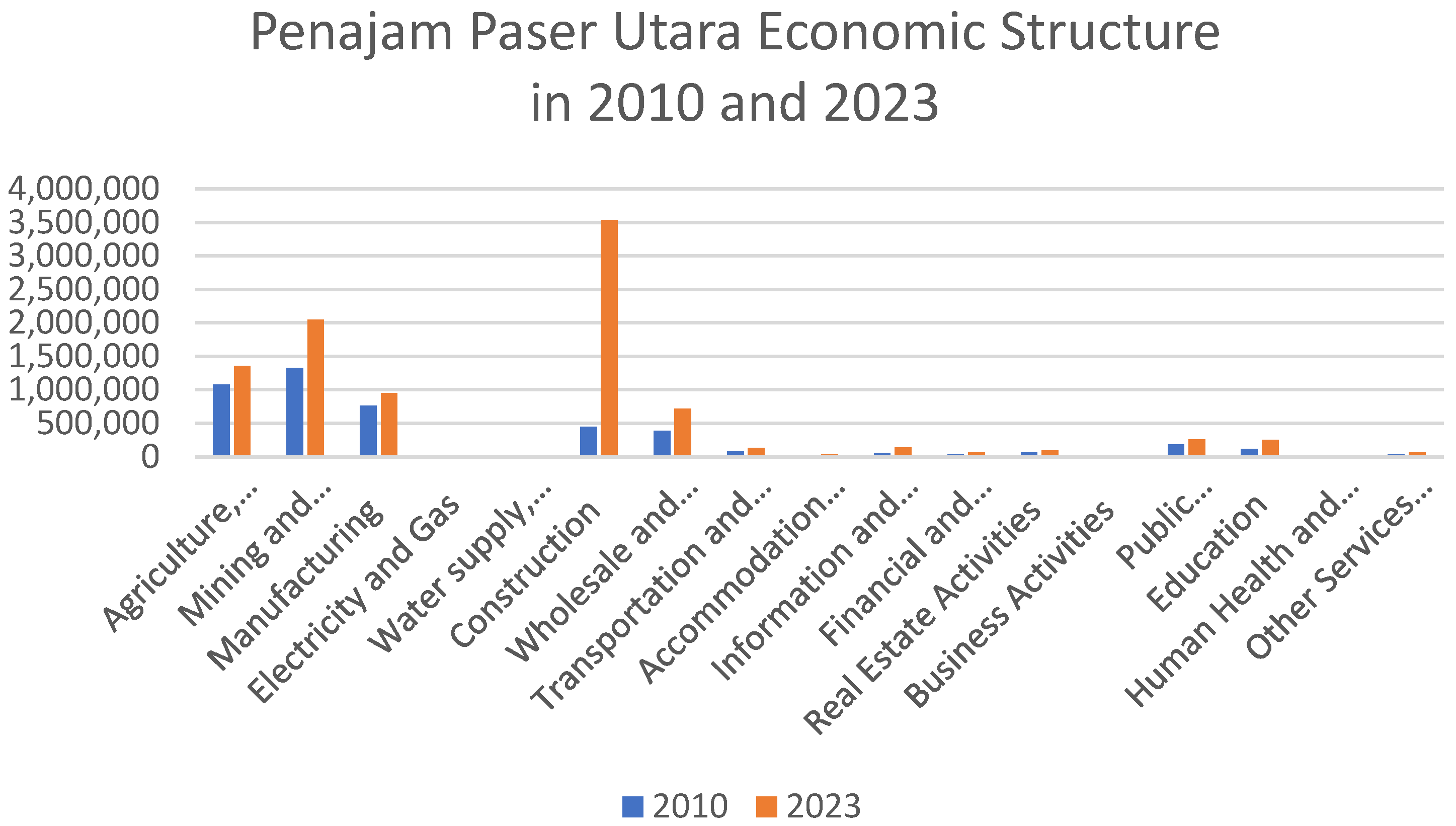
The development of the new capital area, located near Balikpapan and Penajam Paser Utara (PPU), is anticipated to catalyze local economic expansion. However, challenges and socio-economic dynamics may arise as consequences. In Balikpapan, rapid advancements in manufacturing, as evidenced by its increasing contribution to the GRDP, promise employment and investment opportunities. Nevertheless, potential conflicts could emerge if economic growth results are not equitably distributed and this sector monopolizes local resources and labor. The inequality indicated by the Gini ratio might worsen due to the direct impact of economic and population structure changes with the capital’s development. Conversely, PPU’s progress in agriculture and construction supports the capital’s economic advancement. However, there is a necessity for management strategies to ensure that such progress does not lead to further inequalities or competition over resources. This growth must be carefully guided to support the capital’s agenda without overburdening local communities and ecosystems, achieving the desired economic growth without compromising social or environmental stability.
Figure 10.
Indonesia’s Deforestation 2013-2022; Source: Adapted from BPS (2024).
Figure 10.
Indonesia’s Deforestation 2013-2022; Source: Adapted from BPS (2024).
Figure 11.
Indonesia’s Deforestation 2013-2022; Source: Adapted from BPS (2024).
Figure 11.
Indonesia’s Deforestation 2013-2022; Source: Adapted from BPS (2024).
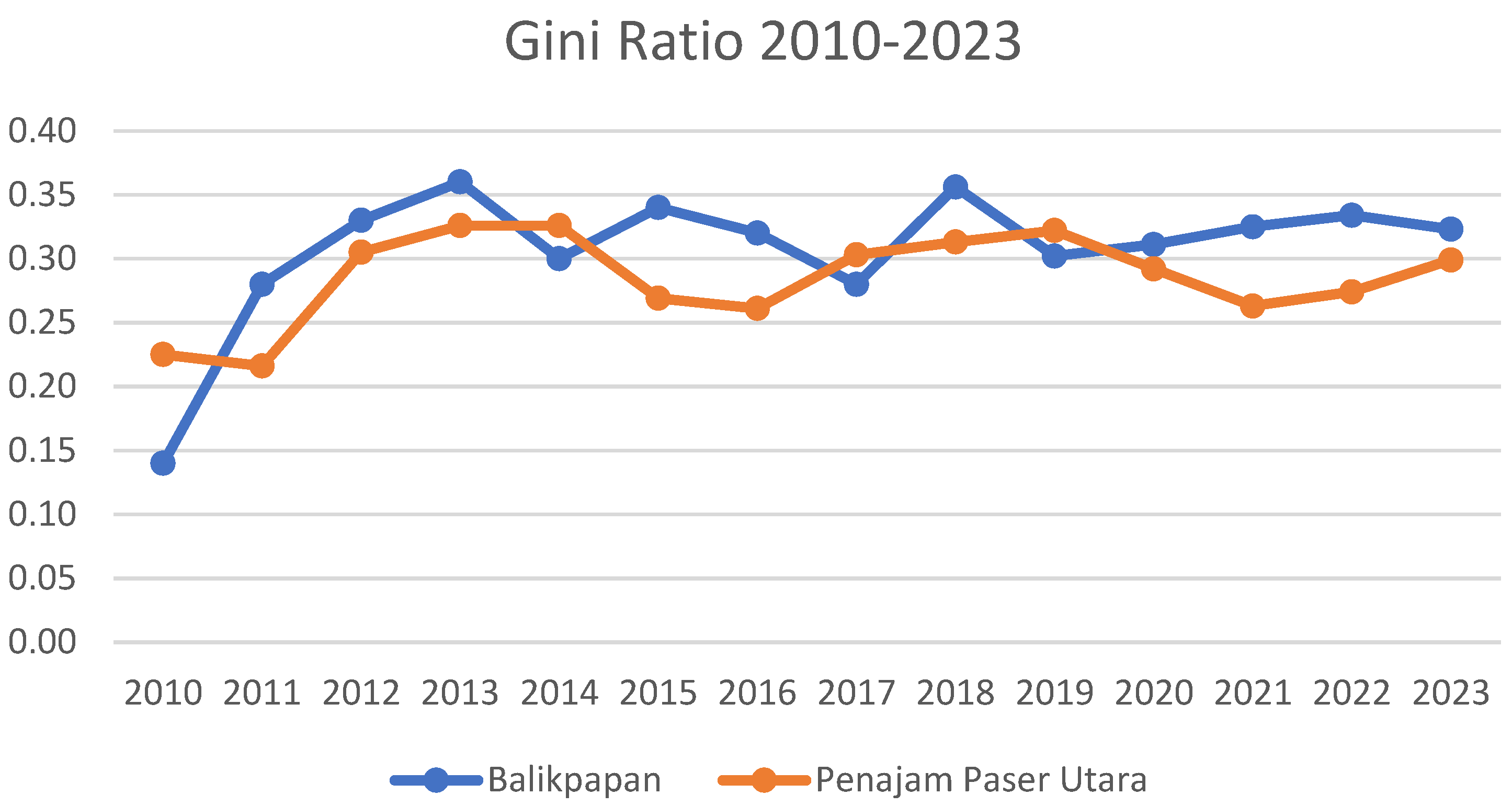
The Capital City of Nusantara (IKN) development in nearby areas such as Balikpapan and PPU presents significant potential for local economic growth. However, it may also lead to economic pressures and conflicts. The rapid expansion of the manufacturing sector in Balikpapan, evidenced by its increasing contribution to the GDP, could attract investment and create new employment opportunities. However, it might also lead to tensions if the industry exhausts local resources or labor without equitable wealth distribution. The stability of the Gini ratio post-2017 indicates that economic inequality has become a persistent phenomenon, potentially exacerbated by economic and demographic shifts due to IKN’s construction. Meanwhile, PPU’s growth in the agriculture and construction sectors could contribute to IKN’s economy, yet careful regulation is required to prevent resource competition or further inequalities.
Figure 12.
Gini Ratio in IKN Area 2010-2023; Source: Adapted from BPS (2024.).
Figure 12.
Gini Ratio in IKN Area 2010-2023; Source: Adapted from BPS (2024.).
In addition, economic pressures stemming from inequality also play a role in the IKN area, as evidenced by the Gini ratio. The relationship between economic growth and wealth distribution can be complex, as seen in the fluctuating patterns of the Gini ratio and unemployment rates across different areas. While Balikpapan experienced increased income equality in the early 2010s, this trend may not be sustained, indicating that economic growth has yet to be fully inclusive. Similarly, a decline in unemployment in PPU following 2017 may reflect improvements in the labor market, but it does not necessarily coincide with enhanced income equality. It is crucial to prioritize comprehensive and equitable economic growth and employment opportunities to avoid any social tensions that may arise during rapid changes. With the development of the new capital, there will be a surge in construction and demographic shifts, which will offer opportunities for specific industries. However, this growth can also lead to increased living costs and instability in the labor market. The development of infrastructure and new residential areas can benefit the construction sector. Still, planning carefully to minimize any negative impacts on the environment and local communities is essential. By balancing economic growth and social development, we can prevent potential conflicts and ensure that the new capital fosters inclusive and sustainable growth throughout the region.
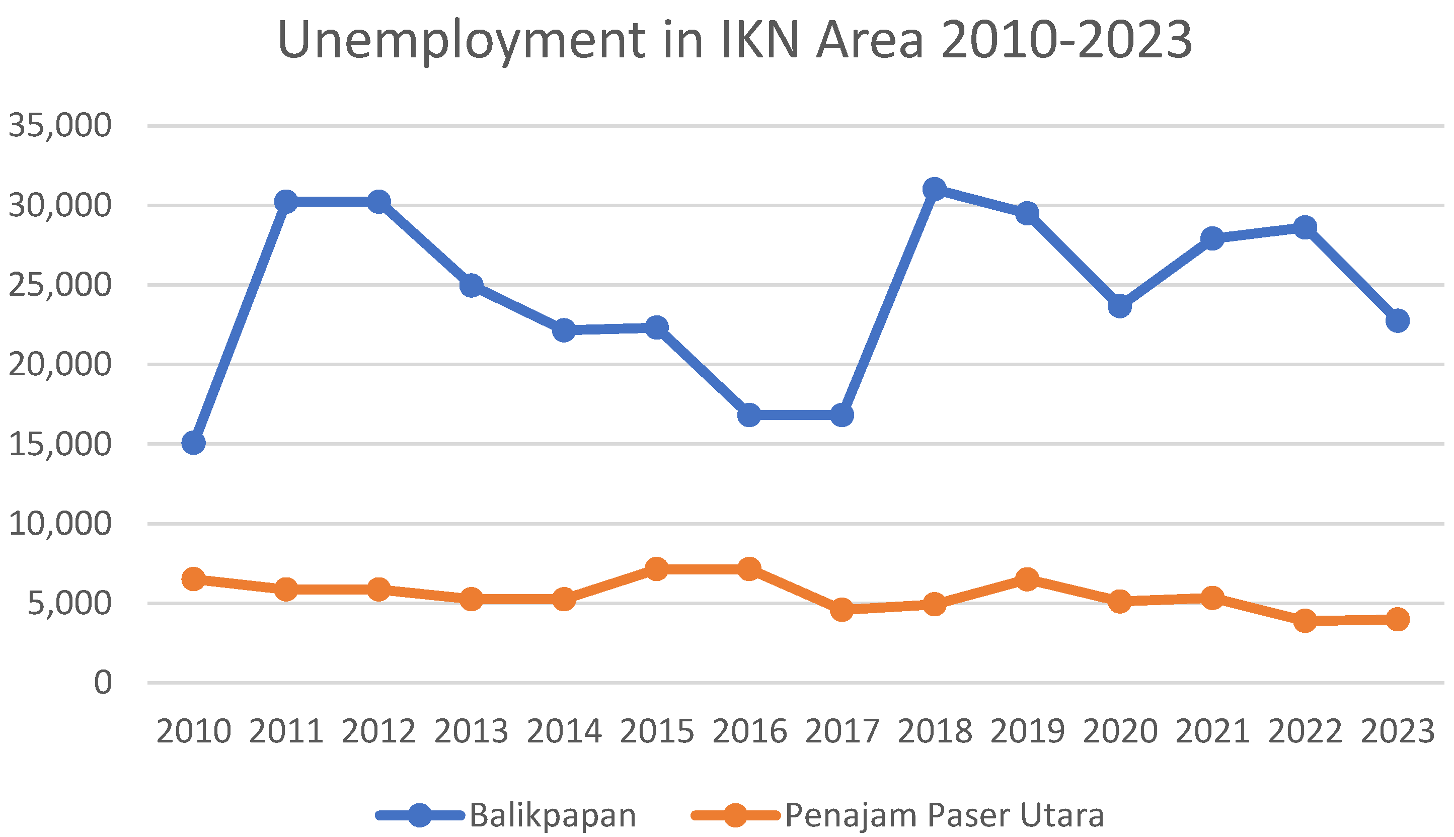
Figure 13.
Unemployment in IKN Area 2010-2023; Source: Adapted from BPS (2024).
Figure 13.
Unemployment in IKN Area 2010-2023; Source: Adapted from BPS (2024).
The disproportionate burden significantly impacts unemployment rates in the IKN area, particularly in Balikpapan and Penajam Paser Utara. The graph elucidates a comprehensive perspective on the labor market dynamics within these areas. In Balikpapan, notable fluctuations are observed, with unemployment peaks reaching approximately 30,000 individuals, contrasting with PPU’s relatively stable and significantly lower unemployment figures. This variance may reflect the diverse economic structures of the two areas, with Balikpapan potentially leaning towards an industry-oriented sector and PPU focusing more on the agriculture and forestry sectors. The volatility in Balikpapan’s unemployment rates could be attributed to several factors, such as shifts in global economic conditions, commodity price fluctuations, or industrial policy changes. The higher and more volatile unemployment rates indicate potential economic instability, which could heighten the risk of social dissatisfaction and economic conflicts, especially if a portion of the population feels marginalized from the economic benefits generated. Conversely, PPU, with its lower and stable unemployment rates, might face different challenges. Although this stability reflects a more balanced labor market, it suggests that PPU’s economy is less dynamic and rapidly evolving than Balikpapan’s. This situation could impact PPU’s capacity to absorb new labor or provide opportunities for its residents, potentially prompting migration to Balikpapan or other areas in search of employment.
Establishing the new capital brings about high hopes for job creation and investment attraction, which could potentially decrease unemployment rates. However, it is crucial to ensure the proper management of investments and equal distribution of benefits to avoid potential conflicts. The competition for jobs in the area may increase between locals and newcomers, causing social tensions if the former believe they need to receive adequate benefits. The economic pressures and conflicts that may arise from developing a new area can impact local communities differently (Chen & Vanclay, 2021; De Weger et al., 2018; Ma et al., 2020). Balikpapan’s data suggests high or fluctuating unemployment levels indicate a mismatch between the available workforce and job opportunities. This economic strain may intensify when the unemployed population lacks income sources, leading to heightened social anxiety and possible conflicts among individuals vying for limited employment opportunities.
Perceptions of unequal distribution of economic opportunities and development outcomes can fuel economic conflict. If investments in new capital are seen as benefiting only a select few or not benefiting local communities, it can lead to dissatisfaction and feelings of injustice (De Weger et al., 2018). To prevent social tensions and conflicts, residents need to receive a fair share of growth and opportunities from the development. Uncontrolled growth can strain local infrastructure, including housing, transportation, and public services, leading to declining living standards and increased economic and social pressures. Developing new capital may also result in rapid changes in the labor market, with new industries emerging and old ones disappearing. This can create a skills mismatch, where the local workforce needs more qualifications or training, increasing unemployment and economic stress (Aiyar & Ebeke, 2019; Krishnaveni & Anilkumar, 2022; Perveen et al., 2017).
5. Discussion
5.1. Socio-Economic and Environmental Dynamics of Urbanization in the IKN Nusantara Region
A marginal decrease in the Gini Coefficient, coupled with a steady Gross Domestic Product (GDP) growth, suggests that the areas surrounding the new capital have been relatively successful in dispersing the fruits of economic growth among their population. However, comprehending the nuances of this distribution is critical. While the Gini Coefficient indicates a reduction in income inequality, it does not necessarily reflect the full spectrum of economic disparities that may occur across different sectors or areas. The poverty reduction aligns with these indicators, suggesting that, to a certain extent, the rise in GDP has translated into improved living standards for impoverished communities.
Population growth during this period, a hallmark of developing nations such as Indonesia, must be contextualized within accelerated urbanization, as evidenced by the doubling of developed land’s expanse. This reflects a global trend wherein economic opportunities in urban centers draw populations away from rural areas. The ramifications of this shift are multifaceted, touching on social, economic, and environmental aspects. Rural depopulation, a consequence of urban migration, impacts agricultural production and traditional lifestyles. Nonetheless, the gradual elevation in the Human Development Index suggests improvements in overall well-being—including education and health—although these benefits warrant scrutiny to ensure equitable distribution across urban and rural communities. The environmental impact of economic expansion is palpably manifest in land-use data and deforestation figures. The marked reduction in agricultural land and vegetation signals potential challenges to biodiversity and the sustainability of agriculture. While deforestation has declined since its apex in 2014-2015, the loss of forest areas remains a significant concern for carbon sequestration, water management, and habitat conservation. An increase in wetland areas may reflect positive conservation efforts or natural adaptation to environmental changes. Nevertheless, the trade-off between ecological protection and land required for development necessitates judicious deliberation.
The socio-cultural implications of land use changes are profound, particularly for indigenous and local communities whose lifeways and economic sustenance often clash with national development agendas. Urban expansion and infrastructural developments have prompted community displacements and cultural landscape transformations. While this may pave the way for modernization and economic growth, it raises questions about preserving cultural identity and traditional practices (Sangha, 2020; Santini & Miquelajauregui, 2022a). Thus, Indonesia’s development narrative strives to balance advancing the economy with environmental stewardship, embracing modernity with safeguarding cultural heritage, and bolstering the national economy with equitable wealth distribution. On the one hand, progress towards a more advanced economy has elevated living standards, as reflected in rising per capita income and declining unemployment rates. However, on the other, it necessitates substantial land transformations with profound implications for the country’s ecological future and the well-being of its people. The country’s path forward requires a judicious policy synthesis, where economic ambitions are aligned with the imperatives of preserving natural environments and upholding Indonesian society’s social and cultural order (Andani et al., 2022; OBG, 2021; Terra dos Santos et al., 2023).
The transition of land use from forest and agricultural areas to urban development is a significant driver of socio-economic transformation. The expansion of built-up areas in Indonesia, with the conversion of forests and farmland into urban landscapes, alters the area’s economic foundation, accelerating the shift from an agrarian economy to one focused on industry and services. This urban-centered economic growth often offers higher income potential and more diverse job opportunities, attracting populations to urban areas. However, this transition can also reduce food security due to decreased arable land, compelling reliance on imported goods, and altering local food systems. This issue transcends economic dimensions, touching upon cultural identity, as agricultural practices are intertwined with the cultural fabric of rural communities.
For Indigenous and local communities, the conversion of ancestral lands for other uses, mainly deforestation, not only disrupts their subsistence but also erodes their cultural heritage and traditional knowledge. Such land appropriation fractures social structures detaches communities from their spiritual sites and erodes cultural practices—including language, rituals, and crafts—crucial for the transmission of cultural identity (Busch & Amarjargal, 2020; Kumar Yadav, 2023; Santini & Miquelajauregui, 2022b). The diminishing access to natural resources increases their vulnerability, as many rely on forests for hunting, gathering, and traditional agriculture—practices that have sustained biodiversity for generations. Urbanization often forces a shift to wage labor, which may be inaccessible or unsuitable for these populations, exacerbating poverty and marginalization (Busch & Amarjargal, 2020; Redvers et al., 2023; Tofu et al., 2023). This scenario calls for policies promoting sustainable land use, ensuring economic development does not come at the cost of environmental degradation and cultural dissolution. This includes recognizing the land rights of Indigenous and local communities and integrating their knowledge and practices into national conservation strategies. It is a plea for development that respects the limits of the natural environment and the rights of its centuries-old stewards.
5.2. Economic Development and Land Use Transformation in IKN Nusantara
The growth in GDP signifies a positive trend in economic development, yet the reduction of agricultural land from 569.56 km² in 2003 to 436.105573 km² by 2023 signifies an economy in transition. Correspondingly, doubling built-up areas to 171.354009 km² indicates a shift toward urbanization. This urbanization potentially diversifies employment opportunities, contributing to a significant decrease in unemployment from 30,224 to 22,749. Nonetheless, this raises critical questions regarding the rural workforce’s readiness to transition to new urban roles and whether the displaced agrarian communities can reap the benefits of urban employment.
Furthermore, the expansion of wetlands from 290.52 km² to 396.500204 km² may reflect successful environmental conservation efforts, crucial amidst decreasing vegetation cover. While seemingly minimal, the slight reduction in vegetation area from 1,769.05 km² to 1,712.46704 km² should not be underestimated as it likely signals ongoing deforestation. The consequences of such deforestation are far-reaching, affecting not only environmental aspects such as biodiversity and climate but also socio-economic factors, including job security in the forestry sector and the availability of natural resources vital for many communities’ survival and cultural practices.
Moreover, while increases in per capita income and the Human Development Index (HDI) may reflect an improvement in macroeconomic conditions, these indicators do not directly translate into the well-being of agrarian communities and indigenous populations displaced from their lands. The decrease in poverty levels is a positive sign; however, the relationship between this decline and the loss of traditional agricultural lands warrants further scrutiny. It is crucial to explore how socio-economic transitions from land-based traditional industries to an urban, service-oriented economy impact not only the financial but also the social fabric of the nation. For many indigenous communities, land is not merely an income source but a core component of their identity and lifestyle. Hence, land-use changes carry implications for preserving cultural diversity and social cohesion (L. Liu et al., 2023; Ninomiya et al., 2023).
Although socio-economic indicators signal signs of a robust national economy, fundamental shifts in land use and their impacts on food security, employment types, and cultural continuity suggest a more intricate scenario. This complexity demands policies and initiatives sensitive to the needs for economic growth while safeguarding Indonesia’s rich environmental and cultural heritage.
5.3. Conflict Resolution
Accelerated economic growth and land-use transformation necessitate an inclusive and participatory governance approach to ensure the integration of indigenous communities, local populations, business entities, and civil society groups into decision-making processes. Effective governance is pivotal in identifying and resolving land-use conflicts—be it for development or conservation purposes. These conflicts often pertain to land rights and resources, with indigenous and local communities frequently at the forefront, suffering from loss of access to land and resources that are essential to their identity and livelihoods.
5.4. Inclusive Dialogue and Reconciliation
Resolving tensions stemming from land-use transformations in the Nusantara IKN area requires a commitment to inclusive political dialogue and reconciliation. It is critical to engage diverse stakeholders, encompassing those directly impacted by land changes, local governments, civil society, and groups often marginalized in such discussions, such as women, youth, and indigenous populations (Long et al., 2021; Rahimi, 2016). A dialogue platform should allow for the equitable and safe exchange of perspectives, acknowledge past grievances, and explore pathways toward autonomy and self-management. The facilitation by impartial experts in managing sensitive and complex dialogues is crucial. Integrating traditional conflict resolution methods with contemporary approaches can enhance the credibility and acceptance of these processes. Such an integrated strategy fosters reconciliation and respects cultural heritage while embracing local insights and current best practices to ensure equity and inclusiveness (Lorenzini et al., 2017).
5.5. Human Rights Restoration and Socio-Economic Development
Protecting human rights is fundamental in addressing conflicts and fostering sustainable peace in areas affected by land use changes. Accountability for past human rights violations is crucial, ensuring justice for victims and sanctions for offenders. Forming independent bodies to oversee and rectify human rights infringements is essential, as is aligning national laws with international human rights norms. Such measures bolster confidence in the legal and governmental systems, which are crucial for societal harmony and stability (Gilbert, 2013; Rishmawi, 2019). Moreover, addressing the root causes of conflict through socio-economic development is vital. Poverty, unemployment, and inadequate service access often exacerbate land use conflicts. Tailored economic initiatives focusing on inclusion and sustainable development, like job creation and enhancements in infrastructure and services, can elevate living standards and maintain a peaceful milieu respectful of rights (Fagbemi & Fajingbesi, 2022; Mueller & Techasunthornwat, 2020).
5.6. Enhancing Public Participation
Amplifying community engagement in developmental and conservation initiatives within the Nusantara IKN area is pivotal to ensuring such endeavors’ broad benefits rather than exclusive gains for a select few. Integrating local perspectives and wisdom, particularly from those whose livelihoods are intertwined with landscape changes, enables the tailoring of environmentally considerate development plans that respect indigenous rights. Such a participative approach, enacted at every phase from planning to execution, ensures community endorsement and fosters collective responsibility. Active public involvement empowers citizens to impart crucial insights, which is particularly vital when indigenous lands are repurposed. It also facilitates melding traditional knowledge with contemporary conservation techniques, engendering innovative developments that honor historical practices. This synthesis of the new with the venerable assures collective stewardship over natural resources, entwining environmental preservation with societal progress (Arsenault et al., 2019; Brittain et al., 2021; Reyes-García et al., 2024). Fostering community participation further democratizes developmental dividends, enhances social equity, and mitigates conflicts. Seeing their contributions reflected in developmental outcomes, community members are likelier to support and sustain these initiatives. In essence, meaningful community participation in the IKN Nusantara transcends merely providing a platform for voicing opinions; it is about weaving those voices into the tapestry of development that respects the past while innovating for the future (Bell & Reed, 2021; Botes & van Rensburg, 2000; Tembo et al., 2021; Tremblay et al., 2018).
