2. Materials and Methods
The history of geological research in Kazakhstan is rich and fascinating, from ancient times to the present day. Geological phenomena and their impact on the environment have been studied since ancient times. The ancient inhabitants of Kazakhstan, such as the Scythians and Sarmatians, made observations of geological processes and used rocks for structures as well as tools. In the 19th century, geological research in Kazakhstan began due to the interest in the natural resources of this vast territory. In the 1920s and 1930s, the first comprehensive geological expeditions were conducted, as a result of these early studies large deposits of oil, gas, metals and other minerals were discovered. This period was also marked by the creation of geological institutes and university departments, which became the basis for subsequent research and training of specialists. In the post-war years, geological research in Kazakhstan continued as part of industrialization and the development of new territories. New mineral deposits were discovered, research was conducted in the field of hydrogeology, engineering geology and other areas. Currently, geological research in Kazakhstan is an important component of the development of the country's economy. Modern technologies and research methods are being utilized in comprehensive studies on the exploration and evaluation of mineral deposits, geological structure; and assessment of seismic risk. Geological research in Kazakhstan is carried out by both public and private companies, as well as with the participation of international organizations and institutions. These studies play an important role in the development of the economy, science and environmental protection of this country.
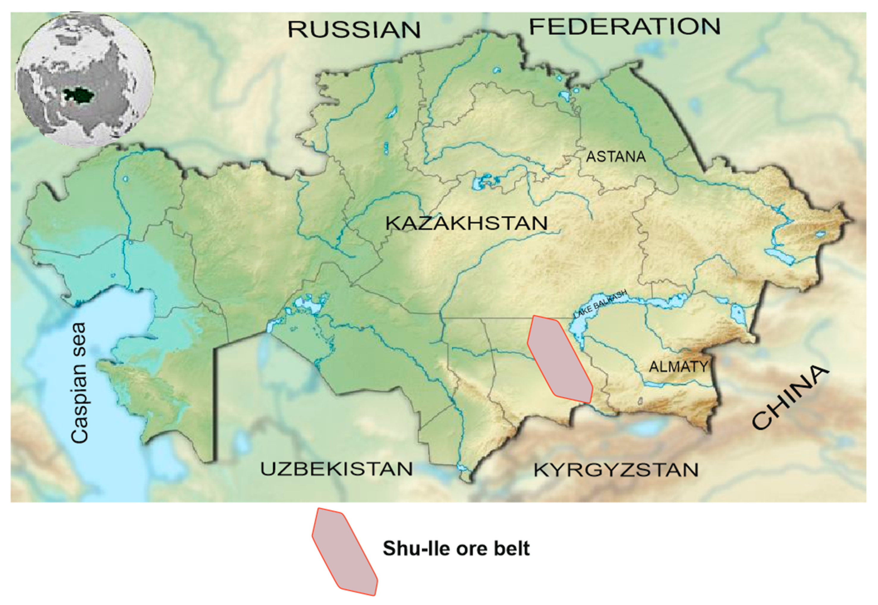
Durin the development of the Shu-Ile region (
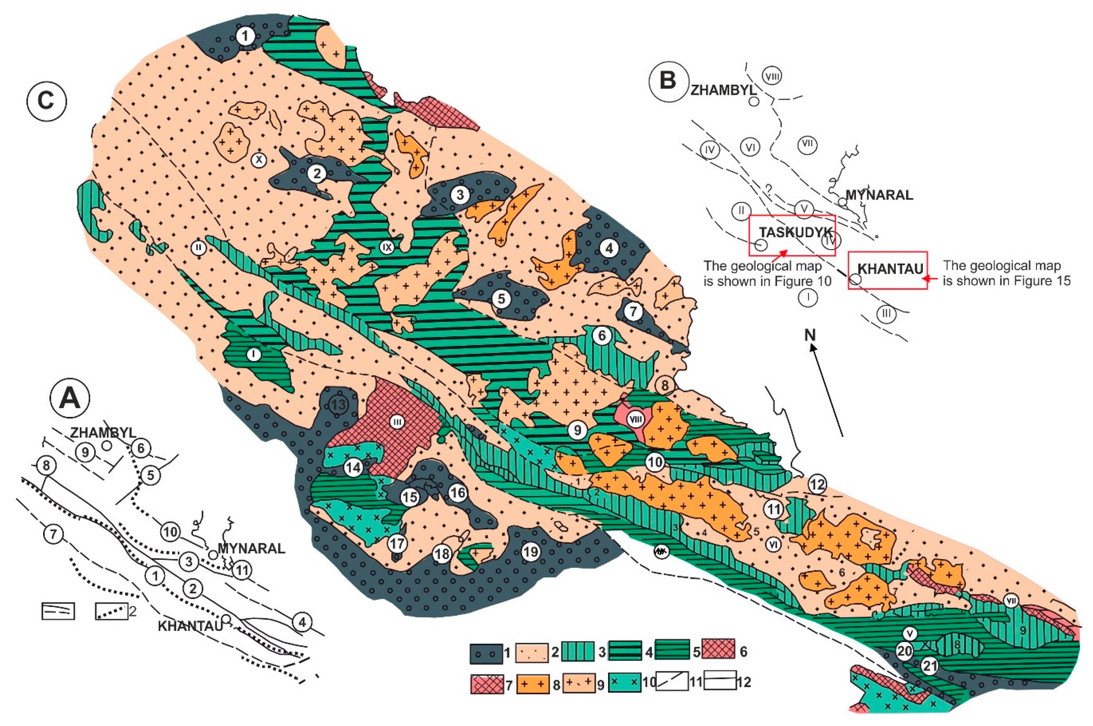
Figure 1), the earliest igneous rocks are represented by plagiogranite and granite gneisses, manifested in individual protrusions of the Paleoproterozoic continental crust (e.g. Shu and Kendyktas, Buryltas anticlinorium, and the Anrakhai horst). Early sialic magmatic evolution is fixed by the sodium granitoid replacement (plagioclase) with potassium-sodium (K-spar-plagioclase), then significantly potassium (K-feldspar) and are oriented in the same orientation as the Early Precambrian structures enderbite-charnockite-leucogranite series (Mitrofanov et al., 1975), but it is distinguished by the high-temperature absence and dry mineral paragenesis. This may be due to the Paleoproterozoic granite formation development at a depth no greater than amphibolite facies conditions and/ or subsequent diaphthoresis. Granitoids form complex polygenic massifs, mainly in contact with dynamically recrystallized structures. Most of them contain palingenic-metasomatic features (relict-shadow structures, and skialites), conformable occurrence, gradual transitions into host metamorphic rocks.
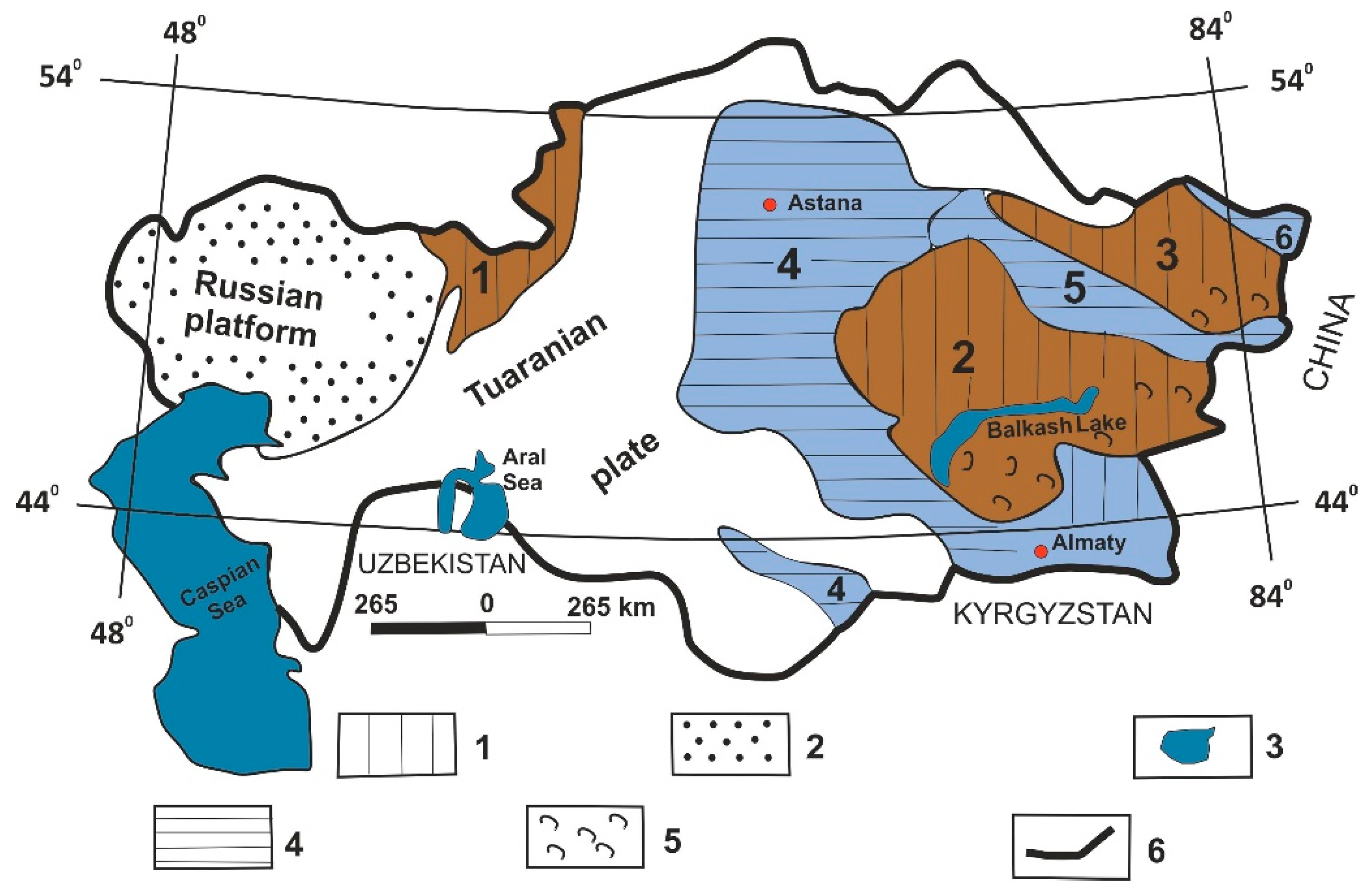
Paleoproterozoic granitoids arose magmatically, but subsequently underwent dynamic recrystallization, cataclasis However, judging by the pebbles of Ordovician conglomerates, there were also non-foliated leucocratic granites. Location of the JBFS (Jungar-Balkhash Fold System) in the Central Asian Orogenic Belt is shown on (
Figure 2) [
46].
Paleoproterozoic granitoids form narrow linear belts (Kerbulak, Sarybulak massifs) in an amphibolite-gneiss-schist frame or linear fragmented tectonic blocks (Karasai, Buryltau and Kundyz massifs) in weakly metamorphosed Paleozoic strata. The linear belts of Paleoproterozoic granitoids result from emplacement along the northwestern-striking (300-320°) deeply rooted fault zones, consistent with Jalaiyr-Naiman zone direction [
27].
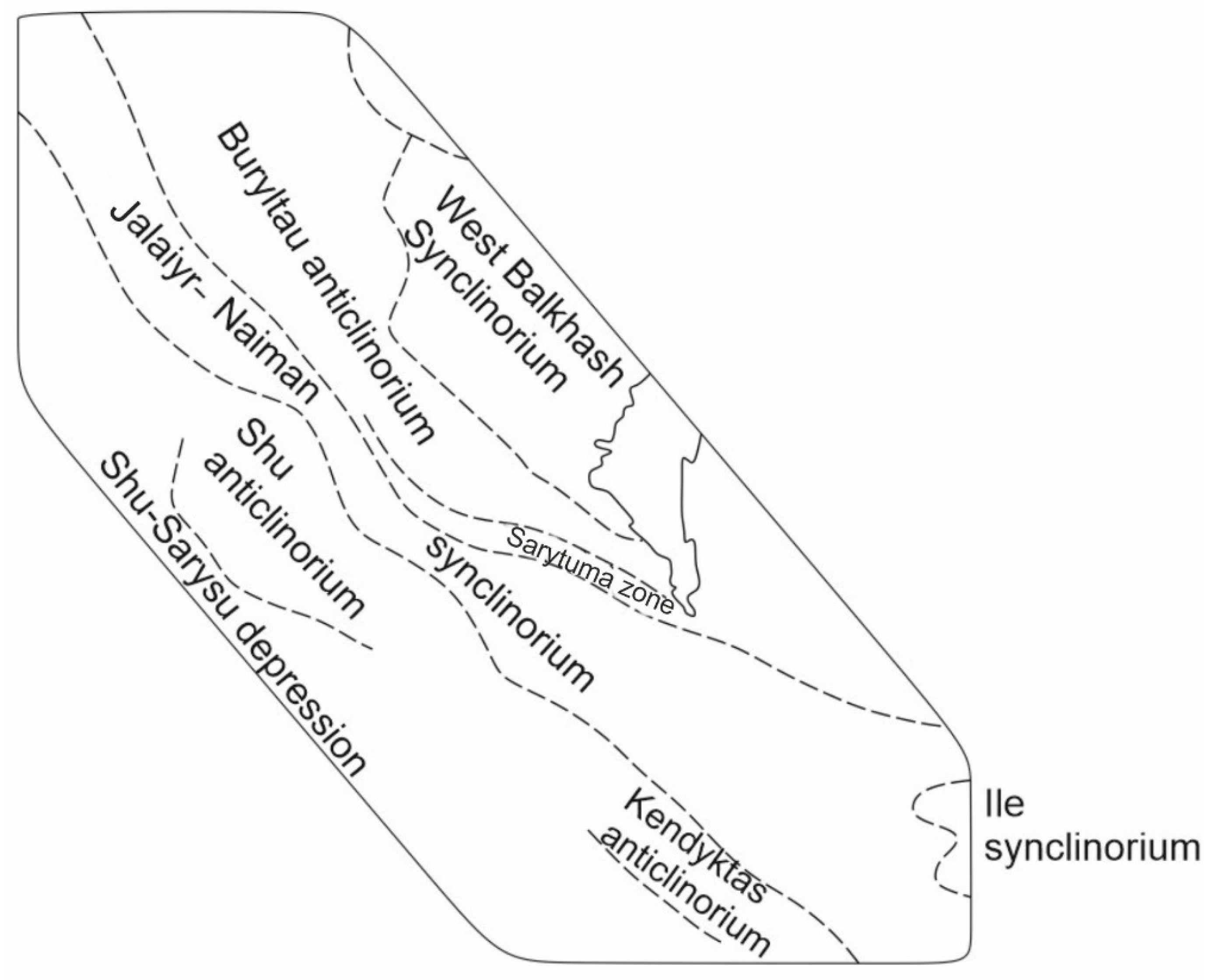
Basaltic volcanism occurred in the Neoproterozoic and Ediacaran. Neoproterozoic volcanic sequences crop out locally in the Shu, Kendyktas anticlinorium, and the Jalaiyr-Naiman synclinorium. The main Ediacaran and Lower Cambrian volcanism is typical for the Jalaiyr-Naiman synclinorium. Neoproterozoic volcanism, marking the beginning of the middle massif destruction, evolved from the tholeiitic series basalts to liparites and dacites. The volcanic rocks belong to the calc-alkaline series and are characterized by oversaturation with low alumina and low magnesium content. In the Lower Cambrian, basaltic volcanism occurred in the Sarytuma area. The main volcanism appeared on a limited scale in the Middle Cambrian in the Sarytuma zone, and in the Upper Cambrian in the Jalaiyr-Naiman synclinorium (
Figure 3).
In the Jalaiyr-Naiman synclinorium, the beginning of the early stage after destruction and following the basalt-andesite-liparite formation is reflected by spilite-diabase volcanism, typical of rifts. Thus, early-stage basaltic volcanism manifested itself in several (at least three) episodes. The greatest intensity and basaltic volcanism episodes are characteristic of the Sarytuma and in particular, the Jalaiyr-Naiman zones of deeply rooted faults. In the last zone, basalts and basaltic andesites show contrasting differentiation and increased alkalinity with a high sodium predominance over potassium, some of them are enriched in magnesium and depleted in free lime. The most important stage in Shu-Ile region development is marked by gabbro-hypermafic formations, represented by dunite-harzburgite, dunite-diallagite-gabbro and spilite-diabase formations, magmatic emplacement age of which date back to the Lower Cambrian [
29,
31].
In their modern occurrence, gabbro-hypermafic rocks massifs represent outliers of the metabasaltic layer, injected tectonically. We infer that since the early Paleozoic (and possibly earlier) there was a long but intermittent rise in gabbro-hypermafic masses along the Jalaiyr-Naiman zone of deeply rooted faults. Prior to movement along the Jalaiyr-Naiman zone, mantle material went through a complex path of development within individual chambers and during subsequent magmatic intrusive events, as evidenced by the differentiation of magma from peridotite komatiite to oceanic basalts. Gabbro-hyperbasites widespread development, which are apparently older in Shu-Ile region tectonically active formation, indicates ruptures and stretching of the crystalline basement and the manifestation of “tectonically rifted” collapses. The mechanism of local rifting is associated with the Paleozoic mantle plume activity, under the pressure of which local tectonic unloading conditions, extension and decompression were created in multidirectional vertical movements of deep faults, and a counterbalance to them in the conjugate blocks was created by stressed thermodynamic conditions. During the subsidence and uplift of the Shu-Ile zone, marine and continental environments existed, respectively. In such a contrasting geodynamic environment, igneous and metamorphic formations of the corresponding tectonomagmatic formations formed [
5,
9,
14,
17,
19].
Gabbro-hypermafic mass squeezing and brecciation in connection with active tectonic movements, which manifest themselves repeatedly from the early to late Paleozoic, occurred as a result of movement along the Jalaiyr-Naiman fault zone. Basic volcanism occurred continuously until the mid-Devonian and was synchronous with marine sedimentation. These volcanic rocks, include; spilite-diabase, andesite-basalts of the Aschysu, Sulusai, Buryltas, Jalgyz and other formations). Outside the rifts, they are deposited synchronously with terrigenous sedimentation. Sodium alkalinity early basalts were replaced by gabbro-plagiogranite formation, fully established in the Sarytuma zone [
29].
In the Late Ordovician, in the Shu-Ile region and other structures of Kazakhstan, a tonalite-plagiogranite formation formed and is confined to internal tectonic uplifts and middle massifs. This deformation marks the beginning of a new inversion during the Caledonide orogeny development and the descending movement replacement by ascending, compression and thrust dome-block dislocations. The tonalite-plagiogranite formation reflects the intense sodium metasomatism development in the earth's crust deep zones and the metadiorite layer formation.
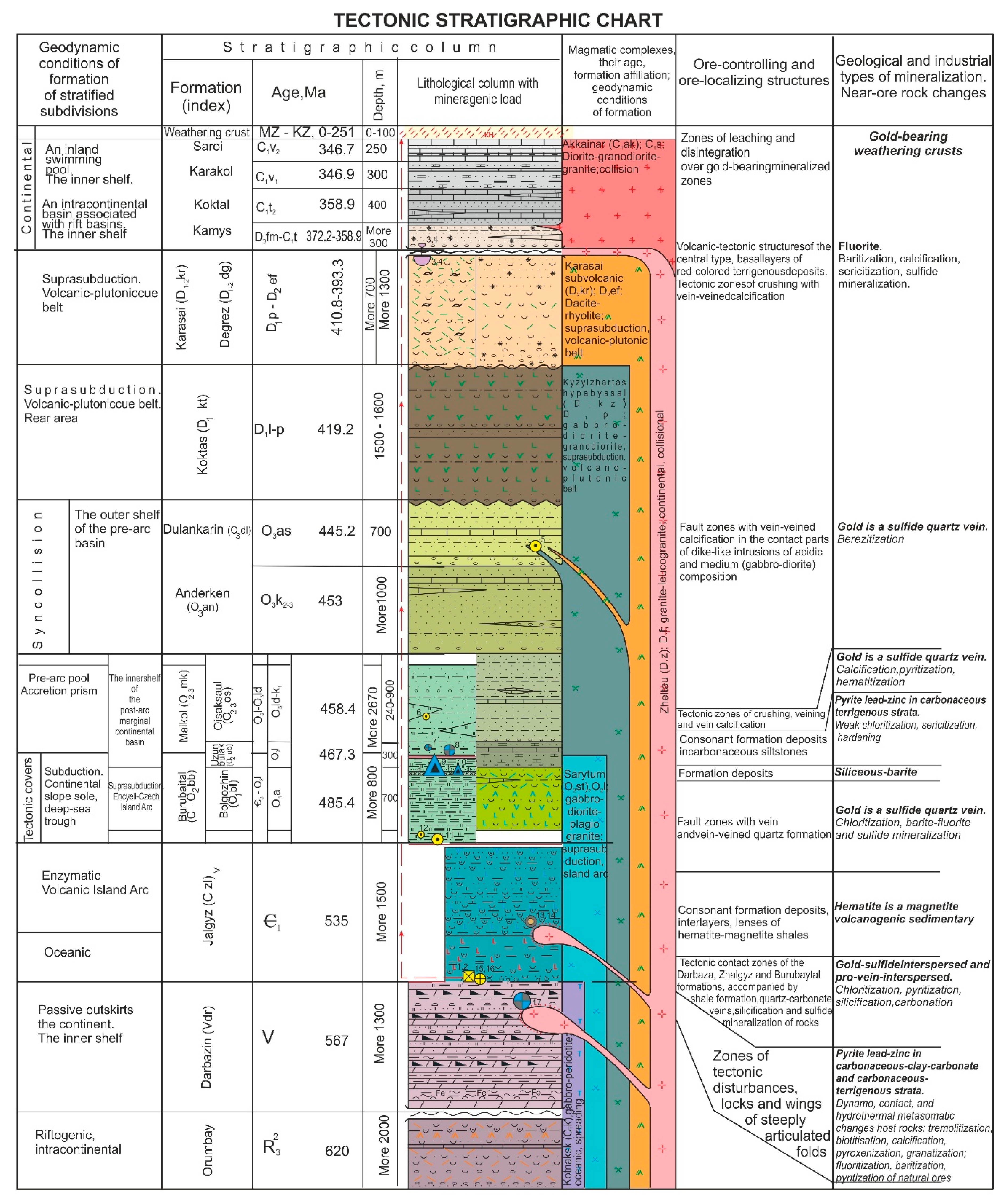
At different crustal levels, the manifestation of this formation varies. Within the amphibolite facies, plagiogranitoids participate in the polygenic pluton composition of autochthonous and allochthonous nature. Complexly structured polygenic plutons, located in amphibolite grade -gneiss and schist host rocks which form linearly extended chains along deeply rooted faults. These rocks are typical of the Kendyktas anticlinorium. It should be noted that, probably, the Upper Ordovician plutons of Kendyktas are typically intruded and composed of rocks of three phases: Phase I - gabbro, diorites; II - syenodiorites, granodiorites; III - granites, leucogranites. At intermediate depths, the tonalite-plagiogranite formation is manifested in allochthonous plutons form of sub-conformable occurrence and is subject in areas to later potassium-sodium and potassium metasomatism, as a result of which in isolated massifs transitions of plagiogranitoids into granodiorites-granites and syeno-granodiorites-granosyenites are observed at significant variations in radiochronological dating values (Kendyrlyk and Kiiktas massifs of the Shu anticlinorium). Along Buryltas axial part anticlinorium, the tona-lite-plagiogranite formation forms small intrusions of intermediate-depth facies (Zhalpaktas and others), subject to uneven porphyroblastic K-feldspathization under the Devonian granitoids influence. It should be emphasized that the Upper Proterozoic granitoids of the Anrakhai, Karakamys, Sarybulak, Kerbulak, Karasai and Kundyz blocks underwent repeated feldspathization processes, which complicated the original mineral paragenesis and influenced the determination of age (
Figure 4 and
Figure 5).
Devonian granite formation is qualitatively different from the previous one in terms of increased alkalinity and potassium-sodium ratio. The alkali content in granitoids increased from 6 to 7.5%, and the potassium-sodium ratio - from 0.3-0.5 to 0.9-1.1. In parallel with the increase in total and potassium granitoid alkalinity of different ages, their silicic acid content increased from 60 to 72.5% [
3,
4].
In the interval between the Late Ordovician and sialic magmatism Early-Middle Devonian stages, of normal calc-alkaline andesite-basalt formation and tholeiitic types was formed (Koktas complex). In some isolated pockets, the andesite-basalt formation has a subalkaline slope and shows contrasting differentiation to the trachyparite level.
The comagmatic continental liparitic and granite formations that followed the andesite-basaltic volcanism accompanied uplift of the region. The liparitic formation is manifested by local volcanic centers in the Shu anticlinorium and the Anrakhai horst and has an aerial development in the Jalaiyr-Naiman and Western Balkhash synclinoriums [
33,
34]. The granite formation is widely represented in all structures of the southwestern side, except for the Jalaiyr-Naiman synclinorium and the Sarytuma zone, and forms linearly extended belts in the Shu, Kendyktas, Buryltau anticlinoriums, and arc-shaped semi-ring areas in the West Balkhash synclinorium. The manifestation form of the granite formation varies somewhat in different structures. In general, these are extended, slightly arcuate belt-chains, obliquely oriented relative to the Jalaiyr-Naiman zone strike. Granitoid plutons were formed at intermediate depths and are linearly elongated conformable occurrence laccoliths, the intrusive chambers of which arose through relative frame block vertical movements limited by longitudinal northwestern and transverse northeastern fault systems.
In different structures, rock petrochemical variations are exist, and likely caused by the focal region unequal composition, different depths of pluton formation, different levels of their erosional exposure, formation in a different type of geological frame and different degrees of post-magmatic processes manifestation (in particular, K-feldspathization). For many plutons, vertical intrachamber differentiation of alkalis is typical, associated with an increase in alkalinity and granite potassium content in the upper zones relative to the lower ones. The most leucocratic granites with high alkalinity are found in massifs occurring among acidic rocks. In a single belt, granites of weakly eroded massifs are more alkaline and potassic than those within deeper eroded massifs.
The granite formation Late Devonian stage of the Caledonian cycle, which occurred at the regressive stage of granite-forming processes in the earth's crust deep zones, caused potassium granites formation, which has a pronounced polyfacial composition and is represented in different zones by various petrochemical types (subformations).
A small gap between the Early-Middle Devonian and Late Devonian stages of granite formation is recorded by the formation of subalkaline basaltoids, manifested only in the Jalaiyr-Naiman synclinorium. During the same period, Karasai complex gabbro-monzonites, monzodiorites, and syenogranodiorites formation.
In the Western Balkhash synclinorium, the potassium granite formation is represented by alkaline leucogranites that form shallow central plutons (Taiatkan, Shunak, Kyzyltas, Kosshoky, Western Atasu) and subalkaline leucogranites (Ortangytau) in the form of stock-shaped bodies. Alkaline leucogranites and leucogranites belts, like the Middle Devonian granitoid belts, have an elongated arc-shaped orientation.
In the Jalaiyr trough, potassium granites are represented by subalkaline leucogranites, subintrusive facies granosyenite and trachyliparite porphyries, forming small domes, stocks, sheet, and dike bodies among the trachylyparite-comendite strata southeast of the Jeltau pluton.
In the Shu anticlinorium, potassic leucogranites oversaturated with alumina with a K2O content of up to 8 % are developed, forming subvolcanic bodies in the Devonian volcanic-sedimentary sequence. Normal and subalkaline leucogranites in the central pluton form of the mid-depth facies are typical for the Kendyktas anticlinorium.
A single formation of potassium granites is represented by several petrochemical types, located zonally. From the Jalaiyr-Naiman zone in the northeast direction there is a change from less alkaline, but more potassium facies (leucogranites) to more alkaline and sodium ones (alkaline leuco-granites). A similar zonation is recorded in the southwest Jalayir-Naiman zone. Late Caledonian granite formation culminated in a series of mid-basic dike belts along submeridional, northeastern and northwestern fault bands.
Hercynian deformation is marked by regional subsidence that led to the development of an aerially extensive shallow-marine environment and persisted in isolated basins in the Upper Devonian-early Carboniferous (in the Mikainar, Kashkanteniz, Karakamys, Duanynsor, Matuktyubek and other troughs). Carbonate-terrigenous strata D3fm-C1t contain clasts of subalkaline basaltic or basalt-trachyliparitic volcanism, similar to the Atasu region (tuffs, ). In the Shu-Sarysu depression, lavas and tuffs of picritic basalts were discovered by drilling. From the Middle Carboniferous, the Late Hercynian tectono-magmatic activity intensified. In the southeast of the Shu-Ile region, the activity is characterized by abundant volcano-plutonic nature, in the north-west it was plutonic.
Middle stage Hercynian magmatism begins with comagmatic andesitic (C
2-3) and sodium alkalinity diorite formations, by the beginning of Shu-Ile region formation was already a partially eroded massif. The subsequent dacite-liparite-granite volcano-plutonic formation manifested itself in disconnected volcano-tectonic structures that arose at the junction of northwestern, sublatitudinal and submeridional fault systems. The further magmatic activity occurred within the volcano-plutonic structure framework was laterally centripetal in nature, as a result of which increasingly younger magmatic formations shifted inside individual ring structures and calderas. In the Lower Permian, new basaltic magmatism caused comagmatic trachyandesite-trachybasalt formations mainly in the subvolcanic facies and monzonite-syenodiorite formation, after which the trachyparite-granosyenite formation appeared in the central ring type longest-lived calderas [
37,
38,
39].
In the north-west of the Shu-Ile region, Hercynian magmatism is manifested in the plutonic facies and begins with Early Carboniferous plagiogranites, represented by small massifs in the West Balkhash synclinorium southern side, and ends with Permian leucogranites of the Akshatau type (
Figure 6). In the interval between sodium granites and potassium alkalinity, the monzonites formation and Kokdombak syenodiorites complex separated [
34].
Shu-Ile zone Hercynian magmatism is generally characterized by andesite-basalt multi-stage alternation and liparite-granite magmatism with a natural increase in the total and increasingly younger igneous rock potassium alkalinity. Andesite-diorite and liparite-granite formation types are genetically autonomous, and their structural combination reflects the vertical migration of the magma formation front from the metabasaltic layer to the metadiorite and metagranite.
A. Diagram of the main faults (in the lower left corner): 1 - solid line - reliable faults, dotted line - according to geophysical data, 2 - contours of the main structures. Faults (figures in circles): 1, 2 - Zhalayyr-Naimansky (1 - southern, 2 - northern branches), 3 - Sarytuma, 4 - Anyrakhai, 5 – Bektauata, 6 - Atasu, 7 - Shu, 8 - Kosaryk, 9 - Shalgin, 10 - West-Balkhash, 11 - Balkhash.
B. Scheme of structures of the first order: I - Shu-Sarysu depression, II - Shu anticlinorium, III - Kendyktas anticlinorium, IV - Jalaiyr-Naiman synclinorium, V - Sarytum zone, VI - Buryltau anticlinorium, VII - West Balkhash synclinorium, VIII - Atasu-Moiynty anticlinorium.
C. The scheme of the distribution of tectonic complexes and the placement of structures of the second and higher orders. Tectonic complexes: 1 – Famen-Carboniferous; 2 - Early Devonian-Fran; 3 - Early Paleozoic (Darrivil-Silurian), 4, 5 - Flo-dapine (4) and Neoproterozoic-Cambrian-Tremadoc (5), 6 - cover of the Epicarean platform (Mesoproterozoic), 7 - foundation of the Epicarean platform (Early Precambrian), 8 - granitoid intrusions of Permian, 9 - granitoid intrusions of the Late Devonian, 10 - granites, granodiorites, gabbro of the Middle-late Ordovician, 11 - contours of structures of the first order, 12 - contours of structures of high orders.
Basalts, andesite-basalts and andesites and comagmatic gabbro-diabases, gabbro-diorites, diorites are located in the field of tholeiitic basalts (except for volcanics of the Jalgyz formation) and belong to the hypersthene series of rocks. Compared to comagmatic plutons, intermediate basic composition volcanics are more enriched in silica, titanium, alkalis and somewhat depleted in aluminum, calcium, and magnesium oxides. Consistently, from early to middle igneous rocks and then to late ones, the fractionation coefficient (iron content of rocks) increases. The belonging of igneous rocks to contrasting series is indicated by the values of the petrochemical Rittmann index exceeding 1 and reaching 8.7 in the rocks of the Jalgyz formation. The exception is the subcontinental andesites of the inversion stage, which belong to a successively differentiated series.
The late Caledonides and Hercynids formations and series are characterized primarily by liparite-granite and alkali-liparite- leucogranite composition. The SiO2 content is 72-75 %, and the most acidic rocks of the volcanogenic series are extrusive-subvolcanic varieties (automagmatic breccias and their comagmatic derivatives), which precede plutonic facies formation. Late-stage igneous rocks belong to a contrasting series of rocks. A tendency towards a decrease in the serial Ritman index in late igneous rocks is revealed, which reflects a greater increase in SiO2 relative to the alkalis sum. The stability of the aluminum-alkali index (alcal - 19.65-21.59) is due to an increase in alkali content with a simultaneous decrease in alumina. Late stage granites are close in composition to volcanics, differing in a slightly increased total alkalis content and a decreased calcium oxides content.
The alkalis ratio in igneous rocks of different ages changes naturally. In the Middle Ordovician gabbro-plagiogranite formation, sodium always dominates over potassium; in the Upper Ordovician polygenic diorite-tonalite-plagiogranite-granite the alkali ratio is variable. In general, the total alkalinity and granitoids Caledonian cycle potassium content increases over time (although there are deviations for albite granites). In the same direction, the SiO2 content increases and the MgO, FeO, Fe2O3, CaO content decreases. When one formation changes to another, the parameters of almost all oxides change contrastingly, while in the volume of a single series and formation type, the oxide contents decrease or increase more or less smoothly, although intraformational peaks are recorded, which are less contrasting than interformation peaks.
Variation lines of calcium, alkalinity, iron, silica and potassium content of different types of formations of the Caledonian cycle indicate their autonomy and reveal significant differences between them. The variation lines of silica and alkalinity of the Caledonian formations, on the contrary, are of the same type and indicate a gradual increase in these parameters as the rock decrease basicity. In terms of calcium content, quartz diorites-granodiorites D
1-2 are distinguished by a sharp increase in this parameter as the basicity of the rocks decreases, which indicates the large role of iron and magnesium at the magmatic process beginning. A characteristic is the calcium content constancy and the independence of this parameter from basicity in the diorite-tonalite-plagiogranite-granite formation of the Late Ordovician [
8].
Region igneous rocks of different ages and different facies are characterized by unequal geochemical specialization. The most ancient rocks of basic composition are distinguished by their positive concentrationin chromium, cobalt and scandium, as well as in molybdenum. Gabbro-diabases, in addition to molybdenum, contain high concentrations of lead, and hydrothermally altered basalt and basalts contain nickel. The geochemical differences between extrusive and hypabyssal rock varieties are also characterized by the low concentration of the latter for nickel and bismuth. Later andesitic volcanic rocks are high concentration for bismuth, scandium and gallium and low concentration for iron group elements and major elements.
Orogenic acidic igneous rocks of the region are concentrated in yttrium, ytterbium, tin, niobium, and zirconium. Effusives with an alkaline bias (trachydacites, trachyliparites) are positively concentrated in lead. Liparite extrusive porphyries (copper, molybdenum, tin) contain the largest amount of ore elements and are in high concentrations.
In conclusion, it must be emphasized that certain stages of the tectonic-magmatic development of the region are characterized by an igneous formation regular petrochemical profile. The early-stage products have a basalt-gabbro-diabase composition, the middle ones have an andesite-diorite-plagiogranite composition, and the late ones have a liparite-granite- leucogranite composition. The magmatism mafic profile with hypermafic rocks is an only Jalaiyr-Naiman zone characteristic, while the surrounding framing structures had a predominantly sialic or mixed mafic-sialic profile.
3. Results
Neoproterozoic carbonate-quartzite-schist complex (PR3). In Eastern Betpakdala, in the area of Akbastau, this complex includes the Akbastau and Borbas formations, composed of quartz-muscovite, quartz-albite schists, quartzites, and dolomite marbles. In the Atasu-Moiynty region it owns the Sulumonak and Taskoraly formations. The first is composed of metaterrigenous sericite-chlorite and quartz-sericite schists, in places carbonaceous, marbled limestones, the second is composed of blastopsammitic quartzites. The complex strata metamorphism corresponds to the greenschist facies, predominantly low-temperature. Quartzites often exhibit a relict psammitic structure; they are formed from quartz and high degree maturity quartz-feldspathic sandstones. Obviously, all these strata are formed from shallow sediments. The age of the strata is determined by their occurrence with structural and metamorphic unconformity on the ancient continental crust complex strata and the age of detrital zircon from the Borbas Formation of 1750 Ma and the uranium-lead age of the overlying porphyroids within the range of 800-950±50 Ma, like the early Neoproterozoic. The deformation structures of the complex were formed under lower mesozone conditions, which is determined by the regional metamorphism greenschist facies and the total layer-by-layer cleavage development, with the exception of the most deformation-resistant homogeneous quartzites and dolomites. Layer-by-layer cleavage deformations degree reaches higher tectonofacies and shear zone development with high displacement develop along layer boundaries of different competence. Large recumbent isoclinal folds are also characteristic, complicated at the hinges by small-scale folding. The hinges of large and small folds are parallel. Linearity is developed, oriented parallel to the fold hinges (
Figure 7 and
Figure 8). The deformation age is determined by the late Neoproterozoic structural and metamorphic unconformity, which marks, on a global scale, the formation of the Kazakhia continent after Rodinia supercontinent breakup. These structures are complicated by intersecting folds and Paleozoic age shear zone. In zones of large later steeply dipping sutures, sublayer structures are linear [
12,
29,
36,
45].
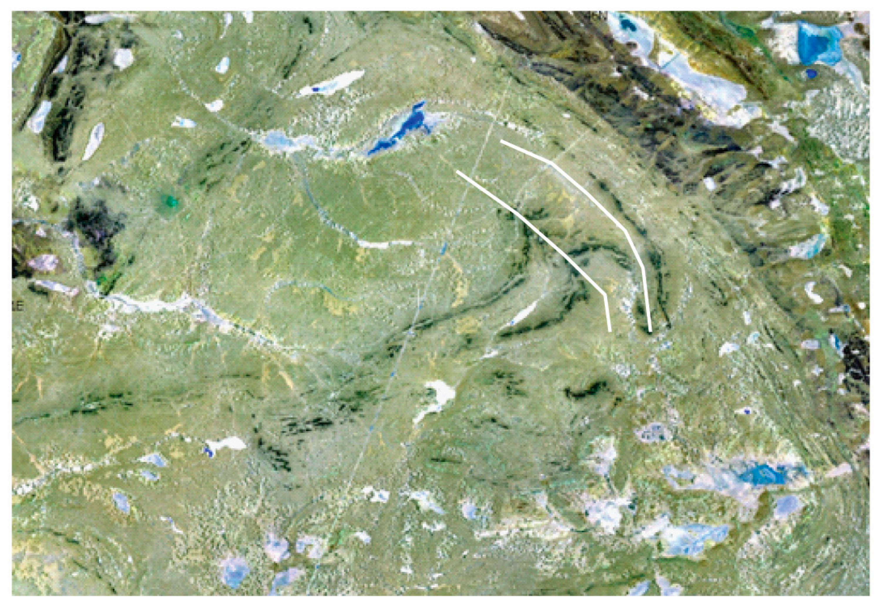
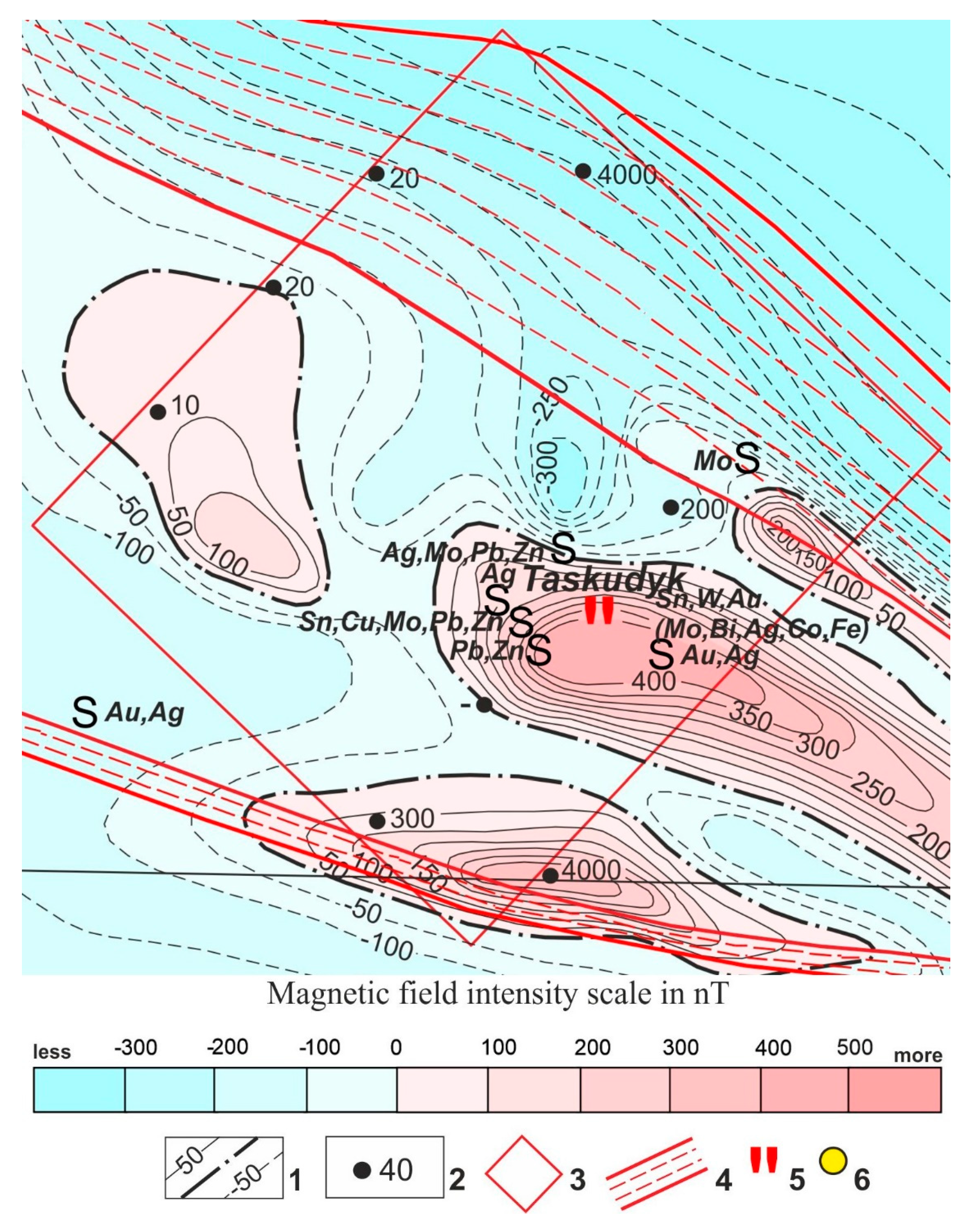
Late Cambrian basalt complex (C3). According to petrochemical data, part of the basalts occurring in the form of fragments of tectonic nappes and olistostromes in the Jalaiyr-Naiman and Sarytuma zone tectonic nappes, previously considered ophiolitic, in the Sunkar Mountains, along the stream, is assigned to this complex. Jideli and Karashygaly, at Sarytuma, in the Taskudyk field (
Figure 9 and
Figure 10), etc. According to the petrographic composition, these are aphyric and fine porphyry rocks, in places amygdaloid. It notes pillow basaltic lava. The texture of basalts is massive, almond-like; the structure is porphyritic, the groundmass is variolitic, vitrophyric. Plagioclase phenocrysts up to 2 mm in size are broken by cracks filled with chlorite. Plagioclase is replaced by sericite. The tonsils, up to 0.5 mm in size, are filled with either chlorite, carbonate, or quartz-chalcedony. The groundmass is either variolitic or chloritized glass; accessory leucoxenized sphene is observed. The rocks are not metamorphosed, subject only to greenstone changes and are slightly deformed.
Middle-Late Ordovician terrigenous-andesitic complex (O2-3). The complex can be traced over a long distance from the Kastek ridge to the area of the Range hillock in North-Eastern Betpakdala. In the Kastek Range, the complex is represented by the Kutyrgan Formation of amygdaloid basalts with interlayers of tuff sandstones and lenses of limestones containing trilobites and Dapingian-Sandbian brachiopods. This formation also includes volcanic rocks observed in drill cores beneath Mesozoic-Cenozoic sedimentary cover in the Khantau region. In Eastern Betpakdala they correspond to the Klyshkyrin Formation, consisting of sandstones, conglomerates - at the bottom, basaltic andesites, tuffs, tuff sandstones - in the middle part and sandstones, siltstones, limestones, acid tuffs - in the upper part. The formation is assigned to the Dapingian-Sandbian by its position in the section between conformably lying Flo-Dapingian and Sandbian deposits characterized by fauna. In northeastern Betpakdala, this complex includes the Savid, Algabass and Koyandy formations, composed of basaltic andesites, andesites, tuffs, tuff conglomerates (lower), conglomerates, sandstones, siliceous siltstones, and limestones (middle) and conglomerates, andesites, basaltic andesites, sandstones, limestone kami (top). Its age is determined as Sandbian by its position in the section above the faunally characterized Dapingian fields and the Sandbian fauna in the upper formations [
30,
32].
Mineralogical and petrographic studies: Section No. 1/1 – serpentinized pyroxenite. The texture is microcracked, the structure is fine-to-medium-grained. The rock in the sample is dark gray and fine-to-medium grained. The texture of the rock is flattened.
In thin section the rock is lighter and consists mainly of monoclinic pyroxene. The shape of the grains is irregular; in one nickel, parallel cleavage cracks are visible. The grains at one nick are colorless, the ends of the grains are torn and uneven, and the birefringence is low (
Figure 11). Some grains are replaced by serpentine and possibly chlorite, as can be inferred from the occasional blue interference. Pyroxene grains aggregates of serpentine have been registered in the interstices and they completely replaced pyroxenes. Microcracks with iron hydroxides fill were observed as well.
Section No. 1/2 – epidote-amphibole rock. The texture is slate, the structure is granofibronematoblastic. The rock in the sample is schistose, light greenish-gray micro-grained, hard rock.
The rock in the thin section is metasomatically altered, apparently the original rock is pyroxenite.
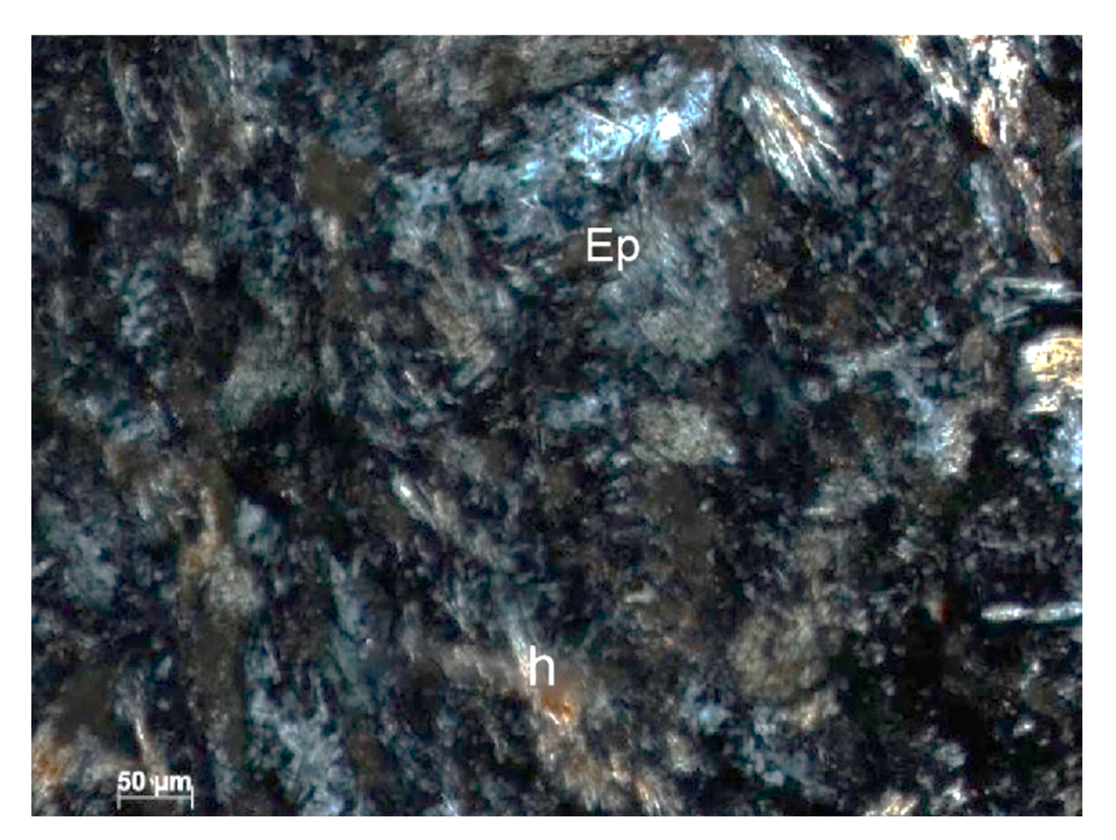
The thin section shows entirely replaced relief grains of elongated and oval shape, replaced by microgranular epidote, microprismatic amphibole (hornblende) (
Figure 12). In their spaces, needle-shaped amphibole is sometimes also developed. Judging by the replacement and the replaced grain outlines, it can be concluded that it was pyroxene. The rock contains single grains, apparently of vein quartz. The amphibole content in the rock is higher.
The amphibole orientation in some areas is parallel to elongation, which defines the schistose texture of the rock.
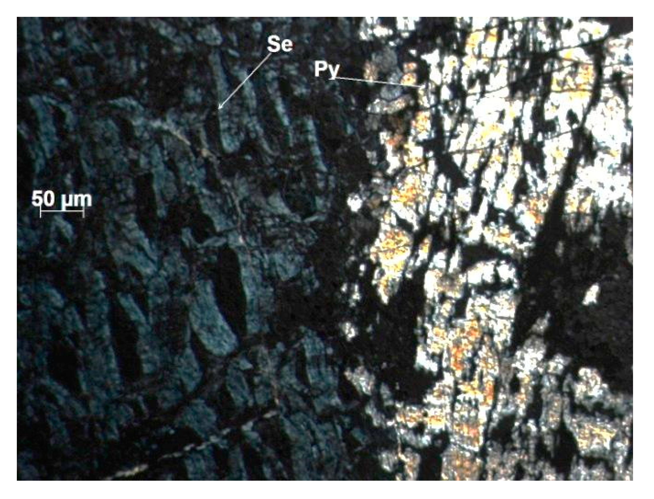
Section No. 1/3 - serpentinite. The texture is massive, the structure is lepidonematoblastic. The sample shows light zone development of serpentinized areas with dark gray areas; the hardness of the zones is low.
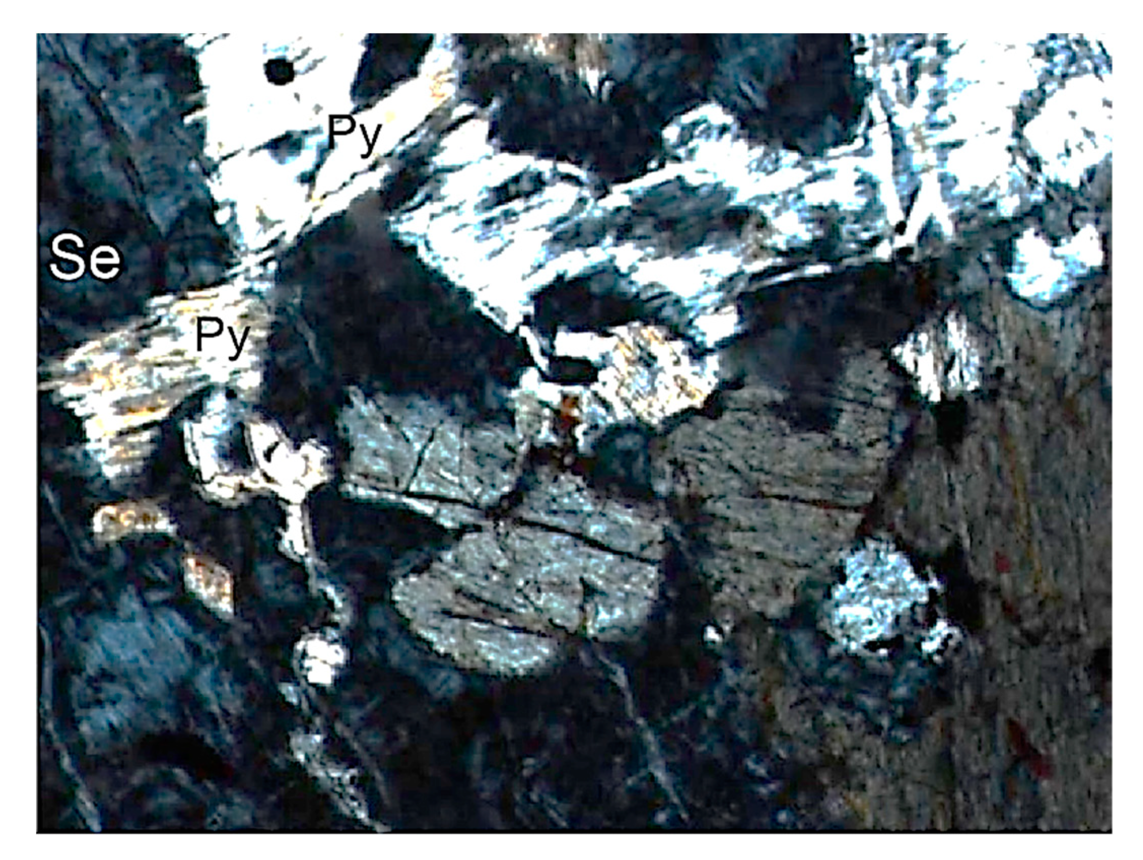
In a thin section of serpentine lattice structure, leucoxenized sphene development (up to 3%) of irregular bizarre shape was registered among them; sometimes, at the contact with iron hydroxides, which replaced magnetite, large pyroxene grain rare skeletal relics have also been registered (
Figure 13).
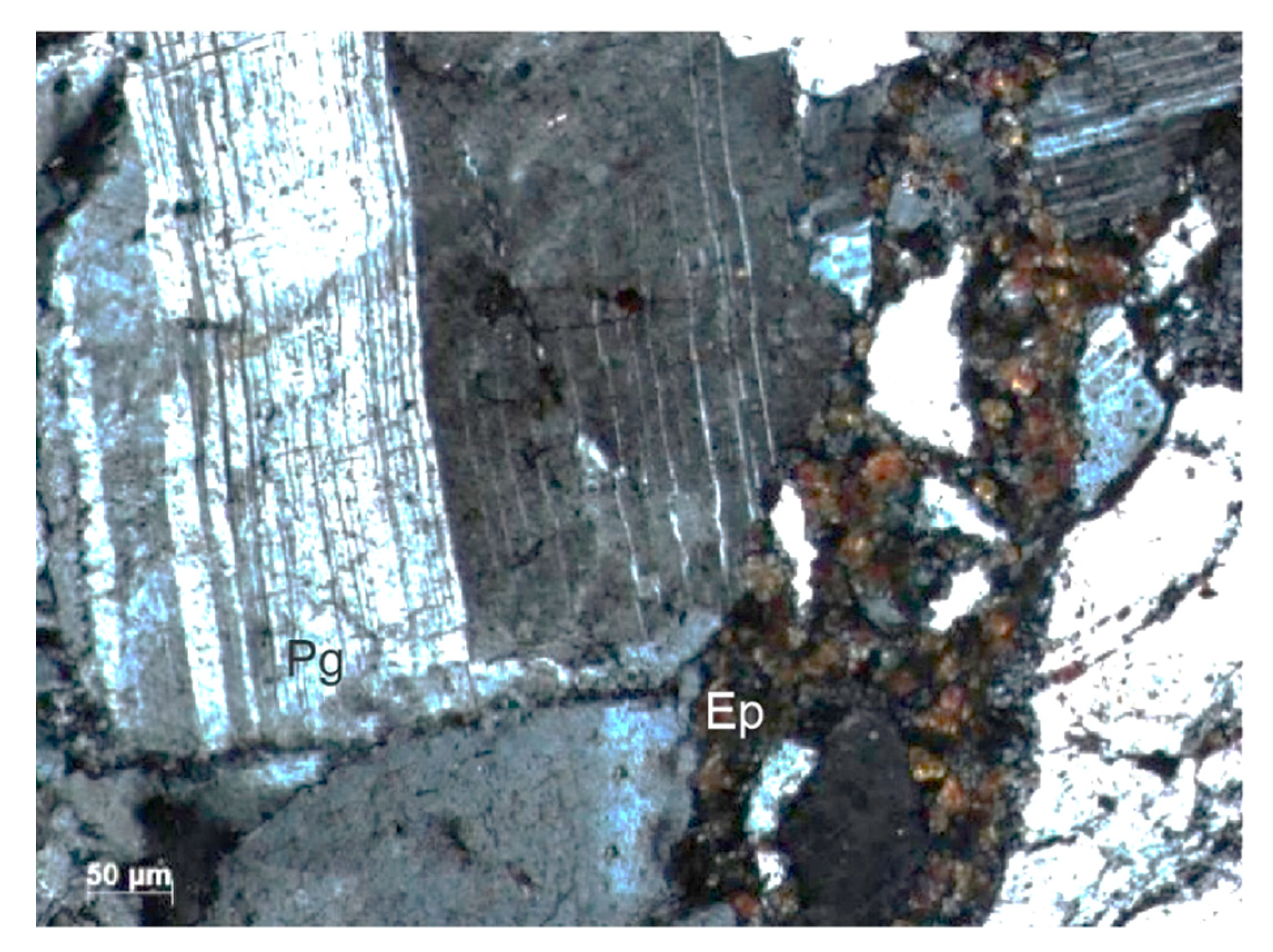
Thin section No. 1/4 – intensively brecciated, proquartized and epidotized anorthosite. The texture is fissured, veined, breccia structure. The rock in the sample is gray, yellowish-greenish, micro-grained, with quartz veinlets and aggregates of medium- and fine-grained quartz.
In the thin section, quartz deformed grains are angular, the main plagioclase prisms are angular and with curved polysynthetic twins, and quartz veinlets are registered. Larger fragments of these grains were cemented by small quartz vein formations. Subsequently, this entire mass was brecciated and cemented along cracks with microgranular epidote with a slight admixture of chlorite (
Figure 14).
The petrochemical characteristics of volcanics are typical for volcanic arc calc-alkaline series and continental-margin volcano-plutonic belts. The interpretation of the tectonic setting as a continental volcano-plutonic belt corresponds to a large volume of plutonic magmatism, complementary to volcanism [
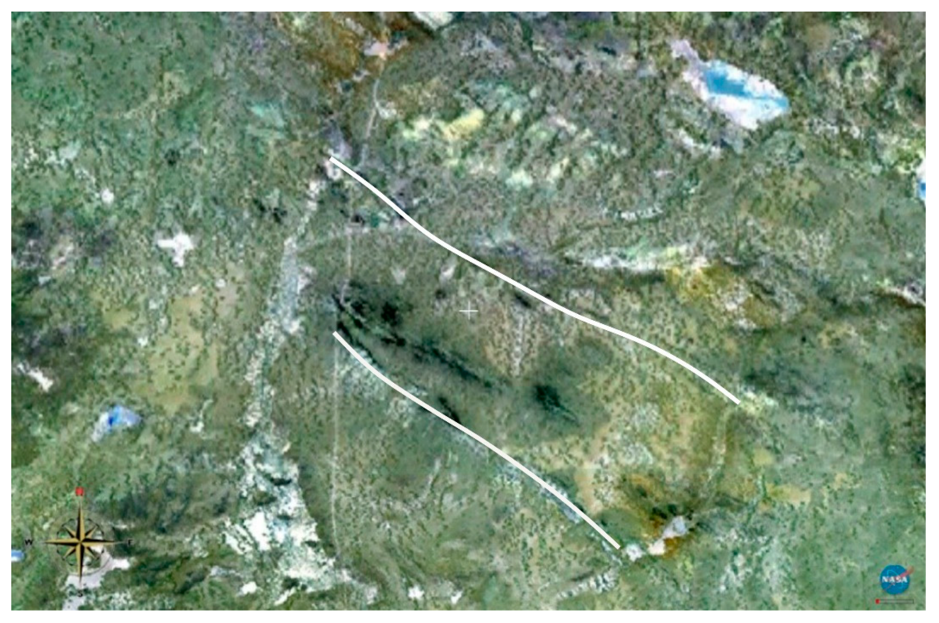
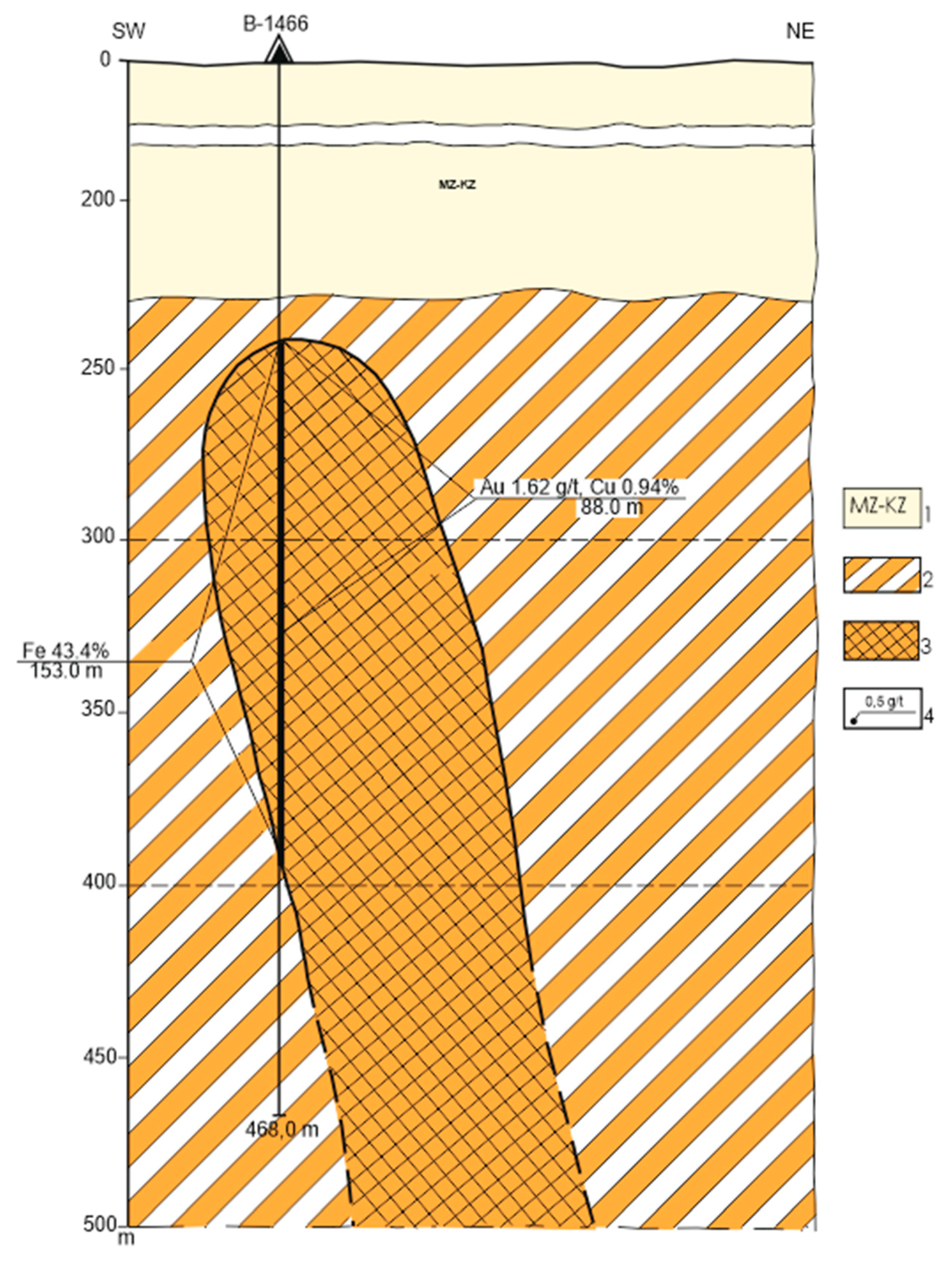
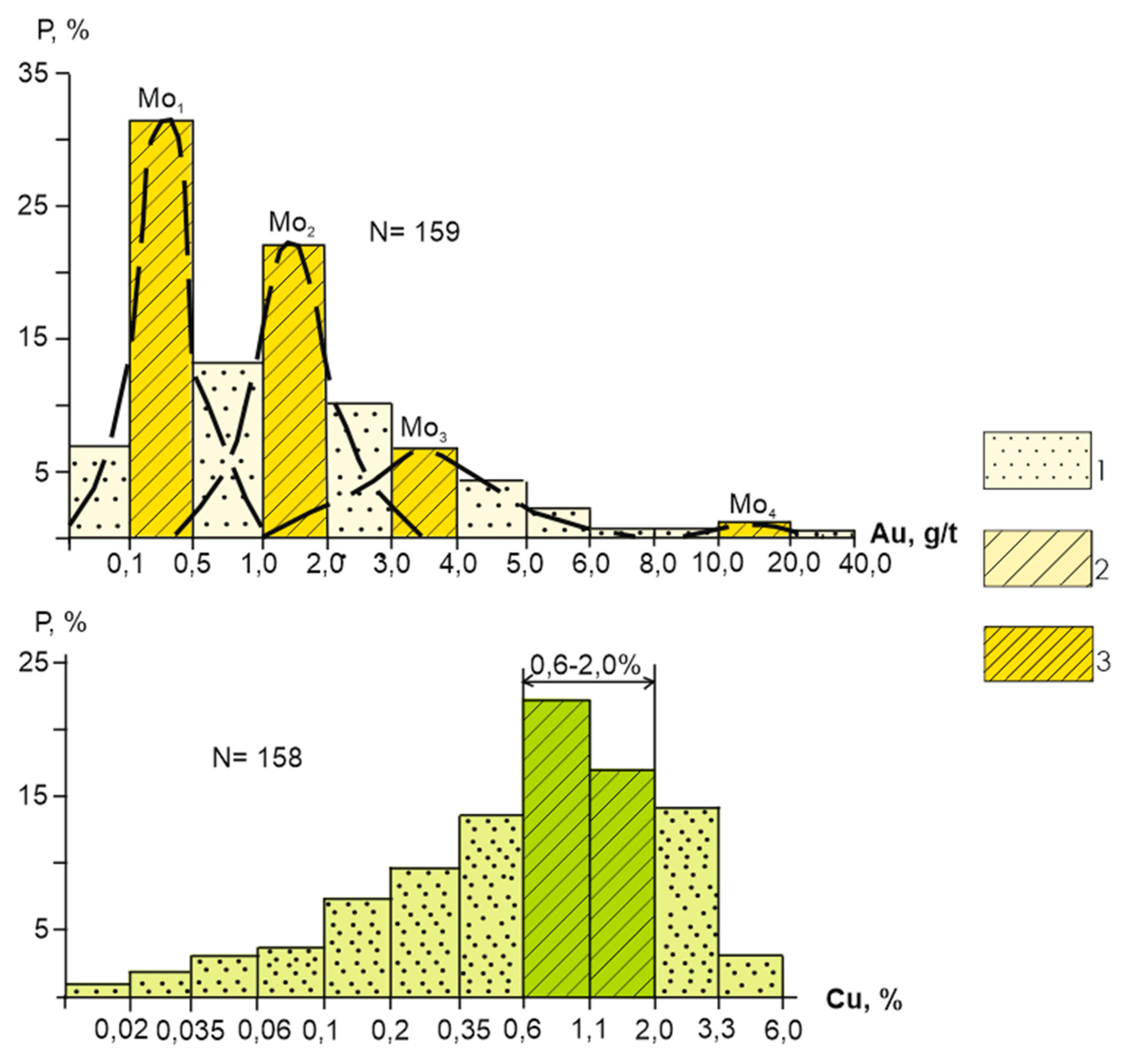
18]. The volcanic sequence lies conformably on the Early-Middle Ordovician complex of the basin. However, its deformation structure is very different from the underlying one. It is mainly epizonal of the fold-fault type middle tectonofacies, i.e., it is represented by an average degree fold of compression, disturbed by numerous brittle faults. In the the Khantau field area (
Figure 15,
Figure 16 and
Figure 17), being in a shear zone, it is subject to dynamometamorphism. Structural disharmony with the underlying complex is largely associated with the underwater landslide deformation participation in the flysch structure formation, as well as with different mechanical properties of thin-layered flysch and harder volcanic rocks. There may also be a disagreement associated with tectonic movements that caused a change in the slope of the zone and the volcanic arc transformation in the continental volcano-plutonic belt [
16].
Late Ordovician diorite-granodiorite complex (O3). In Eastern Betpakdala and Kendyktas, this complex is represented by the first two phases of intrusions of the Kordai-Shatyrkul and Ogiztau complexes, in the Zaile Alatau and Kastek ridge - by the Zaile complex similar phases, composed of gabbro, diorites, quartz diorites, granodiorites, syenodiorites. An important textural feature is the porphyritic nature of the main phase granodiorites and directive structures expressed by the K-feldspar porphyroblast and hornblend uniform orientation. Processing and analysis of petrochemical data on precursors compiled in [
44] provides grounds for the following conclusions. According to the ASI index (aluminum saturation index), the vast majority of granodiorites belong to the I-type. The Meniard-Piccoli diagram FeO/(FeO+MgO)-SiO
2 taking into account the ASI coefficient (aluminum saturation index) shows that almost all diorites, quartz diorites, granodiorites, syenodiorites were formed in the setting of island arcs or continental active margins. The age of the hornblende from the Kordai-Shatyrkul complex [
43] is 453+12 Ma. According to these data, the plutonic complex of the active continent was formed simultaneously with the volcanic one in Sandbian time. Their distribution areas coincide, and they form a single volcano-plutonic association. The formation of oriented structures was obviously associated with the deformation of massifs in a tense thermodynamic environment in the suture zone.
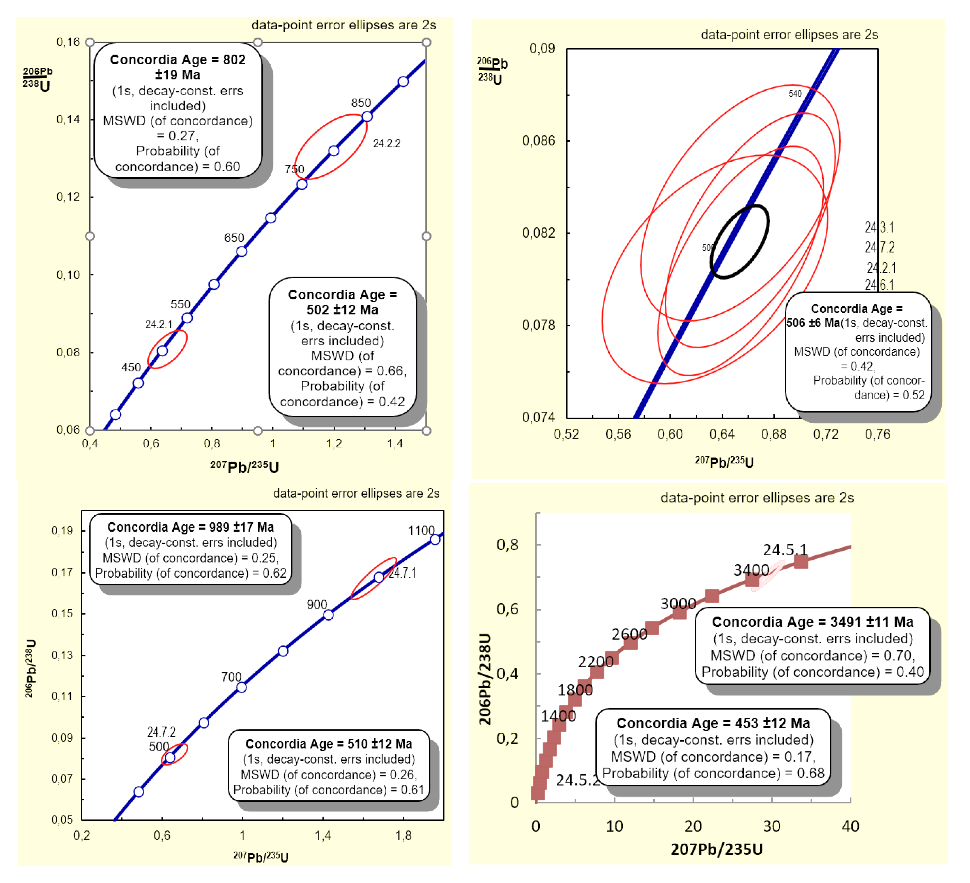
Diorites corresponding in age and petrochemical characteristics to the plutonic complex of the active zone were identified in the Anyrakhai Mountains. They form a narrow, layered body with a thickness of several hundred meters to 1-1.5 km, a length of a few tens of kilometers, occupying a position between the eclogite-bearing schist complex on ophiolites exhumed by the Middle-Late Ordovician cover. Petrochemically, the rocks are classified as diorites. On previously compiled maps, the intrusion is Proterozoic. A sample was taken from the diorites for U/Pb zircon geochronology The Central Laboratory performed a SHRIMP analysis of zircon grains from this sample. The results are striking (
Table 1) (
Figure 18 and
Figure 19). Uranium-lead and Pb/Pb ages ages were determined for seven zircon grains. Grain cores yield concordant ages of, Ma: 3491±11, 999±23, 989±17, 802±19. For the outer zonal shells of grains, yield slightly discordant ages of: 502±12, 506±6 and 510±12. For the outermost transparent shell of one grain, a concordant age of 453 ± 12 was obtained. These age results show that five important tectonic events are recorded by the zircons in the diorites. It can be assumed that zircon with Precambrian ages were extracted from a section of the crust during the exhumation of an eclogite-bearing complex. If this is so, then there are traces of the formation of the Paleoproterozoic protocrust (a phenomenon exclusive to Central Eurasia), the formation and breakup of Rodinia. The Middle Cambrian ages of 502-510 Ma coincide with the age of the Jalaiyr-Naiman sea, obtained from our sample in the same laboratory. The Late Ordovician suture complex of Eastern Betpakdala and Kendyktas is 453 Ma. Thus, all ages can be explained by known tectonic events and confirm their importance for understanding the geodynamics of the region. The age of 453 Ma [
42] is also found in some granitoids within the Sarytuma zone, which were previously conventionally attributed to the Kontak complex. This should also include the intrusions of the Zhalgyzkudyk complex in the southwestern Balkhash region, which are similar in composition to the Kordai complex. The position of these intrusions, like the Anyrakhai one, in geodynamic terms corresponds to the frontal zone of the magmatic arc. Probably, magmas penetrated here originated from the main magmatic zone of the belt along the sutures of the steeply dipping suture between West Balkhash Synclinorium and Jalaiyr-Naiman Synclinorium, recorded on seismic sections.
Early-Middle Devonian intrusive complexes of the continental volcano-plutonic belt (D1-2). Intrusive complexes were formed according to the volcanic sequence each sequence corresponded to its own intrusive complex. The Lower Devonian sequence in North-Eastern Betpakdala was accompanied by the Karamendy intrusive complex, consisting of three phases. The first phase is quartz diorites and diorites, the second phase is granodiorites, the third phase is plagiogranites. The age of the complex, determined by the potassium-argon method, is 404 Ma (average of 17 determinations in the range of 394-408 Ma). The ASI index (aluminum saturation index) for granites is 0.89, which defines them as I-type granites. The shape of the intrusions is affected by large faults. In the Shu-Balkhash watershed, the Kyzyljartas complex is similar in composition and age to the Karamendy complex. It is composed of small stock-like massifs and dike-like bodies. The rock composition is variable, amphibolized gabbroids and diorites representing the first phase are present, but granodiorites and quartz diorites of the second main phase predominate. According to petrochemical features, these are typical granitoids of continental margin volcano-plutonic belts (
Table 2) (
Figure 20 and
Figure 21). The intrusions occur mostly among Late Ordovician flyschoids but cut through the Lower-Middle Devonian Koktas Formation. The pebbles of the Kyzyljartas complex rocks are found in Famennian conglomerates. The method-Pb zircon age is 395 Ma. The age of the complex is considered to be Early Devonian. It is well-known for containing large deposits of gold [
11,
13,
23].
Late Devonian granite-leucogranite complex (D3). In the south, in the Kendyktas mountains,the Jadrin complex is composed of leucocratic biotite and leucogranite granites, that intrude Late Ordovician sedimentary rocks and granites.
207Pb
206Pb zircon ages from this complex are 374 Ma. In the Shu-Ile watershed, suture granites are represented by the Jeltau complex, which is composed of several massifs, the largest of which is the northwest-striking Jeltau complex. According to geophysical data, this is a flat, relatively thin (2-3 km) body, lying subhorizontally and occupying an interformational position between Ordovician and Devonian strata. The first phase includes granodiorites, diorites and syenodiorites, the second main phase includes leucocratic and biotite granites, granosyenites, the third phase includes aplite-like and leucogranite (
Table 3,
Table 4,
Table 5 and
Table 6) (
Figure 22,
Figure 23,
Figure 24 and
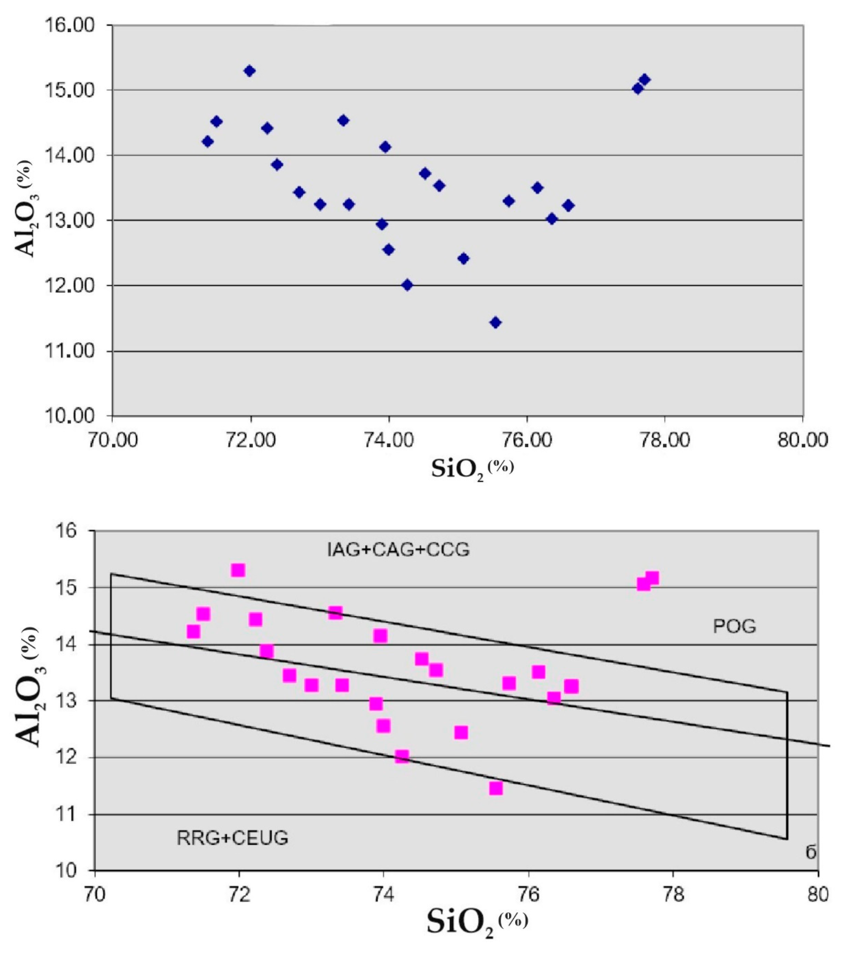
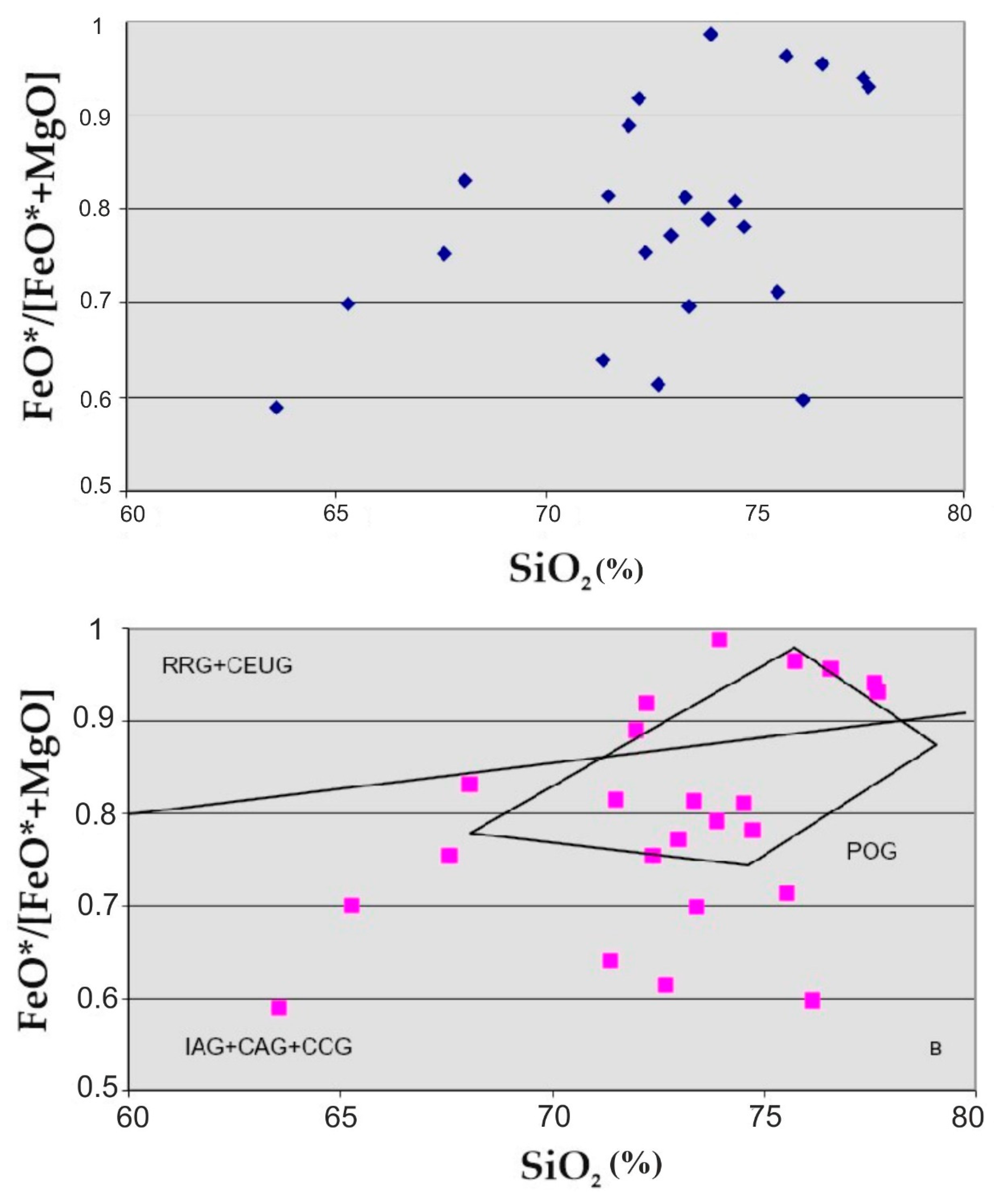
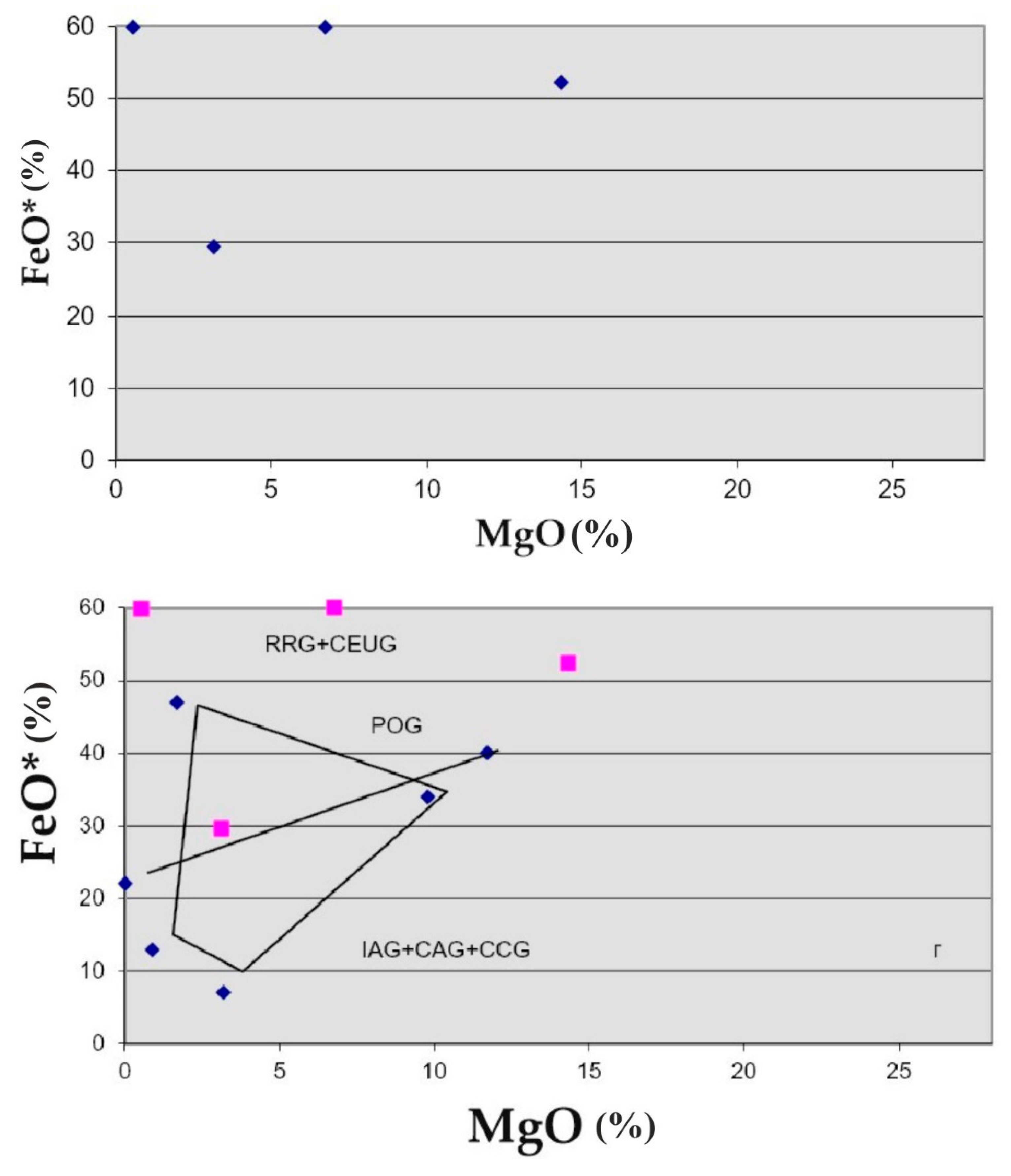
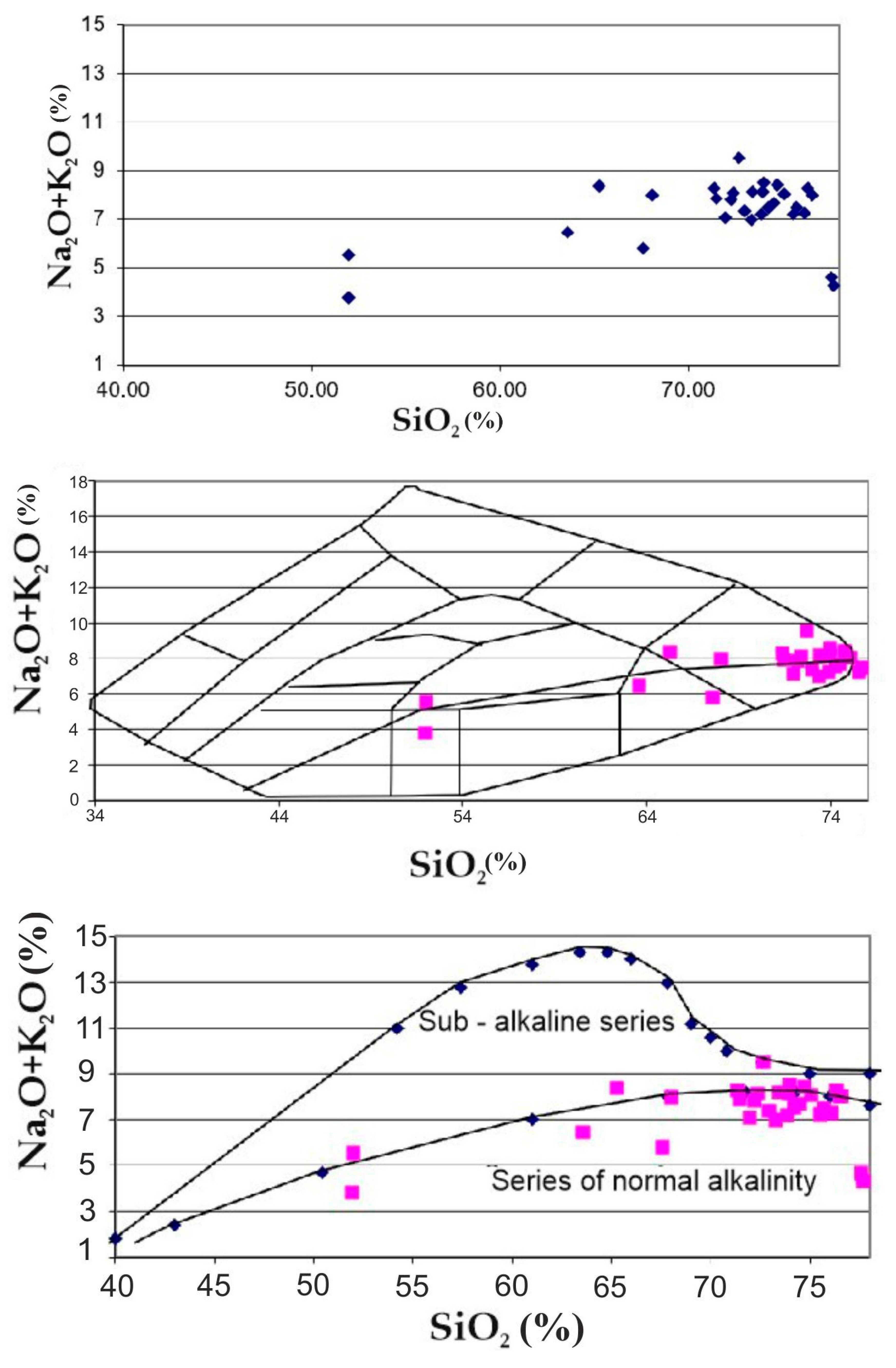
Figure 25). According to the petrochemical features, the granites of the Jeltau complex are overwhelmingly late orogenic. The exception is several samples of anorogenic granites, apparently not related to this complex.
The petrochemistry of the Jadrin complex is different. It contains varieties corresponding to both late orogenic granites (minority), and postorogenic, as well as anorogenic. The explanation for this difference between the Jeltau and Jadrin complexes may be in the difference in their position in relation to the Jongar-Balkhash orogenic region. The Jeltau complex is located on the outskirts of the Jongar-Balkhash orogenic region and defines its borders. The intrusions of this complex cut Middle-Upper Devonian volcanic strata. Clasts of the volcanic rocks exist in the Famennian conglomerates, indicating a 382 Ma age of the intrusions. The Jadrin complex is located outside the Jongar-Balkhash orogenic region. It issignificantly separated in time of formation from the Lower Paleozoic host rocks and is post-orogenic or possibly anorogenic in terms of the known orogenic events of this region. Ar-Ar thermochronology on micas and hornblende yield an age of 360-370 Ma. However, the rubidium-strontium isochron ages yield older ages for the Jeltau massif of 398 ± 20 Ma [
2]. Similar data were obtained for other leucogranite massifs in southern Kazakhstan. These data are consistent with U-Pb zircon ages (385±12 Ma for the Aidarly massif, etc.) [
40,
42,
45]. Such contradictions can only be explained by a complex, heterogeneous mechanism of formation of massifs, for example, early crystallization of colored minerals and the emplacement of such partially crystallized magma into shallower crustal depths, in this case into the volcanic strata of the Middle-Upper Devonian. In the northern part of the region, suture leucogranites are represented by the Shunak complex. It makes up the Kaiyp group of massifs that cut across Ordovician strata. Clasts of these granites are contained in Famennian conglomerates. Their first phase is composed of medium-to-coarse-grained, the second phase of fine- and medium-grained leucogranites and alkaline leucogranites. Petrochemistry confirms the collision nature of granites. Radiological data, as for the southern regions, give Late Devonian and older figures. The intrusions of the complex are characterized by tin-tungsten-molybdenum mineralogy.
New data on Pb, Cu and Sb sulfosalts were discovered during a microscopic study of ores from the Karier and Dumanshuak gold deposits in the Akbakai region. At the Karier deposit, semseyite Pb
9Sb
8S
21 (Pb 52.82 %, Sb 28.64 %, S 18.54 %) was recorded for the first time for the Akbakai type gold deposit. Chemical composition of bournonite at the Karier deposit, %: Pb 40.18; Sb 27.13; Cu 13.34; S 19.35. Jamsonite of the Dumanshuak deposit has the composition, %: Pb 38.04; Fe 2.86; Sb 38.04; S 21.35 [
3,
4].
Let us note rare metal and uranium-containing minerals recorded in gold-bearing ores of some deposits of the Main Suture Zone. At the Kengir deposit, monazite (Ce,La,Nd)PO4 of the following composition,%: Ce 27.81; La 14.28; Nd 1.89; Cd 1.28; P 14.05. At the Shatyrkul deposit, in beresitized, silicified and hematized gold-bearing diorite, zircon, - thorium, - molybdenum-bearing uraninite, %: U 66, 10-69, 80; Zr 3, 36-3.81; Th up to 1.4; Mo up to 1.77.
In the process of field work, a revision of the reference main suture zone ore objects was carried out with a complex of analytical and mineralogical-geochemical studies [
15]. Ores, hydrothermally altered formations and host rocks of gold deposits Ashiktas, Maikabat, Altynsai, Svetinsk, Jaksy, Kopbai, Vostochnyi, Tokensk, Shokpar Severnyi, Kyrgau Severny, Mynaral, Sarytas, etc. were analyzed using various methods; rare metals - Shalkiya, Karaoba, Biye, Sarybulak; copper and lead-zinc - Shatyrkul, Talkudyk, Saryshagan, Buryltas, etc.
The results of the analyses correlate well with the field observation materials. High and medium gold contents were identified in sulfide-quartz veins and stockworks of the Ashiktas, Altynsai, Maykabat, Vostochny and Katpar deposits. The complex lithophilic specialization of rare metal objects (W, Mo, Sn, Bi, sometimes Be, Li) has been confirmed. The presence of gold in deposits of non-ferrous metals (Buryltas, Talkudyk) has been established. The Ashiktas epithermal gold deposit is accompanied by elevated contents of Ba (more than 1 %), Cu and Sb (0.1 %). Elevated and high silver contents (10-100 g/t or more) are observed in ores of gold deposits (Ashiktas, Vostochnyi, Sarytas), rare metals (Shalkiya, Biye), and non-ferrous metals (Shatyrkul, Talkudyk). The deposits considered are characterized by a complex composition and a wide geochemical spectrum, which is important to take into account when predicting and searching for new ore objects in the studied territory, and conducting prospecting geological assessment work [
20,
21,
22,
23,
24,
41].
Original mineralogical data were obtained by studying polished sections using a Superprope-733 electron probe microanalyzer (Japan). The most common mineral forms of Au and Ag are silver gold and electrum. Silvery gold is present in the ores of the deposits, %: Gagarinsk (Au 73.77-77.82; Ag 22.18-26.52), Mynaral (Au 74.37-76.78; Ag 21.43-23.67; Cd 1.5-1.6), Northern Kyrgau (Au 79.90-80.23; Ag 17.50-18.90), Khantau (Au 85.42-89.59; Ag 10.41-14, 58), Shatyrkul (Au 78.11; Ag 20.66; Cd 1.23). Electrum was found in the ore bodies of the deposits, %: Shokpar Severny (Au 59.87-60.43; Ag 39.57-40.13), Ushalyk (Au 55.00; Ag 40.57), Kogadyr (Au 58.43; Ag 41.57), Mynaral (Au 63.56; Ag 34.11), Gagarinsk (Au 68.97; Ag 31.03) [
28,
35].
It should be noted the importance of bismuth minerals in some gold ore and gold-bearing deposits of the studied zone. Aikinite PbCuBiS3 is an indicator of the Kyrgau North gold-sulfide deposit in the Kastek region. Native bismuth Bi, tetradymite Bi2Te2S, hadleyite Bi2Te2 are minerals common to the Kengir gold deposit in the Akbakai region and the Buryltas gold-base metal deposit in the Sarytuma zone. In the gold-bearing skarnoids of the Buryltas deposit, for the first time, using a microanalyzer, minerals were detected whose composition corresponds to lillianite Pb3Bi2S6 and beegerite Pb6Bi2S9.
Figure 1.
Location map of the Shu-Ile belt.
Figure 1.
Location map of the Shu-Ile belt.
Figure 2.
Location of the JBFS (Jungar-Balkhash Fold System) in the Central Asian Orogenic Belt. Fold systems: 1-Hercynian (1—Uralian, 2—Jungar-Balkhash, 3—Zaysan); 2- platform mantle; 3- lakes; 4- Caledonian (4—Kokshetau-North Tian Shan, 5—Shynghys-Tarbogatay, 6—Altai-Sayan); 5- neotectonic basins; 6- country border.
Figure 3.
Shu-Ile region tectonic zoning scheme (geological structures of the first order) according to [
29].
Figure 3.
Shu-Ile region tectonic zoning scheme (geological structures of the first order) according to [
29].
Figure 4.
Tectonic stratigraphic chart of Shu-Ile belt.
Figure 4.
Tectonic stratigraphic chart of Shu-Ile belt.
Figure 5.
symbols for tectonic stratigraphic chart of Shu-Ile belt.
Figure 5.
symbols for tectonic stratigraphic chart of Shu-Ile belt.
Figure 6.
Zoning of the Shu-Ile region.
Figure 6.
Zoning of the Shu-Ile region.
Figure 7.
Isoclinal recumbent fold in the complex of the Neoproterozoic of the Shu block. White lines show the trace of fold axes.
Figure 7.
Isoclinal recumbent fold in the complex of the Neoproterozoic of the Shu block. White lines show the trace of fold axes.
Figure 8.
Isoclinal fold in ferruginous quartzites at the Gvardeisk field.
Figure 8.
Isoclinal fold in ferruginous quartzites at the Gvardeisk field.
Figure 9.
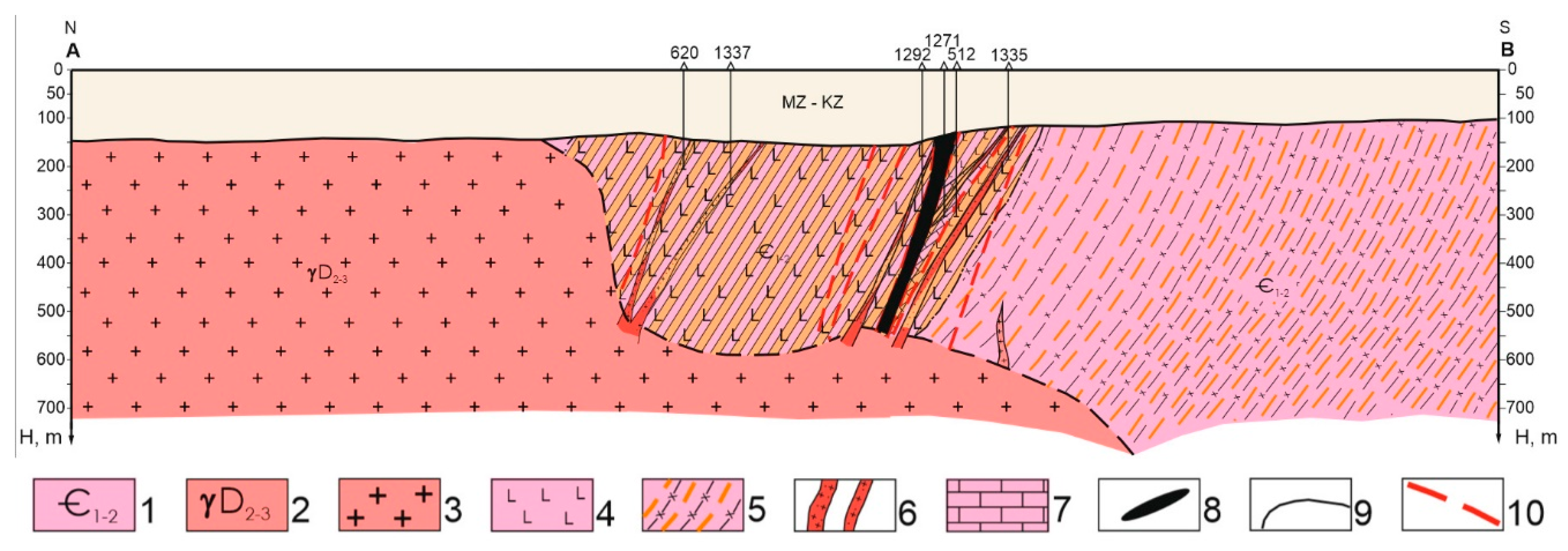
Geological section of the Taskudyk field: 1 - Lower Cambrian, Aschysu formation, basalt and diabase porphyrites and their tuffs. Greenstone shales based on volcanic rocks and tuffs of basic composition; 2 - Zheltau complex. biotite and leucocratic granites; 3 - granites; 4 - basalt and diabase porphyrites; 5 - epidote-albite-chlorite, leu-coxene-chlorite-actinolite shales; 6 - dikes of quartz porphyry and granite porphyry; 7 - marbled limestones; 8 - iron ore bodies; 9 - geological boundaries; 10 - discontinuous faults.
Figure 10.
Map of the anomalous magnetic Taskudyk mine field: 1 - magnetic field isolines and their values, nT: a) positive, b) zero, c) negative; 2 - wells indicating the average value of magnetic susceptibility of pre-Mesozoic basement rocks in n∙10-6 per well; 3 - outline of the site of detailed ground magnetic survey at a scale of 1:10000 (Shevchuk, 1982); 4 - zones of collapse and shearing; 5 - Taskudyk field; 6 - points of mineralization.
Figure 11.
Section No. 1/1: irregular grains of monoclinic pyroxene with low interference colors, magnification 200x, crossed nicols.
Figure 11.
Section No. 1/1: irregular grains of monoclinic pyroxene with low interference colors, magnification 200x, crossed nicols.
Figure 12.
Section No. 1/2: irregular and needle-like grains of hornblende (h) and microgranular aggregates of epidote (Ep), crossed nicols, magnification 200x.
Figure 12.
Section No. 1/2: irregular and needle-like grains of hornblende (h) and microgranular aggregates of epidote (Ep), crossed nicols, magnification 200x.
Figure 13.
Section No. 1/3: lattice serpentine (Se) in contact with relict grains of pyroxene (Py), crossed nicols, magnification 200x.
Figure 13.
Section No. 1/3: lattice serpentine (Se) in contact with relict grains of pyroxene (Py), crossed nicols, magnification 200x.
Figure 14.
Section No. 1/4: deformed grains of basic plagioclase (Pg), cemented by vein quartz and epidote (Ep), crossed nicols, magnification 200x.
Figure 14.
Section No. 1/4: deformed grains of basic plagioclase (Pg), cemented by vein quartz and epidote (Ep), crossed nicols, magnification 200x.
Figure 15.
Geological map of the pre-Mesozoic basement of the Khantau ore district with gold halos: 1 - loose Mesozoic-Cenozoic deposits; 2 - Upper Devonian, Famennian stage-Lower Carboniferous, Tournaisian stage (sandstones, conglomerates, siltstones); 3 - andesites, andesitic tuffs, tuffites, tuff sandstones, diabase porphyrites; 4 - shales (in the shear zone) quartz-sericite, quartz-biotite-feldspar, amphibole plagioclase, chlorite, quartz-biotite-amphibole, quartz-amphibole (on the map). Late Ordovician intrusions (Kordai-Shatyrkul complex): 5 - granites; 6 - plagiogranites; 7 - granodiorites; 8 - diorites, quartz diorites. Early Paleozoic intrusions (Shu-Balkhash complex): 9 - pyroxenites, peridotites, serpentinites; 10 - keratinization, skarning (on the map); 11 - sheared and skarned rocks; 12 - gold-bearing garnet-chalcopyrite-magnetite skarns; 13 - geological boundaries: 1) consonant and intrusive, 2) unconformable; 14 - faults: 1) main, 2) secondary; 15 - crumple zones; 16 - the same under sediments of the inland basin; 17 - tectonic melange; 18 - magnetic field isolines: 1) positive, 2) zero, 3) negative; 19 - potential medium (1) and small (2) deposits of the Khantau gold-copper-iron skarn type; 20 - Barhan nickel-cobalt ore occurrence in silicate weathering crusts; 21 - ore bodies identified by magnetic prospecting data and confirmed by drilling; 22 - ore body, inferred from magnetic exploration data at depth; endogenous gold halos (according to well testing data), g/t: 23 - 0.01-0.05; 24 - 0.05-0.5; 25 - 0.5-1.5; 26 - maximum gold content; 27 - wells drilled by the Khantau party: in the numerator - the well number, in the denominator - the depth to the surface of the pre-Mesozoic basement (magnetic susceptibility in n∙10-6 - on the DZ magnetic field map); 28 - ore-bearing intervals: in the numerator - average contents of Au, Cu and Fe, in the denominator - shaft thickness.
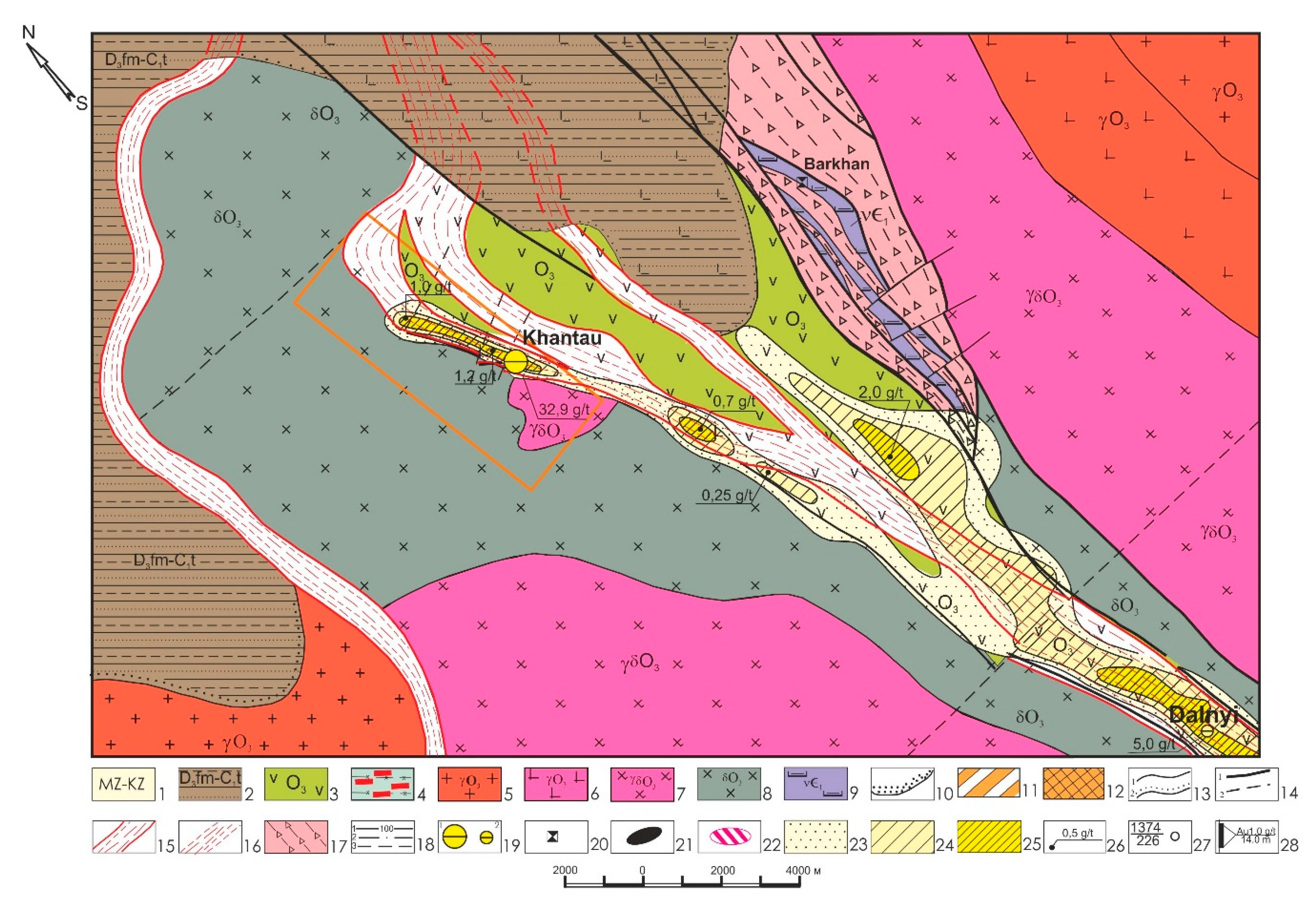
Figure 16.
Geological section through well S-1466: 1 - loose Mesozoic-Cenozoic sediments; 2 - sheared and skarned rocks; 3 - gold-bearing garnet-chalcopyrite-magnetite skarns; 4 - maximum gold content (g/t).
Figure 16.
Geological section through well S-1466: 1 - loose Mesozoic-Cenozoic sediments; 2 - sheared and skarned rocks; 3 - gold-bearing garnet-chalcopyrite-magnetite skarns; 4 - maximum gold content (g/t).
Figure 17.
Histograms of the distribution of Au, Cu and Fe in the ore zone of the Khantau deposit: endogenous gold halos (according to well sampling data), g/t: 1 - 0.01-0.05; 2 - 0.05-0.5; 3 - 0.5-1.5.
Figure 17.
Histograms of the distribution of Au, Cu and Fe in the ore zone of the Khantau deposit: endogenous gold halos (according to well sampling data), g/t: 1 - 0.01-0.05; 2 - 0.05-0.5; 3 - 0.5-1.5.
Figure 18.
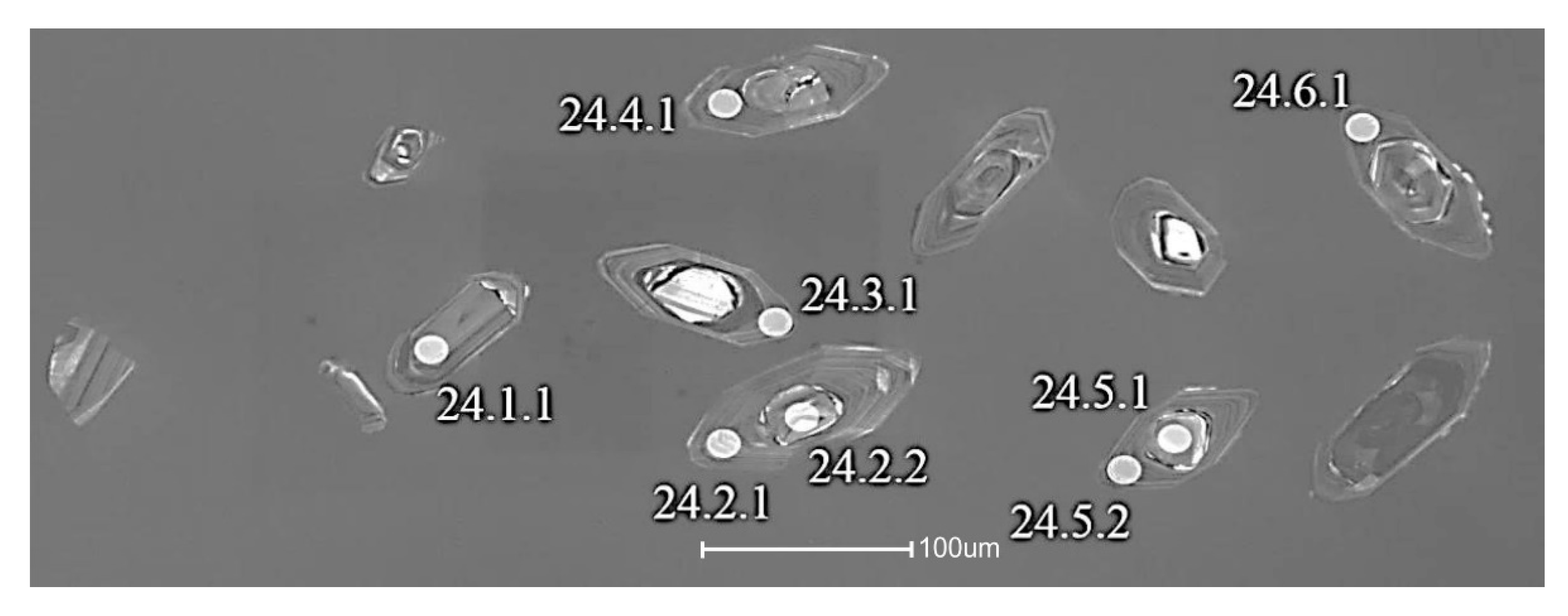
Zoned zircon grains and SHRIMP age determination sites [
2].
Figure 18.
Zoned zircon grains and SHRIMP age determination sites [
2].
Figure 19.
Concordia based on zircon grains from diorites cutting through the eclogite-bearing complex [
2].
Figure 19.
Concordia based on zircon grains from diorites cutting through the eclogite-bearing complex [
2].
Figure 20.
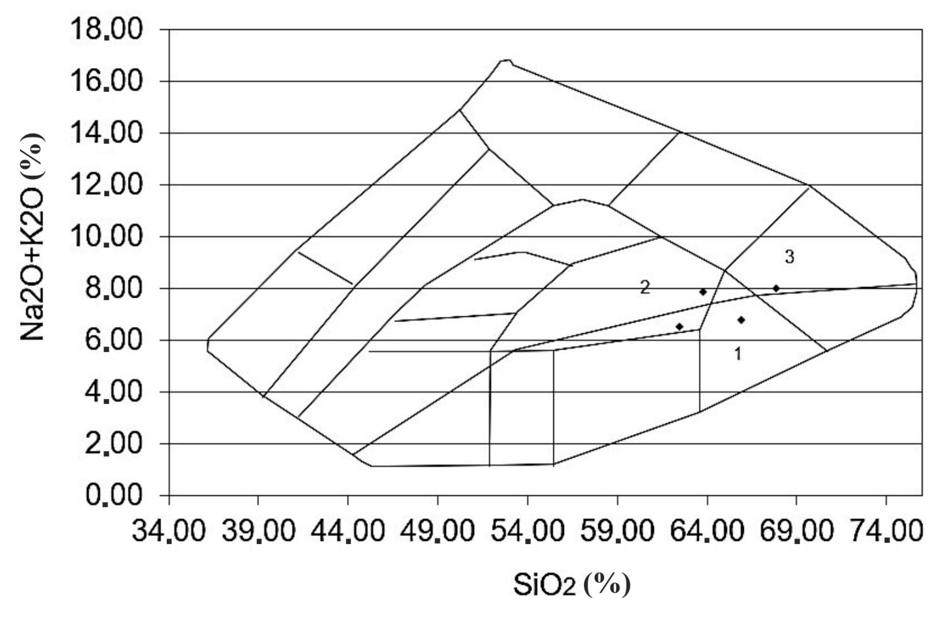
Kyzyljartas intrusive complex: 1 - quartz diorite, 2 - monzonite, 3 – alkaline granite [
2].
Figure 20.
Kyzyljartas intrusive complex: 1 - quartz diorite, 2 - monzonite, 3 – alkaline granite [
2].
Figure 21.
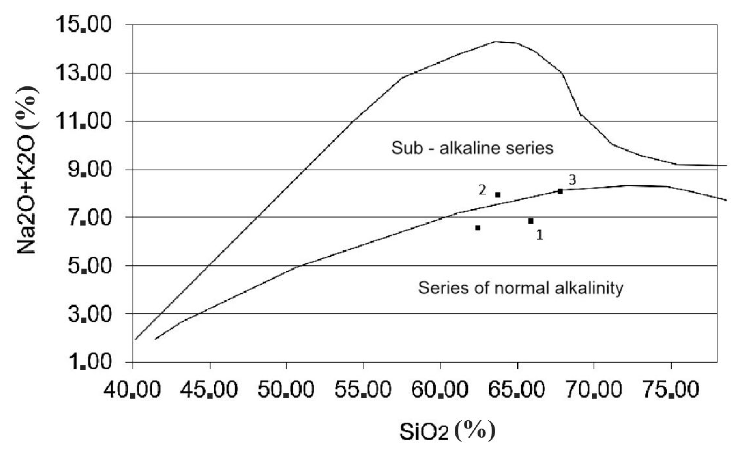
Kyzyljartas intrusive complex: 1 - quartz diorite, 2 - monzonite, 3 - alkaline granite [
2].
Figure 21.
Kyzyljartas intrusive complex: 1 - quartz diorite, 2 - monzonite, 3 - alkaline granite [
2].
Figure 22.
Jeltau intrusive complex Petrochemistry.
Figure 22.
Jeltau intrusive complex Petrochemistry.
Figure 23.
Jeltau intrusive complex petrochemistry.
Figure 23.
Jeltau intrusive complex petrochemistry.
Figure 24.
Jeltau intrusive complex petrochemistry.
Figure 24.
Jeltau intrusive complex petrochemistry.
Figure 25.
Jeltau intrusive complex petrochemistry.
Figure 25.
Jeltau intrusive complex petrochemistry.
Table 1.
Isotope ratios and zircon age [
2].
Table 1.
Isotope ratios and zircon age [
2].
| Spot |
%
206Pbc
|
ppm
U |
ppm
Th |
232Th
/238U |
ppm
206Pb* |
(1) 206Pb
/238U
Age |
(1) 207Pb
/206Pb
Age |
%
Discor-
dant |
Total
207U±%
/206Pb |
Total
207Pb±%
/206Pb |
(1)
238U/±%
206Pb* |
(1)
207Pb*±%
/206Pb* |
(1)
207Pb±%
/235U* |
(1)
206Pb*±%
/238U* |
err
corr |
24.5.2
24.4.1
24.6.1
24.2.1
24.7.2
24.3.1
24.2.2
24.7.1
24.1.1
24.5.1 |
4.60
2.67
0.99
0.19
0.37
0.51
0.35
0.00
0.61
0.11 |
604
627
554
507
457
527
220
608
208
166 |
739
647
649
555
575
563
179
373
62
119 |
1.26
1.07
1.21
1.13
1.30
1.10
0.84
0.63
0.31
0.74 |
39.7
42.2
38.7
35.3
32.3
37.9
25.3
87.2
30.2
101.0 |
453±12
474±12
499±12
501±12
509±12
516±12
805±19
996±23
1000±24
3435±68 |
546 ±220
450±170
499±110
557±67
545±69
489±90
769±67
978±26
939±74
3492±11 |
21
-5
0
11
7
-5
-4
-2
-6
2 |
13.08 2.6
12.75 2.5
12.3 2.5
12.35 2.5
12.13 2.5
11.94 2.5
7.49 2.6
5.99 2.5
5.92 2.6
1.418 2.5 |
0.096 2.8
0.0776 2
0.0652 2.5
0.0603 2.2
0.0614 2.4
0.061 2.6
0.0677 2.4
0.0716 1.3
0.0755 2.1
0.3053 0.67 |
13.71 2.7
13.1 2.6
12.43 2.5
12.38 2.5
12.17 2.5
12 2.5
7.52 2.6
5.99 2.5
5.95 2.6
1.42 2.5 |
0.0585 10
0.056 7.7
0.0572 5
0.0587 3.1
0.0584 3.2
0.0569 4.1
0.0648 3.2
0.07174 1.3
0.0704 3.6
0.3043 0.68 |
0.586 10
0.588 8.1
0.634 5.6
0.654 4
0.661 4
0.654 4.8
1.189 4.1
1.652 2.8
1.629 4.4
29.53 2.6 |
0.0728 2.7
0.0762 2.6
0.0804 2.5
0.0808 2.5
0.0821 2.5
0.0833 2.5
0.133 2.6
0.167 2.5
0.1679 2.6
0.704 2.5 |
.262
.314
.449
.632
.624
.524
.630
.888
.583
.966 |
Table 2.
Petrochemical characteristics of Kyzyljartas intrusive complex granodiorites [
2].
Table 2.
Petrochemical characteristics of Kyzyljartas intrusive complex granodiorites [
2].
| Name of species |
1 |
Granodiorite (%) |
Granodiorite (%) |
Granodiorite (%) |
Diorite-porphyrite (%) |
| №r/o |
2 |
1 |
2 |
3 |
4 |
| № species |
3 |
5043(9) |
5048(9) |
5049(9) |
5147(10) |
| SiO2
|
4 |
62.45 |
67.83 |
65.88 |
63.76 |
| Al2O3
|
5 |
15.44 |
14.96 |
15.62 |
14.38 |
| Fe2O3
|
6 |
1.51 |
1.46 |
1.37 |
5.67 |
| FeO |
7 |
2.83 |
2.01 |
2.91 |
|
| TiO2
|
8 |
0.53 |
0.48 |
0.7 |
0.35 |
| MnO |
9 |
0.07 |
0.06 |
0.07 |
0.05 |
| MgO |
10 |
2.52 |
1.71 |
1.92 |
1.63 |
| CaO |
11 |
3.35 |
1.44 |
2.3 |
3.5 |
| Na2O |
12 |
3.89 |
5.92 |
4.97 |
4.55 |
| K2O |
13 |
2.63 |
2.11 |
1.83 |
3.33 |
| P2O5
|
14 |
0.16 |
0.13 |
0.14 |
0.17 |
| P.i.r. |
15 |
4.47 |
1.55 |
1.88 |
2.62 |
| Sum |
16 |
99.99 |
99.73 |
99.89 |
100.01 |
Table 3.
Oxide percentages from samples within the Jeltau intrusive complex.
Table 3.
Oxide percentages from samples within the Jeltau intrusive complex.
|
SiO2 (%) |
77.71 |
77.6 |
72.24 |
73.34 |
73 |
73.9 |
74.73 |
75.55 |
76.15 |
76.6 |
74.26 |
75.08 |
74.53 |
76.6 |
72.38 |
80.97 |
|
Al2O3 (%) |
15.17 |
15.04 |
14.43 |
14.54 |
13.26 |
12.94 |
13.54 |
11.44 |
13.5 |
13.24 |
12.01 |
12.43 |
13.73 |
13.24 |
13.87 |
14.74 |
|
SiO2 (%) |
71.38 |
75.74 |
71.51 |
71.99 |
73.95 |
68.06 |
76.36 |
73.42 |
74 |
72.7 |
67.58 |
51.96 |
65.28 |
52 |
63.57 |
|
|
Al2O3 (%) |
14.21 |
13.3 |
14.52 |
15.3 |
14.13 |
14.62 |
13.03 |
13.26 |
12.55 |
13.44 |
15.97 |
21.7 |
15.43 |
16.3 |
17.5 |
|
Table 4.
Geochemical data from samples within the Jeltau intrusive complex.
Table 4.
Geochemical data from samples within the Jeltau intrusive complex.
|
SiO2 (%) |
77.71 |
77.6 |
72.24 |
73.34 |
73 |
73.9 |
74.73 |
75.55 |
76.15 |
76.6 |
74.26 |
75.08 |
74.53 |
76.6 |
72.38 |
80.97 |
|
FeO*/X (%) |
0.93 |
0.94 |
0.92 |
0.81 |
0.77 |
0.79 |
0.78 |
0.71 |
0.60 |
0.48 |
0.43 |
0.38 |
0.81 |
0.96 |
0.75 |
0.71 |
|
SiO2 (%) |
71.38 |
75.74 |
71.51 |
71.99 |
73.95 |
68.06 |
76.36 |
73.42 |
74 |
72.7 |
67.58 |
51.96 |
65.28 |
52 |
63.57 |
|
|
FeO*/X (%) |
0.64 |
0.96 |
0.81 |
0.89 |
0.99 |
0.83 |
0.44 |
0.7 |
0.37 |
0.61 |
0.75 |
0.73 |
0.7 |
0.99 |
0.59 |
Table 5.
Oxide percentages from rock samples within the Jeltau intrusive complex.
Table 5.
Oxide percentages from rock samples within the Jeltau intrusive complex.
|
MgO (%) |
0.81 |
0.52 |
2.73 |
4.94 |
7.35 |
6.65 |
6.17 |
10.58 |
7.22 |
8.86 |
17.92 |
28.29 |
4.52 |
3.15 |
9.67 |
8.54 |
|
FeO* (%) |
88.38 |
91.13 |
66.74 |
73.53 |
67.75 |
68.25 |
71.74 |
63.17 |
82.09 |
82.89 |
68.50 |
54.35 |
76.27 |
29.43 |
60.67 |
70.83 |
|
MgO (%) |
10.96 |
0.80 |
6.07 |
2.45 |
0.36 |
6.76 |
12.02 |
8.86 |
31.07 |
13.42 |
8.67 |
10.21 |
14.33 |
0.56 |
15.51 |
|
|
FeO* (%) |
69.52 |
77.72 |
67.26 |
77.76 |
71.76 |
59.96 |
78.68 |
70.71 |
50.9 |
65.25 |
64.86 |
62.64 |
52.29 |
59.82 |
62.32 |
|
Table 6.
Geochemical data from rock samples within the Jeltau intrusive complex.
Table 6.
Geochemical data from rock samples within the Jeltau intrusive complex.
|
SiO2 (%) |
77.71 |
77.6 |
72.24 |
73.34 |
73 |
73.9 |
74.73 |
75.55 |
76.15 |
76.6 |
74.26 |
75.08 |
74.53 |
76.6 |
72.38 |
80.97 |
|
Na2O+K2O (%) |
4.28 |
4.62 |
7.82 |
6.95 |
7.36 |
7.19 |
8.42 |
7.2 |
7.25 |
8 |
7.5 |
8.05 |
7.65 |
8 |
8.1 |
6.45 |
|
SiO2 (%) |
71.38 |
75.74 |
71.51 |
71.99 |
73.95 |
68.06 |
76.36 |
73.42 |
74 |
72.7 |
67.58 |
51.96 |
65.28 |
52 |
63.57 |
|
|
Na2O+K2O (%) |
8.25 |
7.47 |
7.87 |
7.06 |
8.13 |
7.97 |
8.25 |
8.15 |
8.52 |
9.5 |
5.8 |
3.78 |
8.35 |
5.55 |
6.45 |
|
