Submitted:
17 April 2024
Posted:
18 April 2024
You are already at the latest version
Abstract
Keywords:
1. Introduction
2. Materials and Methods
2.1. Study Area
2.2. Research Methodology
2.3. Data Collection
3. Results
3.1. The Impact of Mining on Mountain Territorial Systems
3.2. Sustainable Reconstruction and Rehabilitation of Abandoned Mining Sites in the Apuseni Mountains
4. Discussion and Conclusions
Top of Form
Author Contributions
Funding
Conflicts of Interest
References
- Young, R.E.; Gann, G.D.; Walder, B.; Liu, J.; Cui, W.; Newton, V.; Nelson, C.R.; Tashe, N.; Jasper, D.; Silveira, F.A.; Carrick, P.J. International principles and standards for the ecological restoration and recovery of mine sites. Restoration Ecology 2022, 30. [Google Scholar] [CrossRef]
- Salomons, W. Environmental impact of metals derived from mining activities: processes, predictions, prevention. Journal of Geochemical exploration 1995, 52, 5–23. [Google Scholar] [CrossRef]
- Luís, A.T.; Teixeira, P.; Almeida, S.F.P.; Matos, J.X.; da Silva, E.F. Environmental impact of mining activities in the Lousal area (Portugal): chemical and diatom characterization of metal-contaminated stream sediments and surface water of Corona stream. Science of the Total Environment 2011, 409, 4312–4325. [Google Scholar] [CrossRef] [PubMed]
- Zobrist, J.; Sima, M.; Dogaru, D.; Senila, M.; Yang, H.; Popescu, C.; Roman, C.; Bela, A.; Frei, L.; Dold, B.; Balteanu, D. Environmental and socioeconomic assessment of impacts by mining activities—a case study in the Certej River catchment, Western Carpathians, Romania. Environmental Science and Pollution Research, 2009, 16, 14–26. [Google Scholar] [CrossRef] [PubMed]
- Păcurar, B.N.; Nicula, S.A.; Strinu, O.; Surd, V. Indexing the Innovative Capability of Romanian NUTS 3 Subdivisions (Counties). Journal of Settlements and Spatial Planning, 2016, 7, 45–49. [Google Scholar]
- Fleming, D.A.; Measham, T.G. Local job multipliers of mining. Resour Policy 2014, 41, 15–19. [Google Scholar] [CrossRef]
- Knobblock, E.A.; Pettersson, Ö. Restructuring and risk-reduction in mining: employment implications for northern Sweden. Fenn Int J Geogr. 2010, 188, 61–75. [Google Scholar]
- Farjana, S.H.; Huda, N.; Parvez Mahmud, M.A.; Saidur, R. A review on the impact of mining and mineral processing industries through life cycle assessment. J. Clean. Prod 2019, 231, 1200–1217. [Google Scholar] [CrossRef]
- Farahani, H.; Bayazidi, S. Modeling the assessment of socio-economic and environmental impacts of sand mining on local communities: A case study of Villages Tatao River Bank in North-western part of Iran. Resour. Pol. 2018, 55, 87–95. [Google Scholar] [CrossRef]
- Haddaway, N.R.; Cooke, S.J.; Lesser, P.; Macura, B.; Nilsson, A.E.; Taylor, J.J.; Raito, K. Evidence of the impacts of metal mining and the effectiveness of mining mitigation measures on social–ecological systems in Arctic and boreal regions: a systematic map protocol. Environmental Evidence 2019, 8, 1–11. [Google Scholar] [CrossRef]
- Hilson, G. An overview of land use conflicts in mining communities. Land Use Policy 2002, 19, 65–73. [Google Scholar] [CrossRef]
- Nicula, A.S.; Stoica, M.S.; Bîrsănuc, E.M.; Man, T.C. Why Do Romanians Take to the Streets? A Spatial Analysis of Romania's 2016-2017 Protests. Romanian Journal of Political Science, 2019, 19, 201–222. [Google Scholar]
- Botezan, C.; Constantin, V.; Meltzer, M.; Radovici, A.; Pop, A.; Alexandrescu, F.; Stefanescu, L. Is there sustainable development after mining? a case study of three mining areas in the Apuseni region (Romania). Sustainability, 2020, 12, 9791. [Google Scholar] [CrossRef]
- Svobodova, K.; Sklenicka, P.; Molnarova, K.; Salek, M. Visual preferences for physical attributes of mining and post-mining landscapes with respect to the sociodemographic characteristics of respondents. Ecol. Eng. 2012, 43, 34–44. [Google Scholar] [CrossRef]
- Sonter, L.J.; Moran, C.J.; Barrett, D.J.; Soares-Filho, B.S. Processes of land use change in mining regions. J Clean Prod. 2014, 84, 494–501. [Google Scholar] [CrossRef]
- Swenson, J.J; Carter, C.E.; Domec, J.-C.; Delgado, CI. Gold mining in the Peruvian Amazon: global prices, deforestation, and mercury imports. PLoS ONE 2011, 6, 18875. [Google Scholar] [CrossRef] [PubMed]
- Warhate, S.; Yenkie, M.; Chaudhari, M.; Pokale, W. Impacts of mining activities on water and soil. J Environ Sci Eng. 2006, 48, 81–90. [Google Scholar]
- Mchaina, D. Environmental planning considerations for the decommissioning, closure and reclamation of a mine site. Int J Surf Min Reclam Environ. 2001, 15, 163–176. [Google Scholar] [CrossRef]
- Navarro, M.; Pérez-Sirvent, C.; Martínez-Sánchez, M.; Vidal, J.; Tovar, P.; Bech, J. Abandoned mine sites as a source of contamination by heavy metals: a case study in a semi-arid zone. J Geochem Explor. 2008, 96, 183–193. [Google Scholar] [CrossRef]
- Amirshenava, S.; Osanloo, M. A hybrid semi-quantitative approach for impact assessment of mining activities on sustainable development indexes. J. Clean. Prod. 2019, 218, 823–834. [Google Scholar] [CrossRef]
- Jain, R.; Cui, Z.; Domen, J. Environmental impacts of mining. In: Jain R, Cui Z, Domen J, editors. Environmental impact of mining and mineral processing: management, monitoring, and auditing strategies. Amsterdam: Elsevier; 2016. p. 53–157.
- Tost, M.; Hitch, M.; Chandurkar, V.; Moser, P.; Feiel, S. The state of environmental sustainability considerations in mining. J. Clean. Prod. 2018, 182, 969–977. [Google Scholar] [CrossRef]
- Andronache, I.; Marin, M.; Fischer, R. Dynamics of Forest Fragmentation and Connectivity Using Particle and Fractal Analysis. Sci. Rep. 2019, 9, 12228. [Google Scholar] [CrossRef] [PubMed]
- Mert, Y. Contribution to sustainable development: Re-development of post-mining brownfields. J. Clean. Prod. 2019, 240, 118–212. [Google Scholar] [CrossRef]
- Asr, E.T.; Kakaie, R.; Ataeia, M.; Mohammadi, M.R.T. A review of studies on sustainable development in mining life cycle. J. Clean. Prod. 2019, 229, 213–231. [Google Scholar] [CrossRef]
- Ilovan, O.R.; Dulamă, M.E.; Boțan, C.N.; Havadi-Nagy, K.X.; Horvath, C.; Nițoaia, A.; Nicula, S.; Rus, G.M. Environmental education and education for sustainable development in Romania. Teachers' perceptions and recommendations. JEPE, 2018, 19, 350–356. [Google Scholar] [CrossRef]
- Cao, X. Regulating mine land reclamation in developing countries: The case of China. Land Use Policy 2007, 24, 472–483. [Google Scholar] [CrossRef]
- Rooney, R.C.; Bayley, S.E. Development and testing of an index of biotic integrity based on submersed and floating vegetation and its application to assess reclamation wetlands in Alberta’s oil sands area, Canada. Environ. Monit. Assess. 2011, 184, 749–761. [Google Scholar] [CrossRef]
- Zipper, C.E.; Burger, J.; Barton, C.; Skousen, J. Rebuilding soils on mined land for native forests in Appalachia, USA. Soil Sci. Soc. Am. J. 2013, 77, 337–349. [Google Scholar] [CrossRef]
- McKenna, P.B.; Lechner, A.M.; Phinn, S.; Erskine, P.D. Remote sensing of mine site rehabilitation for ecological outcomes: A global systematic review. Remote Sensing 2020, 12, 3535. [Google Scholar] [CrossRef]
- Dragastan, O.; Damian, R.; Csiki, Z.; Lazăr, I.; Marinescu, M. Review of the bauxite-bearing formations in the Northern Apuseni Mts. Area (Romania) and some aspects of the environmental impact of the mining activities. Carpathian Journal of Earth and Environmental Sciences.
- Sinnett, D.E.; Sardo, A.M. Former metal mining landscapes in England and Wales: Five perspectives from local residents. Landsc. Urban Plan. 2020, 193, 103685. [Google Scholar] [CrossRef]
- Mitchell, C.J.; O’Neill, K. The Sherrif Creek Wildlife Sanctuary: further evidence of mine-site repurposing and economic transition in northern Ontario. Extr Ind Soc. 2017, 4, 24–35. [Google Scholar]
- Nistor, M.; Nicula, A.S.; Cervi, F.; Man, T.; Irimuș, I.A.; Surdu, I. Groundwater vulnerability GIS models in the carpathian mountains under climate and land cover changes. Applied Ecology and Environmental Research, 2018, 16, 5095–5116. [Google Scholar] [CrossRef]
- Rodolaki, C.; Barakos, G.; Hitch, M. The role of intercultural differences and challenges faced in negotiating active mine sites' rehabilitation objectives from Africa to Europe. The Extractive Industries and Society, 2023, 16, p.101362.
- Alonzo, D.; Tabelin, C.B.; Dalona, I.M.; Beltran, A.; Orbecido, A.; Villacorte-Tabelin, M.; Resabal, V.J.; Promentilla, M.A.; Brito-Parada, P.; Plancherel, Y.; Jungblut, A.D. Bio+ Mine project: Empowering the community to develop a site-specific system for the rehabilitation of a legacy mine. International Journal of Qualitative Methods, 2023, 22, 16094069231176340.
- Salom, A.T.; Kivinen, S. Closed and abandoned mines in Namibia: a critical review of environmental impacts and constraints to rehabilitation. South African Geographical Journal, 2020, 102, 389–405.
- Cornelissen, H.; Watson, I.; Adam, E.; Malefetse, T. Challenges and strategies of abandoned mine rehabilitation in South Africa: The case of asbestos mine rehabilitation. Journal of Geochemical Exploration, 2019, 205, p.106354.
- Gann, G.D.; McDonald, T.; Walder, B.; Aronson, J.; Nelson, C.R.; Jonson, J.; Hallett, J.G.; Eisenberg, C.; Guariguata, M.R.; Liu, J.; et al. International principles and standards for the practice of ecological restoration. Second edition. Restor. Ecol. 2019, 27, S1–S46. [Google Scholar] [CrossRef]
- Mhlongo, S.E.; Amponsah-Dacosta, F.; Mphephu, N.F. Rehabilitation prioritization of abandoned mines and its application to Nyala Magnesite Mine. Journal of African Earth Sciences, 2013, 88, 53–61.
- Fadda, S.; Fiori, M.; Matzuzzi, C. Developing rehabilitation design for the abandoned mine excavations in Central Sardinia, Italy. International Journal of Mining, Reclamation and Environment, 2010, 24, 286–306.
- Rîșteiu, N.T.; Creţan, R.; O’Brien, T. Contesting post-communist economic development: Gold extraction, local community, and rural decline in Romania. Eurasian Geography and Economics, 2022, 63, 491–513. [Google Scholar] [CrossRef]
- Ministry of Agriculture and Rural Development Order, no. 97/1332/2019. Available online: https://legislatie.just.ro/Public/DetaliiDocumentAfis/211979.
- Nicula, A.S.; Stoica, M.S.; Ilovan, O.R. The Cultural-Historical and Political Spheres of Influence of Alba Iulia. Transylvanian Review, 2017, 26, 299–315. [Google Scholar]
- Adorean, E.C.; Nofre, J.; Ilovan, O.R.; Gligor, V. Exploring nightlife in the university city of Cluj-Napoca (Romania): a mixed methods research study. Fennia, 2020, 1-2, 180–195. [Google Scholar] [CrossRef]
- Dulamă, M.E.; Ilovan, O.R.; Boţan, C.N.; Havadi-Nagy, K.X.; Gligor, V.; Ciascai, L. Geographical field trips during university studies. Where to. European Proceedings of Social and Behavioural Sciences, 2018, 41, 494–502. [Google Scholar]
- Zha, Y.; Gao, Y.; Ni, S. Use of normalized difference built-up index in automatically mapping urban areas from TM imagery. International Journal of Remote Sensing, 2003, 24, 583–594. [Google Scholar] [CrossRef]
- Maroşi, Z.; Adorean, E.C.; Ilovan, O.R.; Gligor, V.; Voicu, C.G.; Nicula, A.S.; Dulamă, M.E. Living the urban cultural landscapes in the city centre of Cluj-Napoca/Kolozsvár/Klausenburg, Romania. Mitteilungen der Österreichischen Geographischen Gesellschaft, 2019, 161. [Google Scholar] [CrossRef]
- European Union's Circular Economy Package, linked to Directive 2006/21/EC. Available online: https://eur-lex.europa.eu/LexUriServ/LexUriServ.do?uri=CONSLEG:2006L0021:20090807:EN:PDF (accessed on 8 April 2024).
- Bîrsănuc, E.M.; Cociș, E.A.; Gligor, V.; Man, T.C.; Nicula, A.S.; Stoica, M.S. Performing Democracy An Analysis of Church-Based Electoral Capital in Romania. Transylvanian Review, 2020, 29, 291–309. [Google Scholar] [CrossRef]
- Avădănei, V.; Surdu, I.; Medveschi, I.; Cociș, E.-A.; Păcurar, B.-N.; Nicula, A.-S. Analysis of Discording Geodemographic Structures and Space Polarization in Regional Context Using GIS Technology. Case Study: Apuseni Mountains (Romania). In Proceedings of 5th International Conference on Economic Scientific Research - Theoretical, Empirical and Practical Approaches (ESPERA), Bucharest, Romania; 2019. [Google Scholar]
- Nicula, A.-S.; Medveschi, I.; Avădănei, V.; Surdu, I.; Cociș, E.-A. Accessibility and Ecclesiastic Polarization of Monastic Settlements in the Romanian Carpathians. Case Study: Monastic Settlements in the Occidental Carpathians. In Proceedings of 5th International Conference on Economic Scientific Research - Theoretical, Empirical and Practical Approaches (ESPERA), Bucharest, Romania; 2019. [Google Scholar]
- Vesalon, L.; Creţan, R. Mono-industrialism and the struggle for alternative development : the case of the Rosia Montana project, Tijdschrift voor economische en social geografie, 2013, 104 (5), 539-555.
- Vesalon, L.; Creţan, R. ‘Cyanide kills! ’: environmental movements and the construction of environmental risk at Rosia Montana, Area, 2013, 45, 442–451. [Google Scholar]
- Nicula, A.S.; Boțan, C.N.; Gligor, V.; Cociș, E.A. Celebrating the Great Union through smart digital solutions: lessons from Alba Iulia, Romania. Journal of Urban History, 48.
- Landsat database. Available online: https://earthexplorer.usgs.gov (accessed on 5 April 2024).
- Nistor, M.M.; Nicula, A.S.; Dezsi, Ş.; Petrea, D.; Kamarajugedda, S.A.; Carebia, I.A. GIS-Based Kernel Analysis for Tourism Flow Mapping. Journal of Settlements & Spatial Planning, 2020, 11. [Google Scholar]
- Nistor, M.M.; Mîndrescu, M.; Petrea, D.; Nicula, A.S.; Rai, P.K.; Benzaghta, M.A.; Dezsi, Ş.; Hognogi, G.; Porumb-Ghiurco, C.G. Climate change impact on crop evapotranspiration in Turkey during the 21st Century. Meteorological Applications, 2019, 26, 442–453. [Google Scholar] [CrossRef]
- Mironovici, R.; Turdean, N. Considerations on manual mine clearance. Mine Magazine, 2001, No. 10-11.
- Breabăn, A.I.; Iovănaș, E.I.; Gligor, V. Vulnerability assessment at risk processes from the perspective of urban development of Florești, Romania. International Multidisciplinary Scientific GeoConference: SGEM, 2016, 3, 675–682. [Google Scholar]
- Nistor, M.M.; Nicula, A.S. Application of GIS Technology for Tourism Flow Modelling in The United Kingdom. Geographia Technica, 2021, 16. [Google Scholar] [CrossRef]
- Cocan, D.; Udrescu, B.; Muntean, G.; Constantinescu, R.; Uiuiu, P.; Nicula, A.S.; Houssou, A.M.; Lațiu, C.; Mireșan, V. Fish species distribution and diversity indices from Iara river – Transylvania, Romania. Scientific Papers. Series D. Animal Science, 2020, 63. [Google Scholar]
- Laţiu, C.; Cocan, D.; Uiuiu, P.; Matei-Lațiu, M.C.; Ihuț, A.; Nicula, A.S.; Lațiu, I.; Constantinescu, R.; Mireşan, V. The influence of damming on the distribution of brown trout salmo trutta linnaeus, 1758 and european grayling Thymallus thymallus Linnaeus, 1758 (pisces: salmonidae) from Someșul Cald river. Scientific Papers. Series D. Animal Science.
- Lațiu, C.; Papuc, T.; Muntean, G.; Uiuiu, P.; Constantinescu, R.; Matei-Lațiu, M.C.; Nicula, A.S.; Craioveanu, C.; Mireșan, V.; Cocan, D. Fish Species Diversity From Someșul Cald River: 50 Years After Cascade Dam Constructions. Frontiers in Environmental Science, 2022, 10, 918745. [Google Scholar] [CrossRef]
- Lațiu, C.; Constantinescu, R.; Mireșan, V.; Nicula, A.S.; Dumitraș, D.E.; Papuc, T.; Uiuiu, P.; Cocan, D. Length-weight relationships and fulton condition factor (K) of freshwater fish species from the Ruscova river, spawning ground of Danube salmon Hucho Hucho, Linnaeus, 1758 (Pisces: Salmonidae). Scientific Papers. Series D. Animal Science, 2022, 65. [Google Scholar]
- Lațiu, C.; Moraru, M.F.; Uiuiu, P.; Constantinescu, R.; Nicula, A.S.; Papuc, T.; Mireșan, V.; Cocan, D. Current status and length–weight relation of the European mudminnow, Umbra krameri (Actinopterygii: Esociformes: Umbridae), from Jieț River, Dolj County, southwestern Romania. Acta Ichthyologica et Piscatoria, 2023, 53, 19–26. [Google Scholar] [CrossRef]
- Mihai, A.L.; Mulțescu, M.; Negoiță, M.; Horneț, G.A.; Surdu, I.; Nicula, A.S. Nutritional characterization of some Romanian mountain products. The Annals of the University Dunarea de Jos of Galati. Fascicle VI-Food Technology, 2022, 46, 104–124. [Google Scholar] [CrossRef]
- Ministry of the Environment, 2015. Available online: http://www.mmediu.ro/beta/wp-content/uploads/2014/02/2014-02-13_STRATEGIA.pdf. (accessed on 5 April 2024).
- National Strategy and National Action Plan for the Management of Contaminated Sites in Romania, 2015. Available online: https://www.fao.org/faolex/results/details/en/c/LEX-FAOC197164/. (accessed on 5 April 2024).
- Report on the Inventory and Visual Inspection of Landfills and Settling Ponds in Romania. 2017. Available online: http://www.economie.gov.ro/images/resurse-minerale/Raport%20Halde%20Iazuri%2012%20sept%202017.pdf (accessed on 8 April 2024).
- Ministry of Economy, 2017. Available online: http://www.economie.gov.ro/images/resurse-minerale/3%20Raport%20intermediar%20de%20mediu%20Strategia%20miniera%202017-2035%20prima%20versiune%2C%20dec%202017.pdf. (accessed on 7 April 2024).
- Nicula, E.-A.; Crețan, R.; Nicula, A.-S. Personal Protective Equipment (PPE) during the covid-19 crisis: a review of current knowledge and future directions, EEMJ, 2024, accepted for publication.
- Cociș, E.A.; Soporan, V.F.; Ilea, P.; Imre-Lucaci, F.; Soporan, B.M.; Bere, P.; Nemeș, O. Characterisation of generated ash from hazardous waste incineration. Studia Universitatis Babes-Bolyai Chemia, 2012, 57, 147–156. [Google Scholar]
- Soporan, M.; Soporan, V.; Cociș, E.-A.; Bătrînescu, G.; Nemeș, O. Gas Analysis of Municipal Landfill Emissions. Studia Universitatis Babeș-Bolyai, Chemia, 2012, 57, 23–30. [Google Scholar]
- Soporan, M.B.V.; Soporan, V.F.; Bătrînescu, G.; Cociș, E. Assessment Methodology for Non-Compliant Landfills. Environmental Engineering and Management Journal, 2013, 12, 387–391. [Google Scholar] [CrossRef]
- Soporan, M.B.V.; Soporan, V.F.; Bătrînescu, G.; Cociș, E. Exploratory Analysis of Gas Emissions from Non-Compliant Municipal Landfill Used for Energetic Evaluation. Environmental Engineering and Management Journal, 2013, 12, 381–386. [Google Scholar] [CrossRef]
- Bota, V.B.; Neamțu, A.A.; Olah, N.K.; Chișe, E.; Burtescu, R.F.; Pripon Furtuna, F.R.; Nicula, A.S.; Neamțu, C.; Maghiar, A.M.; Ivănescu, L.C.; Zamfirache, M.M.A. Comparative analysis of the anatomy, phenolic profile, and antioxidant capacity of Tussilago farfara L. vegetative organs. Plants, 2022, 11, 1663. [Google Scholar] [CrossRef] [PubMed]
- Boțan, C.N.; Gligor, V.; Pavel, I.H.; Fonogea, S.F. Regional Identities within the European Union Case study: Ţara Moţilor (Romania). Transylvanian Review.
- Boțan, C.N.; Horvath, C.; Pavel, I.H.; Fonogea, S.F.; Gligor, V. Perceptions Regarding the Land of Năsăud Regional Identity. Transylvanian Review, 25.
- Boțan, C.N.; Gligor, V.; Horvath, C.; Fonogea, S.F. Land of Haţeg Identity and Regional Brands. Transylvanian Review, 2019, 28, Suppl–2. [Google Scholar]
- Boțan, C.N.; Gligor, V.; Fonogea, S.F.; Pavel, I.H. Perceptions Regarding the Identity Elements of Oaş Land. Transylvanian Review, 29.
- Hobbs, R.J.; Norton, D.A. Towards a conceptual framework for Restoration Ecology. Restor. Ecol. 1996, 4, 93–110. [Google Scholar] [CrossRef]
- Doley, D.; Audet, P. Adopting novel ecosystems as suitable rehabilitation alternatives for former mine sites. Ecol. Process. 2013, 2, 1–11. [Google Scholar] [CrossRef]
- The European Parliament. Directive 2006/21/EC of the European Parliament and of the Council of 15 March 2006 on the Management of Waste from Extractive Industries and Amending Directive2004/35/EC. Strasbourg, The European Parliament. 2006. Available online: https://eur-lex.europa.eu/eli/dir/2006/21/2009-08-07 (accessed on 4 April 2024).
- Republic of South Africa. Mineral and Petroleum Resources Development Act; South African Government: Cape Town, Republic of South Africa, 2002; p. 122. Available online: https://www.gov.za/documents/ (accessed on 04 April 2024).
- People’s Republic of China. Mineral Resources Law; Ministry of Commerce: Beijing, China, 2009; Available online: http://www.china.org.cn/environment/2007-08/20/content_1034342.htm (accessed on 4 April 2024).
- Province of Alberta. Environmental Protection and Enhancement Act. Revised Statutes of Alberta 2000 Chapter E-12; Alberta, Canada. 2020, p. 168. Available online: https://www.qp.alberta.ca/ (accessed on 4 April 2024).
- Western Australia Government. Mining Rehabilitation Fund Act 2012; Department of Mines, Industry Regulation and Safety: Perth, Australia, 2014; p. 31. [Google Scholar]
- Queensland Government. Mineral and Energy Resources (Financial Provisioning) Bill 2018; Department of Environment and Science: Brisbane, Australia, 2018; p. 204. [Google Scholar]
- Mavrommatis, E.; Menegaki, M. Setting rehabilitation priorities for abandoned mines of similar characteristics according to their visual impact: The case of Milos Island, Greece. Journal of Sustainable Mining, 2017, 16, 104–113. [Google Scholar] [CrossRef]
- Mhlongo, S. E.; Amponsah-Dacosta, F. A review of problems and solutions of abandoned mines in South Africa. International Journal of Mining, Reclamation and Environment, 30.
- Nistor, M.M.; Nicula, A.S.; Haidu, I.; Surdu, I.; Carebia, I.A.; Petrea, D. GIS Integration Model of Metropolitan Area Sustainability Index (MASI). The Case of Paris Metropolitan Area. Journal of Settlements & Spatial Planning, 2019, 10. [Google Scholar]

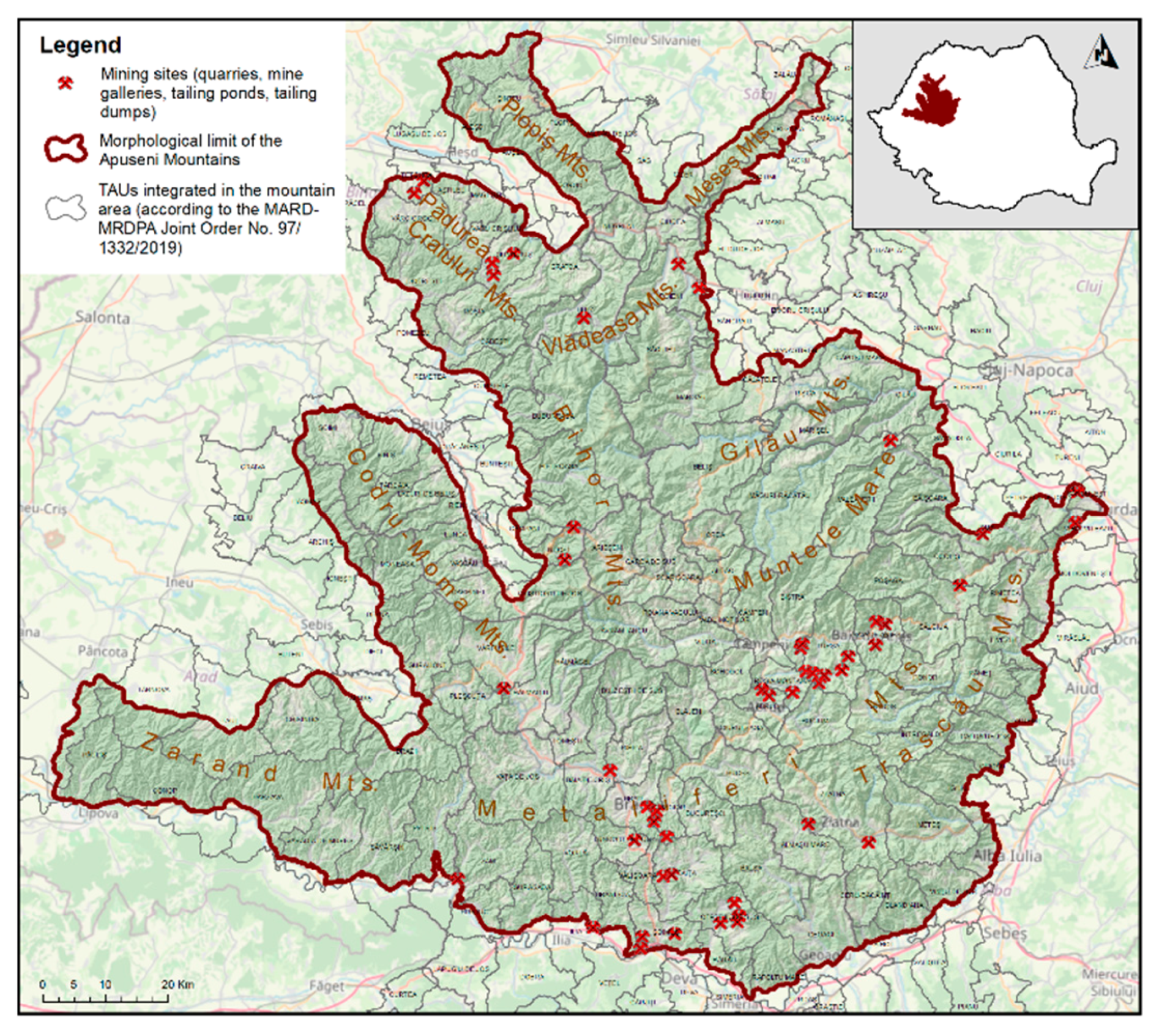
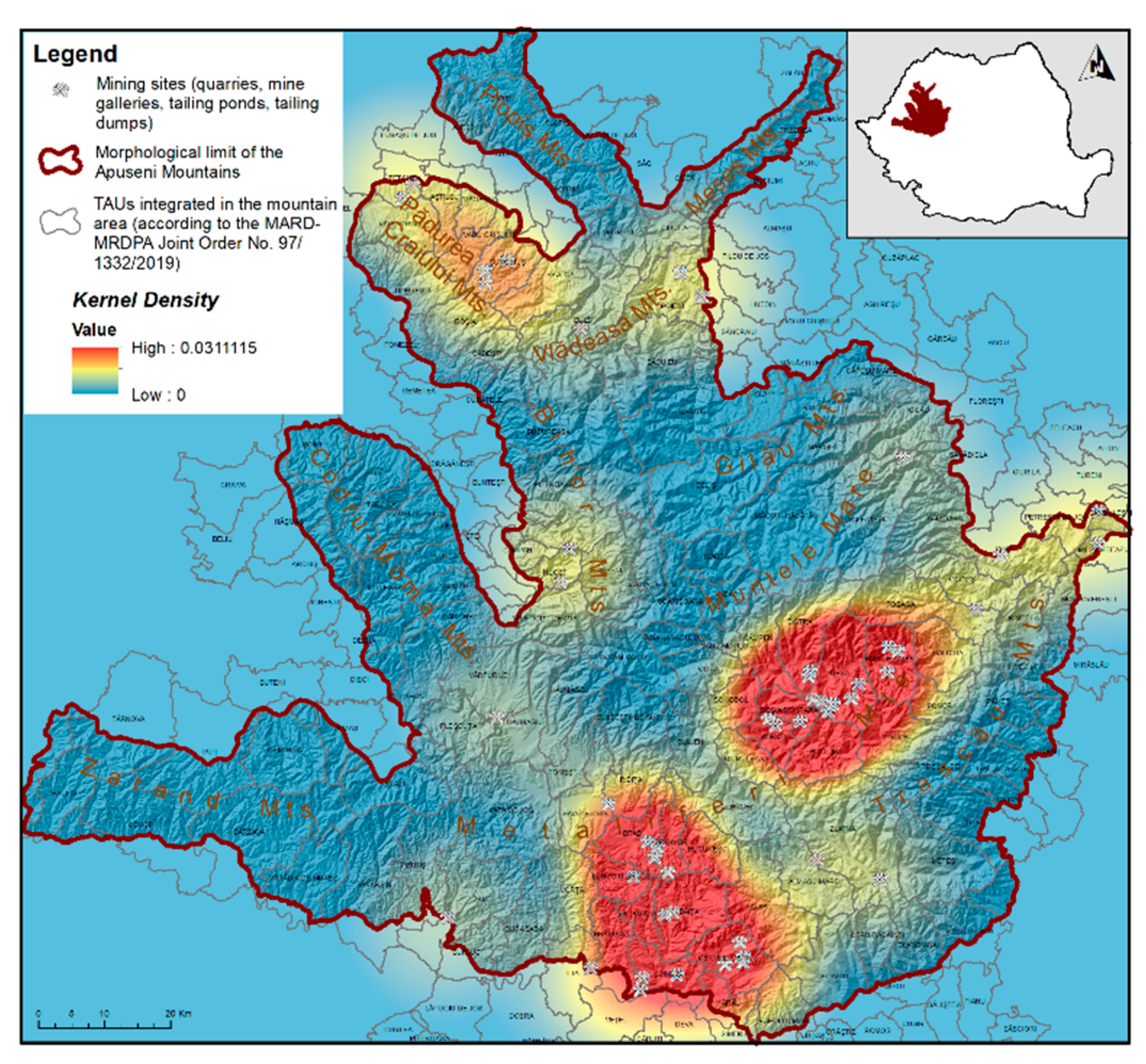
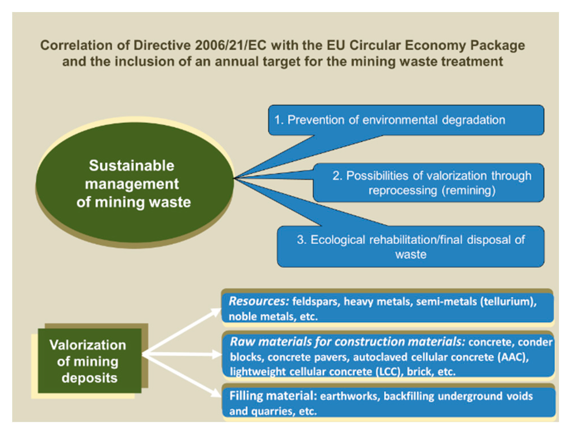
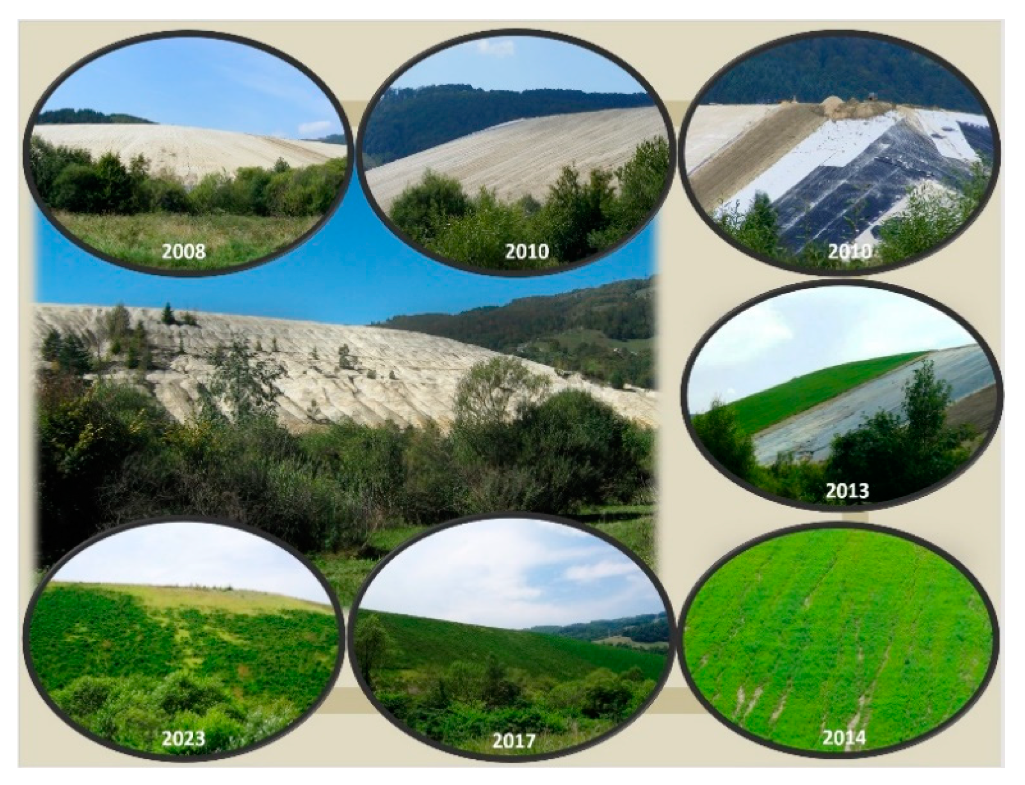
| Layer | Data format | Data processing software | Data source |
|---|---|---|---|
| DEM 1_12,5 m | raster | ArcGIS 10.8 | ALOS PALSAR RTC |
| UAT 2 limits | vector | ArcGIS 10.8 | ANCPI 5 |
| River network | vector | ArcGIS 10.8 | OSM 6 |
| Road network | vector | QGIS 3.6 Noosa | OSM |
| Protected areas | vector | ArcGIS 10.8 | ANPM 7 |
| Landsat 8 OLI_TIRS images (2023) |
raster | ERDAS 4 Imagine 16.8 |
USGS 8 |
| CORINE Land Cover (2018) | raster | ArcGIS 10.8 | EEA 9 |
| INS 3 data | .xml/.csv | Microsoft Excel/ ArcGIS 10.8 |
INSSE 10/ TEMPO-Online |
| Geological map of Romania (1:200 000) | raster | ArcGIS 10.8 | IGR 11 |
| Orthophotoplanes _0,5m (1:2000) | raster | ArcGIS 10.8 | ANCPI |
| Map of Romania's mineral resources (1:500 000) | raster | Global Mapper V 25.1 |
IGR |
| Limits of Romania's mountain area | vector | ArcGIS 10.8 | MADR 12 |
| Topographic map of Romania (1:50 000/ 1:25 000) | vector | ArcGIS 10.8 | ANCPI |
| Aerial images (2020-2024) | raster | ArcGIS 10.8 | Google Earth Pro |
Disclaimer/Publisher’s Note: The statements, opinions and data contained in all publications are solely those of the individual author(s) and contributor(s) and not of MDPI and/or the editor(s). MDPI and/or the editor(s) disclaim responsibility for any injury to people or property resulting from any ideas, methods, instructions or products referred to in the content. |
© 2024 by the authors. Licensee MDPI, Basel, Switzerland. This article is an open access article distributed under the terms and conditions of the Creative Commons Attribution (CC BY) license (http://creativecommons.org/licenses/by/4.0/).


