1. Introduction
The European Directive 2014/89/EU, of July 23rd [
1], 2014 which establishes a framework for the planning of maritime space, with a view to promoting the sustainable growth of maritime economies, the sustainable development of marine spaces and the use sustainable management of marine resources in the different coastal countries of the European Union and its transposition in 2017 through Royal Decree 363/2017, of April 8th [
2], opens in Spain the legal framework for the establishment of Marine Space Planning. This Royal Decree was issued in development of Law 41/2010, of December 29
th [
3], on the protection of the marine environment, in accordance with the provisions of its article 4.2, which establishes that the Government may approve common guidelines for all marine strategies in order to guarantee the coherence of its objectives, in various aspects including, in its section f), the management of activities that are carried out or may affect the marine environment.
Within this legislative framework, Royal Decree 363/2017, of April 8th, ordered the approval of five maritime space planning plans, one for each of the Spanish marine demarcations. These plans must serve to guarantee the sustainability of human activities at sea, and at the same time, facilitate the development of the maritime sectors, and the achievement of the objectives that these sectors have set, with special attention to those objectives established to fulfil the commitments of the European Green Deal [
4], the Paris Agreement [
5], the European Union (EU) Climate Change Adaptation Strategy [
6] and the EU Biodiversity Strategy to 2030 [
7], among others.
In the preparation of the maritime space planning plans, the procedure established in article 7 of Royal Decree 363/2017, of April 8th, has been followed, with full inter-administrative coordination, as well as promoting the participation of Stakeholders and the civil society.
2. Maritime Planning
Within this legislative framework, maritime planning comes from the hand of Royal Decree 150/2023 of February 28th [
8], which in its article 1 establishes the following object and purpose:
The purpose of this royal decree is to approve the five management plans of the five marine demarcations of Spain, in accordance with the provisions of Royal Decree 363/2017, of April 8th, which establishes a framework for the management of space maritime.
Maritime spatial planning plans are instrumental in promoting the sustainable growth of maritime economies, the sustainable development of marine spaces and the sustainable use of marine resources.
The purpose of the maritime space planning plans is to contribute to achieving the planning objectives established in accordance with article 5 of Royal Decree 363/2017, of April 8th.
The maritime space planning plans are part of the marine strategies, which is why they participate in their public and binding nature for public administrations and will not by themselves create rights or obligations for individuals or entities, so their approval or modification will not give rise to compensation in accordance with article 7.2 of Law 41/2010, of December 29th, on protection of the marine environment.
In its article 2 it establishes the scope of application:
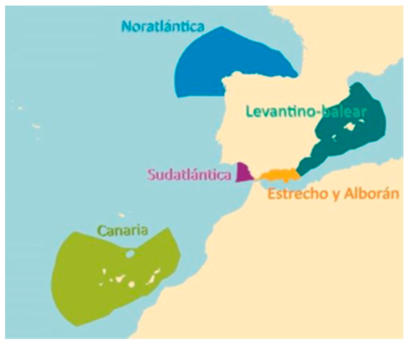
The scope of application of this royal decree is the five Spanish marine regions: North Atlantic, South Atlantic, Strait and Alboran, Levantine-Balearic and Canary Islands, defined in article 6.2 of Law 41/2010, of December 29th, on environmental protection. marine., and in the terms stipulated in article 2 of said Law.
The following are outside the scope of application of these plans:
Figure 1.
The five regions of the POEM. Source: Executive summary of the POEM. Ministry for the ecological transition and the demographic challenge. [
9].
Figure 1.
The five regions of the POEM. Source: Executive summary of the POEM. Ministry for the ecological transition and the demographic challenge. [
9].
a) Zones I and II of the ports of general interest of the State, as well as the service waters of the regional ports.
b) Coastal waters, in everything that is regulated in hydrological planning.
- 3.
Current planning and management regulations will predominantly apply to protected marine spaces, without prejudice to their classification in maritime space planning plans as areas of priority use for the conservation of biodiversity.
Also in its article 4, it establishes the content of the plans and their structuring:
a) Part common to all marine demarcations, contained in the annex to this royal decree, and comprising block I: context and scope of application; block II: guiding principles and management objectives; block IV: maritime space planning; block V: application, evaluation, and monitoring of plans; and the cartographic representation of the scope and zoning of the plans.
b)Specific part of each of the five marine demarcations, which is published only on the website of the Ministry for the Ecological Transition and the Demographic Challenge, and which includes block III: diagnosis: maritime sectors, current situation and forecasts of future development or potential. It is collected in five documents, one for each marine region: A. North Atlantic marine region [
10]; B. South Atlantic marine region [
11]; C. Marine region of the Strait and Alboran [
12]; D. Levantine-Balearic marine region [
13]; and E. Canarian marine region [
14].
These maritime space planning plans are abbreviated as POEM (Plan Ordenación Espacio Marítimo in Spanish) and today represent the Marine Spatial Planning instrument (MSP).
3. Status of Marine Spatial Planning and Terrestrial Spatial Planning
In the terrestrial part of Spain, spatial planning has highly developed instruments, which, based on the state land law and the regional land laws, organize the terrestrial space with different tools that fundamentally depend on the scale of the space that is being organized.
In general terms, we can distinguish between Urban Planning and Territorial Planning, establishing some differences that we will detail:
Terrestrial Spatial Planning: difference between Urban Planning and Territorial Planning. [
16]
The main criterion of distinction is the scale of work.
Urban Planning focuses on planning and management at the municipal level.
Territorial Planning at the supra-municipal level deals with the different sectoral infrastructures (coastline, industry, railways, roads, service and telecommunications networks, and ports).
-
Urbanism includes:
- ○
Development planning (PGOU, Partial Plans, Special Plans, Interior Reform Plans, Detailed Studies, etc.)
- ○
Urbanization projects
- ○
Drafting of parcelling projects and different urban management processes
- ○
Territorial Planning assumes:
- ○
Sectoral Guidelines (Coastal, industrial land, agricultural land, railways, roads, service and telecommunications networks, ports)
- ○
Territorial analysis and diagnosis (Territorial impact studies, Territorial Planning Plans, Actions of Regional Interest)
- ○
Environmental Strategies.
- ○
Strategic policies of the territory
On the other hand, the analysis of Marine Spatial Planning, as defined in the POEM, shows: [
9]
Prior to the publication of the POEM, the urban planning and territorial planning theory ended in the
Maritime Land Public Domain (Regulated by the State and Autonomous Coast Law) [
17,
18,
19,
20,
21,
22,
23,
24,
25,
26,
27] and in the Ports (State Port Law or Autonomous Port Laws) [
28].
-
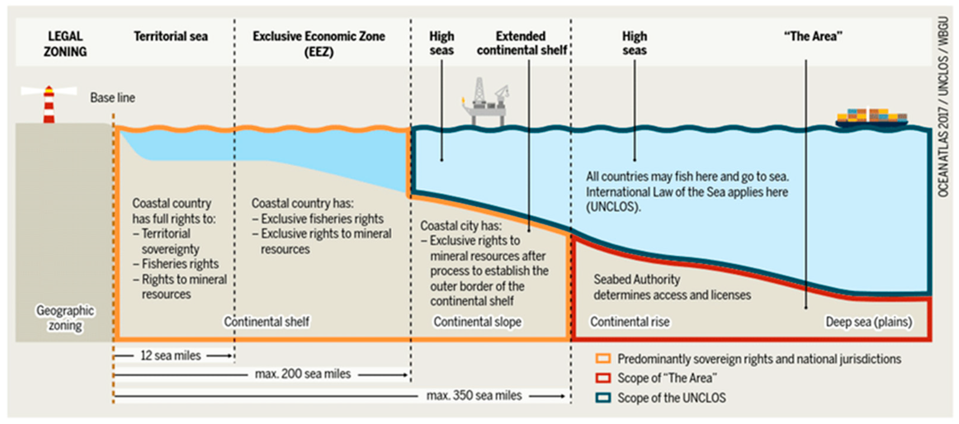
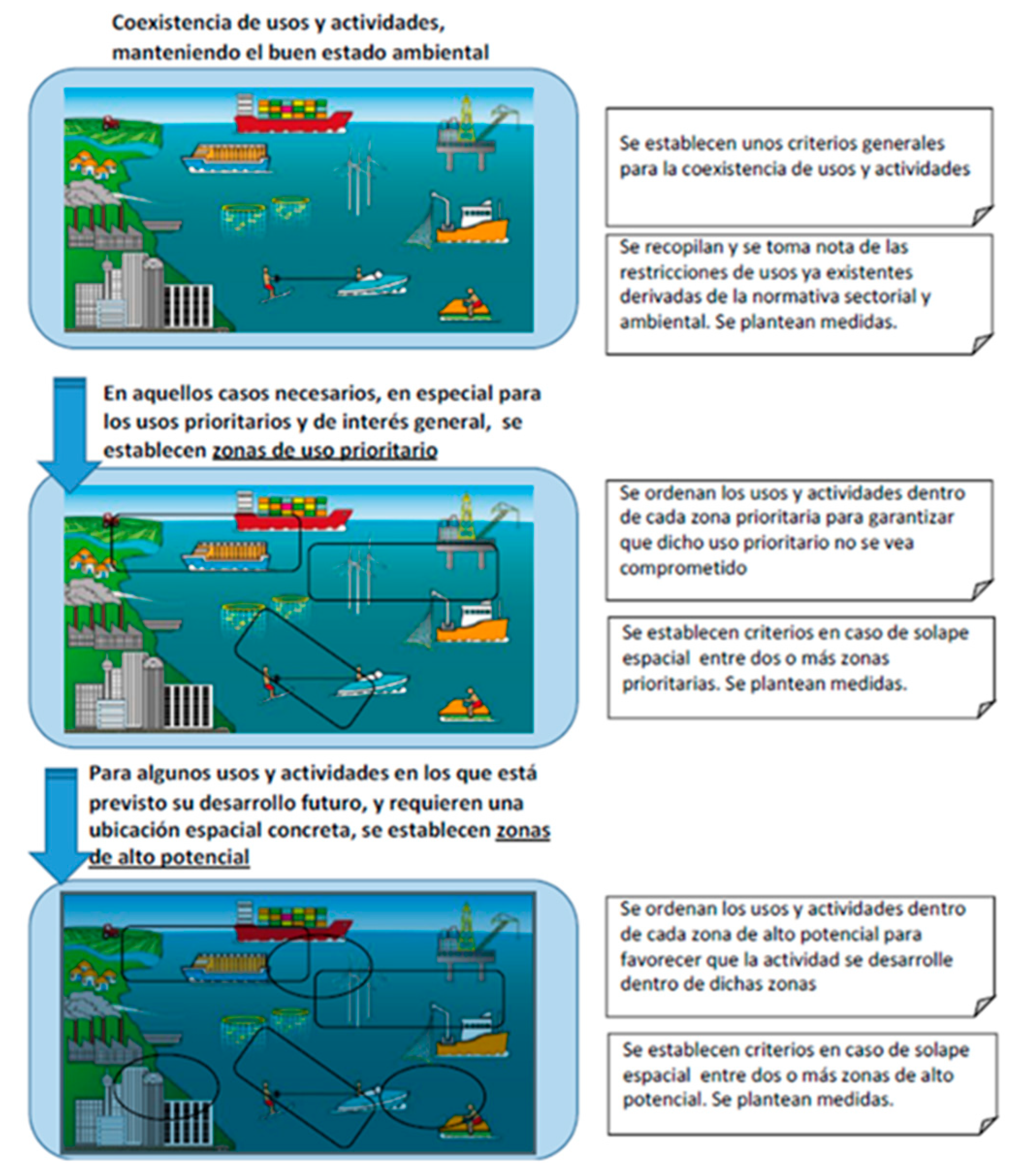
With the publication of the POEM, zoning by uses is carried out, under the principle of coexistence, which extends to the Exclusive Economic Zone (EEZ 200 miles from the coast), producing a widening of the Territory. Zoning distinguishes:
- ○
Areas of General Interest
- ○
Priority Use Areas
- ○
High Potential Areas
- ○
Protected Areas
General criteria are established for the coexistence of uses and activities.
There are restrictions on uses derived from sectoral and environmental regulations.
Uses and activities are ordered within each priority use zone and high potential zone, to guarantee that said priority or high potential uses are not compromised.
Criteria are established in case of spatial overlap of two or more priority areas or high potential areas.
There are no small-scale instruments, such as in Terrestrial Spatial Planning.
Figure 3.
Scheme of coexistence of uses proposed by the POEM. Source: Ministry for the Ecological Transition and the Demographic Challenge. [
9].
Figure 3.
Scheme of coexistence of uses proposed by the POEM. Source: Ministry for the Ecological Transition and the Demographic Challenge. [
9].
From the comparison of both Plans two conclusions can be obtained:
The first is that in the very recently created marine spatial planning (POEM), there are no instruments homologous to those of terrestrial spatial planning, which we call territorial planning.
The second is that although ports, coasts and the terrestrial maritime public domain are considered in terrestrial spatial planning, their consideration is more on the side of the reservation of powers than their inclusion in said order.
From the previous analysis it is deduced that the Coastal Strip, understood as sea-land interaction, does not have a consideration in either of the two plans. It is true that the POEM takes this interaction into account, but as occurs with terrestrial planning, the spatial zone of influence between the sea and the land, nor their interactions in the face of it, are not considered together with the latter to the organization of space. This area of special importance, since a large part of the population lives in coastal areas, in Spain about 40% of the population, should be the subject of a specific analysis, which could be covered by an Integration of Marine Planning and Land Planning.
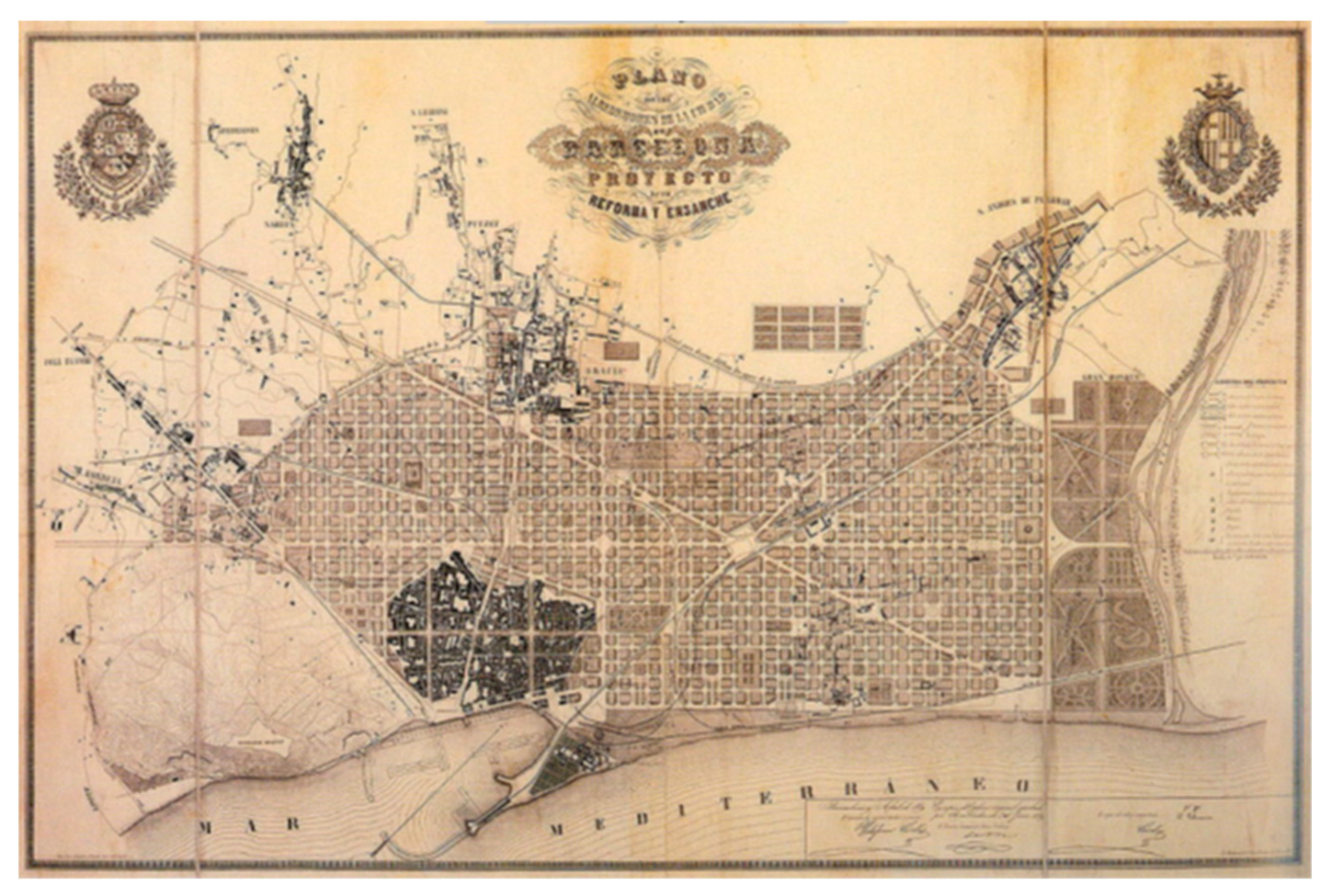
Figure 4.
Cerdá Plan in Barcelona. Source: City History Museum, Barcelona. Fuente [
16].
Figure 4.
Cerdá Plan in Barcelona. Source: City History Museum, Barcelona. Fuente [
16].
It can be seen in the photo that, despite the training of the illustrious Mr. Ildefonso Cerdá as a Civil, Canal and Port Engineer, his masterful planning of the city of Barcelona was carried out with his back to the sea.
4. Need for Integration of Marine Planning and Land Planning
We can establish
the origins of Marine Planning in the Marine Protected Area Plans (MPA). The first protected area was established in Australia in 1879 Alvarez Romero [
29], however, it did not evolve until The Great Barrier Reef Marine Park Act was published in 1975 [
30]. In 1987 The Great Barrier Reef Zoning Plan was implemented [
31]. In 2002 The China's National Marine Zoning Plan [
32], in 2003 the Belgium's Master (zoning) Plan for the EEZ [
33] and finally in 2006 the first workshop on Marine Spatial Planning took place within the
International Oceanographic Commission (IOC) of UNESCO [
34]. In 2009 this organization published the Marine Spatial Planning Guide A step by step approach [
35], which is based on ecosystem-based management EBM (Ecosystem Based Management). With European Directive 2014/89/EU, of July 23
rd [
2], this trend of Maritime Space Planning based on ecosystems is now defined as Maritime Space Planning of integrated uses. This distinction is also evident in terminology, since the EU speaks of MSP, while UNESCO speaks of EBM to refer to Ecosystem-Based Planning.
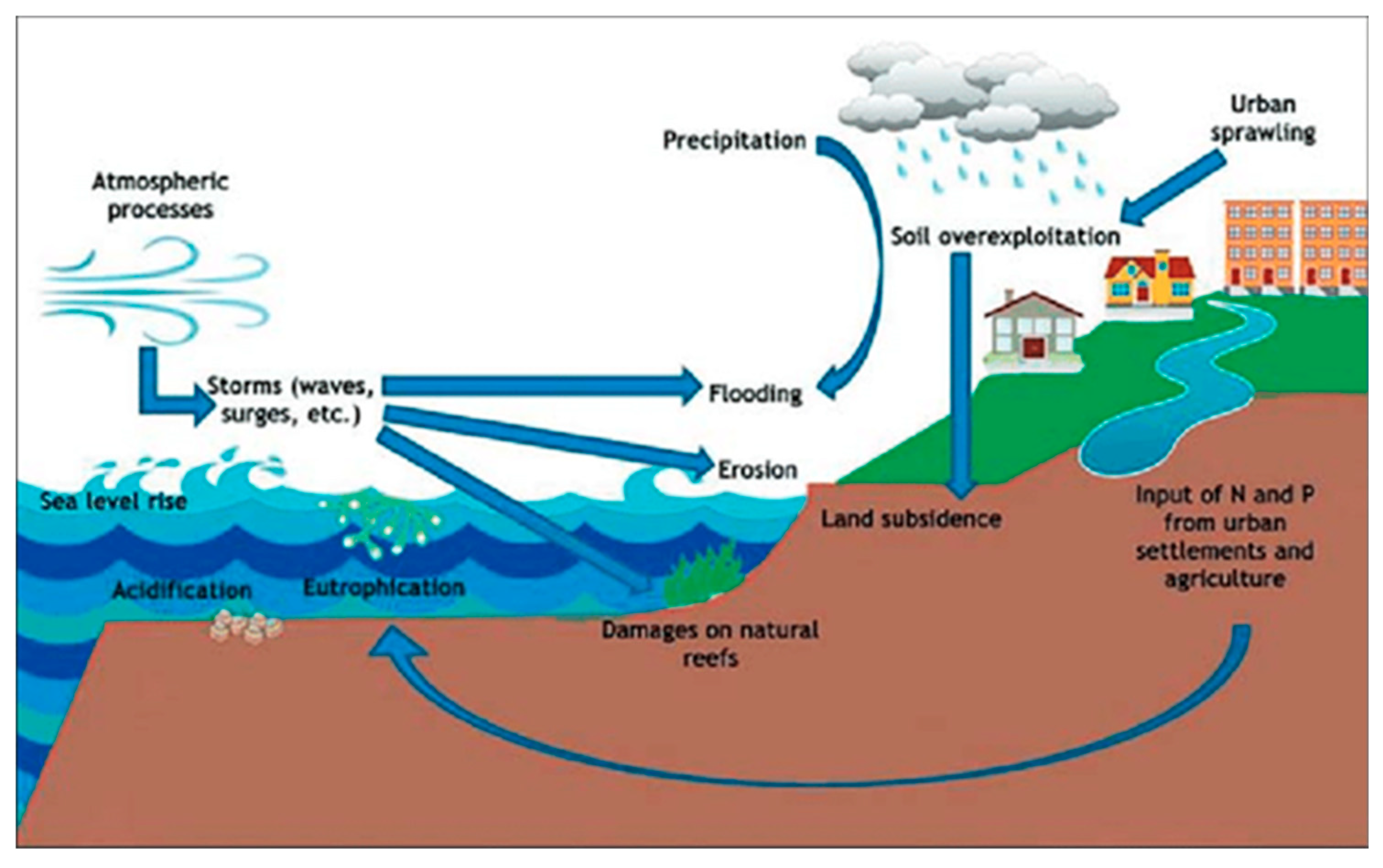
Figure 5.
Interactions between sea and land affect the coastal system. Source: Response to Climate Change in Coastal and Marine Protected Areas: Threats and Opportunities (2020) Vitelletti, Maria Letizia, Bonaldo Davide. SP61 SN 978 88 8080 402 4. ResearchGate.[
36].
Figure 5.
Interactions between sea and land affect the coastal system. Source: Response to Climate Change in Coastal and Marine Protected Areas: Threats and Opportunities (2020) Vitelletti, Maria Letizia, Bonaldo Davide. SP61 SN 978 88 8080 402 4. ResearchGate.[
36].
As the reader can deduce, since Marine Space Planning (POEM) and Terrestrial Space Planning (Territorial Planning) are available, these two systems should converge and integrate. Even more so when there is a sea-land interaction that has great implications and influences between both areas, marine and terrestrial. The existence of a joint management tool is evident, since at least up to the Exclusive Economic Zone (EEZ) the joint surface of the marine space and the terrestrial space must be managed as a common area that is under the management of the State. Note that while
the land surface of Spain is 506,030 km2 [
37], when considering the entire EEZ
the marine surface is 1,039,233 km2 [
38], that is, practically double the land surface. Which is of capital importance in the Spanish State, and which justifies, therefore, the consideration of
Integrated Space Planning, for its joint management.
5. Approach to the Integration of Marine Planning and Land Planning, Configuring the Tool Called Integrated Space Planning
A first analysis must start from the state of the art, both in the academic world and in the practice of integration in international references:
USA [
39], Europe, Japan, China and Australia.
Secondly, we must raise why integration is important.
Thirdly, we must see what challenges the integration of both plans poses and move forward in their solution.
5.1. State of the Art of the Integration of Sea-Land Planning
This study will analyse both academic literature and practice in different international references [
40]
Ideas common to all integration methods will be obtained.
Unanalysed gaps will be identified and, therefore, the challenges that must be faced in the scientific advancement of integration.
5.2. What Is the Importance of the Integration of Sea-Land Planning? (Alvarez Romero (2011) Classification of Interactions Is Followed [29])
Natural effects and ecological processes:
- -
From sea to land
- -
From land to sea
- -
Threats that originate in one of the areas (land or sea) and their impact on the other area because of human activity
- -
The effects of human actions and their social, economic, and cultural impacts in both areas
5.3. How to Carry Out and What Challenges Does the Integration of Sea-Land Planning Pose, to Constitute Integrated Space Planning? [40]
Currently there is no academic or practical consensus.
There are different approaches:
One of the first approaches to minimizing sea-land conflict is through the integration of coastal zone management, which views management policies and coastal ecosystems in a holistic way. Although this approach leaves out many of the sea-land interactions
Alvarez Romero (2015) [
41] defines an operational framework for Sea-Earth spatial planning in which he defines a series of critical components that need to be considered at the same time in both planning: communities involved, governance analysis, mapping of the different uses, establishment of objectives, characteristics and threats of the model and evaluation of a benefits and compensation system.
Tallis, Ferdana and Gray (2008) [
42] classify three levels of integration: concurrency, simultaneity, and integration. However, it recognizes that total integration is not possible given the great difference between both plans.
Current and future challenges:
Marine and terrestrial planning are different in several dimensions; therefore, their integration poses different challenges.
We can establish two large blocks:
5.3.1. Political and Institutional Aspects of Integration [43,44]
Both plans depend on different organizations at both the national and regional levels.
Therefore, a coordinator of both planning and its development instruments is necessary. Two proposals: either a national coordinating body (or one by demarcation) contemplated in the POEM, or the city is established as an integration centre (since the city is the nucleus of terrestrial urban development).
5.3.2. Limitations and Technical Challenges [40]
Difficulty of having reliable data and models due to the high cost of obtaining them
Difficulty in fully understanding sea-land dynamics in the three aspects defined by Álvarez Romero.
Difficulty of the process of sharing this complex information
Marine and terrestrial planning are carried out at different scales, which makes decision making difficult.
Finally, instruments for the development of terrestrial planning are non-existent in marine planning.
6. Proposal of Steps to Follow
One way to achieve the integration of both Planning is the definition of homologous instruments in both.
The line of work can be based on how these instruments could be defined in the POEM. (equivalences between the different instruments of territorial planning and urban planning, to the extent that they make sense, “we should not put doors to the countryside (sea)”).
Once these instruments are defined, it will be easier to achieve parallelism and, therefore, the integration of the MSP and TSP.
This analysis must be contrasted with that of integration methods in other countries, trying to identify common elements, so that, to the extent possible, our planning is easily integrated with future planning in international waters.
At the same time, an administrative management model must be proposed that is competent in integration at three scales:
National scale: coordination centre for the integration of maritime and land planning in each of the marine regions.
Regional scale: coordination centre for the integration of land-maritime planning in each CCAA.
Municipal scale: the city will have to include maritime planning in its land planning and integrate both.
The collegiate bodies defined by the POEM: Interministerial Commission of Marine Strategies, Monitoring Committees (AGE and CCAA) and the Government Delegate Commission for Economic Affairs, are dedicated to the evolution of the PEM and leave aside the integration of both plans.
Once the integration model has been identified and proposed, this will be the basis for the study of the activities and design of coastal cities, both for their growth and for their protection against the effects of extreme events and rising or retreating sea levels. caused by climate change. It should also serve to prepare coastal cities against disastrous dangers, such as hurricanes and, more importantly in Spain, the event of possible tsunamis [
45,
46]
All the above must be done considering the time variable, defining different evolution scenarios due to climate change [
47].
The introduction of the temporal variable will make us turn to planning models that are adaptive to the new configurations of the coasts [
48]. That is, Integrated Spatial Planning must foresee the change in the coastal configuration and the evolution of its effects due to extreme events. Therefore, ultimately municipal planning will be conditioned to said change in coastal configuration and the changing effects of extreme events.
We see how Integrated Space Planning is configured as the necessary tool for the joint management of the territory.
Future lines of research will configure this tool. Its use and feedback on the processes will polish it towards an increasingly refined and useful tool.
7. Conclusions
Maritime Space Management Plans (POEM) constitute a Marine Space Planning tool based on uses, compared to other ecosystem-based management tools (EBM). This tool responds to the EU guidelines to promote the sustainable growth of maritime economies, the sustainable development of marine spaces and the sustainable use of marine resources.
Given the importance of the Coastal Strip in terms of the large population that lives in it, it is necessary to be able to jointly manage this area with a tool that integrates Maritime Space Planning and Land Space Planning. We can call this tool Integrated Space Planning.
Integrated Space Planning will be the tool that will serve for the total management of the territory, including the EEZ and with it, both the sea-land interaction and the critical variables of the evolution of climate change will be analysed [
49]. Serving as a basis for managing the rise or fall of sea level, conditions caused by extreme events and preparation for disastrous dangers, such as hurricanes, tsunamis, or earthquakes.
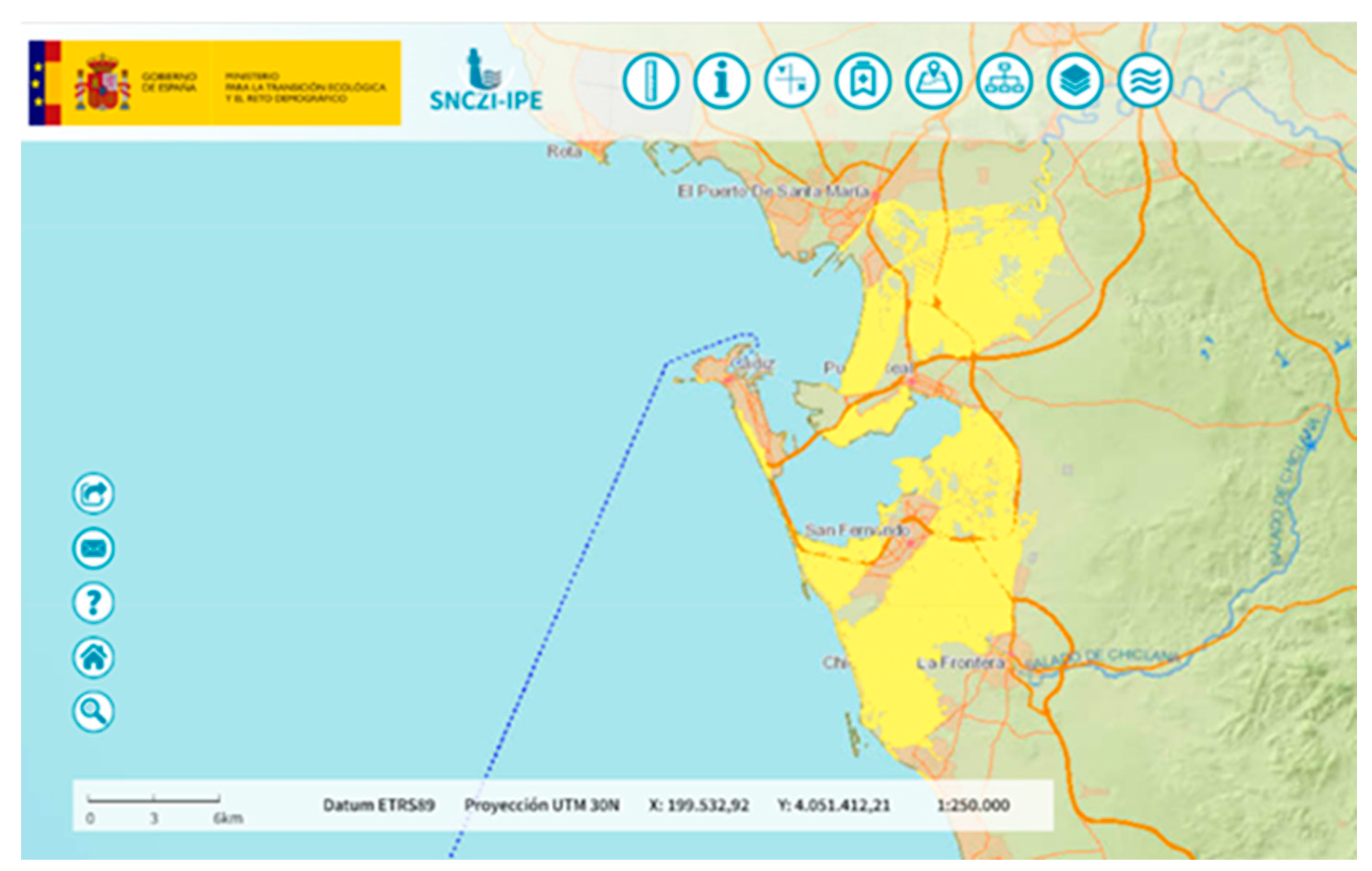
Figure 6.
Example of cartography of a flood zone with a flood with a return period T=100 years and a marine flood zone with a storm with a return period T=100 years. Source: National Flood Zone Mapping System.
http://sig.mapama.es/snczi/ [
50].
Figure 6.
Example of cartography of a flood zone with a flood with a return period T=100 years and a marine flood zone with a storm with a return period T=100 years. Source: National Flood Zone Mapping System.
http://sig.mapama.es/snczi/ [
50].
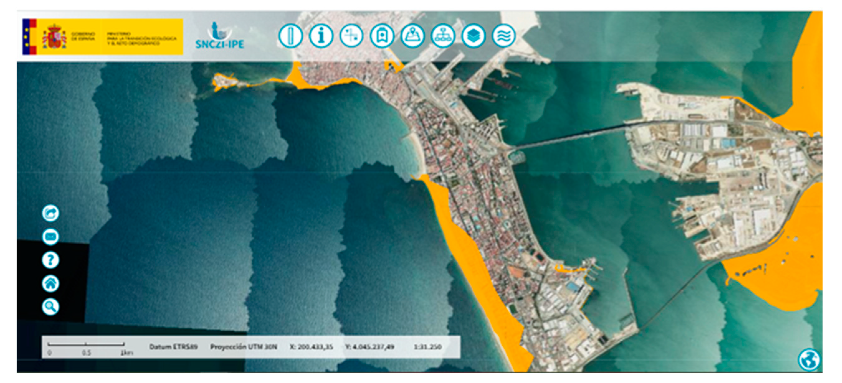
Figure 7.
Expansion of cartography and satellite view of the city of Cádiz. It can be seen how the.flood zones with the characteristics of figure 6 affect the urban development of the city of Cádiz. Source: National Flood Zone Mapping System.
http://sig.mapama.es/snczi/ [
50].
Figure 7.
Expansion of cartography and satellite view of the city of Cádiz. It can be seen how the.flood zones with the characteristics of figure 6 affect the urban development of the city of Cádiz. Source: National Flood Zone Mapping System.
http://sig.mapama.es/snczi/ [
50].
NOTE.- The POEMs address the topic of sea-land interaction with a description, characterization of the process, description of the activities that cause the interaction, its relevance in marine demarcation and planning tools that address the topic but do not deal with integration. of the planning: “The POEM of the South Atlantic Demarcation can contribute to the identification and dissemination of interactions, in such a way that the need to seek comprehensive solutions is established and integrated management is promoted between all administrations with powers in the preservation of "the good quality of the environment, promoting the awareness of the economic sectors involved and seeking their collaboration." “The POEM and its successive updates may function as “sentinels”.
Author Contributions
F.J.C.D contributed to the work described in this paper by carrying out the analysis and evolution of Marine Spatial Planning (MSP) along the history. Comparing different approaches developed in different Countries and proposing one alternative of evolution of Marine Spatial Planning in Spain and their integration with Terrestrial Spatial Planning (TSP). V.N.V contributed organizing the development of the article, clarifying specialized concepts and the introducing the relationships between the climate change and the Spatial Planning, both marine and terrestrial. G.G.P, J.J.M and L.J.M.B. contributed with knowledgeable discussion and suggestion.
References
- DIRECTIVE 2014/89/EU OF THE EUROPEAN PARLIAMENT AND OF THE COUNCIL OF 23 JULY 2014 establishing a framework for maritime spatial planning.
- ROYAL DECREE 363/2017, OF APRIL 8th, which establishes a framework for maritime spatial planning and ordered the approval of five maritime space management plans, one for each of the Spanish marine regions.
- LAW 41/2010, OF DECEMBER 29th, on the protection of the marine environment.
- THE EUROPEAN GREEN DEAL (EGD), APPROVED IN 2020, is a set of policy initiatives of the European Commission with the overall objective of making the European Union (EU) climate neutral by 2050.
- THE PARIS AGREEMENT, SIGNED ON APRIL 22nd, 2016. Is an agreement within the framework of the United Nations Framework Convention on Climate Change that establishes measures to reduce greenhouse gas (GHG) emissions. The agreement seeks to maintain the increase in global temperature average below 2°C above pre-industrial levels and pursue efforts to limit the increase to 1.5°C, recognizing that this would significantly reduce the risks and effects of climate change.
- https://climate.ec.europa.eu/eu-action/climate-strategies-targets/2050-long-term-strategy_en. Striving to become the world's first climate-neutral continent by 2050.
- https://environment.ec.europa.eu/strategy/biodiversity-strategy-2030_en. The EU’s biodiversity strategy for 2030 is a comprehensive, ambitious and long-term plan to protect nature and reverse the degradation of ecosystems. The strategy aims to put Europe's biodiversity on a path to recovery by 2030 and contains specific actions and commitments.
- ROYAL DECREE 150/2023, OF FEBRUARY 28th, 2023, approving the maritime spatial management plans of the five Spanish marine regions.
- Executive summary of the POEM. Ministerio para la Transición Ecológica y el RetoDemográfico. https://www.miteco.gob.es/content/dam/miteco/es/costas/temas/proteccion-medio-marino/4resumenejecutivopoem_tcm30-552786.pdf.
- POEM North Atlantic marine region. Ministerio para la Transición Ecológica y el Reto Demográfico. https://www.miteco.gob.es/es/costas/temas/proteccion-medio-marino/ordenacion-del-espacio-maritimo.html.
- POEM South Atlantic marine region. Ministerio para la Transición Ecológica y el Reto Demográfico. https://www.miteco.gob.es/es/costas/temas/proteccion-medio-marino/ordenacion-del-espacio-maritimo.html.
- POEM Marine region of the Strait and Alborán. Ministerio para la Transición Ecológica y el Reto Demográfico. https://www.miteco.gob.es/es/costas/temas/proteccion-medio-marino/ordenacion-del-espacio-maritimo.html.
- POEM Levantine-Balearic marine region. Ministerio para la Transición Ecológica y el Reto Demográfico. https://www.miteco.gob.es/es/costas/temas/proteccion-medio-marino/ordenacion-del-espacio-maritimo.html.
- POEM Canarian marine region. Ministerio para la Transición Ecológica y el Reto Demográfico. https://www.miteco.gob.es/es/costas/temas/proteccion-medio-marino/ordenacion-del-espacio-maritimo.html.
- BAS BOLMAN, ARJEN BOON, CHRISTOPHE BRIÈRE, CEES VAN DE GUCHTE, THEO PRINS, ERWIN ROEX, CLAUDETTE SPITERI, JOANA MIRA VEIGA, DICK VERHAAK. 11200587-000-ZWS-0003, 2 February 2018, final. Deltares, 017 B. https://www.researchgate.net/publication/331928317_Oceans_Report_-_Addressing_SDG14_issues_with_factual_data_and_state_of_the_art_knowledge.
- GARCÍA-AYLLÓN VEINTIMILLA, SALVADOR (2014) Urbanismo y ordenación del territorio. Manual de teoría. Escuela Universitaria de Ingenieros de Caminos, Canales y Puertos. Universidad Politécnica de Cartagena.
- Law 22/1988, of July 28th, on Coasts.
- Law 2/2013, of May 29th, on the protection and sustainable use of the coastline and on the modification of Law 22/1988, of July 28th, on Coasts.
- Royal Decree 876/2014, of October 10th, which approves the General Coastal Regulation.
- Royal Decree 668/2022, of August 1st, which approves the General Coastal Regulation Modification.
- SALA DE LO CONTENCIOSO ADMINISTRATIVO DEL TRIBUNAL SUPREMO. Comunicación del Poder Judicial. Thursday February 8, 2024. The Supreme Court annuls the Royal Decree that reformed the General Coastal Regulation in 2022 due to omission of the public consultation process.
- Royal Decree 713/2022, of August 30th, on the transfer of functions and services from the General Administration of the State to the Autonomous Community of the Canary Islands in matters of coastal planning and management.
- Law 8/2020, of July 30th, on the protection and management of the coastline. Transfer of functions and services from the General Administration of the State to the Autonomous Community of the Catalonia in matters of coastal planning and management.
- Royal Decree 62/2011, of January 21st, on the transfer of functions and services from the State Administration to the Autonomous Community of Andalusia in matters of coastal planning and management.
- Royal Decree 994/2022, of November 29th, transferring functions and services from the State Administration to the Autonomous Community of the Balearic Islands in matters of coastal planning and management.
- Law 4/2023, of July 6th, on the planning and integrated management of the Galician coastline.
- https://www.lavozdegalicia.es/noticia/galicia/2023/11/15 The Government guarantees the PNV the management of the coastline for which it has taken Galicia to the Constitutional Court.
- ROYAL LEGISLATIVE DECREE 2/2011, OF SEPTEMBER 5, which approves the Consolidated Text of the Law on State Ports and the Merchant Navy.
- ALVAREZ ROMERO, JORGE G., ROBERT L. PRESSEY, NATALIE C. BAN, KEN VANCE-BORLAND, CHUCK WILLER, CARISSA JOY KLEIN AND STEVEN D. GAINES (2011) Integrated Land-Sea Conservation Planning: The Missing Links. The Annual Review of Ecology, Evolution, and Systematics.
- AUSTRALIAN GOVERNMENT FEDERAL REGISTER OF LEGISLATION. Great Barrier Reef Marine Park Act 1975. No. 85, 1975. Compilation No. 32. Compilation date: 24 August 2017. Includes amendments up to: Act No. 89, 2017. Registered: 5 September 2017.
- GREAT BARRIER REEF MARINE PARK AUTHORITY. AUSTRALIAN GOVERNMENT. Central Section Zoning Plan: Great Barrier Reef Marine Park 1987. ISBN: 9780642525536.
- PROFESSOR PhD. TENG XIN. Marine Spatial Planning Academy, China Oceanic Development Foundation. China Marine Functional Zoning approved in August 2002 by The China State Council. China Marine Functional Zoning and the Data Support.
- VERHALLE, JESSE. MARINE ENVIRONMENT SERVICE. FEDERAL PUBLIC SERVICE HEALTH, FOOD CHAIN SAFETY AND ENVIRONMENT, BELGIUM. North Sea Master Plan 2003.
- INTERGOVERNMENTAL OCEANOGRAPHIC COMMISSION (IOC) UNESCO. 2nd International Conference on Marine/Maritime Spatial Planning. 15-17 March 2017. Paris France. IOC workshop reports series 279.
- EHLER, CHARLES; DOUVERE, FANNY. IOC MANUALS AND GUIDES. INTERGOVERNMENTAL OCEANOGRAPHIC COMMISSION (IOC) UNESCO. Marine Spatial Planning: a step-by-step approach toward ecosystem-based management.
- VITELLETTI, MARIA LETIZIA, BONALDO DAVIDE (2020) Response to Climate Change in Coastal and Marine Protected Areas: Threats and Opportunities. SP61 SN 978 88 8080 402 4. ResearchGate.
- INSTITUTO GEOGRÁFICO NACIONAL, MINISTERIO DE TRANSPORTES MOVILIDAD Y AGENDA URBANA. GOBIERNO DE ESPAÑA. Superficie Terrestre de España.
- INSTITUTO GEOGRÁFICO NACIONAL, MINISTERIO DE TRANSPORTES MOVILIDAD Y AGENDA URBANA. GOBIERNO DE ESPAÑA. El medio marino en la ZEE de España. 2005. Segunda Edición.
- GÓMEZ PINA, GREGORIO (1997) La gestión integral de la costa en Estados Unidos: aspectos positivos a considerar en el modelo español. I Congreso de la Ingeniería Civil, Territorio y Medio Ambiente. Editorial Colegio de Ingenieros de Caminos, Canales y Puertos. Año 2002. ISBN 978-84-380-0210-0. Páginas 441-457.
- SIR NINDYO MAMOLA, JEREMIA (2019) Towards the Integration of Terrestrial and Marine Spatial Planning in Indonesia. A Case Study of Bali. Department of Urban Studies and Planning. Massachusetts Institute of Technology.
- ALVAREZ-ROMERO, JORGE G., VANESSA M. ADAMS, ROBERT L. PRESSEY, MICHAEL DOUGLAS, ALLAN P. DALE, AMELIE A. AUGE, DEREK BALL, ET AL. (2015). “Integrated Cross-Realm Planning: A Decision-Makers’ Perspective.” Biological Conservation 191: 799–808.
- TALLIS, HEATHER, ZACH FERDAÑA, AND ELIZABETH GRAY. 2008. “Linking Terrestrial and Marine. Conservation Planning and Threats Analysis.” Conservation Biology 22 (1): 120–30. [CrossRef]
- OSTROM, ELINOR (1990) Governing the Commons: The Evolution of Institutions for Collective Action. Cambridge: Cambridge University Press.
- OSTROM, ELINOR (2011) Background on the Institutional Analysis and Development Framework the Policy Studies Journal 39.
- GÓMEZ PINA, GREGORIO (2015) ¿Qué es un tsunami?: importancia de la educación ciudadana. IERD El riesgo de maremotos en la Península Ibérica a la luz de la catástrofe del 1 de noviembre de 1755.
- GONZÁLEZ RODRÍGUEZ, MAURICIO (2015) Desarrollo de metodologías para el cálculo del riesgo por tsunami y aplicación para el caso de Cádiz. IERD El riesgo de maremotos en la Península Ibérica a la luz de la catástrofe del 1 de noviembre de 1755.
- NEGRO, VICENTE; SANTOS LÓPEZ-GUTIERREZ, JOSÉ; ESTEBAN, MARIA DOLORES; DEL CAMPO, JOSÉ MARÍA Y LUENGO, JORGE (2018) Action Strategy for Studying Marine and Coastal Works with Climate Change on the Horizon. Journal of Coastal Research, Special Issue No. 85, pp. 506–510.
- NEGRO, VICENTE; SANTOS LÓPEZ-GUTIERREZ, JOSÉ; ESTEBAN, MARIA DOLORES; DEL CAMPO, JOSÉ MARÍA Y MARTÍN-ANTÓN, MARIO (2016) Review of coastal Land Reclamation situation in the World. Journal of Coastal Research, Special Issue, No. 75, pp. 667-671.
- CRUZ-RAMÍREZ, CESIA J.; CHÁVEZ, VALERIA; SILVA, RODOLFO; MUÑOZ-PÉREZ, JUAN J.; RIVERA-ARRIAGA, EVELIA. (2024) Coastal Management: A Review of Key Elements for Vulnerability Assessment. Journal of Marine Science and Engineering. MDPI. J. Mar. Sci. Eng. 2024, 12, 386, https://www.mdpi.com/journal/jmse. [Google Scholar] [CrossRef]
- SISTEMA NACIONAL DE CARTOGRAFÍA DE ZONAS INUNDABLES. MINISTERIO PARA LA TRANSICIÓN ECOLÓGICA Y EL RETO DEMOGRÁFICO. GOBIERNO DE ESPAÑA.
|
Disclaimer/Publisher’s Note: The statements, opinions and data contained in all publications are solely those of the individual author(s) and contributor(s) and not of MDPI and/or the editor(s). MDPI and/or the editor(s) disclaim responsibility for any injury to people or property resulting from any ideas, methods, instructions or products referred to in the content. |
© 2024 by the authors. Licensee MDPI, Basel, Switzerland. This article is an open access article distributed under the terms and conditions of the Creative Commons Attribution (CC BY) license (http://creativecommons.org/licenses/by/4.0/).
