Submitted:
22 April 2024
Posted:
23 April 2024
You are already at the latest version
Abstract
The flourishing landscape of agritourism in Albania has witnessed a steady increase in destinations over the years. Recognizing their pivotal role in driving economic development in rural areas, considerable attention is directed towards the promotion and expansion of these agricultural tourism spots. To enhance interactivity with visitors, these agritourism destinations actively leverage social networks and various digital platforms. However, the wealth of information pertaining to these destinations is currently scattered across different platforms, posing a challenge to accessibility. To address this issue, these points are strategically placed on Google Maps, along with essential details collected from users, such as websites, contact numbers, visitor ratings, and comments. Nevertheless, other valuable data remains dispersed on various social networks. In response to this fragmentation, this study proposes the development of algorithms and scripts to systematically collect and analyze this dispersed information. By doing so, the goal is to centralize and streamline the data, enabling a comprehensive understanding of the agritourism landscape in Albania. This approach not only facilitates efficient access to information for potential visitors but also provides valuable insights for stakeholders involved in the development and management of these agritourism destinations. The study aims to contribute to the sustainable growth of agritourism in Albania by harnessing the power of digital platforms to create a unified and organized database. Through this integration, the research seeks to unveil patterns, trends, and opportunities that can further guide policy-making, marketing strategies, and overall decision-making processes in the realm of agritourism development.
Keywords:
Agritourism
; Social networks
; Digital platforms
; Google Maps
; Data collection
; Data analysis
1. Introduction
In recent years, the agritourism landscape in Albania has undergone a remarkable transformation, witnessing a substantial increase in destinations that play a pivotal role in driving economic development within rural areas. The recognition of the economic significance of these agricultural tourism spots has fueled a dedicated effort towards their promotion and expansion. In this dynamic environment, agritourism destinations are not merely static entities but actively engage with visitors through social networks and various digital platforms, enhancing interactivity and connectivity.
Despite the progressive strides in promoting these destinations, a significant challenge arises from the scattered nature of information across different platforms. This dispersion poses a hurdle to accessibility, hindering the potential of these agritourism spots. Acknowledging this challenge, a strategic initiative has been undertaken to map these points on Google Maps, incorporating essential details garnered directly from users, including websites, contact numbers, visitor ratings, and comments. However, a wealth of valuable data continues to be dispersed across various social networks, creating a fragmented information landscape.
To address this fragmentation, this study advocates for the development of algorithms and scripts designed to systematically collect and analyze the dispersed information. The primary objective is to centralize and streamline this data, fostering a comprehensive understanding of the agritourism landscape in Albania. This approach not only facilitates efficient access to information for potential visitors but also unlocks valuable insights for stakeholders engaged in the development and management of these agritourism destinations.
Beyond the immediate benefits of enhanced accessibility and streamlined data, the overarching goal of this study is to contribute to the sustainable growth of agritourism in Albania. Leveraging the power of digital platforms, the research envisions the creation of a unified and organized database. Through this integration, the study aspires to unveil patterns, trends, and opportunities that can serve as a guiding framework for policy-making, marketing strategies, and overall decision-making processes in the dynamic realm of agritourism development. In doing so, this research seeks to catalyze a positive impact on the future trajectory of agritourism in Albania, fostering a landscape characterized by sustainability, connectivity, and informed decision-making.
2. Literature Review
The literature review section provides a comprehensive overview of existing research and scholarly works related to the topic of agritourism development, digital platforms, and the integration of information in rural settings, with a specific focus on Albania.
Agritourism Development in Rural Areas: The concept of agritourism has gained significant attention in the academic literature as a catalyst for rural development. Scholars such as Getz (2008) and Sharpley (2002) have emphasized the multifaceted benefits of agritourism, ranging from economic diversification to the preservation of cultural heritage and the fostering of sustainable agricultural practices. These studies underscore the need for effective strategies to promote and manage agritourism destinations.
Digital Platforms in Tourism: The role of digital platforms in the tourism industry has been explored extensively. Buhalis (2003) and Xiang and Du (2015) discuss the transformative impact of technology on tourism marketing, emphasizing the importance of digital platforms for destination promotion and visitor engagement. The integration of digital tools in agritourism, however, remains a relatively underexplored area, particularly in the context of Albania.
Geospatial Technologies in Tourism: Geospatial technologies, including Geographic Information Systems (GIS) and mapping tools, have played a crucial role in enhancing tourism experiences and destination management. Cai and Wang (2019) highlight the benefits of geospatial technologies in improving accessibility, navigation, and information dissemination in tourist destinations. In the context of agritourism, the integration of such technologies, as proposed in this study, could offer significant advantages.
Challenges of Information Fragmentation: Studies addressing the challenges of information fragmentation in the tourism sector provide valuable insights. Gursoy et al. (2012) discusses the issues associated with dispersed information across multiple platforms, emphasizing the importance of centralized databases for effective destination management. The current study aligns with this perspective, aiming to address the scattered nature of agritourism information in Albania.
Community Involvement and User-Generated Content: The importance of community involvement and user-generated content in destination marketing is highlighted by Litvin et al. (2008) and Neuhofer et al. (2014). The role of visitors in contributing information, ratings, and comments is a key aspect of the proposed research, and insights from these studies inform the strategy of harnessing user-generated content for agritourism development.
In synthesizing these diverse strands of literature, this review establishes a foundation for the current study, emphasizing the gaps and opportunities in the existing body of knowledge. The integration of digital platforms, geospatial technologies, and community engagement emerges as a novel and promising approach for addressing the challenges of information dispersion in the context of agritourism development in Albania.
3. Metodology
The methodology integrates two distinct data collection approaches to comprehensively capture information on agritourism sites in Albania. Firstly, utilizing the data scraper tool within Google Chrome, essential details such as names, locations, and ratings are systematically extracted from Google search results. Simultaneously, a web application harnessing the Google Places API is developed to retrieve additional in-depth data, including addresses and contact information, for the same agritourism destinations. These datasets are then stored within a centralized database, facilitating seamless comparison and analysis. By juxtaposing the information gathered from both sources, the methodology enables a comprehensive understanding of the agritourism landscape. Through systematic calculation and comparison of results derived from this integrated dataset, valuable insights can be gleaned to inform strategic decision-making processes aimed at fostering the sustainable growth and management of agritourism in Albania.
4. Collecting Data
In this section, we will present a way of collecting the digital data distributed in different sites - starting from their positioning in google maps, related to the naming, in a single database and we aim to rely on these results in the future to create a general application for data collection. To do this we will use:
Using Google Chrome Extension - Instant Data Scraper: We begin by installing the Instant Data Scraper extension in Google Chrome. Then we continue using the extension after searching Google with the keyword "according to the purpose of our search" and selecting the location option. This ensures that the search results are tailored to ‘our search'. Instant Data Scraper allows us to select and extract specific data fields such as the name, type of service, location, rating, and number of comments from the search results. The extension helps in converting this information into a structured format, such as Excel.
Building and using a web application to retrieve data from places Api: First, we will create a query to retrieve from the google places API all the id of subjects in our search. Then, we create a web application which is able to communicate with the places Api and to extract the needed information automatically or by user search. The application sends requests to the Google Places API using the constructed queries. In response, Google sends back JSON-formatted data containing details such as the name, address, contact information, reviews, photos, websites of these places and other relevant fields for each destination.
4.1. Collecting Data for Albanian Agritourism Sites
- Using Google Chrome Extension - Instant Data Scraper:
We begin by installing the Instant Data Scraper extension in Google Chrome. Then we continue using the extension after searching Google with the keyword "Agritourism Shqiperi" and selecting the location option.
This ensures that the search results are tailored to agritourism destinations in Albania. Instant Data Scraper allows us to select and extract specific data fields such as the name, type of service, location, rating, and number of comments from the search results. The extension helps in converting this information into a structured format, such as Excel.
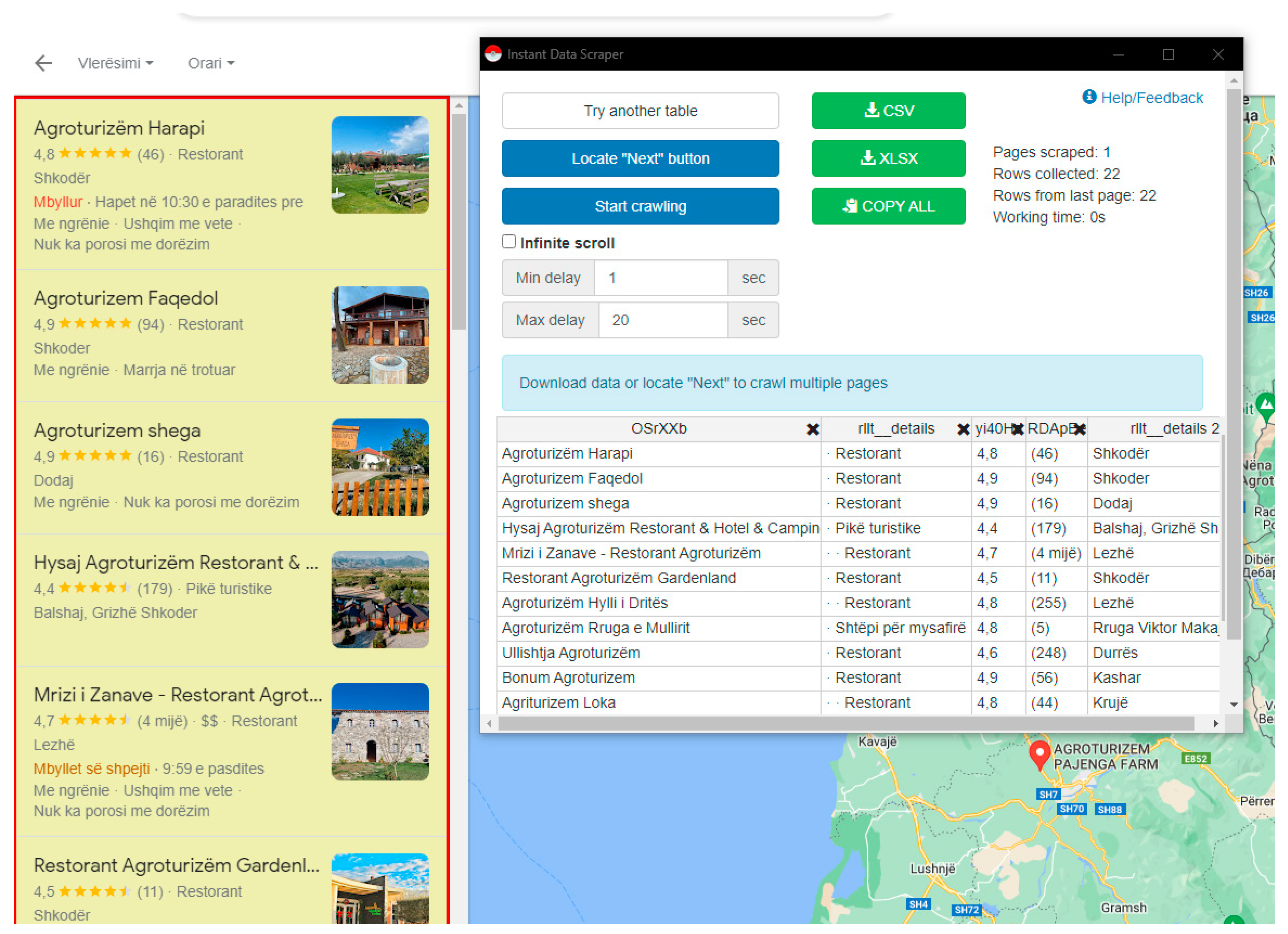
After installing instant data scraper, we are able to retrieve this data:
Figure 1.
Using data scraper.
The downloaded data:
Figure 2.
Results obtained by data scraper.
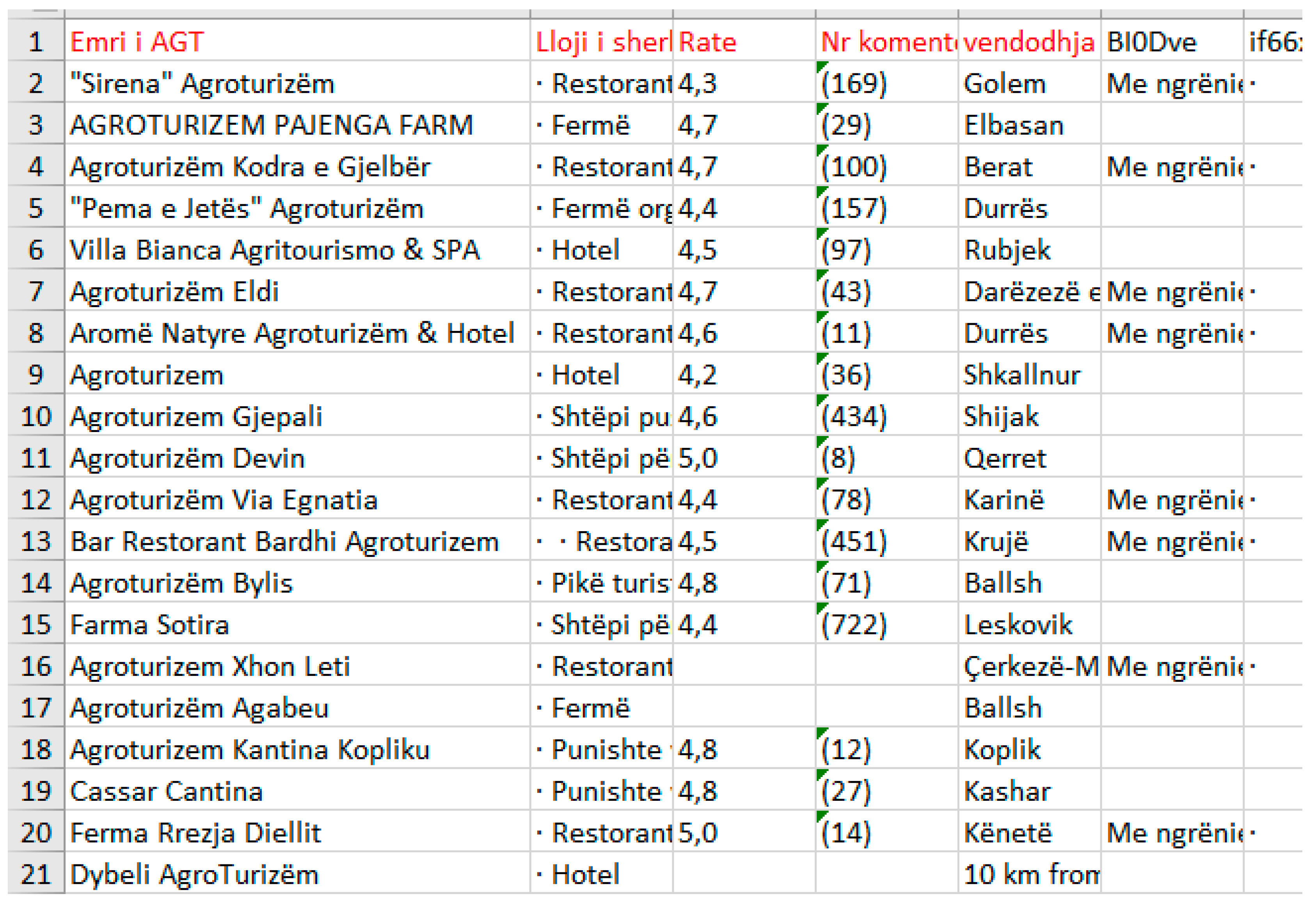
This data scraper results are then stored in our database.
- B.
- Building and using a web application to retrieve data from places Api
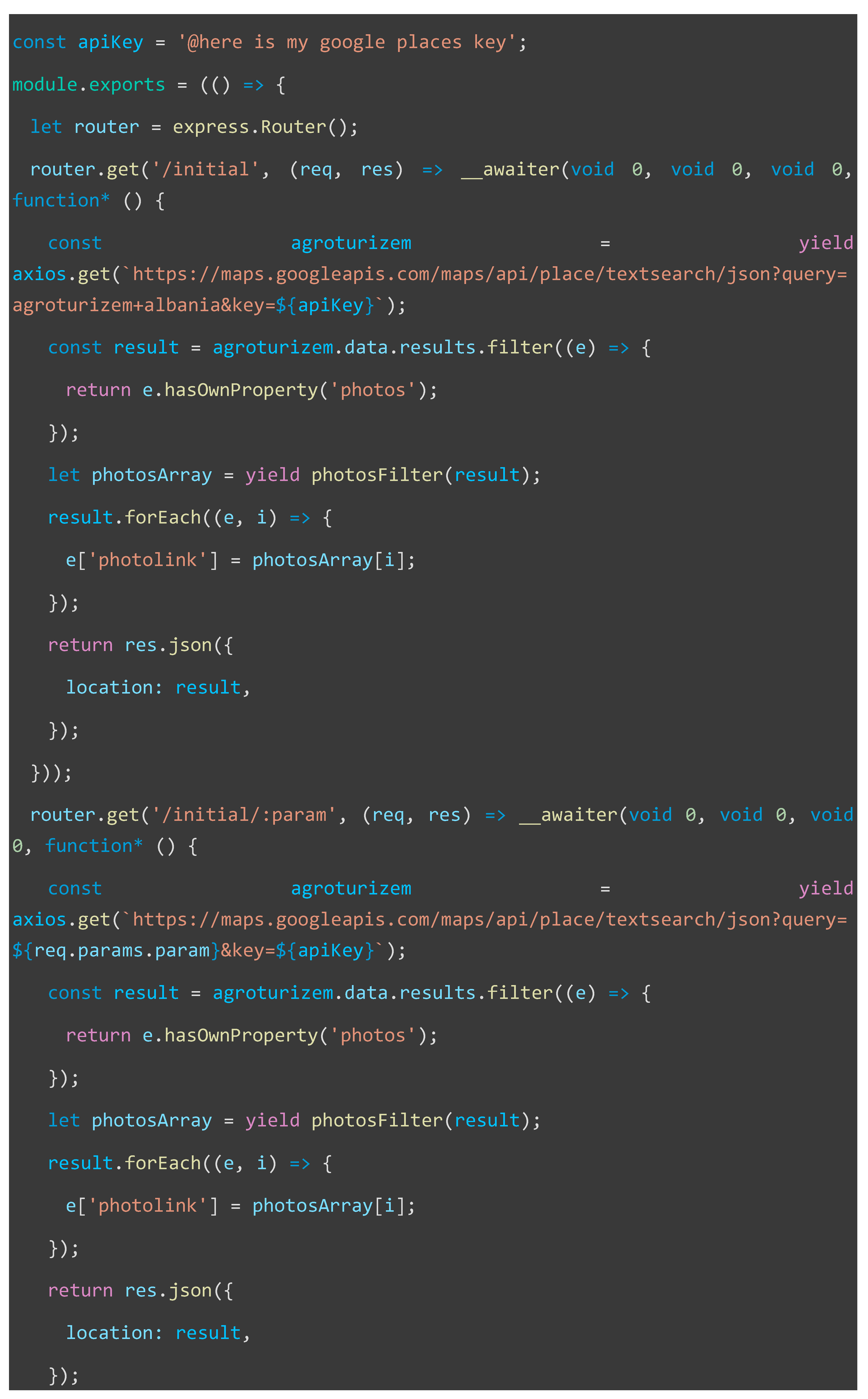
First, we will create a query to retrieve from the google places API all the id of these businesses:
const apiKey = 'OUR_GOOGLE_API_KEY';
const apiUrl = 'https://maps.googleapis.com/maps/api/place/textsearch/json';
const searchQuery = 'agritourism Albania';
const fetchAgritourismPlaces = async () => {
try {
const response = await fetch(`${apiUrl}?query=${encodeURIComponent(searchQuery)}&key=${apiKey}`);
const data = await response.json();
if (data.status === 'OK') {
const agritourismPlaces = data.results;
const placeIds = agritourismPlaces.map(place => place.place_id);
console.log('Agritourism Place IDs:', placeIds);
} else {
console.error('Error fetching data from Google Places API:', data.status);
}
} catch (error) {
console.error('Error fetching data:', error);
}
};
fetchAgritourismPlaces();
We can now retrieve all the id of the agritourism places as the following:
{
"Agroturizëm Harapi":"ChIJB_CgejwDThMRtwAeWABwRmA",
"Agroturizem Faqedol":"ChIJneZJ6C0BThMRuDn3uMOQfMI",
"Agroturizem shega":"ChIJ09QzrAAFThMRqN7EY0EAgsA",
"Mrizi i Zanave - Restorant Agroturizëm":"ChIJZ1msF5rkURMR1mv-ndiy5Sk",
"Hysaj Agroturizëm Restorant & Hotel & Camping":"ChIJTfZdxe79TRMR8xgb1KoWCgg",
"Restorant Agroturizëm Gardenland":"ChIJjaw5uzEdThMRNKGadqcU9XY",
"Agroturizëm Hylli i Dritës":"ChIJ60fCDVnkURMRDMLISKP9lWE",
"Ullishtja Agroturizëm":"ChIJ_6oztHnbTxMRmn95pUlRg40",
"Agroturizëm Rruga e Mullirit":"ChIJwbgBF-j5TRMR0PvomAO9KWM",
"Bonum Agroturizem":"ChIJM-kxR5EvUBMREXBWlzEGIO4",
"Agriturizem Loka":"ChIJLy6eSkgrUBMRPZRPhq2mhjw",
"Agroturizem Marku":"ChIJmTVQXLL_URMR0LQ-MjGBNKo",
"Nëna Dashuri Agroturizëm":"ChIJBe6KHvxzURMR7TYdN7XJt7w",
"Lahuta e Vjetër Agroturizëm":"ChIJ5WcU27rbURMRHYXqasr8vy8",
"KRONOS AGROTURIZEM":"ChIJUX3UBDcpUBMRDO0VdDTINfs",
"Alpeta Agrotourism & Winery (Alpeta Agroturizem)":"ChIJq6qquoGeWhMRELpOwVzp0nM",
"Agroturizëm Ndryshe":"ChIJ1xPI5C61URMRuITXJ1GWDik",
"Agroturizëm Lugina e Agrumeve":"ChIJe-Emjh5vWxMR1I-0O0rSv8Q",
"FAMA - Agroturizem & Argetim":"ChIJbbD4XEfbTxMR37pNRgELq3E",
"Sirena Agroturizëm":"ChIJOcRlSTzfTxMR7B-lc-XJmMI",
"AGROTURIZEM PAJENGA FARM":"ChIJf5O0_yRBUBMRlsYrQn8gS9I",
"Pema e Jetës Agroturizëm":"ChIJG_CqwFjYTxMRILpFGlq2BnA",
"Agroturizëm Kodra e Gjelbër":"ChIJQ5zIxCifWhMRsApkRMEH_3E",
"Agroturizem":"ChIJ6ZVk_v7ZTxMRj9P33DOVqO0",
"Villa Bianca Agriturismo & SPA":"ChIJf-T2CZopUBMRGa89DcgOYbs",
"Aromë Natyre Agroturizëm & Hotel":"ChIJ98arTsQrThMR81bW2qhWLjE",
"Agroturizëm Eldi":"ChIJY1Nnj0xFRRMRCzRvBzYaOHs",
"Agroturizem Gjepali":"ChIJY_GcKNPXTxMR97Z9TIXopAg",
"Agroturizëm Via Egnatia":"ChIJO_M4yYQbUBMR_mBl5L6XioQ",
"Bar Restorant Bardhi Agroturizem":"ChIJOd85eNDNURMROzCAH8Vjw-E",
"Agroturizëm Bylis":"ChIJS-LmTM63WhMRnRlCy02nW1g",
"Farma Sotira":"ChIJQVZkrEBGWhMRf11DxkBToE0",
"Agroturizem Xhon Leti":"ChIJ1x6DYxgzUBMRRohjVVBEalI",
"Agroturizëm Agabeu":"ChIJ6QKwboe7WhMRWFZuT2dJVSE",
"Agroturizëm Cantina Cassar":"ChIJYWYMnb4vUBMRkw_TMwBlaKo",
"Agroturizem Kantina Kopliku":"ChIJJxmm-Sz7TRMR_VprtaJTvLM",
"Mulliri Sali Shijaku Pikë Turistike Bujtinë Agroturizëm":"ChIJPcKkLcA5UBMR-vt1usSjOzY"}
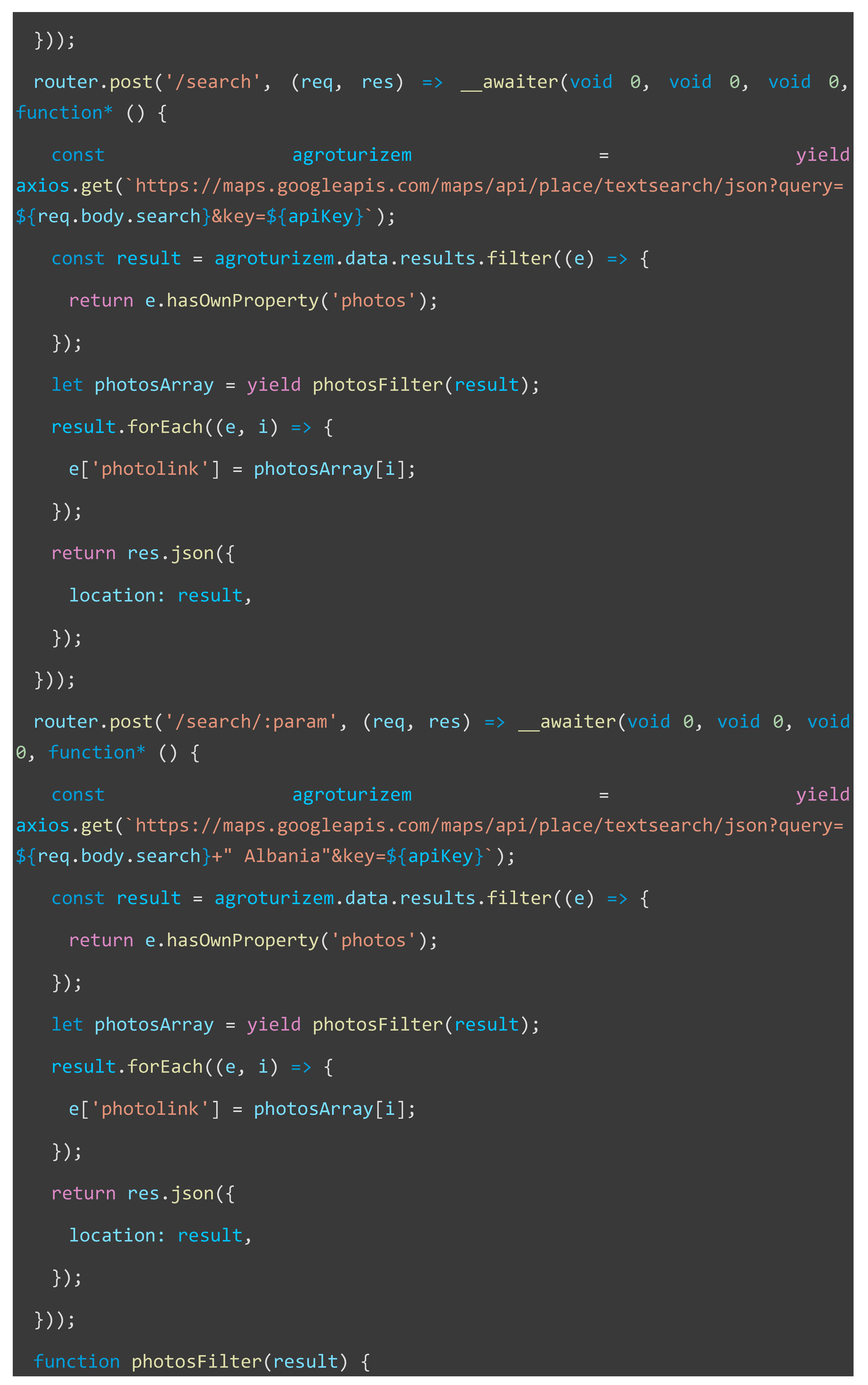
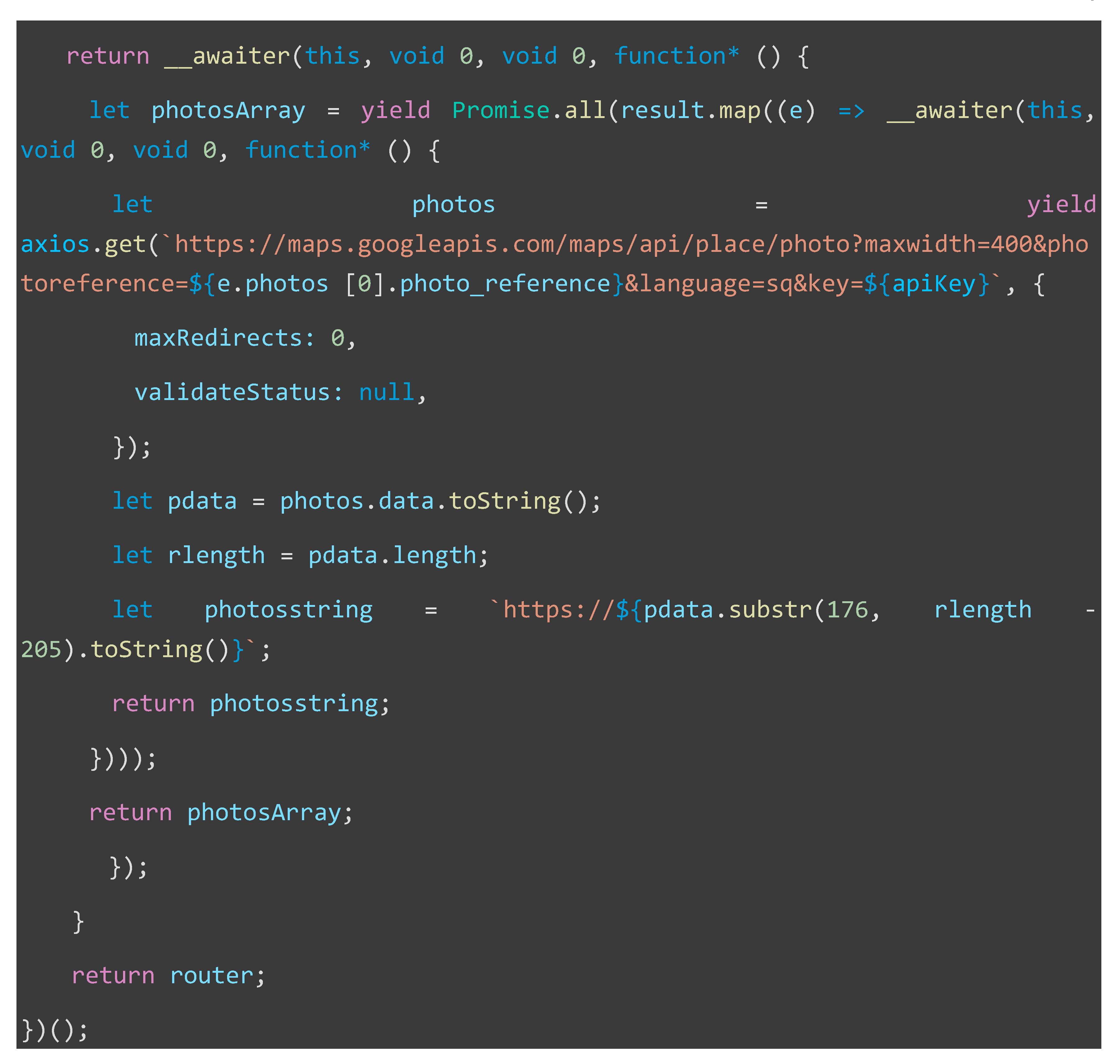
In this step we have created a web application which is able to communicate with the places Api and to extract the needed information automatically or by user search. The application sends requests to the Google Places API using the constructed queries. In response, Google sends back JSON-formatted data containing details such as the name, address, contact information, reviews, photos, websites of this places and other relevant fields for each destination. A piece of code written for this purpose is:
place_id=ChIJZ1msF5rkURMR1mv_ndiy5Sk&fields=name,formatted_address,geometry,types,rating,user_ratings_total,opening_hours,photos,website,formatted_phone_number,international_phone_number,reviews&key=OUR_API_KEY
All the JSON information is stored in a database to be than offered us for study. We take care to build some queries that avoid duplicates or missing information. Information is stored periodically and so we can check the changes and updates.
The main view of this application is:
Figure 3.
The web application we did to collect data from places Api.
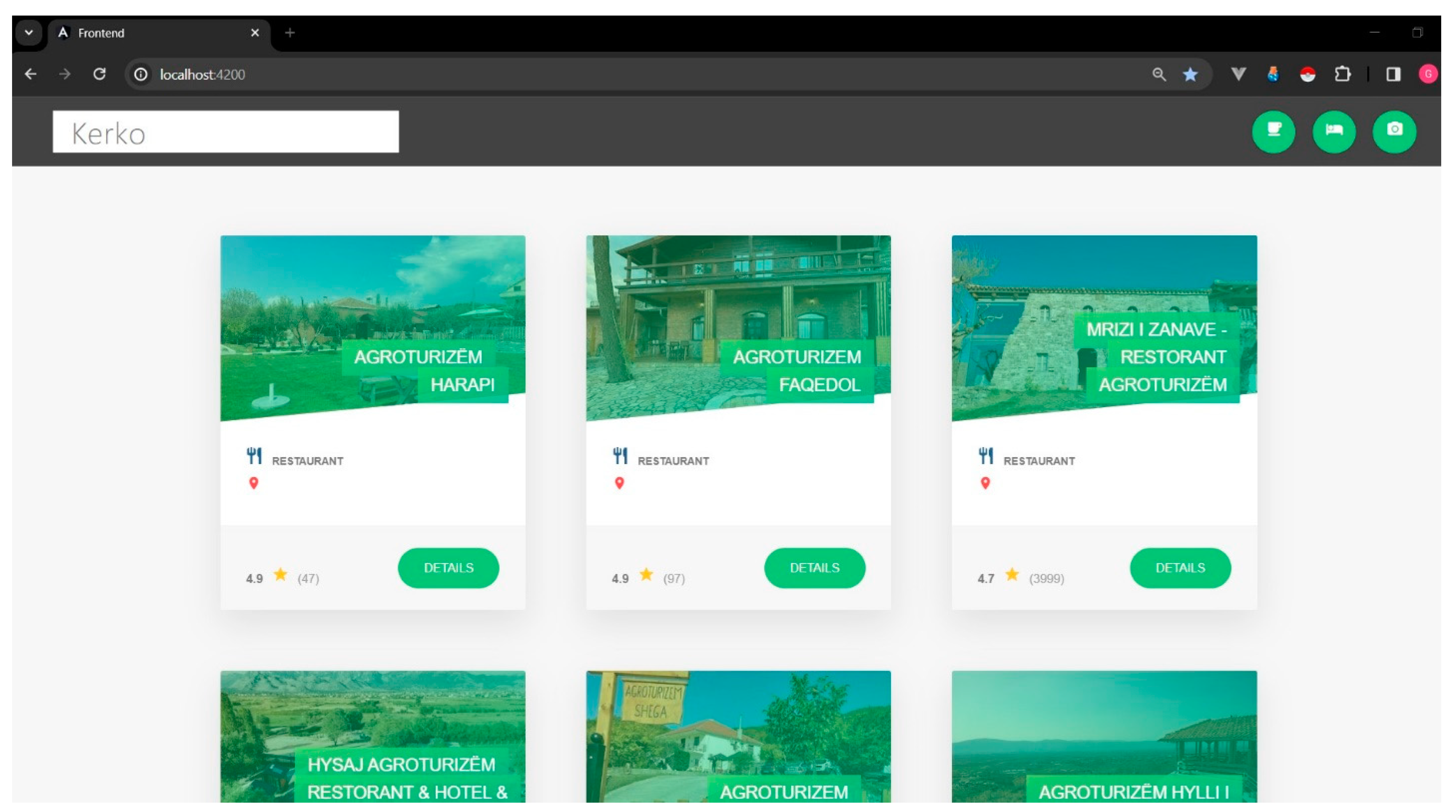
As we can see the main information is shown in the application. Some agritourism destinations are shown directly or we can continue by searching by name or by location or both. This is obtained by sending queries to google places Api by specifying the information needed and show it on the screen.
The main script written to optain the data is as following :

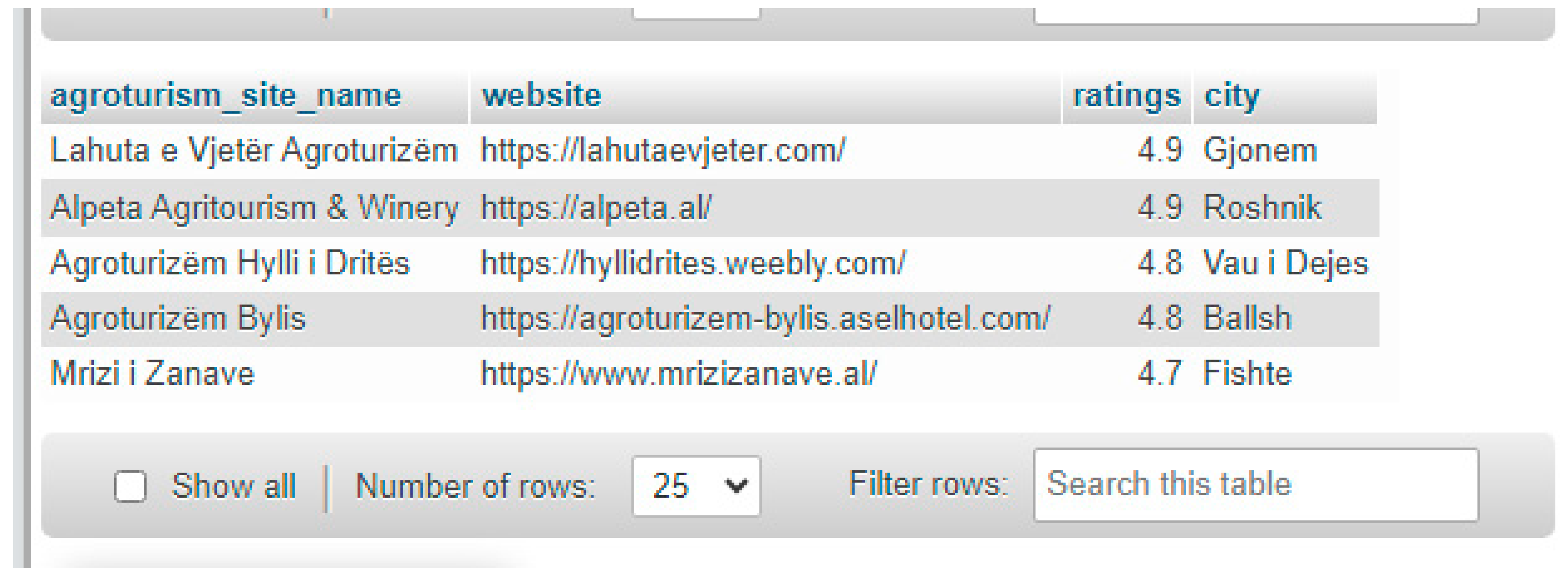
Database Result Tests
Now that we have our database populated with information, we can send queries and retrieve all the information we need. We want to find the five destinations which have their own website and the biggest rating. After the query was send, the database responds us with the results as shown below:
Figure 4.
Top 5 agritourism destinations that have their own website selected by ratings.
5. Conclusions & Recommendations
The study successfully addresses the challenge of scattered information about agritourism destinations in Albania by strategically utilizing instant data scraper and Google Maps API then collecting essential details from users. This centralization effort provides a comprehensive and easily accessible database which can be used to analyze data, make forecast, see periodically changes etc. The active use of social networks and various digital platforms by agritourism destinations demonstrates their commitment to enhancing interactivity with visitors. This approach not only fosters engagement but also showcases the adaptability of these destinations to modern communication channels. The proposal to develop algorithms and scripts for systematic collection and analysis of dispersed information is crucial. This analytical approach is essential for unveiling patterns, trends, and opportunities within the agritourism landscape, providing valuable insights for stakeholders. The centralization and streamlining of data enable potential visitors to efficiently access relevant information, such as websites, contact numbers, visitor ratings, and comments. This facilitates informed decision-making for individuals seeking agritourism experiences in Albania. The study aims to contribute significantly to the sustainable growth of agritourism in Albania. By harnessing the power of digital platforms and creating a unified database, the research sets the stage for informed policy-making, marketing strategies, and decision-making processes for the development and management of agritourism destinations.
We suggest to prioritize the implementation of algorithms and scripts for systematic data collection and analysis. This will ensure ongoing efforts to centralize and organize information, keeping the database up-to-date and relevant. Establish collaborative efforts with social networks to streamline and integrate dispersed data. This can include partnerships to directly access and aggregate information from various platforms, enhancing the comprehensiveness of the database. Ensure a regular update mechanism for the centralized database to reflect changes, new additions, and evolving trends in agritourism destinations. This will maintain the accuracy and relevance of information for both visitors and stakeholders. Develop a user-friendly interface for the centralized database, making it easy for visitors to navigate and find relevant information. This includes incorporating search functionalities and interactive maps to enhance the user experience. Actively promote the centralized database among potential visitors, stakeholders, and policymakers. This will maximize its impact on decision-making processes, policy formulation, and the overall growth of agritourism in Albania. By implementing these recommendations, the study can contribute substantially to the sustainable development of agritourism in Albania and serve as a model for leveraging digital platforms in other regions as well.
References
- Al-Naggar, R. A. , Nordin, M. S., & Sulaiman, M. (2015). Utilization of GIS for agrotourism development. Procedia - Social and Behavioral Sciences, 202.
- Buhalis, D. (2003). eTourism: Information technology for strategic tourism management. Pearson Education.
- Cai, L. , & Wang, D. (2019). Destination marketing and management in a digital world: A focus on smart tourism cities. Journal of Destination Marketing & Management, 12.
- Cai, Y. , & Wang, D. (2019). Tourism geography and GIS: A research agenda. Annals of Tourism Research, 76, 153–167.
- Getz, D. (2008). Event tourism: Definition, evolution, and research. Tourism Management, 29.
- Gursoy, D. , Chi, C. G., & Lu, L. (2012). Antecedents and outcomes of information and system quality: An empirical study of Chinese outbound travelers. Tourism Management, 33.
- Litvin, S. W. , Goldsmith, R. E., & Pan, B. (2008). Electronic word-of-mouth in hospitality and tourism management. Tourism Management, 29.
- Neuhofer, B. , Buhalis, D., & Ladkin, A. (2014). Technology as a catalyst of change: Enablers and barriers of the tourist experience and their consequences. ENTER 2014: Proceedings of the 20th International Conference on Information Technology and Travel & Tourism,.
- Crouch, D. , & Ritchie, J. B. (1999). Tourism, competitiveness, and societal prosperity. B. ( 44(3), 137–152.
- Gartner, W. C. (1993). Image formation process. Journal of Travel & Tourism Marketing, 2.
- Gössling, S. , Scott, D., & Hall, C. M. (2013). Tourism and water: Interactions and impacts. Channel View Publications.
- Hall, C. M. (2010). Crisis events in tourism: Subjects of crisis in tourism. Current Issues in Tourism, 13.
- Hall, C. M. , & Gössling, S. (2013). Tourism and water: Interactions and impacts. Bristol: Channel View Publications.
- Getz, D. (2008). Event tourism: Definition, evolution, and research. Tourism Management, 29(3), 403–428.
- Sharpley, R. (2002). Rural tourism and the challenge of tourism diversification: The case of Cyprus. Tourism Management, 23(3), 233–244.
- Xiang, Z. , & Du, Q. (2015). Review of research on tourism-related information technology. Tourism Management, 47, 78–93.
- Gursoy, D. , Chi, C. G. Q., & Lu, L. (2012). Antecedents and outcomes of consumers' online information search behavior. Journal of Travel Research, 51(4), 456–470.
- Sharpley, R. (2002). Rural tourism and the challenge of tourism diversification: The case of Cyprus. Tourism Management, 23.
- Xiang, Z. , & Du, Q. (2015). Maestro: A performance testbed for research on Chinese search engine. Journal of Information Technology & Tourism, 15.
- Wang, D. , Li, X., & Huang, D. (2019). Assessing spatiotemporal patterns of tourist attractions using geotagged photos. ISPRS International Journal of Geo-Information, 8.
Disclaimer/Publisher’s Note: The statements, opinions and data contained in all publications are solely those of the individual author(s) and contributor(s) and not of MDPI and/or the editor(s). MDPI and/or the editor(s) disclaim responsibility for any injury to people or property resulting from any ideas, methods, instructions or products referred to in the content. |
© 2024 by the authors. Licensee MDPI, Basel, Switzerland. This article is an open access article distributed under the terms and conditions of the Creative Commons Attribution (CC BY) license (http://creativecommons.org/licenses/by/4.0/).
Copyright: This open access article is published under a Creative Commons CC BY 4.0 license, which permit the free download, distribution, and reuse, provided that the author and preprint are cited in any reuse.


