1. Introduction
During the summer season, wildfires, forest fires, and agricultural fires gain worldwide media attention due to their intensifying trend. Forest destruction by wildfires burning for months in the Amazon rainforest, the Californian megafires with unforeseen destruction of urban areas, the large fires in Canada, Sweden and Russia destroying natural forests, the Mediterranean from Turkey through Greece, Italy, France, Spain and Portugal with frequent ever more dangerous fires that provoke loss of life and patrimony, are all examples of the destructive power of fire and the urgent need for humans to adapt by changing their behaviour towards fire (
https://www.newscientist.com/article-topic/forest-fires/)(Wood & Ventimiglia, 2019).
The Mediterranean climate is naturally prone to a cyclic regime of forest fires, but recent changes in aggravated fire patterns have made this a crude reality, with frequent and severe wildfires affecting these regions(Molina et al., 2019; Riera & Mogas, 2004; Wood & Ventimiglia, 2019). One explanation for this could be that humans have drifted away from nature, moving to large cities, abandoning their properties, and losing the collective memory and knowledge passed down through generations(Hobbins, 2021). In the past, the perception of risk-associated activities resulted in a limited number of ignitions and, therefore, fewer wildfires(P. M. Fernandes et al., 2016). However, in recent decades, Portugal has observed an increase in large fires, despite the decrease in the number of fire ignitions. This phenomenon is observed in the Mediterranean area and various parts of the world(Santos & Lopes, 2022).
According to many experts(Achu et al., 2021; Chuvieco & Congalton, 1989; Llorens & Fern, 2021; Modugno et al., 2016; Mokhov & Chernokulsky, 2010), the rise in large burnt areas is caused by climate change and the disturbance of forest ecosystems. This is due to the repeated occurrence of forest fires, which have been primarily observed since the second half of the twentieth century.
In Portugal, there has been a decrease in the number of fire occurrences, however, there has been an increase in the size of burned areas (Santos & Lopes, 2022),. These fires have destroyed many rural areas and have even encroached on urban and industrial areas. A notable example of this occurred in 2017, where in just two fires (June 17th and October 15th), a significant portion of central Portugal was engulfed in flames. The fires not only destroyed large areas of forest, agriculture, urban, and industrial areas, but they also claimed human lives. In total, 117 deaths were recorded in these two incidents, directly related to the fires(Catry et al., 2009; Couto et al., 2020; Parente & Pereira, 2016).
In Portugal, the start of a forest fire is mostly caused by human actions, either deliberately, to cause damage to rural landscapes, or due to negligence when using fire or machinery without due precautions on the part of the population(Catry et al., 2009; Santos & Lopes, 2022).
After the ignition of a fire, different factors contribute to the burned areas’ intensity and severity, such as relief, land use, temperature, relative humidity and wind(Modugno et al., 2016; Price & Gordon, 2016; Rodrigues et al., 2019).
Climate change has had an impact on the way rural areas are used also affecting demography where the ageing population living there is becoming more prevalent. This is due to a combination of social and economic factors, where the elderly population often lacks the financial resources and physical capacity to maintain their agricultural or forested land, which leads to uncontrolled undercover growth and the consequent buildup of fuel in rural areas(Gouveia et al., 2009; Guimarães et al., 2015; Nolè et al., 2021; Parente & Pereira, 2016).
When people in rural areas use fire during adverse weather conditions, such as when the humidity is less than 30%, temperatures are over 30°C, and winds are above 30 km/h, it increases the likelihood of a fire(Santos & Lopes, 2022; Sevinc et al., 2020). Even a small mistake can lead to a fire that can quickly spread due to the wind. It doesn’t matter what causes the fire, they all start small, and if not contained, can burn large areas with the wind playing a crucial role in this spread.
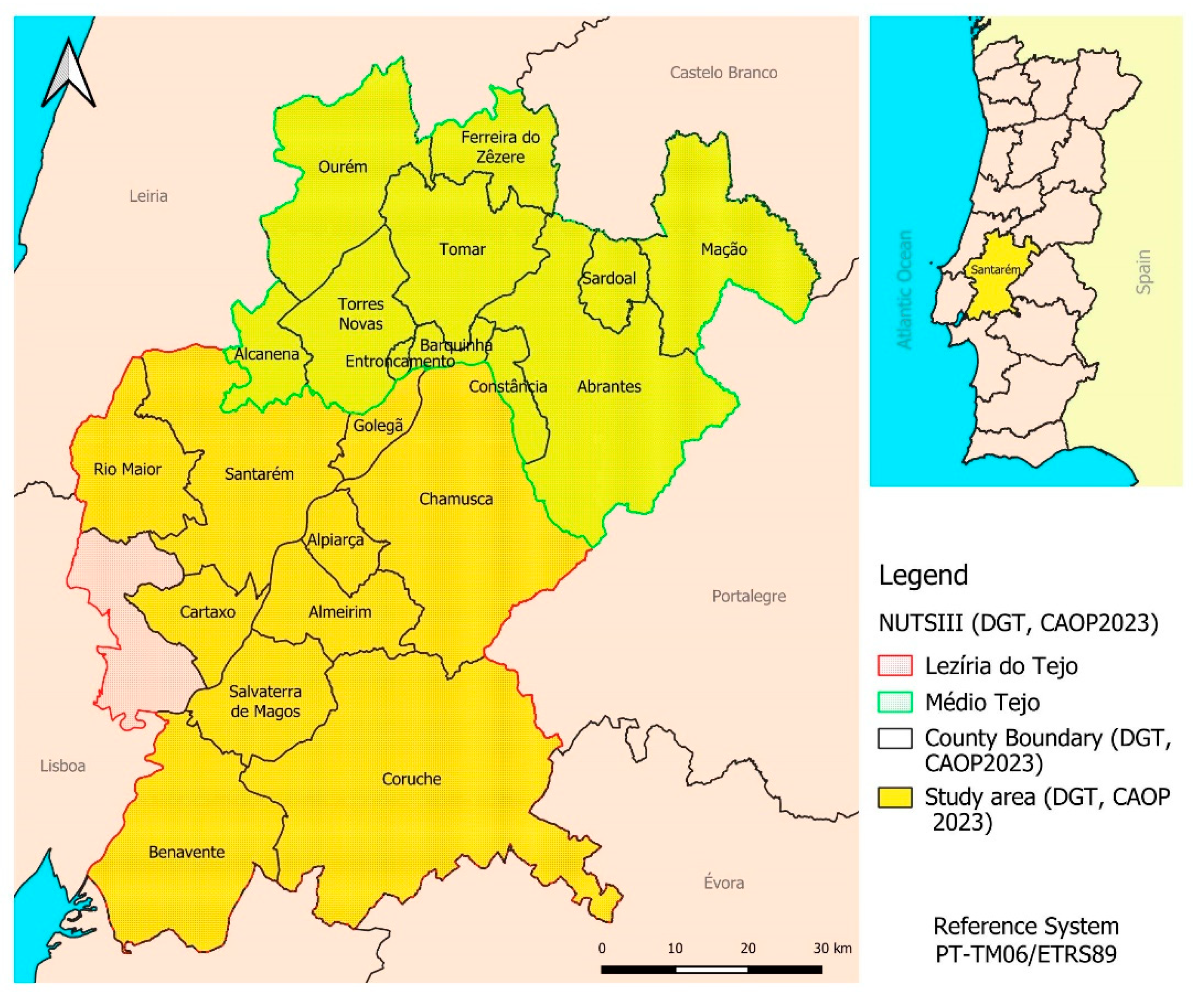
To reduce the occurrence of large fires, it is crucial to identify and comprehend the factors that contribute to human-caused fires over time and the factors aiding their spread. The purpose of this study is to examine the correlation between various causes of ignition, from negligence to intentionality and the average daily wind intensity during fire incidents in the Santarém district between 2014 and 2023.
1.1. The Main Causes of Rural Fires in Portugal
For a forest fire to happen, there needs to be a combination of fuel and oxygen present, along with an ignition source. The ignition can be caused by natural factors or human actions, intentional or unintentional due to negligence. Understanding the causes of a forest fire is essential in collecting information about its location, time, method, and reason. This information is crucial in developing policies and strategies to prevent future fires and protect the forest from potential outbreaks(Nunes et al., 2019).
It’s worth noting that prior to 1989, the investigation into the causes of forest fires in mainland Portugal relied solely on personal accounts, as there was a lack of specialized personnel in the field. This made the process rather subjective. According to J. EIRA and R. NATÁRIO (1995:79)(Eira & Natário, 1995), during the period from 1959 to 1969, 71% of the cases were investigated, with only 29% left undetermined. This was because forest fires were not yet a significant problem during that time.
Starting from the mid-1970s, the percentage of forest fires in Portugal with an unknown cause increased. This was due to an increase in both the number of fires and the burned areas, which made it difficult to determine why these fires occurred. As a result, between 1980 and 1981, the percentage of forest fires without a determined cause rose to 74%, with only 26% of fires being traced to a specific cause(S. Fernandes, 2015).
In 1989, a group of researchers led by Dr. António Carvalho, the Coordinating Inspector of the Judicial Police, and Dr. Sérgio Correia, a former technician from the General Forestry Directorate (DGF), initiated a project to investigate the causes of forest fires in Portugal. Their objective was to reduce the number of forest fires without an assigned cause and establish specialized research teams to tackle this issue. The project was carried out on an experimental basis.
In this context, during the 1989/90 season, a restricted group of forest rangers were given professional training courses, based on a methodology implemented in the United States and based on a “method of physical evidence”, which was adapted to the Portuguese reality, having been called the Evidence Method Physics of the Causes of Forest Fires (MEFCIF). From this formation, the so-called Forest Fire Investigation Brigades (BIFF’S) were formed. Briefly, we can say that this method of investigation consists, in the first phase, of locating the point of the ignition, that is, where the fire started. To this end, the indicators related to the typical behavioural patterns of fire are evaluated, more specifically, the observation of the marks left on the plant fuels by the passage of the fire, as well as other characteristics, namely the relief, the meteorological conditions and the vegetable fuels, which will allow us to understand the direction of the progression and, in this way, to locate the starting point(P. M. Fernandes et al., 2016; S. Fernandes, 2015).
After making a determination, the entire site is investigated by a team whose purpose is to collect both physical evidence (surrounding environment and deflagration conditions) and human evidence (testimony of persons). They use a specific form to gather the data, which can then be cross-referenced to fit into one of the categories present in the classification of causes (P. M. Fernandes et al., 2016; S. Fernandes, 2015). The success of this investigation is usually inversely proportional to the time elapsed between the outbreak and the knowledge of the facts and the beginning of the site inspection, as there is a risk that material evidence may be destroyed.
In the summer of 1990, when these brigades were still in their experimental phase, they were directed to regions with a high number of forest fires and, as a result of their good performance, there was then an increase in the number of BIFF, especially in the 1992/93 season, as the courses were extended to a wider group of operatives. This allowed brigades to be distributed throughout the continental territory, remaining in activity until 1997, when they were dismantled, and this technical skill was developed by the National Forest Guard Corps (CNGF), also known as the Forest Police, created in 1997 and later extinguished in 2006.
From 2006 onwards, the investigation of the causes of Fire Ignitions (Fis) was carried out by the Forest Protection Teams (EPF’S), of the Nature and Environment Protection Service (SEPNA), belonging to the National Republican Guard, as a criminal police body in the forest area, composed of former members of the CNGF who were transferred to these teams, due to the extinction of the CNGF. determined by Decree-Law which divided the causes of forest fires into two groups: natural fires and anthropogenic fires.
Over time, man has learned to master fire, which originated from natural causes that shaped ecosystems, such as lightning, and volcanic eruptions, among other causes.
With the more frequent use of fire by man, it has been necessary to classify the different causes by taking into account their origin and motivation.
In Portugal, the causes of forest fires are classified according to a hierarchy that is divided into categories, groups and subgroups and is represented by digits. Each level is assigned a digit, resulting in the most detailed determination of the cause of a forest fire in a three-digit number.
Currently, according to the system implemented in Portugal, there are six categories of causes of forest fires, which are: use of fire, accidental, structural, incendiarism, natural and indeterminate. Some of the categories are divided into groups that identify the activities that cause forest fires to be ignited, and the groups are subdivided. This represents the attitudes and behaviours that gave rise to the fires and corresponds to the highest level of particularity of the causes of forest fires.
The main groups to which the causes of forest fires correspond in the category of “fire use” are, waste burning, biomass burning, fireworks launching, bonfires, smoking, beekeeping and chimneys, which are grouped taking into account the attitudes that trigger the ignitions of fires, all of which correspond to negligence in the use of fire and that when related to geomorphological conditions, land occupation and climatic conditions can cause large burning areas.
The category of accidents is divided into the groups of transport and communications, machinery and equipment and other less common accidental causes, and this category belongs to negligent acts since the start of the fire since the proper precautions have not been taken directly or indirectly to prevent the start of the fire.
In terms of the structural category, this is divided into the group of hunting and wildlife, land use, activities related to forest firefighting and other structural causes.
The category of incendiarisms has two major groups, which are the intentional ones that correspond to the behaviour that man has in the use of fire with the objective of causing damage in rural areas and that is considered an intentional act, while the other group that corresponds to the unimputable ones belongs to negligent acts because the people who use fire do not have the consciousness or cognitive capacity to understand that the use of fire can cause danger to them or others.
Fires in which the outbreak occurs after an atmospheric electrical discharge on the vegetation existing in the rural area corresponds to the category of natural fires that only have one group, which corresponds to lightning.
Finally, there is the category of indeterminate, which corresponds to fires in which the investigated, after carrying out all the steps to identify the origin of the ignition, are unable to gather all the material and testimonial evidence that supports the true origin of the fire. This category only has a group that is subdivided into indeterminacy of material evidence (code 610), indeterminacy of personal evidence (code 620) and indeterminacy due to gaps in information (code 630), these causes are only assigned after all previous hypotheses have been exhausted.
One of the causes that is also of concern is the re-ignition (code 711) which corresponds to a new occurrence that begins in the perimeter of the area affected by a fire already considered extinguished and where they are not operational, and their origin begins in a heat source of the previous fire, the most common situation corresponds to roots that remain in combustion.
1.2. Wind
The complexity of local wind conditions cannot be explained without looking into the fundamental characteristics of global wind circulation motivated by the work of Hadley in 1735 who realised that solar heating on the globe occurs differentially, resulting from the spherical geometry of the planet. This process results in the production of warm air masses in the low latitudes – in which there is a radiative surplus – and the production of cold air masses in the high latitudes – in which there is a radiative deficit. The temperature difference between those air masses implies differences in density, with tropical air being less dense than polar air. Due to gravitational force, tropical air will tend to move towards the poles and upwards, while polar air will tend to move towards the equator and downwards, also playing an important thermostatic role. In this way, Hadley proposed a single–cell or Hadley-cell circulation model, with hot air rising and air descending. Later, Ferrel (1856) complemented the complexity of the circulation model, encompassing the effects of globe rotation, redistributing energy and proposing three cells instead of one, justifying the existence of the intertropical convergence zone (ITCZ), and two additional characteristics of the global circulation: the existence of two zones of very intense wind from the west, at altitude – the Jet Streams – and the existence of a zone of strong temperature gradient in the middle latitudes – the Polar front(Trigo et al., 2016).
Although Ferrel’s model contributes to the observed global circulation limits are far from symmetric creating isolines controlled by orography and roughness on the globe’s surface. In the case of average temperature distribution, a strong planetary North-South gradient is observed with a maximum equatorial zone and a polar minimum. Circulation also varies seasonally between continental and oceanic regions, for example in winter, temperature minimums are observed in the interior of Asia (Siberia) and North America (Canada), associated with cold anticyclones, while the air temperature is relatively high, at the same latitude over the Atlantic Ocean, due to the presence of the Gulf Stream. In summer, the opposite situation is observed, with continental warming, associated with thermal depressions, and lower temperatures in the maritime area, especially along the west coast of the continents. This annual cycle is enhanced in the Northern Hemisphere, due to large continental regions (Gouveia et al., 2009; Robson et al., 2013).
Focusing on the Iberian Peninsula, the pressure distribution at the surface shows important differences between continental and oceanic zones, creating patterns, over the North Atlantic, the Azores anticyclone located around 30ºN in January, extends towards the British Isles in July, condition the climate in Portugal and Spain. Because on continents, the distribution of pressure is completely different the air that converges at the surface over a depression is withdrawn to the upper layers and there diverges in altitude, and the reverse mechanism is expected to occur in anticyclones, this creates wind patterns and affects surface temperature in combination with the effects of friction. In some regions, however, the properties of the surface vary so abruptly that they can give rise to an organized circulation that can affect the local climate. These circulations, produced in response to the existence of temperature differences between nearby surfaces, are generically referred to as breezes, both land and sea(Gouveia et al., 2009; Russo et al., 2017; Trigo et al., 2016).
When breeze circulations dominate atmospheric runoff over a large region, they can give rise to the formation of hot depressions over the continental areas known as thermal depressions such as the one forming over the Iberian Peninsula during the summer. The prevalence of this circulation regime in the Iberian Peninsula is due to the geometry of the peninsula. The warming of the continent during a summer day initiates the circulation of the sea breeze. As the altitude of the ground increases inwards, the circulation breeze is enhanced by a valley breeze.
As the system is maintained over many hours, the effect of the Coriolis force deflects the breeze to the right, creating an almost perpendicular circulation to the coast in a practically parallel circulation. The result is a closed circulation in the peninsula’s centre, rotating in a cyclonic direction - counterclockwise(Trigo et al., 2016).
The circulation of the thermal depression in the Iberian Peninsula gives rise to a northerly wind or Northwest across the west coast of Galiza and Portugal, with increasing intensity throughout the day, reaching a maximum in the late afternoon, these winds are known as the “Nortada” regime, characteristic of Portuguese summers. During the night, the northerly wave loses intensity, but there is usually no reversal circulation, meaning no significant land breeze is observed. In fact, during the summer, the temperature in the interior of the Peninsula is low during the night, but it almost always remains just above the surface temperature of the Atlantic, which is relatively low in the vicinity of the Peninsula, due to the cool southwards’ oceanic currents.
3. Results and Discussion
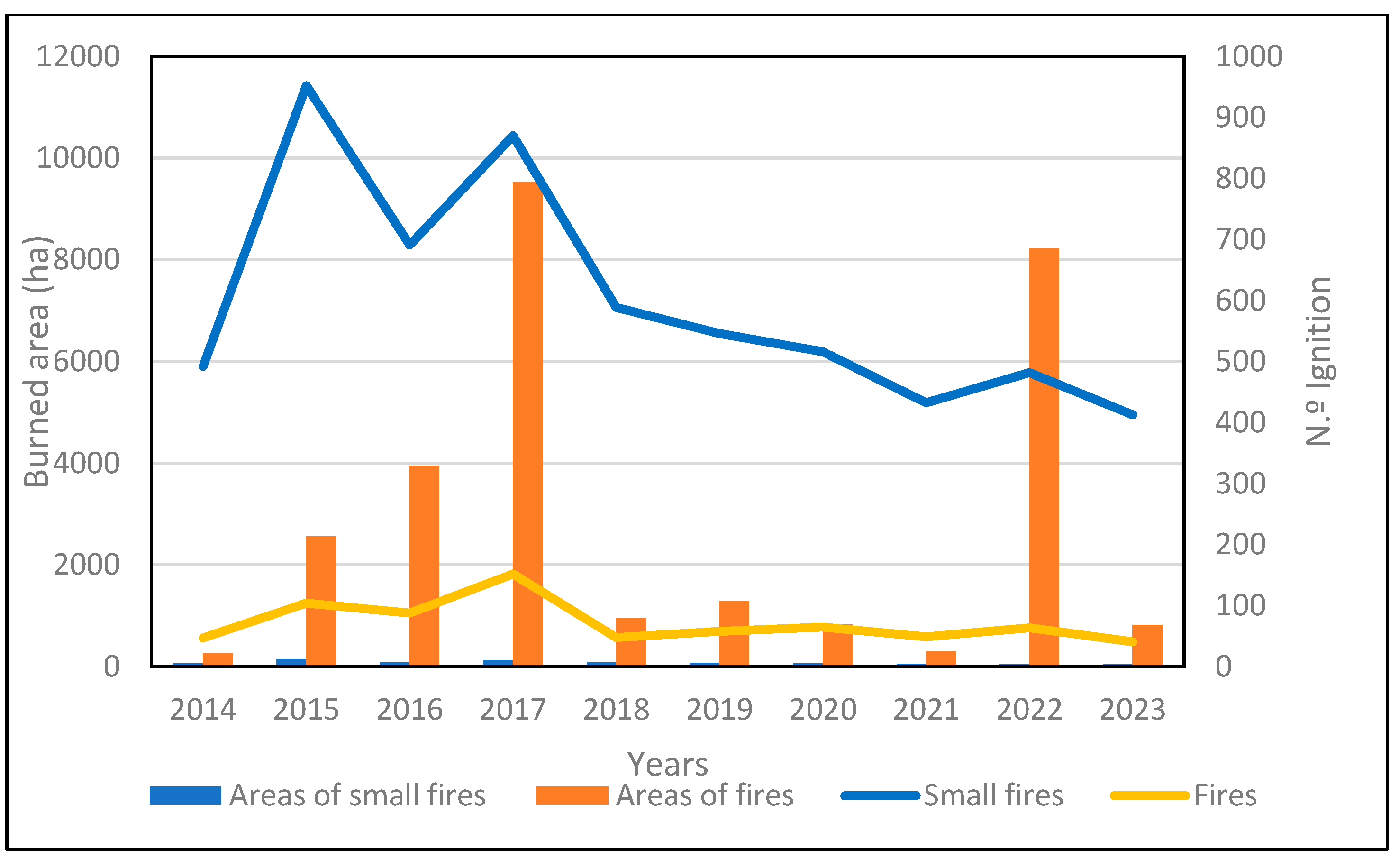
The analysis of forest fire occurrences in the period under study considered the division in large and small fires where small were all below 1ha and large all above.
Figure 2 resumes and allows us to to understand not only the number of occurrences distribution and the area burned over the years but also the motives that originated the beginning of small and large fires.
In terms of the annual evolution of occurrences over the period considered between 2014 and 2023, (
Figure 2) there was an average number of 670 forest fires per year. The years 2015 and 2017 exhibited above-average occurrences, with 2018 almost reaging this treshold. After 2017 there is a decrease tendency to the number of occurrences. In terms of the annual burned areas in the study period 2014 to 2023 it is possible to observe that, as expected, the burned area resulting from small fires is not very significant, whereas large fires can consume over 2000ha as observed for the years 2015, 2016, 2017 and 2022 as per literature(P. M. Fernandes et al., 2016; Modugno et al., 2016).
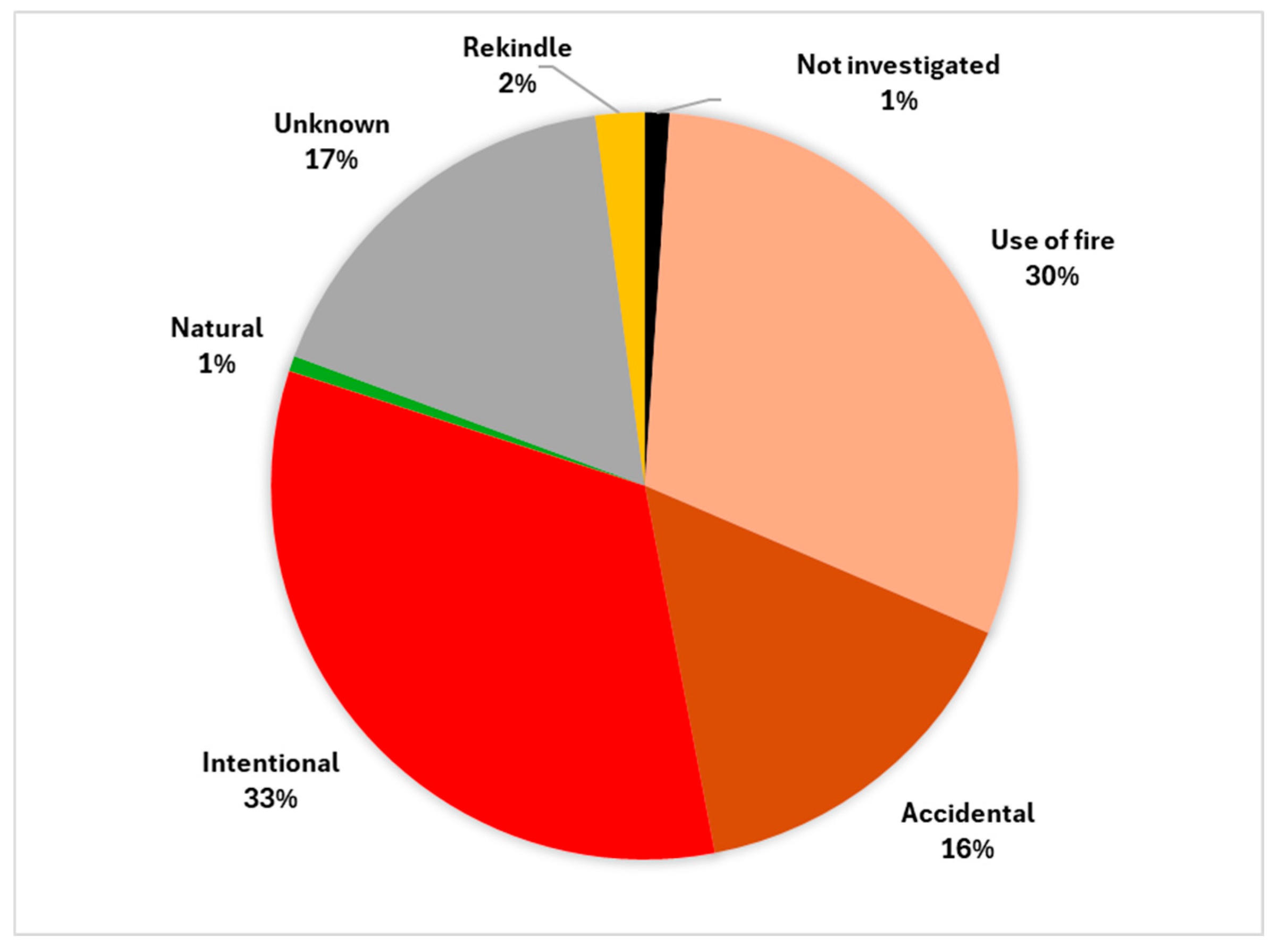
Fires were categorized into different causes including “Not investigated,” “unknown,” “natural,” “accidental,” “use of fire,” “intentional,” and “rekindle,” based on the ICNF categories. The results depicted in
Figure 3 show that only 1% of the fire occurrences were not investigated. This is a testimony to the dedication of the forest fire investigation teams from the National Republican Guard in the Santarém district, who are committed to identifying the causes and motivations that led to the fires.
Figure 3 illustrates the identified fire causes for the study period.
Fire ignitions are mostly associated with negligent causes on the part of the population, for this study, despite the 7 categories, one could divide causes into 3 major categories, the Negligent, considering the “use of fire” (30%), the “accidental” (16%), and the ”undetermined”, despite the latter being rather a grey area, though together they correspond to over half of the occurrences. The Criminal fires considering the“intentional” fires that correspond to those caused by humans intending to cause damage to rural landscapes represent 33%. Finally, the Natural causes are represented by the “natural” category with only 1% as these events are rare and normally associated with dry storms and lightning (
Figure 3).
As natural fire causes are rare we are left with two large categories, “use of fire,” and “accidental,” which can be associated to Carelessness causes, together represent 46% of the ignitions if the “unknown” causes 17% are neglected. The Criminal category of fires is referred to as “Intentional” fires, or criminal fires, and accounts for 33% of all fires. Legally, this division exists as a way to determine the severity of punishment, with harsher charges applied to criminals who intentionally use fire. Charges for accidental fires involving fire will be harsher than those not involving fire.
Data presented in
Table 1, shows the occurrence of fires per category for each year between 2014 and 2023, with the number of fire incidents in each category varying from year to year. This is normal as some years may have milder summers and therefore fewer fires. However, the numbers are still significantly high, especially until 2017 and in the “use of fire” category, associated with slash and burn and biomass burning activities both in forestry and agriculture.
The year 2017 represents a tipping point, particularly because of the catastrophic magnitude of the events. The aftershock raised awareness both to the general public and the government, resulting in the Decreed legislation making it mandatory to clean properties particularly those near and in the vicinity of habitational areas, and the communication to the legal authorities of all the fire use activities, implemented in 2019.
Surely the tragic events that took place in Portugal in 2017 led to a change in population behaviour and awareness. This change was brought about not only by the introduction of new legislation rules that required reporting of any use of fire in any activity but the shock that the tragic events caused on people’s attitude towards keeping their property clean. Interestingly, in 2018, there was a significant decrease in the occurrence of all categories, except for the increase in the number of occurrences for the category “use of fire”. This behaviour is a perfect example of how communities react to tragic events by mobilizing efforts to mend things. These efforts could work towards reducing ignitions. If there were not an aged population with an overly zealous attitude, a lack of organization, and an enormous accumulation of biomass due to abandonment, the risk of ignitions would be much lower.
The remaining 2018 categories all decreased just after the tragic event, a decrease in “accidental” occurrences can be attributed to people becoming more aware and responsible, also observed in the “rekindle” as firefighting forces were more alert. The decrease in “intentional” is year after year associated with wide media coverage, which can influence both positively and negatively. Most criminal actions commonly are attributed to mental diseases and harm to property, not to human life harm. 2018 was a clear example that alarm can have tragic results if regulated, therefore agricultural or fires, slash and burn activities and biomass burning, require clear regulation and an increase in awareness-raising actions among the population associated with a reinforcement of surveillance in rural areas.
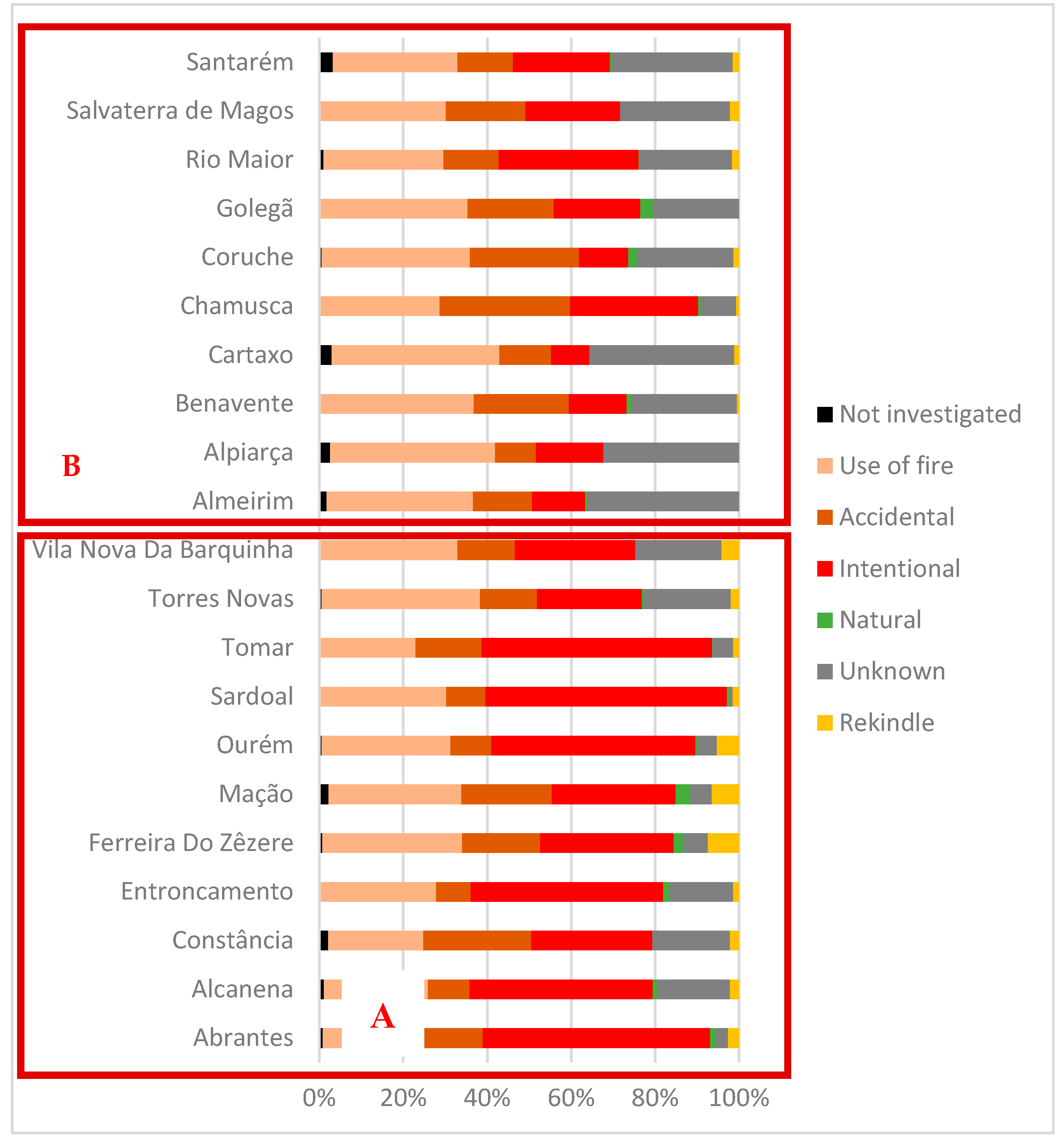
When analysing fire causes, besides the environmental and climatic, another set of important variables is a geographic location associated with land use and population,
Figure 4 displays the percentage of occurrences by category, sub-region and municipality.
The “Leziria do Tejo” sub-region is characterized by the Tagus River fertile floodplain used primarily for agriculture with a few forested areas, whereas the “Médio Tejo” sub-region is a transition area with a mix of vegetation moving from agriculture in the lowlands to forestry patches and bush towards the rocky karstic mountainous areas which border the region to the north.
Despite land use differences between the sub-regions it is possible to observe that the incidence of intentional fires is higher in the “Médio Tejo” when compared with the “Lezíria do Tejo” in all municipalities. Furthermore, the municipalities that exhibit higher levels of forestry in the Leziria do Tejo Sub-region, such as Chamusca and Rio Maior, hold a higher number of intentional fires. The somehow related Intentional fires in forests may be attributed to the abandonment and consequent land disputes, regulations restricting urbanization, or pyromania. The Leziria do Tejo Sub-region holds a higher incidence of accidental and unknown causes mostly due to the agricultural need to use machinery, biomass burning as a traditional method of land clearing that is widely used by farmers to prepare cultivated fields for subsequent crops, and slashing and burning of biomass in open fields is also a common agricultural practice used by smallholder farmers to clear cropland and convert land use.
After a general analysis of the major causes of fire, a more particular approach was chosen, taking into account the reasons that originated the occurrences, and what the relationship was with the average daily intensity of the wind, and for this purpose, only the causes belonging to the categories “use of fire” and the “accidental”, giving greater emphasis to the causes in which the percentage of occurrences are higher, and no human intention to use the wind in their favour occurred, which may be the case of “intentional” category.
The causes that originated the most forest fires in the category of “fire use” were the burning of agricultural leftovers and cut and piled bushes (11%), followed by the clearing of agricultural soil (4%), which corresponds to the burning of vegetation without being cut, the clearing of forest soil represents (3%) and corresponds to the use of fire to eliminate leftover vegetation that is found in forest areas.
In the “accidental” category, the most representative cause is electrical lines (6%) which corresponds to fires that were caused by contact, discharge, breakage or electric air of electric power transmission lines, ignitions caused by the friction of the metal parts of agricultural implements with stones correspond to (2%), while with 1% there is the emission of incandescent particles, sparks or conduction heat transmission from agricultural machinery or other sources.
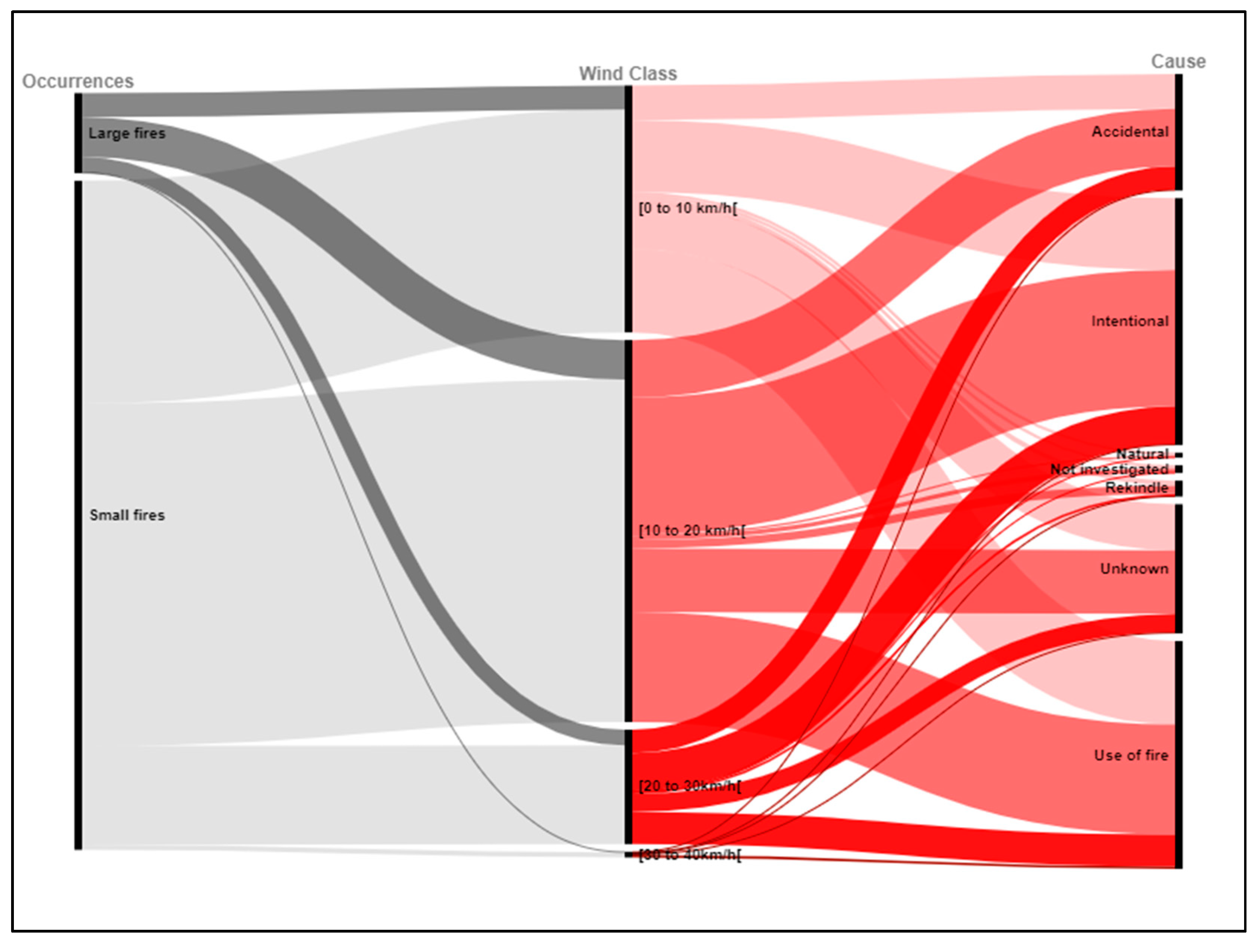
Wind plays a major role in how the ignition source originates a fire,
Figure 5 shows the relationship between occurrences, the wind intensity measured in classes and the causes of fire. As seen before most ignitions originate only small fires, hence the representativity when compared to large fires. Regarding the wind classes most fires, both large and small, occur on the [0 to 10km/h[ and [10 to 20 km/h[classes, with much fewer fires occurring in the higher wind classes. This may be explained by the collective memory knowledge of the population and after 2019 the legislation.
When analyzing the fire ignitions with the average daily wind intensity at the site of the occurrence, it was observed that more than half of them occur on days with wind in the middle of [10 to 20 Km/h[ class(
Figure 4), whereas with intensities greater than 30 Km/h we observe only 1% of the total occurrences under study, and of this 22% occurred due to the use of fire in the burning of agricultural leftovers and cut and piled bushes. This demonstrates the disregard for potentially dangerous situations on the part of the population in the use of fire on very windy days.
Overall
Figure 5 brings to evidence the importance of the the wind class [10 to 20 km/h[ in the fire ignition scenario for this region. The problem may be associated with bad judgement from the side of the population, probably deriving from the lack of collective memory and the daily wind conditions variability. As mentioned before late afternoon “nortada” winds intensify wind class generating wind gusts of over 30 km/h, so where conditions were adequate for some practices, suddenly they are not any more, and people will facilitate giving origin to serious accidents. Another issue is that after 2019 the government and local authorities will release daily the risk levels, this creates a problem as some people will feel legitimised regardless of the particular conditions in the place they are performing their activity. Education needs to play a major role in creating awareness of what conditions are acceptable for a certain activity and what safety measures to apply should conditions suddenly change.
