1. Introduction
The conservation and restoration of existing infrastructure are increasingly crucial, particularly for structures possessing historical heritage value. This urgency arises from factors such as their age and the escalating threat of external elements, notably the more frequent occurrences of flooding due to climate change. A comprehensive study of this type of infrastructure should encompass a holistic perspective, addressing aspects ranging from urban and architectural considerations to historical, social, and economic dimensions [
1].
Given the intricate nature of urban realities in Latin America [
2], this study proposes an evaluation methodology from a hydrological standpoint. The objective is to contribute to the knowledge base concerning the conservation of heritage bridges situated in riverbeds. This approach is intended to better equip the entities responsible for managing such infrastructure. The proposed methodology will be validated through its application to the case study of the Grau Bridge in the city of Arequipa, Peru.
The city of Arequipa boasts several historical monuments accorded the distinction of "World Heritage of Humanity" by the United Nations Educational, Scientific and Cultural Organization [UNESCO] in 2000. These monuments predominantly comprise colonial constructions, including mansions, cathedrals, churches, and bridges [
3]. Additionally, a noteworthy feature is the prevalent use of “sillar”, a volcanic material of the white ignimbrite variety, similar to ashlar, enhancing the architectural splendor of the city, often referred to as the White City.
Arequipa, the second most populated city in Peru, is home to over 1.3 million inhabitants [
4] and is prone to significant earthquakes due to its location within the Pacific Ring of Fire, resting on the tectonic plates. Consequently, historical monuments in the city require continuous monitoring for seismic threats. The region experienced the impact of a powerful earthquake on June 23, 2001, in the coastal zone of southern Peru [
5], revealing the vulnerability of structures, such as the Grau Bridge and a significant portion of the historic city center, both constructed with volcanic rock masonry walls filled with sand and lime mortar in a parallelepiped form. This earthquake showcased the fragile behavior and crack propagation along the base of these structures. Furthermore, lateral load tests have indicated that the Grau Bridge is susceptible to bending cracks in the lower zone of the central pillars during severe earthquakes [
6].
While seismic risks are crucial to consider, this research emphasizes hydrological risks, as bridges in Peru have demonstrated susceptibility to such phenomena as floods. It is noteworthy that flood-related incidents are a major contributor to bridge failures in river channels, causing flooding and scour in abutments and piers [
7]. For instance, the El Niño Phenomenon between 2016 and 2017 resulted in the destruction of 449 bridges nationwide [
8], underscoring the lack of resilience in Peru to extreme events [
9]. Additionally, the design of bridges in riverbeds often neglects the impact of climate change [
10].
The Grau Bridge, along with other structures spanning the Chili River, exhibits signs of insufficient maintenance, thereby jeopardizing the safety of users [
11]. Consequently, a thorough investigation into its vulnerability is imperative to mitigate associated risks, enabling necessary interventions to extend its operational lifespan while preserving its heritage significance [
12,
13]. Among the various risks, flood risk is particularly critical and depends, in part, on the positioning of infrastructure such as houses along the banks of natural channels. Adjacent bridges, like the Bajo Grau Bridge located 100 meters downstream from the Grau Bridge, have been closed due to non-compliance with the recommendations of the Extraordinary Maximum Water Level (E.M.L.L.) per Peruvian standards, with studies indicating their high vulnerability [
14,
15,
16]. Therefore, a comprehensive evaluation of these bridges is essential to ensure optimal service levels and structural integrity [
17].
Recent studies propose evaluation methods for riverine bridges incorporating multidimensional approaches with parameters such as structural material, proximity to population centers, and the potential for flooding. While 1D hydraulic models in HECRAS are commonly employed in such assessments [
16,
17], there exists a knowledge gap regarding the hydrological evaluation of heritage bridges in river channels, particularly those utilizing more representative models, such as 2D models. This research aims to address such gap through a comprehensive analysis of the Grau Bridge, incorporating a 2D hydraulic model in HEC-RAS. The methodology involves an exhaustive literature review, a historical examination of the bridge, a preliminary hydrological diagnosis, and subsequent hydrological and hydraulic studies under various scenarios. Furthermore, a multi-criteria vulnerability analysis, informed by the literature review, is conducted, culminating in strategic recommendations for the conservation of the bridge. The proposed methodology is designed for adaptability and replication in studies of heritage bridges with similar characteristics.
2. Materials and Methods
2.1. Historical Review
Until the end of the 19th century, Arequipa was clearly divided into two sectors. A central area where the main commercial activities took place and where important infrastructure such as the town hall and the hospital were located. An area subdivided in two, the right and left banks of the Chili River, where the rural workers' populations were located [
18]. Given the urban and commercial development, it was necessary to establish a communication route between the two banks, a new bridge in contrast to a provisional.
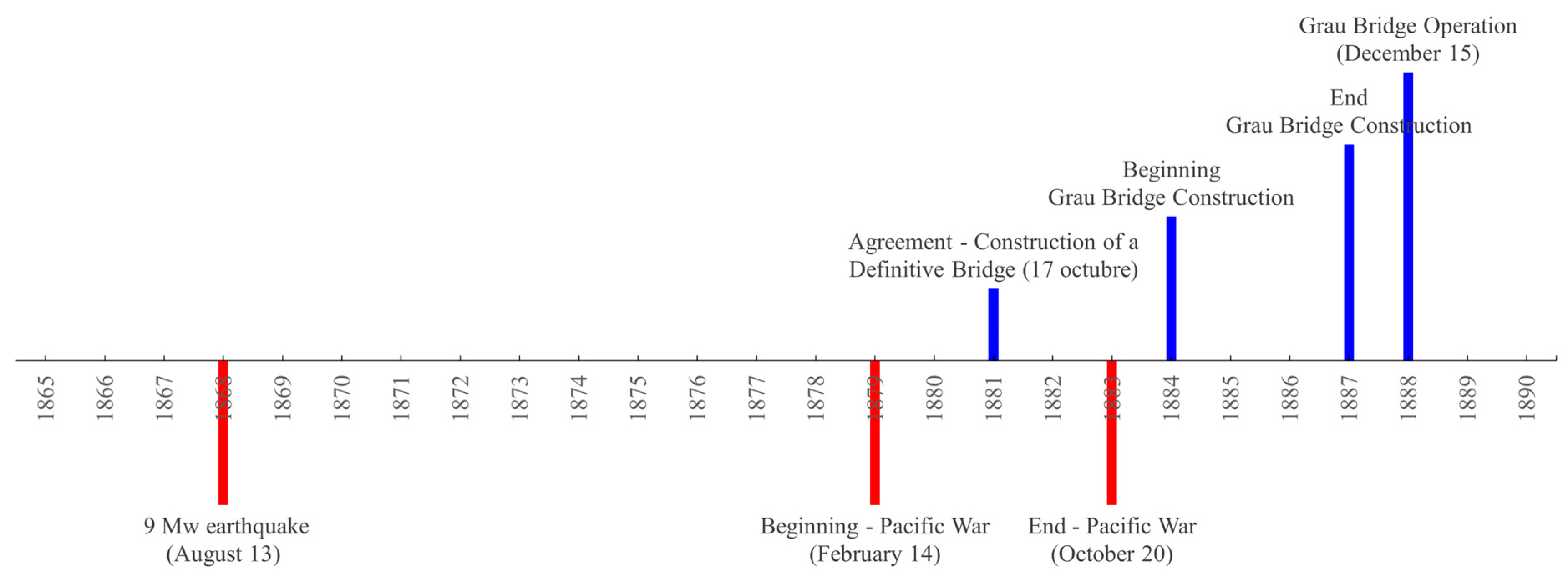
In 1868, the work had to be done, because it had the funds, materials and the decree by the president of the republic Pedro Diez Canseco. The “quintas”, small residences, called Vargas and Sánchez on both sides of the Chili River were purchased, but the work was paralyzed, and the work was totally lost due to the earthquake of approximately magnitude 9 on the Richter scale in Peru and Chile [
18].
In 1881, an attempt was made to build the bridge, which was to be made of stone and iron, three meters wide and four meters high above the water level of the river, but the ravages of the War of the Pacific (1879 - 1883) and the occupation of the capital by Chilean troops, postponed the work until 1883. That same year it was also agreed that the construction of the new bridge would be modified to 40 meters long by eight meters wide, with a height corresponding to the level of the embankment that exists today and on two abutments and two stone and ashlar pillars, similar to the structure of the Puente de Fierro (1870). On October 17, 1881, the Municipality of Arequipa agreed to the construction of a definitive bridge made of stone and ashlar and entrusted the work to the Italian architect Juan Albertazzo for its construction during the last decades of the 19th century. However, the disastrous War of the Pacific prevented the Municipality from having the necessary funds for its construction until 1884, when the architects Juan Rodríguez and Manuel H. Prado were hired to carry out the work [
18,
19].
On July 14, 1884, the river was diverted from its course, which allowed construction to begin and in October of the same year it was agreed to baptize the work as "Grau Bridge" as well as the old bridge as "Bolognesi Bridge" in commemoration of the heroes of the Pacific War [
18]. In 1887, the first inaugurations took place despite the fact that its main function had not yet been fulfilled and in December 1888, free transit was decreed for the recent construction and according to Juan Guillermo Carpio, the first thing to cross the bridge was a donkey [
18].
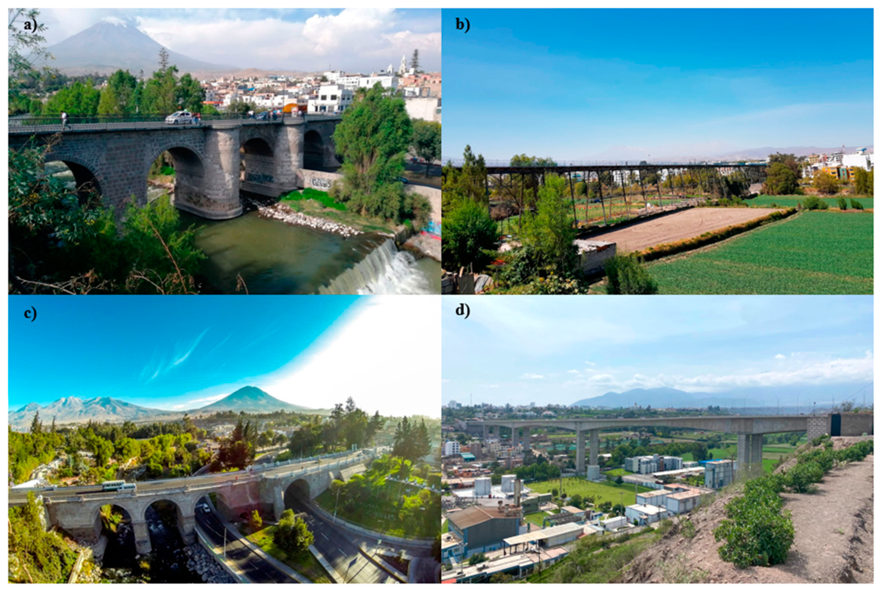
Figure 1a shows the new bridge in Arequipa (Puente Grau) of 1889, one year after its construction and subsequent operation according to its review and chronology (
Figure 2).
Figure 1b shows the Grau bridge of 1930 during the aristocratic republican transition to democracy (1895-1968).
In the 20th century, the Grau Bridge was not only one of the busiest roads, but also contributed to the urban growth of the city since its operation in 1888 (
Figure 2). However, over time, the bridge suffered serious damage. The first incident on October 21, 1953, was when the roadway and its corresponding baluster collapsed due to excessive seepage and continuous overflows from the irrigation ditch along Cortaderas de Yanahuara Street [
18], mainly due to factors such as landslides and destroyed drinking water systems that supplied the city from La Tomilla. The second in early 1975, was due to an increase in the flow of the Chili River as a result of rainfall, threatening the foundations of the Bolognesi and Grau bridges due to flooding in what is now known as Barrio Obrero eroding the pillars of the bridges [
18].
It should also be added that Spanish colonialism had a clearly urban character since the founding of Arequipa on August 15, 1540 and facilitated communication between distant cities through ports, bridges and the construction of churches [
22]. As can be seen in
Figure 3, four of the most important bridges in the city, both for their historical significance and their role in current transport system, are: Puente Viejo or Bolognesi, Puente Bolivar or Puente de Fierro, Puente Nuevo or Puente Grau, and Puente Chilina. The Bolognesi Bridge (
Figure 3a), one of the most important constructions of the colony, represented a constant concern for the local authorities, not only because of the earthquakes of 1582, 1600, 1604 and 1784, but also because of the torrential rains and the overflowing of the Chili River, such as the deluge of 1819 that caused flooding for five months [
23]. The Fierro Bridge (
Figure 3b) is now pedestrian only. Thus, in 2014, in view of the urban growth and aging of the bridges, the largest urban bridge in Peru of contemporary times was built, called Chilina Bridge (
Figure 3d), whose material is prestressed concrete 562 meters long with piers of 21.1 m, 28.9 m, 35 m and 39.7 m, and seismic analysis based on an earthquake with a return period of 1000 years [
24]. The Grau Bridge (
Figure 3c), located in the center of the city, is 62.5 m long, 10 m wide, and 17.3 m high from the riverbed, supporting more than 10,000 vehicles per day, including light and heavy vehicles.
2.2. Preliminary Hydrological Diagnosis
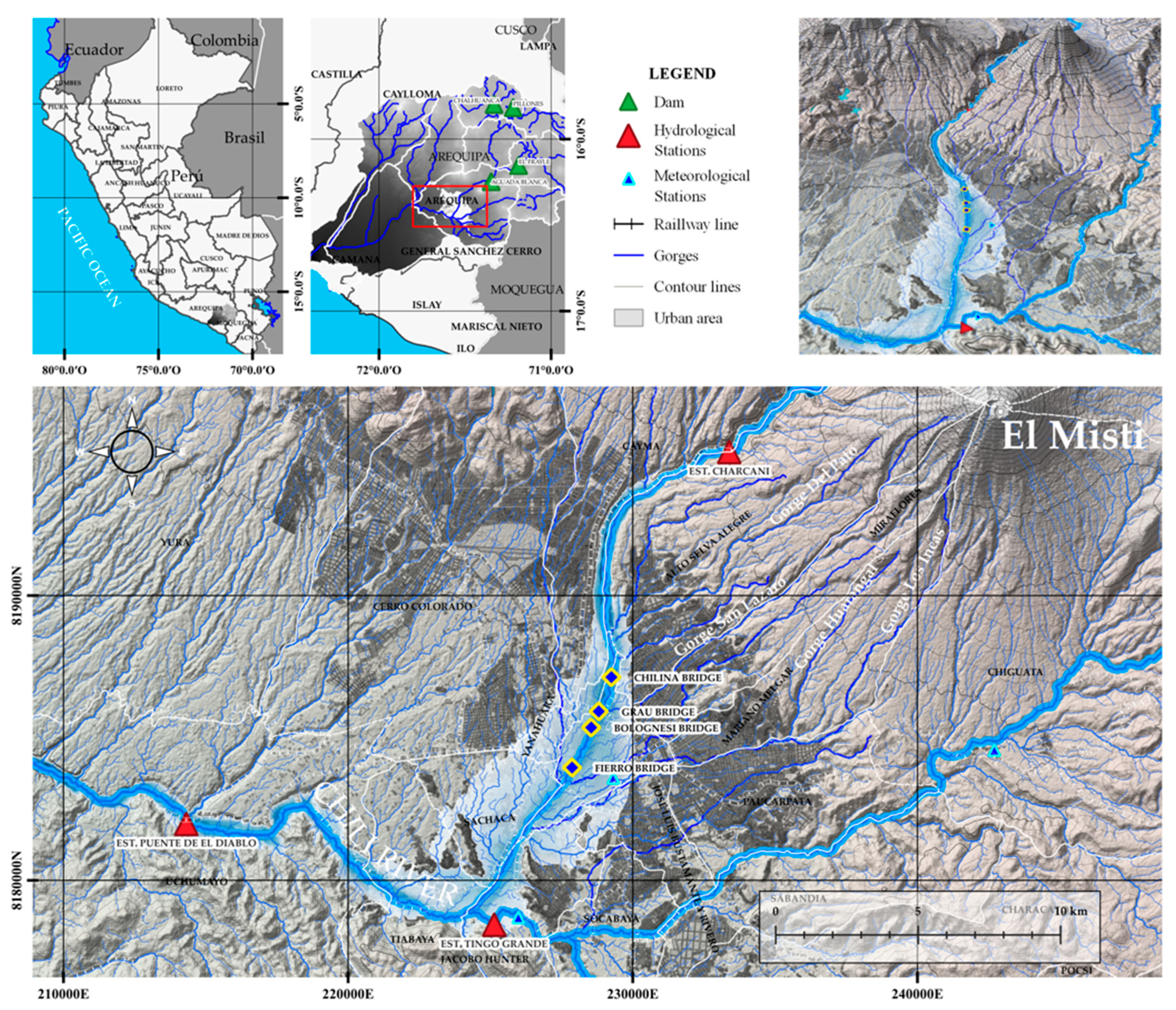
The Quilca - Chili basin (
Figure 4) is located on the Western slope of the Andes Mountains and therefore belongs to the Pacific Ocean slope. The basin has a complex system of dams called the "Chili Regulated System" to meet Arequipa's water requirements. The Chalhuanca and Pillones dams are operated and maintained by EGASA (Empresa de Generación Eléctrica de Arequipa) and AUTODEMA (Autoridad Autónoma de Majes) of the El Frayle and Aguada Blanca dams, which protect the city of Arequipa by regulating the Chili River floods. Considering the latent risk of increasingly intense and recurrent rainfall due to the effects of climate change [
26,
27], a hypothetical breach of El Frayle would cause Aguada Blanca to break, generating a wave front that would reach the city. In addition, the dams age and present sedimentation problems, causing them not to function at design volumes. As a result, some 15,000 people would be affected because the river flow would increase by approximately 1,600 m3/s [
28].
Figure 4 shows the location of the Grau Bridge in the regulated system of the basin.
An example of the hydrological vulnerability situation faced by the city was on February 8, 2013, when there was an exceptional rainfall of 124.5 mm in 3 hours [
29] and the most important creeks such as Del Pato, San Lazaro, Venezuela and Los Incas were activated, triggering a flash flood, affecting more than 280 buildings, 53 bridges (pedestrian, vehicular and railway) paralyzing the central areas of the city for more than a week [
30]. These events aggravate the situation in the city, as they harm the population substantially on many levels [
31]. In addition, it is usual for the bridges that cross the Chili River to be closed during January and February due to heavy rains, thus restricting vehicular passage [
32,
33,
34,
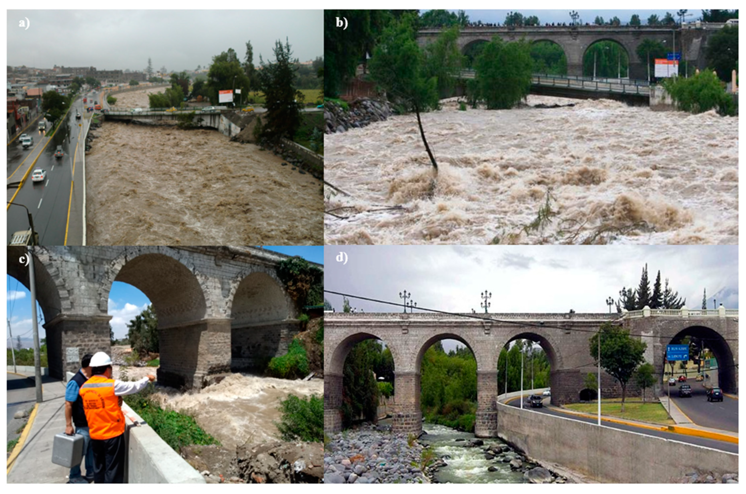
35]. Consequently, a hydrological evaluation of these bridges is necessary (
Figure 5), including a heritage conservation perspective, having already highlighted the importance of this inclusion.
3. Results
3.1. Hydrological and Hydraulic Studies
The hydrological study consisted of identifying the maximum flows in the urban area of the city of Arequipa, where the Grau Bridge is located. Hydrometric information was collected from the "Chili Regulated System", which provided by AUTODEMA with a record of 63 years (1960 - 2022) [
36]. Frequency analysis was then performed according to the Manual of Hydrology, Hydraulics and Drainage of the Ministry of Transport and Communications [MTC] [
37], for eight theoretical probability distribution functions (Normal, Log Normal II/III Parameters, Gumbel, Log Gumbel, Gamma II/III Parameters and Log Pearson type III) with seven empirical probability functions (Hazen, California, Weibull, Chegodayev, Blom, Gringorten and Cunnane) to determine the best fit to the peak flow series through the nonparametric goodness-of-fit Smirnov-Kolgmogorov test with a significance level of α=0.05. The empirical California function and the theoretical Pearson III function were the best fit.
Figure 6 shows the frequency analysis and the fit.
A useful life (n) and an allowable failure risk (R) can then be determined for the bridge. According to the Peruvian standard [
37], the R for bridges is 25% and n is 50 years. Thus, the calculation of the return period (T) of the Grau Bridge would be 174 years, but given its importance as a heritage bridge, a value of 200 years was assigned to it, to determine the Maximum Extraordinary Water Level (N.A.M.E.) and to verify a clearance gauge or height of at least 2.5 m according to the Bridge Manual [MTC] [
38]. In addition, scour was calculated for a return period of T=500 years [
37]. It should be noted that, for the hydraulic study, masonry arch bridges are particularly vulnerable to scour due to the combination of their high stiffness and shallow bases [
7].
Subsequently, the topographic survey was carried out with a DJI Phantom 4 RTK drone using the photogrammetry method, due to its high precision, stereoscopic vision and differential GPS. Contour lines were obtained every meter, georeferenced from a control point provided by the Geophysical Institute of Peru (IGN) in the World Geodetic System WGS84/UTM Zone 19S.
The hydraulic simulation was carried out with the HEC - RAS (Hydrological Engineering Center - River Analysis System) software [
39], for periods of T=50, T=100, T=200 and T=500 years to determine the behavior of the river, determining parameters such as water levels and velocities.
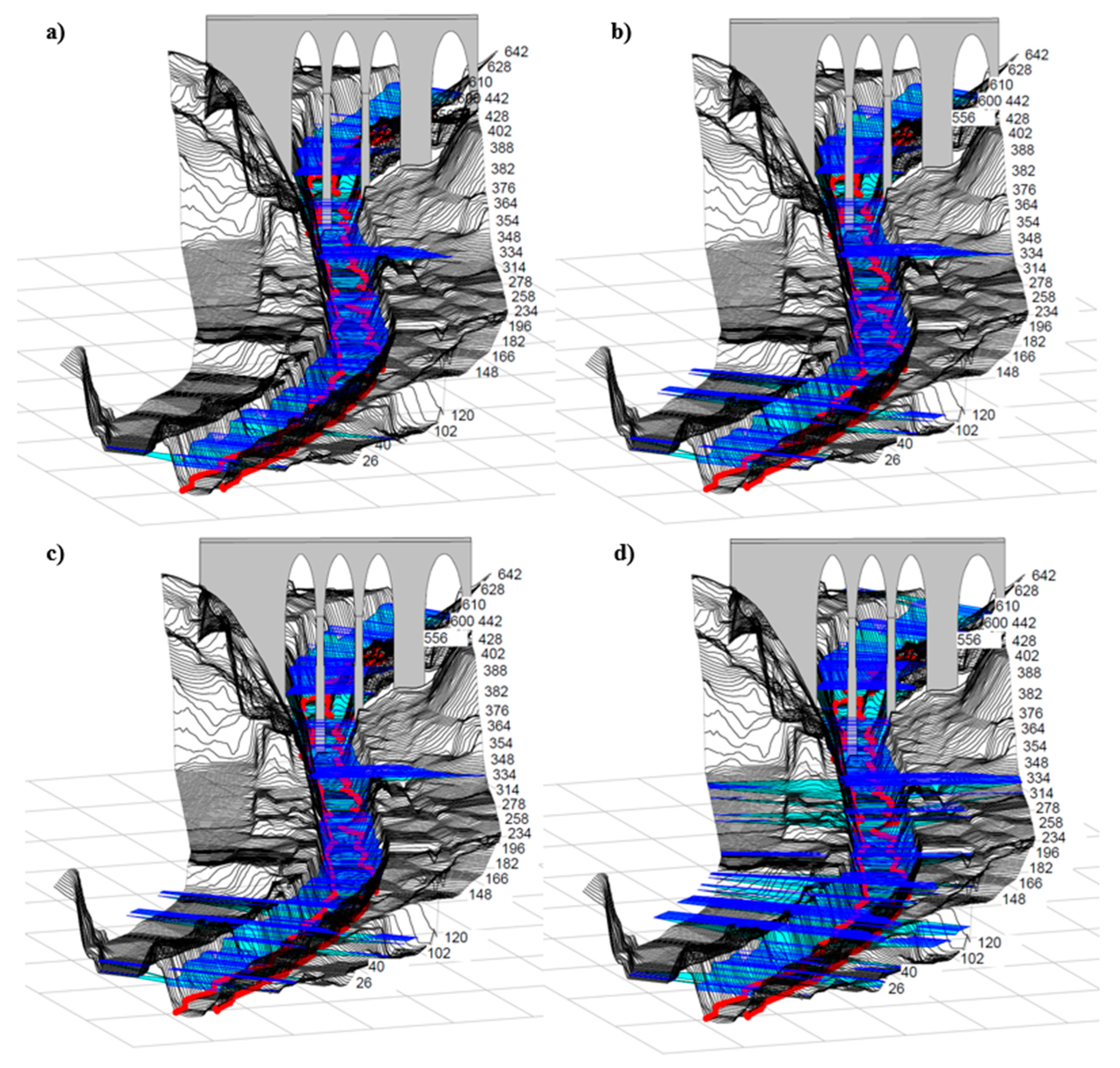
Figure 7 shows the models and the bridge located at progressive 0+448 km and
Table 1 shows the hydraulic parameters derived from the model, which include flows of 273 m3/s for T=200 years and 304.3 m3/s for T=500 years.
According to the results of
Table 1 for return periods of T=200 and T=500 years simulated one-dimensionally 1D in HEC - RAS, they show river flow velocities greater than 3 m/s, which represents erosion problems along the channel, under a mixed regime. A supercritical flow condition (Fr>1) and shear stresses greater than critical in the Km 0+448.0 section are evidenced, which represents a dragging of particles on the bed of the channel.
The city of Arequipa is faced with extreme events such as high intensity rains, but of short duration that generate floods and flooding of the Chili River [
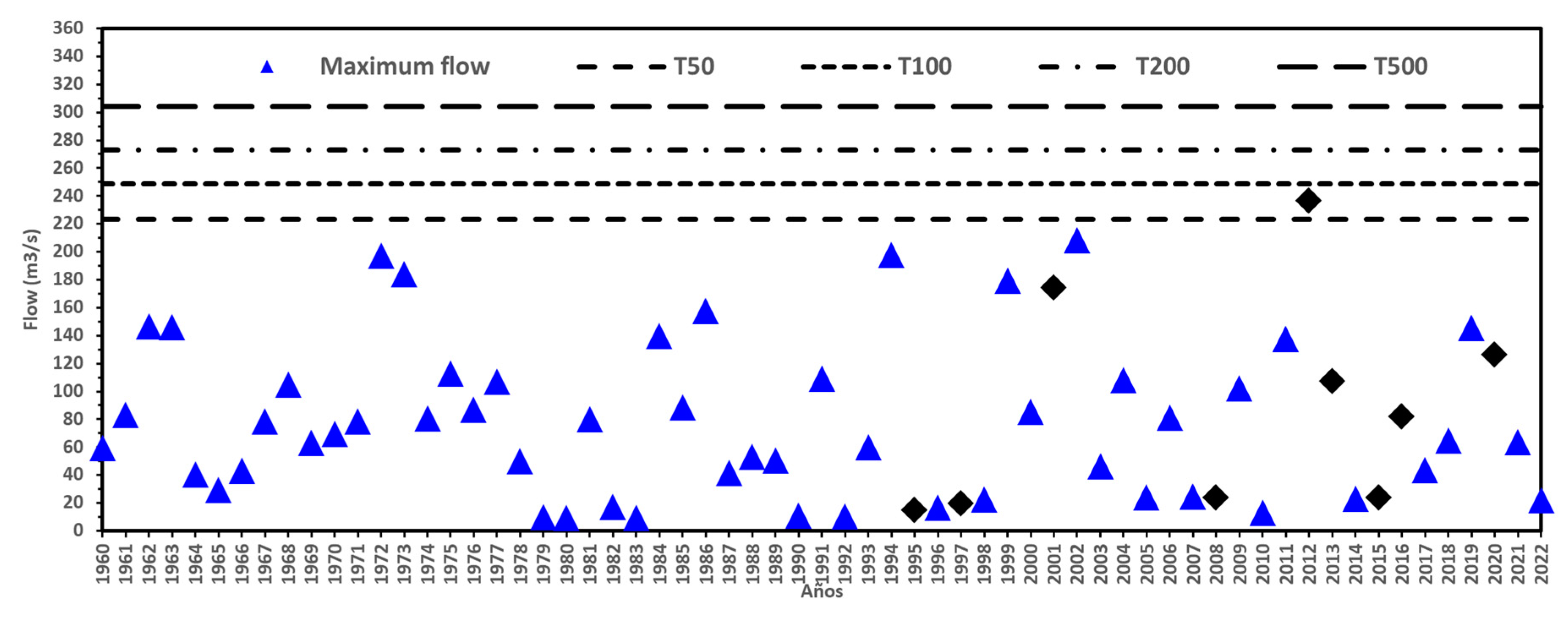
40]. Consequently, over time these extreme events triggered the activation of Del Pato, San Lazaro, Venezuela and Los Incas streams in 1995, 1997, 2001, 2008, 2008, 2012, 2013, 2015, 2016 and 2020 as historical events [
40,
41], increasing the flow of the Chili River. Thus, it can be seen in
Figure 8, flow thresholds greater than 223.0 m3/s (T=50 years) resulting from the frequency analysis of the Charcani station and flows resulting from rainfall in basins not gauged by historical events, are increasingly critical. This makes heritage bridges exposed, due to the stochastic nature of floods [
42].
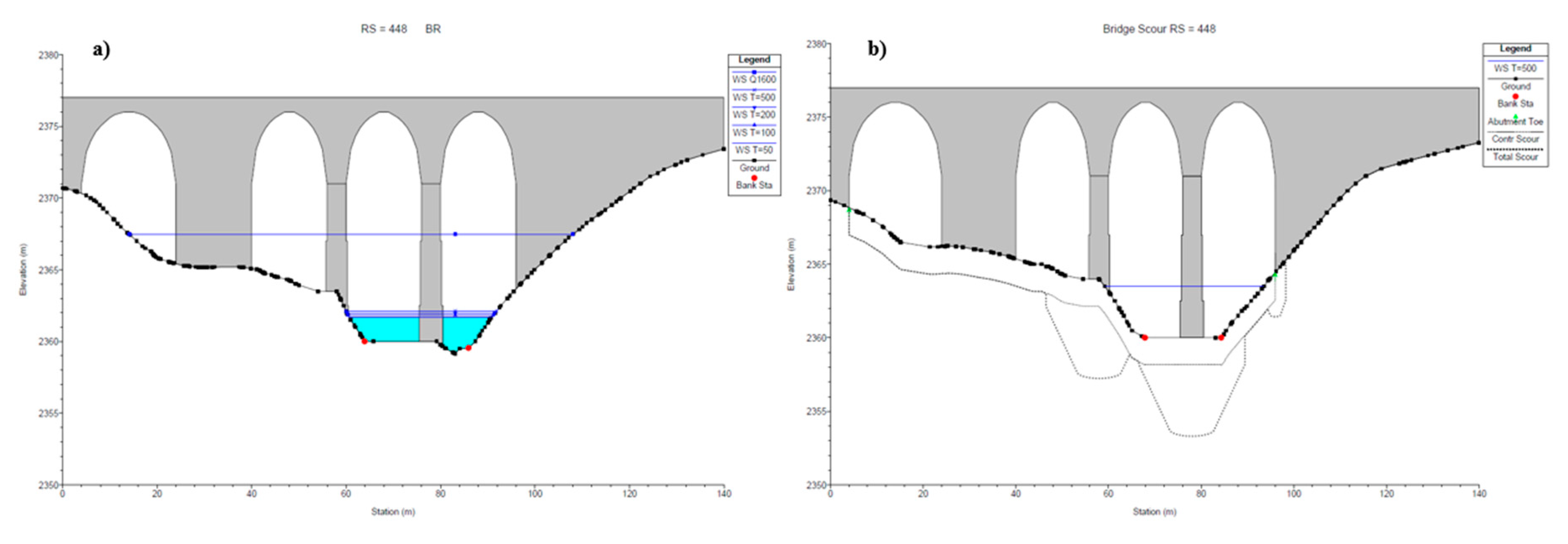
Regarding the scour study, general and local scour analyses were carried out, for which soil mechanics studies were conducted to determine the representative diameters of the bed. The d50 (decile 50) was determined as 6.5 mm. The Lischtvan-Levediev and Froehlich formula was used for non-cohesive soils. The one-dimensional (1D) hydraulic model was carried out in HEC - RAS (
Figure 9), as this type of model has been shown to generate representative results regarding flood hazards in urban environments with defined and straight channels [
42,
43]. The hydraulic simulation considered boundary conditions, contraction (0.3) and expansion (0.5) coefficients and Manning's coefficients by Cowan's method [
16]. Two hydraulic criteria were taken into account to carry out the simulation. First, for low flow, the energy equation, quantity of motion or momentum equation with dredging coefficient (Cd=1.33) was used because of the elongated piers with semicircular ends and the Yarnell equation because of the semicircular shape of the piers (K=0.9). Second, for high flow, the pressure and/or weir method with a submerged inflow and outflow coefficient of 0.8.
3.2. Multicriteria Vulnerability Analysis
Based on the literature reviewed, a multi-criteria evaluation matrix for river bridges is applied to determine the vulnerability of the Grau Bridge [
15,
16,
17]. Previously, bridges have been evaluated using this matrix, including the Grau Bridge, however, the analysis of significant parameters such as scour was not included [
17] nor was a 2D model performed for a better estimation of hydraulic parameters. The matrix has 18 evaluation parameters subdivided into 4 dimensions: environmental (A1-4), technical (T1-6) social (S1-4) and economic (E1-4). The evaluation is presented in
Table 2.
The computed average of the evaluation parameters stands at 3.6, signifying a condition of high hydrological vulnerability. This result serves as a clear indicator that intervention is imperative for the Grau Bridge. However, the Historical Review emphasizes the intrinsic heritage value of the bridge, adding a layer of complexity to the decision-making process. It underscores the need to formulate conservation measures that address the hydrological vulnerability while preserving its historical significance.
In light of this dual objective, strategic recommendations are proposed to ensure that the bridge not only meets the required levels of service for users but also mitigates the risks identified through the hydrological study. This delicate balance seeks to safeguard both the structural integrity of the bridge and its cultural heritage value, demonstrating a commitment to the preservation of historical assets while addressing contemporary challenges. The proposed recommendations aim to strike a harmonious equilibrium between functionality and heritage preservation.
3.3. Strategic Recommendations
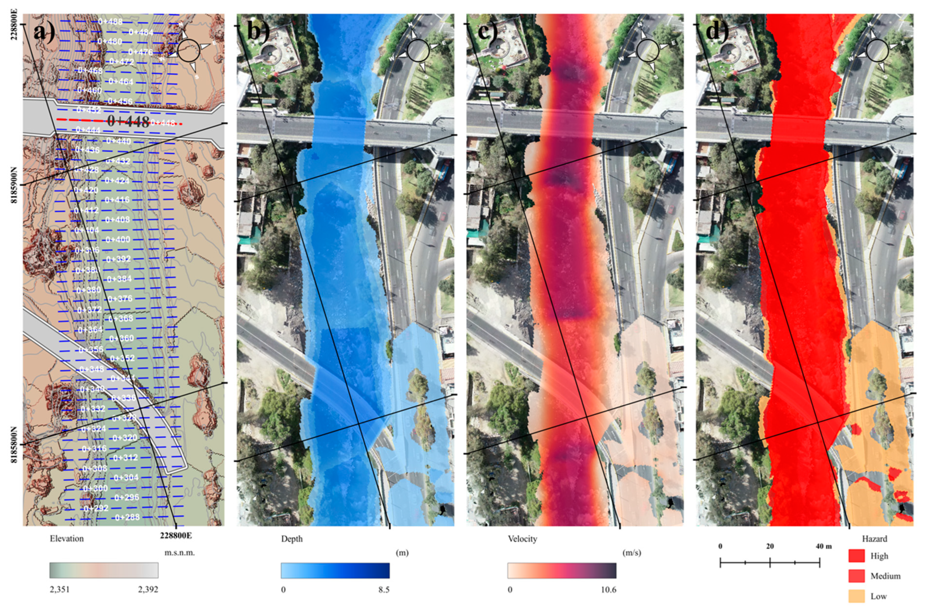
The first strategic recommendation involves the implementation of a hydrological disaster risk management system, anchored by a comprehensive risk map of the Chili riverbed. A critical step in this process is the assessment of hazards in the vicinity of the Grau Bridge. To achieve this, a two-dimensional (2D) simulation was conducted using HEC-RAS, as illustrated in
Figure 10. This simulation evaluated potential risks, encompassing not only flooding but also erosion in submerged bridges, considering a return period of T=200 years.
Water depths (
Figure 10b), maximum velocities (
Figure 10c), and the flood hazards (
Figure 10d) were identified through a risk matrix. This matrix integrated hydrostatics and hydrodynamic forces to gauge the erosive potential of water during a maximum flood event. QGIS software served as the Geographic Information System tool, relying on calculations of raster pixel values [
45]. This facilitated the identification of the hazard zone in the Grau Bridge location, promoting integrated risk management and enhancing resilience for formal planning versus informal growth [
46,
47] in the face of extreme events (
Figure 10d). The strategic application of this hydrological disaster risk management system is vital for proactive planning and response to safeguard critical infrastructure like the Grau Bridge against potential hydrological threats.
The second recommendation advocates for the continuous 24-hour monitoring of water velocities and levels during the Chili River flood season. This is to be achieved through accelerometers as an integral part of the Digital Twins implementation. Sensors will be strategically placed in the abutments and pillars of the Grau Bridge to furnish hydraulic and structural information related to scour and erosion in the bridge foundation. This data will prove invaluable for those responsible for managing the infrastructure. Additionally, comprehensive inspection protocols are deemed necessary for various elements of heritage and historic bridges, encompassing arches, vaults, supports, joints, pillar foundations, and abutments. These protocols will utilize valuation indexes to systematically assess and mitigate risks.
The third recommendation underscores the importance of implementing strategies for participatory community approaches. Given that heritage bridges are often situated in historic city centers and primary riverbeds that serve as water sources for consumption and economic activities, they constitute an integral part of the built environment. Therefore, it is imperative for the entire population to share in the responsibility of caring for these structures. Community approaches should extend to the establishment of early warning systems aimed at mitigating the risks associated with extreme events. This holistic involvement of the community is essential to ensure the long-term preservation and resilience of heritage bridges within the built environment.
4. Discussion and Conclusions
The urban landscapes of numerous cities worldwide, particularly in Latin America, encompass historical heritage, including bridges. As this type of infrastructure frequently approaches the end of its operational life, it struggles to meet the everevolving demands of users. Furthermore, the escalating severity and recurrence of extreme events amplify the vulnerability of these structures. Among the leading causes of bridge failures are those stemming from flood-related incidents, which induce scour, flooding, and other consequential effects. In light of these considerations, the authors acknowledge the significance of preserving heritage bridges situated in river channels and propose an evaluation methodology from a hydrological perspective, utilizing the Grau Bridge in Arequipa, Peru, as a case study.
The primary outcomes of the study emphasize the bridge's importance not only from a historical standpoint but also in terms of its relevance to the city's transportation system. This characterization is meticulously detailed in the Historical Review of the bridge. Subsequently, a Preliminary Hydrological Diagnosis was conducted, compiling data on the bridge's vulnerability and providing descriptions of the river and the regulated system. These initial steps were informed by an extensive review of existing literature.
Following these preparatory stages, Hydrological and Hydraulic Studies were undertaken. Four scenarios were proposed based on the type and significance of the structure. A drone survey of the riverbed and the bridge, as well as soil studies, were conducted. Utilizing these input parameters, 1D and 2D hydraulic models were created in HEC-RAS to determine the Extraordinary Maximum Water Level (E.M.L.L.) and assess scour in the foundation. These studies were pivotal for the Multicriteria Vulnerability Analysis, precisely incorporating parameters such as EMLL and scour in abutments and piers.
The vulnerability assessment revealed a high level of risk for the bridge, prompting the formulation of strategic recommendations for its conservation. These recommendations include the implementation of a hydrological disaster risk management system, leveraging emerging technologies like Digital Twins. This approach involves the installation of sensors on the bridge for continuous monitoring, ensuring minimum service levels and mitigating risks associated with the bridge's interaction with the flow. In conclusion, this study contributes to the enhanced management of vital infrastructure, particularly heritage bridges. Moreover, the proposed methodology is adaptable for the examination of bridges with similar characteristics.
Author Contributions
Conceptualization, J.C.P.; methodology, J.C.P. and A.J.E.V.; formal analysis, J.C.P., A.J.E.V. and A.V.H.V.; investigation, J.C.P. and A.J.E.V.; data curation, J.C.P.; writing—original draft preparation, J.C.P. and A.J.E.V.; writing—review and editing, A.J.E.V. and J.B. All authors have read and agreed to the published version of the manuscript.
Funding
This research received no external funding.
Data Availability Statement
The findings of this research are supported by the data available from the corresponding author, J.C.P., upon reasonable request.
Conflicts of Interest
The authors declare no conflict of interest.
References
- Ravines, J. Proceso urbano de la vivienda centro histórico de Arequipa. Devenir 2023, 10, 182–185. [Google Scholar] [CrossRef]
- Palpan, S. Management, Interventions and Stakeholders in the Recovery of the Historic Center of Rimac (1991-2018). Devenir 2023, 10, 61–84. [Google Scholar] [CrossRef]
- UNESCO. The Historical Centre of the City of Arequipa, Convention concerning the protection of the world cultural and natural heritage. United Nations Educational, Scientific and Cultural Organization. Australia. 2000. Available online: https://whc.unesco.org/archive/2000/whc-00-conf204-21e.pdf (accessed on 3 August 2023).
- INEI. Arequipa alberga a 1 millón 316 mil habitantes. Instituto Nacional de Estadística e informática. Lima, Perú. 2017. Available online: https://m.inei.gob.pe/prensa/noticias/arequipa-alberga-a-1-millon-316-mil-habitantes-9903/#:~:text=Con%20motivo%20del%20477%20aniversario,a%C3%B1os%2C%2064%2C3%25%20tiene (accessed on 3 August 2023).
- Naranjo, J.A.; Clavero, J.E. A rare case of grass flow induced by the M8.4 Arequipa earthquake, June 2001, in the Altiplano of Northern Chile. Quaternary Research 2005, 64, 242–248. [Google Scholar] [CrossRef]
- Puma, M.; Guerrero, E.; Copa, J.; Copa, F. Experimental Study of the Seismic Behavior of Two-Leaf Masonry Wall with and Without Confinement. Structural Analysis of Historical Constructions, ed.; Aguilar, R., Torrealva, D., Moreira, S., Pando, M.A., Ramos, L.F. Bookseries, Springer, Cham, 2019; 18, 1697-1705. [CrossRef]
- Pregnolato, M.; Winter, A.O.; Mascarenas, D.; Sen, A.D.; Bates, P.; Motley, M.R. Assessing flooding impact to riverine bridges: An integrated analysis. Natural Hazards and Earth System Sciences 2022, 22, 1559–1576. [Google Scholar] [CrossRef]
- INDECI. Compendio Estadístico del INDECI 2017 Gestión Reactiva. Instituto Nacional de Defensa Civil. Lima, Perú. 2017. Available online: https://cdn.www.gob.pe/uploads/document/file/1048401/20180227171454120200409 726-15599-1ptpifw.pdf (accessed on 3 August 2023).
- Espinoza, A.J.; Booker, J.D. Building national disaster resilience: Assessment of ENSO-driven disasters in Peru. International Journal of Disaster Resilience in the Built Environment 2023, 14, 423–433. [Google Scholar] [CrossRef]
- Tubaldi, E.; White, C.J.; Patelli, E.; Mitoulis, S.A.; Almeida, G.; Brown, J.; Cranston, M.; Hardman, M.; Koursari, E.; Lamb, R.; McDonald, H.; Mathews, R.; Newel, R.; Pizarro, A.; Roca, M.; Zonta, D. Invited perspectives: Challenges and future directions in improving bridge flood resilience. Natural Hazards and Earth System Sciences 2022, 22, 795–812. [Google Scholar] [CrossRef]
- Noticias San Pablo. Falta de Mantenimiento Pone en Riesgo Integridad de Puentes de Arequipa. Noticias San Pablo. 2021. Available online: https://ucsp.edu.pe/falta-mantenimiento-pone-en-riesgo-integridad-puentes-arequipa (accessed on 3 August 2023).
- Everett, C.; Rosnell, A.; Rankin, M. Replacement of cast iron piers on an 1886 wrought iron truss bridge in New South Wales, Australia - the challenge of preserving heritage significance during major rehabilitation work. Conservar Patrimonio 2023, 44, 187–198. [Google Scholar] [CrossRef]
- Mamani, E.A.; Apaza, E.; Gonzales, D.; Vargas, H.; Guerra, E.; Andrade, D.M.; Nacsa, B.; Ferreira, J.P.; Gomes, F.J.; Farias, C.R. Microstructural and mechanical characterisation of the Simon Bolivar's iron bridge structure, 19th century, Arequipa, Peru. Metallurgy and materials 2020, 73. [Google Scholar] [CrossRef]
- Thouret, J.C.; Enjolras, G.; Martelli, K.; Santoni, O.; Luque, J.A.; Nagata, M.; Arguedas, A.; Macedo, L. Combining criteria for delineating lahar and flash flood prone hazard and risk zones for the city of Arequipa, Peru. Natural Hazards and Earth System Sciences 2013, 13, 339–360. [Google Scholar] [CrossRef]
- Thouret, J.C.; Ettinger, S.; Guitton, M.; Santoni, O.; Magill, C.; Martelli, K.; Zuccaro, G.; Revilla, V.; Charca, J.A.; Arguedas, A. Assessing physical vulnerability in large cities exposed to flash floods and debris flows: The case of Arequipa (Peru). Natural Hazards and Earth System Sciences 2014, 73, 1771–1815. [Google Scholar] [CrossRef]
- Espinoza, A.J.; Booker, J.D. Hydrological Vulnerability Assessment of Riverine Bridges: The Bajo Grau Bridge Case Study. Water 2023, 15, 846. [Google Scholar] [CrossRef]
- Huarca, A.; Espinoza, A.J.; Booker, J.D. Príoritizing Riverine Bridge Interventions: A Hydrological and Multidimensional Approach. Designs 2023, 7, 117. [Google Scholar] [CrossRef]
- Bedregal, J. El puente Grau algunos aspectos históricos. 1st ed.; Arequipa, Perú, 2015.
- Arce, M.R. Calles, plazas y puentes de Arequipa, 1sd ed.; Adrus, Arequipa, Perú, 2012.
- Arequipa Tradicional. El Puente Grau. Arequipa Tradicional. 2013. Available online: https://fotovintagearequipa.blogspot.com/2013/08/el-puente-grau.html (accessed on 3 August 2023).
- Municipalidad Provincial de Arequipa. Puente Grau. Municipalidad Provincial de Arequipa. 2019. Available online: https://gcentrohistoricoaqp.blogspot.com/2019/04/puente-grau-el-puente-grau-454 fue.html (accessed on 3 August 2023).
- Boza, M.F. Bridge and Boundary: The Maritime Connections of Colonial Arequipa, Peru. International Journal of Historical Archaeology 2022, 26, 291–315. [Google Scholar] [CrossRef]
- Meza, M.; Condori, V. Historia mínima de Arequipa: Desde los primeros pobladores hasta el presente. 1sd ed.; Institución de Estudios Peruanos, Lima, Perú, 2018.
- Capellan, G.; Sacristan, M. Chilina Bridge over the Chili River in Arequipa. Balanced cantilever segmental bridge in high seismicity area. Engineering for Progress, Nature and People 2014, 102, 2110–2117. [Google Scholar] [CrossRef]
- Machupicchu Terra. 4 puentes importantes e históricos en Arequipa. Machupicchu Terra. 2023. Available online: https://www.machupicchuterra.com/es/guia/puentes-importantes-arequipa/ (accessed on 3 August 2023).
- CAF. Vulnerabilidad y adaptación al cambio climático en Arequipa Metropolitana. Corporación Andina de Fomento. Perú. 2018. Available online: https://scioteca.caf.com/handle/123456789/1181 (accessed on 3 August 2023).
- ANA. Plan de Gestión de los Recursos Hídricos de la cuenca Quilca-Chili. Autoridad Nacional del Agua. Arequipa, Perú, 2015. Available online: https://hdl.handle.net/20.500.12543/86 (accessed on 3 August 2023).
- Andina. Realizan simulacro de inundación en Arequipa por colapso de represa. Andina. 2015. Available online: https://andina.pe/agencia/noticia-realizan-simulacro-inundacion-arequipa-colapso-represa-586825.aspx (accessed on 3 August 2023).
- Cacya, L.; Meza, P.; Carlotto, V.; Mamani, L. Aluvión del 8 de febrero del 2013 en la ciudad de Arequipa. Foro Internacional Peligros Geológicos 2013, 195–200, https://hdl.handle.net/20.500.12544/1132. [Google Scholar]
- Ettinger, S.; Mounaud, L.; Magill, C.; Yao, A.F.; Thouret, J.C.; Manville, V.; Negulescu, C.; Zuccaro, G.; De Gregorío, D.; Nardone, S.; Luque, J.A.; Arguedas, A.; Macedo, L.; Manrique, N. Building vulnerability to hydro-geomorphic hazards: Estimating damage probability from qualitative vulnerability assessment using logistic regression. Journal of Hydrology 2016, 541, 563–581. [Google Scholar] [CrossRef]
- Gestión. Arequipa: Las perdidas por inundaciones podrían superar los S/. 350 millones. Gestión. 2013. Available online: https://gestion.pe/economia/arequipa-perdidas-inundaciones-487 superar-s-350-millones-31633-noticia/ (accessed on 3 August 2023).
- El Búho. Arequipa: Peligrosa crecida del río Chili tras intensas lluvias. El Búho. 2020. Available online: https://elbuho.pe/2020/02/arequipa-crecida-del-río-chili-tras-intensas-lluvias-video/ (accessed on 3 August 2023).
- Naufragantes. Arequipa - Puente Bajo Grau Cerrado y Puente Grau en doble sentido. Naufragantes. 2011. Available online: https://naufragantes.wordpress.com/2011/02/23/arequipa-puente-bajo-grau-cerrado-y-puente-grau-en-doble-sentido/ (accessed on 3 August 2023).
- Diario Correo. Autoridades de Arequipa ordenan el cierre de dos puentes. Diario Correo. 2023. Available online: https://diaríocorreo.pe/peru/autoridades-de-arequipa-ordenan-el-cierre-de-dos-puentes-508647/ (accessed on 3 August 2023).
- Andina. Cierran puentes en Arequipa por incremento del caudal del río Chili. Andina. 2012. Available online: https://andina.pe/agencia/noticia.aspx?id=399604 (accessed on 3 August 2023).
- AUTODEMA. Movimiento Hídrico. Autoridad Autónoma de Majes, 2022. Available online: https://www.autodema.gob.pe/movimiento-hidrico/ (accessed on 3 August 2023).
- MTC. Ministerio de Transporte y Comunicaciones. Manual de Hidrología, Hidráulica y Drenaje. Lima, Perú. Available online: https://portal.mtc.gob.pe/transportes/caminos/normas_carreteras/manuales.html (accessed on 3 August 2023).
- MTC. Ministerio de Transporte y Comunicaciones. Manual de Puentes. Lima, Perú. Available online: https://portal.mtc.gob.pe/transportes/caminos/normas_carreteras/manuales.html (accessed on 3 August 2023).
- HEC. HEC-RAS 1D/2D User's Manual. 2021. Available online: https://www.hec.usace.army.mil/confluence/rasdocs/r2dum/latest (accessed on 3 August 2023).
- Ccanccapa, J.; Hidalgo, V.A.; Noriega, G.Y.; Chavez, A.E.; Marques, M. Analysis and risk prevention due to floods in high-risk gorges in the city of Arequipa – Perú. Tecnología y Ciencias del Agua 2024, 15. [Google Scholar] [CrossRef]
- Vílchez, M.; Sosa, N. Peligro geológico por movimientos en masa en la ciudad de Arequipa. Geodinámica e Ingeniería Geológica, 2021, 85. https://hdl.handle.net/20.500.12544/3186. [Google Scholar]
- Lamb, R.; Aspinall, W.; Odbert, H.; Wagener, T. Vulnerability of bridges to scour: Insights from an international expert elicitation workshop. Natural Hazards and Earth System Sciences 2017, 17, 1393–1409. [Google Scholar] [CrossRef]
- Hutanu, E.; Mihu, A.; Urzica, A.; Paveluc, L.E.; Constantin, C.; Grozavu, A. Using 1D HEC-RAS Modeling and LiDAR Data to Improve Flood Hazard Maps Accuracy: A Case Study from Jijia Floodplain (NE Romania). Water 2020, 12, 1624. [Google Scholar] [CrossRef]
- Martínez, R.A.; Álvarez, M.; Rodriguez, Y.; Lazaro, C.; Jimenez, J.; Dores, L.; Gonzales, L. Simulating the Flood Limits of Urban Rivers Embedded in the Populated City of Santa Clara, Cuba. Water 2023, 15, 1805. [Google Scholar] [CrossRef]
- Ferreira, P.; Moya, J.; Pires, M. An in-depth look at the application of GIS for industrial heritage documentation. Conservar Patrimonio 2023, 44, 67–81. [Google Scholar] [CrossRef]
- Zeballos, C. Urban Linkages: A Methodological Framework for Improving Resilience in Peripheral Areas: The Case of Arequipa, Peru. Handbook of Quality of Life and Sustainability, ed.; Martinez, J., Mikkelsen, C.A., Phillips, R., Book series, Springer, Cham, 2021; 553-550. [CrossRef]
- Zeballos, C.; Yory, C.M.; Chui, E.; Zuluaga, L. Urban renovation in the edges of the city: An urban acupuncture exercise in Arequipa and Bogotá. Estudios Demográficos y Urbanos 2022, 37, 265–305. [Google Scholar] [CrossRef]
|
Disclaimer/Publisher’s Note: The statements, opinions and data contained in all publications are solely those of the individual author(s) and contributor(s) and not of MDPI and/or the editor(s). MDPI and/or the editor(s) disclaim responsibility for any injury to people or property resulting from any ideas, methods, instructions or products referred to in the content. |
© 2024 by the authors. Licensee MDPI, Basel, Switzerland. This article is an open access article distributed under the terms and conditions of the Creative Commons Attribution (CC BY) license (http://creativecommons.org/licenses/by/4.0/).

