
Submitted:
31 May 2024
Posted:
31 May 2024
You are already at the latest version
Abstract
Using the limits of a specific watershed (river basin) to establish boundaries of precise rural and urban intervention strategies, can conduce to a better understanding of the dynamics between natural hydro-morphology of a hydrological region, water infrastructures (damns, canals, reservoirs) and urban and rural fabric. To perform watershed-based planning approaches with valuable indicators is necessary to generate hybrid cartographies combining urban, architectural, agricultural and hydrological boundaries. In some countries, the necessary information to produce these cartographies is not available; however, is possible to create fundamental layers using GIS software and national geospatial information and subsequently perform algorithmic calculations in the same software. Once these cartographies are developed and analyzed for a determined basin is possible to observe scenarios where rural and urban planning are better suited for precise hydric-urban restoration. In the following article a series of hybrid cartographies are presented. These types of maps are useful for interpretation of water usage flow in rural communities and their agricultural productive surfaces, and ultimately for analytical purposes in dealing with hydrological alterations of the water cycle. The diagnostic results can be used to develop specific rural interventions for fluvial restoration in territorial contexts, and improvement on hydrological infrastructure and the hydrological region water network.
Keywords:
Fluvial restoration
; rural planning
; water stress
; water footprint
; rural strategies.
1. Introduction
The goal of this research is to develop a methodology for the generation of water cartographies through a geographic basin approach in order to improve redevelopment rural strategies. For this, the geostatistical and cadastral data available in the Mexican territory are incorporated and applied in the context an specific hydrological region. When the vectorized information does not exist or is not suitable for use within Geographic Information Systems (GIS) It is created using the tools included on GIS software.
The object of study is the hydrological region RH36. This region contains the Nazas and Aguanaval river basins located in the northwest area of Mexico. These basins have a high degree of pressure on water resources. A first approximation to the region is produced through the lecture of available geospatial information, which allows to recognize a series of deficiencies in the different scales of analysis, but mainly in the territorial scale (less than or equal to 1:50,000) and in rural communities outside the urban perimeters. Although the National Institute of Statistics and Geography in Mexico (INEGI) provides national geospatial data, the production of local information depends on decentralized organizations with variable size and budget. Although the development of cadastral information is an urgent national project, it is still underdeveloped in Mexico. Although there is information available on some larger urban areas within the hydrological region 36, like the city of Torreón, such cadastral information does not include building footprints, a type of data information which is fundamental for morphological studies. Taking into account that a regional restoration project requires homogeneity in the information of all the populations involved in the administration and consumption of water resources, it is essential to produce cartographic material that allows us to define the dynamics between the systems of communities and the hydrographic basins they belong to.
In addition to cadastral and building information, it is necessary to include water indicators, and the morphology of agricultural surfaces. With this process is possible to identify productive dynamics, and the percentage of used and available areas in the domains of a specific hydrographic basin. By incorporating these different layers of information, is possible to understand the logics of settlement and production of a set of rural communities and their essential relationship with the water cycle. To know the form of the territory is essential to understand the relevant processes in the transformation of the biophysical matrix, and is necessary to understand the formal result of the territorial order [1]. Is in this knowledge and through the power of the definition of the components of the territory [2] that alternatives can be synthesized to improve the productive dynamics of the communities within the limits of hydrographic basins.
The cartography produced by the analysis of the components of the territory allows to visualize a series of hydric-rural maps that together constitute a base knowledge that considers all the communities of the region as a fundamental part of a fluvial restoration project. Using water as the common thread; will make possible to visualize the system in a multi-scale scope, and the effects on water flows and the hydrological cycle of the region. With this information it will be possible to promote strategies aimed to improve water stability, but also urban-productive and rural-productive scenarios for all the communities placed in the water basin limits. The paper presents the development of a methodology based on 4 main scales. The goal of this methodology is the generation of rural-hydric cartographies, proceeding from the largest territorial scale to a more local urban scale.
2. Work Scales. Units of Analysis in Territories under High Water Stress
In this section of the research, in addition to the physical limits, the theoretical-conceptual margins of the hydrographic basins are determined. These units of analysis define the limits of the research, that is, the defined borders of the hydrographic basins determine the number of rural and urban communities to be evaluated for a total scope of the region. The communities, their road infrastructure and productive spaces will integrate the general scope of the study. The purpose is to recognize a focus on hydrological regions, their basins and subdivisions as a starting point for the approach to water basin restoration. According to Cotler and Caire [3] planning and management in the context of a basin enables a global and systemic vision of the territory. Within this basin planning, the main polluting sources, their intensities and impacts on the eco-hydrological dynamics can be determined. The foregoing five work scales are established in order to prioritize work areas, and facilitate collaboration between institutions for the consistency of rural and urban planning actions. In this sense, the integrated management of watersheds, as a process, represents an appropriate method to relate science, politics and public participation.
2.1. Hydrological Region 36
In the Mexican territory, 37 hydrological regions (RH) have been identified (Figure 1 and Table 1). These regions are subcategorized in basins and sub-basins to integrate the hydrographic systems. The limits of these regions are represented by the geographic borders of the basins they group. Although there is another model for grouping the basins developed by CONAGUA called the Administrative Hydrological Region (RHA) and which by scale would precede the RH, in this study it is decided to use the limits of the hydrological regions since this unit respects the morphological, orographic and hydrological features of the territory, (RHA group divisions to facilitate the administration of water resources).
2.2. Hydrographic Basin
Hydrological Region 36 is a hydrographic system conformed by 5 basins and 33 sub-basins according to the information from the hydrographic network developed by INEGI (Figure 2). It is observed that, because the basin preserves certain geomorphological characteristics and that within the spectrum of urban studies the delimitation of the object of study is relevant, in this research it is decided to use the basin as a first approximation to the territory:
"Hydrographic basins are considered the basic territorial unit for the planning and management of natural resources, as well as a fundamental spatial and temporal dimension for adaptation to climate change."
“There is discussion on a basin approach when, in a territorial management process, the relationship between the territories and the users of the upper and lower basins is made explicit. This means, all the impacts generated by the activities in the upper basin towards the lower part of the basin are considered. Likewise, the ecosystem services provided by the basin are recognized.” [4]
2.3. Hydrographic Sub-Basin
To explore into smaller approach scales the sub-basins are considered within the framework of this research. Following the hierarchy of the geographic network, as in the previous graphics, the geospatial information is integrated using QGIS software, from which the surfaces and limits are calculated.
“[The sub-basin is] the land whose surface runoff flows in its entirety through a series of streams, rivers and, eventually, lakes towards a certain point of a water course (generally a lake or a confluence of rivers).” [5]
The hydrological region 36 contains 33 sub-basins according to INEGI information available in its vectorized information. To calculate the number of inhabitants of each sub-basin, a database has been generated by adding the attributes of the 2020 geostatistical framework through the Single Catalog of Keys for State, Municipal and Local Geostatistical Areas (Catálogo Único de Claves de Áreas Geoestadísticas Estatales, Municipales y Localidades) (Figure 3). The area of each sub-basin can be calculated from the properties of the geometry provided in the vectorized information from INEGI. The resultant map is a unification of geographical and cadastral information. This type of map is important to visualize the basins and sub-basins with a higher concentration of population, and therefore a higher degree of domestic water consumption. It is important to mention that the sub basins RH36A, the north of RH36D, and RH36E conform the lower basin of the hydrological region 36, and they also concentrate more than 90% of the population in the entire region.
2.4. Micro-Basin
At a micro-basin scale, it is necessary to determine particular areas of study through specific standards, since the geospatial information of micro-basins is not included in the Hydrographic Network edition 2 (Figure 4). The geospatial data for micro-basins can be generated from the geodata of the sub-basin that the micro-basin belongs to. For this, is necessary to focus on a specific water stream at smaller scale. The micro-basin constitutes a reduced domain that is suitable for partial rural and urban planning actions.
“The planning unit is the water basin. However, the basic unit of management and intervention is the micro-basin, where production can be managed and visualized in relation to the flow of water. In order to describe the different uses of the land, it is necessary to work with large scales to represent the plot or production unit regardless of its size”. [6]
2.5. Urban Basin
The urban basin is the last boundary considered within the hierarchical order of hydrological regions in this research (Figure 5). According to Agredo [7] it is in the hydrographic basin where rural and urban processes of human communities originate and interact with the hydrological network. Social, economic, political and cultural activities are supported by artificial technological systems developed at the expense of the natural system. Therefore, it is considered a fundamental approach to understand the hydrological phenomena at the scale of the city and their elements, and so, to have fundamental impacts to implement development strategies.
On this scale of order (city – architecture) is possible to observe the dynamics on the consumptive uses of water, which are closer to the citizen. For example, one can observe the construction typologies and determine the amount of water needed to build the individual construction materials, and trough this identify an approximate of water footprint per m3 of construction. Another example of analysis at this scale is on the relationship between buildings and canals through their façade fronts. The type of soil, waterproofing, urban basin drainage, infiltration and recharge capacities with their disruptions to the hydrological cycle can also be observed.
The results obtained from the different analysis carried out between the very fabric of the cities and the road structure that articulates them can provide relevant information for the reordering and identification of harmful trends within the hydrological cycle of a given basin.
In the urban basin, the degree of disruption of the natural system is higher compared to the territorial scales. However, unlike large areas at the territorial scale, the urban scale offers greater control over drainage systems, and support to water flows. That is why, in territories under water stress, attention to solutions that promote recharge and re-naturalization of environmental catchment surfaces is mainly relevant, especially if large urban populations concentrated within these surfaces. This is the case of the lower basin located in the hydrological region 36 where the populations of Torreón, Gomez Palacio, Lerdo and Matamoros are positioned. These communities together form the metropolitan area of La Laguna (ZML) which concentrates around 90% of the population in the lower sub-basin of the Nazas and Aguanaval rivers.
3. Regional Scale
As Eizaguirre explains [1], geomorphology teaches us that certain geographical, biotic, geological and anthropic factors trigger a series of constructive and destructive processes, in constant dynamics. Therefore, the terrestrial surface that we observe is not a fixed reality, it is in permanent mutation. This reality guides us towards reading the components of the territory both isolated and in their hierarchical order over time.
Geographical representations are used on this research to understand the hierarchical structure of the hydrological region. An example of this are the specific large-scale regional maps drawn and based on available satellite information. Generally, to work in these dimensions, satellite data can be directly integrated into QGIS through plugins such as quickmapservices. However, when satellite captures are available with a higher degree of precision for certain areas, it is advisable to work with this information. For example: in Catalonia, the Institut Cartogràfic i Geològic de Catalunya (ICGC) has a catalog of orthophotos, aerial images and monthly captures from the sentinel-2 satellite.
In the case of the hydrological region 36, satellite information from Google Earth and the quickmapservices tool are used. The information is integrated into the Lambert Conformal Conic projection (LCC) Datum: ITRF2008. Ellipsoid: GRS80, because the geospatial data provided by INEGI is generated in this projection (Figure 6). The result is, information standardized to the cartographic language of the Mexican Institute of Statistics.
This is the first approach to the hydrological region under study. In this scale large flat areas and elevations can be appreciated, and some location of the hydrological infrastructure and the main geological characteristics can also be identified. From Left to right the hgher sub-basins and on the top right corner the lower sub-basins.
4. Geographic and Geomorphologic Scale
4.1. The Strahler Diagram and the Urban Morphology of the Basin
The benefit of combining hydrographic, urban and agricultural information within the same cartography is that allows us to visualize, on the one hand, the anthropized percentage of a specific hydrographic basin and, on the other, the different degrees of soil permeability according to the type of cover. These indicators influence the fluvial recharge dynamics of the groundwater levels and consequently the continuity of the hydrological cycle. Additionally, through them, settlement patterns and degree of pressure on both surface and underground water resources can be identified.
In order to understand the complexity and hierarchy of the hydric ramifications in a defined river basin, it is decided to use the numerical form of Strahler (Figure 7). Information on hydrographic networks can be obtained from specialized sources such as the National Water Commission in Mexico (CONAGUA). However, if these data are not available for a certain region, they can be calculated through DEM images and the QGIS software.
Once the hydrographic network has been incorporated, within a defined cartographic projection, it is necessary to add the available geospatial data from the rural and urban settlements to be analyzed. For this, it is required to access vector information from the urban and rural blocks, which in this case comes from the INEGI geostatistical framework.
Regarding the productive surfaces, the vector layers provided by the National Agrarian Registry (RAN) of Mexico are added to the water structure network. The integrated information belongs to the categories: parceled areas, RHA irrigation units, and irrigation districts. This is the parcel information available at this geographic scale for the Mexican territory. It is particularly important to focus on the productive surfaces, since they are the spaces with the greatest consumption of water resources in the basin [8].
Figure 8 shows the cartographic model achieved by integrating geospatial information for the Saín Alto River sub-basin, belonging to the Aguanaval River basin in the state of Zacatecas, Mexico. In this map the main urban and rural communities defined by INEGI are incorporated. Also, the main water bodies and dams belonging to the hydrologic infrastructure of the RH36 are visible.
River Saín Alto sub-basin belongs to the Aguanaval river basin. It has an area of 1662.64 km2. In this area 23 settlements are located, of which 22 are rural and 1 urban called Saín Alto. In this sub-basin there is a low agricultural capacity, which corresponds to 23.53% of the total area. 76.47% can be considered as less anthropized or with a higher permeability index. The RH36De sub-basin has approximately 17,355 inhabitants. The urban population of Saín Alto in this sub-basin has 21,844 inhabitants in an area of 1,418,291 km2 (Figure 9).
Trough the integration of agricultural surfaces in a map of a specific sub-basin, is possible to visualize how recharge surfaces are covered with agricultural land to supply rural and urban needs. Water resources then, become a necessity to feed cattle in order to produce beef and milk using thousands of liters of fresh water.
"Mexico ranks 7th in the world ranking of countries with the highest water extraction and percentage of agricultural, industrial and public supply use, with a total of 87.84 billion m3/year, of this total, 76% is destined for agricultural use, 9.6% for industrial use and the remaining 14.4% for public supply”
"Mexico is also ranked seventh worldwide in area with irrigation infrastructure, with 25,670 hectares of cultivated area, of which 6,460 represent the area with irrigation infrastructure under control, 25.16% of the total." [8]
“By 2050, agriculture will need to produce 60% more food globally, and 100% more in developing countries.” [9]
At this scale of work, a three-dimensional vision of the sub-basin offers a useful perspective to visualize the set of urban and rural communities, and their crops and location with respect to the main bodies of water (Figure 10). This type of three-dimensional axonometry is considered more useful than the two-dimensional section, mainly because it allows to better show the topography and continuity of the streams and their links with population centers.
This 3D volumetric model is generated from the interpretation of elevation levels in the z dimension from either topographic vector information or the extraction of contour lines from a DEM raster image. Also, the water network organized on the strahler order is emulated on this tridimensional simulation. With this setup, is possible to understand the territory as a whole.
The Oro River is the main water stream on this sub-basin. Urban and rural communities are structured along this water axis where lower elevations are best suitable to develop agricultural activities. The consumption of water resources for domestic and productive activities in the lower lands of the sub-basin adds water stress to the system and also delays the natural recharge of the region aquifers by the impermeabilization of the soil, mainly with agricultural surfaces.
In this type of map, the hydrographic basin and its spatial organization can be observed on a geographical scale, as well as the available open spaces. Together with the cartography generated at a regional scale, it is possible to analyze the dynamics between sub-basins, as well as the surface flows of water resources through the hydrological infrastructure.
This type of graphic is useful to identify the settlement patterns on each sub-basin of the hydrological region 36. Is also useful to analyze all the communities rural and urban as a, whole system dependent of the main stream of water. At this scale sub-basin planning is possible, as long as the partial planning is a part of a regional planning strategy.
4.2. Road Infrastructure and the Water Stream Network
In a water basin under a high degree of pressure it is necessary to observe the interactions with the road infrastructure. The communication nodes between settlements together with the vectors represent an articulated system superimposed on the hydrographic network. The intentional cartographic representation of these two elements makes it possible to visualize conflict zones. For this cartography, in addition to integrating the hydrographic network, the road network provided by the vector information of the geostatistical framework developed by INEGI is added (Figure 11).
Conflict zones can be recognized as areas where the interaction of specific variables can generate stress on water resources. Among the elements that interact are: structuring road infrastructures, integrated road infrastructures, rural fabric, urban fabric, dams and canals (Figure 12).
The way in which the road network articulates the rural and urban communities and their productive surfaces is linked to the geomorphological conditions of the territory and consequently related to the water network and the fluvial recharge system of the basin. When both systems come into conflict, higher stress is added to the hydrologic system disrupting natural water streams with road intersections and pollution on the riversides with the addition of incompatible programs in the main recharge surfaces. These types of situations can condition the hydrological cycle. The structuring pathways are capable of organizing the growth of the communities, but this condition conflicts the capacities of the water basin to support the consumptive uses of water.
This type of cartography is useful to identify areas of improvement on the road infrastructure on the lower lands. In general, roads and main water streams share the lower elevations in a topographic section. In the Hydrologic Region 36 this phenomenon indicates that water streams in the region are highly anthropized on their flows and recharge surfaces, due to the concentration of rural, urban and agroproductive elements that interact with the main zones where water catchment flows naturally.
5. Territorial Scale
5.1. System of Cities and the Quality of Their Crops
To generate a map where the size and shape of the crops of a certain community or set of communities can be represented, it is necessary to have precise cadastral information. There are some cases where this data is not available and it is necessary to generate them using GIS software. One of the techniques that can be used is based on algorithms under the concept Normalized Difference Vegetation Index or NDVI. This is one of the most widely used indexes, whose function is to provide information on plant productivity (calculated for each pixel). This is achieved through a ratio between the red and near-infrared bands of the image, thanks to the contrasting reflectance of both. The range of values that each pixel can take oscillates between -1 and 1, depending on the vigor of the vegetation contained in each one [10].
The NDVI is a tool used to determine the type of land cover, according to the next formula:
NDVI = (NIR - Red) / (NIR + Red)
There are other methods for calculating land cover type, as well as software for generating the results. For this case, it is decided to use QGIS, with its set of SAGA tools and the information from Landsat7 due to the accessibility of the information.
The information necessary for the calculation of the NDVI is the red and infrared bands generated by remote sensing and available through the information obtained by Landsat7. These bands can be downloaded from the USGS (United States Geological Survey) viewer. The images obtained are processed within QGIS through the SAGA tool that includes the vegetation index algorithm (slope based). Alonso (2016) has developed a fully detailed method for the use of NDVI tools within QGIS.
The above method is useful when information on vegetation cover is not available. In the case study in Mexico, both the INEGI and the RAN provide information on land classification at geographic scales. To work at a territorial scale, it is necessary to obtain accurate cadastral information in the locations under study. When this information is not available, it can be generated through supervised vectorization of satellite images.
Within QGIS, the satellite information obtained from sources such as Google, NASA and USGS is integrated through the quickmapservices plugin. Once the satellite information is embedded within the workspace, building layers can be generated through supervised vectorization of specific polygons. Although this process requires more work time, it becomes more accurate for smaller scales (1:10,000) and therefore also useful for cadastral generation.
For the construction of the building footprint information, a supervised vectorization method is used in the QGIS software (Figure 13). The layers of the buildings are generated from the projection of the satellite image in the background.
Once building footprint information is produced via vectorization over recent satellite imagery, is possible to add this layer of information to the hydrological structure of a sub-basin (Figure 14). The construction of building footprint information is fundamental to perform morphological analisis and interventions in rural areas (Figure 15).
By incorporating the vector data of agricultural crops, building footprints and the hydrographic network, it is possible to visualize the settlement dynamics close to the streams and recharge surfaces (Figure 16). Additionally, if other attributes are added like the vector information such as type of crop, or type of irrigation, it will be possible to obtain a more precise image of the use of water resources in a system of communities.
This type of cartography integrates the morphology of urban and rural communities with the morphologic features and type of their crops, resulting in the surfaces of anthropized land cover. Based on these coverages, it is possible to recognize the permeability indexes in the main aquifer recharge zones and the uses of the riparian landscape in the case of rural and urban systems close to the river (Figure 17).
5.2. Water Footprint Applied to Building Footprints
“The water footprint of a product is the volume of fresh water used to produce the product, measured throughout the entire supply chain, it is a multidimensional indicator, which shows the volumes of water consumption by source and the volumes contaminated by type of contamination; all components of a total geographical and temporal water footprint are specified. The idea of considering the use of water along supply chains gained interest after the introduction of the 'water footprint' concept by Arjen Hoekstra in 2002”. [11]
Another of the possibilities in the generation of cartography that incorporates data on the consumption of water resources is the application of the water footprint to the building footprints of a certain population.
“The water footprint of a person, company or country is defined as the total volume of fresh water used to produce the goods and services consumed by such person, company or country." [12]
"Since not all the goods consumed in a country are produced there, the water footprint is calculated taking into account the use of domestic water resources and those from abroad. The water footprint includes surface water, groundwater and soil moisture. The water footprint (WF) is calculated as domestic consumption of water resources, minus virtual water exports, plus virtual water imports. Domestic consumption in Mexico is estimated at 76,100 hm3 per year." [13]
To calculate the water footprint per capita the next formula is used by Arreguín (2007) following Mekonnen & Hoekstra guidelines. This is a useful adaptation to the Mexican context. With the results obtained is possible to add this indicator to the building footprints generated in the previous images.
Water Footprint
HH = Cd – Exp + Imp [13]
Cd = domestic consumption in hm3/year.
Exp = export of virtual water in hm3/year.
Imp = import of virtual water in hm3/year.
Water footprint per capita
HHpc = HH/inhab [13]
HHpc = Water footprint per capita
inhab = population of Mexico in millions of inhabitants
“The global average water footprint, associated with consumption and estimated for the period 1996-2005, is 1,385 m3 per person per year... for Mexico it is 1,978 m3." [14]
To integrate the water footprint into buildings, it is necessary to have cadastral information at the building level or generate it through supervised vectorization on satellite information. Knowing the annual average of the water footprint per person, is possible to draw cartography that can show, within a specific community, the annual dynamics in the use of water resources by inhabitants within the building layer. For this, it is necessary to know, in addition to the annual water footprint per person, the number of people who live in a certain building or group of buildings in a block. In the Mexican case, this data can be incorporated from the census information generated through the National Housing Inventory (INV).
This process can be carried out either by adding the information directly to the vector database of the buildings, or by means of the specific coordinates of each polygon through the join attributes by location algorithm within QGIS. The join attributes by location algorithm allows to complement a certain database that contains the attributes of a certain vector information. That is, knowing the precise coordinates within the same cartographic projection can complement a type of information with data obtained from another source (Figure 18 and Figure 19).
6. City Scale
6.1. Channel Network in Contact with Buildings
In the hydrological region 36, the analysis of the interaction between the buildings and the canals is fundamental, taking into account that the irrigation district network 017 located in the RH36 has more than 1,200 km of canals and drains [15]. The treatment of road flows and façade fronts must pay attention to the preservation of water resources and their distribution, mainly in highly populated areas where artificial water flows are vulnerable to the economic dynamics of urban centers (Figure 20, Figure 21, Figure 22 and Figure 23).
7. Architecture Scale
The last scale of work in this research is the architectural. Within architecture, what is intended to be explored in relation to the consumption of water resources (in addition to its dynamics with the water network) is the material composition of the buildings. The materiality of each of the urban pieces, buildings and streets contains a percentage of water from the same basin or from a nearby basin. In this context, to assess the amount of water used for a certain construction model, it is necessary to use the concept of water footprint.
“Virtual water is the amount of water necessary to integrate a product or service, for example: 15,415 liters are necessary to produce 1 kilogram of beef (veal), 1,222 liters for 1 kilogram of corn and 1,000 liters of water to obtain 1 liter of milk”. [13]
“The water footprint of a product is similar to what in other publications has been called alternatively the ‘virtual water content’ of the product or the product’s embedded, embodied, exogenous or shadow water. The terms: virtual water content and embedded water, however refer to the water volume embodied into the product alone, while the term 'water footprint' refers not only to the volume, but also to the sort of water that was used (green, blue, grey) and to when and where the water was used. The water footprint of a product is, thus a multidimensional indicator, whereas the 'virtual water content' or ‘embedded water' refers to a volume alone”. [11]
To calculate the water footprint by product, the formula presented by Hoekstra [11] in The Water Footprint Assessment Manual is used (Figure 24).
In the field of architecture, is possible to define analysis based on Hoekstra's formulas [16]. This is useful to understand water consumption for specific construction materials. These analysis focus on the calculation of "embedded water" [17] within a certain product in order to discuss its relevance for use in a region characterized by low water availability.
Through research such as those of Crawford & Pullen [18], Han, Chen, Meng et al. [19], the dynamics in water consumption by the main civil construction materials can be observed. In these studies, the amounts of water necessary to produce each material have been explored and the dynamics of current construction models with respect to the uses of water are evaluated. For Han, Chen, Meng et al., for example, of all the water necessary for the construction of a square foot in China, steel and its derivatives represent 27.97% of the total (Figure 25).
The previous studies represent an interesting starting point on the type of result to which It must aim at a deep analysis of the construction system of the buildings in the basins of the Nazas and Aguanaval rivers. Despite they are framed within different geographies than those of the hydrological region 36, and focus mainly on the analysis of the great construction intensities experienced in China or India.
In the hydrological region 36 the predominant constructive model within civil construction is made up of cement blocks, or clay bricks, reinforced concrete slabs, aluminum and glass carpentry. The foundations also retain a cement base using stone and steel as aggregates. This traditional construction model forms the skin of most buildings. In the city the sidewalks are built mainly of cement, the streets of hydraulic concrete or asphalt. Each of these materials listed here briefly must be subjected to a water footprint consumption analysis. But this type of study exceeds the scope of this research.
In this sense, it is desirable that in the future, in territories under water stress, the main construction regulations reflect in their standards for use of materials, an interest in those materials that generate a lower impact on local water resources during their manufacture.
In conclusion, at this scale, the information on water use by material is recommended to be displayed in BIM (Building Information Modeling) software rather than in GIS software. For this, it is necessary to incorporate the information within the properties of the material to be used in order to visualize the effects of a used material beyond its aesthetic and structural properties. This addition would allow building models to move from efficiency in spatial design to efficiency in water design and therefore material efficiency.
As is been said, the addition of information on BIM software is beyond the scope of this research, and is a topic that deserves further research. The following graphic represent a conceptual idea of the basis of a water footprint calculation in a traditional construction model of the Hydrological Region 36 (Figure 26). This type of graphic can be enhanced to visualize in a clearer way the water volume used by cubic meter of construction and observe if the traditional construction system can be adapted on its regulation to a model that is utilizes less local water resources.
8. Conclusions
The methodology developed in this paper is useful to stablish rural development strategies that are effective to ameliorate the effects of water stress in highly controlled hydrological regions. Dams and canals have an effect in rural and urban organization over the years, therefore hydrological planning and regional rural and urban planning should work together within the limits of the basin, sub-basins and micro-basins to preserve the natural stream network and recharge surfaces.
The addition of rural and rural layers and volumes with different permeability characteristics from the natural vegetal layer of the territory, causes a change in the dynamics of the hydrological cycle, either through the introduction of a new surface with a lower rate of infiltration into the soil, or due to the disruption of the water streams of the hydrographic network. This phenomenon can be visualized through cartographic techniques shown in this investigation.
It is concluded that thanks to the tools and possibilities provided by the GIS software, it is possible to recognize the agroproductive models of the settlements in a certain basin, and within these models, determine the rural and urban hydric dynamics that are developed within the entire hydrologic network.
Using water as the guiding thread of the cartographic narrative makes it easier to work with multiple information scales, and also makes it easier to visualize the consumptive uses of water by communities in the context of the surfaces where they are displayed. As can be observed in the graphics presented in this article, there are multiple ways of representation between morphological data and water statistics to recognize water flow dynamics in an entire hydrological region.
In a territory under high water stress, each liter of water can and should be accounted for in order to be optimized. This can be a first step to modify the building regulations by promoting and regulating construction models that are more respectful of the hydrological cycle.
In this research, it has been possible to show a series of cartographies within the limits of the hydrological region 36, which can allow the understanding of water problems in terms of the protection of the hydrographic network, as is the case of conflictive areas in the structuring road infrastructure network and the waterproofing of recharge surfaces in urban typologies and extensive agricultural areas located near the river banks and the edges of irrigation canals.
On the other hand, it is shown that, despite the lack of vector information in certain geographic regions, there are techniques within GIS through which it is possible to produce layers of information useful for analysis at a geographic and territorial scale. Although the precision of the information that can be generated at smaller scales does not compare in quality with the information of the territorial order, this information serves as a starting point for urban studies, especially in contexts where the cadastral information at the plot level and building footprint, which is not adequate for use in GIS, or it is simply not vectorized and accessible in computer-aided drawing software. Therefore, there are ways to produce a morphological analysis with a watershed approach practically starting from satellite information that is usually accessible to most of the world through NASA and USGS resources.
In the smaller scales (city and architecture) the relevance of incorporating the main indicators of the consumption of water resources with the materiality and fabric of architecture and urban pieces is noted. This will allow to evaluate the responsibility of traditional construction systems in water consumption and the stress they exert on water resources within a micro-basin.
This article intends to contribute to the information made by professional cartographers of the specific case studies. The results obtained are useful for rural and urban studies within the basin approach, and are generated with limits defined by geography, and incorporate rural and urban data and indicators on water uses. They are hybrid cartographies for the representation of territories and their communities under water stress and their character is exploratory and experimental.
Finally, it is concluded that, in order to restore the water balance within a hydrological region and its consequent hierarchical subdivisions, it is important to have an in-depth analysis of each of the rural and urban communities, their agroproductive surfaces and the hydrological infrastructures that provide them water services. The rural and urban analysis of a hydrographic basin is extensive and must be complemented with the statistical data of water and the interpretation of flows of water footprint.
By integrating the building information and the agricultural information with their hydrological infrastructure is possible to visualize that the agricultural activity is the main user of the water resources in the entire region. The rural and urban communities on the region are dependent of the agricultural surfaces in the entire surface of the basin; this means that all agricultural land is also a part of the city, therefore, dams and canals are part of the city infrastructure too.
Understanding all communities located into the hydrological region 36 as a system of settlements dependent on a technical hydric network, and beyond political subdivision, is important to develop regional plans that are focused in the preservation and restoration of water streams, recharge surfaces and the reduction of water stress in the water cycle. This approach can lead to an adaptation of construction and productive systems in order to ameliorate the effects of river regulation with dams and canals, and the effects of climate change in the semi-desertic region.
Funding
This article was developed under a Doctoral grant program sponsored by the Mexican Government under the CONAHCYT institution. The previous master thesis of the same author was also sponsored by the Mexican Government and CONAHCYT.
Conflicts of Interest
The authors declare no conflicts of interest.
References
- Eizaguirre Garaitagoitia, X. Los componentes formales del territorio rural: los modelos de estructuras agrarias en el espacio metropolitano de Barcelona: la masía como modelo de colonización en Torelló. (The formal components of the rural territory: the models of agrarian structures in the metropolitan space of Barcelona: the farmhouse as a model of colonization in Torelló), Doctoral Thesis, 1990.
- Solà-Morales, M. The culture of description. Perspecta, 25, pp. 16-25, 1989.
- Cotler, H.; Caire, G. Lecciones aprendidas del manejo de cuencas en México. México: Instituto Nacional de Ecología/WWF/Fundación Gonzalo Río Arronte I.A.P., 380 pp. (Lessons learned from watershed management in Mexico. Mexico: National Institute of Ecology), 2009.
- López, R. F. P.; Patrón, E. R. Cuencas hidrográficas. Fundamentos y perspectivas para su manejo y gestión. (Water basins. Fundamentals and perspectives for its handling and management), 2013.
- EUROPEAS, D. O. D. L. C. Directiva 2000/60/CE del Parlamento Europeo y del Consejo, de 22 de diciembre de 2000, por la que se establece un marco comunitario de actuación en el ámbito de la política de aguas. Directiva 2000/60/CE. (Directive 2000/60/CE of the European Parliament and of the Council, of December 22, 2000, which establishes a community framework for action in the field of water policy. Directive 2000/60/EC), 2000.
- Sánchez Vélez, A. S.; Núñez, G., & Trujano, P. La cuenca hidrográfica unidad básica de planeación y manejo de recursos naturales. (The hydrographic basin is the basic unit of planning and management of natural resources.), 2003.
- Agredo Cardona, G. A. La cuenca urbana como unidad territorial para la planificación del desarrollo sostenible en ciudades de media montaña del Trópico Andino. Propuesta de una metodología de planificación y diseño de la estructura construida, circulatoria, verde e hídrica en cuencas urbanas de ciudades de media montaña andina en Colombia: Caso Manizales (Tesis doctoral). UPC, Institut Universitari de Recerca en Ciència i Tecnologies de la Sostenibilitat. Recuperado de http://hdl.handle.net/2117/95036. (The urban basin as a territorial unit for sustainable development planning in mid-mountain cities of the Andean Tropics. Proposal for a methodology for planning and designing the built, circulatory, green and water structure in urban basins of Andean mid-mountain cities in Colombia: Manizales Case), 2013.
- CONAGUA. Estadísticas del Agua en México. (Water statistics of Mexico), 2018.
- WWAP, U. The United Nations world water development report 2015: water for a sustainable world. United Nations World Water Assessment Programme, 2015.
- Moreno Fernández, S. E.; Traba Díaz, J. Aplicaciones de SIG y teledetección en ecología: Manual de prácticas en QGIS. (GIS and remote sensing applications in ecology: Manual of practices in QGIS), 2022.
- Hoekstra, A. Y.; Chapagain, A. K.; Aldaya, M. M., & Mekonnen, M. M. The water footprint assessment manual: Setting the global standard. Routledge, 2011.
- Hoekstra, A. Y.; Chapagain, A. K. Water footprints of nations: water use by people as a function of their consumption pattern. In Integrated assessment of water resources and global change (pp. 35-48). Springer, Dordrecht, 2006. [CrossRef]
- Arreguín Cortés, F.; López Pérez, M.; Marengo Mogollón, H.; Tejeda González, C. Agua virtual en México. (Virtual water in Mexico), 2007.
- Mekonnen, M. M.; Hoekstra, A. Y. National water footprint accounts: The green, blue and grey water footprint of production and consumption. Volume 1: Main Report, 2011.
- Hernández, M. F.; Alhers, R. Naturaleza y extensión del mercado del agua en el DR 017 de la Comarca Lagunera, México. Instituto Internacional del Manejo del Agua. (Nature and extent of the water market in DR 017 of the Comarca Lagunera, Mexico. International Institute of Water Management), 1999.
- Hoekstra, A. Y. (ed). ‘Virtual water trade: Proceedings of the International Expert Meeting on Virtual Water Trade’, 12–13 December 2002, Value of Water Research Report Series No 12, UNESCO-IHE, 2003.
- Bardhan, S. Assessment of water resource consumption in building construction in India. WIT Trans. Ecol. Environ, 144, 93-101, 2011.
- Crawford, R. H.; Pullen, S. Life cycle water analysis of a residential building and its occupants. Building Research & Information, 39(6), 589-602, 2011. [CrossRef]
- Han, M. Y.; Chen, G. Q.; Meng, J.; Wu, X. D.; Alsaedi, A.; Ahmad, B. Virtual water accounting for a building construction engineering project with nine sub-projects: a case in E-town, Beijing. Journal of Cleaner Production, 112, 4691-4700, 2016. [CrossRef]
- Mannan, M.; Al-Ghamdi, S. G. Environmental impact of water-use in buildings: Latest developments from a life-cycle assessment perspective. Journal of environmental management, 261, 110198, 2020. [CrossRef]
Figure 1.
The 36 hydrological regions identified by the National Water Commission. In blue the RH36 object of this study.
Figure 1.
The 36 hydrological regions identified by the National Water Commission. In blue the RH36 object of this study.
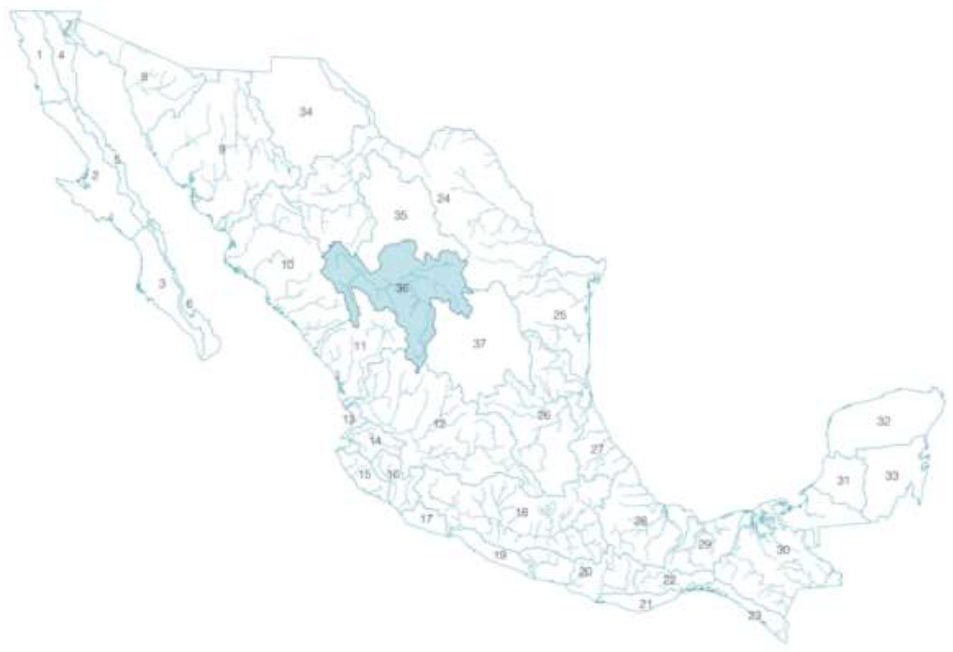
Figure 2.
Basins that conform the hydrological region 36 Nazas-Aguanaval. Graphic by the authors, based on geospatial data from INEGI. Hydrographic network scale 1:50000 edition 2.
Figure 2.
Basins that conform the hydrological region 36 Nazas-Aguanaval. Graphic by the authors, based on geospatial data from INEGI. Hydrographic network scale 1:50000 edition 2.
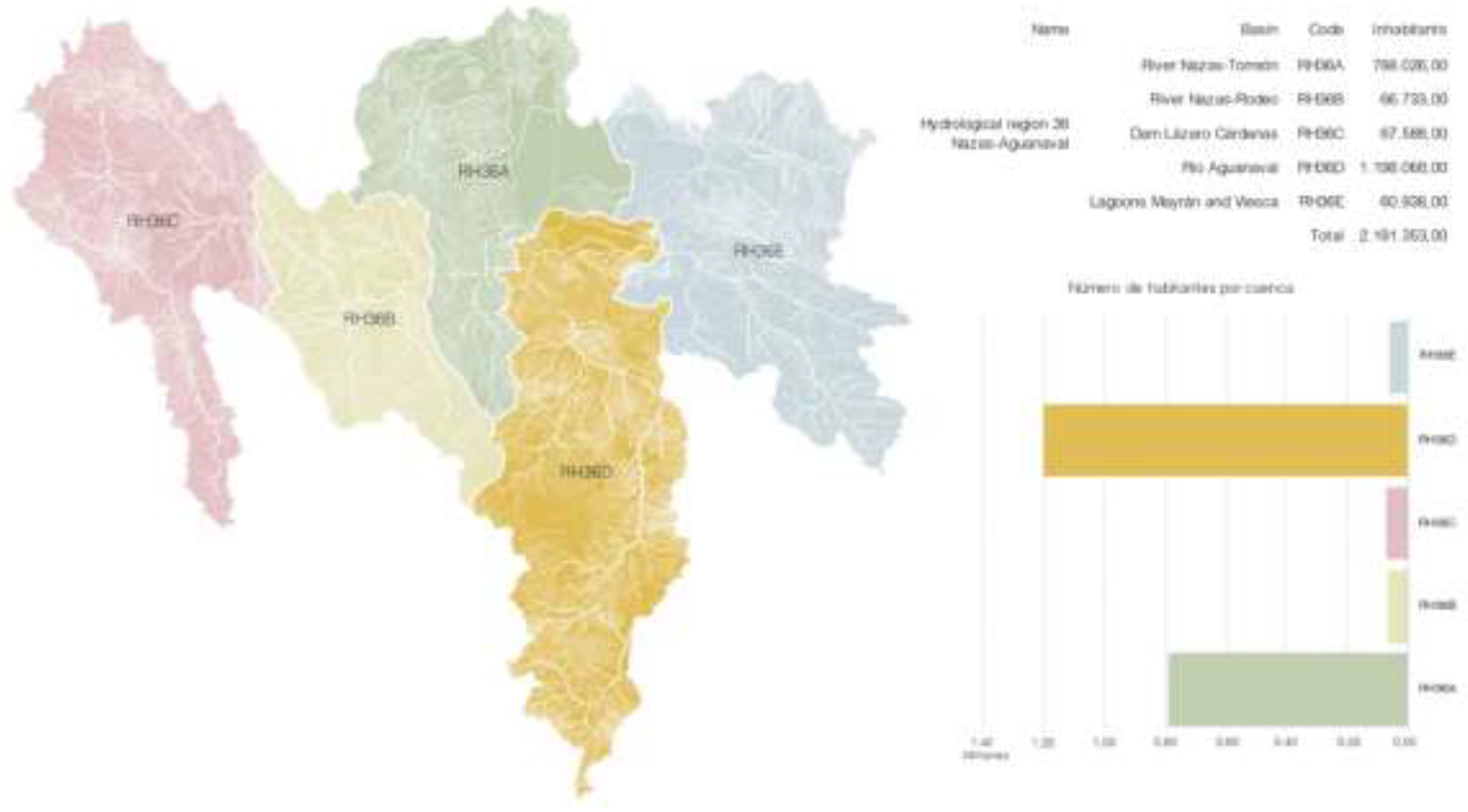
Figure 3.
Sub-basins of the hydrological region 36 Nazas-Aguanaval. Graphic by the authors, based on geospatial data from INEGI. Hydrographic network scale 1:50000 edition 2 and Geostatistical Framework 2020.
Figure 3.
Sub-basins of the hydrological region 36 Nazas-Aguanaval. Graphic by the authors, based on geospatial data from INEGI. Hydrographic network scale 1:50000 edition 2 and Geostatistical Framework 2020.
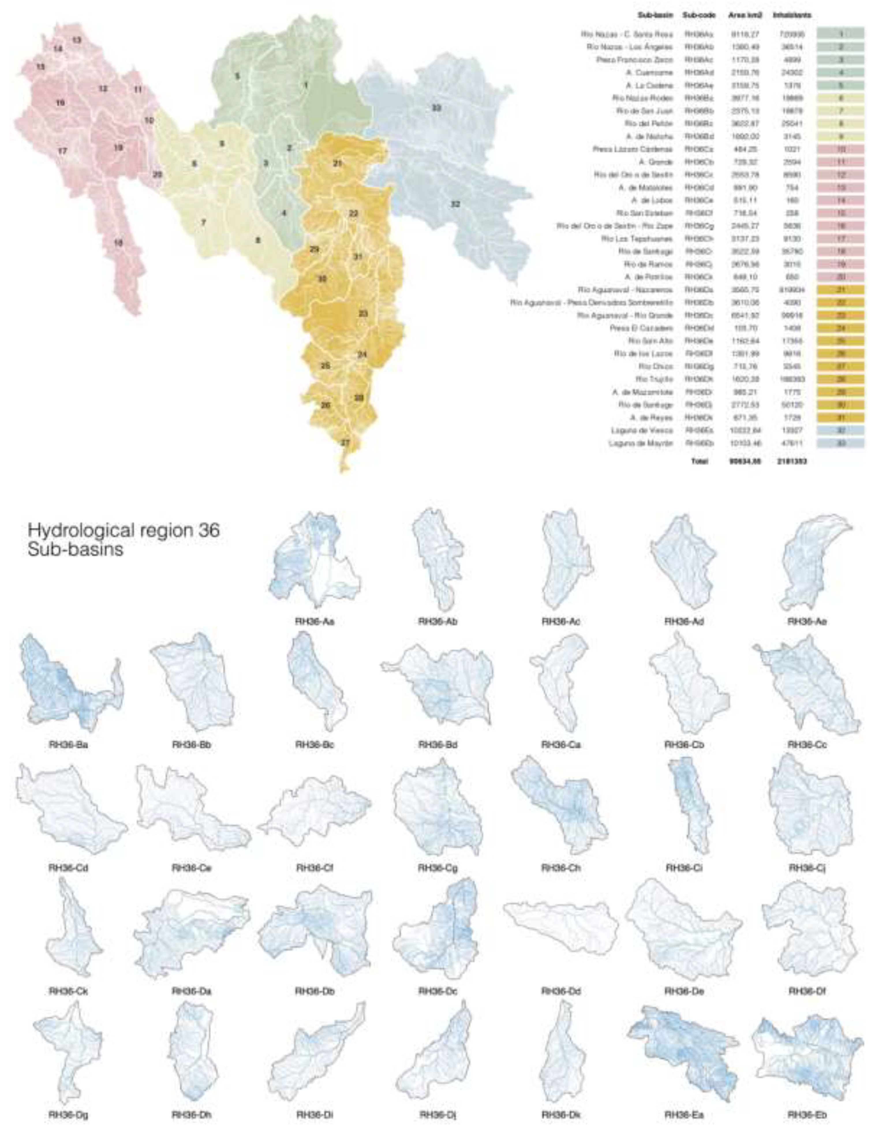
Figure 4.
Hierarchical structure of the hydrographic basin. Water basin C (Lázaro Cárdenas Dam), Sub-basin Cj (De Ramos River), General Escobedo Micro-basin. Graphic by the authors, based on geospatial data from INEGI. Concept from: (López & Patrón, 2013: 11).
Figure 4.
Hierarchical structure of the hydrographic basin. Water basin C (Lázaro Cárdenas Dam), Sub-basin Cj (De Ramos River), General Escobedo Micro-basin. Graphic by the authors, based on geospatial data from INEGI. Concept from: (López & Patrón, 2013: 11).
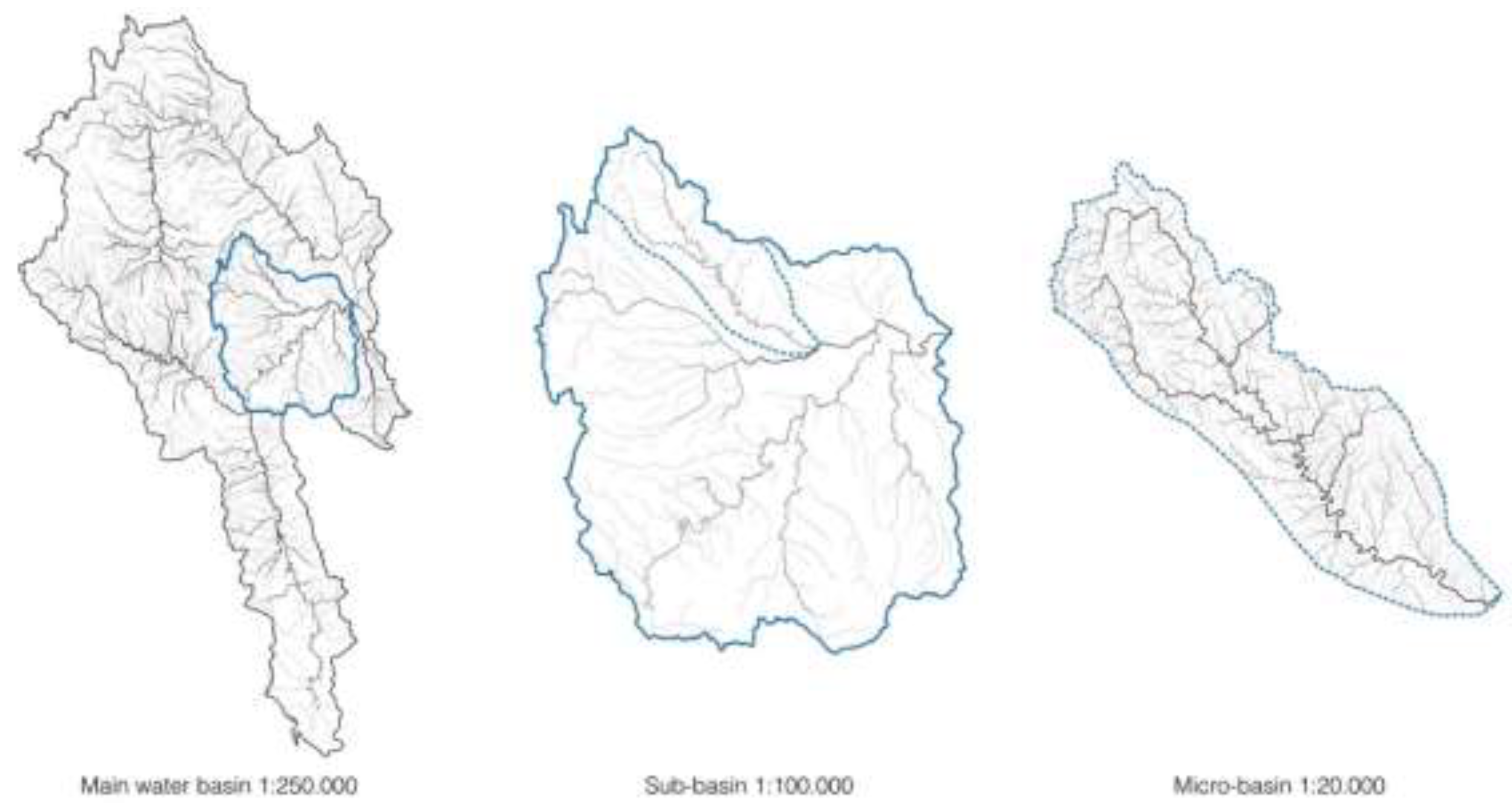
Figure 5.
Schematic model of an urban basin to exemplify the disruption of the hydrographic network. Graphic by the authors.
Figure 5.
Schematic model of an urban basin to exemplify the disruption of the hydrographic network. Graphic by the authors.
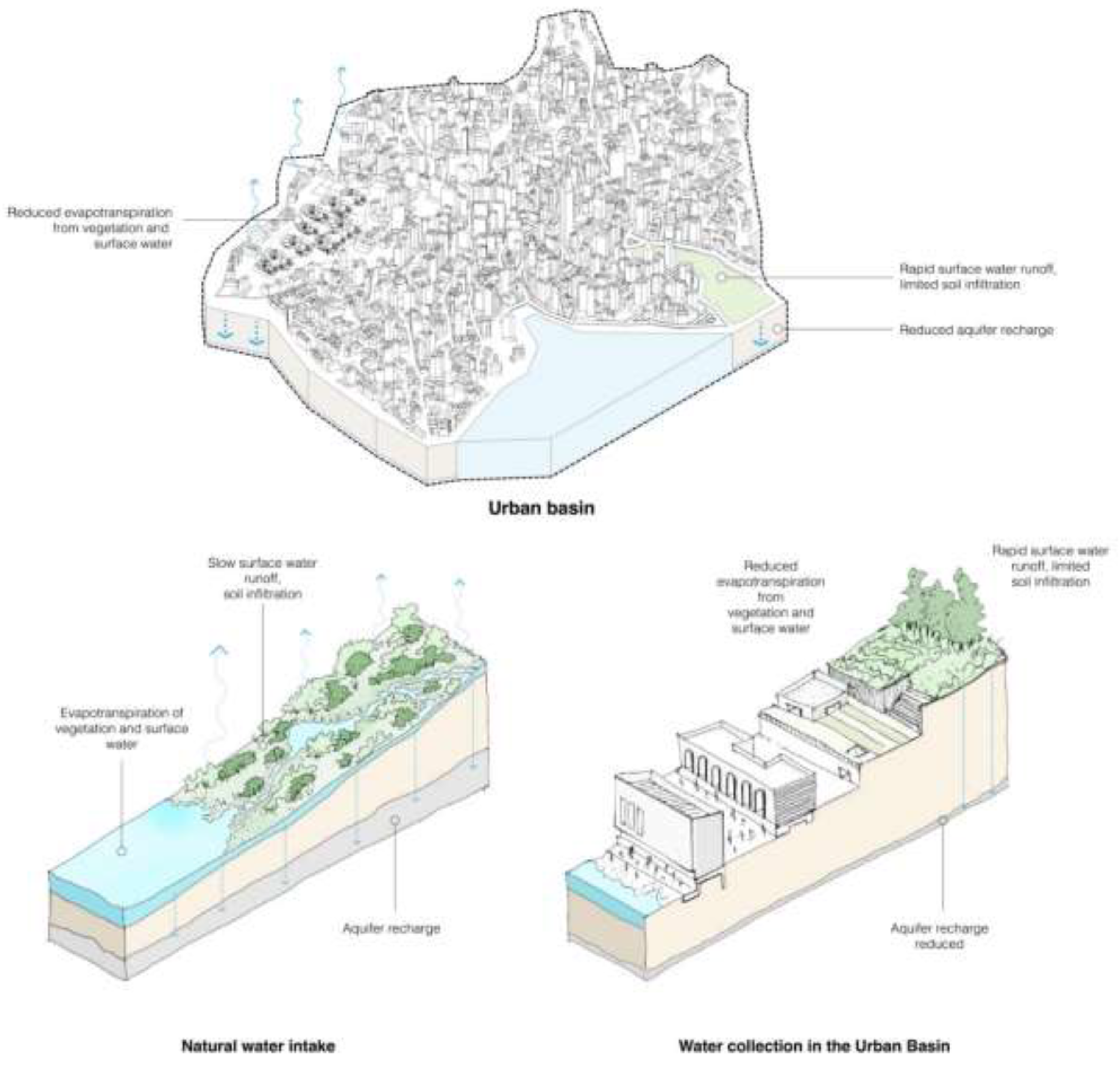
Figure 6.
DEM (Digital Elevation Model) image of the hydrological region 36 in the Lambert Conformal Conical projection. Graphic by the authors: based on geospatial data from INEGI and edited from mentioned sources.
Figure 6.
DEM (Digital Elevation Model) image of the hydrological region 36 in the Lambert Conformal Conical projection. Graphic by the authors: based on geospatial data from INEGI and edited from mentioned sources.
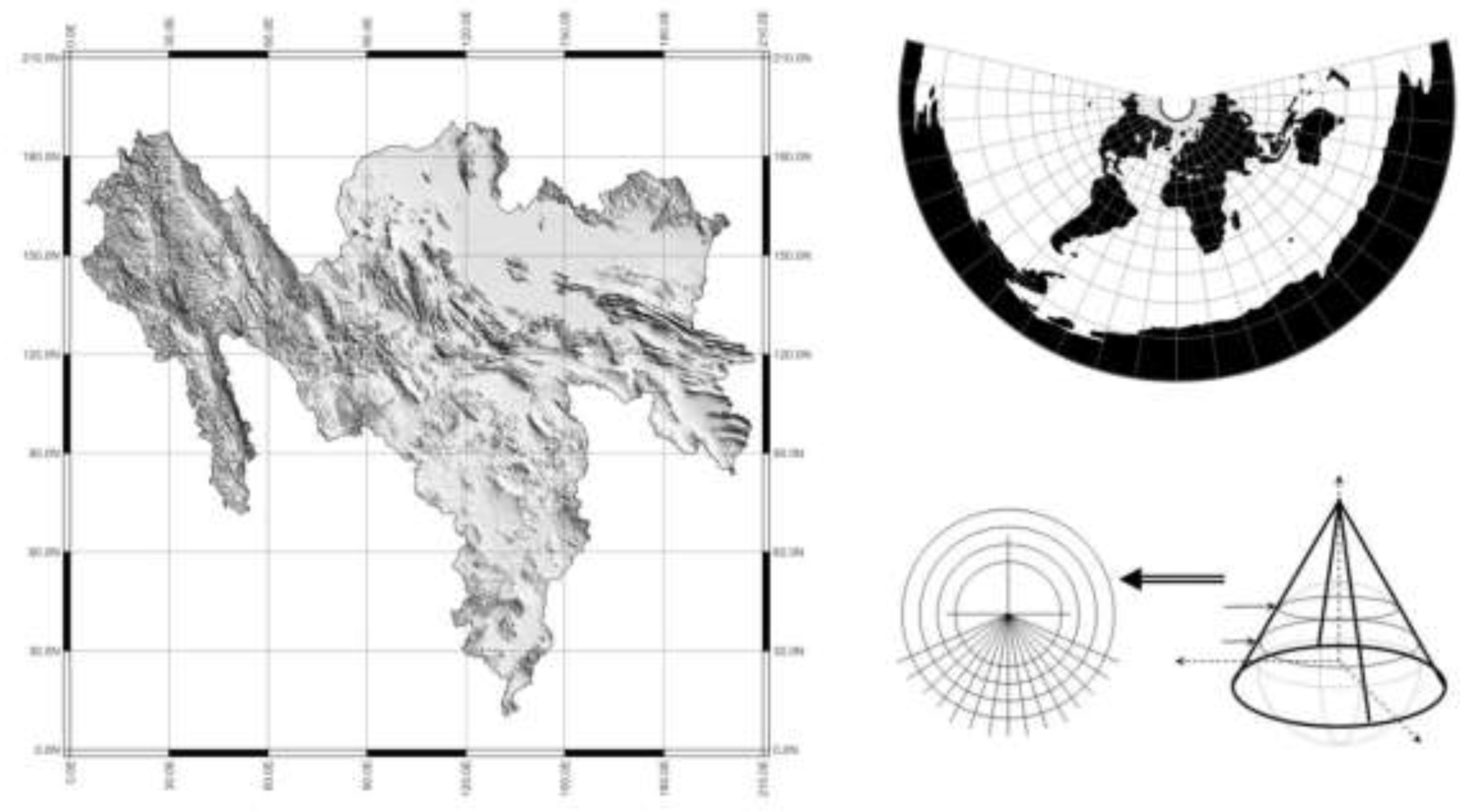
Figure 7.
Strahler order assignment. Graphic by the authors.
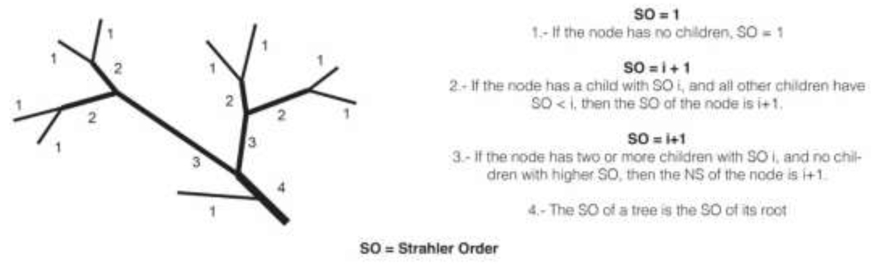
Figure 8.
Strahler number Interpretation in the RH36De sub-basin. Belonging to basin D: Aguanaval River. Graphic by the authors; Geospatial data from the INEGI geostatistical framework.
Figure 8.
Strahler number Interpretation in the RH36De sub-basin. Belonging to basin D: Aguanaval River. Graphic by the authors; Geospatial data from the INEGI geostatistical framework.
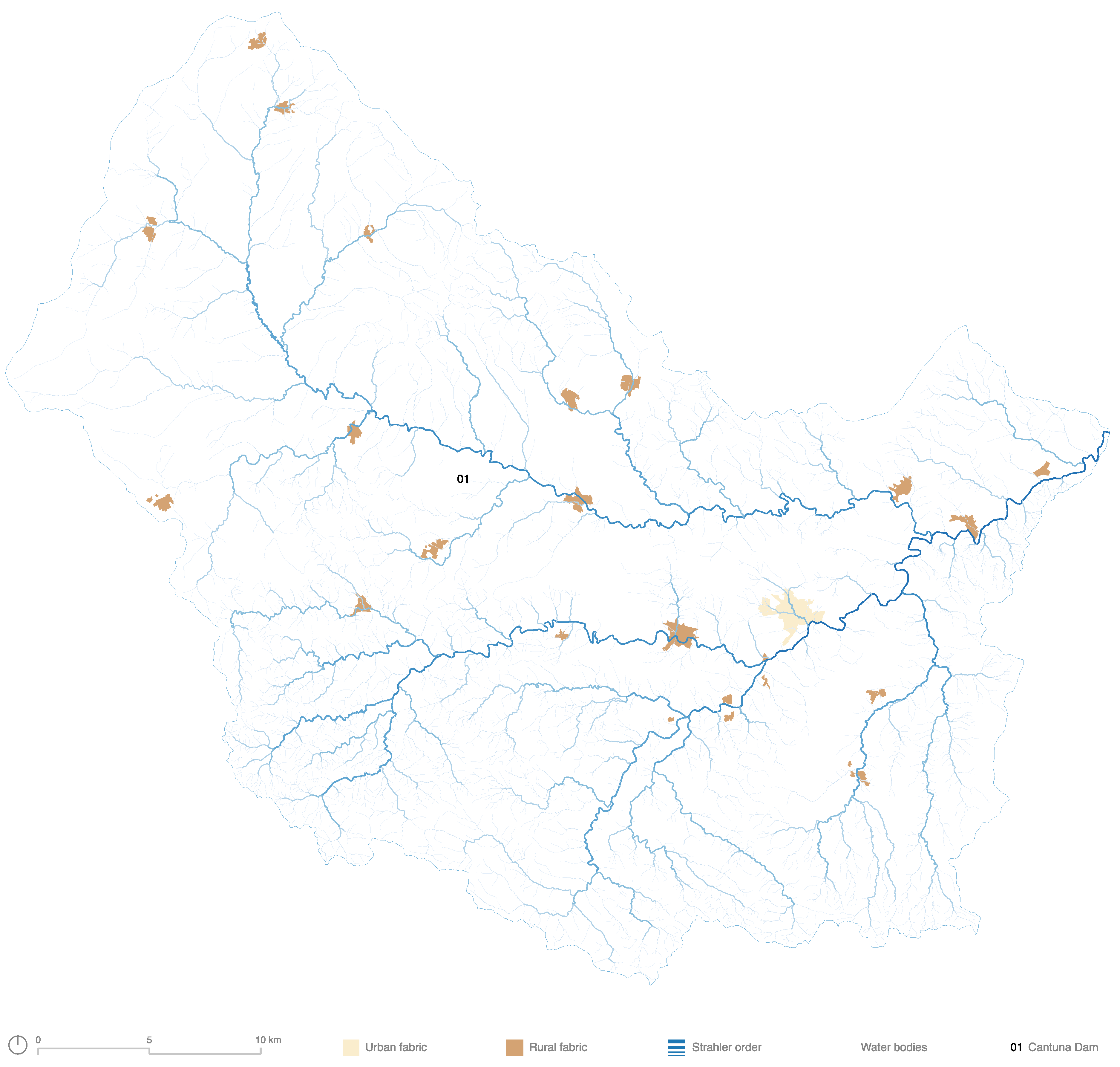
Figure 9.
Sub-basin RH36De. Anthropized percentage and categories of agroproductive surfaces. Graphic by the authors. Incorporation of geospatial information from the INEGI, SINA y RAN.
Figure 9.
Sub-basin RH36De. Anthropized percentage and categories of agroproductive surfaces. Graphic by the authors. Incorporation of geospatial information from the INEGI, SINA y RAN.
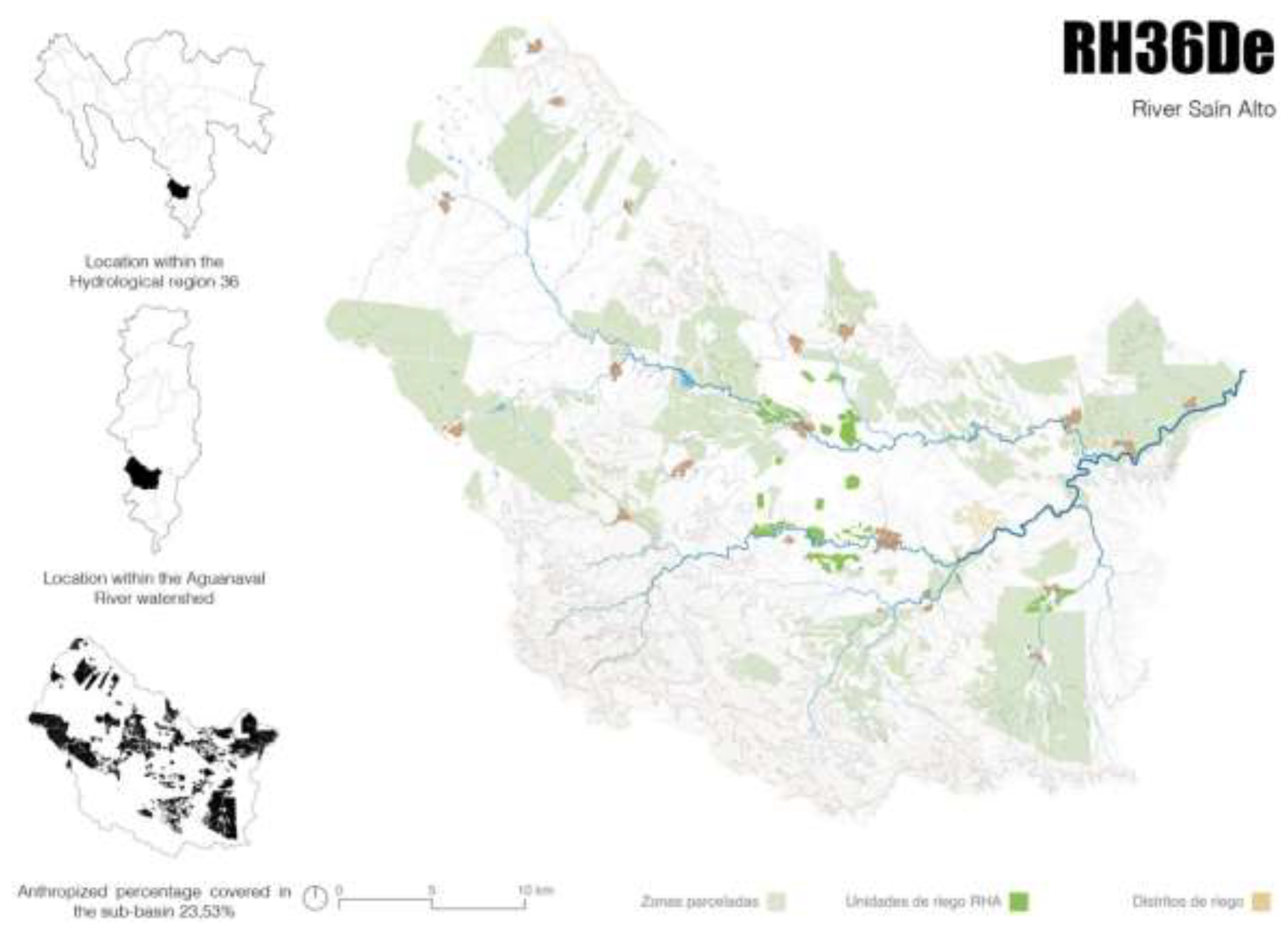
Figure 10.
Sub-basin RH36Cc sub-basin River del Oro or River Sextin on 3D. Main settlements and shorter distance to hydric axis. Graphic by the authors: generation from DEM file and photoshop complement 3d map generator.
Figure 10.
Sub-basin RH36Cc sub-basin River del Oro or River Sextin on 3D. Main settlements and shorter distance to hydric axis. Graphic by the authors: generation from DEM file and photoshop complement 3d map generator.
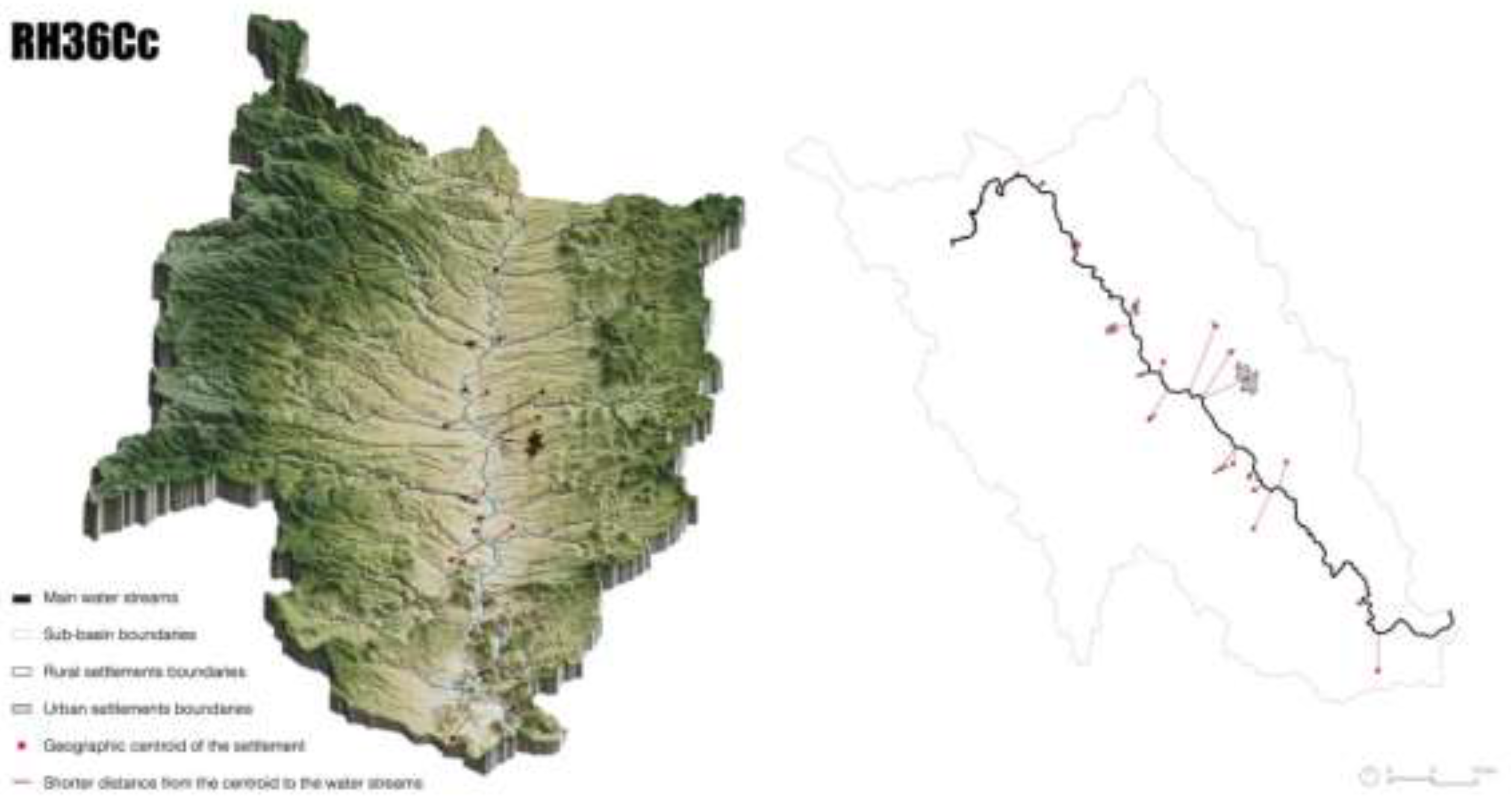
Figure 11.
Sub-basin RH36Ba River Nazas-Rodeo. Interaction between the water network and road infrastructures. Conflict zones. Graphic by the authors. Geospatial data INEGI.
Figure 11.
Sub-basin RH36Ba River Nazas-Rodeo. Interaction between the water network and road infrastructures. Conflict zones. Graphic by the authors. Geospatial data INEGI.
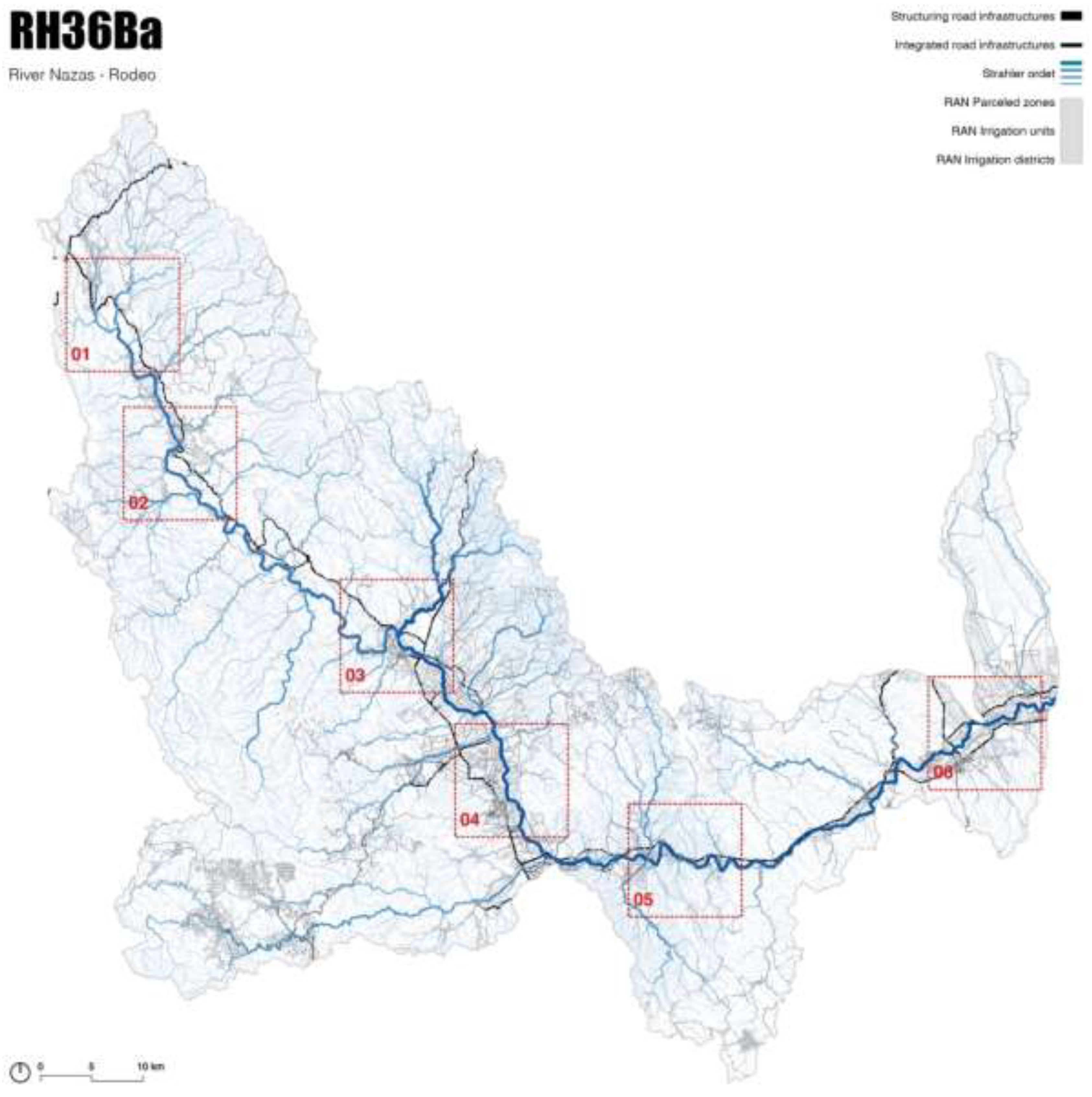
Figure 12.
Main areas of conflict between the road infrastructure network and the water network in the sub-basin RH36Ba. Graphic by the authors. Geospatial data INEGI.
Figure 12.
Main areas of conflict between the road infrastructure network and the water network in the sub-basin RH36Ba. Graphic by the authors. Geospatial data INEGI.
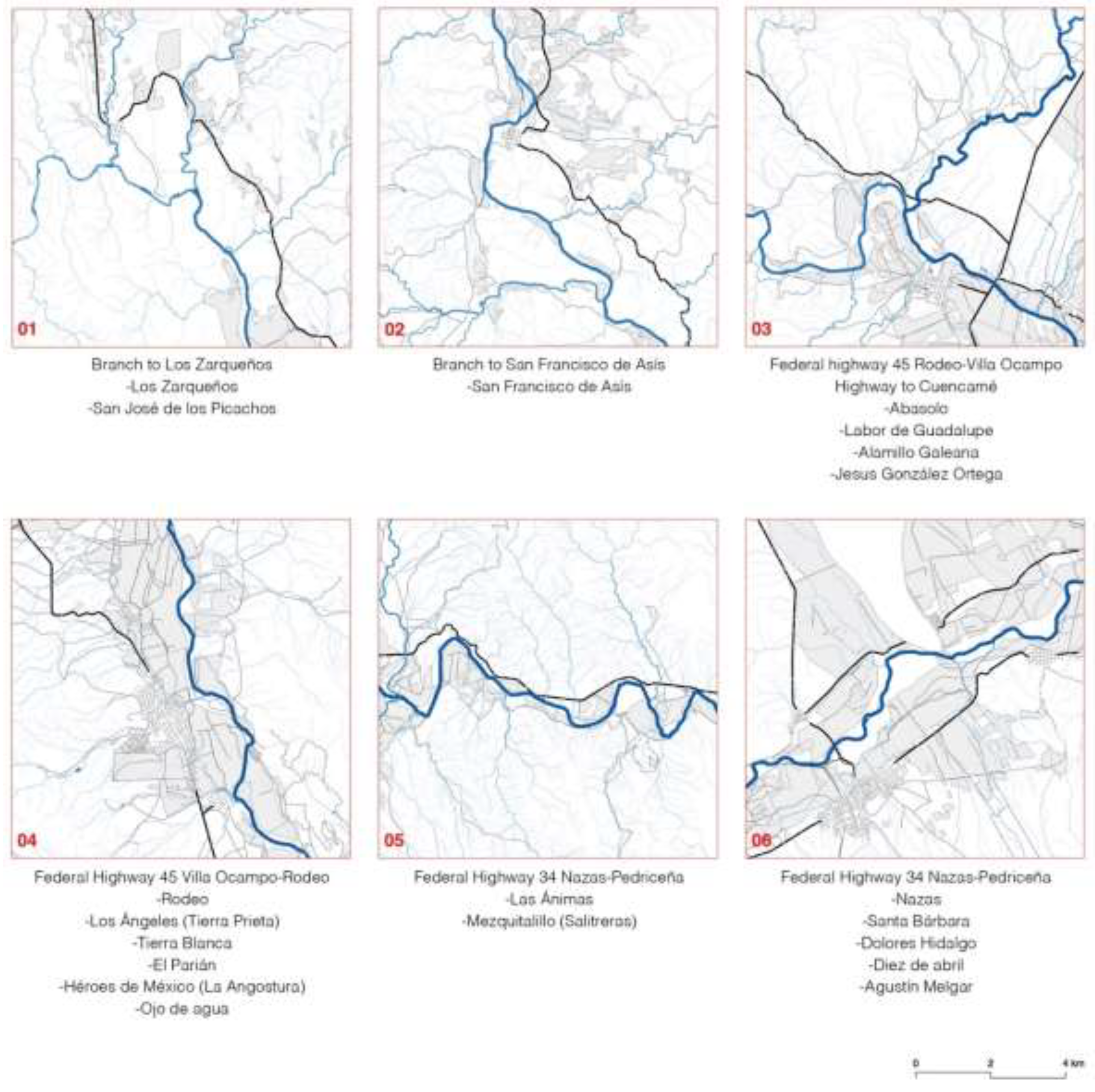
Figure 13.
Building footprint vectorization process within QGIS. Graphic by the authors.
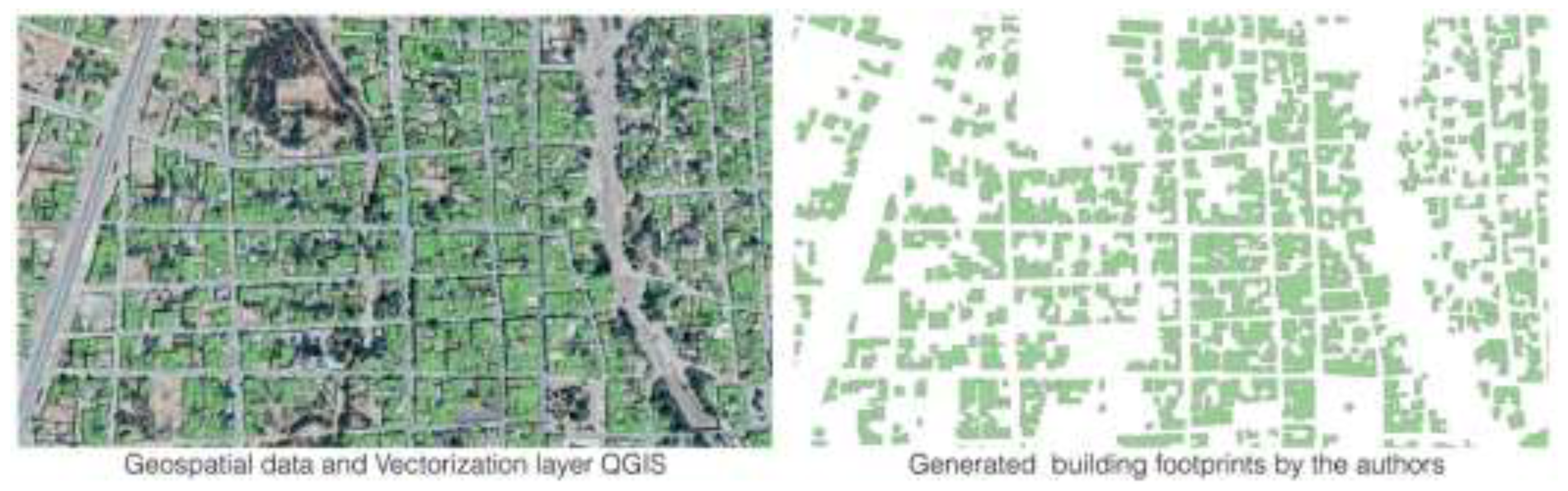
Figure 14.
Sub-basin RH36Bb San Juan River. Settlement system and hydrographic network. Graphic by the authors. Supervised vectorization in GIS from satellite images.
Figure 14.
Sub-basin RH36Bb San Juan River. Settlement system and hydrographic network. Graphic by the authors. Supervised vectorization in GIS from satellite images.
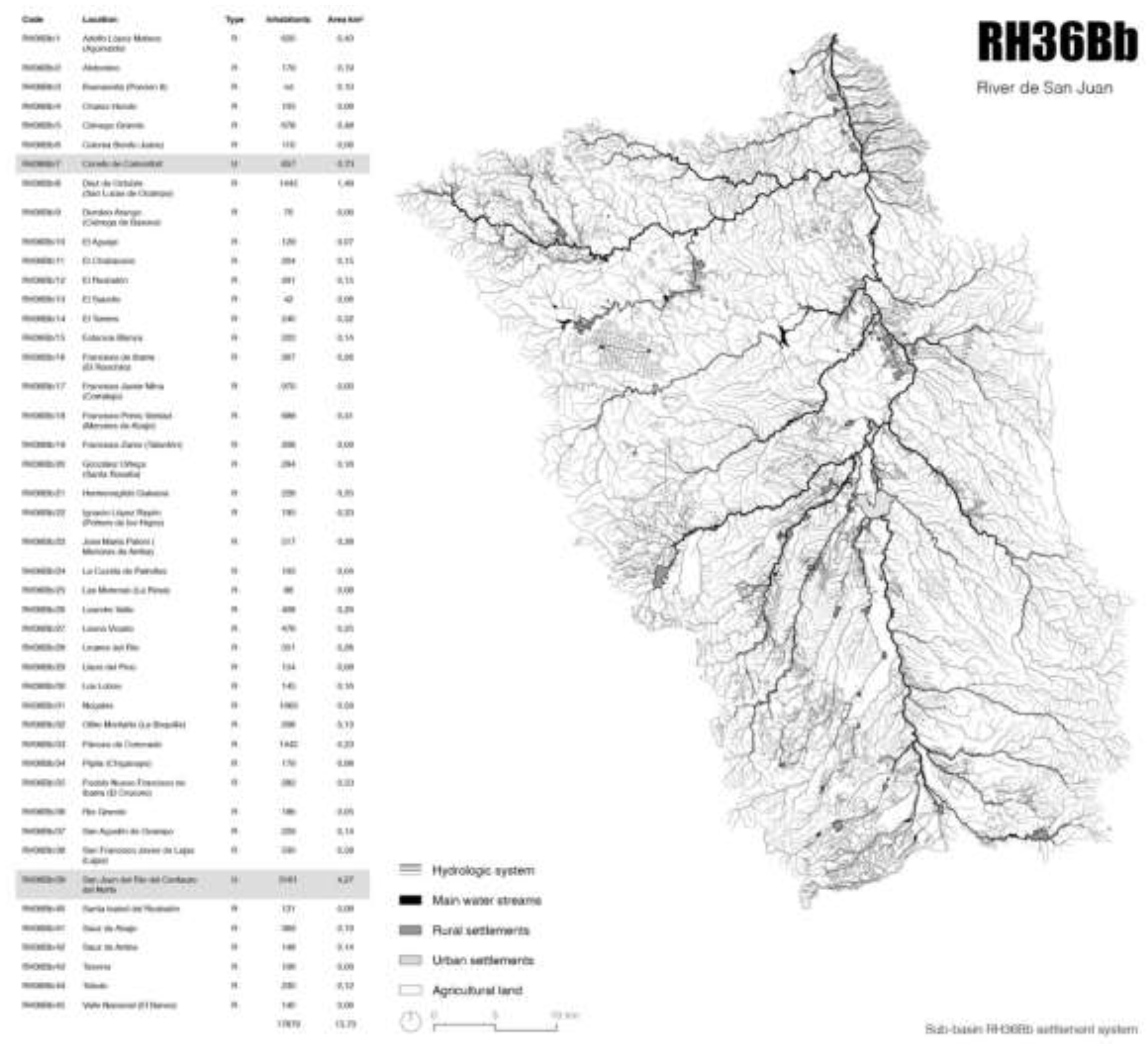
Figure 15.
Generation of building information. Sub-basin RH36Bb San Juan River. Graphic by the authors. Supervised vectorization in GIS from satellite images.
Figure 15.
Generation of building information. Sub-basin RH36Bb San Juan River. Graphic by the authors. Supervised vectorization in GIS from satellite images.
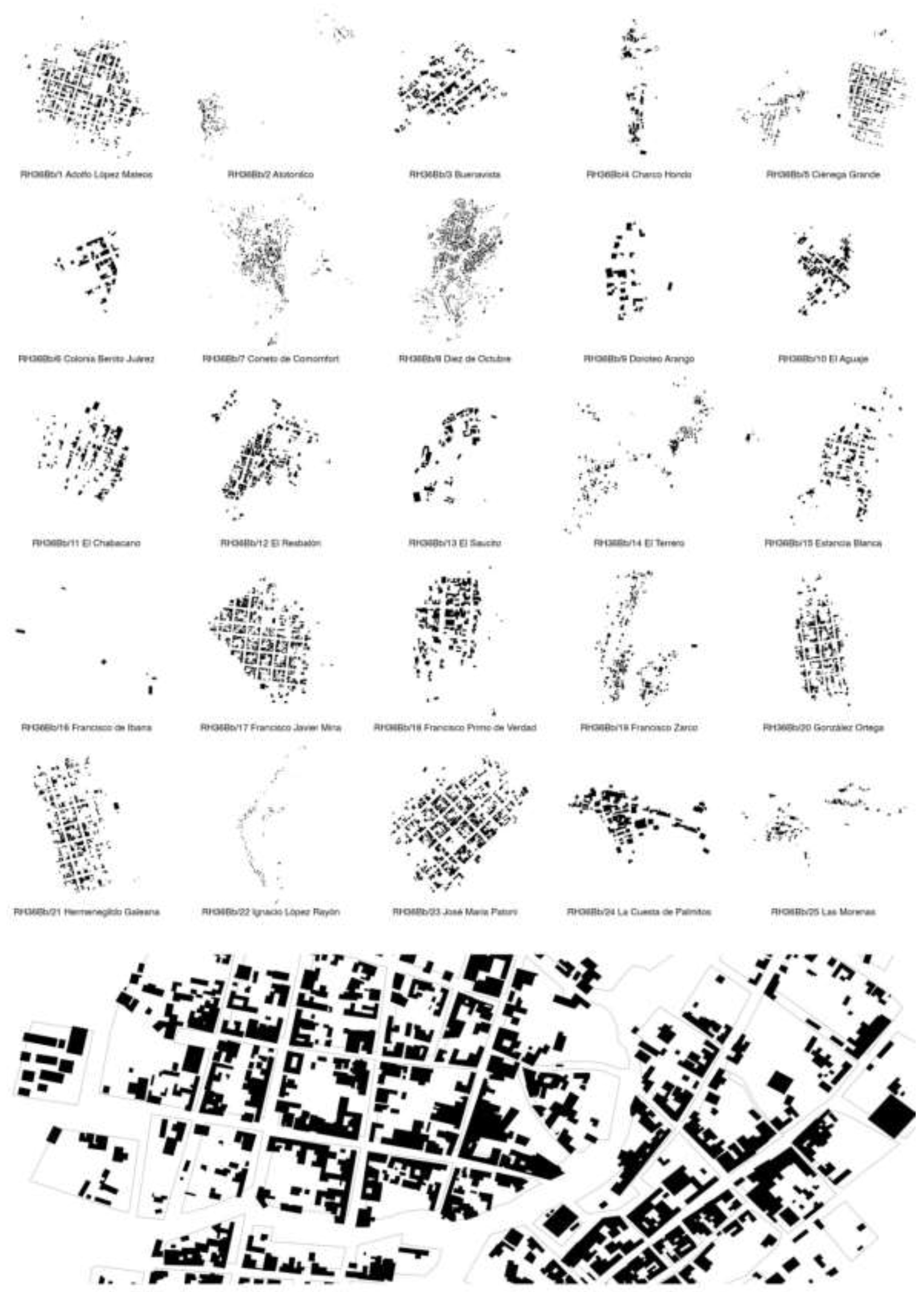
Figure 16.
Sub-basin RH36Ci River de Santiago. Main settlements and agroproductive surfaces. Graphic by the authors. Geospatial data from INEGI, RAN y own vectorization on SIG.
Figure 16.
Sub-basin RH36Ci River de Santiago. Main settlements and agroproductive surfaces. Graphic by the authors. Geospatial data from INEGI, RAN y own vectorization on SIG.
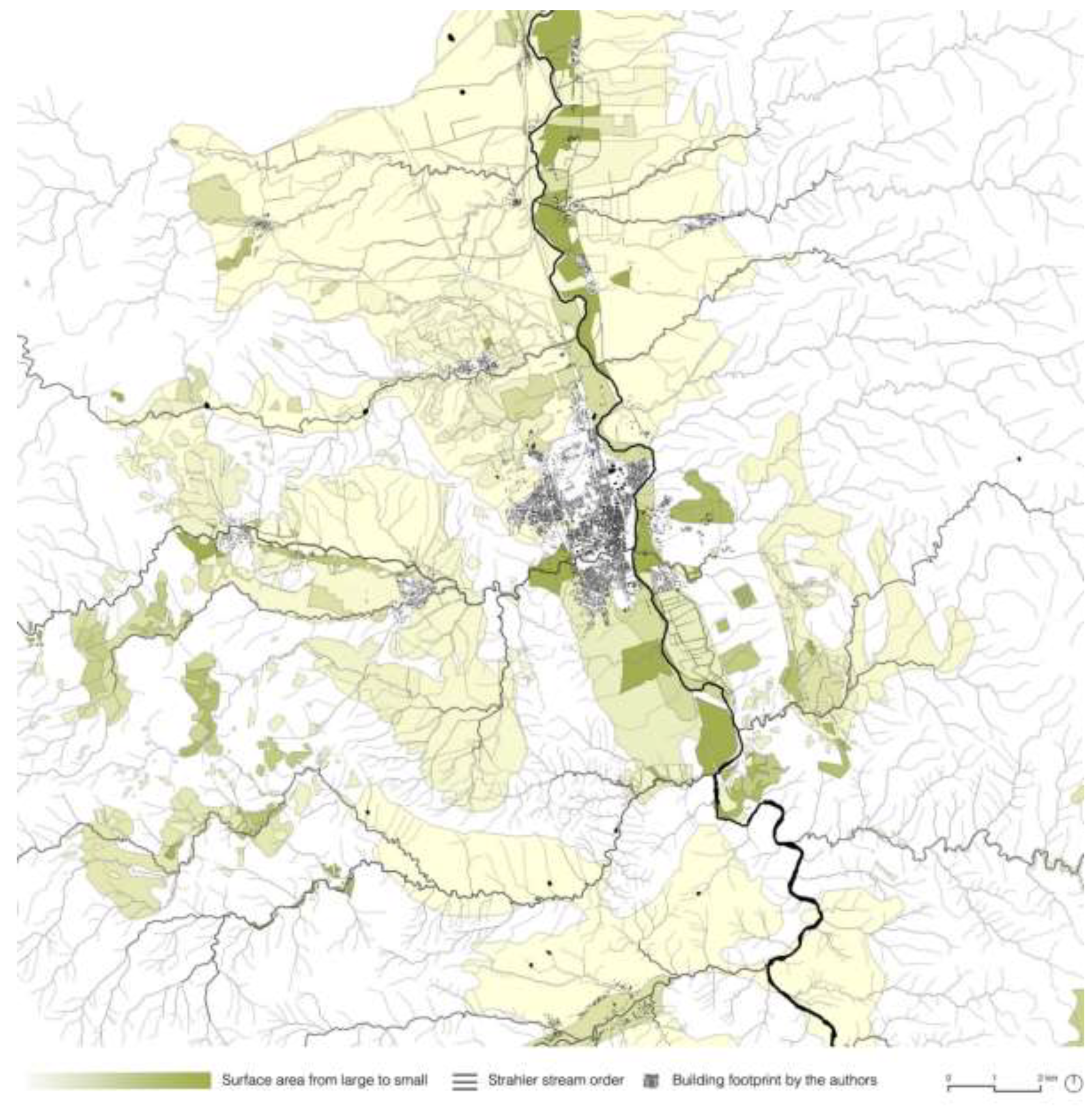
Figure 17.
Sub-basin RH36Dc Aguanaval River. Main towns and agro-productive areas. Graphic by the authors, from geospatial data INEGI, and RAN vectorization in SIG.
Figure 17.
Sub-basin RH36Dc Aguanaval River. Main towns and agro-productive areas. Graphic by the authors, from geospatial data INEGI, and RAN vectorization in SIG.
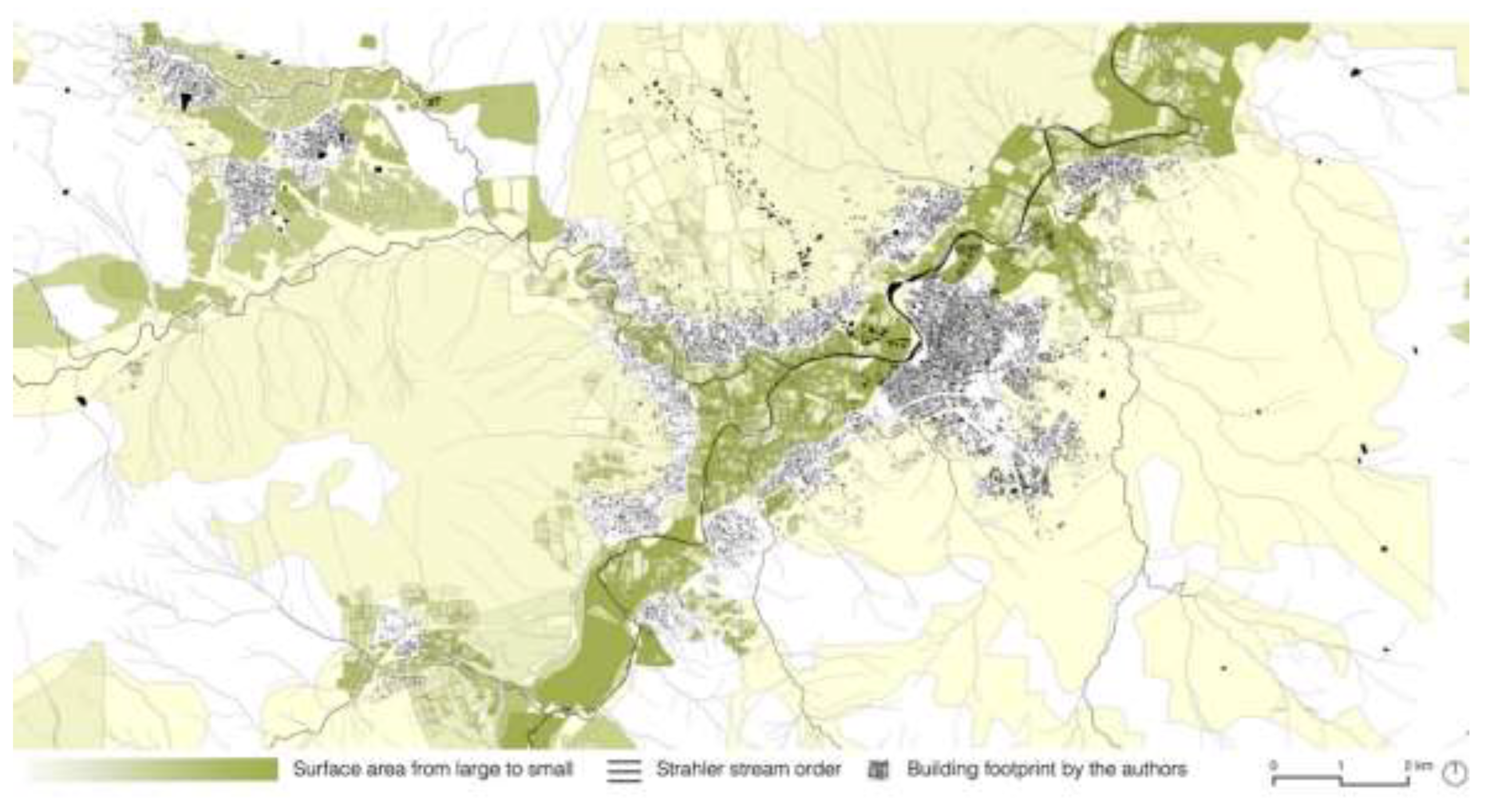
Figure 18.
Process in QGIS for the integration of the water footprint in the building layer. RH36Ad.4 Cuencamé of Ceniceros inhabitants. Graphic by the authors.
Figure 18.
Process in QGIS for the integration of the water footprint in the building layer. RH36Ad.4 Cuencamé of Ceniceros inhabitants. Graphic by the authors.
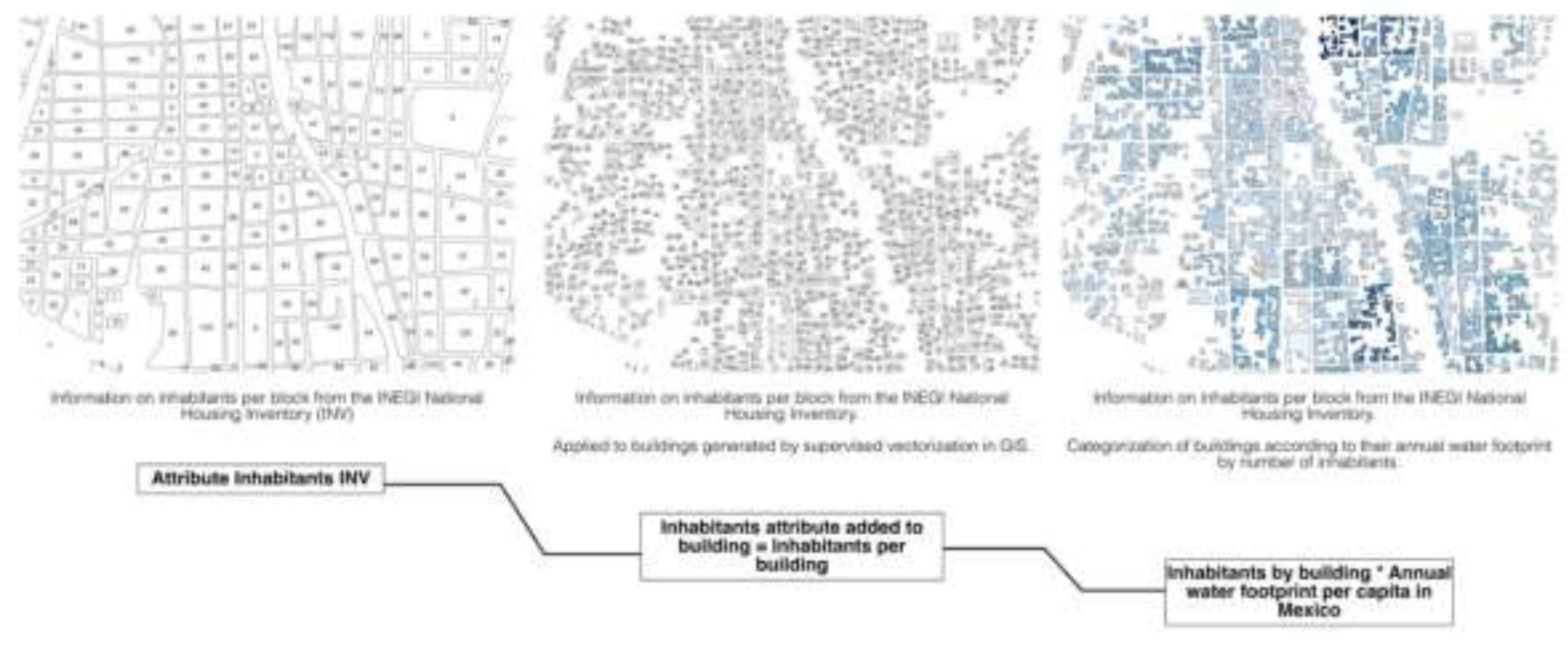
Figure 19.
RH36Ad.4 Cuencamé de Ceniceros urban community. Annual water footprint m3 inhabitants/block. Graphic by the authors.
Figure 19.
RH36Ad.4 Cuencamé de Ceniceros urban community. Annual water footprint m3 inhabitants/block. Graphic by the authors.
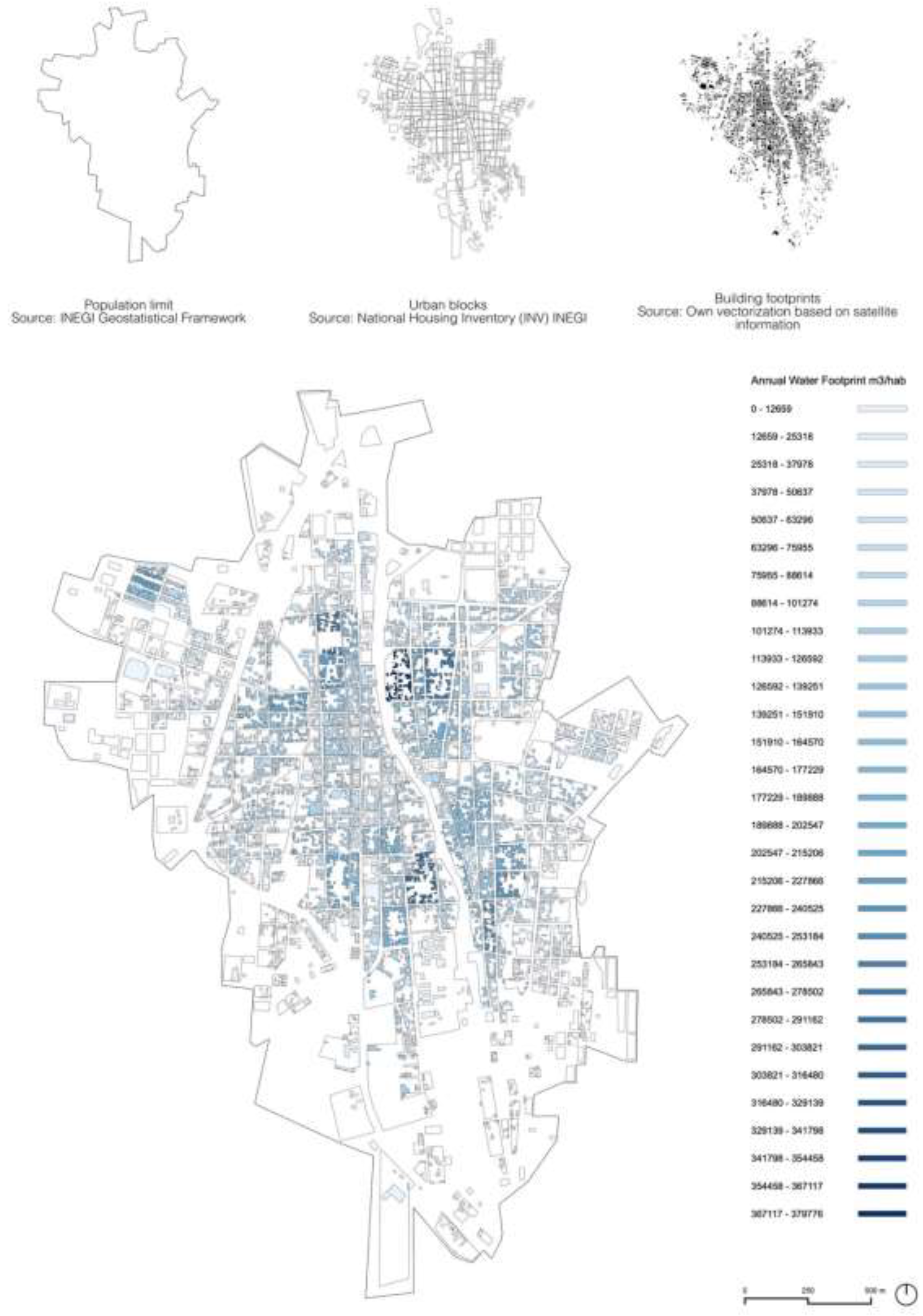
Figure 20.
Buildings facing the Sacramento canal in the city of Gomez Palacio. Sub-basin RH36Aa. Graphic by the authors.
Figure 20.
Buildings facing the Sacramento canal in the city of Gomez Palacio. Sub-basin RH36Aa. Graphic by the authors.
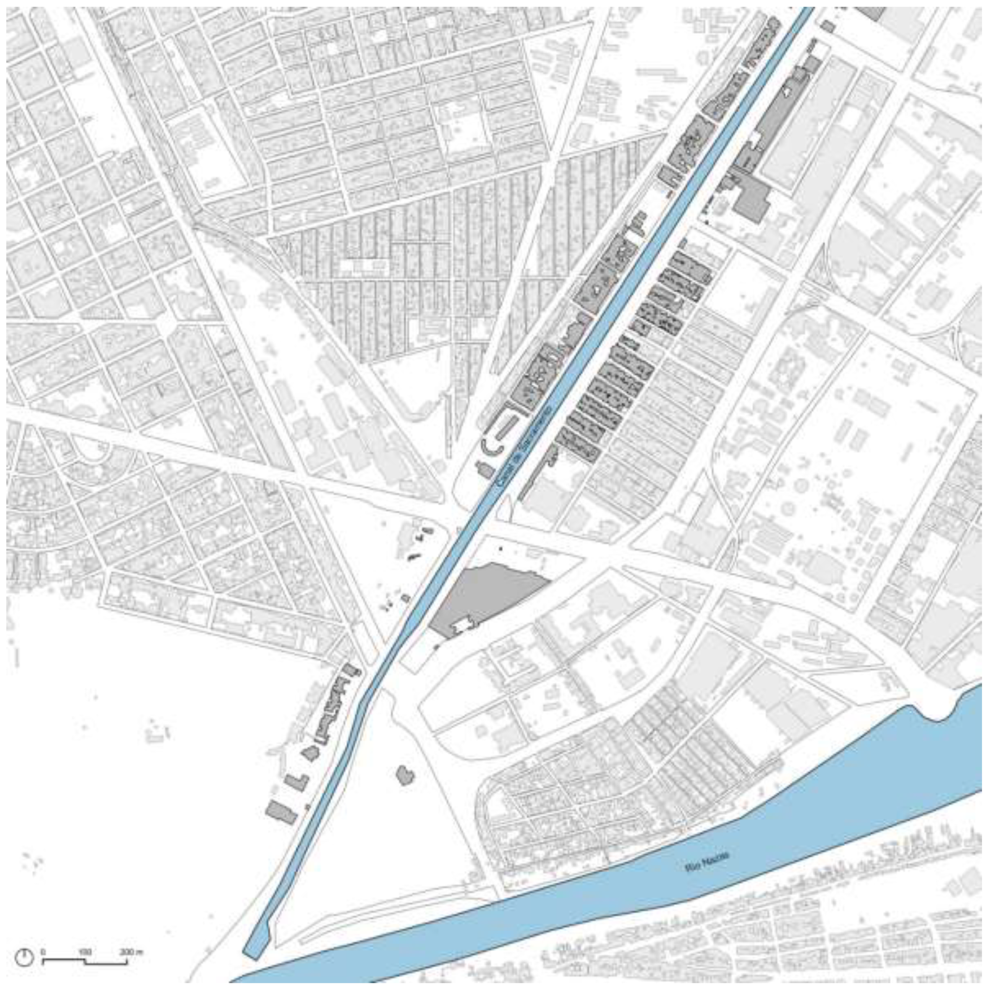
Figure 21.
Facade fronts facing the Sacramento Canal in the city of Gomez Palacio Durango. Photography: Google streetview.
Figure 21.
Facade fronts facing the Sacramento Canal in the city of Gomez Palacio Durango. Photography: Google streetview.
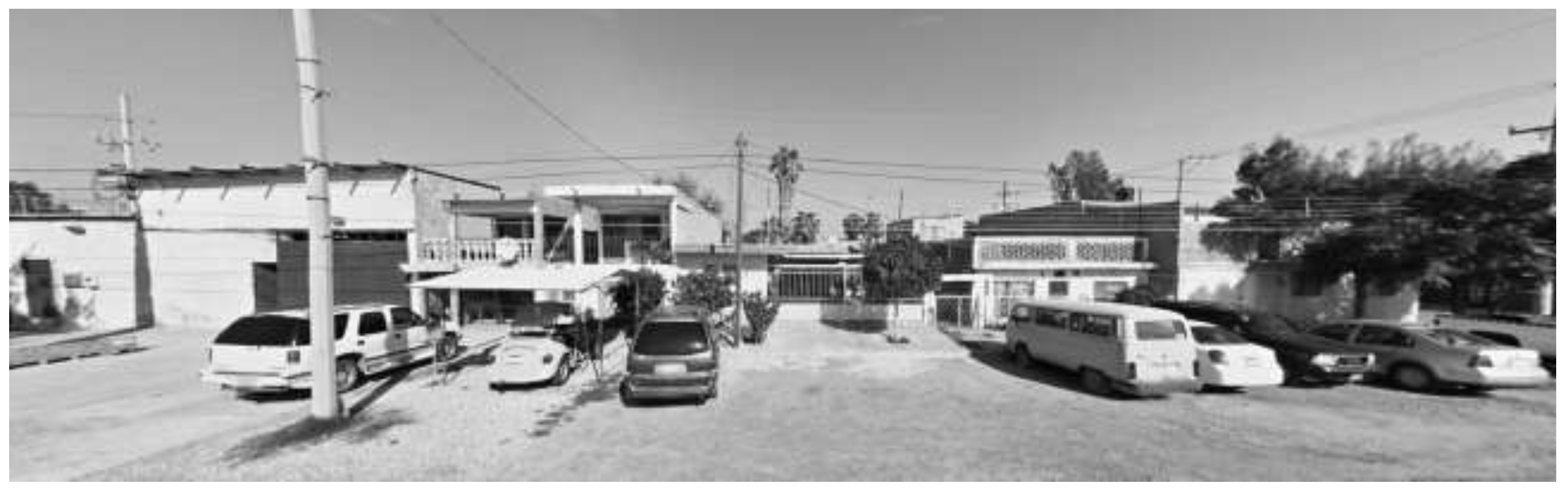
Figure 22.
Sacramento Canal. Detail of the crossings and buildings in front of the artificial watercourse. Photography by the authors.
Figure 22.
Sacramento Canal. Detail of the crossings and buildings in front of the artificial watercourse. Photography by the authors.
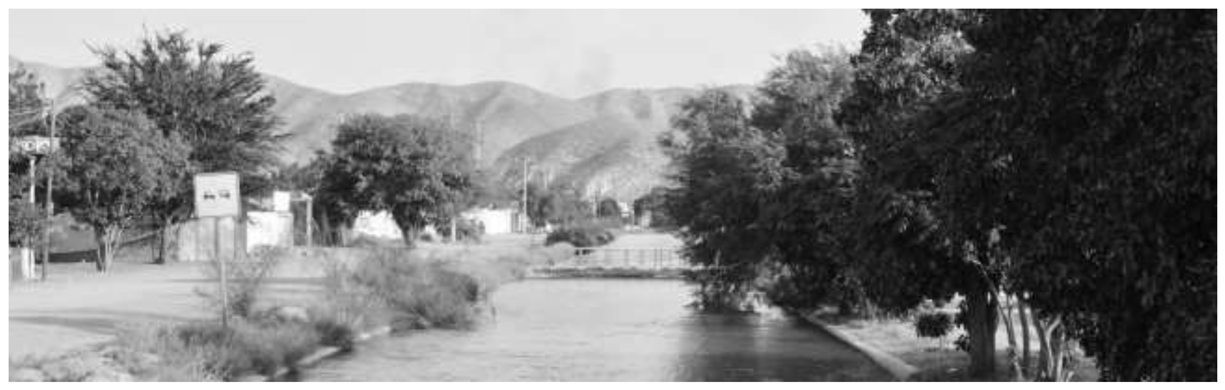
Figure 23.
Schematic section of the current state of the Sacramento canal. Graphic by the authors.
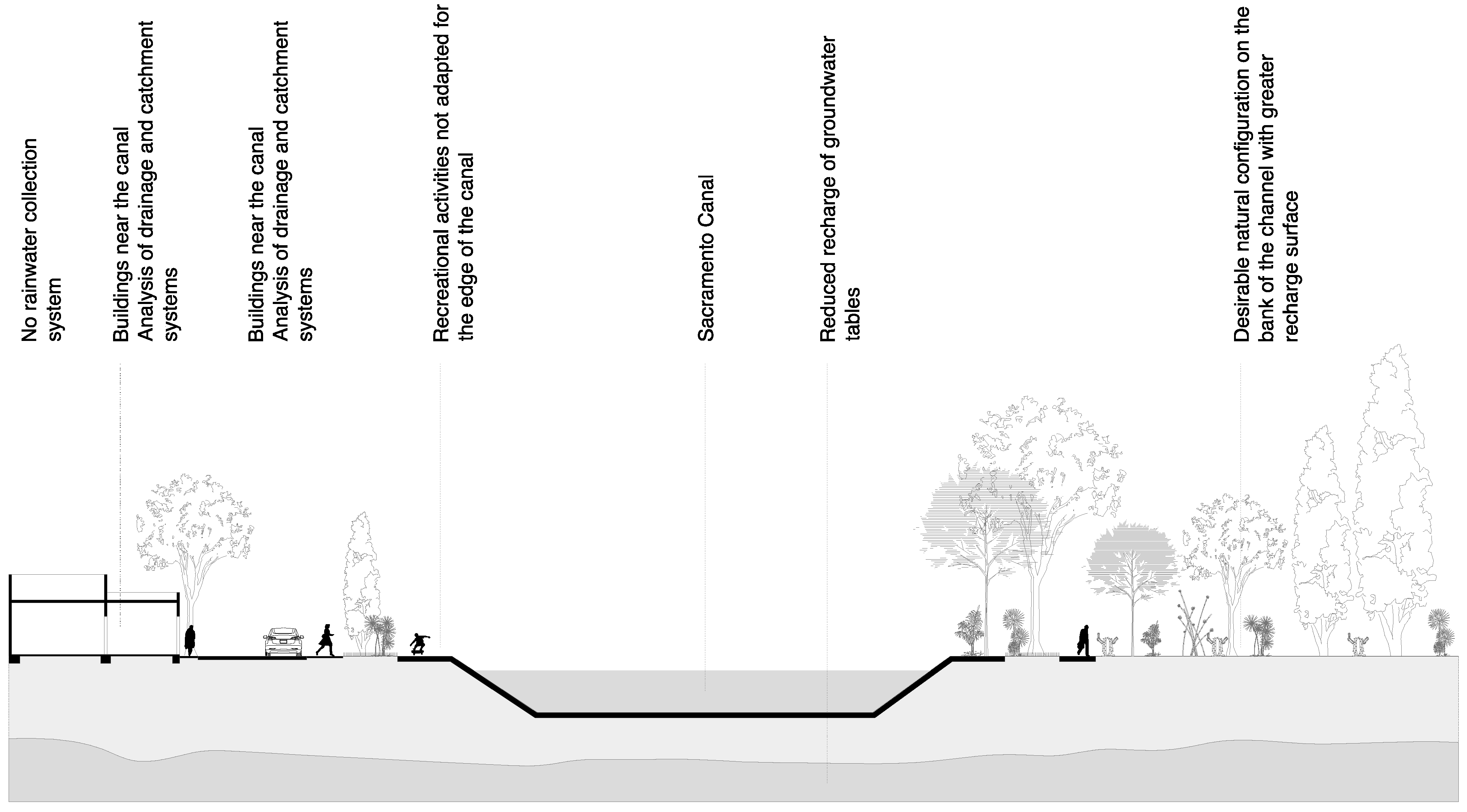
Figure 24.
Calculation of the water footprint by product. Source: Hoekstra [11].
Figure 24.
Calculation of the water footprint by product. Source: Hoekstra [11].
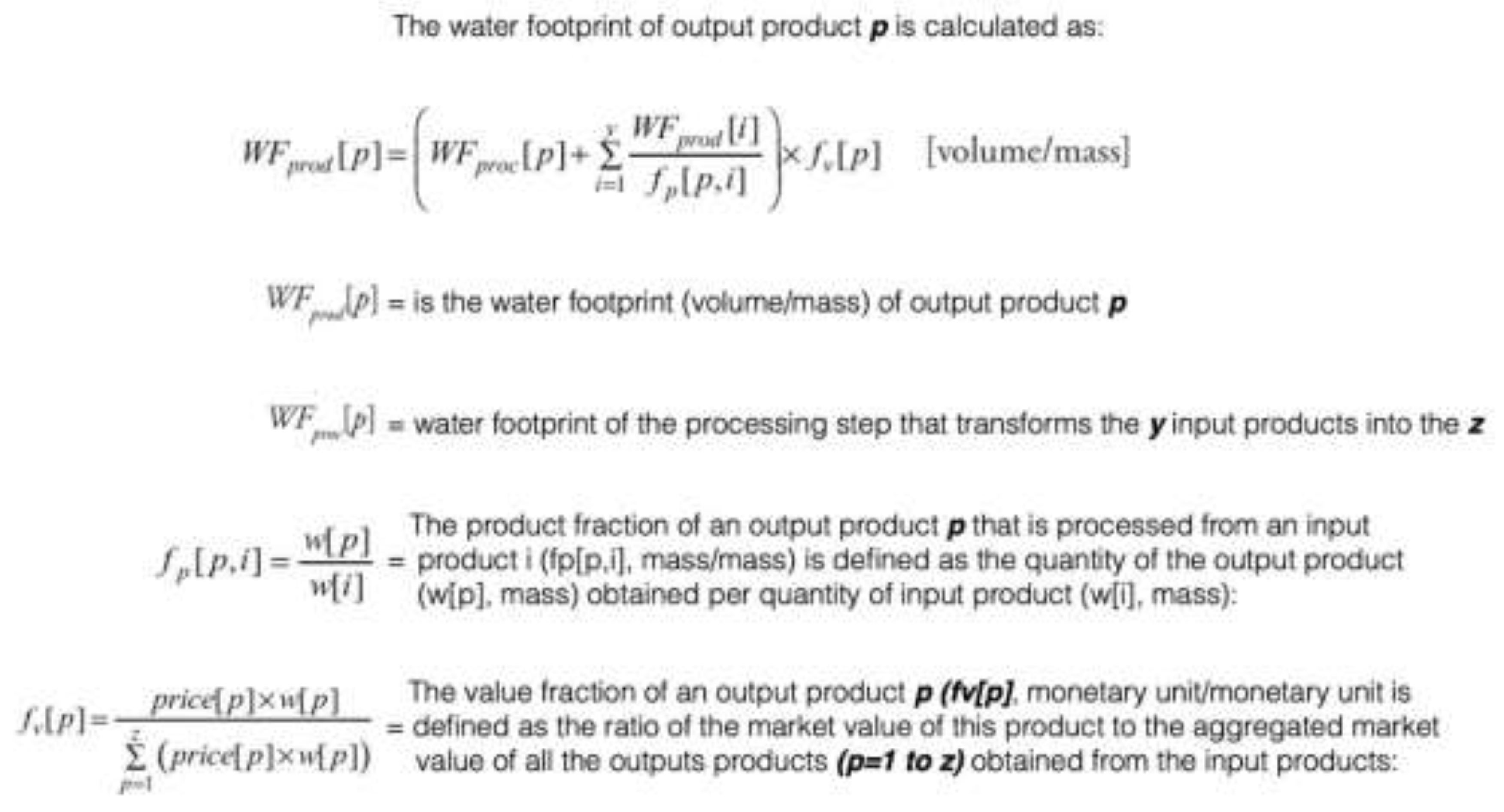
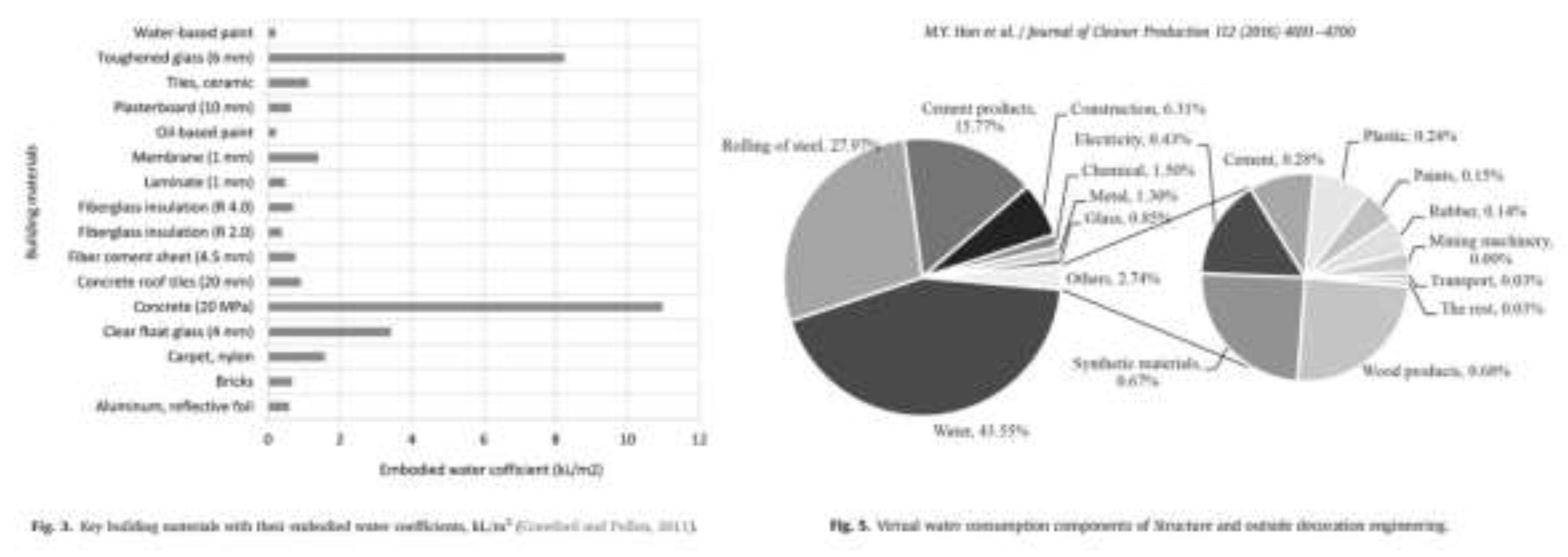
Figure 26.
Traditional construction system hydrological region 36. Construction materials with high water consumption for their production. Graphic by the authors.
Figure 26.
Traditional construction system hydrological region 36. Construction materials with high water consumption for their production. Graphic by the authors.
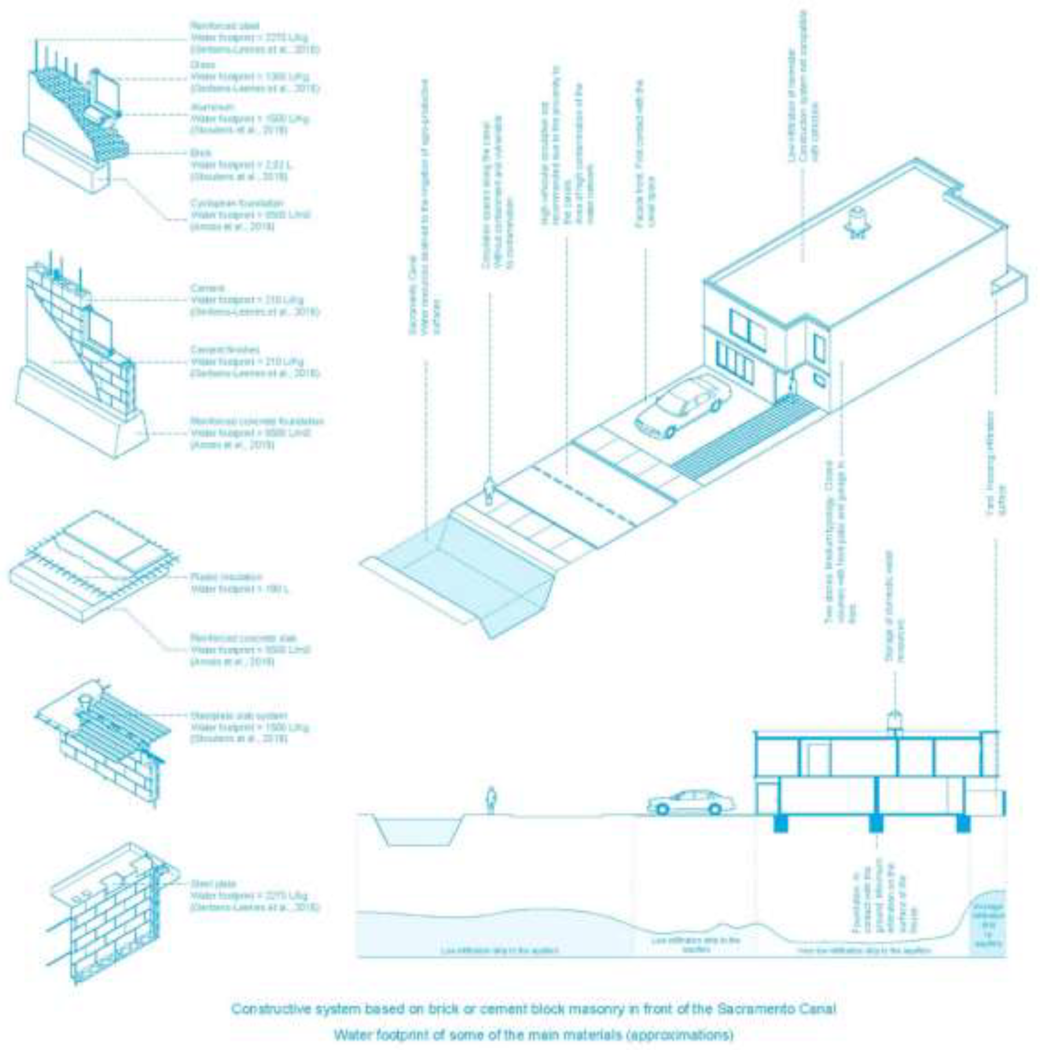

Table 1.
The 37 hydrological regions identified by the National Water Commission. In blue the RH36 object of this study. Graphic by the authors: based on geospatial data from the National Information System (SINA).
Table 1.
The 37 hydrological regions identified by the National Water Commission. In blue the RH36 object of this study. Graphic by the authors: based on geospatial data from the National Information System (SINA).
| No. | Hydrological Region | Normal precipitation 1991-2020 (mm) | Average internal surface natural runoff (hm3/año) | Imports (+) o Exports (-) from other countries (hm3/año) | Average total surface natural runoff (hm3/año) | Number of basins | Area (km2) |
|---|---|---|---|---|---|---|---|
| 1 | B.C. Noroeste | 195 | 359 | 17 | 376 | 16 | 28.492 |
| 2 | B.C. Centro-Oeste | 119 | 244 | 244 | 16 | 44.314 | |
| 3 | B.C. Suroeste | 202 | 380 | 380 | 15 | 29.722 | |
| 4 | B.C. Noreste | 137 | 140 | 140 | 8 | 14.418 | |
| 5 | B.C. Centro-Este | 132 | 103 | 103 | 15 | 13.626 | |
| 6 | B.C. Sureste | 283 | 198 | 198 | 14 | 11.558 | |
| 7 | Río Colorado | 98 | 77 | 1.85 | 1.928 | 4 | 6.911 |
| 8 | Sonora Norte | 294 | 211 | 211 | 9 | 61.429 | |
| 9 | Sonora Sur | 474 | 4.8 | 4.8 | 16 | 139.37 | |
| 10 | Sinaloa | 709 | 14.644 | 14.644 | 30 | 103.483 | |
| 11 | Presidio-San Pedro | 805 | 8.925 | 8.925 | 26 | 51.717 | |
| 12 | Lerma-Santiago | 722 | 13.24 | 13.24 | 58 | 132.916 | |
| 13 | Río Huicicila | 1.31 | 1.33 | 1.33 | 6 | 5.225 | |
| 14 | Río Ameca | 1.07 | 2.289 | 2.289 | 9 | 12.255 | |
| 15 | Costa de Jalisco | 1.097 | 3.513 | 3.513 | 11 | 12.967 | |
| 16 | Armería-Coahuayana | 978 | 3.431 | 3.431 | 10 | 17.628 | |
| 17 | Costa de Michoacán | 916 | 1.613 | 1.613 | 6 | 9.205 | |
| 18 | Balsas | 947 | 18.575 | 18.575 | 15 | 118.268 | |
| 19 | Costa Grande de Guerrero | 1.176 | 5.223 | 5.223 | 28 | 12.132 | |
| 20 | Costa Chica de Guerrero | 1.253 | 18.513 | 18.513 | 32 | 39.936 | |
| 21 | Costa de Oaxaca | 962 | 2.539 | 2.539 | 19 | 10.514 | |
| 22 | Tehuantepec | 990 | 3.099 | 3.099 | 15 | 16.363 | |
| 23 | Costa de Chiapas | 2.314 | 12.512 | 1.586 | 14.098 | 25 | 12.293 |
| 24 | Bravo-Conchos | 418 | 5.69 | -353 | 5.337 | 37 | 229.74 |
| 25 | San Fernando-Soto la Marina | 719 | 4.65 | 4.65 | 45 | 54.961 | |
| 26 | Pánuco | 858 | 20.372 | 20.372 | 77 | 96.989 | |
| 27 | Norte de Veracruz (Tuxpan-Nautla) | 1.471 | 15.021 | 15.021 | 12 | 26.592 | |
| 28 | Papaloapan | 1.514 | 47.421 | 47.421 | 18 | 57.355 | |
| 29 | Coatzacoalcos | 2.109 | 34.723 | 34.723 | 15 | 30.217 | |
| 30 | Grijalva-Usumacinta | 1.77 | 72.794 | 44.08 | 116.874 | 83 | 102.465 |
| 31 | Yucatán Oeste | 1.231 | 735 | 735 | 7 | 25.443 | |
| 32 | Yucatán Norte | 1.186 | 22 | 22 | 2 | 58.135 | |
| 33 | Yucatán Este | 1.252 | 1.124 | 1.124 | 6 | 38.308 | |
| 34 | Cuencas Cerradas del Norte | 361 | 1.338 | 1.338 | 22 | 90.829 | |
| 35 | Mapimí | 299 | 225 | 225 | 6 | 62.639 | |
| 36 | Nazas-Aguanaval | 380 | 1.762 | 1.762 | 16 | 93.032 | |
| 37 | El Salado | 435 | 219 | 219 | 8 | 87.801 | |
| Total | 740 | 322.056 | 47.18 | 369.236 | 757 | 1.959.248 |
Disclaimer/Publisher’s Note: The statements, opinions and data contained in all publications are solely those of the individual author(s) and contributor(s) and not of MDPI and/or the editor(s). MDPI and/or the editor(s) disclaim responsibility for any injury to people or property resulting from any ideas, methods, instructions or products referred to in the content. |
© 2024 by the authors. Licensee MDPI, Basel, Switzerland. This article is an open access article distributed under the terms and conditions of the Creative Commons Attribution (CC BY) license (http://creativecommons.org/licenses/by/4.0/).
Copyright: This open access article is published under a Creative Commons CC BY 4.0 license, which permit the free download, distribution, and reuse, provided that the author and preprint are cited in any reuse.


