1. Introduction
Urban environment is a complex mixture of aerosol and gaseous species originating from combustion sources like transportation, industries, residential cooking and heating and open waste burning, from non-combustion sources like dust from construction activities and resuspension on roads due to vehicle movement, and from natural sources like sea salt, lightning, windblown dust, volcanoes, and biogenic. Modeling this mixture of chemical species to determine the composition and trends of air pollution as individual species and collectively as air quality to support pollution and health alert systems, requires a lot of organized information on emission intensities of all these sources, meteorological data at the highest resolution possible, and lots of computational space to host the models and store data. While the computational space is cost optimized for most of the state-of-the-art modeling applications with access to cloud computing, building an emission inventory continues to be a challenge [1-3]. Typical pollutants for which an emissions inventory is needed are particulate matter (PM, mostly in the fine fraction with aerodynamic diameter less than 2.5μm - PM
2.5), black carbon (BC), organic carbon (OC), nitrogen oxides (NO
x), carbon monoxide (CO), volatile organic compounds (VOC), sulphur dioxide (SO
2), and carbon dioxide (CO
2). PM
2.5 is the most harmful of all the pollutants to human health [
4,
5].
Among the emission sources listed above, road transport is the most data intensive – starting with a clean database of vehicle numbers by technology and fuel type, their usage characteristics, emission intensities, where are they moving, and when are they moving in the city [
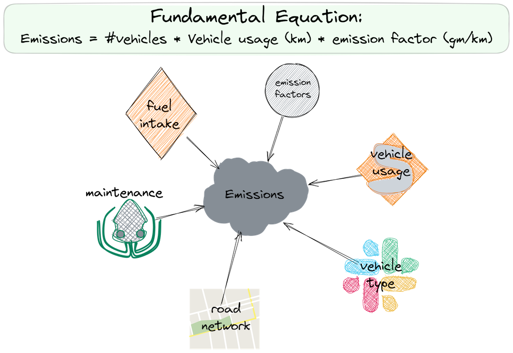
6]. Availability of information in such detail is higher in the European Countries, in the United States, and in some big cities of Asia and Latin America like Beijing, Shanghai, Delhi, Singapore, Bangkok, Bogota, and Sao Paulo, but openness and availability of this data in for small and medium sized cities in the low- and middle- income country is scarce. A typical equation to calculate on-road vehicle exhaust emissions (VEE) is
These three inputs determine the VEE loads – (1) how many vehicles are on the road (supply-side of the problem), (2) how much are these vehicles used on the road (demand-side of the problem, often measured as vehicle km travelled – VKT), and (3) how much is the pollutant emission factor on the road (technology-side of the problem, often measured as gm/km and dependent on the vehicle and fuel technology). Complexity of this equation multiplies exponentially with the increase in the types of vehicles, types of fuels, age-mix of the vehicles, usage of the vehicles, fuel economy of the vehicles, travel patterns in the city, types of roads, road conditions, and driver behaviour [
7]. Some of these variables are collectively referred to as in-use vehicle characteristics. When building the VEE inventory:
The number of vehicles on the road (supply-side) is not the same as the number of vehicles registered in the city (for the study year). These numbers must be adjusted to determine what fraction of the registered vehicles are still in-use (on the roads) and contributing to the emission loads every day [
8]. This is often achieved via use of survival functions.
The vehicle-usage (demand-side) is not a constant number for all the vehicle types or for the age-mix of the vehicles. This in-use vehicle usage determines the contributions of various vehicle types by age to the total emission loads in the city. Typically, the older vehicles tend to travel less than the newest vehicles.
Also, on the technology, the fleet average emission factor depends on the in-use fuel economy of the vehicles.
In this paper, we present a survey framework to profile the necessary in-use vehicle characteristics in a city.
2. Fuel Station Survey
Why fuel stations? The assumption here is that irrespective of a vehicle’s age or condition, if it is in-use, it will visit a station for refueling and their survey must represent the profile of in-use vehicles of the city. The key outputs of the survey for direct use in the VEE calculations are
The age-mix of the in-use vehicles by type – if there is access only to registered number of vehicles, this profile can be used as a first order approximation to deduce age-mix of the vehicles. The same profile can be used with yearly sales and registration numbers to construct survival functions for future calculations.
Changes in the vehicle usage (VKT) with age and type – usage functions can be constructed for future calculations.
Changes in the fuel economy with age and type – consumption patterns can be constructed with age and correlated with manufacturing reports for future calculations.
2.1. Case Study City: Patna, India
Patna (capital city of Bihar, India) has a population of 1.3 million, spread over 72 wards, located on the Indo-Gangetic plain (IGP), and is largely supported by agricultural activities. In 2023 world ranking, Patna was ranked 20
th most polluted city with an annual average PM
2.5 concentration of 82 μg/m
3 (
https://iqair.com), which is 16 times more than the World Health Organization guideline of 5 μg/m
3. This is a 30% improvement from 2017 because of promotion of clean fuels like liquified petroleum gas (LPG) and electricity for residential and commercial cooking and introduction of the best available vehicle and fuel standards (Bharat 6, equivalent of Euro 6) in 2020. Road transport continues to be one the main contributors to ambient PM
2.5 pollution in the city, along with residential and commercial cooking, heating in the winter months, open waste burning, emissions from point sources like the 300-brick kilns surrounding the city, and dust from construction activities and resuspension on the roads. On the IGP, Patna city is an important commercial hub with multiple highways crisscrossing, leading to movement of many freight vehicles through the city boundary every day. Emission inventory and chemical transport model-based studies estimated up to 30% of the annual average PM
2.5 originating from road transport [
9].
According to the Ministry of Road Transport and Highways (MoRTH), total registered vehicle fleet is approximately 2 million in 2023, with 70% two-wheelers (including mopeds, scooters, and motorcycles), 13% passenger four-wheelers including taxis, 7% three-wheelers for passengers and freight, 4% heavy duty and light duty vehicles, and rest covering public, contract, school, and private sector buses, para-transit vehicles, and non-road vehicles. Para-transit vehicles can carry three to ten passengers per trip, mostly covering short distances, and operate in dual fuel mode using petrol and compressed natural gas (CNG) or diesel and CNG. With dust resuspension from vehicle movement on the roads, road transport contributes up to 40-50% of the PM2.5 pollution in parts of the city.
Fuel Station Survey (FuSS) in Patna was conducted in August 2018 and coordinated by Urban Emissions (New Delhi, India) and Asian Development Research Institute (ADRI, Patna, India).
2.2. Number of Stations to Survey
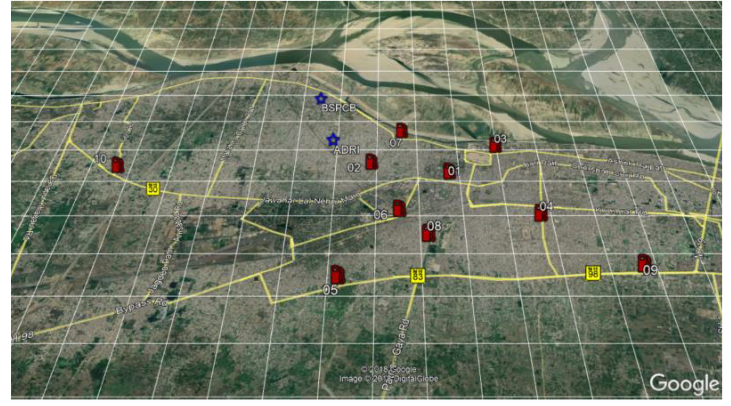
A representative set of locations must be selected depending on the objective of the final calculations. A list of operational fuel stations was extracted from
https://openstreetmaps.com and of the total mapped 90 stations, ten stations (approximately 10%) were selected to survey (
Figure 1). A limitation of this survey is the location of the fuel stations. If the survey is conducted at the stations within the city limits, the survey will mostly capture the passenger vehicles and if it is conducted at the stations outside the city limits, the survey is likely to capture the freight vehicles. Application in Patna was limited to the city administrative boundary capturing mostly passenger vehicles.
According to the Central Pollution Control Board (CPCB, New Delhi) guidelines for ambient pollution monitoring, mix of locations to observe air quality must include representation of residential, industrial, road, and background activities [
10]. A similar approach was taken for the selection of the survey stations to capture a mix of activities. Station location and operator’s information is presented in
Table 1 and a presentation file with google earth snapshots of the locations showing their surroundings is included in the supplementary material. Of the ten, three stations are owned by Indian Oil and seven by Bharat Petroleum. Permissions were obtained to conduct the survey at these select stations with the help of the Bihar State Pollution Control Board and ADRI staff.
2.3. Survey Questionnaire
The questionnaire is kept to a minimum, so that the questions to ask the driver or the owner of the vehicle can be accomplished in less than 2-3 minutes – the time taken to fill the fuel tank. A summary of the data points collected per survey is shown in
Table 2 and a sample copy of the questionnaire is included in the supplementary. There is also some waiting period for these vehicles in line to reach the fuel pump, which is often used to the surveyor’s advantage to explain why the survey is being conducted and to provide clarifications on how the data is used for emissions and pollution analysis.
Every questionnaire involved three surveyors. One at the fuel pump asking the three questions, one noting answers to questions which can be observed, and one crosschecking the entries and answering any questions from the driver. This reduced the overall interaction time with the driver and made room to address any survey-related queries. Only in a very few instances, the conversations were longer than 10 mins with an enthusiastic citizen who wanted to know more about the work. Keeping the questionnaire simple and to a minimum increased overall success rate of the data collection (>95% response rate). Most of the non-response cases were because the driver was in a rush and didn’t want to engage in a conversation.
The questionnaire was programmed into an open-source data management software ODK. A copy of the code is included in the supplementary. This app-based survey was designed to enable immediate digitization of the survey points, extract data for rapid statistical analysis, and track progress of data collection from day to day. Tracking of the number of surveys conducted at each station was useful in advising the surveyors, at the start of the day, on which fuel type and vehicle type to target that day, to capture a good mix of vehicles in the survey. A presentation with screenshots of data-entry steps from the ODK application for this survey is included in the supplementary.
2.4. Survey Sample Size
A large sample size is desirable. The number of stations to cover and availability of trained surveyors is one of the constraints for increasing the sample size. Target sample size was at least 1% of the registered passenger vehicle fleet in the city, which is at least 10,000 surveys in 2018. At the end of survey period, a total of 10,318 surveys were conducted and the final cleaned full dataset included 9,775 survey points. Some of the surveys were discarded for mixed reasons ranging from broken odometers, unreasonable reporting of fuel economy rates, and not knowing the manufacturing year (for example, in cases where the driver is not the owner of the vehicle).
2.5. Survey Training
Nineteen students from local colleges and universities participated in the survey, who were interning at the Asian Development and Research Institute as part of a summer environmental career development course. Before the survey, all the students were engaged in a two-day training course covering the aspects of air pollution and health, emissions and pollution modeling, data requirements, data availability, pollution management, and discussions specific to road transport emissions modeling. An updated set of course material is available open access at
https://urbanemissions.info/tools along with instructional videos, primers, working papers, and presentations. The course covered basic information necessary to answer any inquisitive questions like (a) what is the biggest contributing source of air pollution in the city? (b) is transport the main cause of air pollution in the city (c) why are we doing the emissions analysis and (d) how are we going to use the data collected to carry out emissions and pollution analysis. The training and capacity building included a session on dos and don’ts during the survey:
Always be courteous to the driver and the owner.
On the phone – (a) test the logins and passwords before doing the actual collection (b) check battery and space to avoid any crashes in the middle of the survey and (c) adjust the screen light to show the entries properly.
Strictly no demanding information. If the driver or the owner does not want to participate, then stop. If he/she agrees to answer all or part questions, then proceed. We want information only if they participate voluntarily.
Strictly no putting your head inside the car for the odometer reading or asking for the vehicle registration card. All numbers are noted only if the driver or the owner participates voluntarily.
Strictly no taking surveys outside the designated area of the fuel station.
For any random entry, use the word “TEST” for the vehicle registration number. This will help eliminate random entries from the final database.
A mock survey was conducted in the lab to get familiar with the questioning and the app for entering data. The first day of the survey was conducted with everyone at one station only, where three students followed the survey procedures, while others observed on the side.
3. Survey Application in Patna, India
3.1. Data Entry Lessons
App or Paper? A very important cultural lesson at the start of the survey was regarding the ODK app. There was hesitation among the drivers and the owners to participate in the survey, when the data was entered directly into the app at the fuel pump. They wanted to participate, but also wanted the surveyor to write down the answers, instead of entering in the app. Response rate at this hour was less than 50%. After an hour into the start on day-one, the data entry process was shifted to paper. At the end of each day, surveyors entered all the data points into the app and uploaded them to the central repository for processing. This helped keep the pace of the survey as planned, for collection and analysis.
Sometimes a driver was not able to answer the question on fuel economy which was noted as “what is the average mileage of this vehicle” (km/lit). Instead answers included “I put 5 liters of diesel in the morning and run for 150 km in a day, “I get 12 km/lit in the city and 16 km/lit outside the city” or “I get 12 km/lit when running with AC and 16 km/lit without AC”). These numbers were noted as ranges.
3.2. Patna In-use Vehicle Characteristics
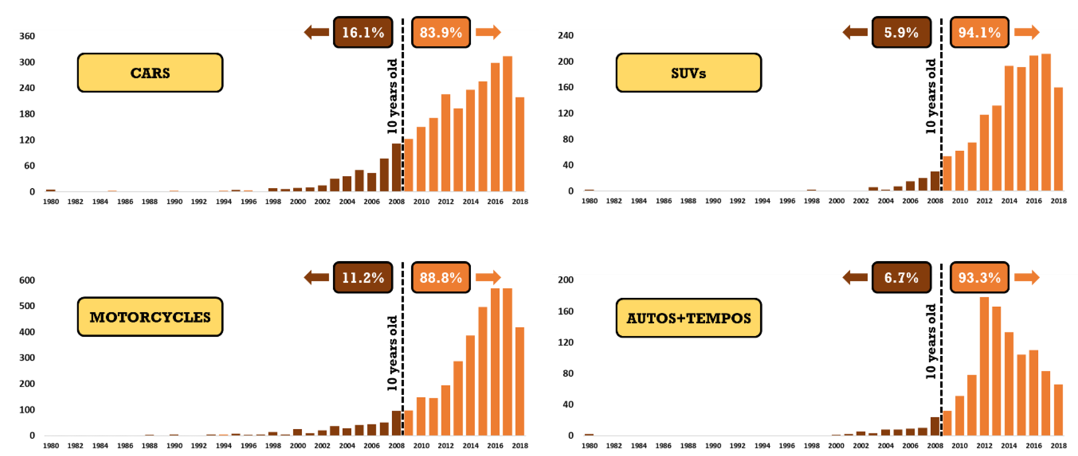
A summary of the survey results is presented in
Table 3 and
Figure 2. The survey was conducted over nine days, at ten fuel stations, using 19 students. The final cleaned sample size was 9775 with 41% covering all 2-wheelers, 46% covering all 4-wheelers, and 13% covering 3-wheelers and tempos. The fuel mix of the vehicles was 69% for petrol and 31% for diesel. All the motorcycles are petrol based.
The summary of average odometer readings is consistent with typical usage rates. For example, motorcycles travelling for one hour/day at average speeds of 20-25 kmph will cover 6000-7500 km in a year. Similarly, cars and SUVs travelling 2 hours/day at average speeds of 15-30 kmph will cover 9000-18,000 km/year (assuming 300 operating days). These typical rates are useful when no data is available or the option to conduct surveys is not available.
In addition to building the survival functions – to know the probability of a vehicle to continue to be in-use on the roads, the age-mix from the surveys (
Figure 2) can also be used for rapid assessment of the vehicle fleet management. For example: what are the impacts of banning vehicles older than 10 years or 15 years? Is it cost-beneficial to implement such a measure, if the older fleet size is too small to track and manage? Is it cost-beneficial to instead implement a stricter inspection and maintenance program, which ensures that the older vehicles also comply with the emerging vehicle standards.
3.3. Patna City Emissions and Pollution Modeling
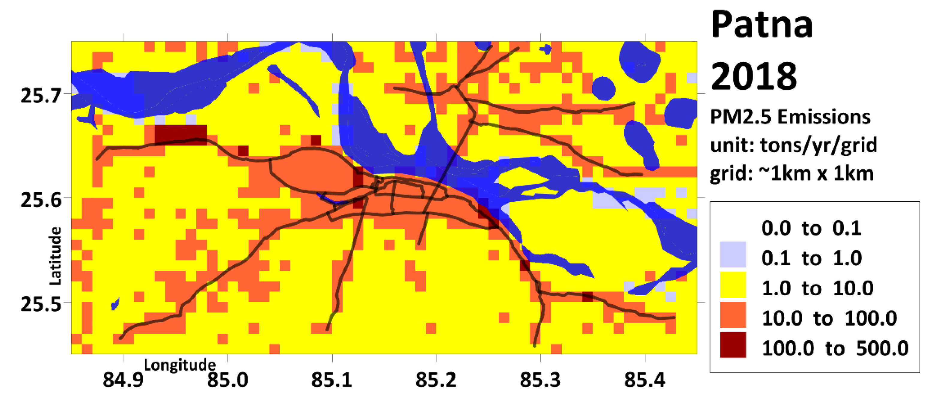
Survey results were a key input in establishing the emissions inventory baseline for the city of Patna. Combined with information on total registration of vehicles, vehicle usage, fuel sales, and a composite of emission factors, total emissions for all the criteria pollutants was calculated. Overlaying with the geospatial (GIS) databases like population density, urban-rural classification, density of roads as primary, arterial, and feeder, and density of commercial and industrial activities, the total emissions were further disaggregated into grids of 0.01º resolution. Details on how to access these GIS spatial proxies are explained in the supplementary.
Figure 3 presents a composite of total emissions from all the known sectors for the Patna airshed at the grid level. The spatial patterns resemble a combination of the urban-rural classification and the road network [
9].
The emissions inventory was also used to calculate the total PM
2.5 concentrations using a state-of-the-art chemical transport model (CTM -
https://camx.com) coupled with 3-dimensional meteorological data covering the entire airshed. These results were validated against the ambient measurements to increase the confidence levels in the emissions inventory and inputs used to build the inventory [
9]. The full methodology for building an emissions inventory and how to conduct CTM modeling are detailed in applications across Indian cities and other regions [
11,
12]. A copy of the model-ready emissions inventory and the CTM results are available upon request. All the ambient measurements information is collated from CPCB’s open data repository.
3.4. Patna City PM2.5 Scenario Analysis
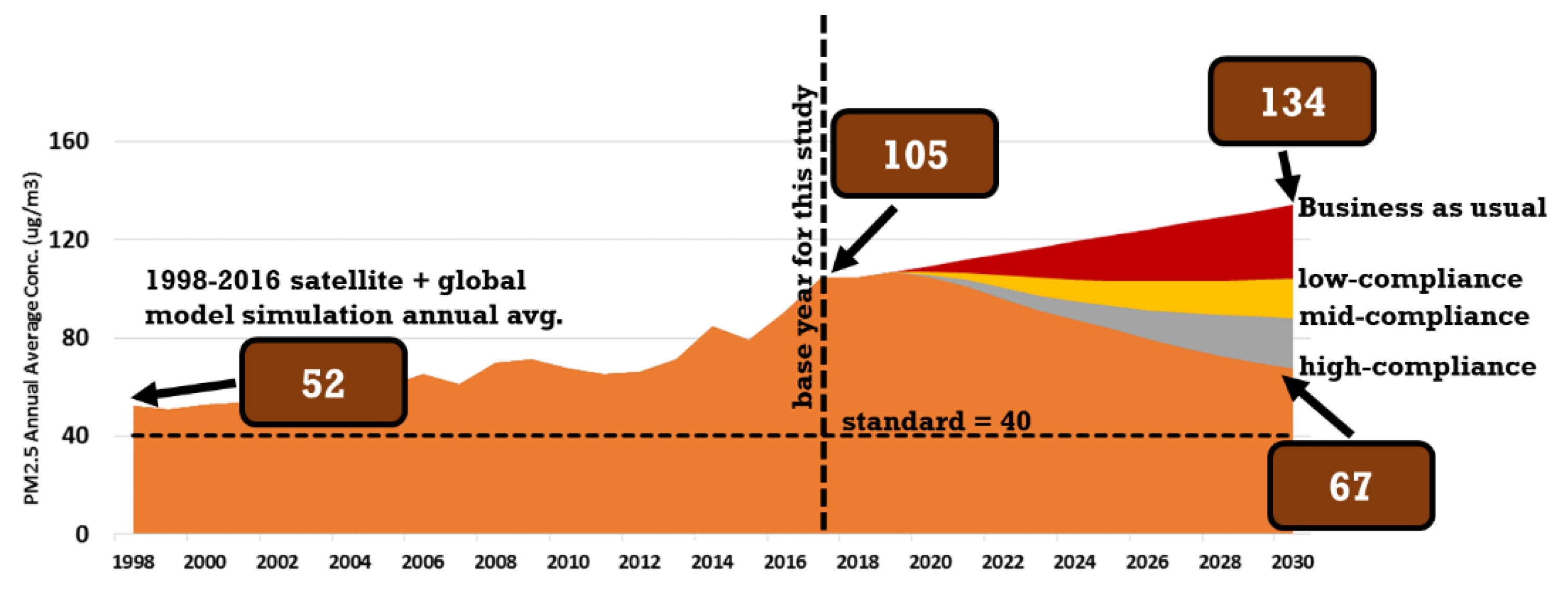
The emissions inventory and the CTM results were further used to assess a combination of the control measures under low-, medium-, and high-compliance scenarios for future years till 2030 (
Figure 4). In Patna, a 40% reduction in the annual average PM
2.5 concentrations is possible under the high compliance scenario – which is the clean air target for all the non-compliance cities under the national clean air programme of India [
13,
14]. Most of the interventions planned for this what-if analysis are for the transport sector. Some of the interventions are - promotion of electric vehicles for passenger vehicles; promotion of programs to reduce the private usage and increase the public transport shares; improvement of the vehicle inspection and maintenance program; and control of dust on the roads to reduce resuspension during vehicle movement. The vehicle combustion technology in India is already the best available. The results demonstrate the use of a reliable emissions inventory, supported by inputs from the surveys conducted at the fuel stations in the city.
3.5. Applications in Other Cities
The survey framework was pioneered at the TRIP-Centre of the Indian Institute of Technology (New Delhi, India), with an application in Delhi and followed by surveys in Visakhapatnam and Rajkot [
15,
16]. After Patna, surveys were also conducted in Gaya and Muzaffarpur (also in Bihar) and Indore (Madhya Pradesh). A variation of the survey was also used to analyze the freight vehicle characteristics on Indian highways [
17].
4. Way Forward
The fuel stations survey (FuSS) framework explained and demonstrated in this paper is a rapid-form survey, to collect data points necessary to establish the profile of in-use vehicles in a city. The survey can be implemented with the least amount of training for data collection and data collation. The ODK app-based data archiving method can enable tracking of the survey samples by day and as a bonus, allow for statistical analysis of the data within a day to a week’s timeframe.
The framework can be replicated in places other than the fuel stations, which will result in a mixed set of results, but still useful for studying the in-use vehicle characteristics. For example: A survey can be conducted at the malls (either inside the malls or at the parking lot). Since this is a select set of users driving to the malls, the results can be used to study the travel behavior between income groups in the city and add to the overall pool of data from other surveys. Another example is a form-based survey at the schools, where the students can ask their parents to anonymously participate with information on the vehicle characteristics and personal trip patterns. In addition to increasing the data pool, the same can also be used to expand the origin-destination travel matrix of the city, with the schools as destinations. When conducted en-masse, these surveys can provide a very rich dataset to not only evaluate the in-use vehicle characteristics, but also help with the spatial disaggregation of the emissions to grids across the city airshed.
The vehicle fleets are constantly changing, and it would be ideal to conduct such rapid surveys every 3 to 5 years, to track the vehicle characteristics and travel behavior in the cities.
Supplementary Materials
All the support files and presentations are available for open access at
https://doi.org/10.5281/zenodo.11515540. This includes (a) a presentation showing google snapshots of select fuel stations and their surroundings (b) A copy of the survey form (c) ODK app code which can be used to replicate or expand for similar applications and (d) a presentation showing the ODK screenshots on steps to enter data and save. All the GIS layers necessary for gridding total emissions are pre-extracted and archived for open use at
https://urbanemissions.info, along with example tools (under resources) to conduct vehicle exhaust emission calculations, scenario analysis, and spatial allocation to city grids. A version of tools (at the time of the submission of manuscript) is also uploaded to the public zenodo repository.
Author Contributions
“Conceptualization, writing original draft, review, and editing, S.K.G.; methodology, S.KG. and R.G.; software and data curation, N.K.; supervision and project administration, V.T.; funding acquisition, S.K.G. and V.T. All authors were involved with formal analysis and have read and agreed to the published version of the manuscript.
Funding
For conducting the surveys and emissions analysis in Patna, India, ADRI and Urban Emissions received funding from the Shakti Sustainable Energy Foundation (New Delhi, India) in 2018.
Informed Consent Statement
All the surveys were conducted on a voluntary basis. At the fuel stations, all the participants were explained why the data was being collected and how it would be used for emissions analysis.
Data Availability Statement
This methodology paper has no additional data to accompany this manuscript. The results from the survey and the tools for emissions and pollution analysis are available open access.
Acknowledgments
Authors would like to thank Late Prof Dinesh Mohan, who pioneered some of the transport survey frameworks in India and guided the team in the survey inception and initial applications in Delhi. Authors would like to thank the two anonymous reviewers for their time, suggestions, and comments in improving the manuscript.
Conflicts of Interest
Authors declare no conflict of interests.
References
- Sokhi, R.S.; Moussiopoulos, N.; Baklanov, A.; Bartzis, J.; Coll, I.; Finardi, S.; Friedrich, R.; Geels, C.; Grönholm, T.; Halenka, T. Advances in air quality research–current and emerging challenges. Atmospheric Chemistry and Physics Discussions 2021, 2021, 1–133. [Google Scholar] [CrossRef]
- Garland, R.M.; Altieri, K.E.; Dawidowski, L.; Gallardo, L.; Mbandi, A.; Rojas, N.Y.; Touré, N.d.E. Opinion: Strengthening Research in the Global South: Atmospheric Science Opportunities in South America and Africa. EGUsphere 2023, 2023, 1–14. [Google Scholar] [CrossRef]
- Gani, S.; Pant, P.; Sarkar, S.; Sharma, N.; Dey, S.; Guttikunda, S.K.; AchutaRao, K.M.; Nygard, J.; Sagar, A.D. Systematizing the approach to air quality measurement and analysis in low and middle income countries. Environmental Research Letters 2022, 17, 021004. [Google Scholar] [CrossRef]
- Vollset, S.E.; Ababneh, H.S.; Murray, C.J.L.; GBD-Collaborators. Burden of disease scenarios for 204 countries and territories, 2022-2050: A forecasting analysis for the Global Burden of Disease Study 2021. The Lancet 2024, 403, 2204–2256. [Google Scholar] [CrossRef] [PubMed]
- Pozzer, A.; Anenberg, S.C.; Dey, S.; Haines, A.; Lelieveld, J.; Chowdhury, S. Mortality Attributable to Ambient Air Pollution: A Review of Global Estimates. GeoHealth 2023, 7, e2022GH000711. [Google Scholar] [CrossRef] [PubMed]
- Lekaki, D.; Kastori, M.; Papadimitriou, G.; Mellios, G.; Guizzardi, D.; Muntean, M.; Crippa, M.; Oreggioni, G.; Ntziachristos, L. Road transport emissions in EDGAR (Emissions Database for Global Atmospheric Research). Atmospheric Environment 2024, 324, 120422. [Google Scholar] [CrossRef]
- Goel, R.; Guttikunda, S.K. Evolution of on-road vehicle exhaust emissions in Delhi. Atmospheric Environment 2015, 105, 78–90. [Google Scholar] [CrossRef]
- Guttikunda, S.K. Vehicle Stock Numbers and Survival Functions for On-road Exhaust Emissions Analysis in India: 1993-2018. Preprints 2024. [Google Scholar] [CrossRef]
- SPCB.<italic> Comprehensive Clean Air Action Plan for the City of Patna</italic>; Bihar State Pollution Control Board with consortium partners CSTEP, ADRI and Urbanemission.info: 2019.
- CPCB.<italic> Guidelines for Ambient Air Quality Monitoring</italic>; Central Pollution Control Board, Ministry of Environment Forests and Climate Change, Government of India: New Delhi, India, 2003.
- Guttikunda, S.K.; Nishadh, K.A.; Jawahar, P. Air pollution knowledge assessments (APnA) for 20 Indian cities. Urban Climate 2019, 27, 124–141. [Google Scholar] [CrossRef]
- UEinfo.<italic> Air Pollution knowledge Assessments (APnA) city program covering 50 airsheds and 60 cities in India</italic>; https://www.urbanemissions.info: 2019.
- India-PIB.<italic> NCAP targets to achieve reductions up to 40% of PM10 concentrations by 2025-26</italic>; Press Information Bureau, Release ID: 1914423, Government of India: New Delhi, India, 2023.
- Ganguly, T.; Selvaraj, K.L.; Guttikunda, S.K. National Clean Air Programme (NCAP) for Indian cities: Review and outlook of clean air action plans. Atmospheric Environment: X 2020, 8, 100096. [Google Scholar] [CrossRef]
- Goel, R.; Guttikunda, S.K.; Mohan, D.; Tiwari, G. Benchmarking vehicle and passenger travel characteristics in Delhi for on-road emissions analysis. Travel Behaviour and Society 2015, 2, 88–101. [Google Scholar] [CrossRef]
- Goel, R.; Mohan, D.; Guttikunda, S.K.; Tiwari, G. Assessment of motor vehicle use characteristics in three Indian cities. Transportation Research Part D: Transport and Environment 2016, 44, 254–265. [Google Scholar] [CrossRef]
- Malik, L.; Tiwari, G.; Thakur, S.; Kumar, A. Assessment of freight vehicle characteristics and impact of future policy interventions on their emissions in Delhi. Transportation Research Part D: Transport and Environment 2019, 67, 610–627. [Google Scholar] [CrossRef]
|
Disclaimer/Publisher’s Note: The statements, opinions and data contained in all publications are solely those of the individual author(s) and contributor(s) and not of MDPI and/or the editor(s). MDPI and/or the editor(s) disclaim responsibility for any injury to people or property resulting from any ideas, methods, instructions or products referred to in the content. |
© 2024 by the authors. Licensee MDPI, Basel, Switzerland. This article is an open access article distributed under the terms and conditions of the Creative Commons Attribution (CC BY) license (http://creativecommons.org/licenses/by/4.0/).
