1. Introduction
Over the last few decades, urbanisation has become a major developmental issue of global significance due to its magnitude, speed and impact. For instance, between 1950 and 2018, the share of the world’s population living in urban areas grew from 30% to 55% [
1]. Although sub-Saharan Africa is still the least urbanised region in the world, it is urbanising faster than any other region, with its urban population growing at about 3.6 million per annum [
2]. As at 2014, eight (8) out of the 10 most rapidly-urbanizing countries in the world were in sub-Saharan Africa, namely Rwanda, Niger, Mali, Burundi, Burkina Faso, Uganda, Eritrea and Tanzania [
3].
Physical expansion of cities and towns is required to accommodate the growing urban population, as well as release the potentials of urban centres as engines of economic growth. As has been noted “the physical growth of cities is not an anomaly, but a process that has characterized cities throughout history” [
4] (p. 46). Indeed, urban growth has long been associated with industrialisation and economic development [
5]. However, it can also lead to several environmental and socio-economic consequences that are inimical to sustainable urban development, if it is not effectively managed. In sub-Saharan Africa, much of urban growth has been unplanned and organic [
6]. Such growth negatively impacts the
green periphery—protected ecologically significant areas within the peri-urban zone that provide vital ecosystem services to urban dwellers [
7]. The green periphery, particularly wetlands, often gets encroached upon by the ever-growing built-up areas of poorly planned cities [
7,
8,
9].
Wetlands are transitional ecosystems that bear the characteristics of both aquatic and terrestrial environments, where the land is covered by shallow water or the water table is near the land surface [
10]. They include “areas of marsh, fen, peatland or water, whether natural or artificial, permanent or temporary, with water that is static or flowing, fresh, brackish or salt, including areas of marine water the depth of which at low tide does not exceed six metres” [
11]. Wetlands help in providing water and livelihood to humans, providing recreation, sustaining plant and animal lives, controlling erosion and floods, purification and storage of surface water, recharging of aquifers [
12,
13,
14], and slowing down global warming through carbon sequestration [
10,
12,
15]. Notwithstanding their critical importance, wetlands are increasingly being lost to rapid urbanisation. For instance, about 64% of the world’s wetlands have been lost since 1900 [
16]. In the Ndop Central Subdivision of the Ngoketunjia Division in the North West Region of Cameroon, Kometa et al. estimate that the built-up area increased from 3.9 km
2 in 1999 to 11.7 km
2 in 2017 while wetlands declined from 11.5 km
2 to 7.5 km
2 during the same period [
17].
The urbanisation process can be in harmony with the environment, including wetlands and other ecosystems, only when urban growth is consciously managed in a sustainable manner. This requires a good understanding of the nature and patterns of urban growth, the underlying forces, and the structure and form they create [
18]. Elsewhere, scholars have undertaken rigorously quantitative research on the morphological patterns and drivers of urban growth on wetlands and other ecologically important landscapes [
19,
20]. However, little work in this area has been done on urban wetland landscapes in Ghana, and for that matter sub-Saharan Africa. This has partly contributed to the environmentally unsustainable way the region’s growth has proceeded, sometimes manifesting in the fast depletion of its urban wetlands. To contribute to the filling of the knowledge gap, this paper combines geospatial and statistical techniques to quantitatively analyse the morphological patterns and drivers of urban growth on the Densu Delta Ramsar site in Ghana.
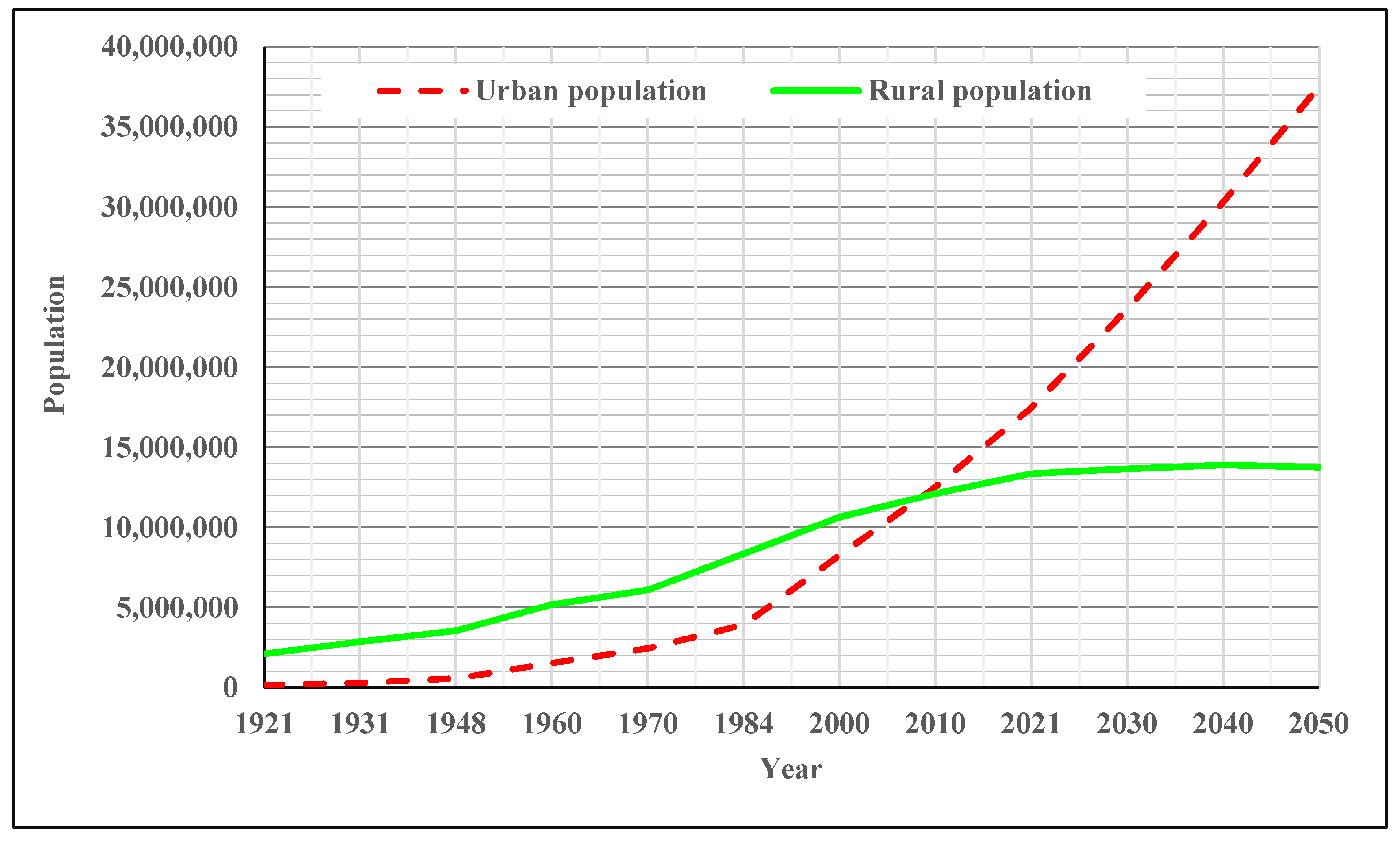
Like the rest of the developing world, Ghana has been experiencing rapid urbanisation for some time. As
Figure 1 shows, the country’s urban population increased from just 179,119 (representing 7.8% of the total population) to 17,472,530 (representing 56.7% of the total population) between 1921-2021. At an annual growth rate of 2.6%, it is projected that the country’s urban population will reach 37,518,000 by 2050, representing 73.2% of the national population [
21].
The high tempo of urbanisation is fuelled by both natural increase and rural-to-urban migration [
4,
27], resulting in fast growth in the physical expanse of existing cities and towns. This poses a major threat to ecologically-sensitive areas in the country’s urban areas, including the Densu Delta Ramsar site. The site, located in the Greater Accra Metropolitan Area (GAMA), exemplifies African wetlands that have been adversely affected by rapid urbanisation. The study analyses the magnitude, speed and morphological patterns of urban growth at the site and the extent to which this growth has been driven by proximal factors such as the presence of the city of Accra, road network, and nearby village magnets. Findings and lessons from the study will enrich scholarly discourse on urban growth on wetlands and inform sustainable urban planning efforts. Methodologically, the study adds to existing knowledge by combining
Aggregate Building Coverage Ratios (ABCRs) with
Land Use/Land Cover (LULC) analysis in quantifying and assessing the patterns of urban growth. While LULC is commonly used in similar studies (e.g. Weable, 2019), the use of ABCRs to quantitatively model the morphological patterns of urban growth is a novelty. Although this study shares a similarity with the one conducted by Doan and Oduro (2012) regarding the use of geospatial and regression techniques to analyse the influence of spatial drivers on urban growth, the reliance on ABCRs in the current study marks a point of departure from their methodology.
The study concludes that urban growth patterns at the Ramsar site are consistent with the spreading pancake, village magnet and ribbon development models, although the primary force behind the growth is increasing demand for land for residential development. This is exacerbated by the failure of state institutions to perform their land use control and wetland protection functions.
2. Conceptualising Urban Growth from a Morphological Perspective
Urban growth refers to an increase in an urban area's population and physical size. As part of the urbanisation process, cities and towns experience population growth through natural increase, migration and the incorporation of nearby peri-urban communities into an urban agglomeration. Urban population growth and growth in the volume of socio-economic activities lead to the physical expansion of the urbanised area [
4,
27]. The expansion includes new residential and infrastructural developments to accommodate the extra residents and the socio-economic activities. The physical expansion also results from increased per capita demand for space due to growing household income, affluence, declining household size, a shift from traditional compound houses to single-family housing units, and other sociological and lifestyle changes independent of population growth. The effects of these factors include changes to the size, shape and composition of the urban form through
infill development,
vertical layering, and
horizontal spread [
29].
Infill development is the inward expansion of a city through the development of patches of undeveloped spaces within the existing built-up area. Urban consolidation through in-filling could be a well-planned, land-use-optimisation strategy to deal with the leapfrog-development form of urban sprawl [
18]. However, it can also result from unplanned and uncontrolled residential, industrial and commercial development in open spaces, wetlands, waterways and other preserved lands not zoned for such developments.
Vertical layering refers to upward expansion through the construction of high-rise buildings, especially in and around the city centre, while leaving enough green open spaces among the buildings [
29]. It aims to increase the built-up area's aggregate floor area ratio (FAR) by optimising ground and air space to create sustainable densities and livable urban environments. In vertical layering, buildings are usually tallest in the city centre, where land is most expensive, and decline in height with distance from the city centre towards the suburbs, creating a pyramid-shaped skyline. Because high-rise building construction is capital-intensive, pyramidal expansion is usually associated with high-income and economically productive cities with high demand and land prices [
29].
Horizontal spread refers to the outward or lateral expansion of the built-up area. This phenomenon is associated with low-income cities where land prices are relatively low and buildings are generally short [
29]. In horizontally-spreading metropolitan areas, central-city densification and space optimisation are achieved not through vertical development but through overcrowding and slum formation with associated negative implications for public health and quality of life. Horizontal spread is dominant in African cities, including Accra, where few buildings exceed 10 metres in height [
29].
In hypothesising the drivers of urban growth at the Densu Delta Ramsar Site, this study adapts three of the morphological growth models used by [
28] to analyse peri-urban growth patterns in Accra:
spreading pancake, ribbon development and
village magnets.
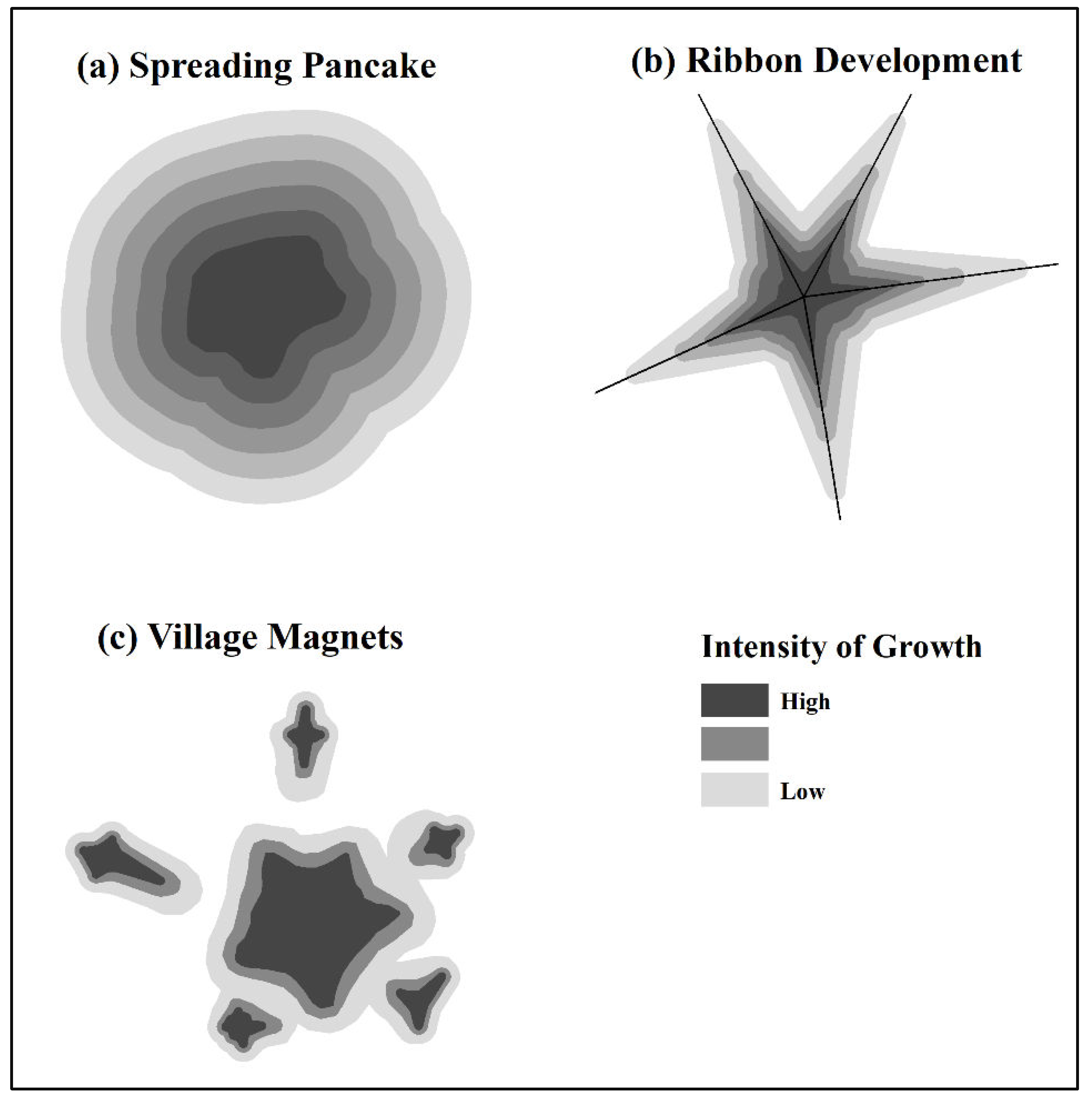
2.1. Spreading Pancake
Proximity to the city centre influences urban growth and form. Accessibility to the centre (regarding travel time) is crucial for residents because this part of the metropolitan area has high concentrations of urban services and jobs (livelihoods) they need to access. Therefore, locations near the centre experience more intense growth than the edges [
18,
30]. However, over time, as population, economic activities and demand for space grow, space at and around the centre gets exhausted, and growth spreads horizontally to the urban fringe in a manner akin to a spreading pancake [
28] (see
Figure 2(a)). Reminiscent of von Thünen’s 1826 agricultural land use model and the monocentric bid-rent model popularised by William Alonso, Richard Muth and Edwin Mills in the 1960s and 1970s, the spreading pancake model assumes the existence of a dominant central city that drives outward urban growth in concentric waves across a metropolitan area [
18,
31]. Thus, based on the spreading pancake hypothesis, locations at the Densu Delta Ramsar site that are closer to Accra, the central city, are expected to experience more significant amounts of physical growth than locations that are farther from the city.
Figure 2.
Patterns of Horizontal Urban Growth. Source: Authors’ construct
Figure 2.
Patterns of Horizontal Urban Growth. Source: Authors’ construct
2.2. Ribbon Development
Ribbon development occurs when the horizontal spread of the contiguously built-up area of a metropolitan area happens axially along arterial roads, leaving swathes of undeveloped or rural landscape between them [
18]. On one hand, urban residents seek to have unimpeded access to the city centre, where jobs and socio-economic amenities exist in high concentrations; on the other hand, they seek to enjoy cheap, spacious living environments available at the urban peripheries [
18,
28,
32]. These two conflicting demands can only be met through the mediating effect of a reliable transportation system that allows residents to have their dwellings in suburbia and commute to the city centre or elsewhere within the metropolitan area at affordable costs in terms of travel time and money spent (see
Figure 2(b)). Thus, transportation technology and infrastructure improvements and growing automobile ownership have contributed significantly to the horizontal expansion of cities and metropolitan areas [
29,
32,
33]. For instance, the expansion of Shenzhen, China, which is influenced by the development of transport corridors, follows this pattern of urban growth [
33]. In low-income metropolitan areas, most commuter trips are made via a few paved arterial roads connecting the central city to other parts of a country or region in radial patterns. While these radially-oriented major arterials are discretely spaced, engineered circumferential arterials, minor arterials, and connectors are either non-existent or unmotorable, especially in the peri-urban parts of metropolitan areas [
18]. Under such conditions, it is only rational for developers to site residential, industrial, commercial and other structures along or close to major arterial roads to enhance accessibility and the value of their properties. Therefore, in this study, we expect locations near arterial roads at the Densu Delta Ramsar site to experience higher concentrations of urban growth than locations farther away.
2.3. Village Magnets
Village magnets are pre-existing peri-urban communities that attract rapid growth in population and physical development as part of the spillover effect of the growth of an urban area. In Africa, residential development in the peri-urban zone often precedes the provision of basic infrastructure such as access roads, piped water, electricity and educational facilities due to a lack of planning, financial and managerial capacity of local governments to keep pace with rapid urbanisation concerning infrastructure development [
34]. As a result, peri-urban communities with some of these critical facilities and services tend to attract urban residents seeking cheap land for housing construction. Thus, over time, these pre-existing settlements “become the nuclei of fast-growing densely populated pockets surrounded by slow-growing sparsely populated areas” [
28] and eventually merge with the contiguously built-up area of the city (see
Figure 2(c)). In this study, the immediate environs of peri-urban settlements located at the Densu Delta Ramsar site are expected to attract faster urban growth than other locations.
2.4. Geographical, Economic and Institutional Drivers of Urban Growth
The extent to which proximity to the central city, transportation routes and village magnets impact urban form can be mediated by geographical, economic and institutional factors. Concerning geography, factors such as location, topography, geology and hydrology can influence urban form by either constraining or aiding physical development [
18,
29,
32]. For instance, in Hong Kong, the “total built-up area is limited by its island geography, pushing its population density—defined as the ratio of people to the built-up area—extremely high” with limited possibilities for horizontal spread [
29].
Cities are engines of economic growth, so their form and structure are influenced by economic factors [
29,
35]. For instance, land price and housing rent, household income and the fiscal health of local governments concerning infrastructure provision and maintenance can determine the speed and direction of urban growth. In economically productive and wealthy cities where scale and agglomeration economies are well-developed, the speed of horizontal spread is moderated by upward growth [
29].
With land use planning, zoning, subdivision regulations, building codes, and other uses of police power, city governments can influence urban form by directing, facilitating, discouraging or prohibiting specific forms of physical development at any given location [
32,
35]. For instance, upward growth is favoured in cities “where property rights are clear, land values are transparent, land use and zoning are compatible with local preferences, and the enabling environment encourages durable investment in infrastructure” [
29]. Thus, in most cities in the developing world, where planning and coordination of market-driven investments are ineffective because of weak institutions, outward growth is more dominant than upward growth.
3. Materials and Methods
3.1. The Study Setting
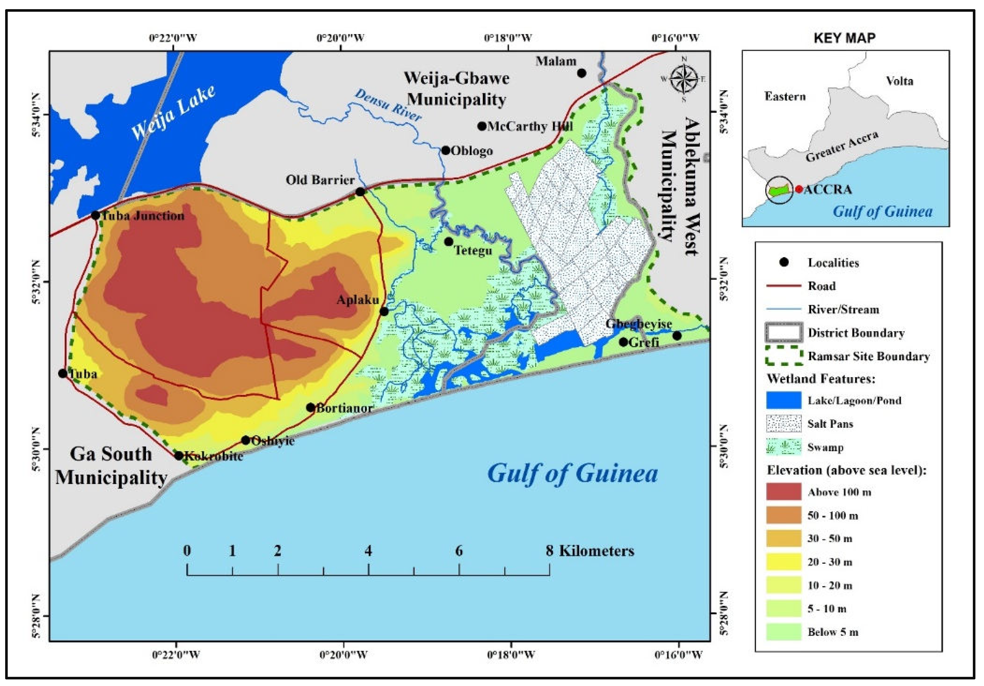
The 5,893-hectare Densu Delta wetlands were designated a Ramsar site in 1992 [
36]. Located between latitudes 5°29'45"N and 5°34'20"N and longitudes 0°15'33"W and 0°23'16"W, the site straddles the Ga South and Weija-Gbawe Municipalities in the Greater Accra Region (see
Figure 3). The Gulf of Guinea also bounds it in the south and the Weija Lake (an artificial lake created by constructing the Weija Dam on the Densu River) in the northwest. The eastern half of the protected site, where the core wetlands are located, is generally flat and low-lying, with an elevation of less than 5m above sea level. However, the eastern half is primarily hilly, rising to 100m above sea level.
Figure 3.
Physical Features of Densu Delta Ramsar Site. Source: Authors’ construct
Figure 3.
Physical Features of Densu Delta Ramsar Site. Source: Authors’ construct
The wetland ecosystem within the protected area includes a delta formed by the Densu River, lagoons, salt pans, freshwater marshes and scrubs, and streams [
37]. During the dry season, water flow from the Densu River to the wetlands is interrupted by the Weija Dam, located approximately 11 km upstream [
38]. However, during the rainy season, excess water from the dam is discharged downstream, and this, together with an increased volume of water from surrounding streams and surface runoff, causes the delta and the lagoons to overflow their banks, leading to flooding in low-lying communities such as Gbegbeyise and Glefe. The seasonal flooding also brings detritus, nutrients and pollution [
39]. The vegetation at the site comprises about 136 plant species made up of 50 flowering plant families, including mangroves, reeds and sedges [
37]
. The site also serves as a habitat for about 35,000 birds belonging to 57 species; reptiles such as snakes, lizards and turtles; mammals; marine and freshwater fish and shellfish species; and other invertebrates [
37,
40].
Notable communities within the protected area are Bortianor, Kokrobite, Oshieyie, Aplaku, Tetegu, Gbegbeyise and Glefe, all existing before the Ramsar site designation. Spillovers from the growth of Accra have resulted in rapid population growth in these and other peri-urban communities. For instance, available census data show that the combined population of the above communities was only 3,669 in 1970 but increased dramatically to 28,216 in 2000 and 87,852 in 2010. Similarly, the combined population of four communities close to the protected area—Malam, McCarthy Hill, Mpoase and Oblogo—increased from 3,954 to 50,530 between 1970 and 2010, respectively.
The main economic activities at the protected area before its Ramsar site designation included fishing, crop farming and salt winning [
37]. However, crop farming is currently limited while industrial and commercial activities have become predominant. The rapid growth in population and non-farm economic activities has accelerated the construction of residential and other buildings, leading to significant loss and degradation of the wetlands.
3.2. Study Methodology
The aim of the study, which commenced in 2023, is to analyse the magnitude, speed and morphological patterns of urban growth at the Densu Delta Ramsar site. it also analyses the extent to which this growth has been driven by proximal factors such as the presence of the city of Accra, road network, and nearby village magnets. To achieve this, satellite images were acquired and analysed using various geospatial and statistical techniques, which were supplemented by ground truthing and limited interviews by the researcher during visits to the study area.
3.2.1. Land Use/Land Cover Analysis
The loss of the Ramsar site to urban growth was preliminarily assessed though spatio-temporal analysis of land use/land cover (LULC) data. The LULC analysis spanned a 20-year period, from 2003 to 2023. The choice of this period was informed by the fact that most of the urban growth at the site occurred during this period.
Data were obtained from the United States Geological Survey’s (USGS’s) Landsat images [
41]. Data for 2003, 2008 and 2013 were obtained from Landsat 7 images while data for 2018 and 2023 were from Landsat 8 and Landsat 9, respectively (
Table 1). With the aid of version 3.34 of the QGIS software, the images were processed and classified using the supervised classification method. The classes were vegetation (including reeds, shrubs, grass and croplands), water (including rivers, streams, lagoons, ponds and salt pans), bare land (scraped surfaces, sandy surfaces, etc) and built-up areas (including buildings, roads and other artificially constructed physical structures).
3.2.2. Using Geospatial Technology to Compute ABCRs
The study used ABCRs (aggregate building coverage ratios) to measure and analyse the magnitude, speed and pattern of physical urban growth at the study site between 2013-2023. ABCR is a modified version of
building coverage ratio (BCR). BCR, also known as site coverage, is a zoning concept used to regulate the intensity of urban land use. It is defined as the ratio of the coverage area of the building(s) or other physical structures erected on a single plot to the total
plot size when viewed vertically from the sky [
42,
43]. Similarly, the term ABCR is used in this study to refer to the ratio of the aggregated coverage area of all building(s) erected in a
sector to the total sector area. A sector comprises multiple plots.
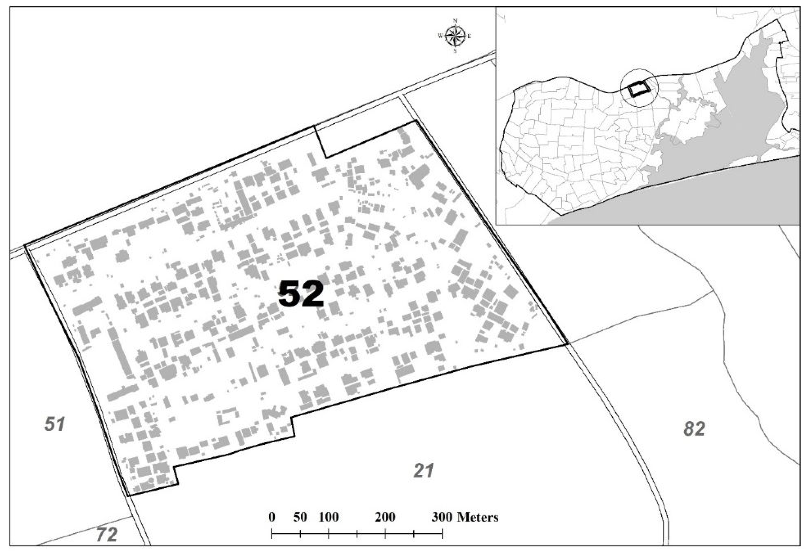
Generation of data for the computation of ABCRs was done using the ArcGIS (version 10.8.2) software to digitise the coverages of all existing buildings at the study site based on high-resolution satellite images extracted from the Google Earth application for the years 2013, 2018 and 2023. The same software and images were used to digitally divide the site into ‘sectors’ using roads, streams and other physical barriers as boundaries. This is illustrated in Figure 4.
Figure 4.
Building coverages in a sector. Source: Authors’ construct
Figure 4.
Building coverages in a sector. Source: Authors’ construct
Based on the digitised data (in the form of shapefiles), sector and building coverage areas were electronically computed in ArcGIS, which in turn allowed the ABCR of each sector to be computed as:
where
Ai = Coverage area of building i (in m2)
B = Sector area (in m2)
0 ≤ ABCR ≤ 100
3.2.3. Variable Description
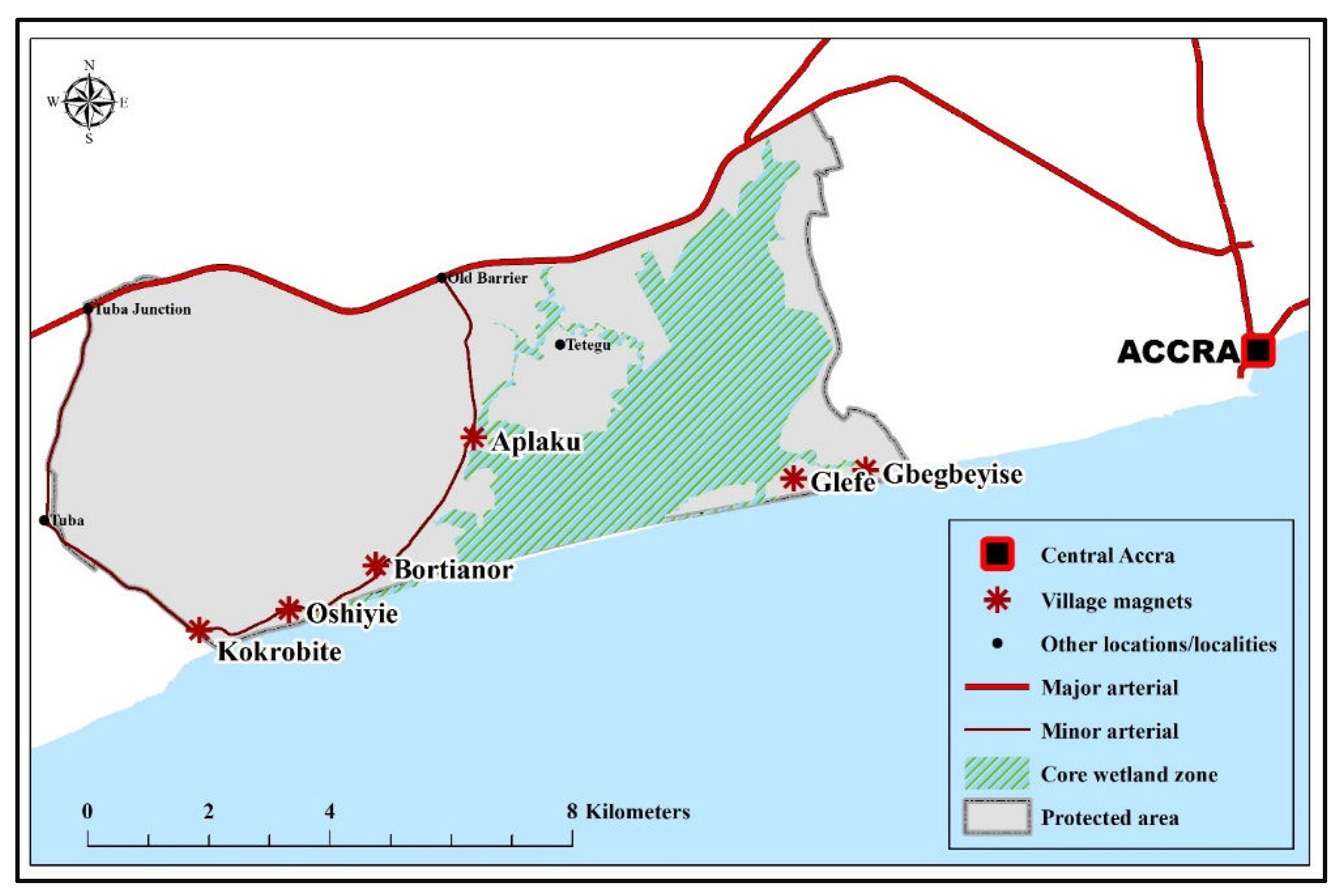
The main variables used for data generation and analysis included ABCRs, changes in ABCRs and proximity to the three urban growth drivers—Accra, arterial roads, and village magnets. The major arterial, a segment of the N1 highway connecting Accra to the southwestern part of the country and Abidjan (Cote d’Ivoire), forms the northern boundary of the Ramsar site. In contrast, the minor arterial is a 15.8-kilometre paved secondary road connecting communities at the site to the N1 highway. The pre-existing peri-urban localities serving as village magnets include Kokrobite, Oshiyie, Bortianor, Aplaku, Glefe and Gbegbeyise (see Figure 5).
Figure 5.
Map of Densu Ramsar Site Showing Urban Growth Drivers. Source: Authors’ construct
Figure 5.
Map of Densu Ramsar Site Showing Urban Growth Drivers. Source: Authors’ construct
In addition to the growth drivers, the possible effects of natural features on urban growth were controlled for. These include steep terrain and nearness to marshy areas, both of which were assumed to inhibit growth (see Table 2).
Table 2.
Description of Variables.
Table 2.
Description of Variables.
| Variable Name |
Description/Measurement |
Variable Type |
| Outcome variables: |
| ABCR13 |
ABCR in 2013 |
Continuous |
| ABCR18 |
ABCR in 2018 |
Continuous |
| ABCR23 |
ABCR in 2023 |
Continuous |
| CHNGE1 |
Absolute change in ABCR, 2013-2018 |
Continuous |
| CHNGE2 |
Absolute change in ABCR, 2018-2023 |
Continuous |
| CHNGE3 |
Absolute change in ABCR, 2013-2023 |
Continuous |
| Predictors: |
| ACC |
Distance from Accra (km) squared |
Continuous |
| VILL |
Located within 1 km of a village magnet |
Dichotomous (Yes = 1, No = 0) |
| ROAD1 |
Located within 1 km of a major arterial road |
Dichotomous (Yes = 1, No = 0) |
| ROAD2 |
Located within 1 km of a minor arterial road |
Dichotomous (Yes = 1, No = 0) |
| WET |
Located within 1 km of the wetland core |
Dichotomous (Yes = 1, No = 0) |
| ELEV |
Elevation exceeding 50m above sea level |
Dichotomous (Yes = 1, No = 0) |
3.2.4. Statistical analytic Techniques
With the sectors serving as units of analysis, the study employed tables, graphs, maps and other descriptive statistical tools to analyse the magnitude, patterns and trend/rate of physical growth based on the outcome variables listed in
Table 2. To test the spreading pancake, ribbon development, and village magnet hypotheses, multivariate regression techniques were employed to establish the statistical significance of the growth drivers on the outcome variables
. This began with fitting an ordinary least square (OLS) multiple linear regression model, which is of the form:
where
Y = outcome variable; predictors; = intercept; coefficient of ; = error term
Various diagnostic procedures were conducted to check for five multiple linear regression assumptions: normality, linearity, non-multicollinearity, multivariate normality, homoscedasticity and absence of autocorrelation. A Jarque-Bera normality test showed that the predictor ACC violated the normality assumption, and this was resolved by squaring the variable (renamed as ACC2). There were no serious violations of the linearity assumption.
Multicollinearity tests using scatterplots, correlation coefficients and variance inflation factors (VIFs) showed that the variables ACC2 and WET were highly correlated with a Pearson correlation coefficient of –0.73, while the remaining predictors showed very low multicollinearity. Hence ACC2 was retained while WET was dropped.
Although Jarque-Bera tests for normality showed some violation of the multivariate normality assumption, visual examinations of kernel density histograms showed the extent of violation was minimal. Besides, non-normality of residuals does not seriously affect the F-statistic regression coefficients and other related hypothesis-testing procedures in terms of significance and power [
44].
Visual inspection of scatterplots of residuals against fitted values of the outcome variables and formal Breusch-Pagan/Cook-Weisberg tests showed no severe violation of the homoscedasticity assumption. However, as expected, a visual inspection of choropleth maps of ABCRs and ABCR changes revealed some clustering in the distribution of these variables, implying a possible spatial autocorrelation. A formal diagnosis was conducted using Moan’s tests.
Moran’ I, which is based on spatial weighting, defined as:
where:
n is the number of spatial units indexed by i and j
x is the variable of interest with being the arithmetic mean of x
w is a matrix of spatial weights
W is the sum of all wij
A joint Moran test based on
contiguity and
inverse distance weighting matrices showed no statistically significant spatial dependence in three outcome variables—CHANGE1, CHANGE2 and CHANGE3 (see
Table 3). Therefore, the OLS linear regression method was maintained for these variables, with the model being specified as:
However, for the outcome variables ABCR12, ABCR17 and ABCR22, serious spatial autocorrelation problems were found (see
Table 3). This was resolved by using spatial autoregressive (SAR) models in place of OLS regression models.
The SAR model is of the form:
where
Y is the outcome variable; is the intercept; are predictors; are coefficients ; is a spatial lag of Y based on weighting matrix with as its coefficient; and represents a spatial lag of the autoregressive error term with rho being autocorrelation parameter and I being an identity matrix.
Thus, based on the variables under consideration, the SAR model was specified for each of the three outcome variables (ABCR12, ABCR17 and ABCR22) as:
The generalised spatial two-stage least squares (GS2SLS) estimator, robust to violations of the assumption of normally distributed residuals [
45], was used to fit the SAR model.
3.2.5. Ground Truthing and Interviews
In addition to generating geospatial data from satellite images, the study involved ground truthing and key informant interviews. The ground truthing exercise involved the research team paying visits to the study site to relate the remotely sensed data with features on the ground. The visits, which were necessary to aid data interpretation, offered the team the opportunity to directly observe the state of the wetlands, the nature of buildings constructed, and other human activities taking place at the site, as well as identify the use of the structures constructed at the site. In all, the uses of 163 randomly selected completed buildings were identified.
The key informant interviews were conducted with purposively selected officials of four key state agencies responsible for protecting wetlands against uncontrolled urban growth: Environmental Protection Agency, Wildlife Division of the Forestry Commission, Water Resource Commission, and the Ga South Municipal Assembly. The interviews focused on reasons for physical development at the study site despite its official status as a protected Ramsar site.
4. Results
4.1. Land Cover Depletion at the RAMSAR site
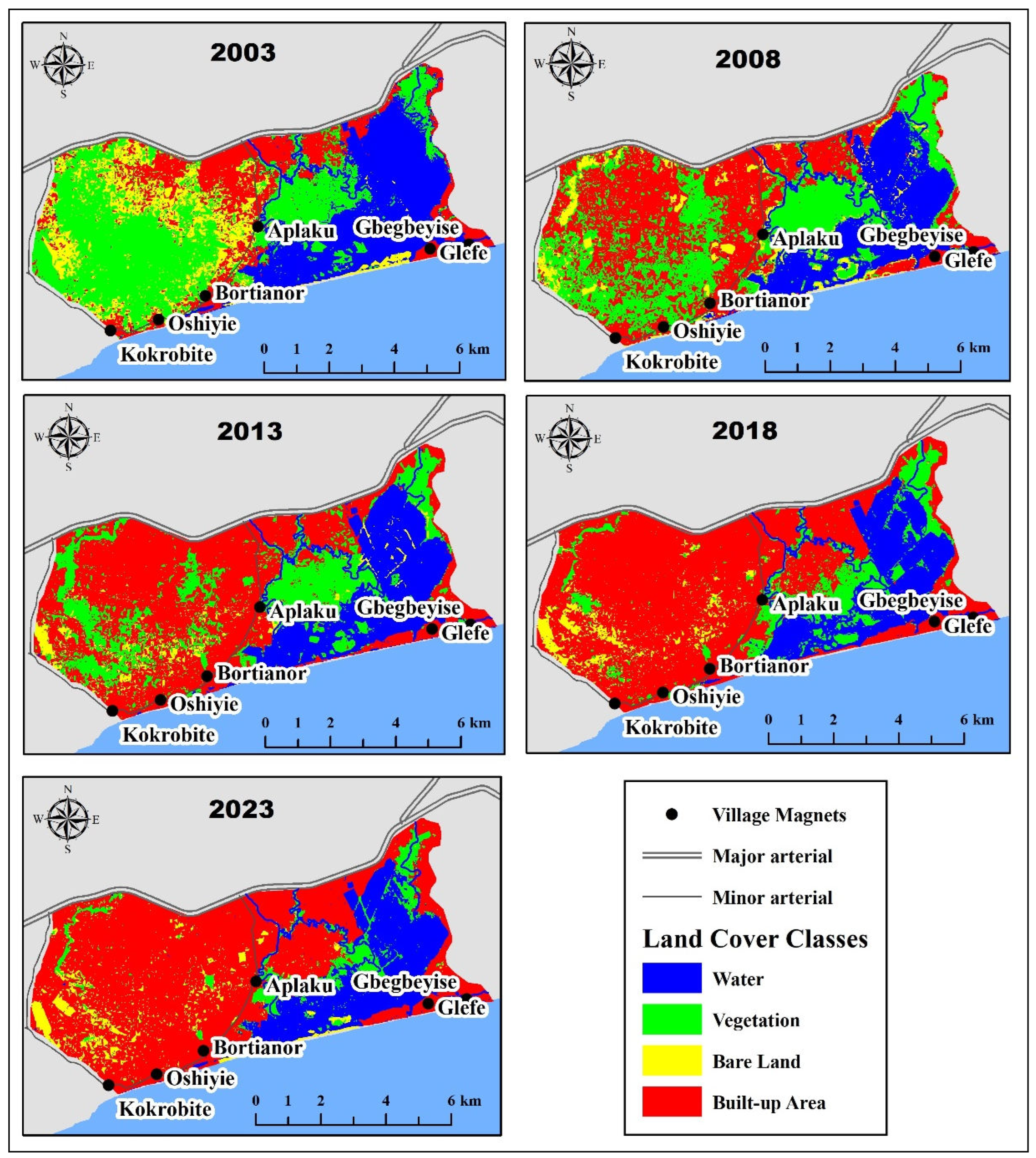
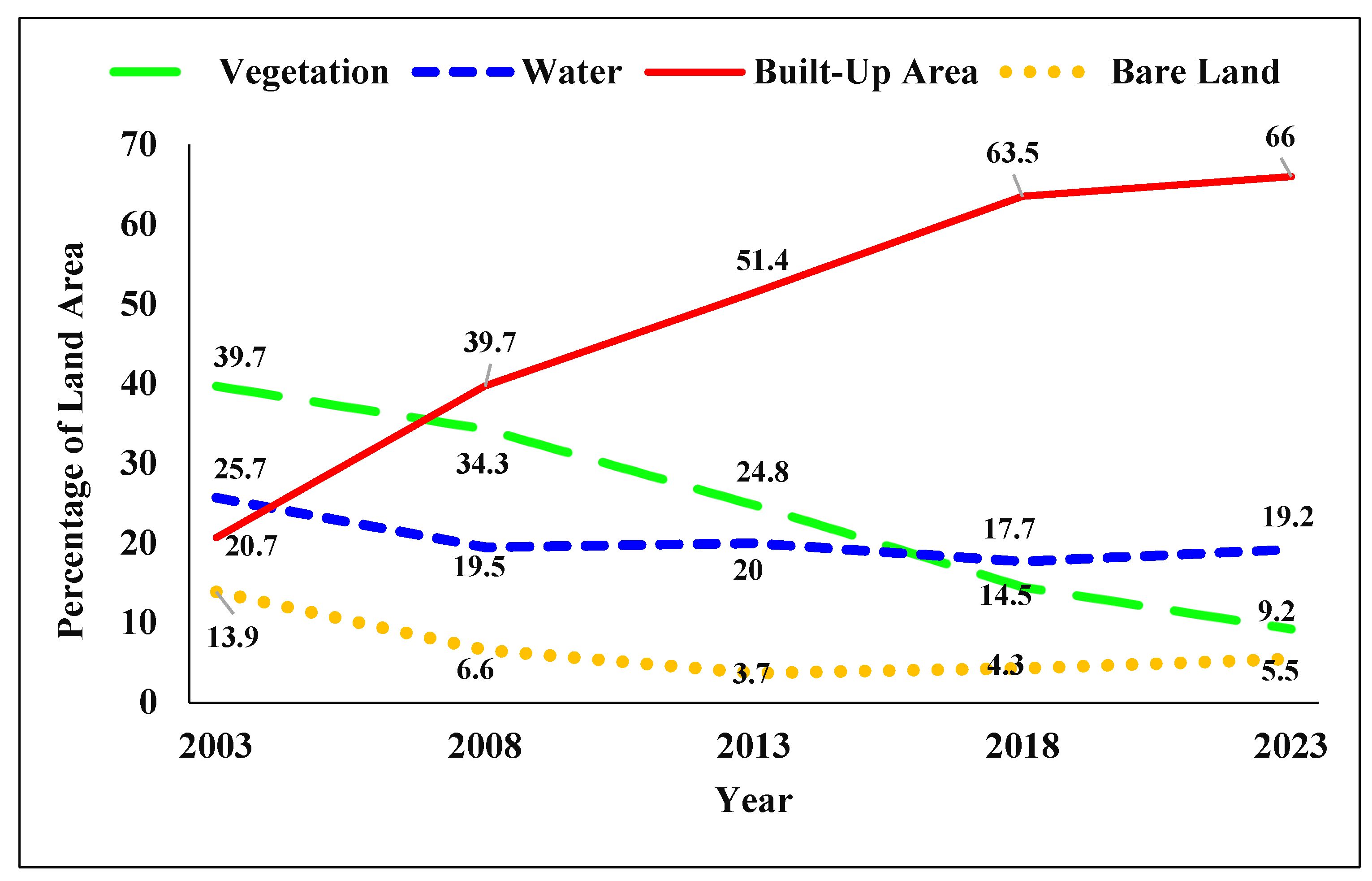
Results of the LULC analysis show a dramatic transformation of the Densu Delta Ramsar site over the last 20 years. As
Figure 6 and
Figure 7 show, all the four landcover classes have undergone either an increase or a reduction in size, with vegetation and built-up area showing the most remarkable changes. For instance, while the built-up area more than tripled between 2003-2023, vegetation declined by 77% during the same period. Apart from vegetation, there were also considerable declines in the area occupied by bare land and water (see
Figure 7).
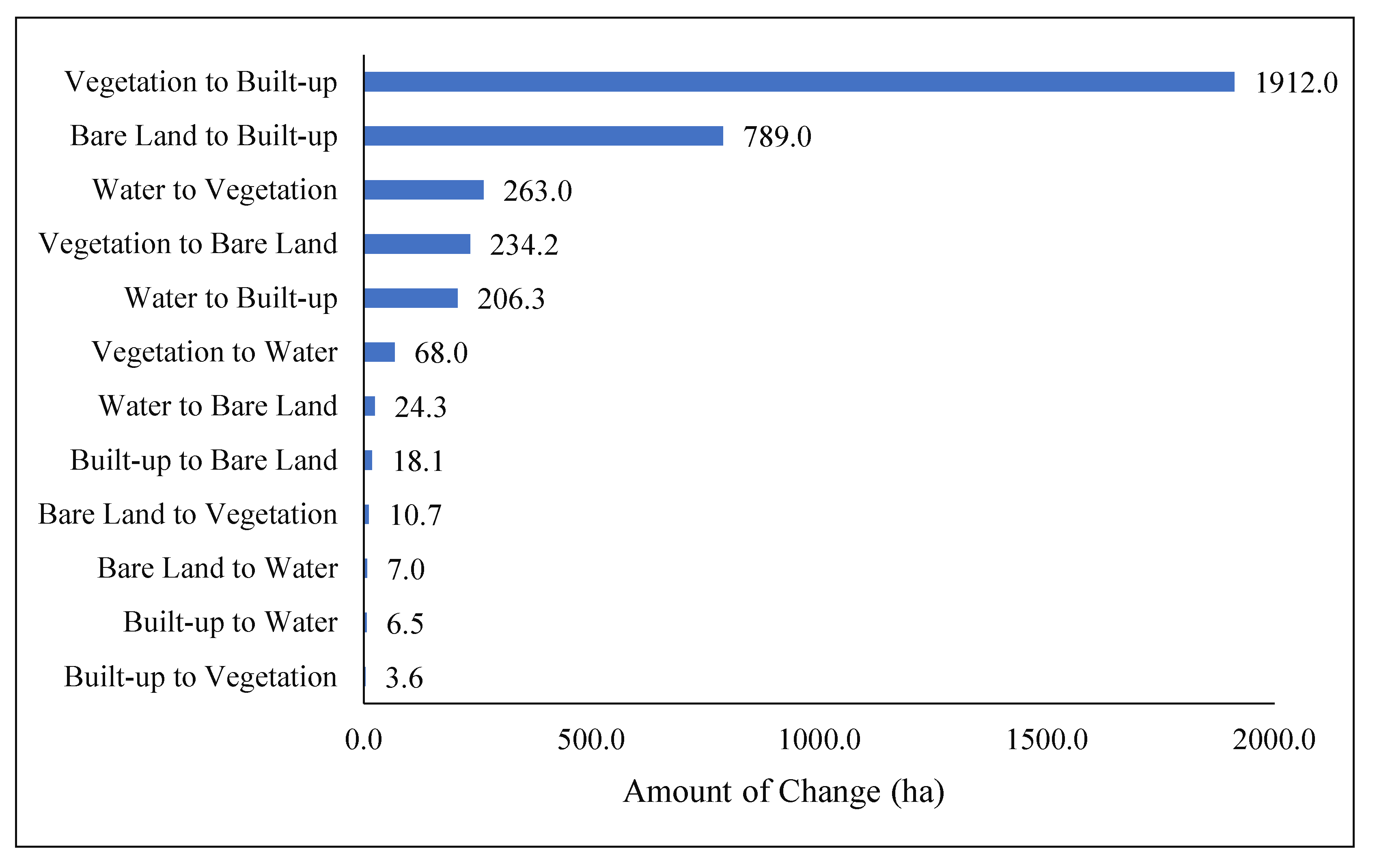
Change detection analysis reveals that, between 2003 and 2023, all the four land cover classes lost and gained land from each other (see Figure 8). As expected, the largest change, amounting to 1,912 hectares, was from vegetation to built-up area, followed by bare land to built-up area (789 hectares). Overall, the built-up area gained 2,907.4 hectares and lost only 28.24 hectares while vegetation gained only 2,77.3 hectares and lost 2,214.2 hectares. Also, water lost 493.7 hectares and gained only 81.5 hectares. In summary, most of the natural landcover (vegetation and water) at the Ramsar site has been lost to urban growth (built-up area), which has serious implications for environmental sustainability.
Figure 8.
Landcover Change Detection between 2003 and 2023. Source: Authors’ construct
Figure 8.
Landcover Change Detection between 2003 and 2023. Source: Authors’ construct
4.2. Magnitude and Trend Of Building Coverage
The preceding sub-section has shed light on the extent to which natural landcover has been indiscriminately built up during the last 20 years. This and subsequent sections provide a close-view analysis of the magnitude and spatial patterns of building construction, which makes up most of the built-up area, and how these have changed over the last 10 years (2013-2023).
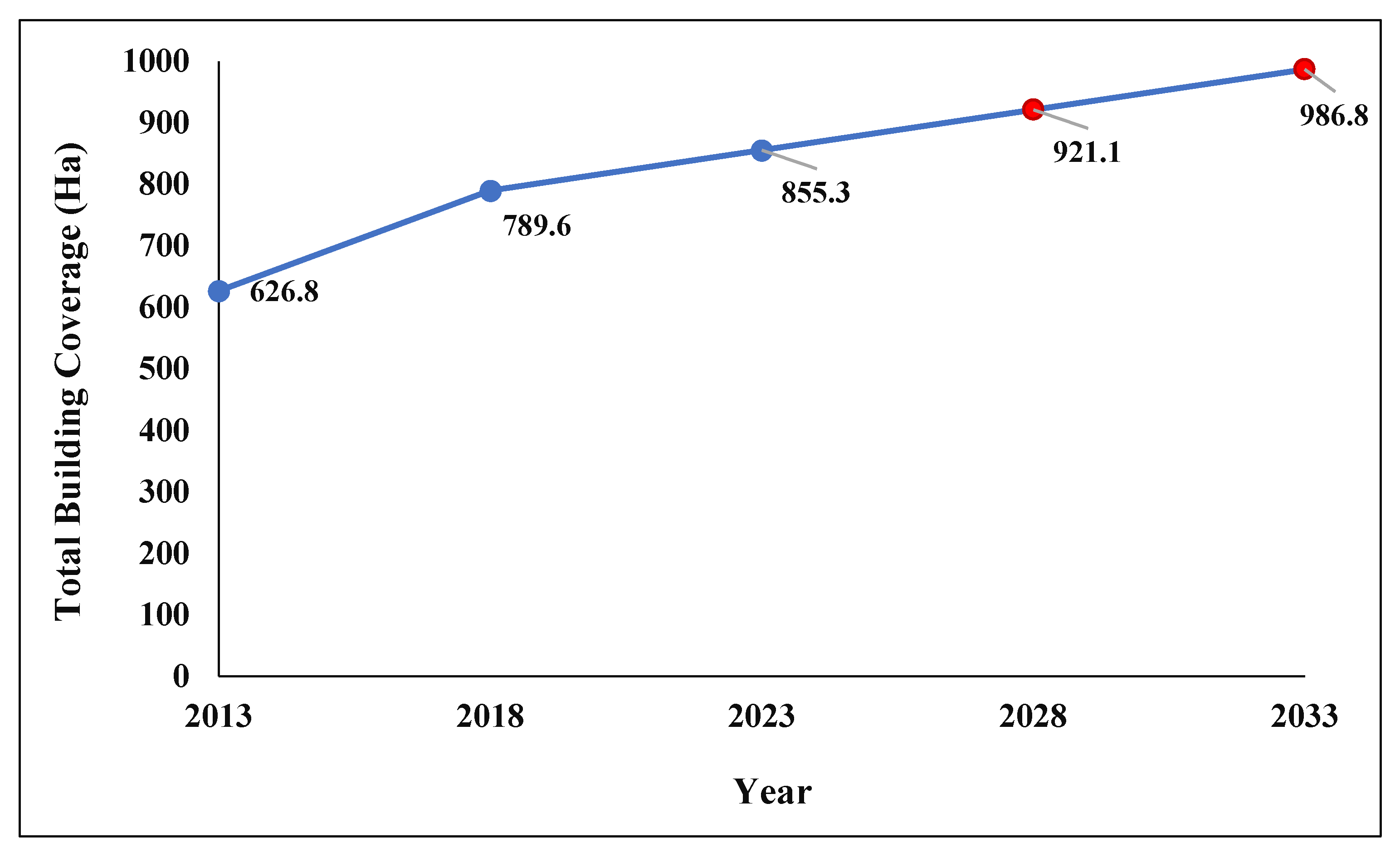
The data show considerable growth in the number of buildings and building coverage between 2013-2023. In 2013, the site had 43,243 buildings, which increased to 45,659 in 2018 and 46,850 in 2023, representing an overall increase of 8.3% between 2013-2023. As Figure 9 shows, this translated into growth in total building coverage (land take) from 626.8 hectares (or 10.6% of the total area of the study site) in 2013 to 789.6 hectares (or 13.4%) and 855.3 hectares (or 14.5%) in 2018 and 2023, respectively. It also means that building coverage growth rate rose from 32.6 hectares per annum between 2013-2018 to 13.15 hectares per annum between 2018-2023. At the 2018-2023 growth rate, the total building coverage is projected to reach 986.8 hectares by 2032 if measures are not taken to slow physical development.
Figure 9.
Total Building Coverage, 2013-2032. Source: Authors’ construct.
Figure 9.
Total Building Coverage, 2013-2032. Source: Authors’ construct.
The field data show that the buildings constructed at the site were predominantly residential structures. Out of the 163 randomly selected buildings directly observed on the field as part of the ground-truthing, as many as 144 (or 88%) were residential structures. In comparison, the remaining 12% included churches and mosques, school buildings and commercial buildings. Also, building construction occurred on both dry ground and at locations where the landscape is low-lying, waterlogged and highly flood-prone. For instance, at Glefe, one of the flood-prone communities, land was being reclaimed from Lagoons and marshes for building construction.
4.3. Spatial Pattern of Building Coverage
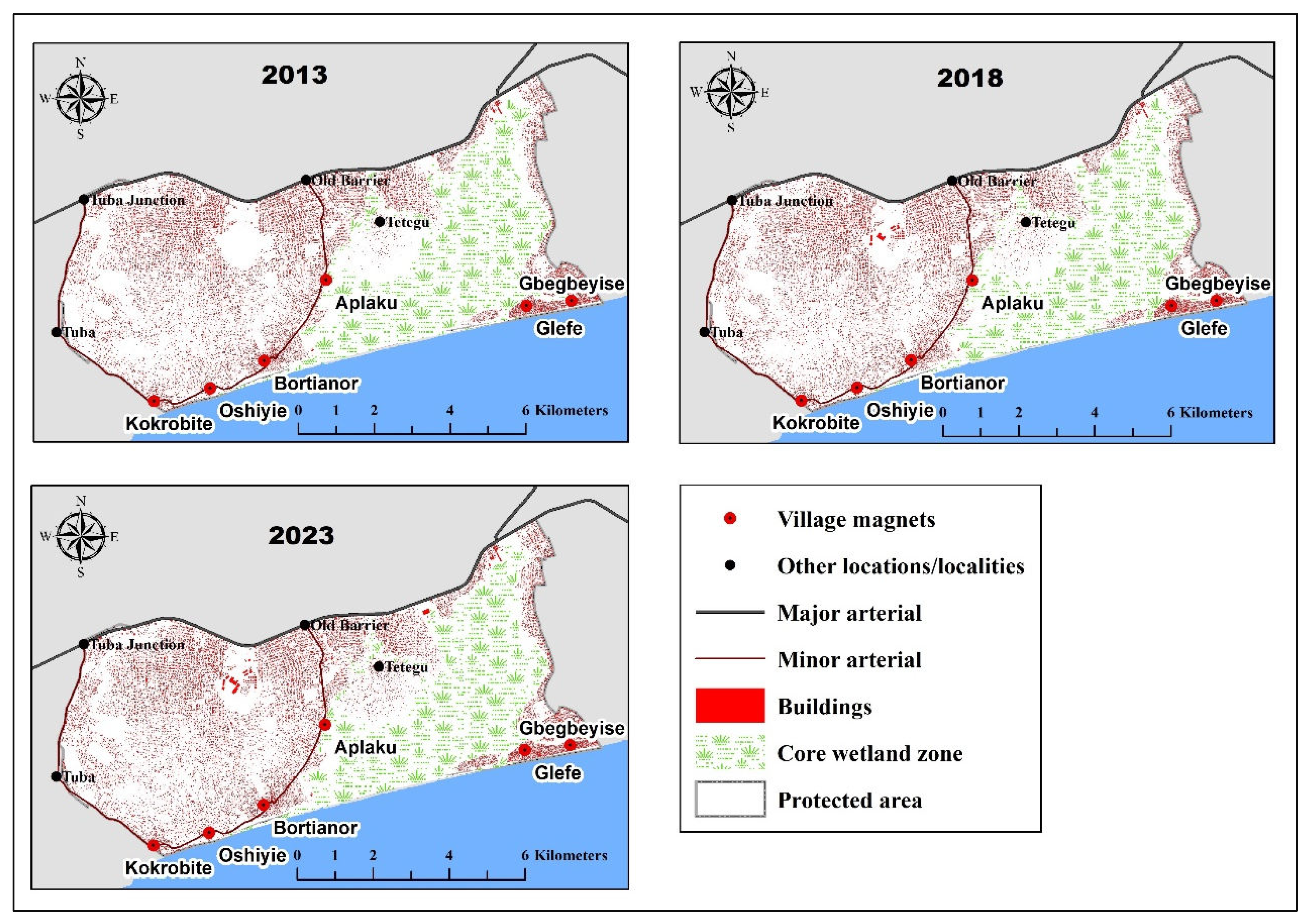
Visual examination of the spatial distribution of buildings shows that, between 2013-2023, building construction was more concentrated at specific locations than others. Locations with exceptionally high concentrations included the eastern edge of the study site, which happens to be closest to Accra. High concentrations were also recorded around Glefe, Gbegbeyise and the other village magnets and along the arterial roads. Areas of low concentration included the southwestern portion of the site and areas immediately surrounding the wetland core (see Figure 10).
Figure 10.
Spatial Pattern of Buildings, 2013-2023.Source: Authors’ construct.
Figure 10.
Spatial Pattern of Buildings, 2013-2023.Source: Authors’ construct.
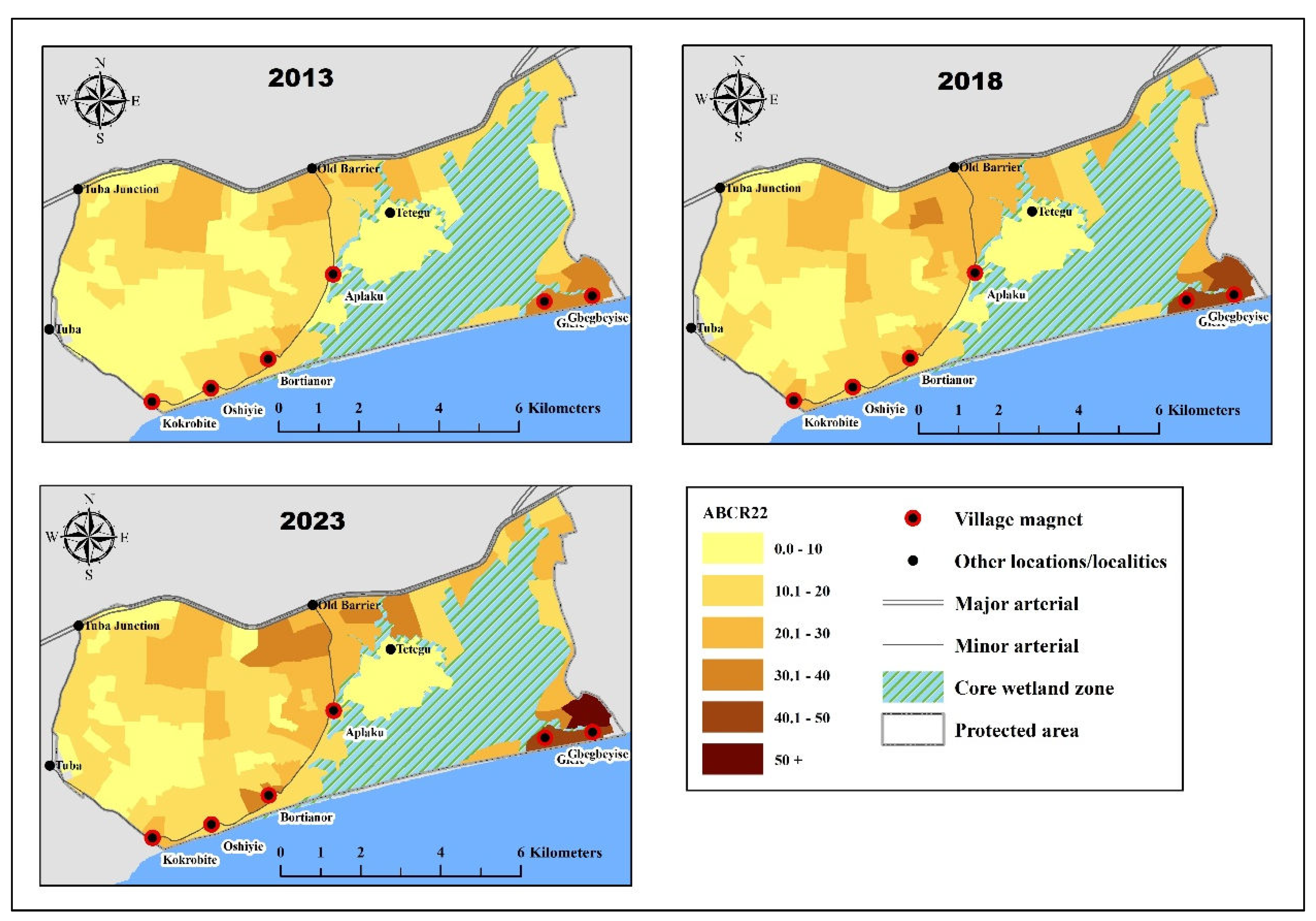
The spatial patterns of building coverage described above were confirmed by analysis of ABCR patterns. From 2013 to 2023, ABCRs were persistently high in sectors within the corridors of the major and minor arterial roads, except those located along the Kokrobite-Tuba Junction stretch of the minor arterial, where there was little building construction (see Figure 11). For instance, in 2023, seven (7) out of the ten sectors with the highest ABCRs (ranging from 29.3 to 53.1) either abutted or were located within one kilometre of a major or minor arterial. In addition, the ABCRs of sectors located within the immediate environs of the six village magnets were relatively high, with the top three sectors (with ABCRs of 37.6, 50.0 and 53.1, respectively) being located within the Glefe-Gbegbeyise enclave. Overall, sectors along the eastern boundary of the study site (i.e. those closest to Accra) recorded a mean ABCR of 30.5 in 2023, compared to the overall mean of 21.5.
Figure 11.
Spatial Pattern of ABCRs, 2013-2023.Source: Authors’ construct.
Figure 11.
Spatial Pattern of ABCRs, 2013-2023.Source: Authors’ construct.
4.4. Growth in Building Coverage
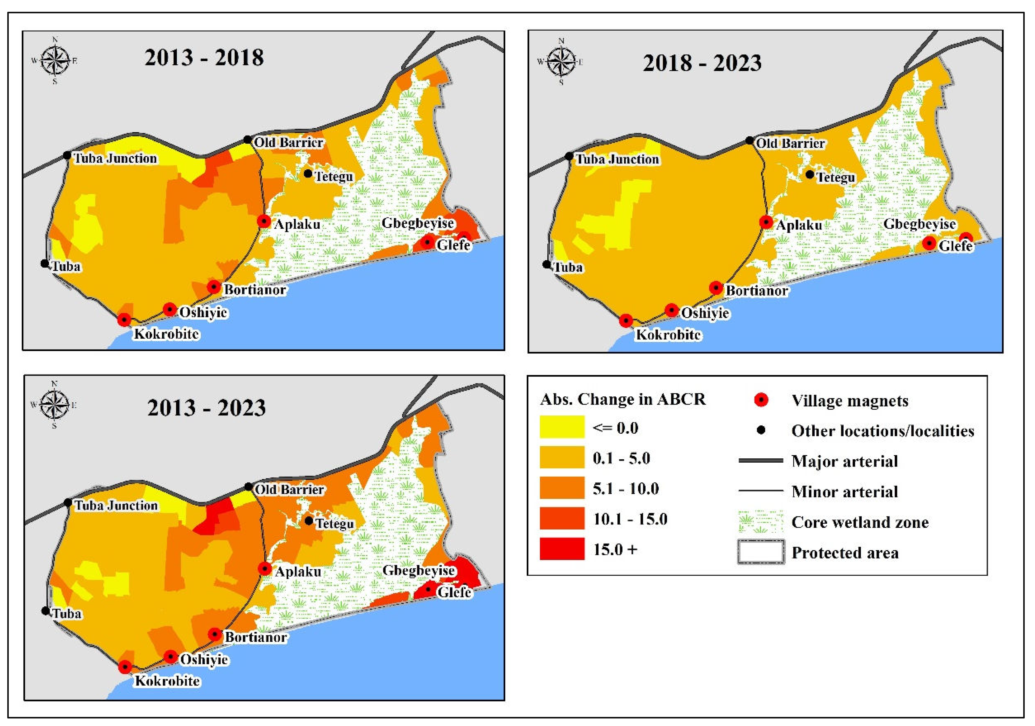
Between 2013 and 2023, about 92.2% of the 102 sectors recorded positive growth in ABCR, while the remaining 7.8% recorded either zero or negative growth. However, most of the growth occurred between 2013-2018, during which period the average sector recorded an ABCR change of 27.9%, compared to the 2018-2023 period, when the corresponding change was only 8.1%. This was because the rate of building construction slowed down during the latter period.
As Figure 12 shows, the absolute increase was more significant in sectors located along the segment of the major arterial east of Old Barrier and the Old Barrier-Kokrobite stretch of the minor arterial, as well as those located around village magnets or near Accra. The fact that sectors with the highest ABCRs in 2013 recorded the most significant increase in ABCR means that, between 2013-2023, already built-up sectors experienced considerable consolidation and in-fill development in building construction.
Figure 12.
Absolute Change in ABCR, 2013-2023.Source: Authors’ construct.
Figure 12.
Absolute Change in ABCR, 2013-2023.Source: Authors’ construct.
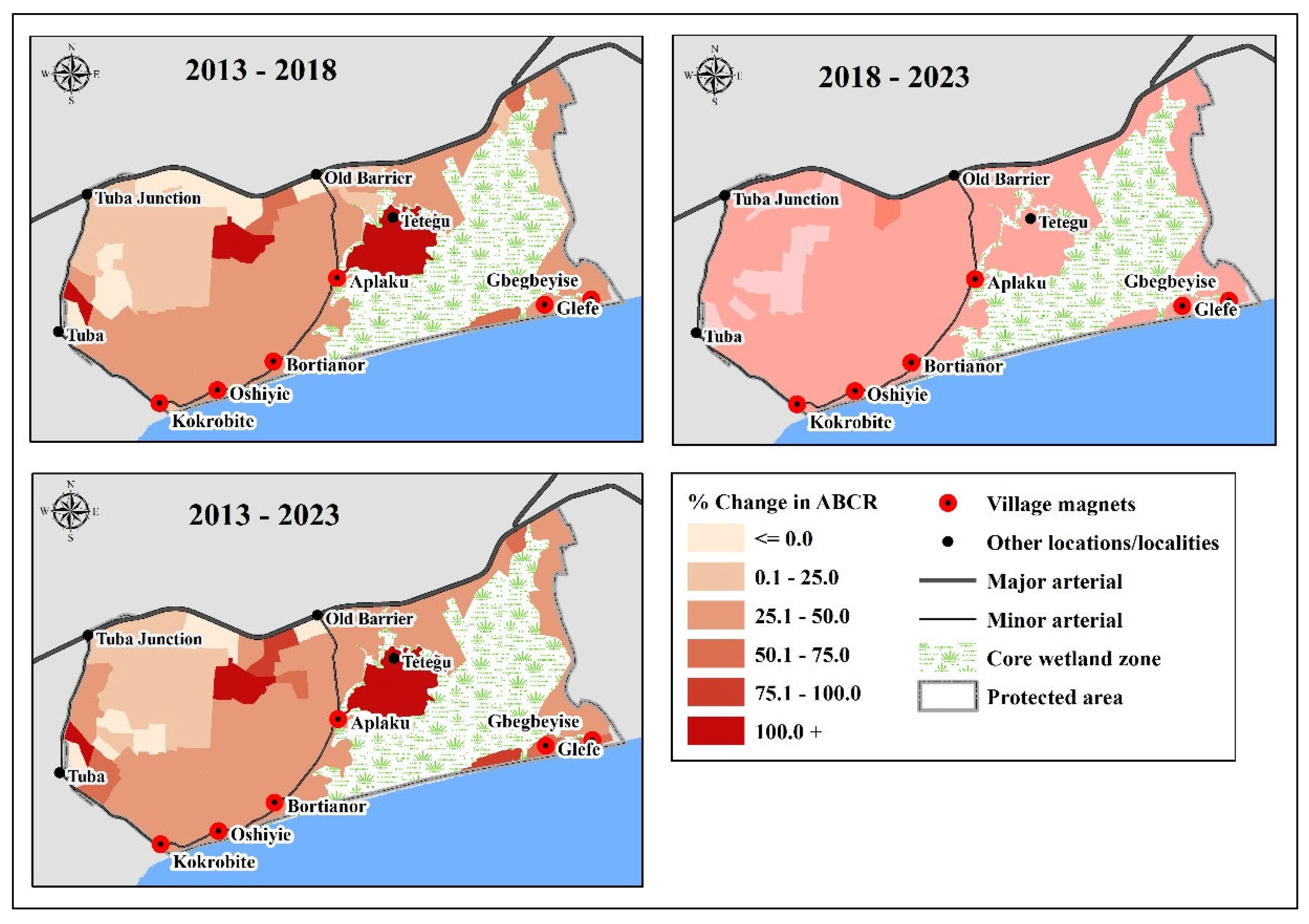
While the spatial distribution of absolute ABCR change showed clear patterns, relative ABCR change was substantially uniform, with 67 out of the 102 sectors recording a 25-50% increase. As Figure 13 shows, there was a slight spatial variation in percentage growth in ABCR between 2013 and 2023, except in the western end of the study site and areas along the Old Barrier-Tuba Junction stretch of the major arterial where nine sectors recorded between -35.3% and 0.8% change. The relatively slow pace of ABCR growth in the western end of the study site could partly be attributed to the hilly terrain. This part of the study area also included a 40-hectare protected farmland (near the village of Tuba), forming part of the Tuba Irrigation Scheme. It is also significant to note that Glefe, Gbegbeyise and Tetegu communities, together with their immediate environs, where the landscape is low-lying, waterlogged and highly flood-prone, experienced almost the same amount of relative ABCR growth as other locations.
Figure 13.
Percentage Change in ABCRs.Source: Authors’ construct.
Figure 13.
Percentage Change in ABCRs.Source: Authors’ construct.
4.5. Statistical Significance of the Effects of Growth Drivers
Data presented under the preceding sub-sections suggest, rather descriptively, that the hypothesised growth drivers (i.e. proximity to Accra, arterial roads and village magnets) influenced the spatial pattern and growth of building coverage at the study site. This sub-section presents the results of OLS regression and SAR models to ascertain the statistical significance of these revelations. As indicated earlier, the SAR technique was used to assess the effects of the growth drivers on the spatial distribution of ABCRs, while OLS regression was used to assess their effects on ABCR changes.
4.5.1. Effects on the Spatial Distribution of ABCRs (SAR Models)
The results in Table 4 show that ACC2, VILL and ROAD1 significantly influenced the spatial patterns of ABCRs throughout the period 2013-2023. For instance, ABCRs were higher in sectors close to Accra (ACC2) than those located farther away from the city. In other words, as suggested by the spreading pancake hypothesis, the SAR models show that distance from Accra negatively impacted ABCR values, after accounting for spatial autocorrelation and the effects of other growth drivers. Similarly, sectors located within 1km of a village magnet (VILL) or the N1 highway (ROAD1) recorded higher ABCRs than those located elsewhere. That is, in consonance with the village magnet and ribbon development hypotheses, proximity to the five village magnets and the N1 highway positively impacted ABCRs, even after accounting for spatial autocorrelation and proximity to Accra. However, the effects of ROAD2 and ELEV were found to be statistically insignificant as their p-values exceeded the 5% alpha level.
Table 4.
Spatial Autoregressive (SAR) Models of ABCR.
Table 4.
Spatial Autoregressive (SAR) Models of ABCR.
| Predictors |
Model 1
(y = ABCR12)
|
|
Model 2
(y = ABCR17)
|
|
Model 3
(y = ABCR22)
|
| |
Coefficient |
Std. err. |
|
Coefficient |
Std. err. |
|
Coefficient |
Std. err. |
|
13.086*** |
2.297 |
|
18.448*** |
2.772 |
|
20.662*** |
3.008 |
| ACC2 |
-0.020*** |
0.008 |
|
-0.032*** |
0.009 |
|
-0.037*** |
0.010 |
| VILL |
3.886* |
2.084 |
|
5.343** |
2.420 |
|
5.835** |
2.599 |
| ROAD1 |
4.539*** |
1.732 |
|
4.681** |
1.976 |
|
4.864** |
2.115 |
| ROAD2 |
-1.305 |
1.777 |
|
-1.707 |
2.102 |
|
-1.617 |
2.275 |
| ELEV |
-0.965 |
1.560 |
|
-2.057 |
1.780 |
|
-2.399 |
1.905 |
|
0.283** |
0.139 |
|
0.270** |
0.136 |
|
0.257* |
0.137 |
|
0.444* |
0.253 |
|
0.428 |
0.275 |
|
0.429 |
0.279 |
| Wald test of spatial terms [chi2(2)] |
17.1*** |
-- |
|
13.5*** |
-- |
|
12.4*** |
-- |
| Pseudo R2
|
0.289 |
-- |
|
0.379 |
-- |
|
0.406 |
-- |
| Wald chi2(6) |
37.650*** |
-- |
|
55.020*** |
-- |
|
60.210*** |
-- |
| Number of observations |
102 |
|
|
102 |
|
|
102 |
|
4.5.2. Effects on ABCR Change (OLS Regression)
Table 5 shows the influence of ACC2, VILL, ROAD1 and ROAD2 on changes in ABCR between 2013-2018 (Model 1), 2018-2023 (Model 2) and 2013-2023 (Model 3) after controlling for terrain and base-year ABCRs. It shows a significant negative relationship between ABCR change and distance from Accra (ACC2) in all three periods. That is, in line with the spreading pancake hypothesis, sectors closer to Accra registered higher amounts of absolute growth in ABCR than those located farther away. During the period 2018-2023, sectors located within 1km of the N1 highway (ROAD1) registered lower amounts of absolute growth in ABCR than those located more than 1km away. This was probably because sectors within the immediate vicinity of the highway were nearing the point of saturation, so building construction had slowed down there. The data also show that sectors with elevations (ELEV) exceeding 50m above sea level registered lower absolute growth in ABCR than those on lower grounds. However, proximity to the village magnets (VILL) and the minor arterial (ROAD2) had no statistically significant influence on ABCR change.
Table 5.
Ordinary Least Square (OLS) Regression Models of ABCR Change.
Table 5.
Ordinary Least Square (OLS) Regression Models of ABCR Change.
| Predictors |
Model 1
(y = CHANGE1)
|
|
Model 2
(y = CHANGE2)
|
|
Model 3
(y = CHANGE3)
|
| |
Coefficient |
Std. err. |
|
Coefficient |
Std. err. |
|
Coefficient |
Std. err. |
|
4.865*** |
0.910 |
|
1.058*** |
0.251 |
|
6.518*** |
1.139 |
| ACC2 |
-0.011*** |
0.003 |
|
-0.003*** |
0.001 |
|
-0.016*** |
0.003 |
| VILL |
0.693 |
0.742 |
|
0.028 |
0.190 |
|
0.862 |
0.929 |
| ROAD1 |
-0.873 |
0.612 |
|
-0.321** |
0.153 |
|
-1.137 |
0.766 |
| ROAD2 |
0.179 |
0.589 |
|
0.280* |
0.150 |
|
0.453 |
0.737 |
| ELEV |
-1.255*** |
0.493 |
|
-0.329*** |
0.126 |
|
-1.656*** |
0.617 |
| ABCR13 |
0.101*** |
0.035 |
|
-- |
-- |
|
0.156*** |
0.044 |
| ABCR18 |
-- |
-- |
|
0.067*** |
0.008 |
|
-- |
-- |
| R2
|
0.4892 |
-- |
|
0.7434 |
-- |
|
0.5482 |
-- |
| Adjusted R2
|
0.4570 |
-- |
|
0.7272 |
-- |
|
0.5196 |
-- |
| F-test (6, 95) |
15.17 |
-- |
|
45.87 |
-- |
|
19.21 |
-- |
| p-value |
0.000 |
-- |
|
0.000 |
-- |
|
0.000 |
-- |
| No. of observations |
102 |
-- |
|
102 |
-- |
|
102 |
-- |
4.6. Institutional Response To Urban Growth at the Ramsar Site
Ghana has established a policy framework and institutional arrangements for protecting wetlands in line with its signing up to the Ramsar Convention on Wetlands. However, the fact that physical development continues at the study site suggests that the government’s wetland protection measures are either not enforced or ineffective. Key informant interviews revealed several bottlenecks that constrain the capacity of the responsible institutions to play their wetland protection roles. First, the interviews revealed inadequate coordination and collaboration among the key state institutions (such as the Municipal Assembly, the Wildlife Division and the Environmental Protection Agency) responsible for wetland protection.
Secondly, the interview revealed a lack of cooperation from political leaders, chiefs and other customary landowners, which discourages technocrats from enforcing land use control and wetland protection measures. For instance, respondents complained that political leaders lack the will to enforce land use control regulations and that some of them protect developers who encroach on wetlands by interfering with public officials who attempt to enforce the law. For example, in the Ga South Municipal Assembly, one official stated that “sometimes when a developer decides to put up a building on a reserved land and public officials attempt to demolish it, they are prevented by politicians from doing their work” (Public Official 1, 2023) Also, customary landowners such as chiefs and family heads were accused of disregarding wetland protection policies and zoning regulations by demarcating and allocating building plots in wetlands to developers.
Thirdly, the respondents claimed that the wetland protection institutions lacked adequate human resource, transport, and logistical capacity. For instance, one respondent mentioned that conservationists, planners and development control officers were handicapped by lack of vehicles and staff to undertake field monitoring activities at the protected site. Consequently, these institutions appear overwhelmed by the enormity of spontaneous physical development at the site.
5. Discussion
5.1. Loss of Natural Landcover To Uncontrolled Urban Growth
The results presented above show clearly that urban growth at the Densu Delta Ramsar site is environmentally unsustainable. This is manifest in the massive loss of vegetative cover to the built-up area, which has come as a result of uncontrolled construction of buildings, infrastructure and other infrastructure to meet the needs of Accra’s rapidly-growing population. For instance, building count and coverage grew steadily between 2013-2023, and this occurred both on dry ground and at locations where the landscape is low-lying, waterlogged and highly flood-prone. The findings in the current study are consistent with earlier ones by [
38] who reported of widespread illegal building encroachments, wetland drainage, deforestation, ecosystem degradation, pollution from indiscriminate waste disposal and biodiversity loss at the site, all due to uncontrolled urban growth.
Building coverage at the site is expected to increase by 57% in the next decade at the current growth rate. Most of this growth will occur as in-fill development within the existing built-up area, but will also involve further encroachments on the remnants of natural landcover. This will lead to further deterioration and loss of the wetlands and heightened residents' exposure to the risk of environmental hazards such as flooding. Also, the fact that almost nine in 10 buildings are residential structures suggests that demand for dwelling space for the spillover population from Accra is a major socio-economic force driving urban growth at the study site. Therefore, the achievement of SDG 11 (sustainable cities and communities) will be undermined if drastic measures are not taken to check urban growth at the site.
5.2. Effects of Growth Drivers
The study has also shown that urban growth at the study site follows some discernible patterns consistent with the spreading pancake, village magnet and ribbon development models [
28]. In line with the spreading pancake model, sectors located near Accra had significantly higher concentrations of building counts and building coverage than those located farther away. These findings can be attributed to the fact that physical development at the study site results from the unchecked horizontal spread of the contiguously built-up area of Accra, a common phenomenon in low-income metropolitan areas [
29]. In addition, the data show that sectors close to the city registered greater amounts of growth in building coverage between 2013-2023 than those located farther away. In other words, there was a negative relationship between the magnitude of change in building coverage (ABCR) and distance from Accra. This is because horizontal spread involves leapfrog development at the initial stages, but over time, densification is achieved through infill development. However, this kind of infill development is more of an organic process than a consciously planned land-use-optimisation strategy [
18].
The data also reveal that the general distance-decay feature of the spreading-pancake pattern of urban growth was punctuated by pockets of village-magnets where physical development was relatively dense. As has been pointed out, peri-urban villages close to large cities tend to attract urban residents seeking cheap land for housing construction, leading to pockets of relatively fast and dense growth surrounded by slow and sparse growth [
28]. The presence of this phenomenon at the study site was evidenced by the fact that sectors located near Bortianor, Kokrobite, Oshieyie, Aplaku, Gbegbeyise and Glefe recorded significantly higher concentrations of both building counts and building coverage than those located elsewhere. However, the data show that the effect of the village magnets on the spatial distribution of physical development disappeared over time as development became ubiquitous. This was demonstrated by the fact that, although proximity to the six village magnets influenced the spatial concentration of building coverage, it had no significant effect on the change in building coverage during the period under consideration (2013-2023).
The data also show clearly that the effect of transportation infrastructure on urban growth, as observed by several authors [
29,
32,
46], played out at the study site. Sectors located near the N1 highway registered higher concentrations of building counts and coverage than those located farther away. This is consistent with the ribbon development model, which suggests that the horizontal spread of the built-up area of a metropolitan area occurs axially along transportation corridors [
18,
28,
32,
46]. For instance, George Owusu observed that upgrading the N1 and other highways connecting Accra to the rest of the country to multi-lane dual-carriage roads had contributed to sprawl development along these roads' corridors, including the study site [
46]. However, while confirming these earlier findings in part, the current study also shows that the relatively high concentration of physical development within road corridors diminishes over time. According to our data, there was a negative correlation between proximity to the N1 highway and the
change in building coverage between 2013-2023. That is, although sectors located within 1km of the highway initially registered relatively high concentrations of buildings, these sectors registered lower amounts of new buildings constructed during the period than elsewhere. This was because development spread outward from the highway as the road corridor got saturated.
In summary, the magnitude, speed and pattern of urban growth are driven by factors such as proximity to a central city, highways and pre-existing peri-urban villages. These factors are so influential that their presence is enough to attract physical development to ecologically-sensitive areas such as wetlands, even when such sites pose hazards like flooding. Therefore, the presence of these growth drivers cannot be ignored when devising policies and strategies to protect wetlands and other ecological assets.
5.3. Institutional Failure And Implications for Environmental Sustainability
To a large extent, the potency of proximity to Accra, village magnets and the N1 highway in driving urban growth played out at the study site almost unhindered due to the failure of state institutions to control and regulate physical development. This failure has been attributed to inadequate institutional coordination and collaboration and a lack of political will to support and resource these institutions to perform their land use control and wetland protection functions. This confirms other studies that found poor governance and weak institutions responsible for the failure to effectively manage Africa’s urban environment [
47,
48,
49]. For instance, in Kumasi, Ghana, responsible state agencies have failed to effectively enforce existing regulations and laws designed to protect wetlands, which has been attributed to a lack of political commitment, low capacity and poor institutional coordination [
47].
Continual urban growth at the study site amid institutional failure to control physical development has dire consequences for environmental sustainability. In particular, the reclamation of land from the core wetlands (including lagoons and marshes) for building construction and the generally widespread physical development in low-lying areas will not only lead to the loss of ecosystem benefits of wetlands but also increased frequency and scale of flooding and other environmental hazards. Therefore, there is an urgent need to tackle the problem of wetland loss resulting from uncontrolled urban growth from a governance and institutional perspective. In other words, effective governance should be seen as the bedrock upon which environmental sustainability and other pillars of sustainable urban development stand.
6. Conclusions
This study sought to add to existing knowledge on how uncontrolled physical development contributes to the loss of wetlands by analysing the morphological patterns and drivers of urban growth at the Densu Delta Ramsar site. The findings show that urban growth at the site follows discernible morphological patterns that are consistent with the spreading pancake, village magnet and ribbon development models. These patterns are created by the growing demand for land for building construction to meet the housing and infrastructural needs of Accra’s growing population, proximity of the site to Accra, as well as the presence of the NI highway and pre-existing peri-urban villages. The presence of these factors, amid the failure of responsible state institutions to perform their land use control and wetland protection functions, has led to massive encroachments on the Ramsar site. Unless drastic measures are taken to curb further physical development, the loss of ecosystem benefits of wetlands, increased frequency and scale of flooding, and other dire environmental consequences are bound to get worse.
In addition, the study has demonstrated the utility of aggregate building coverage ratios based on high-resolution satellite images in combination with the often-used land use/land cover method in the spatiotemporal analysis of urban growth. The main strength of the aggregate building coverage ratio method is that it considers the intensity of physical development and also allows for formal empirical testing of urban growth models such as the spreading pancake, village magnet and ribbon development models.
To achieve sustainable urban development and thus contribute to the UN’s Sustainable Development Goal 11 (sustainable cities and communities), there is an urgent need to ensure effective wetland management by enforcing land use, development control and wetland protection measures. This calls for the strengthening, resourcing and closer collaboration between the various state agencies responsible for wetland management. There is also the need to engage and sensitise political leaders to increase their commitment to implementing wetland protection and pro-environmental policies.
Author Contributions
conceptualization, C.Y.O. and P.A.A.; methodology, C.Y.O. and M.N.; formal analysis, C.Y.O. and M.N.; investigation, C.Y.O., P.A.A. and M.N.; data curation, C.Y.O.; writing—original draft preparation, C.Y.O. and M.N.; writing—review and editing, P.A.A.; project administration, C.Y.O. All authors have read and agreed to the published version of the manuscript.
Funding
Please add: This research received no external funding.
Institutional Review Board Statement
“The study was conducted in accordance with the Declaration of Helsinki, and approved by the Institutional Review Board (or Ethics Committee) of Kwame Nkrumah university of Science & Technology, Kumasi, Ghana.
Informed Consent Statement
Informed consent was obtained from all subjects involved in the study.
Data Availability Statement
The original data presented in the study are openly available at:
USGS EarthExplorer (
https://earthexplorer.usgs.gov/) for the Landsat images used in LULC analysis and
Google Earth Pro for the high-resolution satellite images used building coverage analysis.
Acknowledgments
In this section, you can acknowledge any support given which is not covered by the author contribution or funding sections. This may include administrative and technical support, or donations in kind (e.g., materials used for experiments).
Conflicts of Interest
The authors declare no conflicts of interest.
References
- UN Department of Economic and Social Affairs. The World’s Cities in 2018—Data Booklet (ST/ESA/ SER.A/417). New York: United Nations; 2018.
- Forget Y, Shimoni M, Gilbert M, Linard C. Mapping 20 years of urban expansion in 45 urban areas of sub-Saharan Africa. Remote Sens 2021;13:1–19. [CrossRef]
- Dos Santos S, Adams EA, Neville G, Wada Y, Sherbinin A De, Bernhardt EM, et al. Urban growth and water access in sub-Saharan Africa: Progress, challenges, and emerging research directions. Sci Total Environ 2017;607–608:497–508. [CrossRef]
- Oduro CY. Effects of Rapid Urbanization on Livelihoods in the Peri-Urban Areas of Accra, Ghana. Florida State University, Tallahassee FL, USA, 2010.
- Abdullahi S, Pradhan B, Al-sharif AAA. Introduction to urban growth and expansion. In: Pradhan B, editor. Spatial Modeling and Assessment of Urban Form: Analysis of Urban Growth: From Sprawl to Compact Using Geospatial Data, Cham: Springer International Publishing AG; 2017, p. 3–16. [CrossRef]
- Amoateng P, Cobbinah PB, Owusu-Adade K. Managing physical development in peri-urban areas of Kumasi, Ghana: A case of Abuakwa. J Urban Environ Eng 2013;7:96–109. [CrossRef]
- Aguilar AG, Flores MA, Lara LF. Peri-urbanization and land use fragmentation in Mexico City: Informality, environmental deterioration, and ineffective urban policy. Front Sustainable Cities 2022;4:1–19. [CrossRef]
- Asamoah RO, Nelson IDI, Twumasi-Ampofo K, Solomon-Ayeh B, Offei-Nyako K, Ankrah JS. Invasion of wetlands in Kumasi by informal economic activities and consequences for urban management. Urban Reg Plan 2016;1:16–21. [CrossRef]
- Campion BB, Owusu-Boateng G. The political ecology of wetlands in Kumasi , Ghana. Int J Environ Bioenergy 2013;7:108–28.
- Kanaujia A, Kumar A. Wetlands : Significance , threats and their conservation. Green 2014;7.
- Ramsar Convention Secretariat. An Introduction to the Ramsar Convention on Wetlands, 7th ed. Gland, Switzerland: Ramsar Convention Secretariat; 2016.
- Yepsen M, Baldwin AH, Whigham DF, Mcfarland E, Laforgia M, Lang M. Agricultural wetland restorations on the USA Atlantic Coastal Plain achieve diverse native wetland plant communities but differ from natural wetlands. Agric Ecosyst Environ 2014:11–20. [CrossRef]
- Costanza R, D’Arge R, de Groot R, Farber S, Grasso M, Hannon B, et al. The value of the world ’ s ecosystem services and natural capital. Nat 1997;387:253–60. [CrossRef]
- Dodds WK, Wilson KC, Rehmeier RL, Knight GL, Wiggam S, Falke JA, et al. Comparing ecosystem goods and services provided by restored and native lands. BioSci 2008;58:837–45. [CrossRef]
- Wright T, Tomlinson J, Schueler T, Cappiella K, Kitchell A, Hirschman D. Article 1: Direct and indirect impacts of urbanization on wetland quality. Wetlands & Watersheds Article Series #1 2006.
- WWT Consulting. Good Practices Handbook for Integrating Urban Development and Wetland Conservation. Slimbridge, UK: WWT Consulting; 2018.
- Kometa SS, Kimengsi JN, Petiangma DM. Urban development and its implications on wetland ecosystem services in Ndop, Cameroon. Environ Manage Sustainable Dev 2018;7:21–36. [CrossRef]
- Oduro CY, Ocloo K, Peprah C. Analysing growth patterns of Greater Kumasi Metropolitan Area using GIS and multiple regression techniques. J Sustainable Dev 2014;7:13–31. [CrossRef]
- Quezada CR, Jorquera F. Urban fabrics to eco-friendly blue–green for urban wetland development. Sustainability (Switzerland) 2021;13. [CrossRef]
- Cai Y, Zhang H, Pan W. Detecting urban growth patterns and wetland conversion processes in a natural wetlands distribution area. Polish J Environ Stud 2015;24:25–35. [CrossRef]
- Ritchie H, Roser M. Urbanization. OurWorldInData 2018.
- Ghana Statistical Service. 2000 Population and Housing Census: Volume 2 (Policy Implications of Population Trends Data). Accr: Ghana Statistical Service; 2005.
- Ghana Statistical Service. 2000 Population and Housing Census: Volume 1 (Socio-Economic and Demographic Trends Analysis). Accra: Ghana Statistical Service; 2005.
- Ghana Statistical Service. 2010 Population and Housing Census: Urbanisation. Accra: Ghana Statistical Service; 2014.
- Ghana Statistical Service. Ghana 2021 Population and Housing Census: Volume 3A (Population of Regions and Districts). Accra: Ghana Statistical Service; 2021.
- Ghana Statistical Service. Ghana 2021 Population and Housing Census: Volume 4 (Thematic Report on Migration). Accra: Ghana Statistical Service; 2023.
- Weable C. Analysis of urbanization patterns in the Densu Delta and surrounding areas (Accra, Ghana): An interdisciplinary approach combining remote sensing and human geography methods. Trier: 2019.
- Doan P, Oduro CY. Patterns of population growth in peri-urban Accra , Ghana. Int J Urban Reg Res 2012;36:1306–25. [CrossRef]
- Lall S, Lebrand M, Park H, Sturm D, Venables A. City Form to Promote Sustainable Growth. Washington, DC: The World Bank; 2021.
- Linard C, Tatem AJ, Gilbert M. Modelling spatial patterns of urban growth in Africa. Appl Geogr 2013;44:23–32. [CrossRef]
- Arribas-Bel D, Sanz-Gracia F. The validity of the monocentric city model in a polycentric age: US metropolitan areas in 1990 , 2000 and 2010. Urban Geogr 2014;35:980–97. [CrossRef]
- Glaeser EL. Infrastructure and urban form. Cambridge, MA: 2020.
- Yang J, Zhou J. Shenzhen , China Rail + Property for Development. In: Mehrotra S, Lewis L, Orloff M, Olberding B, editors. Greater Than Parts: A Metropolitan Opportunity, Volume II, Washington, DC: World Bank; 2020.
- Gough K, Yankson P. Conflict and cooperation in environmental management in peri-urban Accra. In: McGregor D, Simon D, Thompson D, editors. The Peri-Urban Interface: Approaches to Sustainable Natural And Human Resource Use, London: Earthscan; 2006.
- Duranton G, Puga D. Urban Growth and its Aggregate Implications. Cambridge, MA: 2019.
- Addo AA. Assessing Heavy Metal Load of Fish and Shorebirds in The Densu Delta Ramsar Site, Ghana. University of Ghana, Legon, 2017.
- Oteng-Yeboah AA. Development of a management plan for the Densu Delta Ramsar site. Accra: 1999.
- Kondra M. The status of the wetlands in the Greater Accra Region. Trier: 2016.
- Osei J, Osae SK, Fianko JR, Adomako D, Laar C, Anim AK, et al. The impact of Oblogo Landfill Site in Accra-Ghana on the surrounding environment. Res J Environ Earth Sci 2011;3:633–6.
- Tyroller ALC. Changing socio-ecological dynamics in an African peri-urban wetland: The case of the fisheries in the Densu Delta Ramsar site. Trier: 2016.
- USGS EarthExplorer 24AD. https://earthexplorer.usgs.gov/ (accessed March 24, 2024).
- Megayanti T, Widaningsih L, Minggra R, Dewi NIK. Building coverage ratio at the Eastern Corridor of Jalan Ir. H. Djuanda Bandung. IOP Conference Series: Materials Science and Engineering 2018;288. [CrossRef]
- Town and Country Planning Department. Zoning Guidelines and Planning Standards. Accra: Ministery of Environment, Science and Technology; 2011.
- Knief U, Forstmeier W. Violating the normality assumption may be the lesser of two evils. Behav Res Methods 2021;53:2576–90. [CrossRef]
- StataCorp. STATA Spatial Autoregressive Models Reference Manual (for the STATA Release 18 Statistical Software). College Station, TX: StataCorp LLC; 2023.
- Owusu G. Coping with urban sprawl: A critical discussion of the urban containment strategy in a developing country city, Accra. Planum—The J Urbanism 2013;26:1–17.
- Cobbinah PB, Korah PI, Bardoe JB, Darkwah RM, Nunbogu AM. Contested urban spaces in unplanned urbanization: Wetlands under siege. Cities 2022;121:103489. [CrossRef]
- Materu SF, Urban B, Heise S. A critical review of policies and legislation protecting Tanzanian wetlands. Ecosyst Health Sustainability 2018;4:310–20. [CrossRef]
- Mutisya E, Yarime M. Moving towards urban sustainability in Kenya: A framework for integration of environmental, economic, social and governance dimensions. Sustainability Sci 2014;9:205–15. [CrossRef]
|
Disclaimer/Publisher’s Note: The statements, opinions and data contained in all publications are solely those of the individual author(s) and contributor(s) and not of MDPI and/or the editor(s). MDPI and/or the editor(s) disclaim responsibility for any injury to people or property resulting from any ideas, methods, instructions or products referred to in the content. |
© 2024 by the authors. Licensee MDPI, Basel, Switzerland. This article is an open access article distributed under the terms and conditions of the Creative Commons Attribution (CC BY) license (http://creativecommons.org/licenses/by/4.0/).
