1. Introduction
The rapid population growth and urbanization that the cities of the Kingdom of Saudi Arabia have witnessed in recent times have led to significant and clear changes in the forms of their cities, which calls for the creation of sustainable and walkable urban environments. As a result of the increase in urbanization rates, it led to the expansion of cities and the emergence of new challenges related to ease and rapid movement in order to reach quality of life, which was emphasized by the Kingdom of Saudi Arabia’s Vision 2030 [
1,
2]. As a response to these challenges, there has been a growing interest in examining the walkability of urban areas, with a particular focus on attractive sites and street networks and their impact on pedestrian movement and accessibility. The challenges of finding sustainable transportation solutions in urban areas with increasing population density are of critical importance and must be addressed. A core part of the solution lies in highlighting walkability as a key urban design element that can provide benefits across three crucial areas: health, livability, and sustainability [
3,
4]. The Research strongly advocates that the long-term health benefits of walking and physical activity should be a primary incentive to redesign cities to be more walkable and significantly reduce car dependency. This is a vital step in developing sustainable transportation systems for growing urban populations. The Several physical of the built environment must be analysis to facilitate and encourage walkability, such as connectivity, accessibility, proximity to destinations, greenspaces, commercial areas, and proximity to transit [
5,
6].
In broad terms, Walkability is the span to which an urban environment is conducive environment to walking and Wandering activities, and also must provide multifaceted attributes such as the design and layout of streets, the presence of sidewalks pedestrian crossings, the ability to provide of amenities and services within walking distance, and the overall safety and comfort of pedestrians [
5,
6]. Walkable urban cities also work to provide healthy lifestyles and physical activity for residents and develop social interactions, which reduces dependence on cars, which reflects on the environment with a positive and sustainable impact. To achieve walkability, the urban environment must be suitable for walking and the availability of hiking activities. It contains different patterns, such as street design, The designated walking paths, in addition to the proximity of amenities and services within walking distance, and public safety and comfort for pedestrians. [
7,
8].
The idea of walkability and its relationship to metropolitan planning and design has garnered significant attention in recent years. This is no surprise, as walkability emerges as a pivotal urban design element with the power to unlock benefits across three crucial domains: health, sustainability, and livability. At the heart of this rapport is the unparalleled impact of walkable communities on public health. The article persuasively argues that the long-term physical and mental health advantages associated with walking and active lifestyles should be the primary impetus driving efforts to redesign cities to be more walkable [
9]. By reducing reliance on private vehicles, walkable neighborhoods can foster healthier, more physically active populations. Yet the benefits of walkability extend far beyond individual wellbeing. Walkable urban design also serves as a linchpin for sustainable development. By facilitating decreased automobile usage and emissions, walkable cities can make substantial strides toward environmental sustainability goals [
10]. The review highlights the crucial physical elements of the built environment, such as connectivity, accessibility, and proximity to destinations, that enable and encourage walking as a primary mode of transportation [
11,
12]. Moreover, walkable communities deliver enhanced livability for urban residents. Factors like the presence of green spaces, commercial areas, and transit hubs contribute to the overall quality of life and sense of community in walkable neighborhoods. This, in turn, can attract and retain residents, further strengthening the social and economic vitality of the city. Recognizing the multifaceted, symbiotic relationships between walkability, health, sustainability, and livability, this review underscores the urgent need for policymakers and developers to prioritize walkable urban design [
13,
14]. By leveraging various evaluation frameworks and indices, cities can optimize the key elements that foster walkable, healthy, sustainable, and livable communities - a crucial step in addressing the challenges of urban population growth and development.
Furthermore, the use of Geographic Information System (GIS) techniques can achieve the objectives of this study to enhance walkability in Saudi cities and improve urban sustainability through processing the data represents the elements that illustrate the walkability of the city of Onaizah, as well as the street network of the city center, the various uses of land, facilities, and social and demographic impacts and conduct multi criteria decision making analysis to suggest optimal walking corridors associated with urban, commercial and heritage destinations in the city [
15].
During the study of Saudi Vision 2030, which represents a long-term economic and social reform vision for the humanization of Saudi cities announced by the government of the Kingdom of Saudi Arabia in 2016, which gives great attention to developing infrastructure, including transportation, housing, and logistics services, and focuses on demonstrating the human character of cities. Saudi Arabia and interest in health care [
15]. And the extent to which walking can be achieved in a way that reduces the use of cars, which is a major cause of air pollution and greenhouse gas emissions. Walkable cities are also more socially and economically vibrant, because they encourage connectedness between people and support the development of local businesses. Using geographic information systems to create walking corridors leads to the creation of more sustainable and vibrant cities that are more capable of meeting the needs of their residents in a way that is compatible with urban cities that are characterized by rapid urbanization. On the other hand, we find the relationship between spatial formations and human behavior within urban environments. It is achieved by studying the connectivity and integration between street networks, buildings, public, recreational and heritage spaces, and to understand how pedestrian movement, social interactions and perception of space are shaped [
16].
In addition, the Geographic Information System (GIS) helps evaluate walkability factors using spatial data analysis techniques [
17,
18]. The GIS integrates different data layers, including street networks, land use, facilities, and social and demographic information, it also allows for a comprehensive assessment of walkability, producing maps and analyzing various aspects of the urban environment. This provides evidence-based decision-making in the urban planning process, providing meaningful outcomes for improving walkability [
19]. In studying walkability in cities, there is no doubt that urban planning affects the movement and behavior of people within them, which helps city decision-makers and planners determine the most appropriate routes to take [
20,
21,
22].
Based on previous studies that make evaluation to the accessibility of the streets, e.g., Lamíqui. used a method to examine the accessibility of the road network and investigate that the layout of the urban road network can affect pedestrian flow [
23]. This method captures movement patterns influenced by the topology of the road network. Recent studies have incorporated geographic information systems to provide ease and additional data support. Numerous studies have determined street network accessibility by using the GIS and analyzing it at different scales inside the city [
24,
25]. For example, researchers have conducted correlation analyzes to capture pedestrian traffic and predict the future state of cities like Athens and compare it to the current state [
26]. They used a regression analysis model to evaluate the effect of environmental characteristics, such as land use and terrain, on pedestrian density and walking ease. The study was also conducted in selected locations on the university campus [
20]. Moreover, studies have examined the relationship between graphical measurements of street networks and observed movement patterns in cities such as Copenhagen [
17]. These studies emphasize the importance of understanding pedestrian movement and the impact of street networks on walkability in urban environments.
So that by promoting walkability, cities can create more active and engaging public spaces that foster a sense of community and support the growth of local businesses. The development of urban corridors and walkways is a key component of enhancing walkability in cities. Researches have shown that well-designed and well-maintained urban corridors can increase the number of people who walk, making it easier and safer for residents to get around on foot [
27,
28].
Given the goal is for urban residents to be able to meet their basic daily needs within a 15-minute walk or bicycle ride from their homes., such as accessing essential services, employment, and amenities, within a 15-minute walk or bicycle ride from their homes. So that, the "15-minute city" and “10-Minute Walk” concepts encourage the development of compact, walkable neighborhoods that are well-connected and support a range of different activities. This can have a number of benefits for both the environment and the community, including increased physical activity, improved air and water quality, and enhanced social and economic opportunities [
27,
28].
Finally, a study by Suleiman, Sani et al [
29] to locate an optimum, economic short urban corridor that connects two towns in Kano state of Nigeria (Gaya and Hamdullahi). The process of selecting an optimum route is highly complicated due to the many variables that must be taken into consideration for achieving the best results.
Existing studies on the sustainable development of human and natural resources lack effective guidance for decision makers. To address this critical issue, our research takes a pioneering approach that integrates various urban elements. This study investigated the possibility of generating walking corridors to increase the walking habits of residents in the central district in Onaizah city, as a model of medium Saudi Arabian cities. This study explores the possibility to of providing historical, health and social-commercial walking urban corridors for enhancing the walkability of a city. Historical walking corridors can be an important tool for preserving a city's cultural heritage and providing visitors with an opportunity to learn about its history. Health walking urban corridors, such as those that link parks and other green spaces, can be an important tool for promoting physical activity and improving public health. Social-commercial walking urban corridors, such as those that connect different neighborhoods or communities and amenities, can help to foster a sense of belonging and promote social interaction and help to sustain the commercial and economic activities.
Through all of the above, the study uses Geographic Information System (GIS) techniques and the Analytical Hierarchy Process (AHP) based on multi-criteria decision analysis. Additionally, the study focuses on the integration of the cultural and historical context to improve the pedestrian experience and create a vibrant urban environment around heritage sites, green areas, commercial sites, and mosques.
2. Study Area
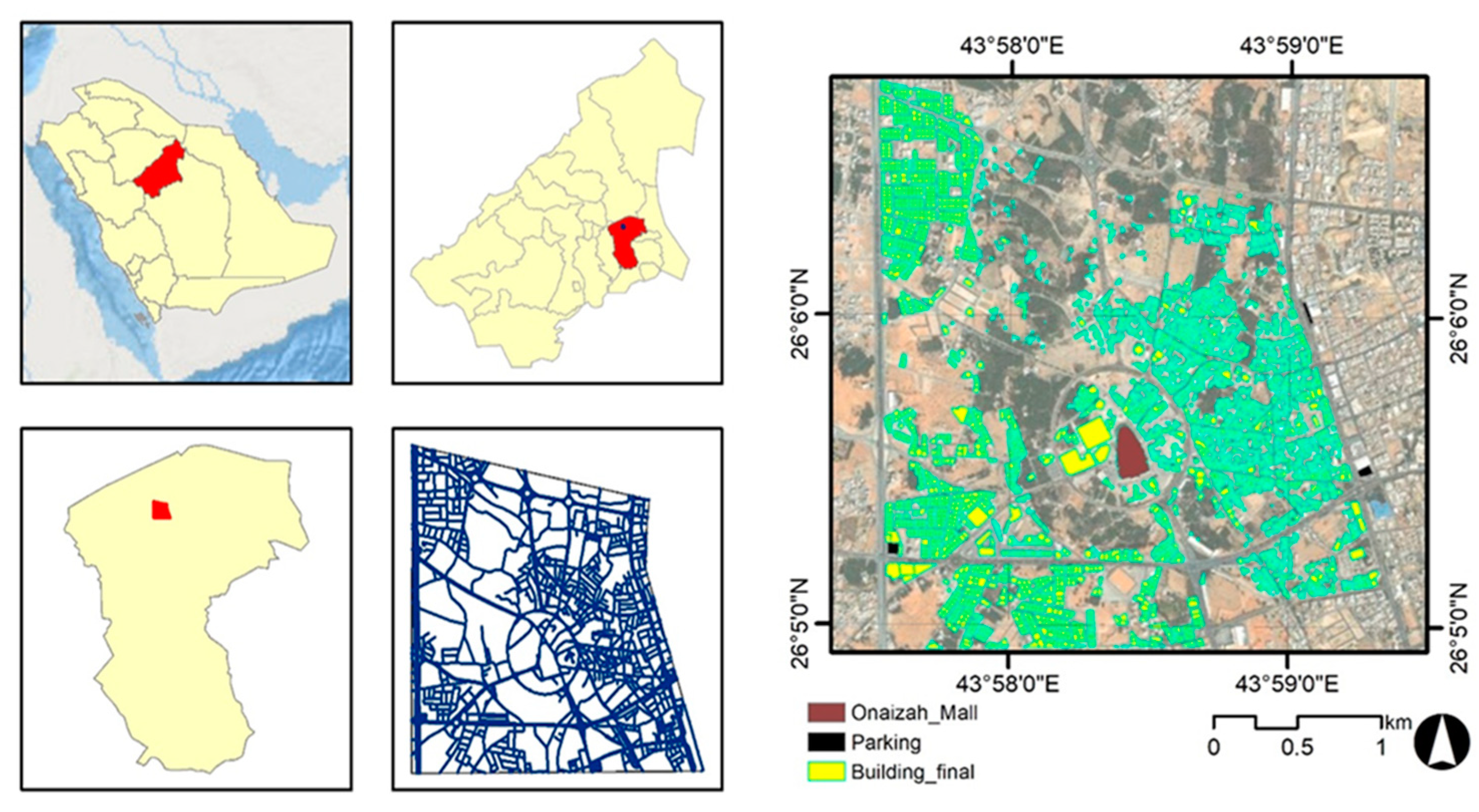
Onaizah City is a city located in Al-Qassim Central Region in Saudi Arabia. It is situated in the central part of the country and is approximately 320 kilometers northwest of the capital city, Riyadh. Onaizah is one of the major urban centers in the Qassim Province and serves as an important economic, cultural, and administrative hub in the region as shown in (
Figure 1).
Onaizah has experienced significant urban growth and development in recent years, resulting in changes to its urban fabric and transportation infrastructure. This makes it an interesting study site for exploring walkability. The city center of Onaizah serves as the central business district and focal point of commercial and social activities in the city. Located within the heart of Onaizah, the city center is characterized by a concentration of shops, restaurants, offices, and public amenities. The city center of Onaizah a diverse range of retail establishments, including local businesses as well as larger national and international chains. It is a bustling area where residents and visitors alike come to shop, dine, and socialize.
In a unique twist, the city center district blends the modern with the historical. Lush palm farms, doubling as parks and restaurants, coexist with heritage palaces and historical sites, creating a vibrant tapestry where residents can enjoy a meal under the palms or explore the rich past around every corner.
3. Materials and Methods
3.1. Data
Walkability in cities is usually affected by many factors such as Accessibility to essential services [
18,
30], the variety of land uses [
28,
31,
32], residential density [
33], Connectivity of the street network [
19,
20], Pedestrian-friendly Street design [
17,
23,
32,
34], safety from traffic and crime [
35,
19].
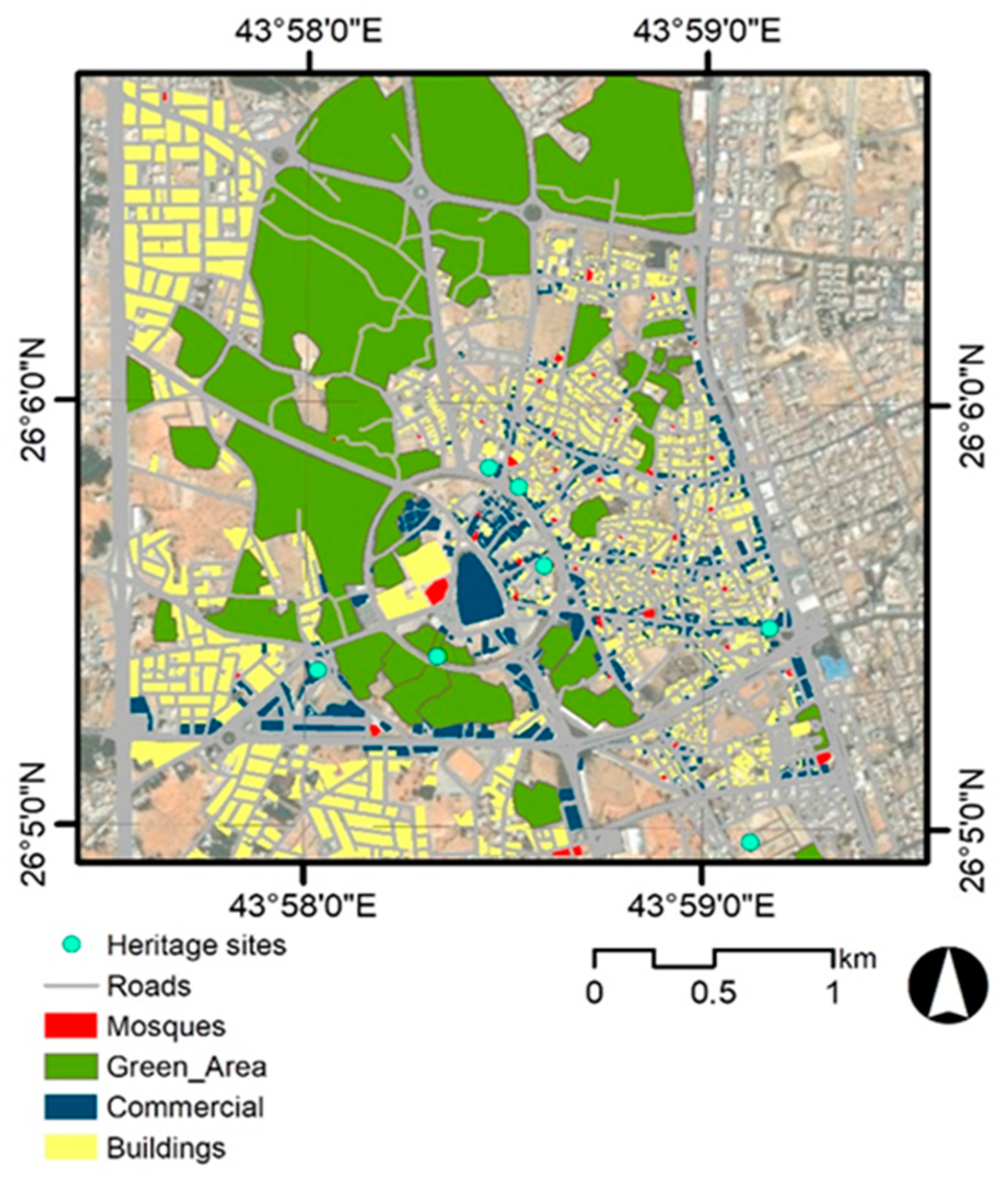
In this study as it explores the possibility of generating thematic walking corridors, four main variables which are heritage sites, green areas, commercial sites, and mosques beside the street network as an incubator for pedestrian walkways as shown in
Figure 2. Other variables such as lighting, terrain, pedestrian safety, and other relevant factors were excluded because all streets are well-lighted, the area is nearly flat and there are no steep slopes, all streets in the study area are two lanes only with a sidewalk in both sides and finally, there is no crime recorded in the area.
The street network was obtained from Open Street Maps, commercial sites, buildings and mosques were obtained from Onaizah Municipality. The green area and palm farms were obtained by digitization of satellite image. The heritage sites were obtained from field visit of the study area
3.2. Least Cost Path (LCP) Analysis
Least cost path (LCP) analysis is a technique used in geographic information system (GIS) to determine the optimal or least cost path between two locations based on a specified cost surface. It is widely applied in various fields, such as transportation planning, urban planning, natural resource management, and environmental modeling. LCP was applied in this study to generate the shortest urban corridors that maintain the 15 minutes walking concept.
The raster cost surface assigns different cost values to different locations in space. It is formed by combining raster landscape of the proximity to the four main investigated variables in a weighted manner. Generally, the values of each landscape are scaled to the same range for weighting [
40]. Assuming a path P is given on the cost surface f, the traditional least-cost path
Min Lsum (
P,
f) is expressed as [
36]:
Here, f(i) denotes the value of grid i on the cost surface f, and l(i,j) denotes the straight distance between grids i and j.
3.3. Create a Walkability Index
The walkability index was generated using a Multi-Criteria approach in GIS environment [
33]. This index then was used to generate a cost surface that represents the relative cost of traversing different areas in the city center. The cost surface can be created by assigning cost values to each cell in a raster grid based on the criteria defined in the previous paragraph [
15,
37]. To create a cost surface for determining a walking urban corridors in the city center, the following methodology was used, which involves creating a distance raster, ranking the distance on a scale from 1 to 10, weighting the variables using the Analytical Hierarchy Process (AHP) method, and generating the cost surface using weighted overlay analysis [
12].
3.3.1. Create a Distance Raster
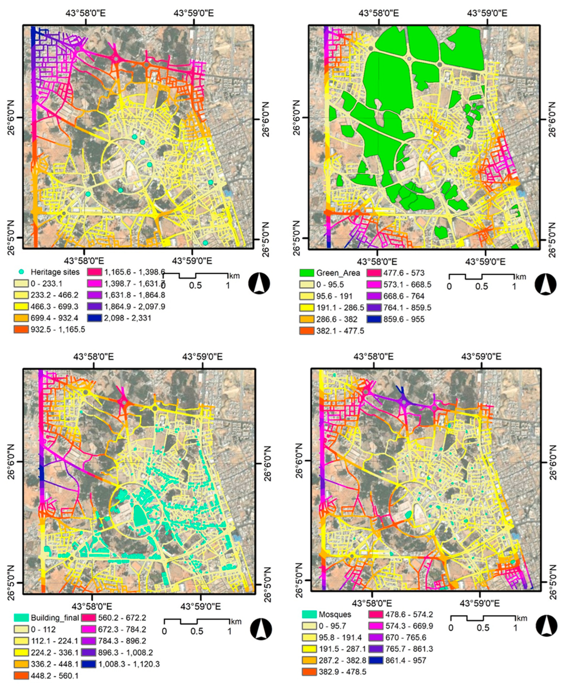
Create a distance raster that represents the proximity of each cell in the study area to the desired variable [
33]. The distance raster grids to the four study variables (heritage sites, green areas, commercial sites, and mosques) are shown in the following
Figure 3.
3.3.2. Rank the Distance
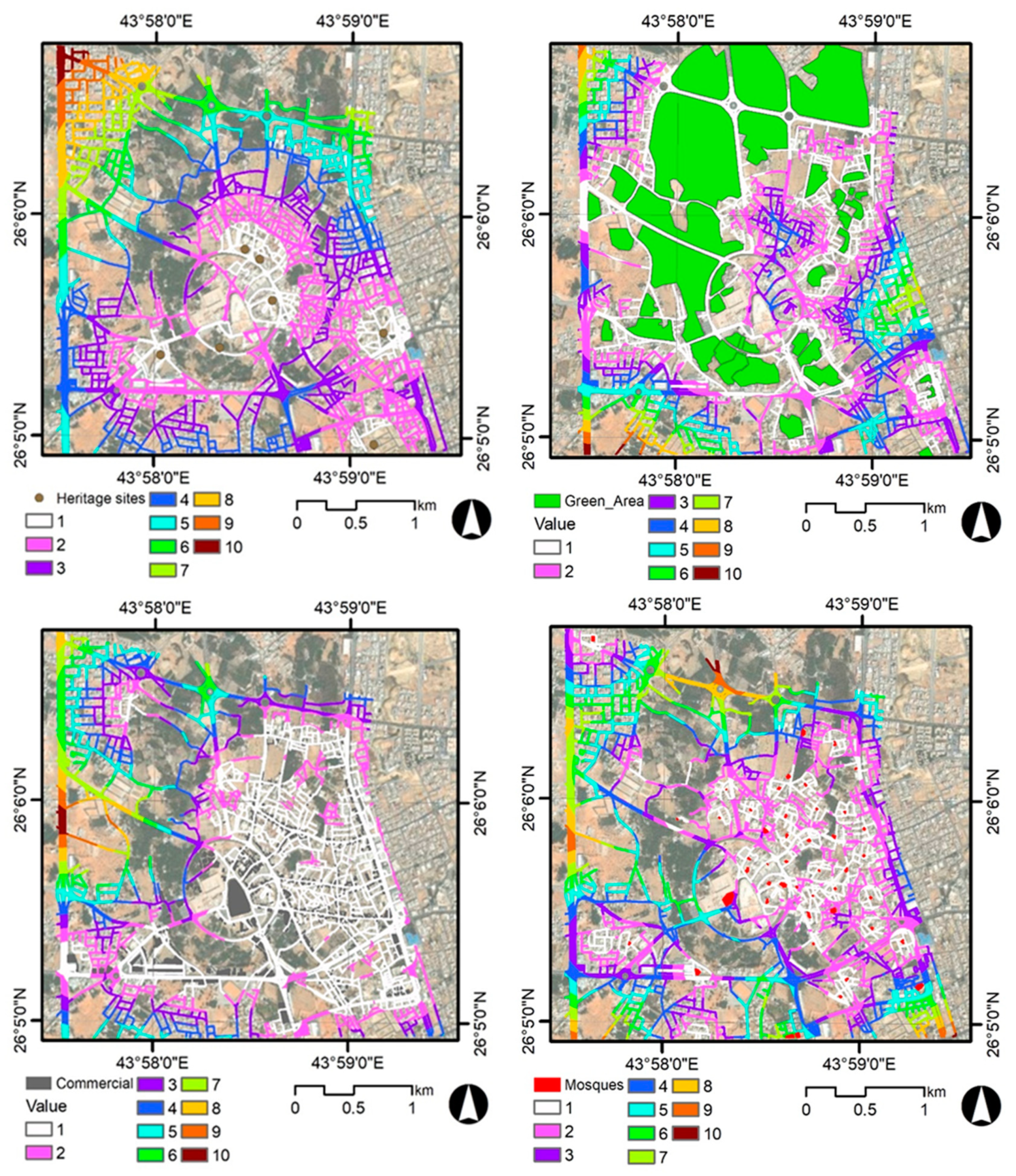
Once the distance raster grids were generated, the distance values were ranked on a scale from 1 to 10, where 10 represents the highest cost value or locations that less attractive for walkability [
28,
33]. The ranked raster grids are shown in
Figure 4. The ranking process plays a crucial role in unlocking the potential of the assigned values. By prioritizing these values, the overlay analysis can effectively combine them. This allows us to identify areas where low values from multiple factors coincide, revealing locations with the most favorable characteristics.
3.3.3. The Analytic Hierarchy Process (AHP)
The Analytic Hierarchy Process (AHP) is a structured technique for making complex decisions. The approach, developed by Saaty [
38], begins with establishing a structure of criteria and elements and organizing them into a hierarchical system. It excels at situations where multiple criteria influence the outcome, and these criteria can be subjective or difficult to quantify. After defining the criteria and through a series of pairwise comparisons, the relative importance of criteria and how well each option fulfills those criteria can be assessed. This systematic approach translates subjective judgments into numerical values, allowing for the calculation of a final score for each option. For comparison, each criterion is evaluated in terms of each category by awarding values between 1 and 9.
Table 1 shows the scale and their respective value descriptions.
3.3.4. Weight the Criteria
Once the criteria were set, we commenced a pair-wise comparison matrix [A] using the scale shown in
Table 1. The factors for each level and their weights are A
1, A
2, . . ., A
n and W
1, W
2, . . ., W
n.
The importance value of a
i and a
j is shown as a
ij. The pair-wise comparison matrix of factors A
1, A2, . . . , An as A = [a
ij] is presented as [
40]:
In the matrix, the element a
ij = 1/a
ji and, thus, when i = j, a
ij = 1. The matrix was normalized using the equation
ij= 1,2,3 …… n.
Finally, the weights of the criteria can be computed using the following formula:
where W
i is the total weight of the criterion.
In this research, analyzes showed that heritage sites have a high importance, with a weight of 40.0%, followed by green areas in importance, with a weight of 30.0%. While we find that mosques and areas with commercial floors have equal weights of 15.0%, with relatively less importance, according to pairwise comparisons using the AHP method used in the study. These weights can guide decision makers and planners in re-planning the city center of the study area and allocating resources aimed at enhancing walkability by prioritizing actions and investments based on the relative importance of each criterion.
3.3.5. Checking the Consistency
Additionally, the AHP promotes consistency in decision making by verifying pairwise comparisons for logical consistency [
39].
Within the AHP framework, the assessment of consistency is carried out through the use of the consistency ratio (CR). The CR is determined by comparing the consistency index (CI) with an average random consistency index (RI). The consistency ratio and the CI are defined by Equations (5) and (6) as follows:
where CI represents the consistency index, λ
max is the primary or principal eigenvalue of the matrix (and is calculated from the matrix), and n is the matrix’s number of factors. The average random consistency index (RI) [
38] is also derived from these factors.
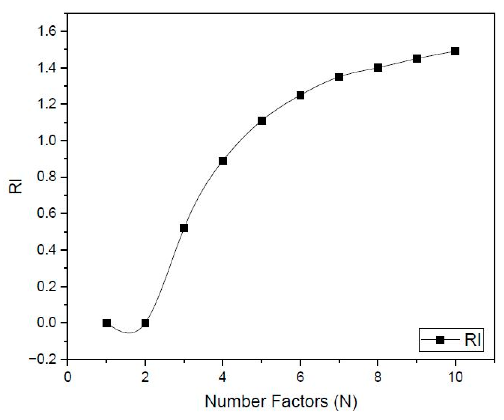
Table 2 and
Figure 5 shows the value of RI based on the number of factors (N)
In the AHP, a CR result below 0.1 is deemed acceptable, while a result exceeding this threshold leads to rejection [
38]. In this study, the CR for all comparisons was below 0.1, signifying its suitability for the AHP analysis.
The Figure shows the relationship between the walkability index and various factors, such as the number of pedestrians, the presence of sidewalks, and the availability of public transportation. The graph is likely used to support the research objectives of the study.
4. Results
The walkability index provides insights into the relative ease associated with walking in different areas of the city center, taking into account the defined criteria [
21].
It serves as a visual representation of the varying levels of walkability based on the assigned weights and ranked distances.
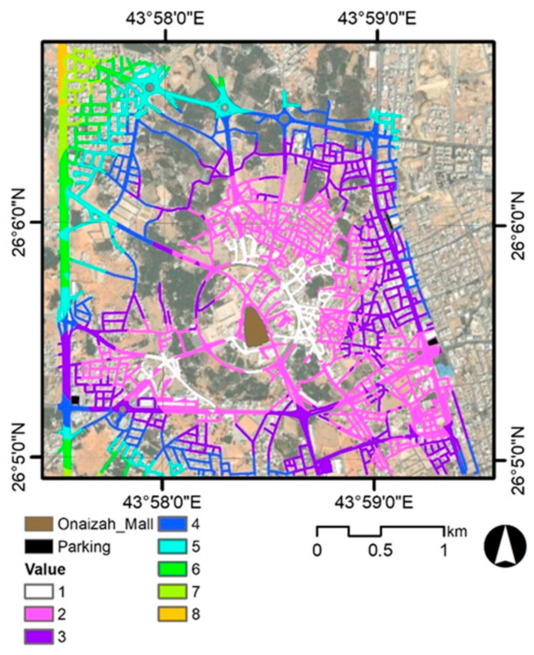
Figure 6 shows the walkability index in the study area on a scale of 1 to 8 and uses a color gradient or shading scheme, where different colors represent varying levels of walkability. Areas represented with high numbers and darker or more intense colors indicate greater challenges or barriers to pedestrian movement. Conversely, areas with a lower number are represented with lighter or less intense colors, suggesting more favorable conditions for walking.
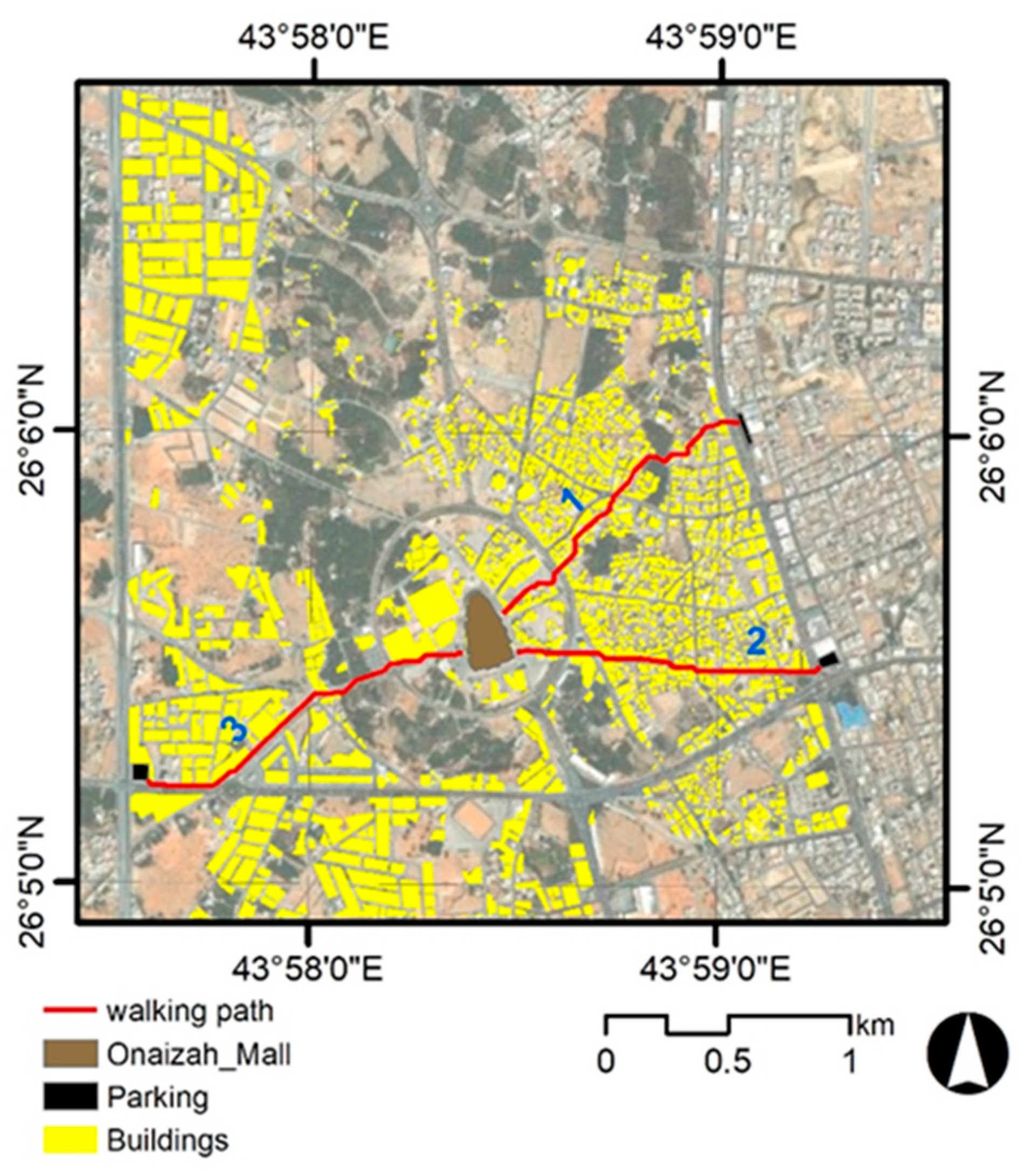
The walkability index was used as the cost surface raster and the least cost paths were generated from three start points to the city center as the destination point. The result is shown in
Figure 7 and
Table 3.
The walking urban corridors start from different start points and all ended at the city center. These offer opportunities for walking to a wide sector of Onaizah pedestrians from many locations in the city. All urban corridors are with reasonable length range between 1283 to 1507 which aligned with the 15 minutes’ standards for walking. This finding aligns with previous research that emphasizes the positive relationship between shorter walking distances and increased pedestrian activity. The walkability analysis, based on the walkability index, also provides insights into the factors influencing the least cost path.
The study successfully employed multi-criteria and cost distance analysis calculation to infer the least cost path, which represents the most efficient and cost-effective route for pedestrians. The integration of GIS techniques proved to be instrumental in analyzing street networks and assessing walkability in Onaizah City. The findings are as follows:
a- Heritage sites: were given the highest weight of 40.0%. This indicates that preserving and enhancing the accessibility to heritage sites is crucial for promoting walkability in Onaizah City. The cultural and historical context of the city plays a significant role in improving the pedestrian experience and creating a vibrant urban environment.
b- Green areas: The availability and suitability of green spaces was set at 30.0%. This highlights the importance of linking parks and other green spaces in urban planning to enhance walkability. Green areas contribute to the overall pedestrian experience by providing green spaces that are more attractive for walking.
c-Through the results of the study, we find that he or she received equal relative weights in relative importance and less than green areas and heritage areas. Despite this, its inclusion in the standards indicates its role in the urban fabric. Mosques serve as important community spaces, and commercial sites contribute to the city's vitality and economic activity.
The results of this study provide a better understanding of walkability in the city of Onaizah and provide insight for evidence-based decision-making in the urban planning process. Through GIS analyzes and assessing the relative importance of different criteria, planners and decision makers can identify priorities that are consistent with enhancing walkability, including improving pedestrian infrastructure, providing green spaces, and emphasizing the preservation and accessibility of heritage sites.
5. Discussion
The current study was concerned with evaluating the criteria and factors influencing the selection of suitable sites and exploring the possibility of walking in the city of Onaizah. The study highlighted the importance of preserving heritage sites, integrating green areas, and taking into account commercial sites and mosques in urban planning.
The Kingdom of Saudi Arabia has shown the utmost importance in achieving the Saudi Green Vision 2050 and achieving environmental sustainability, including enhancing walkability in its cities, with a special focus on this aspect in the development plan of the Kingdom of Saudi Arabia’s Vision 2030, and that vision set prominent goals by diversifying... Sources of income in the field of economics, developing the tourism sector, and enhancing environmental sustainability. In order for this to be achieved, attention must be paid to strengthening pedestrian infrastructure and creating more pedestrian-friendly environments in Saudi cities.
The Kingdom of Saudi Arabia seeks to achieve environmental sustainability through its focus on improving the possibility of walking in Saudi cities and in city centers and reducing the use of cars, which contributes to reducing environmental pollution and providing a healthy climate and urban cities in line with the Kingdom’s Vision 2030.
There are many walking experiments implemented around the world, which we previously discussed in the introduction to the study, which showed their positive results when providing walking paths in city centers. Therefore, the Kingdom’s Vision 2030 focuses on creating a pedestrian-friendly infrastructure that encourages them to walk, such as sidewalks and pedestrian crossings. And urban corridors designated for walking, which enhances the concept of well-being for all residents and visitors by integrating green spaces, gardens, and recreational places
Finally, by investing in walkability, Saudi Arabia aims to provide a high-quality tourist experience, reduce environmental impacts, and contribute to the long-term well-being of its cities and residents.
6. Conclusions
This study provides a graphic representation of the suitability of walkability urban corridors in Onaizah City. The resulting map holds significant value as a tool for urban planners and stakeholders, aiding in the identification and planning of future pedestrian routesIn contrast to other research, this study emphasizes that four important variables—heritage sites, commercial sites, green spaces, and mosques—are necessary to determine if a location is suitable for walking, as determined by a Multi-Criteria method in a GIS context.
The study places a strong emphasis on enhancing walkability in Onaizah City, providing a solid basis for evidence-based decision-making in urban planning. By leveraging GIS techniques and carefully considering the relative importance of different criteria, urban planners and policymakers are empowered to prioritize actions and investments that align with the goal of improving walkability. This perspective has the potential to influence decision-makers to prioritize the development of walkability due to its wide-ranging social and environmental benefits.
7. Future Recommendations
- a)
The future research can conduct comparative studies across multiple Saudi Arabian locales or similar contexts. This can provide insights into the similarities and differences in walkability factors and their relative importance in different regions. Comparative studies can help identify common patterns and robust findings that can guide urban planning efforts on a broader scale.
- b)
Assess the impact of interventions: It would be valuable to conduct longitudinal studies that evaluate the impact of specific interventions aimed at enhancing walkability. By implementing targeted interventions such as infrastructure improvements, pedestrian-friendly policies, or community engagement initiatives, researchers can measure the effectiveness of these interventions in improving walkability. This can provide evidence-based recommendations for future urban planning and policy initiatives.
- c)
Integrate emerging technologies: With the rapid advancement of technology, future research can explore the integration of emerging technologies such as augmented reality, mobile applications, and smart city solutions in assessing and enhancing walkability. These technologies can provide real-time data, interactive mapping tools, and personalized recommendations to improve the pedestrian experience and promote sustainable mobility.
8. Limitations
Generalizability to other locales: The findings and recommendations of this study are specific to Onaizah City and may not be directly applicable to other locales. The cultural, geographical, and infrastructural context of Onaizah City may significantly influence the factors that contribute to walkability. Therefore, caution should be exercised when generalizing the findings to other regions. Future research should aim to replicate the study in different locales especially in Saudi Arabia (The study case) to validate and adapt the findings to specific contexts.
Author Contributions
Each author has made substantial contributions to the conception and design of the work. The corresponding author (Mohammed Aloshan), Moustafa Gharieb, Khaled Mahmoud Heba: ideas development. Mohamed salah Ezz and Ragab Khalil: design of methodology. Mohamed salah Ezz, Ragab Khalil and Moustafa Gharieb: writ-ing-original draft preparation and performed the data analysis and interpretations. Mohammed Aloshan has modified the detailed descriptive and deductive approaches, Moustafa Gharieb, Mohamed salah Ezz, Ragab Khalil (contributed to the data re-sources). Mohammed Aloshan revised the manuscript data curation, writing, and ed-iting. Mohammed Aloshan funding acquisition and project administration, and Mo-hammed Humaid Alhumaid reviewing and software. The authors read and approved the final manuscript. All authors have read and agreed to the published version of the manuscript.
Funding
This work was supported and funded by the Deanship of Scientific Research at Imam Mohammad ibn Saud Islamic University (IMSIU) (grant number IMSIU-RG23116).
Data Availability Statement
The raw data supporting the conclusions of this article will be made available by the authors on request.
Conflicts of Interest
The authors declare no conflicts of interest.
References
- Al-Balawi, A. Z., & Al-Qadi, M. I. (2020). Vision 2030 and the transformation of Saudi Arabian cities: From car-centric to sustainable development. Land Use Policy, 99, 105102.
- Al-Mulhim, H. (2019). Sustainable urban development in Saudi Arabia: Vision 2030 and beyond. Sustainability, 11(13), 3636.
- Al-Ansi, S., & Habib, R. (2022). Walkability and public health in emerging cities: A case study of Dammam, Saudi Arabia. Journal of Urban Health: Bulletin of the New York Academy of Medicine, 99(3), 544-553.
- Al-Hazim, Y., & Aldwoah, M. (2021). The relationship between walkability and physical activity among adults in Riyadh, Saudi Arabia. International Journal of Environmental Health Research, 31(1), 102112.
- Al-Kodmany, O., & Al-Qadi, M. I. (2018). Developing a walkability assessment framework for sustainable urban communities in Saudi Arabia. Habitat International, 84, 185-196.
- Rezaei, M., Rakha, H., & Ghadiri, S. (2017). A comprehensive review of factors affecting walkability: A case for the Middle East and North Africa region. Travel Behaviour and Society, 11, 114-129.
- American Planning Association (APA). (2016). Walkable communities, healthy places. https://www.planning.org/publications/document/9141726/.
- A. Telega and I. Telega, “Measuring Walkability with GIS — Methods Overview and New Approach Proposal,” 2021. [CrossRef]
- Handy, S. L., Cao, X., & Mokhtarian, P. L. (2010). Land use as a determinant of long-distance commuting: A synthesis of US studies. Urban Studies, 47(6), 1675-1704.
- Ewing, R., & Cervero, R. (2010). Travel and the built environment: Paradise lost. Journal of Planning Literature, 24(4), 367-384.
- F. Fonseca, “Walkable Cities : Using the Smart Pedestrian Net Method for Evaluating a Pedestrian Network in Guimar ã es, Portugal,” 2022.
- M. AlMuharraqi, G. Sweis, R. Sweis, and F. Sammour, “Factors affecting the adoption of smart building projects in the Kingdom of Bahrain,” J. Build. Eng., vol. 62, no. September, p. 105325, 2022. [CrossRef]
- Roe, J., & Aspinall, P. (2011). The benefits of walking in nature: A review of evidence from the UK. Journal of Environmental Psychology, 31(4), 401-413.
- Handy, S. L., Mendoza, C. E., & Perkins, S. E. (2005). Relationship between the physical environment and physical activity among youth in Bogotá, Colombia. American Journal of Preventive Medicine, 29(2), 147-154.
- A. A. Bindajam and J. Mallick, “Impact of the Spatial Configuration of Streets Networks on Urban Growth : A Case Study of Abha City, Saudi Arabia sustainability Impact of the Spatial Configuration of Streets Networks on Urban Growth : A Case Study of Abha City, Saudi Arabia,” no. March, 2020. [CrossRef]
- A. Bartzokas-tsiompras, E. Bakogiannis, and A. Nikitas, “Global microscale walkability ratings and rankings : A novel composite indicator for 59 European city centres,” J. Transp. Geogr., vol. 111, no. June, p. 103645, 2023. [CrossRef]
- T. Santos, F. Ramalhete, R. Pedro, and N. Pires, “Geography and Sustainability Sustainable living neighbourhoods : Measuring public space quality and walking environment in Lisbon,” Geogr. Sustain., vol. 3, no. 4, pp. 289–298, 2022. [CrossRef]
- A. Erath, A. Michael, B. Van Eggermond, S. A. Ordóñez, and K. W. Axhausen, “Introducing the Pedestrian Accessibility Tool Walkability Analysis for a Geographic Information System”.
- M. Jabbari, F. Fonseca, and R. Ramos, “Accessibility and Connectivity Criteria for Assessing Walkability : An Application in Qazvin, Iran,” 2021.
- A. Ozbil, J. Peponis, and B. Stone, “Understanding the link between street connectivity, land use and pedestrian flows,” vol. 16, pp. 125–141, 2011. [CrossRef]
- F. Fonseca, “Walkable Cities : Using the Smart Pedestrian Net Method for Evaluating a Pedestrian Network in Guimar ã es, Portugal,” 2022.
- G. Hassanshahi, A. Soltani, and M. Roosta, “ScienceDirect Walking as soft mobility : A multi-criteria GIS- based approach for prioritizing tourist routes,” vol. 12, pp. 1080–1096, 2023.
- P. Sahin, “Analysis of Walkable Street Networks by Using the Space Syntax and GIS Techniques : A Case Study of Çankırı City,” 2023.
- O. Klein, F. Escobar, T. Al, and P. Gull, “Computers, Environment and Urban Systems Development of a GIS-based walking route planner with integrated comfort walkability parameters,” vol. 103, no. February, 2023. [CrossRef]
- M. O. F. Architecture, “STUDY OF PEDESTRIAN MOVEMENT IN RELATION TO SPATIAL CONFIGURATION AND LAND-USE PATTERN IN THE CONTEXT,” no. December, 2016.
- T. Case, C. Old, and F. Fareh, “The Effect of Spatial Configuration on the Movement Distribution Behavior,” vol. 12, no. 5, pp. 9136–9141, 2022.
- S. A. Waheeb, B. Zerouali, A. Elbeltagi, M. Alwetaishi, and Y. J. Wong, “Enhancing Sustainable Urban Planning through GIS and Multiple-Criteria Decision Analysis : A Case Study of Green Space Infrastructure in Taif Province, Saudi Arabia,” 2023.
- Schröpfer, T.; Menz, S.; Yeo, M.T. From garden city to city in a garden and beyond. In Dense and Green Building Typologies: Research, Policy and Practice Perspectives; Springer: Berlin/Heidelberg, Germany, 2019; pp. 21–25. [Google Scholar]
- S. A. N. I. S. Uleiman, V. C. A. Garwal, D. E. L. Al, and A. M. S. Unusi, “Optimal Route Location by Least Cost Path ( LCP ) Analysis using ( GIS ), A Case Study,” vol. 04, no. 44, pp. 9621–9626, 2015.
- H. Abusaada, “Can Public Spaces Alleviate Poverty-Related Feelings ? Content,” 2023.
- “Assessment of Urban Spaces of Mixed-Use Areas and Their Role in Achieving Social Sustainability in Closed Urban Communities in Greater Cairo,” vol. 7, no. 5, p. 705014, 2023.
- T. Hartig, R. Mitchell, S. De Vries, and H. Frumkin, “Nature and Health,” 2014. [CrossRef]
- A. Ozbil, T. Gurleyen, D. Yesiltepe, and E. Zunbuloglu, “Comparative Associations of Street Network Design, Streetscape Attributes and Land-Use Characteristics on Pedestrian Flows in Peripheral Neighbourhoods,” 2019.
- A. Erturan and S., C. Van Der Spek, “Walkability analyses of Delft city centre by Go- Along walks and testing of different design scenarios for a more walkable environment Walkability analyses of Delft city centre by Go-Along walks,” J. Urban Des., vol. 27, no. 3, pp. 287–309, 2022. [CrossRef]
- A. Council, ASSESSING SAUDI VISION 2030 : A 2020 REVIEW. 2020.
- Tang, Q.; Dou,W. An Effective Method for Computing the Least-Cost Path Using a Multi-Resolution Raster Cost Surface Model. ISPRS Int. J. Geo-Inf. 2023, 12, 287. [CrossRef]
- J. Lee, “Exploring Neighborhood Unit ’ s Planning Elements and Configuration Methods in Seoul and Singapore from a Walkability Perspective,” 2018. [CrossRef]
- Saaty, T.L. A scaling method for priorities in hierarchical structures. J. Math. Psychol. 1977, 15, 234–281. [Google Scholar] [CrossRef]
- AlShareef ,F and Aljoufie, M. Identification of the Proper Criteria Set for Neighborhood Walkability Using the Fuzzy Analytic Hierarchy Process Model: A Case Study in Jeddah, Saudi Arabia. Sustainability 2020, 12, 9286.
- Sepehrian, Z, Khoshfetrat, S and Ebadi, S. An Approach for Generating Weights Using the Pairwise Comparison Matrix. Journal of Mathematics. 2021. | Article ID 3217120 |. [CrossRef]
|
Disclaimer/Publisher’s Note: The statements, opinions and data contained in all publications are solely those of the individual author(s) and contributor(s) and not of MDPI and/or the editor(s). MDPI and/or the editor(s) disclaim responsibility for any injury to people or property resulting from any ideas, methods, instructions or products referred to in the content. |
© 2024 by the authors. Licensee MDPI, Basel, Switzerland. This article is an open access article distributed under the terms and conditions of the Creative Commons Attribution (CC BY) license (http://creativecommons.org/licenses/by/4.0/).
