
Submitted:
21 June 2024
Posted:
24 June 2024
You are already at the latest version
Abstract
Abstract: Since the establishment of multiparty democracy in the 1990s, Malawi has experienced significant political shifts, with elections playing a crucial role in shaping the political landscape. However, there is a lack of comprehensive understanding of the spatio-temporal dynamics of election results, especially regarding voting patterns and their effects on electoral outcomes. This gap hinders political parties, politicians, and electoral stakeholders in effectively managing regional and temporal changes in voting behaviors. Geographic Information Systems (GIS) are underutilized in Malawi for studying geo-graphical and temporal election data. This study utilized GIS to analyze the spatial pat-terns of election results in Malawi since the advent of multiparty democracy. By collecting geographic data on election outcomes, including vote counts, candidate performance, voter turnout, and other relevant data, the study examined how the geographic distribution of votes impacts electoral results. GIS techniques such as spatial analysis, mapping, and spatial statistics were employed to assess the data and create maps illustrating spatial patterns in Malawi's election outcomes. The study revealed that voting patterns in Malawi are significantly influenced by regional lines. These insights can inform political campaigns, voter mobilization efforts, and strategies for electoral reform.
Keywords:
Geospatial
; Legumes
; adoption
; cultivation
; welfare
1. Introduction
Legume production has gained significant attention in recent years due to its potential to promote economic, social, and ecological development among smallholder farmers in Sub-Saharan Africa (SSA) [1,2]. Legumes such as common beans, soya beans, and groundnuts have proven to be of higher economic, nutritional, and ecological value compared to traditional cash crops like maize [3]. With the global legume production doubling over the past decade, SSA accounts for 6% of the global legume production, with Nigeria, Zimbabwe, and South Africa being the top producers [4,5]. Malawi, despite its potential, accounts for less than 1% of global legume production, with low productivity being a significant factor [6].
The Government of Malawi has identified legumes as strategic crops to diversify the cropping system, which is dominated by tobacco and maize [7]. However, despite the potential benefits of legume production, it remains a neglected crop in Malawi, with limited attention from government programs and NGOs [8]. This study aims to assess the socioeconomic welfare impacts of legume adoption among smallholder farmers in Malawi using panel data analysis of Integrated Household Surveys (IHS) four and five.
2. Literature Review
Legume adoption has been advocated as a sustainable intensification strategy for agricultural systems, but its adoption rate remains low [7]. This is despite the tireless efforts put in place by the advocates to stimulate its adoption (White and Crawford, 2016). Over the previous decade, the world has experienced a double increase in demand for legume, calling for an increase in the number of farmers allocating their land to legume production [8]. However, studies, including Kebede (2020), state that, irrespective of the global collaborative efforts by international organizations to stimulate production, adoption has stagnated and is below the expected level.
Waldman et al. (2015) note that, despite their potential role in improving nutrition, soil health, and food security, the farmers’ understanding of the crop’s cultural role in the household and market availability affected the adoption amongst the small-scale farmers in Malawi [9]. The finding suggests that, despite the agronomic factors, there is a need to further understand the soci-economic factors affecting the adoption [10]. This is in line with Kabebe’s (2020) findings, which recommend that, for Malawi to realize noticeable fruits in the adoption rate, there is a need for a wide array of technical, economic, social, and institutional factors to be considered [11].
Scholars have argued that, despite the accumulation of evidences in the volume of literature supporting legume production to accelerate an increase in small-scale farmers’ income, food security, and risk preparedness, the welfare economists have always argued that the agricultural policies favoring legume production are not the end in themselves, as they need to be coupled with technical, economical, and institutional factors [12]. For example, Tirivanhu and Ekepu (2016) study, which employed logistics regression, noted that strengthening legume value chains, improving access to extension services and well-structured markets, and adoption of population controlling policies can significantly increase legume adoption [13].
Kabede (2020)’s findings further found that weak policy attention, poor networking in accessing inputs and market, and poor market information and intelligence are the key constraints hindering the progress of legume adoption [14]. This indicates that there is a need for more to be done in improving the institutional, households’ socio-economic factors to increase the adoption rate of legumes in Malawi.
Welfare Impacts of Legume Adoption
The quest for increasing income and food security among rural populations, which heavily rely on small-scale farming, has gained wider popularity and remains the center for policy discussions [15]. For ages, the pro-poor approaches identified and implemented by nations towards “ending all forms of poverty elsewhere”; a number one agenda of the sustainable development goals (SDG), have their pathways towards improving the welfare of the small-scale farmers [16]. In a similar manner, here in Malawi, the approaches taken in a vision to develop into “an inclusively wealthy and self-reliant nation” has taken various dimensions with a key focus on improving the welfare of the rural population, where a multitude lean on small-scale cultivation [17].
The huge body of literature documents that, despite the enactment of various social welfare policies, which include Malawi Growth and Development Strategy II (MGDSII), National Social Support Policy (NSSP), and National Gender Policy (NGP), Malawi is lagging behind, as it still registers higher as 73.5% poverty levels (World Bank, 2022) [18]. Additionally, the reports show that the income inequalities of the ultra-poor population have worsened from 25% in 2012 to 27% in 2020 (Malawi Demographic and Health Survey-MDHS-2020) [19].
3. Materials and Methods
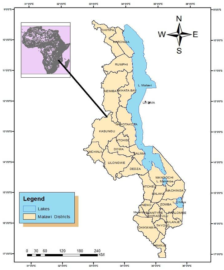
This study utilized two waves of nationally representative panel data from the Integrated Household Surveys (IHS) 4 and 5, collected by the Government of Malawi (GoM) through the National Statistical Office (NSO). IHS 4 was conducted from March 2015 to March 2016, covering the 2016/2017 agricultural marketing seasons, while IHS-5 was conducted between April 2018 to April 2019, covering the 2019/2020 agricultural marketing season. The datasets consisted of 1688 households in IHS 4 and 1534 households in IHS 5. After balancing the panel, 703 households were retained for each panel, and 1046 households were retained for the combined panels, resulting in an attrition rate of 45%. The data included farming households’ demographics, institutional, and ecological characteristics.
Empirical Models
The objective of this study was to analyse the impact of legume adoption on household welfare. We therefore start by specifying and estimate the model for determinants of legume adoption. To account for the intensity of adoption, the area under the legume production will be used as the dependent variable of determinants of the legume production.
Among the smallholder farmers, the production decisions for a chosen crop are thought to be a dependent variable determined by quite a number of factors (Gobena, 2012). Production decisions are generally done to maximize the expected returns which in turn is the function of the land allocation and the technology function which again is the function of the input and output prices (Verkaart et.al.,2017). The literature documents quite a number of factors that affects the adoption of the legume production among smallholder famers. Among the often-cited factors are the household landholding size, risk, human capital, labour availability, credit access, land tenure and access to input, output markets and the extension services (Feder, 1985; Tanti et.al., 2022). Additionally, the adoption decisions are also influenced by the agro-ecological and agronomic circumstances surrounding the small-scale farmers which may include: soil quality and type, rainfall patterns as well as the farming systems (Cavatassie et.al. 2010). Household’s endowments of natural, human, financial, physical and social capital constitute the resource constraints based on which wellbeing is maximized. Therefore, in addition to factors of production, our model of adoption includes household demographic characteristics such as household size and characteristics of the household head. We then estimated the determinants of legume adoption using random effects model and we specified the adoption model as follows:
where is the constant
Where Kit is the area planted legumes by household i in year t
Xit is the vector of household demographic characteristics
Tit is a vector of institutional and ecological factors and
Zi is the vector of time-invariant agronomic and individual characteristics both of which influence the preference of legume adoption to other crops.
εit is a compound error term consisting of unobserved time-invariant.
The study’s interest is to understand the welfare impacts of adopting the legume production. Therefore, to do this, we estimated the welfare impacts using the fixed effects model thereby extending our analysis by specifying equation (2) in our econometric model:
Ii is the depended variable from the selected welfare indicators namely pericapta income, consumption and household asset holding. Kit is the area under legume production. All other variables are as described above.
To analyses the periodic impact of legume adoption over the years, we used the random effects model under the specification of the following model:
Whereby A, , ,t are as described above and is the dummy for the year 2016. “0” is for the year 2019 and “1” for 2016.
4. Results
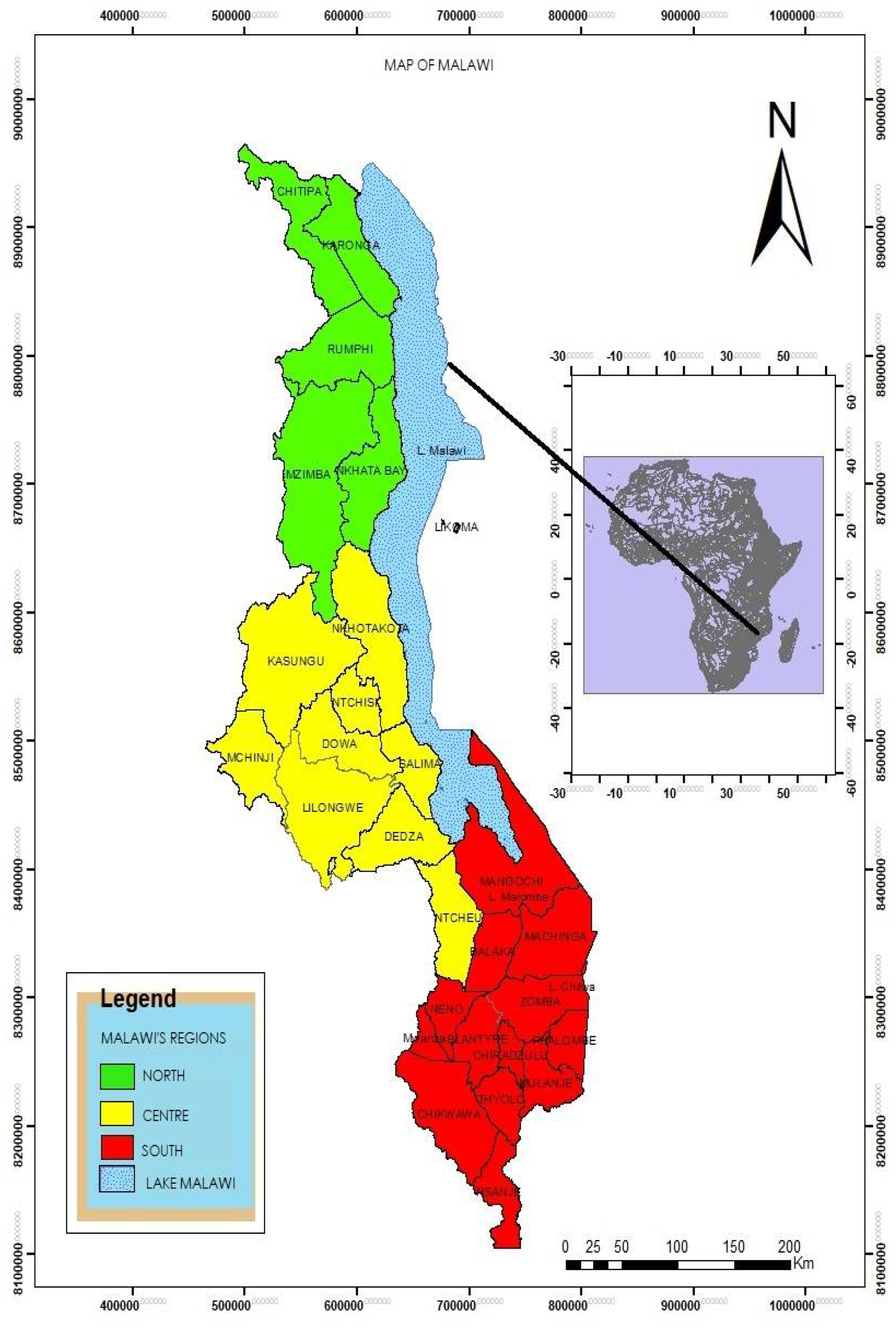
The study used balanced panel data with sample size of 1406 households from all three regions of Malawi. Respectively covers 1688 and 1534 in 2015/2016 and 2018/2019 with 260, 1,153, 275, 334, 1152 and 48 households for the three regions of the two waves respectively (Table 1).
The study used balanced panel data with sample size of 1406 households from all three regions of Malawi. Respectively covers 1688 and 1534 in 2015/2016 and 2018/2019 with 260, 1,153, 275, 334,1152 and 48 households for the three regions of the two waves respectively (Table 1).
Figure 2.
4.1. Area under Legume Production
The average smallholder farmer landholding size was 1.91 acres in 2016 which reduced to 1.83 in 2019(Table 2). Out of the total landholding, allocation to non-leguminous crops was 50% much higher than the land allocation to the legumes (Figure 2). This is because, besides the rapid increase in population over time which is reducing Perica pita landholding, small holder farmers in Malawi are characterised by the small landholding size out of which large share is used for subsistence farming (NSO,2018). However, Figure 1, indicates that over the years there has been an increase in the area allocation to the legume production. This is accompanied by the decrease in the area allocation to the non-leguminous crops. This is because in the context of Malawi, cereals and legumes are complementary crops suggesting an inverse relationship between the land allocation to the legumes and the other crops. Statistically, there is significant difference in the landholding size between the legume adopters and the non-adopters in 2016 legume adopters had an average landholding of 2.23 acres compared to the 1.77 acres by the non-adopters. Despite the decrease in the smallholder farmers landholding size in the years of study, in 2019 the legume adopters had 0.51 acres land higher than the non-adopters (Table 2).
4.2. Legume Adoption
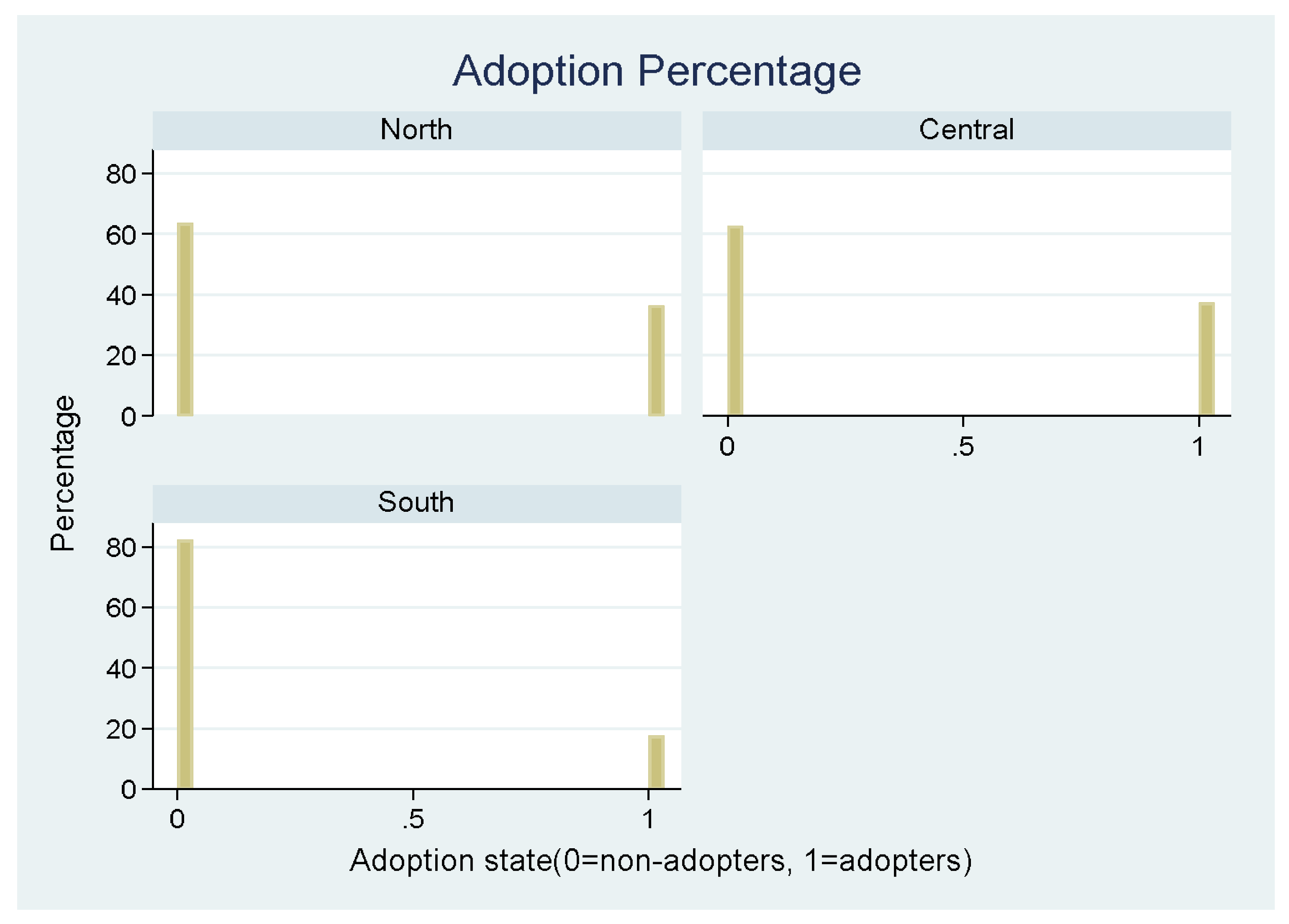
The study firstly, focusses on identifying the determinants of legume adoption using double hurdle model which takes into account the intensity of adoption through considering land allocated to legume production. We therefore, considered land under legume an appropriate proxy for adoption. Although on average the landholding size among legume adopters is 0.49 acres higher than the landholding size among non-adopters (Table 3), there has been decrease in the land allocation to legume signifying lowering in the adoption rate. This again is explained by an ever increase in demand for the staple food to meet the food requirements for the growing population hence smallholder farmers have been shifting land from legumes to the other crops particularly maize (Brand,2011). The central and northern regions have both 39% rate of adoption while Southern region ranked behind with 19% (Figure 4). The results shows that over the years, Central region experienced an increase in the adoption rate. The results are different from the North as well as the Southern region which shows that during the period under analysis, the adoption rate decreased.
Figure 4.
Trend of Legume adoption by rgion.
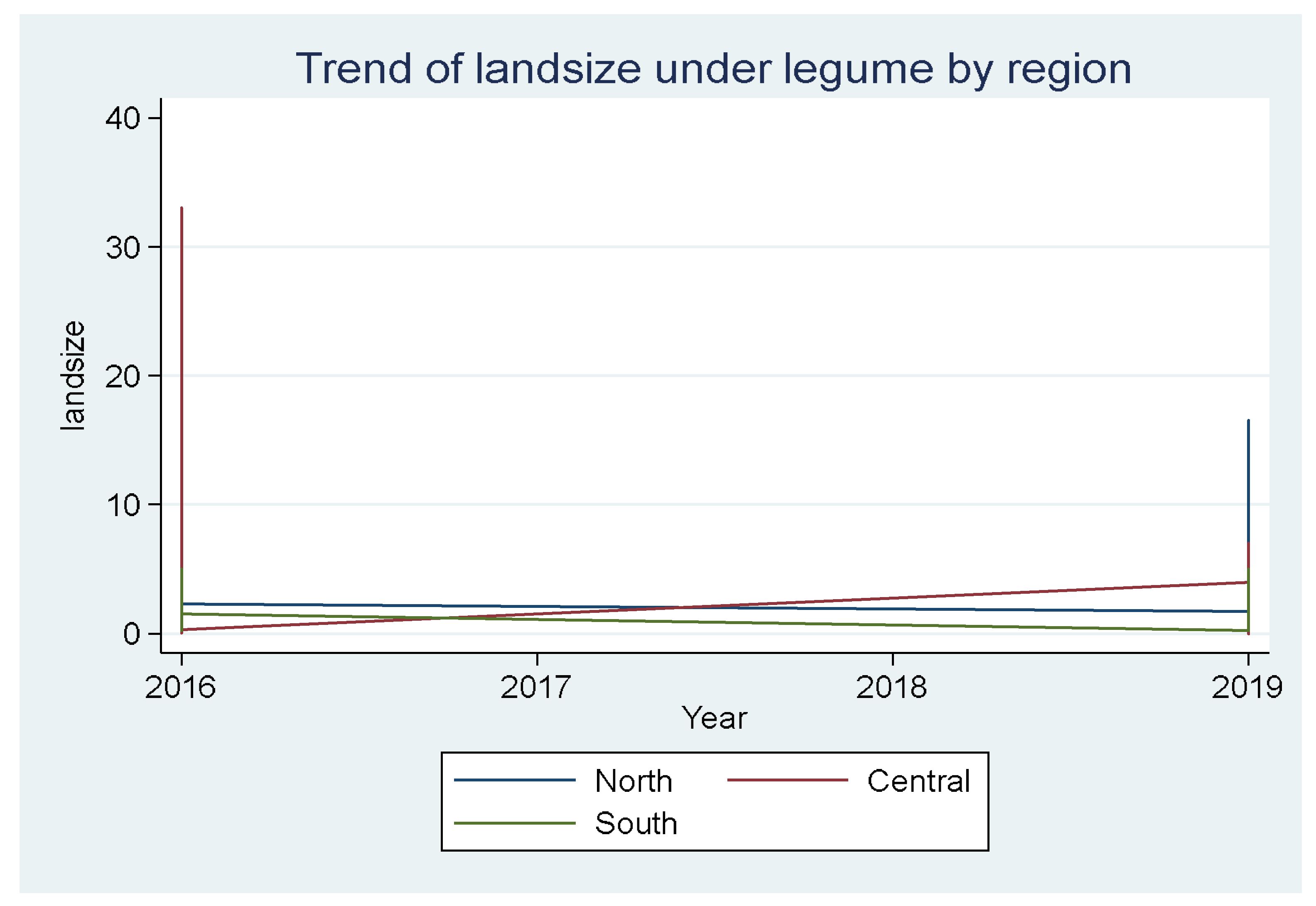
Figure 5.
Percentage of adoption by region.
4.3. Socio Demographic and Socioeconomic Characteristics
Table 3 indicates that there are systematic differences between adopting and non-adopting households. For example, in 2019, adopters’ transformed household size is found to be significantly higher than the non-adopting households. The results on the distance to the nearest agricultural market indicate that there is significant difference between the adopters and the adopters. The annual rainfall for the location of the adopters is found to be significantly higher than the rainfall amount in the locations of the non-adopters.
Similarly, the distance to the ADMARC was found to be statistically different between the adopters and the non-adopters. The results also show that there are significant variations in the welfare of the adopters and the non-adopters as the adopters are experiencing higher consumption, expenditure, asset holding and possess large landholding sizes.
The study was interested in analysing the welfare impacts of legume adoption through the welfare indicators such as asset holding, consumption and income and the household expenditure. Table 2 indicates that although inconsistently observed, the welfare indicators under study which includes the household expenditure, consumption, asset holding significantly vary between the two groups. For instance, in 2016, the adopters were spending MWK8.89, higher than the non-adopters. Additionally, in 2019 the calorie intake per capita for the adopters was 1.63 calorie higher than the calorie intake for the non-adopters. In 2016, the adopters were having larger number of assets compared to non-adopters. The results are hereby indicating that although inconsistently which may be due to other Political, Economic, Social, Technological factors, the adopting households were significantly experiencing the better welfare than the non-adopters.
Figure 5 indicates that during 2016 to 2017, the household of the adopters were experiencing increase in household expenditure which the literature suggests it is correlated with the household income Frank et.al (2014). However, since 2017 to 2019, the expenditure has been decreasing which may be attributed to other PESTEL factors which includes the legume price fluctuations, risks and the shocks. For example, Figure 5 indicates a sharp decline in the household expenditure in 2019 which literature suggests is due to the poor market existence which highly affected the prices and the incomes of the legume adopters Dzanja et.al (2019) highly reduced the incomes of the small-scale legume adopters due to price fluctuations in low-income countries such as Malawi. Figure 6 presents complementing argument as it is suggesting that over the years under analysis, the adopters’ households experienced a dramatic increase in the per capita consumption. This is because besides carbohydrates, legumes are the important source of calories in the developing countries hence inexistence of satisfactory market coupled with the dual economic nature of the small scale farmers, increased the household per capita calorie intake.
4.4. Econometric Results
4.4.1. Estimation of Legume Adoption
To identify the determinants of legume production we run random effects model specified in (eq.1). The disaggregated results for the adopters are as displayed in Table 6.

Table 4.
legume adoption decision using double hurdle random effect.
| Variables | Coefficient | Standard Error | P-Values |
|---|---|---|---|
| Constant | 2.777*** | 0.630 | 0.000 |
| Soil Type | 0.099* | 0.045 | 0.027 |
| Gender (Male=1) | -0.080 | 0.087 | 0.357 |
| household size | -0.031 | 0.066 | 0.638 |
| Annual - temperature(oC) |
-0.007*** |
0.018 |
0.000 |
| Rainfall(mm) |
0.001** |
0.0004 |
0.004 |
| off-farm activity income |
0.0003 |
0.0003 |
0.289 |
| access to extension |
0.149* |
0.083 |
0.073 |
| implement ownership |
-0.080 |
0.156 |
0.605 |
| landholding size(acres) |
0.112** |
0.044 |
0.012 |
| land ownership (0=yes) |
-0.076*** |
0.007 | 0.000 |
| School attendance(1=yes) |
-0.054 |
0.091 |
0.553 |
| Age(head) | 0.0004 |
0.003 | 0.898 |
| Off farm activity dummy | -0.244* | 0.132 | 0.065 |
| Number of observations | 496 | ||
| R-squared | 0.463*** | 0.776 | 0.000 |
| ***, **, *, mean significance at 1%, 5%, and 10% level, respectively | |||
Overall, the model is statistically significant at 1% with 48% variations in the area under legume production explained by the explanatory variables. The test for the heteroscedasticity revealed the presence of the homoscedasticity. We transformed the variables using the natural log as a remedy to the violation of the assumption of the heteroskedasticity.
4.4.2. Ecological Factors Affecting Legume Adoption
4.4.2.1. Soil Type
The soil type is one of the ecological factors affecting the legume production. The results indicate that the soil type significantly affects the size of land allocated to a legume production. Disaggregating the results by the soil type indicated that there was 0.5 acres decrease in the legume adoption rate among the farmers whose their land soil is katondo, clay and sandy. The results are significant at 10%. This is in line with the Diatta et.al. (2019) findings which found that the legumes such as soyabeans and the groundnuts do better in the soils with the intermediate soil types such as loam clay or sandy loamy as compared to other soil types.
4.4.2.2. Mean Annual Temperature
Besides the soil type, the literature suggests that temperature is among the key ecological factors affecting the legume adoption in the SSA (Maggio et.al.,2021). The results indicates that significant at 1%, a degree’s Celsius increase in the temperature above the seal level significantly decreases adoption of the legume by 0.01 acre of land. This is because an increase in temperature reduces leaf area of legume plants which consequently affects the overall production hence farmers in the high temperature areas prefer growing other crops than legume.
4.4.2.3. Mean Annual Rainfall
One of the characteristics of the small-scale farming enterprise in Malawi is that the production decision is subject to the unimodal rainfall due to lower rate of irrigation technology adoption. It thus comes that the farmers decision to grow a particular crop is influenced by the rainfall amount their location receives. The results in Table 6. Indicate that a 1mm increase in the rainfall amount in the location of the households, increases the land allocation to the legume by 0.001 acre. The results are significant at 5% with a p-value of 0.003.
4.4.3. Institutional Factors affecting Legume Adoption
4.4.3.1. Access to Extension Services
The institutions factors such as access to extension service describe the context within which the farming takes place. Literature suggests that the access to extension services is one of the determinants of the legume adoption as it facilitates dissemination of information to farmers about the existence of the improved varieties that yield higher output. The results indicate that the access to extension services on the improved legume varieties increases the land area allocation to legume production by 0.15 acres as compared to those farmers who do not have an access to the extension services (Table 6).
4.4.4. Household’s Socioeconomic Factors Affecting Legume Adoption
4.4.4.1. Household Landholding Size
Land is the primary factor of production and stands out as major constraint to the level of farming practiced by the small-scale farmers in Malawi. literature suggest that the average landholding for the small-scale farmers in Malawi is 1.25 acres (0.5 ha) (NSO,2018) hence is one of the barriers to the legume adoption. The results in Table 6 reveals that significant at 5%, the increase in per capita household landholding size is accompanied by 0.12 acres increase in land allocation to the legume production.
4.4.4.2. Land Ownership
The ownership of land was found to have highest significant impact on the farmers decision to adopt legume production. For example, at 1% significant level, the ownership of land increases the household decision to allocate 0.08 acres land to legume production. This indicates that the land tenure plays a significant role in farmers decision making on their adoption of legume.
4.4.4.3. Off-Farm Activity Involvement
It is widely recognized that the capital is one other constraint that hinders progress among small holder farmers (Mapiye et.al.,2002). This is because the level of capital is the proxy for the access to the input such as improved legume seeds that are believed to have significant impact on the household welfare. The disaggregated results of household’s engagement in the other income generating activities indicates that the engagement in other livelihood activities increases the land allocation to the legume production by 0.24 acres. The results are significant at 10% and this indicates that the involvement in the other income generating activities increases the adoption of the legumes among small scale farmers in Malawi.
4.4.5. Legume Adoption impact on Household Asset Holding
The last two objectives of the study were to determine the welfare impact of the legume production among the legume adopters. The fixed effects was used to analyse the impact of the legume adoption on the household asset holding. Under the specification of the following model;
where Ait is the total household asset holding which is the indicator for the welfare generated through linear combination process,
Kit is the area under legume production for household i at time t and all other variables are as specified in the methodology chapter.
We used the specified model above to fit the fixed effects model with the results presented in Table 7.
Table 5.
Adoption impact on household asset holding: Fixed Effects Estimation.
| Variable | Parameter | Coefficient | Robust Std. Err. | p -Value |
|---|---|---|---|---|
| Constant | β0 | 53.33*** | 3.439 | 0.000 |
| Gender (Male=1) | β1 | 1.038*** | 0.337 | 0.001 |
| lnhousehold size | β2 | -0.147** | 0.066 | 0.027 |
| Credit access(1=No) | β3 | -0.321 | 0.346 | 0.353 |
| education level Age(head) Off farm activity dummy Distance to the Road Religion Land size under legume |
β4 β5 β7 β8 β9 β10 |
-0.341*** -0.019* 2.132*** 0.019 2.988*** 0.341* |
0.346 0.010 0.533 0.017 0.522 0.196 |
0.000 0.051 0.000 0.257 0.000 0.082 |
| Number of observations | 1405 | |||
| R-squared | β11 | 0.160*** | 3.604 | 0.000 |
***, **, *, mean significance at 1%, 5%, and 10% level, respectively.
The results above indicate that there is significant difference in the household’s asset holding between the non-adopters and adopters. The results are significant at 10% and reveal that a 1 acre increase in the land area allocated to the legume production, increase the house asset holding by 34%. This implies that the adopters were wealthier and have the better welfare than the non-adopters. This is because as proposed by Sen’s theory of entitlement approach in line with the DFID’s sustainable livelihood approach, assets are very important determinant of household welfare as they affect long-term household’s vulnerability to food insecurity and resistance to the external shocks. This is among the small-scale farmers, forms an important source of livelihood. Assets are also used as a coping mechanism in responding to external shocks. Disaggregating the results by landholding size shows that households’ largest landholdings experienced a 5.32 increase in the asset holding than the households with medium and the small landholdings.
4.4.6. Legume Adoption Impact on Household income
To Estimate the impact of legume adoption on the household income, we fitted the random effect model using the following model specification:
Whereby is the household income measured in Malawian Kwacha with all other variables as described above. The results are presented in Table 8.
Table 6.
Adoption impact on household income status: random effects estimation.
| Variable |
Parameter | Coefficient | Robust Std. Err. | p -value |
|---|---|---|---|---|
| Constant lnhousehold size |
β0 β1 |
1.731*** 0.021 |
0.285 0.013 |
0.000 0.107 |
| Gender (Male=1) | β2 | 0.235** | 0.078 | 0.003 |
| Age(head) education level Off farm activity dummy ReligionLand size under legume |
β3 β4 β5 β6 β7 |
-0.001 -0.086*** 0.504*** 0.010 0.032* |
0.002 0.016 0.111 0.064 0.020 |
0.528 0.000 0.000 0.120 0.096 |
| Number of observations | 1405 | |||
| R-squared | β14 | 0.052*** | 3.604 | 0.000 |
***, **, *, mean significance at 1%, 5%, and 10% level, respectively.
Table 8 reveals the significant difference in peri capita income existing between the adopters and the non-adopters. The results show that the 1 acre increase in the area allocation to the legumes production by the small-scale farmers in Malawi, had the 3.3% increase in the income per capita among the adopting households. The results are consistent with the findings of Tegegne et. al. (2017) and Rahman et. al. (2020) which found that an increase in the area allocation to the legumes in Malawi is accompanied by significant increase in the household income.
4.4.7. Periodic Adoption Impact on Household Asset Holding
To assess the welfare changes over the years, the study used random effect model under specification of the following econometric model:
where Ait is the household asset holding for household i at time t, Xit is the vector of household demographic characteristics and is the dummy for a year 2016 with “1” for the year 2016 and “0” for 2019. The results are presented in the Table 9.
The results show that as compared to 2016, there was a significant increase in household asset holding in 2019. The one acre increases in the land allocation to the legume production in 2016 had a 71% decrease in the asset holding as compared to the 2019. This is because literature suggests years prior to 2019(2017 and 2018) legumes experienced significant increase in the price elasticisticity (3.88%) which increased the small-scale farmers income and consequently increased the asset holding (Dzanja et. al.,2019).
5. Discussion
The study’s findings reveal significant variations in legume adoption and its impact on household welfare among smallholder farmers in Malawi. The panel data spanning from 2015/2016 to 2018/2019 indicates a dynamic agricultural landscape influenced by socio-economic, institutional, and ecological factors. Notably, the land allocated to legume production has been shifting, with legume adopters consistently demonstrating larger landholdings and better welfare outcomes compared to non-adopters. This trend underscores the critical role of legumes in enhancing household welfare through increased income and asset accumulation, despite the challenges posed by limited land availability and market fluctuations.
In examining the determinants of legume adoption, the study identifies key factors such as soil type, temperature, rainfall, access to extension services, and land ownership. Soil type significantly impacts legume production, with intermediate soil types like loam clay being more conducive to higher yields. Temperature variations also play a crucial role, as higher temperatures negatively affect legume adoption by reducing leaf area and overall plant productivity. Rainfall, a vital factor in Malawi’s predominantly rain-fed agriculture, positively influences legume production, highlighting the dependence of smallholder farmers on adequate rainfall for successful cultivation.
Institutional factors, particularly access to extension services, emerge as significant determinants of legume adoption. Extension services facilitate the dissemination of information on improved legume varieties, thereby increasing the land area allocated to legumes. This finding aligns with existing literature emphasizing the importance of agricultural extension in enhancing crop productivity and adoption rates. Furthermore, household socio-economic factors, such as landholding size and land ownership, are pivotal in determining legume adoption. Larger landholdings enable farmers to allocate more land to legumes, while secure land tenure provides the confidence to invest in legume production.
The study also delves into the welfare impacts of legume adoption, focusing on household asset holding and income. The results indicate that legume adopters experience better welfare outcomes, as evidenced by higher asset holdings and income levels. This is particularly significant given the context of smallholder farming in Malawi, where assets serve as a crucial buffer against external shocks and food insecurity. The fixed effects estimation shows that a one-acre increase in land allocated to legumes can significantly enhance household asset holding, underscoring the economic benefits of legume cultivation.
Moreover, the study highlights the temporal changes in household welfare associated with legume adoption. Between 2016 and 2019, legume adopters experienced a marked increase in household asset holding, driven by higher legume prices and improved market conditions. This period saw a significant rise in the price elasticity of legumes, which translated into increased income for smallholder farmers and consequently better welfare outcomes. The findings suggest that fostering a stable and supportive market environment is crucial for sustaining the welfare benefits of legume adoption.
6. Conclusions
The study provides a comprehensive analysis of the factors influencing legume adoption and its impact on household welfare in Malawi. The findings underscore the importance of addressing both ecological and institutional constraints to enhance legume production. Additionally, promoting secure land tenure, expanding access to extension services, and improving market conditions can significantly boost legume adoption and contribute to the overall welfare of smallholder farmers. The insights gained from this study can inform policy interventions aimed at enhancing agricultural productivity and livelihoods in Malawi and similar contexts.
Author Contributions
Conceptualization, H. Tobias and C. Tobias, methodology, H. Tobias and C. Tobias, software, H. Tobias and C. Tobias, validation, H. Tobias and C. Tobias, formal analysis, H. Tobias and C. Tobias, investigation, H. Tobias.; resources, H. Tobias and C. Tobias, data curation, H. Tobias.; writing—original draft preparation, H. Tobias writing—review and editing, H. Tobias and C. Tobias, visualization, C. Tobias
Funding
This research received no external funding.
Data Availability Statement
The datasets used in this study are publicly available and can be accessed through the National Statistical Office of Malawi’s website. The relevant accession numbers are [insert accession numbers]. If the accession numbers are not available at the time of submission, they will be provided during the review process.
Ethical Approval
This study did not involve any interventionary studies involving animals or humans and therefore did not require ethical approval. However, the use of secondary data from the Integrated Household Surveys was authorized by the National Statistical Office of Malawi.
Conflicts of Interest
The authors declare no conflicts of interest.
References
- African Institute of Cooperate Citizenship, 2020. Malawi’s Soya Bean Outlook Report, Lilongwe: African Institute of Cooperate Citizenship.
- Agazhi, Z., 2016. Adoption and Welfare Impact of Improved Food Legume Technologies in Bale Highlands of Ethiopia: Intra and Inter-Household Empirical Analysis. Master’s thesis.
- Anon., 2020. Assessment of Nitrogen Fixation by Mungbean Genotypes in Different Soil Textures Using 15N Natural Abundance Method. Journal of Soil Science and Plant Nutrition, 23(3), pp. 20-40. [CrossRef]
- Anon., 2020. Legumes Production in Ethiopia: A Review of Adoption Opportunities, Constraints, and Emphases for Future Interventions. [CrossRef]
- Asodina, A. A., 2021. Performance of Smallholder Soybean Farmers in Ghana: Evidence from Upper West Region of Ghana. Journal of Agriculture and Food Research, 4(20), pp. 100-120. [CrossRef]
- Baulch, B. & Daidone, S., 2020. Most Malawian Maize and Soybean Farmers Sell Below Official Minimum Farm Gate Prices. Project Note, Lilongwe: International Food Policy Research. [CrossRef]
- Bekabil, T., 2015. Empirical Review of Production, Productivity and Marketability of Soya. Available online: https://www.researchgate.net/publication/287110709. [Accessed 20 January 2023].
- Brand, G. & Govila, V., 2011. Towards Increased Adoption of Grain Legumes among Malawians, Chicago: Universiteit Press.
- Brand, G. v. d., 2011. Towards Increased Adoption of Grain Legumes among Malawian Farmers - Exploring Opportunities and Constraints through Detailed Farm Characterization, Chicago: Universiteit Press.
- Dzanja, J., 2019. Assessing Market Prospects for Legume in Malawi. Research Gate, 34(4), pp. 234-260.
- Ekepu, D. & Tirath, P., 2016. Assessing Socio–Economic Factors Influencing Adoption of Legume-Based Multiple Cropping Systems among Smallholder Sorghum Farmers in Soroti, Uganda. 44(2), pp. 195-216.
- Food and Agriculture Organization of the United Nations, n.d. Country Fact Sheet on Food and Agriculture Policy Trends. Retrieved September 23, 2021.
- Goldsmith, P., 2008. Research Gate. Available online: https://www.researchgate.net/publication/267220413. [Accessed October 2022].
- Goldsmith, P. D. & Daidone, S., 2020. The Economic Impact of Malawi’s Soybean Complex. Agricultural Economics, Volume under review, p. 42.
- ICRISAT, 2021. Adoption of Common Bean Technologies and Its Impacts on Productivity and Household Welfare in Ethiopia: Lessons from Tropical Legumes Project. Research Report No, Ethiopia: ICRISAT.
- Kassie, G.T., Thorne, P., Mekonnen, K., Brooks, K., Rischkowsky, B., Haile, A., Kemal, S.A., Desta, L., Degefa, Z., Yitayih, M., Zeleke, F., Tegegne, A., 2016. Evidence-Based Assessment of Scalability of Agricultural Technologies: The Case of Improved Food Legumes and Small Ruminant Market Shed, Nairobi: Kenyata.
- Government of Malawi, 2018. National Social Welfare Policy, Lilongwe: Government of Malawi.
- Ministry of Agriculture and Food Security, 2020. Annual Report, Lilongwe: Government of Malawi.
- Mubichi, M., 2017. Comparative Study between Mozambique and Malawi Soybean Adoption among Smallholder Farmers. Journal of Rural Social Sciences, 1(32), pp. 13-21.
- Mulokozi, D.P., Mmanda, F.P., Onyango, P., Lundh, T., Tamatamah, R. & Berg, H., 2020. Rural Aquaculture: Assessment of Its Contribution to Household Income and Farmers’ Perception in Selected Districts, Tanzania. Aquaculture Economics & Management, 4(24), pp. 387-405. [CrossRef]
- National Investment Profile, 2020. Water for Agriculture and Energy Report, Lilongwe: National Investment Profile.
- National Planning Commission, 2020. Malawi’s 2063 Vision. Lilongwe: NPC.
- FAO, 2014. Country Fact Sheet on Food and Agriculture Policy Trends. Available online: [Accessed October 2022].
- FAO, 2017. Country Fact Sheet on Food and Agriculture Policy Trends. Retrieved August 21, 2017.
- Ronner, E., Franke, A. C., Vanlauwe, B., Dianda, M., Edeh, E., Ukem, B., Bala, A., Van Heerwaarden, J., Giller, K. E., 2016. Understanding Variability in Soybean Yield and Response to P-Fertilizer and Rhizobium Inoculants on Farmers’ Fields in Northern Nigeria. Field Crops Research, 4(24), pp. 387-405. [CrossRef]
- Sauer, C.M., Mason, M.N., Maredia, M.K., Mukuka, M.R., 2018. Does Adopting Legume-Based Cropping Practices Improve the Food Security of Small-Scale Farm Households? Panel Survey Evidence from Zambia. Food Security, 10(18), pp. 1463-1478. [CrossRef]
- Verkaart, S., Munyua, B.G., Mausch, K., Michler, J.D., 2017. Welfare Impacts of Improved Chickpea Adoption: A Pathway for Rural Development in Ethiopia? Food Policy, 1(4), pp. 50-61. [CrossRef]
- Tegegne, Y., 2017. Factors Affecting Adoption of Legume Technology and Its Impact on Income of Farmers: The Case of Sinana and Ginir Woredas of Bale Zone, Kenya: Haramaya University.
- White, S. & Crawford, E., 2016. Research on Multipurpose Legumes in Malawi: Synthesis Report, Michigan Press: Michigan.
Figure 2.
Trend of area allocation to legume and non-legume.
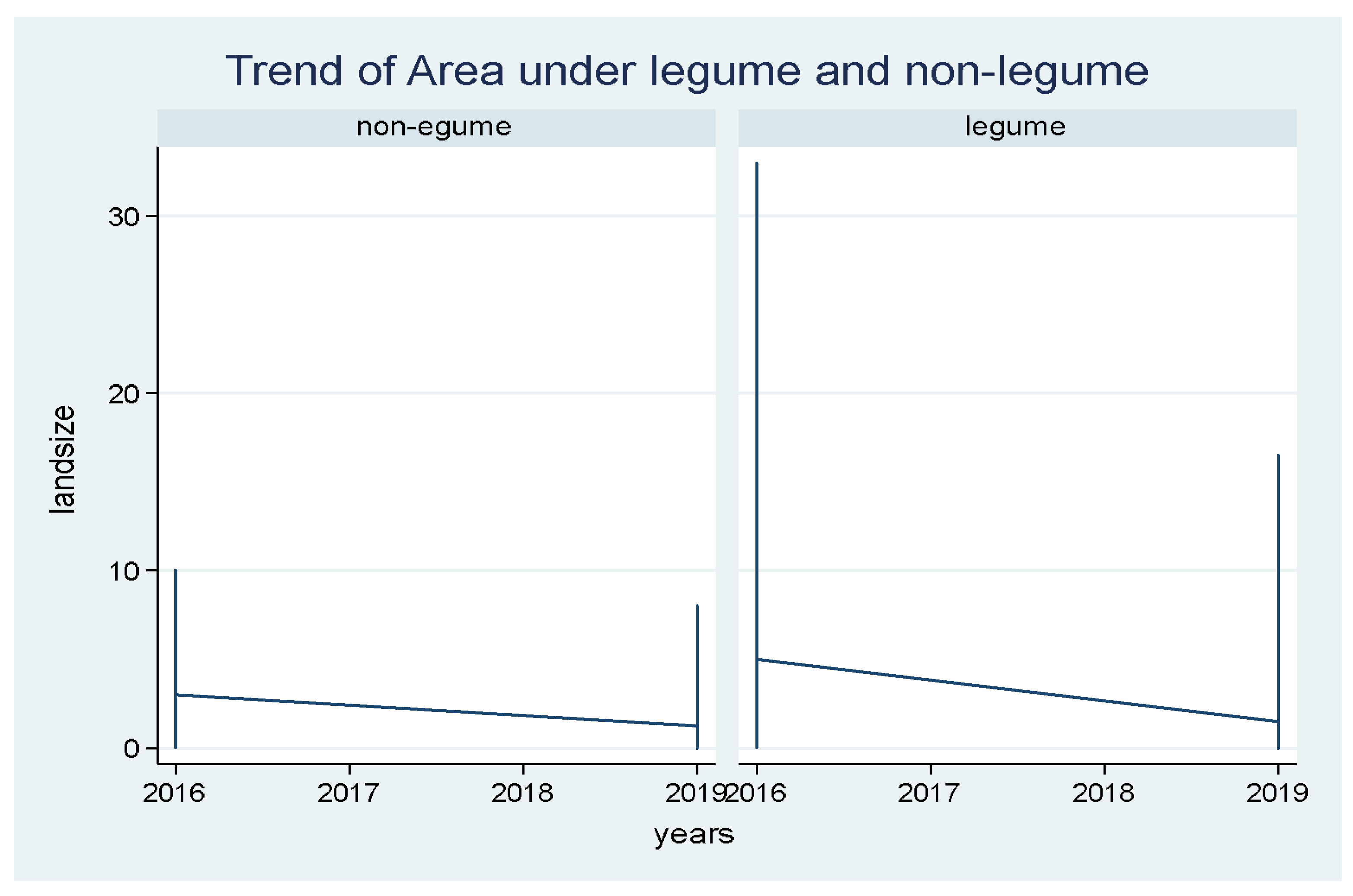
Figure 3.
Area allocation to legumes and non-legumes.
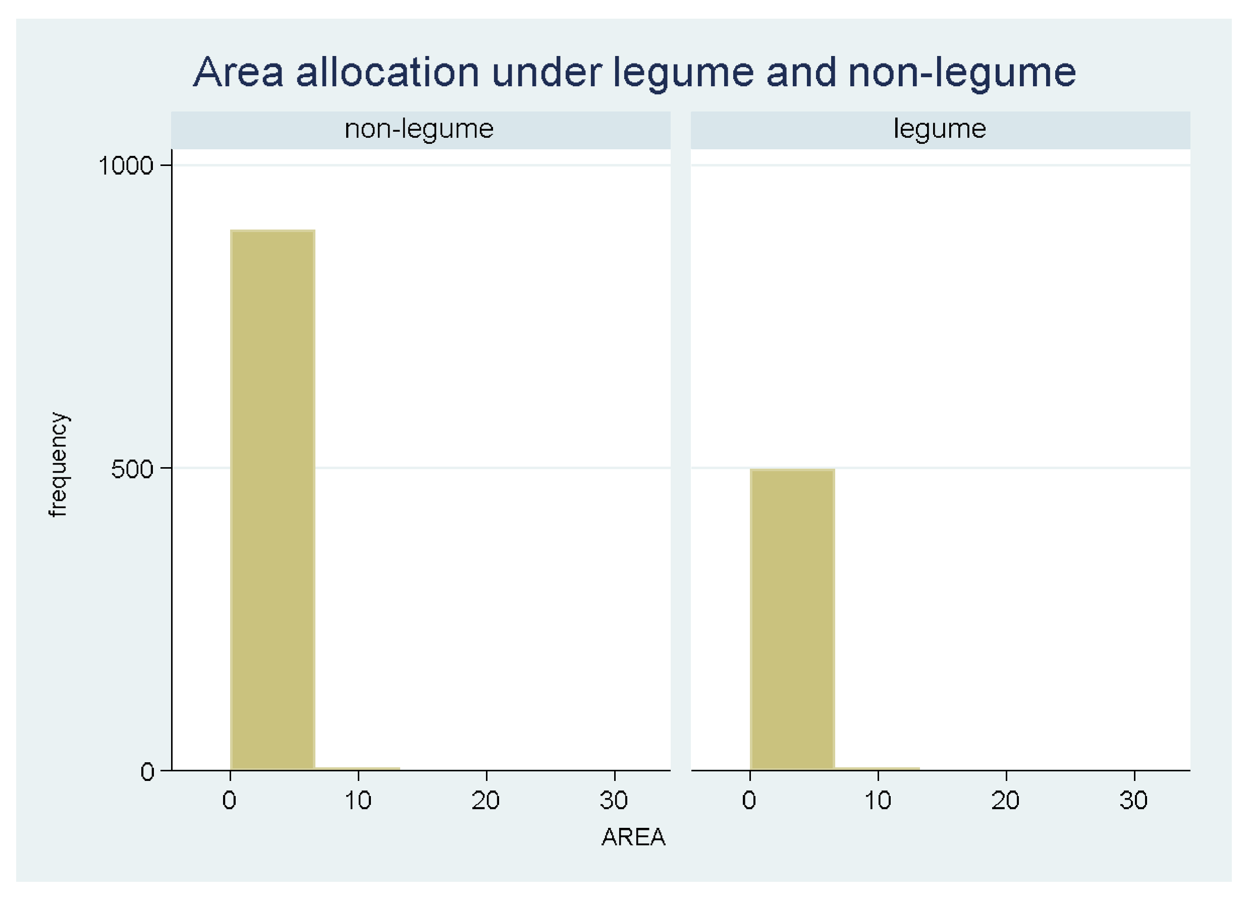
Figure 6.
Trend of household expenditure by adoption.
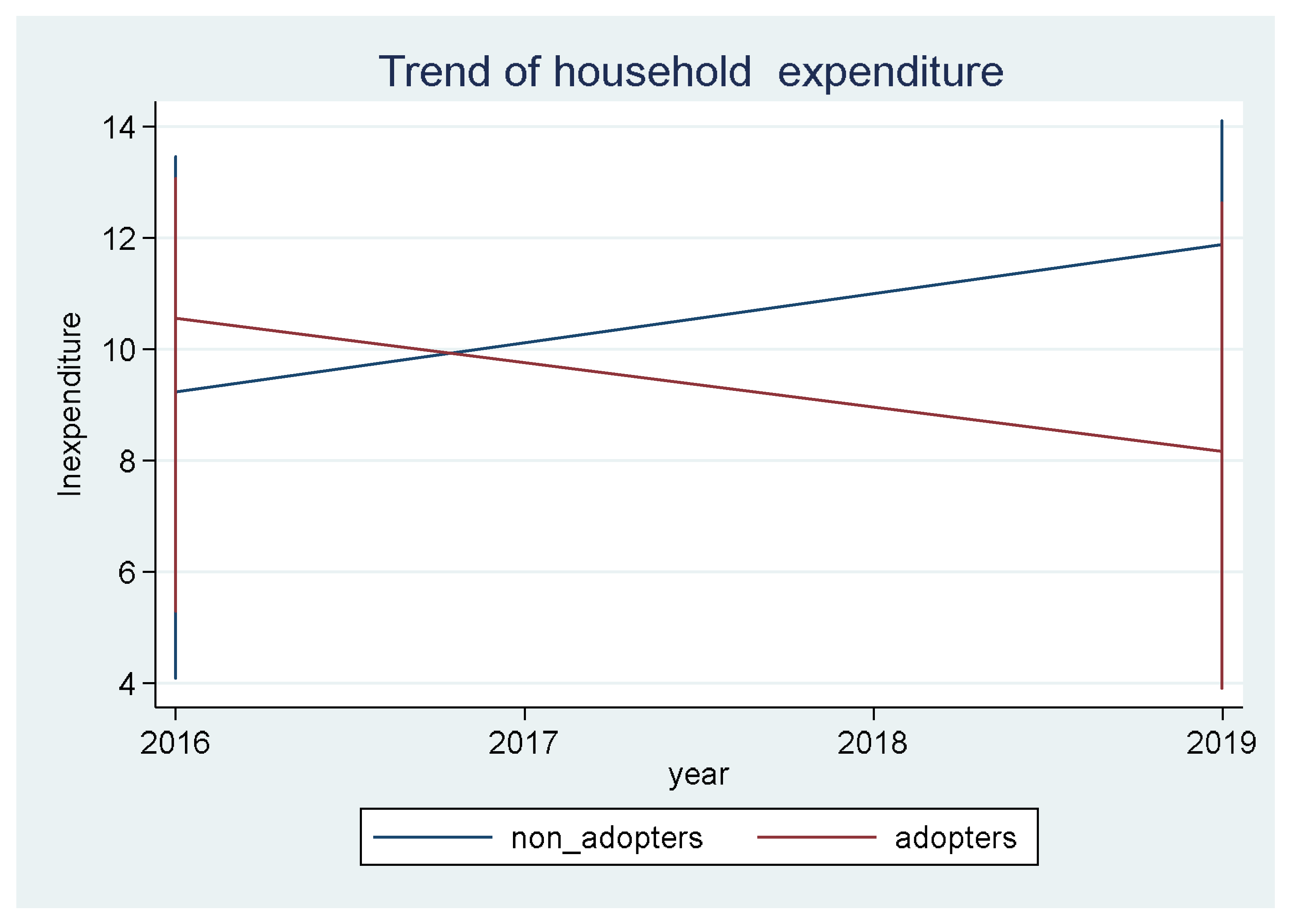
Figure 7.
Trend of household Consumption by adoption.
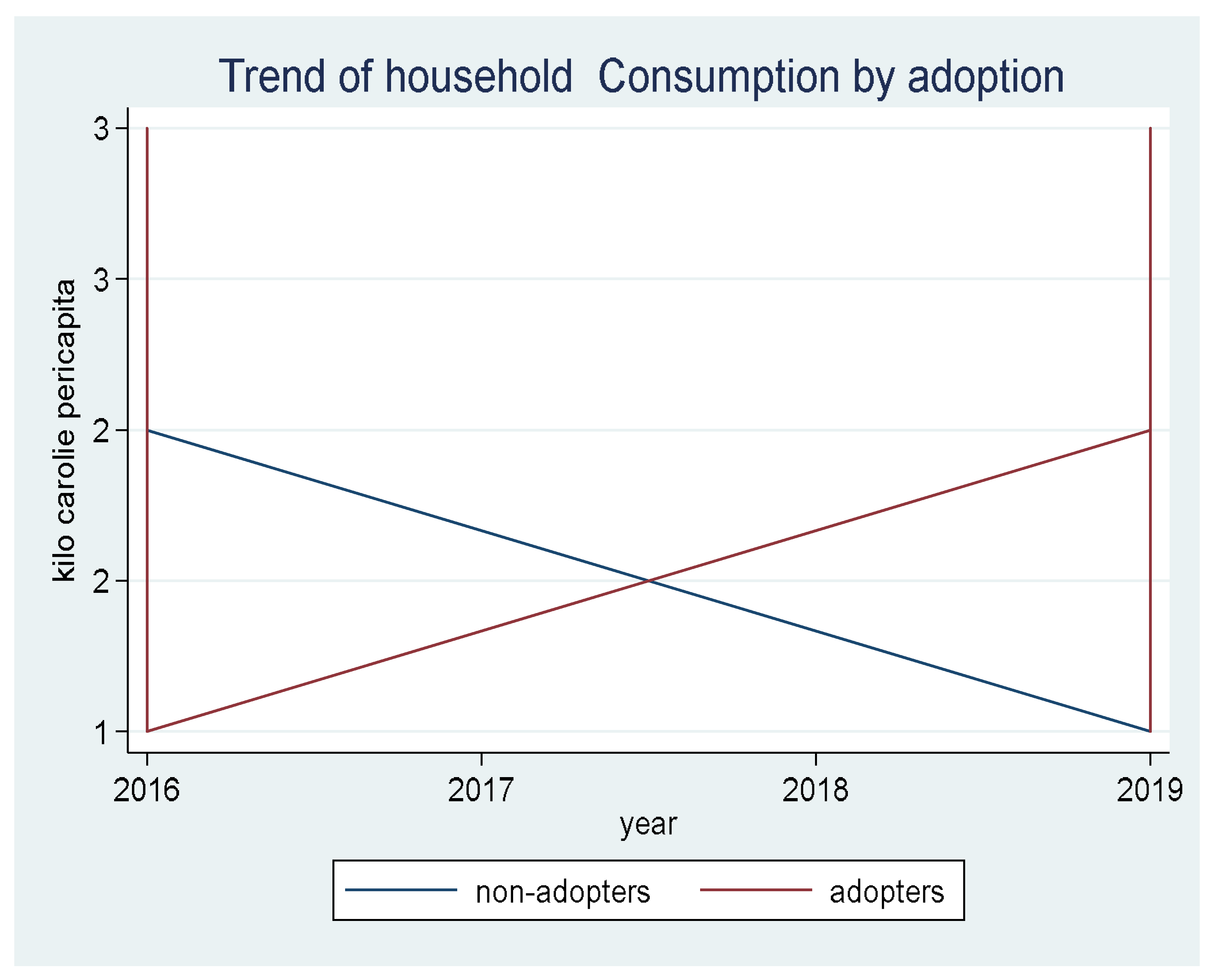
Table 1.
Pproportion of sampling in the Regions.
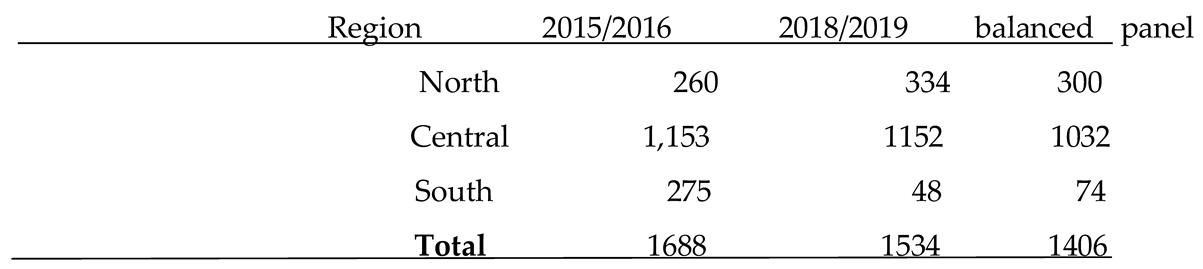
Table 2.
Descriptive statistics for variables used in the econometric analysis.
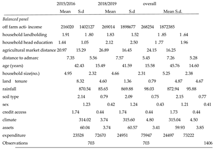
Table 3.
Socio-economic characteristics of adopters and non-adopters.

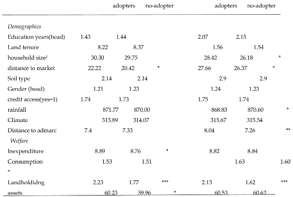
Table 9.
Periodic Analysis; Adoption impact on household Asset holding: random effects estimation.
| Variable |
Parameter | Coefficient | Robust Std. Err. | p -Value |
|---|---|---|---|---|
| Constant Gender |
β0 β1 |
54.71*** 1.240*** |
1.329 0.326 |
0.000 0.000 |
| Credit access Education level Off farm activity dummy Region Year16(2016=1) |
β2 β3 β4 β5 β6 |
0.630** -0.516*** -1.726** 1.769*** -0.715** |
0.346 0.127 0.596 0.346 0.319 |
0.070 0.000 0.004 0.000 0.025 |
| Number of observations | 507 | |||
| R-squared | 0.189*** | 3.492 | 0.000 |
***, **, *, mean significance at 1%, 5%, and 10% level, respectively.
Disclaimer/Publisher’s Note: The statements, opinions and data contained in all publications are solely those of the individual author(s) and contributor(s) and not of MDPI and/or the editor(s). MDPI and/or the editor(s) disclaim responsibility for any injury to people or property resulting from any ideas, methods, instructions or products referred to in the content. |
© 2024 by the authors. Licensee MDPI, Basel, Switzerland. This article is an open access article distributed under the terms and conditions of the Creative Commons Attribution (CC BY) license (http://creativecommons.org/licenses/by/4.0/).
Copyright: This open access article is published under a Creative Commons CC BY 4.0 license, which permit the free download, distribution, and reuse, provided that the author and preprint are cited in any reuse.


