Submitted:
14 July 2024
Posted:
15 July 2024
You are already at the latest version
Abstract
Background: Land use and land cover change (LULCC) in the Ruhuhu River Sub-Basin (RRSB), a crucial watershed within the Lake Nyasa Basin in Tanzania, poses a significant threat to water resource sustainability and ecological integrity. However, a lack of comprehensive data on long-term LULCC trends has hindered effective conservation efforts.
Methods: This study utilized Landsat 5 TM and Landsat 8 OLI data within Google Earth Engine to quantify LULCC dynamics from 1990 to 2023. Six land cover classes were analyzed: water, forest, barren land, grassland, shrubland, and farmland.
Results: Results revealed a substantial decline in forest cover (56.92% to 28.60%), primarily converted to farmland (2.99% to 20.22%). Shrubland expanded initially but then declined, while barren land steadily increased. These changes have profound implications for water resources, biodiversity, and ecosystem services within the RRSB and the broader Lake Nyasa Basin.
Conclusions: This research highlights the urgency of implementing sustainable land management practices to mitigate the adverse impacts of LULCC in the RRSB. The high classification accuracies achieved (90.9% to 98.7%) validate the robustness of the methodology. This study provides crucial insights for policymakers, land managers, and conservation practitioners, emphasizing the need for targeted interventions to promote sustainable land use and ensure the long-term resilience of the RRSB ecosystem.
Keywords:
Land Use and Land Cover Change
; Ruhuhu River Sub-Basin
; Remote Sensing
; Lake Nyasa/Niassa/Malawi
Introduction
Water catchments are essential for global sustainability, providing freshwater resources, and supporting diverse ecosystems and human activities(Creighton et al., 2021). However, their integrity is increasingly threatened by population growth, climate change, natural disasters, and unsustainable land-use practices(Näschen et al., 2019). Land use and land cover change (LULCC) within these catchments, often driven by agricultural expansion, overgrazing, logging, and mining, is a major factor in the degradation of vital ecosystems. LULCC has been shown to directly affect terrestrial and aquatic environments (Tuholske et al., 2017) by altering runoff patterns, sediment loads, water quality, biodiversity, and ecosystem services, potentially leading to flooding and other adverse effects (Tesfaw et al., 2023).
The Lake Nyasa Basin, shared by Malawi, Tanzania, and Mozambique, is one such catchment that faces these challenges (Yihdego and Paffard, 2016). The Ruhuhu River, its largest tributary, has experienced environmental degradation, flooding, and disruptions to fish breeding grounds owing to human activities and climate change, threatening the endemic species of the basin (Chavula et al., 2023).
The lack of baseline LULC data for the Ruhuhu sub-catchment (RRSB) further complicates efforts to identify and mitigate these threats. To address this knowledge gap, this study utilised remote sensing and GIS technologies, specifically the Google Earth Engine (GEE) and Landsat 5TM/8 OLI datasets, to assess LULC change dynamics in the RRSB from 1990 to 2023. This approach, which has proven effective in similar studies(Hamel et al., 2015; Musyoka et al., 2023; Pullanikkatil et al., 2016), will provide crucial information for decision makers to promote sustainable land management practices and safeguard this critical water catchment.
Methods
Location of Study Area
The Ruhuhu River Sub-Basin (RRSB) is situated within the Lake Nyasa Basin in southern Tanzania, encompassing an area of approximately 14,070 km2, making it the largest tributary of Lake Nyasa (Chavula et al., 2023). The catchment extends between latitudes 9°40'00″ " S and 11°00'00" S and longitudes 34°40'00"E and 35°40'00"″ E (Figure 1). Elevations within the catchment range from 473.58 to 2485.21 meters above sea level. This catchment drains into Lake Nyasa (also known as Lake Malawi or Lake Niassa), providing a crucial habitat for spawning diverse endemic fish species and significantly contributing to the ecological richness of the broader Lake Nyasa Basin. (Yihdego & Paffard, 2016).
Data Acquisition and Preprocessing
Landsat 5 TM and Landsat 8 OLI data from the Google Earth Engine (GEE) were used to analyse land use and land cover changes in the Ruhuhu River Sub-Basin (RRSB)(Akbar et al., 2019; Roy & Bari, 2022). Data collection was constrained by factors such as deciduous vegetation, cloud cover, and non-photosynthetic vegetation(Vinya et al., 2018). To address these challenges, zero-cloud images from the dry season (April-August) with the highest quality were selected for 1990, 2005, 2013, and 2023 (Table 1). Google Earth Pro aided in collecting training and validation data(Koskinen et al., 2019a; Saah et al., 2019). Preprocessing, including atmospheric correction, radiometric calibration, and geometric correction, was also performed in the GEE (Mashala et al., 2023).
Land Use and Land Cover Classification
LULCs were classified into six predefined categories (Table 2), as recommended by the UNFCCC Good Practice Guide: water, forest, barren, grass, shrub, and farms (de Deus & Tenedório, 2021; Liu et al., 2020; Nguyen et al., 2020). We supplemented our LULC classification with field visits and the use of high-resolution images to collect training and ground-truth data, as suggested in other studies (Jew et al., 2016). Moreover, this study applied the smile random forest (SRF) classification algorithm scripts ("ee.classifier.smileRandomForest") available in GEE (Schirpke et al., 2020a). Previous studies have indicated that the SRF classifier is among the superior supervised classification techniques (Cheng et al., 2023) when compared with Maximum Likelihood, Random Forest, and Support Vector Machines(Blicharska et al., 2020; Haque & Basak, 2017).
Ground Truthing and Validation
The ground truthing datasets were collected using the open-source platform, which is free and reliable, and is known as the Open-Foris Collect Earth tool operating in Google Earth Pro(Koskinen et al., 2019b). The collected ground-truthing datasets were divided into two groups: 60% were used as training data for performing LULC, and the remaining 40% were used for validation procedures following established practices(Zeng et al., 2020). Table 3 displays the training and validation data samples per Land Use/Land Cover Category for 1990, 2005, 2013, and 2023.
Results
Accuracy Assessment
The accuracy of the LULC maps was assessed using the confusion matrix method, a standard approach for validating thematic maps derived from supervised classifications (FAO, 2016). This involved comparing the classified LULC maps with 40% of the collected data that were not used in the classification process (Zhang et al., 2019). User accuracy (UA), producer accuracy (PA), overall accuracy (OA), and kappa coefficient (KC) were calculated using GEE scripts (Calderón-Loor et al., 2021; Ngoc Thach et al., 2018). Previous studies suggested that the allowable limit for approving LULC classified maps is when the overall accuracy reaches at least 80% (Ge et al., 2020; Koskinen et al., 2019a; Wickham et al., 2017). The high accuracy values obtained in this study (ranging from 90.9% to 98.7% overall accuracy, with kappa coefficients of 0.885–0.982) strongly support the robustness and reliability of the LULC classification approach. These results exceeded the recommended thresholds for reliable LULC mapping, validating the use of the generated thematic maps for further analysis and interpretation in subsequent sections.

Table 4.
Accuracy Assessment Results for LULC Maps.
| Accuracy Assessment | ||
|---|---|---|
| Year | OA | KC |
| 1990 | 0.967 | 0.956 |
| 2005 | 0.987 | 0.982 |
| 2013 | 0.983 | 0.976 |
| 2023 | 0.909 | 0.885 |
Land Use and Land Cover (1990-2023)
Analysis of the LULC patterns in the RRSB for 1990, 2005, 2013, and 2023 (Table 5, Figure 2) revealed significant shifts in land cover over 34 years (Figure 3). In 1990, forests dominated the landscape, covering 56.92% of the study area, followed by shrublands (29.2%), and barren land (5.29%). By 2005, forest cover had expanded to 62.9%, whereas that of the shrublands had decreased to 22.8%. However, a notable trend emerged in 2013, with shrublands becoming the dominant land cover type (52.4%), surpassing forests (21.80%). Farmland expanded considerably during this period, covering 15.3% of the total area. In 2023, shrublands will remain dominant (32.2%), followed closely by forests (28.6%) and farmland (21.40%). Barren land continued to increase, reaching 14%, whereas grasslands and water bodies experienced relatively minor fluctuations over the study period.
LULC Change Matrix (2013-2023)
The LULC change matrix for 2013-2023 (Table 6) provides a detailed account of the dynamic land cover transformations in the RRSB. While most water bodies (7131.958 ha) remained relatively stable, a notable portion (7990.108 ha) transitioned to other land cover types, primarily forest (572.6698 ha), barren land (107.2799 ha), and shrubland (121.4999 ha). This suggests a complex interplay between the factors that influence the hydrological dynamics of the catchment. A significant portion of the barren land (94751.16 ha) has undergone transitions, predominantly to shrubland (26302.49 ha), farmland (15478.47 ha), and forest (11611.62 ha). This pattern could reflect natural processes such as ecological succession and anthropogenic drivers such as land abandonment and reforestation. Forests, initially the most extensive land cover type, underwent the largest area of change (308027.6 ha) during this period. Substantial conversions to farmland (54598.31 ha) and shrubland (28080.71 ha) were observed, highlighting significant deforestation pressures in the RRSB. Grassland areas also exhibited notable changes, with a considerable portion (46272.59 ha) transitioning primarily to shrublands (14705.55 ha) and farmlands (13587.75 ha). This could be attributed to factors such as overgrazing, agricultural expansion, or changes in precipitation patterns. Farmland experienced both expansion and contraction, with a substantial increase (215519 ha) attributed mainly to conversions from forest (6598.348 ha) and shrubland (115706.5 ha). This highlights the intensification of agricultural activities in the region. Shrubland, the most extensive land cover type in 2013, underwent substantial changes, with large areas transitioning to farmland (174283.2 ha) and forest (173750.4 ha), possibly indicating shifts in land management practices or ecological succession processes. Overall, the LULC change matrix for the RRSB revealed a complex landscape of interconnected transformations, with various land cover types experiencing gains and losses. These changes likely reflect the interplay between multiple drivers, including anthropogenic activities, climatic variations, and natural ecological processes. Understanding these dynamics is crucial for developing effective regional land management and conservation strategies.
Discussion
The LULC change matrix for the Ruhuhu River Sub-Basin (RRSB) from 2013 to 2023 revealed a complex and dynamic landscape transformation. Although the water bodies experienced relatively minor changes, the other land cover categories underwent substantial shifts, reflecting both natural ecological processes and anthropogenic influences.
A significant decline in forest cover, primarily due to conversion to farmland, is a primary concern. This deforestation trend aligns with the broader patterns observed in sub-Saharan Africa, where agricultural expansion is a primary driver of forest loss (Jew et al., 2016). The loss of forests in the RRSB, particularly in the Miombo woodlands, threatens biodiversity and compromises the ecological integrity of the catchment and the broader Lake Nyasa Basin. Reduced forest cover can lead to soil erosion, decreased water quality, and the disruption of critical habitats for fish and other wildlife. The concurrent expansion of farmland highlights the increasing pressure on land resources to meet the demands of the growing population and changing livelihoods. While agriculture is crucial for local economies, unsustainable practices, such as overgrazing cultivation along riverbanks, can exacerbate soil erosion, sedimentation, and water pollution (Kitalyi et al., 2013). The increased use of fertilisers and pesticides in agriculture poses additional threats to aquatic ecosystems and biodiversity. The continuous increase in barren land, primarily due to abandoned farms, mining activities, and urbanisation, raises concerns about land degradation and potential long-term impacts on water resources (Gedefaw et al., 2023; Zhou et al., 2018). Exposure of bare soil to erosive forces can lead to the loss of fertile topsoil and contribute to sedimentation in rivers and lakes. Fluctuations in shrubland and grassland cover likely reflect a combination of factors, including changes in land management practices, agricultural expansion, and natural vegetation dynamics. These changes can have significant implications for biodiversity, water regulation, and erosion control, because shrublands and grasslands play crucial roles in maintaining ecosystem health (Lynch et al., 2016; Syampungani et al., 2016). Overall, the observed LULC changes in the RRSB underscore the need for integrated land and water management strategies that balance the needs of local communities with those of critical ecosystems. Sustainable agricultural practices, reforestation efforts, and measures to control soil erosion and water pollution are essential for ensuring the long-term health and productivity of the catchment. Furthermore, continued monitoring of LULC changes is crucial for assessing the effectiveness of these interventions and adapting management strategies to evolving landscapes.
Conclusion and Recommendations
This study has provided a comprehensive assessment of land use and land cover (LULC) dynamics in the Ruhuhu River Sub-Basin (RRSB) over 34 years (1990-2023). The analysis revealed substantial transformations in LULC patterns, primarily characterised by deforestation, agricultural expansion, and the growth of barren land. These changes have significant implications for a region's ecological integrity and socioeconomic well-being. The decline in forest cover and the corresponding expansion of farmland underscores the urgent need for sustainable land management practices that balance agricultural productivity with the conservation of critical ecosystems. The increasing prevalence of barren land, attributed to land abandonment, mining activities, and urbanisation, necessitates interventions to restore degraded land and mitigate soil erosion. Fluctuations in shrubland and grassland cover highlight the dynamic nature and vulnerability of these ecosystems to anthropogenic and environmental pressures. Efforts to rehabilitate and protect natural habitats are crucial for maintaining biodiversity, regulating water resources, and preventing soil erosion.
Although relatively minor, the observed changes in water bodies raise concerns about the long-term impacts of land-use change on water quality and availability. Continuous monitoring and assessment of water resources are essential to ensure the sustainable management of this vital resource.
Based on these findings, the following recommendations are proposed:
- Promote sustainable agricultural practices: Encourage the adoption of agroforestry, conservation agriculture, and other sustainable farming techniques that minimise environmental impacts and maintain soil fertility.
- Implementing reforestation and afforestation programs: Prioritise the restoration of degraded forest areas and establish new forest plantations to enhance carbon sequestration, biodiversity, and water regulation.
- Enforce regulations on land use and mining activities: Strengthen enforcement of existing laws and regulations to prevent unsustainable land use practices, including deforestation, overgrazing, and uncontrolled mining.
- Invest soil conservation measures: Promote terracing, contour farming, and other soil conservation practices to reduce soil erosion and maintain soil productivity.
- Establish a comprehensive monitoring and evaluation system: Develop a robust system for monitoring LULC changes, water quality, and other environmental indicators to assess the effectiveness of interventions and inform adaptive management strategies.
- Enhance community engagement and awareness: Engage local communities in land-use planning and decision-making processes and raise awareness about the importance of sustainable land management practices for their livelihoods and the environment.
Author Contributions
Sosteness Jerome Nakamo led the conceptualisation, methodology design, data collection, analysis, and preparation of the original draft. He also conducted LULC mapping using the Google Earth Engine and managed project administration and funding acquisition. Hellen Francis and Fadhili Mgumia contributed to the literature review and provided valuable insights and discussions throughout the research process.
Funding
This research received no specific grants from any funding agency in the public, commercial, or not-for-profit sectors.
Data Availability Statement
The data that support the findings of this study are available from the corresponding author upon reasonable request.
Acknowledgements
The authors sincerely thank God for guidance throughout this study. They also acknowledge the invaluable contributions of all individuals who participated in the study, whose dedication and support were instrumental in completing this project.
Conflicts of Interest
The authors declare that they have no known competing financial interests or personal relationships that could have appeared to influence the work reported in this paper.
References
- Akbar, T. A., Hassan, Q. K., Ishaq, S., Batool, M., Butt, H. J., & Jabbar, H. (2019). Investigative spatial distribution and modelling of existing and future urban land changes and their impact on urbanisation and the economy. Remote Sensing, 11(2). [CrossRef]
- Blicharska, M., Angelstam, P., Giessen, L., Hilszczański, J., Hermanowicz, E., Holeksa, J., Jacobsen, J. B., Jaroszewicz, B., Konczal, A., Konieczny, A., Mikusiński, G., Mirek, Z., Mohren, F., Muys, B., Niedziałkowski, K., Sotirov, M., Stereńczak, K., Szwagrzyk, J., Winder, G. M., … Winkel, G. (2020). Between biodiversity conservation and sustainable forest management: A multidisciplinary assessment of the emblematic Białowieża Forest case. Biological Conservation, 248(April), 108614. [CrossRef]
- Chavula, G. M. S., M’balaka, M. S., Gondwe, E., Ngochera, M., Halafo, J. S., Shechonge, A. H., Gabagambi, N. P., Mbonde, A. S., Banda, D., Muyumbana, N., Lawrence, T. J., Ajode, M. Z., Smith, S., Jonasse, C., Kanyerere, G. Z., Ngatunga, B.P. (2023). Lake Malawi/Niassa/Nyasa basin: Status, challenges, and research needs. Journal of Great Lakes Research, 49(October). [CrossRef]
- Cheng, K., Su, Y., Guan, H., Tao, S., Ren, Y., Hu, T., Ma, K., Tang, Y., & Guo, Q. (2023). Mapping of China’s planted forests using high-resolution imagery and massive amounts of crowdsourced samples. ISPRS Journal of Photogrammetry and Remote Sensing, 196(April 2022), 356–371. [CrossRef]
- Creighton, C., Waterhouse, J., & Day, J. C., & Brodie, J. (2021). Criteria for effective regional scale catchment to reef management: A case study of Australia’s Great Barrier Reef. Marine Pollution Bulletin, 173(PA), 112882. [CrossRef]
- de Deus, R. F., & Tenedório, J. A. (2021). Coastal land use and land cover change trajectories: Are they sustainable? Sustainability (Switzerland), 13(16). [CrossRef]
- Frost, P. (1996). The Ecology of Miombo Woodlands. The Miombo in Transition: Woodlands and Welfare in Africa. http://books.google.com/books?hl=nl&lr=&id=rpildJJVdU4C&pgis=1.
- Hamel, P., Chaplin-Kramer, R., Sim, S., & Mueller, C. (2015). A new approach to modelling the sediment retention service (InVEST 3.0): Case study of the Cape Fear catchment, North Carolina, USA. Science of The Total Environment, 524–525, 166–177. [CrossRef]
- Haque, M. I., & Basak, R. (2017). Land cover change detection using GIS and remote sensing techniques: A spatio-temporal study on Tanguar Haor, Sunamganj, Bangladesh. Egyptian Journal of Remote Sensing and Space Science, 20(2), 251–263. [CrossRef]
- Jew, E. K. K., Dougill, A. J., Sallu, S. M., O’Connell, J., & Benton, T. G. (2016). Miombo woodland under threat: consequences for tree diversity and carbon storage. Forest Ecology and Management, 361, 144–153. [CrossRef]
- Koskinen, J., Leinonen, U., Vollrath, A., Ortmann, A., Lindquist, E., d’Annunzio, R., Pekkarinen, A., & Käyhkö, N. (2019a). Participatory mapping of forest plantations was performed using Open Foris and Google Earth Engine. ISPRS Journal of Photogrammetry and Remote Sensing, 148(October 2018), 63–74. [CrossRef]
- Koskinen, J., Leinonen, U., Vollrath, A., Ortmann, A., Lindquist, E., d’Annunzio, R., Pekkarinen, A., & Käyhkö, N. (2019b). Participatory mapping of forest plantations was performed using Open Foris and Google Earth Engine. ISPRS Journal of Photogrammetry and Remote Sensing, 148, 63–74. [CrossRef]
- Liu, S., Li, X., Chen, D., Duan, Y., Ji, H., Zhang, L., Chai, Q., & Hu, X. (2020). Understanding Land use/land dynamics and impacts of human activities in the Mekong Delta over the last 40 years. Global Ecology and Conservation, 22. [CrossRef]
- Mashala, M. J., Dube, T., Mudereri, B. T., Ayisi, K. K., & Ramudzuli, M. R. (2023). A systematic review on advances in remote sensing for assessing and monitoring land use and land cover change impacts on surface water resources in semi-arid tropical environments. Remote Sensing, 15(16). [CrossRef]
- Musyoka, F. K., Strauss, P., Zhao, G., Strohmeier, S., Mutua, B. M., and Klik, A. (2023). Evaluation of the impact of sustainable land management practices on water quality in an agricultural catchment in Lower Austria using SWAT. Environmental Monitoring and Assessment, 195(4). [CrossRef]
- Näschen, K., Diekkrüger, B., Evers, M., Höllermann, B., Steinbach, S., & Thonfeld, F. (2019). The Impact of Land Use/Land Cover Change (LULCC) on Water Resources in a Tropical Catchment in Tanzania under Different Climate Change Scenarios. Sustainability (Switzerland), 11(24). [CrossRef]
- Nguyen, H. T. T., Doan, T. M., Tomppo, E., & McRoberts, R. E. (2020). Land use/land cover mapping using multitemporal sentinel-2 imagery and four classification methods-A case study from Dak Nong, Vietnam. Remote Sensing, 12(9), 1–27. [CrossRef]
- Pullanikkatil, D., Palamuleni, L., Ruhiiga, T. (2016). Assessment of land use change in Likangala River catchment, Malawi: A remote sensing and DPSIR approach. In Applied Geography (Vol. 71, pp. 9–23). Elsevier Ltd. [CrossRef]
- Roy, B., & Bari, E. (2022). The relationship between land surface temperature and landscape features was examined using spectral indices with the Google Earth Engine. Heliyon, 8(9), e10668. [CrossRef]
- Saah, D., Johnson, G., Ashmall, B., Tondapu, G., Tenneson, K., Patterson, M., Poortinga, A., Markert, K., Quyen, N. H., San Aung, K., Schlichting, L., Matin, M., Uddin, K., Aryal, R. R., Dilger, J., Lee Ellenburg, W., Flores-Anderson, A. I., Wiell, D., Lindquist, E., … Chishtie, F. (2019). Collect Earth: An online tool for systematic reference data collection in land cover and use applications. Environmental Modeling and Software, 118, 166–171. [CrossRef]
- Schirpke, U., Tscholl, S., & Tasser, E. (2020a). Spatiotemporal changes in ecosystem service values: effects of land-use changes from past to future (1860–2100). Journal of Environmental Management, 272. [CrossRef]
- Schirpke, U., Tscholl, S., & Tasser, E. (2020b). Spatiotemporal changes in ecosystem service values: effects of land-use changes from past to future (1860–2100). Journal of Environmental Management, 272. [CrossRef]
- Tesfaw, B. A., Dzwairo, B., & Sahlu, D. (2023). Assessments of the impacts of land use/land cover change on water resources: Tana Sub-Basin, Ethiopia. Journal of Water and Climate Change, 14(2), 421–441. [CrossRef]
- Tuholske, C., Tane, Z., López-Carr, D., Roberts, D., & Cassels, S. (2017). Thirty years of land use/cover change in the Caribbean: Assessing the relationship between urbanisation and mangrove loss in Roatán, Honduras. Applied Geography, 88, 84–93. [CrossRef]
- Vinya, R., Malhi, Y., Brown, N. D., Fisher, J. B., Brodribb, T., & Aragão, L. E. O. C. (2018). Seasonal changes in plant-water relations influence patterns of leaf display in Miombo woodlands: Evidence of water conservation strategies. Tree Physiology, 39(1), 104–112. [CrossRef]
- Yang, Z., Willis, P., & Mueller, R. (2008). Impact of Band-Ratio-Enhanced Awifs Image on Crop Classification Accuracy. Pecora 17 – The Future of Land Imaging…Going Operational, 11.
- Yihdego, Y. & Paffard, A. (2016). Hydro-engineering solution for sustainable groundwater management at a cross border region: case of Lake Nyasa/Malawi basin, Tanzania. International Journal of Geo-Engineering, 7(1). [CrossRef]
- Zeng, H., Wu, B., Wang, S., Musakwa, W., Tian, F., Mashimbye, Z. E., Poona, N., & Syndey, M. (2020). A synthesising land-cover classification method based on Google Earth engine: A case study in Nzhelele and Levhuvu catchments, South Africa. Chinese Geographical Science, 30(3), 397–409. [CrossRef]
Figure 1.
Map of the Ruhuhu River Sub-Basin (RRSB) within Lake Nyasa Basin, Tanzania, indicating its geographical location, elevation range, and drainage into Lake Nyasa.
Figure 1.
Map of the Ruhuhu River Sub-Basin (RRSB) within Lake Nyasa Basin, Tanzania, indicating its geographical location, elevation range, and drainage into Lake Nyasa.
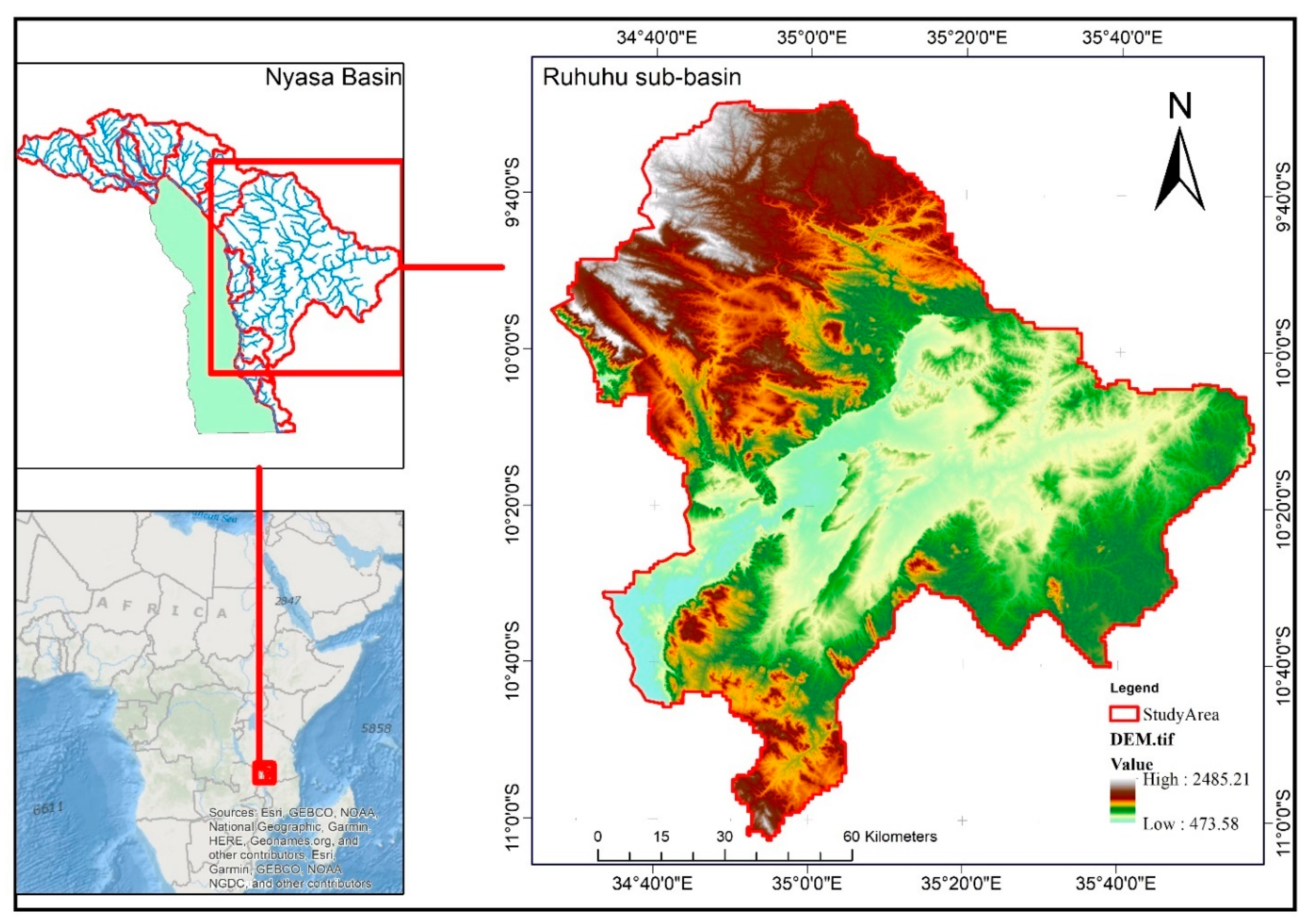
Figure 3.
a-d. Land use and land cover (LULC) maps of the Ruhuhu River Sub-Basin (RRSB) for (a) 1990, (b) 2005, (c) 2013, and (d) 2023, depicting the spatial distribution of six classified LULC categories: water (blue), forest (dark green), barren land (light brown), grassland (light green), shrubland (yellow), and farmland (brown).
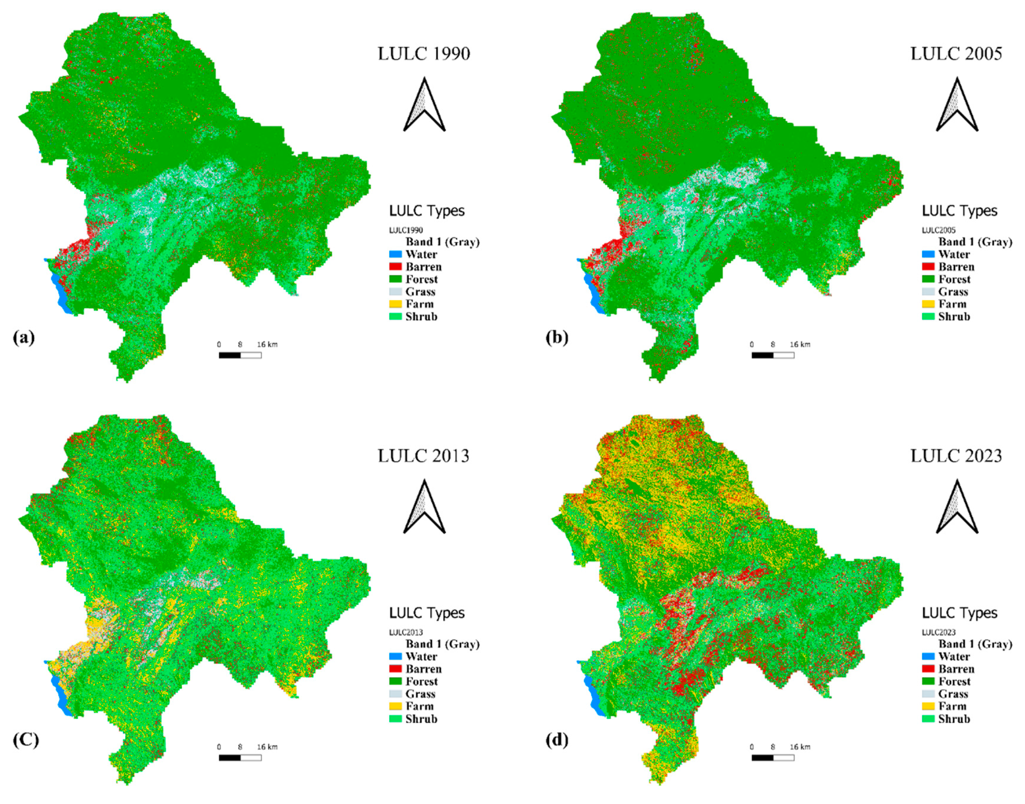
Figure 4.
a-d. LULC change matrices for the Ruhuhu River Sub-Basin (RRSB) illustrating the spatial distribution and transitions of land use and land cover (LULC) categories between (a) 1990-2005, (b) 2005-2013, (c) 2013-2023, and (d) the cumulative changes from to 1990-2023.
Figure 4.
a-d. LULC change matrices for the Ruhuhu River Sub-Basin (RRSB) illustrating the spatial distribution and transitions of land use and land cover (LULC) categories between (a) 1990-2005, (b) 2005-2013, (c) 2013-2023, and (d) the cumulative changes from to 1990-2023.
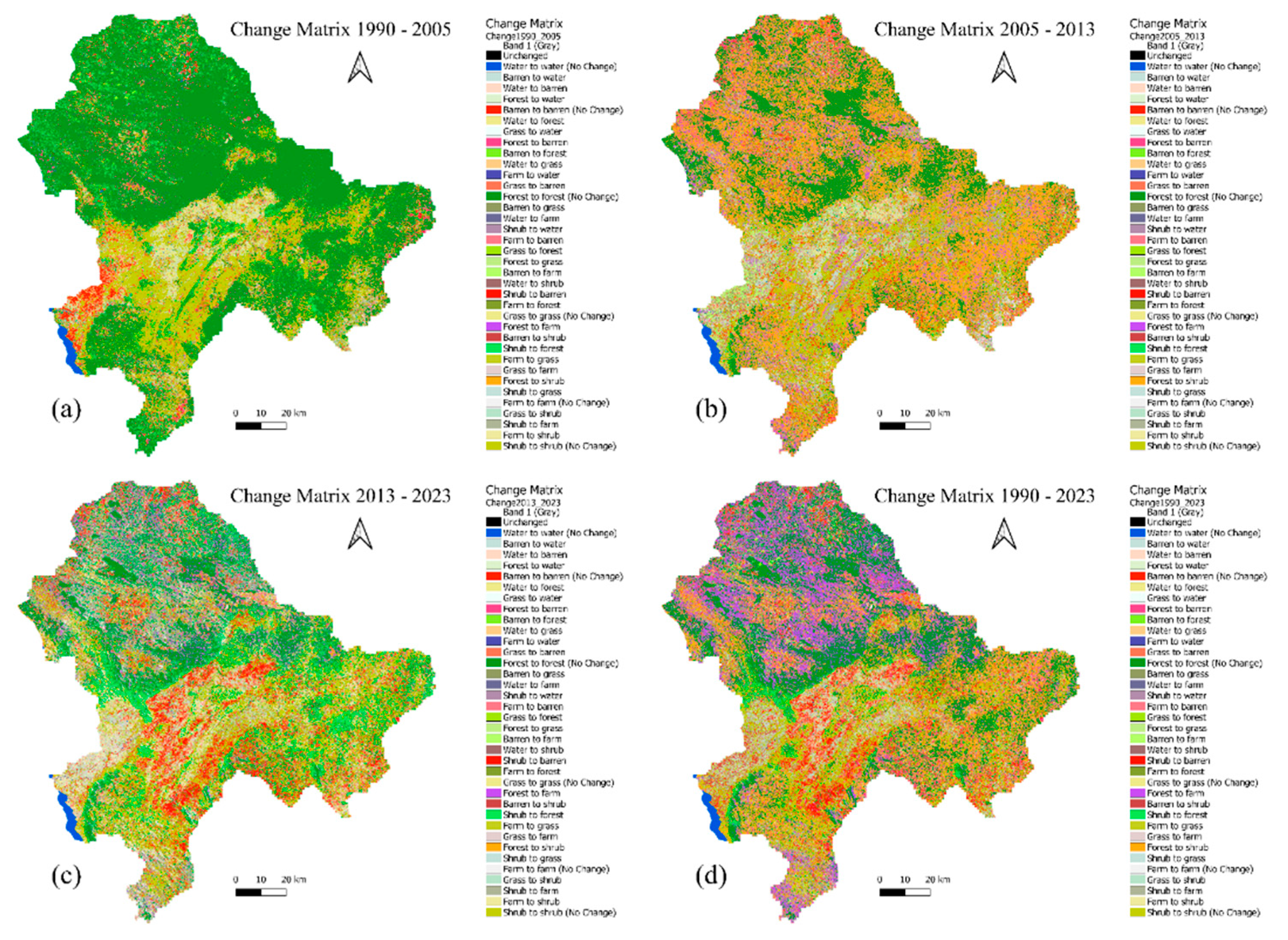
Table 1.
Data collected, acquisition date, resolution, and sources or provider Satellite Image.
| Data types | Acquisition Date | Resolution | Source/Provider |
|---|---|---|---|
| Landsat 5TM | Medium (1990, 2005) | Raster (30) | Google Earth Engine |
| Landsat 8 OLI | Medium (2013, 2013) | Raster (30) | Google Earth Engine |
| Google Earth Pro imagery | 2007 & 2016 | Raster < 2 | Google Earth Pro/Collect Earth |
| Study Area (Boundary) | 2023 | Vector | Lake Nyasa Water Body |
Table 2.
Land Use and Land Cover (LULC) Classes in the Ruhuhu River Sub-Basin.
| S/N | Class | Definition |
|---|---|---|
| 1 | Water | Rivers, lakes, swamps, dams, and wetlands. |
| 2 | Forest | Natural forests (e.g., Miombo woodlands) and forest plantations. |
| 3 | Barren Land | Abandoned farms, mining sites, rocks, outcrops, sand, beaches, and residential areas. |
| 4 | Grass | Areas with short vegetation and grass near rivers and grazing lands. |
| 5 | Shrub | Vegetation with low foliage and shorter height. |
| 6 | Farms | Areas used for seasonal and perennial crops. |
Table 3.
Training and validation datasets for years 1990 – 2023.
| Year | Number Training samples | ||
|---|---|---|---|
| Collected samples | Training | Validation | |
| 1990 | 12,228 | 7,426 | 4,802 |
| 2005 | 12,186 | 7,330 | 4,856 |
| 2013 | 10,825 | 6,421 | 4,404 |
| 2023 | 2,767 | 1,929 | 838 |
Table 5.
Land Use, Land Cover Area (hectares), and Percentage Change in the Ruhuhu River Sub-Basin (1990-2023).
Table 5.
Land Use, Land Cover Area (hectares), and Percentage Change in the Ruhuhu River Sub-Basin (1990-2023).
| LULCC Categories | 1990 | 2005 | 2013 | 2023 | LULC Change | ||||||
|---|---|---|---|---|---|---|---|---|---|---|---|
| Ha | % | Ha | % | Ha | % | Ha | % | 1990 - 2005 | 2005 - 2013 | 2013 - 2023 | |
| Water | 8,100.29 | 0.57 | 9,353.76 | 0.66 | 7,932.98 | 0.56 | 8,125.35 | 0.58 | -1,253.47 | 1,420.78 | -192.37 |
| Barren | 74,633.77 | 5.29 | 93,768.60 | 6.65 | 94,638.01 | 6.71 | 196,961.90 | 14 | -19,134.83 | -869.41 | -102,323.89 |
| Forest | 802,836.60 | 56.9 | 886,990.15 | 62.9 | 307,557.19 | 21.8 | 403,407.20 | 28.6 | -84,153.55 | 579,432.96 | -95,850.01 |
| Grass | 71,023.60 | 5.04 | 81,707.10 | 5.79 | 46,255.82 | 3.28 | 46,412.12 | 3.29 | -10,683.50 | 35,451.28 | -156.30 |
| Farm | 42,147.82 | 2.99 | 16,580.68 | 1.18 | 215,234.48 | 15.3 | 301,825.37 | 21.4 | 25,567.14 | -198,653.80 | -86,590.89 |
| Shrub | 411,814.56 | 29.2 | 322,156.35 | 22.8 | 738,938.14 | 52.4 | 453,824.69 | 32.2 | 89,658.21 | -416,781.79 | 285,113.45 |
| Total | 1,410,556.63 | 100 | 1,410,556.63 | 100 | 1,410,556.63 | 100 | 1,410,556.63 | 100 | |||
Table 6.
LULC Change Matrix for the Ruhuhu River Sub-Basin (2013-2023) (in hectares).
| Change matrix 2013 - 2023 (Ha) | |||||||
|---|---|---|---|---|---|---|---|
| LULC TYPE | Water | Barren | Forest | Grass | Farm | Shrub | Total |
| Water | 7131.958 | 107.2799 | 572.6698 | 9.8099 | 46.8899 | 121.4999 | 7990.108 |
| Barren | 146.5199 | 36188.09 | 11611.62 | 5023.979 | 15478.47 | 26302.49 | 94751.16 |
| Forest | 381.1498 | 12669.93 | 211276.9 | 1020.6 | 54598.31 | 28080.71 | 308027.6 |
| Grass | 24.1199 | 8232.748 | 129.7799 | 9592.647 | 13587.75 | 14705.55 | 46272.59 |
| Farm | 116.2799 | 34994.96 | 6598.348 | 13859.55 | 44243.36 | 115706.5 | 215519 |
| Shrub | 380.1598 | 105118.6 | 173750.4 | 16944.84 | 174283.2 | 269382.4 | 739859.6 |
| Total | 8180.188 | 197311.6 | 403939.7 | 46451.42 | 302237.9 | 454299.2 | 1412420 |
Disclaimer/Publisher’s Note: The statements, opinions and data contained in all publications are solely those of the individual author(s) and contributor(s) and not of MDPI and/or the editor(s). MDPI and/or the editor(s) disclaim responsibility for any injury to people or property resulting from any ideas, methods, instructions or products referred to in the content. |
© 2024 by the authors. Licensee MDPI, Basel, Switzerland. This article is an open access article distributed under the terms and conditions of the Creative Commons Attribution (CC BY) license (http://creativecommons.org/licenses/by/4.0/).
Copyright: This open access article is published under a Creative Commons CC BY 4.0 license, which permit the free download, distribution, and reuse, provided that the author and preprint are cited in any reuse.


