
Submitted:
20 July 2024
Posted:
22 July 2024
You are already at the latest version
Abstract
Despite decades of conflict and political instability, drought has also severely affected Afghanistan’s rural population and agriculture sector. Agriculture is a primary livelihood source in the country, and recurring droughts have put cascading pressures on the agricultural economy and food security. Therefore, understanding the key drivers of all risk components through a comprehensive risk assessment is critical for proactive drought risk management. This study assesses agricultural drought risk from an integrated perspective, emphasizing the combined effects of drought hazard, exposure, and vulnerability. Multi-methods research was conducted, employing remote-sensing-based analysis covering a period from 2001 to 2023. We used the Vegetation Condition Index (VCI) to analyze the drought hazard for the agricultural system during the winter growing season. The vulnerability indicators and exposure levels of the agricultural system were determined through spatial analysis combined with a literature review and expert consultation. An adapted conceptual framework of the Intergovernmental Panel on Climate Change (IPCC) was utilized, which incorporates hazard, exposure, and vulnerability to define risk. The results revealed that droughts occur frequently and in changing patterns throughout the country. All provinces have experienced drought over the past two decades, albeit with varying severities and frequencies. Severe droughts were observed in 2001-2002, 2008, 2011, 2018, and consecutively in 2021-2022-2023. Drought vulnerability and exposure vary widely across the country, particularly in the northern, western, and southern provinces. The final calculated risk shows that most provinces in southern and southwestern zones face a high risk of recurrent droughts, further exacerbating agricultural challenges in these regions. Such analyses under a multimethod approach provide information on spatial patterns of drought risk and drivers of agricultural systems that can support decision-makers and policymakers in formulating strategies to reduce drought risk and adapt to the agricultural sector.
Keywords:
drought
; risk
; vulnerability
; agriculture
; vegetation condition index
; Afghanistan
1. Introduction
Droughts are a major threat, effecting millions of people globally each year. They are considered one of the most complex and severe natural hazards (Wilhite, 2000). Although drought definitions vary, it is generally characterized by an exceptionally prolonged period of water scarcity relative to normal conditions in a given region (Van Loon et al., 2016). Droughts can be classified into four types: meteorological drought, which refers to a lack of normal precipitation; agricultural drought, which affects soil moisture and crop production; hydrological drought, which involves reduced water levels in rivers, reservoirs, and aquifers; and socio-economic drought, which occurs when water shortages impact human activities and economies (Wilhite and Glantz, 1985). During droughts, water deficits have widespread impacts on agriculture, ecosystems, economies, energy, food security, water supplies, and public health (Hagenlocher et al., 2019). For instance, droughts can lead to crop failures, reduce yields, and food shortages, which subsequently increase food prices. Such impacts can have cascading effects on the communities, including loss of livelihoods, exacerbating poverty, and food security challenges (Cred, 2020). In addition, droughts often lead to acceleration of environmental degradation, including soil erosion, loss of biodiversity, and increased insect outbreaks (Chase and Knight, 2003; Lal, 2012).
Climate change is projected to intensify the drought risk in many vulnerable regions, especially those with rapidly growing populations, vulnerable communities, and food security challenges, who face an increased risk of experiencing severe droughts (Gitz et al., 2016). Increasingly frequent and severe droughts, combined with chronic vulnerability and inequalities, exert significant pressure on the livelihoods of smallholder farmers in these regions (Wens, 2022). The agricultural sector in least developed countries is more vulnerable to the effects of these droughts than other sectors (Miyan, 2015). Among them, South Asian countries rely heavily on the agricultural sector and are highly vulnerable to drought compared to other parts of the world. De Fletcher et al. (2007) anticipates that wheat production in South Asia may decline by 50% in 2050, accounting for approximately 7% of the total global agricultural production. As climate change intensifies, future declines in agricultural productivity pose serious challenges to these regions. Since the early 2000s, severe drought affected vast areas of South Asia, including Afghanistan (Miyan, 2015).
Afghanistan faces cyclical severe droughts (WB & GFDRR, 2017), experiencing two to three devastating events every decade (FAO, 2019). There are several factors contributing to the country's drought disaster risk. Meteorological droughts caused by climate change have increased significantly across the country in the past 30 years (WFP et al., 2016), affecting the country's water resources (Akhtar et al., 2021). For example, reduced spring and winter precipitation over the past two decades has led to more frequent droughts (Mayar, 2022). The country has a low level of socio-economic development and is highly susceptible to disasters, which often result in causalities, loss of livelihoods, and damage to public and private property (WB & GFDRR, 2017).
At the same time, four decades of conflicts have destroyed infrastructure, restricted development, and exacerbated deforestation across the country (NUPI, 2022). These factors weakened the national coping capacity and resulted in hazards transforming into catastrophic disasters, causing humanitarian crises and economic losses (WB & GFDRR., 2017; NUPI, 2022). Drought has had devastating impacts in Afghanistan, such as reduced crop yields, reduced livestock productivity, food insecurity, migration and displacement, adoption of negative coping mechanisms, desertification, and reduced Gross domestic product (GDP) (FAO, 2019).
The agriculture sector plays a vital role in terms of its contribution to the national economy and food security, contributing 25.5 % of the total GDP (NSIA, 2020). Frequent and severe droughts could increase the severity of food insecurity and the number of food-insecure people. Almost 85% of people’s livelihoods depend on agriculture (WB & GFDRR, 2017), and approximately 60-80 % rely on rainfed agriculture and cattle grazing for their income (IRC, 2021). With only 12% of the total land being arable (NSIA, 2020), the agricultural sector is highly vulnerable to drought conditions. Over two-thirds of Afghanistan’s provinces experienced severe droughts in 2018, significantly affecting agriculture (OCHA, 2019). In the northern and northwestern provinces, where livelihoods mainly depend on rainfed agriculture, the impact of rainfall-related droughts is particularly severe, leading to extreme food and livelihood insecurity (WFP et al., 2016). Rural communities, making up about 75% of the total population (approximately 24.2 million people), and their main livelihood source is the agriculture (NSIA, 2024). In addition, crops require an efficient amount of water during early developmental stages, and droughts during these periods can cause significant crop failures. Therefore, for sustainable agriculture practices, it is crucial to understand agricultural droughts considering various crop growing seasons.
However, a comprehensive drought risk assessment using spatiotemporal data on possible hazards, complemented by exposure factors and drought vulnerability, is lacking in Afghanistan for many reasons. First, there is a lack of authentic and consistent spatial and temporal data records due to prolonged conflicts (Chen et al., 2023). Second, there are very few studies related to droughts in Afghanistan. Published studies include drought characteristics in snow-dominated areas from 1957 to 2002 (Muhammad et al., 2017), drought characteristics in irrigated agricultural areas from 1979 to 2015 (Tayfur and Alami, 2022), and nationwide drought assessments for the farming seasons of 1901-2010 (Qutbudin et al., 2019). Recently, Faizi et al. (2024) identified drought vulnerability drivers only in Vrabmazari Village, Chamtal District, Balkh Province, Afghanistan. At the national level, drought risk assessments are needed to complement cropland land exposure and hazard and vulnerability analyses.
Given the frequent occurrence and severe impacts of droughts in the past, comprehensive planning and investment in drought resilience are critical. Evidence shows that droughts have led to significant agricultural losses, economic hardship, and social disruption (FAO, 2019; Safi et al., 2024). However, the current data on drought exposure and vulnerability is insufficient for effective planning in the agriculture sector. A proper drought risk assessment needs a better understanding of both human and natural drivers, and ultimately the development of drought vulnerability reduction and adaptation strategies (Hagenlocher et al., 2019; Sherbinin et al., 2017). The objective of this study is to fill this gap through an inclusive and multidimensional drought risk assessment, considering the hazard, exposure, and vulnerability components, specifically identifying high drought-risk provinces in Afghanistan. Therefore, this study used a novel approach by utilizing the IPCC framework, along with spatial and temporal analyses, to identify key gaps in drought risk assessment, particularly in the agriculture sector of Afghanistan. Such analyses are important to evaluate the extent of drought risk as they help in suggesting possible ways to reduce drought risk in a coordinated and strategic manner.
2. Materials and Methods
2.1. Study Area
Afghanistan is an arid to semi-arid and landlocked country that covers an area of 652,864 square kilometers (Figure 1). The country has a total population of 34.3 million people, of which 24.2 million (70%) live in rural areas (NSIA, 2024). The county’s rural economy is primarily based on agriculture, and most livelihoods depend on rainfed staple crops like wheat, maize and barley (FAO, 2019). Despite its high dependence on agriculture, only a limited area of the country is covered by cropland (i.e. approximately 12% of the country is arable land, of which 2.6 million ha is irrigated and 1.3 million ha is rainfed) (Qureshi, 2002). According to the Human Development Index, Afghanistan ranks 182nd out of 193 countries (UNDP, 2022). The Fragile States Index ranked Afghanistan 106th out of 179 (Fund for Peace, 2023), and the Global Hunger Index ranked it 114th out of 125 countries (GHI, 2023).
2.2. Drought Risk Assessment Framework
The drought risk analysis presented in this study is based
on the conceptual risk framework developed by the Intergovernmental Panel on
Climate Change (IPCC) Working Group II in its Fifth Assessment Report (Figure 2). According to this framework, risk is
determined by the interaction of three components: hazard (drought), exposure
and vulnerability (IPCC, 2014). Exposure refers to the presence of people,
livelihoods, species, ecosystems, environmental functions, services, resources,
infrastructure or economic, social or cultural assets in areas that may be
negatively affected by drought. The relationship between exposure and hazard is
intrinsically linked. Drought vulnerability is viewed as the tendency to be
adversely affected by drought and is assessed through a socio-ecological
systems perspective, taking into account factors such as social sensitivity,
ecosystem sensitivity and lack of coping capacity (Sebesvari et al., 2016;
Hagenlocher et al., 2018). While adaptive capacity is often viewed as a
subcomponent of vulnerability due to its forward-looking nature (IPCC, 2014),
this analysis considers adaptation as part of a potential solution that affects
future risk pathways rather than as a determinant of current drought risk,
which is the main focus of this research.
2.3. Workflow
The overall workflow (Figure 3) for this research, where drought hazard, exposure, vulnerability, and drought risk are analyzed using a mix of different methods. Hazard analysis for drought assessment is based on the Vegetation Condition Index (VCI) over the last twenty-three years (2001–2023). Rainfed and irrigated agriculture exposure are analyzed by subjecting these classes to various severity levels of the drought hazard. Vulnerability indicators are selected based on a systematic literature review, and data have been collected from different sources. For vulnerability analysis, different approaches are followed, including handling missing data, identifying and treating outliers, and conducting multicollinearity tests. Expert interviews have been conducted to determine the relevant selection of vulnerability indicators in Afghanistan. Ultimately, hazard (drought), exposure (Irrigated & rainfed agriculture), and vulnerability indicators are accumulated and analyzed to create a drought risk index. Finally, QGIS version 3.43 was used to visualize the results.
2.4. Indicator and Data Collection
Based on the scientific literature review, different key reports and documents regarding drought risk assessment in Afghanistan, relevant indicators and data have been selected. Data were acquired from authentic and standard sources, including the World Bank (WB), the International Organization for Migration (IOM), the National Statistics and Information Authority (NSIA), and others (see Table 1).
2.4.1. Drought Hazard Analysis
In this study, agricultural drought was assessed using the vegetation condition index (VCI) proposed by Kogan (1990). VCI assesses stressed vegetation and its response to prevailing conditions. As compared to the Normalized Difference Vegetation Index (NDVI), VCI specifically measures the impacts of rainfall and temperature on vegetation cover (Kogan, 1990), and also considers environmental effects on crops (Mishra and Singh, 2010). By analyzing VCI, spatiotemporal changes in vegetation can be assessed over time, along with the influence of climatic factors. VCI can identify the onset time, duration, and intensity of agricultural drought (Kogan, 1995). For this study, VCI was calculated using average monthly NDVI data from the MODIS satellite (MOD13Q1 with 250-m spatial resolution) from Dec-April throughout the study period (2001 – 2023), with the assistance of Google Earth Engine (GEE). The following equation was used for VCI calculation.
Where NDVI represents the current year NDVI, while NDVImin and NDVImax are the minimum and maximum NDVI pixel values in the entire study period. The VCI result shows a value range from 0 to 100, where low values represent stress and high values represent areas without stress or drought-free vegetation (Kogan, 1995). These values represent different levels of drought severity; 0 to 10 is extreme drought condition, 10.1 to 10 represents severe level, 20.1 indicates a moderate level of drought, 30.1 to 40 indicates a mild level of drought, and above 40 value suggests no agriculture droughts (Ghaleb et al., 2021; Zambrano et al., 2016).
2.4.2. Drought Exposure Analysis
To determine the exposure of agricultural system to drought was generated using land use land cover data from the National Land Cover Monitoring System for Afghanistan (ICIMOD, 2022). The agricultural system is the most pronounced in Afghanistan especially in the north and north-Western provinces. In this analysis, risk is considered for both rainfed and irrigated systems. The resolution of the land cover data and raster VCI was 250m. The raster layers were converted into polygons, and the land cover layer was dissolved into a single polygon. This polygon was then intersected with the administrative boundary to calculate the agricultural area per province. After converting the VCI raster layer into polygons with different drought classes categorized. The total area affected by drought per province was determined by combining the drought hazard data (classified according to severity classes, i.e., extreme, severe, moderate, and mild) with the administrative boundary. Exposure per province was calculated as a percentage of the total area affected by drought per province over the total rainfed and irrigated agricultural area in that province. This process was repeated for each of the three drought severity classes (extreme, severe, moderate, and mild) to calculate the exposed areas per province within the different drought severity classes. Still, this study’s primary focus is the assessing overall drought risk.
2.4.3. Drought Vulnerability Analysis
To select suitable and relevant drought vulnerability indicators, a scientific literature review was conducted using a combination of different key search words, including “drought”, “drought hazard”, “drought risk”, “drought adaptation”, “drought vulnerability”, “South Asia”, and “Afghanistan”, on various scientific platforms such as Google Scholar and Web of Science etc. Additionally, national and international reports were searched to identify the key drivers and impacts of drought in Afghanistan. The vulnerability assessment aims to determine “the degree of loss to elements with a given intensity” (Carrão et al., 2016). In the next step, 14 different drought vulnerability indicators were identified (Table 1). Adaptive capacity-related indicators were not included; as adaptive capacity does not impact current drought risks but can be considered for future drought risk assessment. Data related to vulnerability indicators were gathered from various sources, including spatial data portals and statistical reports. Datasets were checked for missing values, and no missing data were found. Potential outliers were identified using boxplots and scatterplots, considering the data's interquartile range, skewness, and kurtosis. Very few outliers were found and replaced using the winsorization method. Following outlier removals, multicollinearity analysis was performed using Excel. No indicators showed a strong positive or negative correlation within the 0.7 and -0.5 R-value range. As a result, all indicators were considered to be included for further assessment (OECD, 2008). Most datasets were in percentage, while some were in numeric value. Therefore, all datasets were normalized using the linear min-max method, considering the direction of the indicators. For indicators with a positive direction the formula Vi' = (Vi − Vmin) / (Vmax − Vmin) was applied, where Vi' represents the initial score of a province, Vmin refers to the minimum score, and Vmax to the maximum score in the developed dataset. For indicators with a negative direction, the formula Vi' =1- (Vi − Vmin) / (Vmax − Vmin) was used (Naumann et al., 2014). After normalization, all indicators had an identical range between 0 and 1, with 1 indicating the highest vulnerability and 0 indicating the lowest vulnerability (Carrão et al., 2016). Finally, equal weight (1) was assigned to each indicator using the Equal Weight technique, considering the inaccessibility to in-situ expertise regarding the importance of one indicator over another (Hagenlocher et al., 2019; OECD, 2008). All data, including social and ecological susceptibility and coping capacity, were aggregated using Eq (1) to obtain the drought vulnerability index.
In Eq (1), Xi′ is the normalized indicator, and Wi is weight, given to the respective indicator.
2.4.4.. Drought Risk Index
Finally, drought risk was assessed through multiplicative aggregation after combining all three components, including drought hazard, exposure, and vulnerability analysis, using Eq (2), adapted from Frischen et al., (2020). The risk components (i.e. drought and vulnerability) are equally weighted:
Drought Risk Index (DRI) = HazardExposure * VI
3. Results
3.1. Drought Hazard
The results show that droughts are recurrently occurring in most provinces of Afghanistan. Several years, including 2001, 2002, 2008, 2011, 2018, and consecutively 2021-2022-2023, are identified as experiencing severe drought conditions based on VCI analysis (Figure 4). These years showed significant vegetation stress, indicating severe drought effects in the region. The identified years show an uneven distribution of drought hazard events during the study period, highlighting the dynamic nature of climate patterns influencing drought vulnerability. In particular, 2018 was identified as one of the worst years on record (Figure 5). The analysis focused on the winter crop growing season (December, January, February, March and April) of each year, which is critical for irrigated and rainfed agriculture in many provinces. These drought episodes were primarily concentrated in the southwest and northwest zones of the country. The seven provinces, including Ghor, Hilmand, Badghis, Herat, Farah, Faryab, and Samangan had the highest drought events. On the other hand, central and eastern provinces (Kabul, Kapisa, Parwan, Nuristan, and Kunar) experienced the lowest drought events. The remaining twenty-two provinces experienced moderate and mild drought during the study period.
3.1.1. Drought Exposure
The analysis reveals a discernible spatial pattern in the distribution of agriculture exposure to drought. Most agricultural crops exposed to drought are found in the country's northern, western, and south-western regions (Figure 6). These areas, predominantly practicing rainfed agriculture, are the most susceptible to drought hazards. Conversely, provinces in the eastern part of the country exhibit lower exposure to drought hazards due to their dominance in irrigated agriculture and well-structured irrigation systems. On a scale from 0 to 1, indicating exposure score, agriculture in many provinces stands out as particularly vulnerable to recurrent drought. Provinces such as Ghor (1.00), Nuristan (0.93), Farah (0.82), Helmand (0.79), Daikundi (0.72), Badghis (0.68), Paktya (0.64), Panjshir (0.64), Kandahar (0.61), Maidan Wardak (0.59) and Nangarhar (0.50) emerged as the most exposed provinces (Figure 6). On the other hand, regions with different agriculture practices exhibit varying levels of exposure. For example, Kunduz province, often referred as the food store of the country, demonstrates no exposure to drought hazards.
3.1.2. Drought Vulnerability
Decades of war, conflict, and natural hazard-related disasters have significantly weakened the coping capacity and exacerbated fragility and poverty across the country. The findings of the selected vulnerability indicators, with high relevance (Table 1), indicating that several provinces exhibit high vulnerable to recurring drought events, measured on a scale of 0 to 1. The analysis identifies Ghor (0.67), Helmand (0.65), Badghis (0.64), Uruzgan (0.61), Nuristan (0.60), Zabul (0.59), Sar-e-Pul (0.56), Farah (0.52), Maidan Wardak (0.51), Bamyan (0.50), Kunduz (0.50) and Samangan (0.50) as provinces with high vulnerability. Conversely, Kunar (0.37), Paktya (0.35), Jawzjan (0.35), Kapisa (0.34), Paktika (0.31), Panjshir (0.25) and Kabul (0.20), show comparatively lower vulnerability levels (Figure 7). The key vulnerability indicators include agricultural and livestock income, employment in the agriculture sector, poverty rates, and literacy rates. The supplementary information (appendix-3) provides a summary of these indicators.
3.1.3. Drought Risk
The results of this study reveal the provinces with the highest and lowest risk of drought in Afghanistan, based on a comprehensive metric that combines (Drought) hazard, exposure, and vulnerability indicators. As shown in Figure 4.5, provinces with the highest agricultural drought risk to agriculture include Ghor (0.67), Nuristan (0.56), Helmand (0.52), Badghis (0.43) and Farah (0.42). These provinces are primarily known for rainfed agriculture practices. Conversely, provinces with predominantly irrigated agriculture systems exhibit lower risk levels, are Jawzjan (0.09), Baghlan (0.06), Balkh (0.05), Takhar (0.05), Kabul (0.04), Kapisa (0.01) and Paktika (0.01). Kunduz is identified as the only province without risk (Figure 8). Most of the provinces with extensive rainfed agricultural lands are highly exposed to various levels of drought (extreme, severe, moderate & Mild) and rank high in both exposure and risk indices.
Since the focus of this study is on agricultural systems, the drought risk index was plotted to compare with individuals involved in agriculture-related activities in different provinces of Afghanistan. The Y-axis represents drought risk, the X-axis represents the number of people engaged in agriculture, and the bubble size represents the exposed agricultural area (expressed by bubble size) (Figure 9). For instance, Ghor province faces high drought risks (extreme, severe & moderate) and its crop land is more exposed to recurrent drought episodes, but has very few people engaged in agriculture. Conversely, Nuristan Province is also exposed to higher drought risks (extreme, severe & moderate) and is also exposed to recurrent drought hazards, but relatively more people are engaged in the agricultural sector. In contrast, Wardak and Zabul province has a lower risk of drought (extreme, severe & moderate) but a higher number of people engaged in the agricultural sector.
4. Discussion
Afghanistan has experienced droughts in some parts of the country almost every year since 1997, while 2-3 severe droughts have affected the entire country over the past 50 years (FAO, 2019). This has had serious consequences for its people, economy, and agriculture. To address this issue, the Government of Afghanistan, with support from the United Nations Food and Agriculture Organization (UN-FAO) through the Ministry of Agriculture, Irrigation, and Livestock (MAIL), developed a Drought Risk Management strategy in 2018 to support the long-term development (2019-2030). The strategy was to focus on the agricultural sector directly affected by drought. Among other things, the strategy discusses the various causal drivers of drought and enables a paradigm shift in approaches, from erstwhile management of drought as a disaster to proactively managing drought risks. However, the strategy still has gaps in selecting agricultural hazard index, vulnerability indicators, and understanding drought events trends in Afghanistan. This study explains policy needs and assesses drought risk towards irrigated and rain-fed agriculture through an integrated approach that combines hazard, exposure, and vulnerability information. The study outputs will support relevant authorities and policymakers in assessing drought risk using GIS and remote sensing applications, focusing on hazards, exposure, and vulnerability indicators.
The novelty of this research was using VCI to analyze agriculture drought risk, considering all drivers of vulnerability and agriculture drought trends in Afghanistan. Using VCI as a drought index and remote sensing technique is very useful for agriculture drought risk assessment and development (Akinyemi, 2021; Liu and Kogan, 1996). Its application enabled spatial analysis and comparison of crops covered areas exposed to drought condition across various provinces. It provides a better examination of vegetation response to precipitation impacts and water depict conditions compared to simple NDVI (Dutta et al., 2015; Yang et al., 2020). Also, this study was the first to contextualize hazard, exposure, and vulnerability as key elements contributing to agricultural drought risk in Afghanistan.
For this analysis, both rainfed and irrigated agriculture have been considered for the year 2018, particularly the winter growing season. It is because that more people are dependent on rainfed agriculture due to a lack of irrigation infrastructure and poor water management practices in the north and southern parts of the country. However, the eastern parts of the country mainly practice irrigated agricultural systems. Therefore, this study considered both rain-fed agricultural systems and irrigated agricultural systems. The use of remote sensing approach, in particular the VCI, is very beneficial as a proxy for drought development. The results provide a spatial and temporally consistent time series of drought events over the past twenty-three years (figure 3); 2018 is identified as one of the worst years on record (Figure 4), with an almost severe drought. This result is consistent with other studies on drought disaster risk assessment in Afghanistan. MAIL’s agricultural prospect report states that agricultural production of the rainfed areas decreased by 71% in 2018. Similarly, according to the Afghanistan Drought Risk Management Strategy, most agriculture-related activities during the winter growing season (December 2017 to February 2018) were severely affected by drought, with nearly 60-70% of rainfed wheat-production areas suffered by catastrophic droughts (FAO, 2019).
Studies show that spring precipitation, particularly important for rainfed agriculture, is projected to decline across the country (Government of Afghanistan, 2003). Such devastating impact results in forced migration, loss of livelihoods and assets, food security issues, and adoption of negative coping capacity, such as the sale of live animals at low prices. Similarly, wheat production in 2018 was also approximately 16% lower than last year and 25% lower than the 5-year average (FAO, 2019).
Despite these results, the evaluation performed still has some shortcomings. First, there is a lack of up-to-date agriculture data at the provincial level. Second, data availability is inconsistent across provinces in the same year. Third, more relevant experts are needed to apply their opinions on the weight of drought vulnerability indicators into the assessment to enhance the subjectivity of the assessment. Fourth, changes in land cover and spatial resolution of hazard data limited hazard exposure analysis during the study period.
Among other key indicators in the analysis, decades of conflicts and insecurity have exacerbated droughts and is one factor contributing to the country’s vulnerability to disasters (Government of Afghanistan, 2003). Prolonged conflicts in the country resulted in a low level of socioeconomic development, undermined the coping mechanisms and disaster risk reduction efforts, poor governance and reduced the abilities to recover and build resilience (Hagenlocher & Castro, 2015; NEPA & UNEP, 2015). This leaves many households often adapting to changing local fragile conditions that alter normal daily life routines, including market access, employment opportunities and labor availability, access to grazing lands, and the ability to engage in active farming. Food and livelihood securities have been severely affected recently, mainly by severe drought since 2018. Likewise, the World Bank estimated that corruption, poor governance, and the lack of institutional quality are among Afghanistan’s top challenges. This leads to negative distribution, particularly regarding the resource allocations to handle disaster risks (SESRIC, 2014). Factors such as poor governance, corruption, conflict, and political instability play a crucial role in the social construction of risk. In addition, four decades of conflicts destroyed most of the weather stations, which are currently being rebuilt, repaired, and updated by the relevant authorities. However, providing timely, daily information to drought-affected communities and sectors remains difficult. Data quality and access for these key drivers of drought impacts and vulnerability was a major challenge due to decades of conflicts as in most cases it was either missing or unavailable on the provincial level (FAO, 2019).
Despite the above discussed limitations, understanding of vulnerability assessment is indeed important for drought risk assessment analysis. As such, the country has already been more fragile and vulnerable in terms of susceptibility and lack of coping capacity, ultimately weaken the implementation of vulnerability risk reduction strategies and drought adaptation strategies. The results showed that the highest vulnerable provinces such as Ghor, Badghis and Helmand, where people begun selling live animals in order to deal with the drought condition (FAO, 2019), and this negative coping strategy applied by them further exacerbates their vulnerability. Furthermore, vulnerability assessment results also show a strong correlation with the risk results. This result suggests that even though vulnerability can be independent from exposure, there appears to be an overall significant correlation of the exposed agriculture and its vulnerability resulting in higher risk values. The consequences are severe, not because the country is at higher risk of severe disasters, but because the country is extremely vulnerable to these disasters, which has been exacerbated by more than 30 years of civil war and violent conflict (SESRIC, 2014).
In Afghanistan, it is important to support strategies to reduce and adapt to drought risks, particularly in those provinces that are highly affected and already prone to drought. Appropriate early warning systems can help people affected by drought to predict drought events and climate variabilities on time and regular basis in order to set early action and rapid responses. It also supports drought risk assessments to inform the sectoral risk reduction and mitigation actions. Diversification of livelihoods for rural farmers as a coping mechanism can be adopted to increase their resilience to droughts. Additionally, cultivation of drought-resistant crops in rain-fed provinces with erratic rainfall patterns would be a measure to reduce their vulnerability. Finally, the role of good governance in drought risk management is inevitable.
Due to continuous increase of climate change and natural hazards including drought makes the environment, economy and people of Afghanistan extremely vulnerable. As most people depend on agriculture for their livelihoods, a deeper understanding of drought risk assessment and its drivers can support policy and decision-makers in developing proactive strategies.
5. Conclusion
This study aimed to investigate drought risk for the agriculture system in Afghanistan and identify the key drivers exacerbating this risk, using an integrated approach that includes the three key components of risk, i.e. hazard, exposure, and vulnerability. Vegetation Condition Index (VCI) used to assess drought hazard, and determine the severity, frequency and extent for recurring droughts in Afghanistan. The analysis was conducted on a monthly basis, highlighting the dynamics of spatial changes in hazards and risks. Exposed cropland was included in the exposure domain, while the vulnerability domain consists of physical, socioeconomic, and coping capacity indicators. The results of the present study revealed that most of the country's southern and south-western provinces are at the highest risk during drought events, which have mainly rainfed agriculture systems.
On the other hand, Eastern and central Afghanistan are less affected by drought. Among the key drivers exacerbating agricultural drought risk, fourteen vulnerability indicators (listed in Table 1) show a critical reality: decades of protracted conflicts and crises have significantly weakened the country’s coping mechanisms and adaptive capacity to deal with drought disasters. The country lacks a drought risk assessment using a combined hazard, exposure, and vulnerability assessment. The study's findings can contribute to filling this lacking gap in the country, enabling decision and policy makers to incorporate all dimensions of risk (i.e., hazard, exposure, and vulnerability) into their analysis. In this regard, the Afghan government and international development agencies must strengthen strategies, EWS, and promote climate-resilient farming and on-farm water management to reduce and adapt to drought risks, given the limited resources available in the country. So, utilizing the most advanced satellite technology available so far to facilitate assessments and mobilizing ground-based resources to achieve effective results will benefit most of the affected population in remote areas. Before the Taliban takeover, development partners had made several efforts to provide shock-response assistance through a combination of cash transfers and investments in public works. These efforts included community-driven programs such as the Citizen Charters National Priority Program (CCNPP) and investments in local irrigation systems like On-Farm Water Management Project (OFWMP). In the present humanitarian responses, the international community needs to renew such programs or projects to build community and agricultural sector resilience to drought.
References
- Akhtar, F., Awan, U. K., Borgemeister, C., & Tischbein, B. (2021). Coupling remote sensing and hydrological model for evaluating the impacts of climate change on streamflow in data-scarce environment. Sustainability, 13(24), 14025. [CrossRef]
- Akinyemi, F.O., 2021. Vegetation trends, drought severity and land use-land cover change during the growing season in semi-arid contexts. Remote Sensing, 13(5), p.836. [CrossRef]
- Alami MM, Din GW, Tayfur G. Meteorological Drought Analysis by Different Methods in Helmand River Basin, Afghanistan. International Journal of Scientific & Engineering Research. 2018; 8(2):738–744. [CrossRef]
- Carrão, H., Naumann, G. and Barbosa, P., 2016. Mapping global patterns of drought risk: An empirical framework based on sub-national estimates of hazard, exposure and vulnerability. Global Environmental Change, 39, pp.108-124. [CrossRef]
- Chase, J.M. and Knight, T.M., 2003. Drought-induced mosquito outbreaks in wetlands. Ecology Letters, 6(11), pp.1017-1024. [CrossRef]
- Chen, Y., Penton, D., Karim, F., Aryal, S., Wahid, S., Taylor, P., & Cuddy, S. M. (2023). Characterisation of meteorological drought at sub-catchment scale in Afghanistan using station-observed climate data. Plos one, 18(2), e0280522. [CrossRef]
- Cred, U.N.D.R.R., 2020. Human Cost of Disasters. An Overview of the last 20 years: 2000–2019. CRED, UNDRR, Geneva, 609.
- De Fraiture, C., Smakhtin, V., Bossio, D., Mccornick, P., Hoanh, C., Noble, A., Molden, D., Gichuki, F., Giordano, M. & Finlayson, M. 2007. Facing Climate Change By Securing Water For Food, Livelihoods And Ecosystems. Journal Of Semi-Arid Tropical Agricultural Research, 4.
- Dutta, D., Kundu, A., Patel, N., Saha, S. & Siddiqui, A. 2015. Assessment Of Agricultural Drought In Rajasthan (India) Using Remote Sensing Derived Vegetation Condition Index (Vci) And Standardized Precipitation Index (Spi). The Egyptian Journal Of Remote Sensing And Space Science, 18, 53-63. [CrossRef]
- Dilley M, Chen RS, Deichmann U, Lerner-Lam AL, Arnold M (2005) Natural disaster hotspots: a global risk analysis. The World Bank.
- FAO. (2019). Afghanistan Drought Risk Management Strategy.
- Faizi, M., Maryono, M., & Hermawan, F. (2024). Drought in Afghanistan: Exploring the vulnerability and drought coping capacity of the farmers of Arabmazari village, Chamtal district, Balkh Province, Afghanistan. Journal of Bioresources and Environmental Sciences, 3(1), 1-13. [CrossRef]
- Frischen, J., Meza, I., Rupp, D., Wietler, K. & Hagenlocher, M. 2020. Drought Risk To Agricultural Systems In Zimbabwe: A Spatial Analysis Of Hazard, Exposure, And Vulnerability. Sustainability, 12, 752. [CrossRef]
- Fund for Peace. (2023). 2023: Fragile States Index.
- Gautier, D., Denis, D., & Locatelli, B. (2016). Impacts of drought and responses of rural populations in West Africa: a systematic review. Wiley Interdisciplinary Reviews: Climate Change, 7(5), 666-681. [CrossRef]
- Ghaleb, F., Mario, M., & Sandra, A. N. (2015). Regional landsat-based drought monitoring from 1982 to 2014. Climate, 3(3), 563-577. [CrossRef]
- GHI. (2023). GLOBAL HUNGER INDEX SCORES BY 2023 GHI RANK. https://www.globalhungerindex.org/ranking.html.
- Gitz, V., Meybeck, A., Lipper, L., Young, C. D. & Braatz, S. 2016. Climate Change And Food Security: Risks And Responses. Food And Agriculture Organization Of The United Nations (Fao) Report, 110, 3-36.
- Government of Afghanistan. (2003). National Disaster Management Plan. In Journal of Chemical Information and Modeling.
- Hagenlocher, M. & Castro, M. C. 2015. Mapping Malaria Risk And Vulnerability In The United Republic Of Tanzania: A Spatial Explicit Model. Population Health Metrics, 13, 1-14. [CrossRef]
- Hagenlocher, M., Renaud, F. G., Haas, S., & Sebesvari, Z. (2018). Vulnerability and risk of deltaic social-ecological systems exposed to multiple hazards. Science of the total environment, 631, 71-80. [CrossRef]
- Hagenlocher, M., Meza, I., Anderson, C. C., Min, A., Renaud, F. G., Walz, Y., Siebert, S. & Sebesvari, Z. 2019. Drought Vulnerability And Risk Assessments: State Of The Art, Persistent Gaps, And Research Agenda. Environmental Research Letters, 14, 083002. [CrossRef]
- Hufschmidt, G. (2011). A comparative analysis of several vulnerability concepts. Natural hazards, 58, 621-643. [CrossRef]
- ICIMOD. (2022). National Land Cover Monitoring System for Afghanistan. http://geoapps.icimod.org/AFNLCMS.
- IPCC. (2014) Synthesis Report. Contribution of Working Groups I, II and III to the Fifth Assessment Report of the Intergovernmental Panel on Climate Change, edited by: Core Writing Team, Pachauri, R. K., and Meyer, L. A., IPCC, Geneva, Switzerland, 151 pp., 2014. .
- IPCC. Climate Change 2014: Impacts, Adaptation, and Vulnerability. In Part A: Global and Sectoral Aspects. Contribution of Working Group II to the Fifth Assessment Report of the intergovernmental Panel on Climate Change; Field, C.B., Barros, V., Dokken, J., Mach, K.J., Mastrandrea, M.D., Bilir, T.E., Eds.; Cambridge University Press: Cambridge, NY, USA, 2014.
- IRC (2021). Millions at risk of displacement as Afghanistan faces extreme drought, warns IRC. International Rescue Committee. https://www.rescue.org/press-release/millions-risk-displacement-afghanistan-faces-extreme-drought-warns-irc.
- Kogan, F. N. 1995. Application Of Vegetation Index And Brightness Temperature For Drought Detection. Advances In Space Research, 15, 91-100. [CrossRef]
- Kogan FN. 1990. Remote sensing of weather impacts on vegetation in non-homogeneous areas. Int J Remote Sens. 11:14051419. [CrossRef]
- Kelman, I., Gaillard, J. C., Lewis, J., & Mercer, J. (2016). Learning from the history of disaster vulnerability and resilience research and practice for climate change. Natural Hazards, 82, 129-143. [CrossRef]
- Lal, R., 2012. Climate change and soil degradation mitigation by sustainable management of soils and other natural resources. Agricultural Research, 1, pp.199-212. [CrossRef]
- Mayar, M. 2022. The Climate Change Crisis In Afghanistan: The Catastrophe Worsens—What Hope For Action. Afghanistan Analysts Network—English, 28.
- McKee, T. B., Doesken, N. J., & Kleist, J. (1993). The relationship of drought frequency and duration to time scales. Eighth Conference on Applied Climatology. https://doi.org/10.1002/jso.23002. [CrossRef]
- Miyan, M.A., 2015. Droughts in Asian least developed countries: vulnerability and sustainability. Weather and climate extremes, 7, pp.8-23. [CrossRef]
- Muhammad, A., Kumar Jha, S., & Rasmussen, P. F. (2017). Drought characterization for a snow-dominated region of Afghanistan. Journal of Hydrologic Engineering, 22(8), 05017014. [CrossRef]
- Naumann, G.; Barbosa, P.; Garrote, L.; Iglesias, A.; Vogt, J. Exploring drought vulnerability in Africa: An indicator based analysis to be used in early warning systems. Hydrol. Earth Syst. Sci. 2014, 18, 1591–1604. [CrossRef]
- NEPA & UNEP. (2015). Climate Change and Governance in Afghanistan.
- NSIA. (2019). Afghanistan Statistical Yearbook 2018-19. https://rise.esmap.org.
- NSIA. (2020). Afghanistan Trade Statistics Yearbook. Kabul. http://nsia.gov.af:8080/wp-content/uploads/2021/04/AfghanistanTrade-Statistics-Yearbook-2019.pdf.
- NSIA, 2024. Afghanistan statistical yearbook 2022-23. http://nsia.gov.af/home.
- NUPI – Norwegian Institute of International Affairs (2022) Climate, peace and security fact sheet, Afghanistan. Oslo: NUPI (www.nupi.no/en/News/Climate-Peace-and-SecurityFact-Sheet-Afghanistan).
- OCHA. (2019). Humanitarian Needs Overview: Afghanistan.
- OECD. (2008). Handbook on Constructing Composite Indicators: Methodology and User Guide. https://doi.org/10.1111/jgs.13392. [CrossRef]
- Qureshi, A. S. 2002. Water Resources Management In Afghanistan: The Issues And Options, Iwmi. [CrossRef]
- Qutbudin, I., Shiru, M. S., Sharafati, A., Ahmed, K., Al-Ansari, N., Yaseen, Z. M., ... & Wang, X. (2019). Seasonal drought pattern changes due to climate variability: Case study in Afghanistan. Water, 11(5), 1096.https://doi.org/10.3390/w11051096. [CrossRef]
- Rosvold, E. L., Funnemark, A., Grand, A. O., Tarif, K., & Smith, E. (2021). Climate, Peace and Security Fact Sheet: Afghanistan.
- Safi, L., Mujeeb, M., Sahak, K., Mushwani, H., & Hashmi, S. K. (2024). Climate change impacts and threats on basic livelihood resources, food security and social stability in Afghanistan. GeoJournal, 89(2), 85. [CrossRef]
- Saha, T. R., Shrestha, P. K., Rakovec, O., Thober, S., & Samaniego, L. (2021). A drought monitoring tool for South Asia. Environmental Research Letters, 16(5), 054014. [CrossRef]
- Sebesvari, Z., Renaud, F. G., Haas, S., Tessler, Z., Hagenlocher, M., Kloos, J., ... & Kuenzer, C. (2016). A review of vulnerability indicators for deltaic social–ecological systems. Sustainability Science, 11, 575-590. [CrossRef]
- SESRIC. (2014). Managing Natural Disasters in Afghanistan.
- Sherbinin, A. D., Apotsos, A. & Chevrier, J. 2017. Mapping The Future: Policy Applications Of Climate Vulnerability Mapping In West Africa. The Geographical Journal, 183, 414-425. [CrossRef]
- Tayfur, G., & Alamı, M. M. (2022). Meteorological Drought Analysis for Helmand River Basin, Afghanistan. Teknik Dergi, 33(4), 12223-12242. https://doi.org/10.18400/tekderg.868595. [CrossRef]
- UNDP. (2020). Human Development Reports: Afghanistan Country Profile. http://hdr.undp.org/en/countries/profiles/AFG#.
- UNDP. (2022). Human DevelopmentReports: Afghanistan Country Profile. http://hdr.undp.org/en/countries/profiles/AFG#.
- Van Loon, A. F., Gleeson, T., Clark, J., Van Dijk, A. I., Stahl, K., Hannaford, J., Di Baldassarre, G., Teuling, A. J., Tallaksen, L. M. & Uijlenhoet, R. 2016. Drought In The Anthropocene. Nature Geoscience, 9, 89-91. [CrossRef]
- WB & GFDRR. (2018). Afghanistan—Multi-hazard risk assessment. The World Bank Group.
- WB & GFDRR. (2017). Disaster Risk Profile: Afghanistan. The World Bank Group.
- Wens, M. L. K. 2022. Farmers Facing Droughts: Capturing Adaptation Dynamics In Disaster Risk Models.
- WFP, UNEP, & NEPA. (2016). Climate Change In Afghanistan: What Does It Mean For Rural Livelihoods And Food Security? Afghanistan.
- Wilhite, D. A., & Glantz, M. H. (1985). Understanding: the drought phenomenon: the role of definitions. Water international, 10(3), 111-120. [CrossRef]
- Wilhite, D. A. 2000. Drought As A Natural Hazard.
- Yang W, Kogan F, Guo W. An ongoing blended long-term vegetation health product for monitoring global food security. Agronomy. 2020 Dec 9;10(12):1936. [CrossRef]
- Zambrano, F., Lillo-Saavedra, M., Verbist, K., & Lagos, O. (2016). Sixteen years of agricultural drought assessment of the BioBío region in Chile using a 250 m resolution Vegetation Condition Index (VCI). Remote Sensing, 8(6), 530. [CrossRef]
Figure 1.
Map shows the distribution of cropland across Afghanistan, the designated study area for this research. (Source: ICIMOD, 2018).
Figure 1.
Map shows the distribution of cropland across Afghanistan, the designated study area for this research. (Source: ICIMOD, 2018).
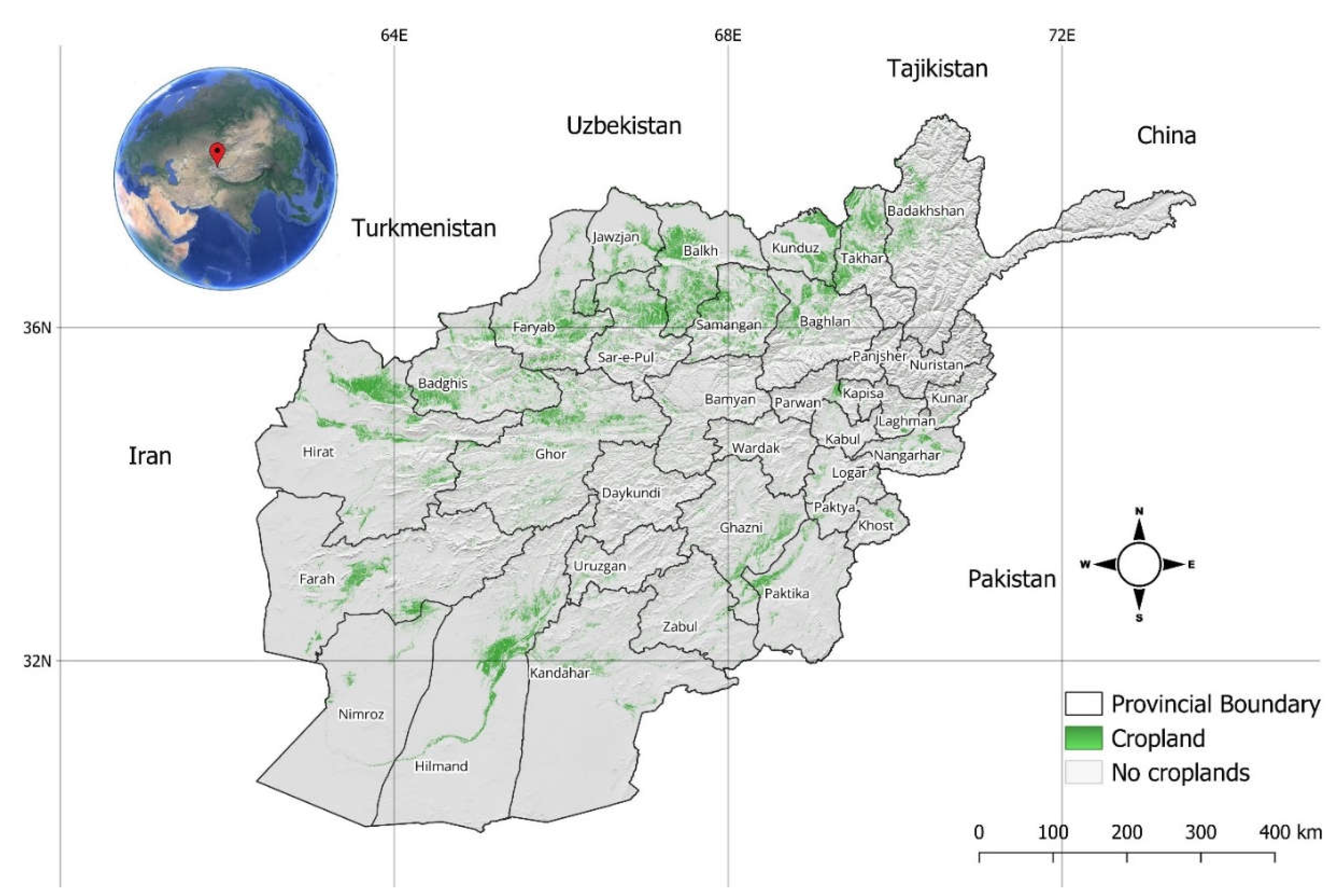
Figure 2.
IPCC 2014 Framework.
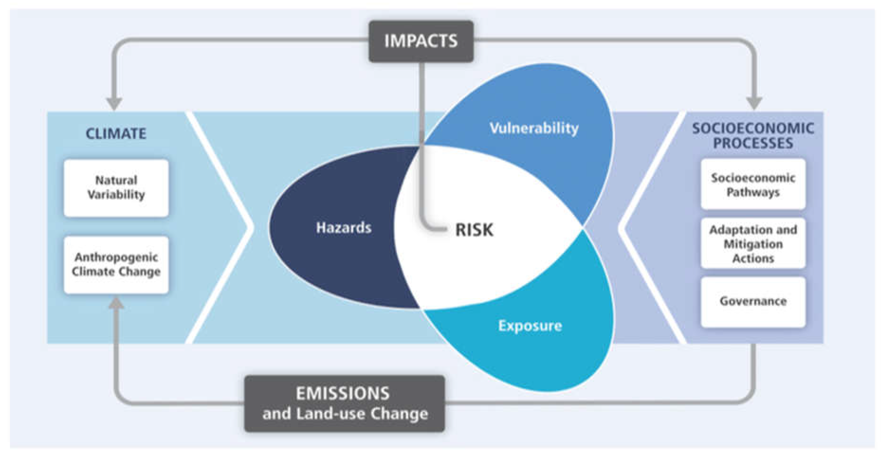
Figure 3.
Illustrates the research workflow, adapted from Hagenlocher & Castro (2015).
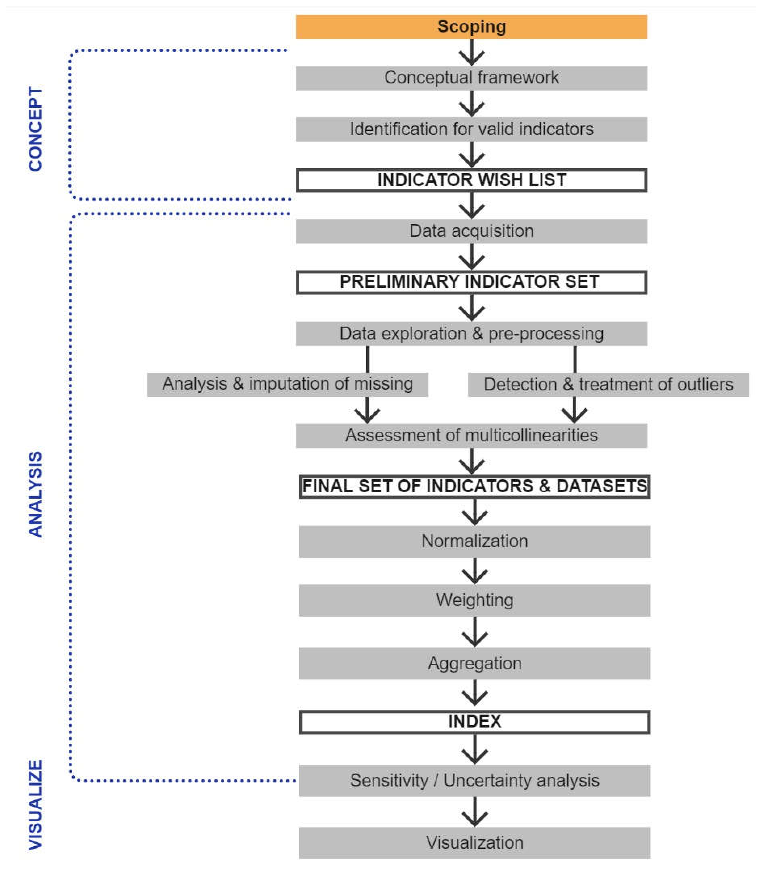
Figure 4.
Seasonal vegetation Condition index (VCI) composites (2001–2023).
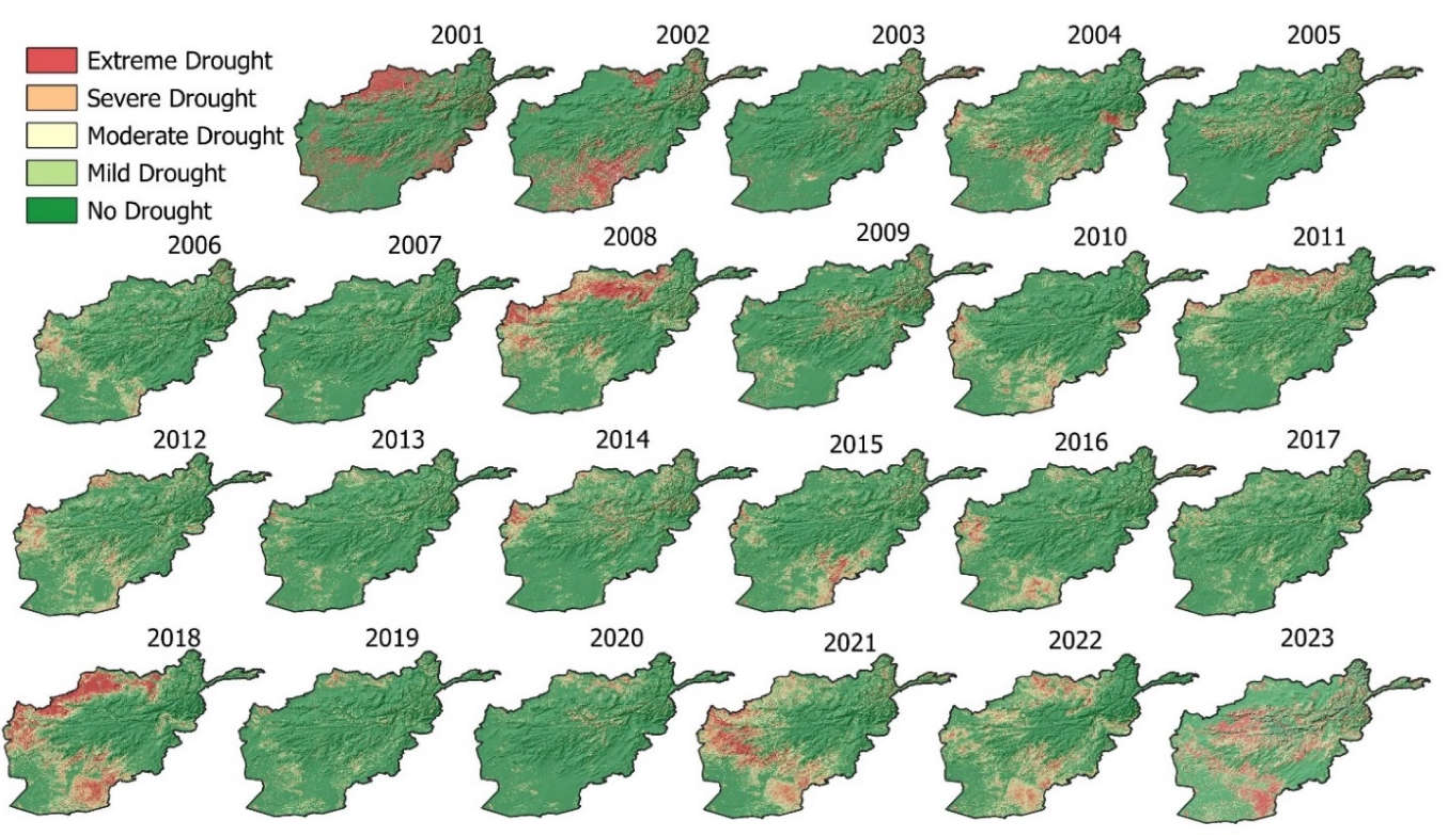
Figure 6.
Cropland exposure to drought Hazard in Afghanistan.
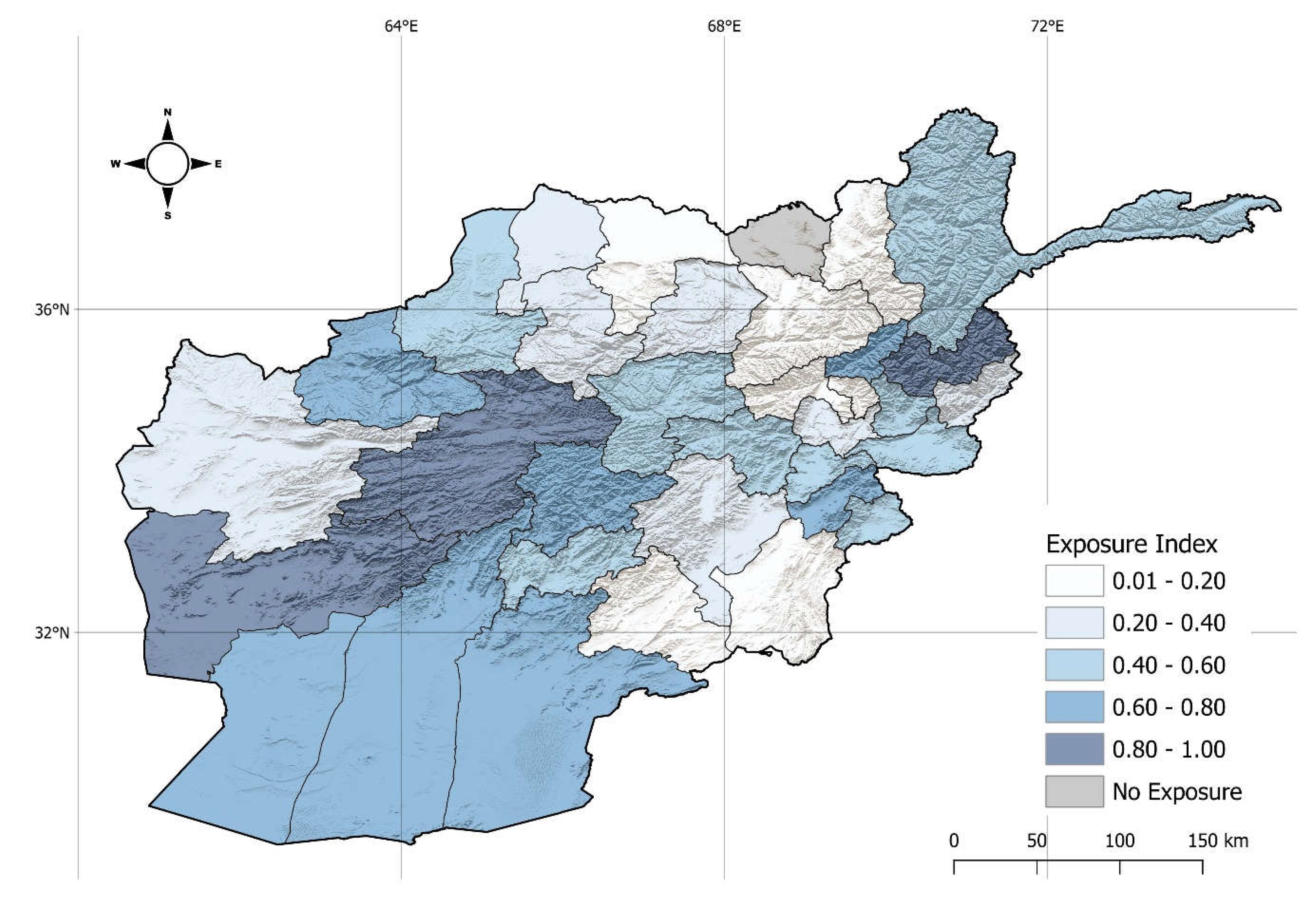
Figure 7.
Drought vulnerability in Afghanistan.
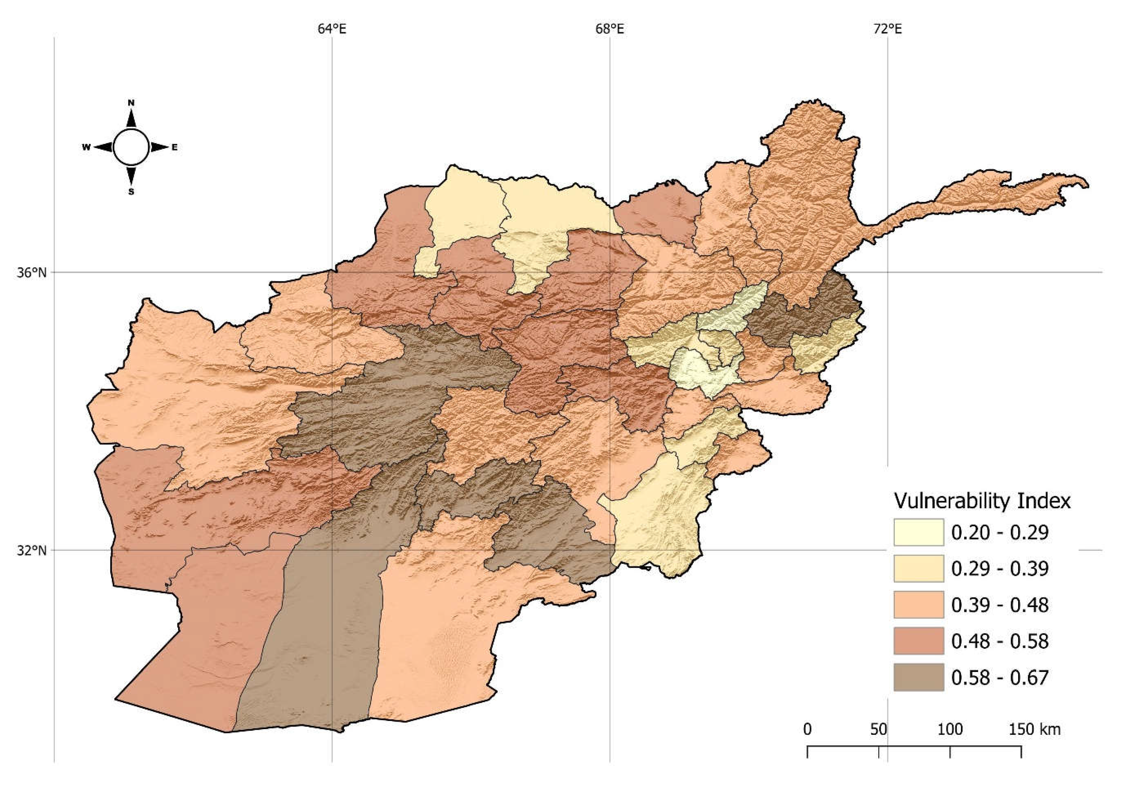
Figure 8.
Drought risk to agriculture system in Afghanistan.
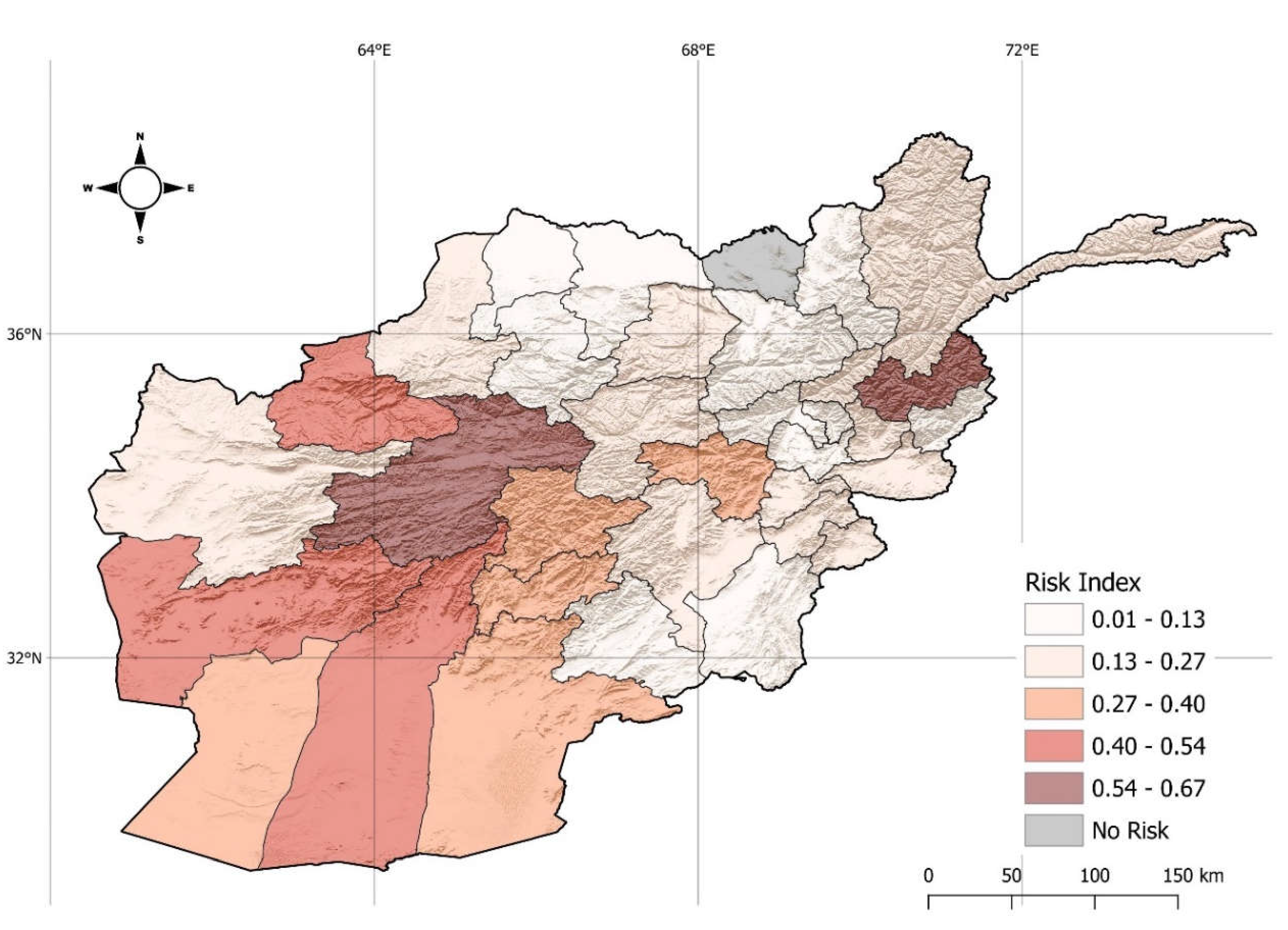
Figure 9.
Drought risk plotted against exposure and people engage in agriculture.
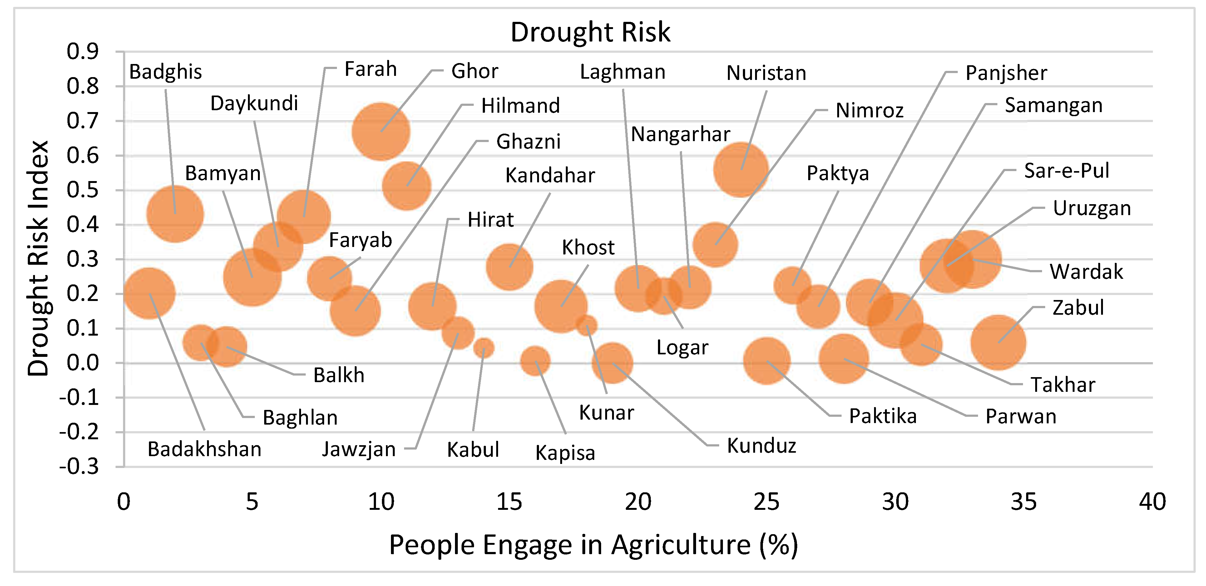

Table 1.
Drought vulnerability indicators with data sources.
| Code | Indicator | Data Source | Direction |
|---|---|---|---|
| Susceptibility | |||
| S_IAL | Income: Agriculture & Livestock | WB, ALCS 2016-17 | + |
| S_EA | Employment in Agriculture | WB, ALCS 2016-17 | + |
| S_SPL | Sufficient Pasture Land | WB, ALCS 2016-17 | + |
| S_GI | Gini Index | WB, ALCS 2016-17 | + |
| S_PR | Illiteracy Rate | WB, ALCS 2016-17 | + |
| S_DR | Dependency Ratio | WB, ALCS 2016-17 | + |
| S_IR | Poverty Rate | WB, ALCS 2016-17 | + |
| S_SDW | Safe Drinking Water | WB, ALCS 2016-17 | + |
| S_IDPs | Internal Displaced People (IDPs) | IOM DTM 2016 | + |
| S_FS | Food Security | WB, ALCS 2016-17 | + |
| Lack of Coping Capacity | |||
| C_SLA | Ownership of Livestock | WB, ALCS 2016-17 | - |
| C_OL | Sold Live Animals | WB, ALCS 2016-17 | - |
| C_PRPT | Primary Road Per Thousand Inhabitants | WB, Open Street map 2018 and NSIA 2017 | - |
| C_ATI | Access to information | NSIA 2018-19 | - |
Disclaimer/Publisher’s Note: The statements, opinions and data contained in all publications are solely those of the individual author(s) and contributor(s) and not of MDPI and/or the editor(s). MDPI and/or the editor(s) disclaim responsibility for any injury to people or property resulting from any ideas, methods, instructions or products referred to in the content. |
© 2024 by the authors. Licensee MDPI, Basel, Switzerland. This article is an open access article distributed under the terms and conditions of the Creative Commons Attribution (CC BY) license (http://creativecommons.org/licenses/by/4.0/).
Copyright: This open access article is published under a Creative Commons CC BY 4.0 license, which permit the free download, distribution, and reuse, provided that the author and preprint are cited in any reuse.


