
Submitted:
21 July 2024
Posted:
22 July 2024
You are already at the latest version
Abstract
The effective utilization of medium-high temperature geothermal energy is pivotal in reducing carbon emissions and plays a crucial role in developing clean energy technologies. The MiDu ge-othermal field, situated in the southeastern region of Dali Prefecture, Yunnan Province, lies within the Mediterranean-Himalayan high-temperature geothermal belt and is characterized by abundant geothermal resources. However, due to its considerable depth, exploration poses significant risks, resulting in a total utilization rate of less than 0.5% of the total reserves. This study employs natural seismic data to perform a tomographic analysis of the geothermal system in the Midu basin. By examining the P-wave velocity (Vp) and velocity ratio of P-wave and S-wave (Vp/Vs) at various depths, the findings reveal that the basin comprises two distinct structural layers: the thrust basement of the Mesozoic and Paleozoic eras and the strike-slip extensional sedimentary layer of the Cenozoic era. A low-velocity anomaly in the central basin corresponds to the loose Cenozoic sedimentary layer. In contrast, high-velocity anomalies at the basin edges correlate with boundary faults and the Mesozoic-Paleozoic strata. Below a depth of 4 km, the Red River Fault and MiDu Fault continue to dominate the basin's structure, whereas the influence of the Malipo Fault dimin-ishes. The MiDu Fault exhibits higher thermal conductivity than the Yinjie Fault. It interfaces with multiple carbonate and basalt formations characterized by well-developed pores and fractures, making it a crucial conduit for water and a control point for geothermal storage. Consequently, the existence of high temperature geothermal resources for power generation should be concentrated around the Midu fault on the western side of the basin, while the Yinjie fault area is more favorable for advancements in heating and wellness.
Keywords:
geothermal resources
; seismic tomography imaging
; velocity ratio
; Midu basin
; genesis mechanism
1. Introduction
In recent years, geothermal resources have been referred to as geothermal energy, geothermal fluids, and their valuable components that humans can use economically [1]. They are characterized by cleanliness, renewability, large resource volume, and strong stability. Based on temperature, they can be divided into low-temperature geothermal resources (<90°C), medium-temperature geothermal resources (90-150°C), and high-temperature geothermal resources (≥150°C) (Terminology of Geothermal Energy, 2018). China's mainly hydrothermal middle-to-low temperature geothermal resources are equivalent to 1.25 trillion tons of standard coal; each year, there is an extractable amount equivalent to 1.865 billion tons of standard coal. China’s geothermal resources account for one-sixth of global resources with enormous development potential. Using underground hot water resources efficiently could save up to 750 million tons of coal equivalents annually, reduce greenhouse gas emissions, and improve the ecological environment[2]. However, in the future development of clean energy sources, geothermal energy must occupy a significant place while the application for generating electricity from high-temperature geothermal sources is essential. Firstly, geothermal power generation is zero-emission and pollution-free, which can effectively reduce environmental impact. Second, heating, wellness, and other Cascade utilization applications are more viable near the Yinjie Fault. The exceptionally high stability provides a continuously available power supply with more than 8000 operating hours per year, five eight times higher annual utilization rates than that provided by solar or wind power. The distribution of geothermal resources is significantly controlled by tectonics. Globally, there are four major high-temperature geothermal belts: the Circum-Pacific Geothermal Belt, the Mid-Atlantic Ridge Geothermal Belt, the Red Sea–Aden Gulf–East African Rift Geothermal Belt, and the Mediterranean–Himalayan Geothermal Belt. The Midu geothermal field is located in southeastern Dali, Yunnan Province (Figure 1a), and tectonically belongs to the Mediterranean-Himalayan high-temperature geothermal belt. It possesses abundant geothermal resources, with a high terrestrial heat flow value of 75 mW/m², above China's national average, indicating good prospects for geothermal energy development[3]. However, the overall utilization rate is less than 0.5%. Besides this factor, deep burial depth exceeding 2000 meters poses significant risks[4]. Detailed geological exploration and evaluation are essential when developing and utilizing geothermal resources in the Midu area. Previous studies have discussed and analyzed the characteristics and formation patterns of typical hot springs in this region [5,6]. However, research on subsurface geological structures, groundwater bodies, and the migration of geothermal fluids remains insufficient. This gap hinders a comprehensive description of the geothermal reservoir's characteristics, including its location, depth, capacity, temperature, and additional heat sources. Therefore, it is crucial to employ economical and effective geophysical methods to investigate the deep structure of the basin and the geothermal system.
Seismic tomography imaging technology detects underground structures, revealing changes in subsurface structures by analyzing the propagation of seismic waves underground. Passive seismic tomography imaging technology has been proven effective in applications such as imaging volcanic structures [7,8,9,10,11], geothermal fields [12], geothermal springs [13], and faults [14]. By recording and analyzing seismic waves, velocity models of underground media can be obtained, enabling inference of characteristics such as the position, thickness, and temperature of thermal reservoirs. Additionally, seismic tomography imaging can reveal channels and pathways for the movement of thermal fluids within geothermal systems, guiding the development of hydrothermal resources. Local seismic tomography imaging[15] focuses on inverting local seismic propagation to address joint problems of seismic source location and velocity model determination. It has been applied to characterize intrusive body distribution, fluid pathways, and accumulation zones within active volcanic systems[10,16,17,18]. Researchers typically deploy seismic arrays and collect seismic data for local seismic tomography imaging studies. By analyzing the propagation and reflection paths of seismic waves in conjunction with the velocity information of subsurface media, three-dimensional models of underground structures can be established in study areas. The velocities of compressional waves (Vp), shear waves (Vs), and the ratio of Vp/Vs vary with fluid composition, rock porosity, and temperature changes. By comparing Vp and Vp/Vs, the distribution patterns of thermal reservoirs and thermal conductivity structures underground can be determined. Therefore, local tomographic imaging methods can be used to image the structure of underground geothermal systems in regions with active local seismicity. As a crucial adjustment zone for crustal material escape and deformation on the southeastern margin of the Qinghai-Tibet Plateau, conducting seismic tomography imaging studies in the Midu basin is of significant importance for understanding the characteristics of neotectonic movements, the genesis mechanism of geothermal systems, and their inherent connections with the Mediterranean-Himalayan high-temperature geothermal belt in western Yunnan Province.
2. Geological Setting
The Midu basin is located at the southeast margin of Dali Bai Autonomous Prefecture, Yunnan Province, China (Figure 1a–c), at the northwest end of the Red River Fault Zone (F1). It is a significant extensional deformation zone between a series of sizeable arcuate strike-slip fault systems at the southeastern margin of the Qinghai-Tibet Plateau. The basin is characterized by the development of numerous Neogene extensional rift basins, making it a key area for revealing the formation mechanism of the northwest Yunnan rift zone[19,20], and it is also one of the most seismically active regions in China. The basin is 26 km wide east-west, 82 km long north-south, covering an area of approximately 1523 km² (Figure 2). It is controlled by the Yinjie Fault (F3), a right-lateral strike-slip fault trending NW-SE, the Maolipo Fault (F4), a left-lateral strike-slip fault trending NNE-SSW, and the Midu Fault (F2), which collectively form a blunt-angled triangular shape trending northwestward. The boundary faults on the southwest and northeast sides of the basin exhibit typical fault characteristics. The left-lateral Maolipo Fault marks the boundary on the northwest side, while the Yinjie Fault constitutes the boundary on the southeast side, both converging with the Red River Fault (F1) in the southern part of the basin. The structural style of the Midu Basin is similar to that of the Xiangyun Basin to its east (Figure 2a), with a Miocene-present Xiangyun nappe structure between them. Paleozoic strata have been thrust northeastward over Mesozoic strata, forming several north-eastward imbricate thrust faults[6]. Since the late Eocene, the study area has been dominated by extensional fault activity, accompanied by significant clockwise rotation, which has disrupted the Upper Eocene sedimentary strata while controlling Quaternary alluvial deposits.
The basement of the Midu area is composed of Proterozoic metamorphic complex. The cover mainly includes Devonian to Permian shallow marine limestones, mudstones, and siliceous rocks, with a thickness of 3481 meters for the Devonian and 6875 meters for the Permian. The Triassic to Cretaceous shallow marine limestones and terrestrial conglomerates is rich in water-bearing fractures, with a thickness of 4785 meters for the Triassic and more than 2169 meters for the Cretaceous. In the Cenozoic, there are bottom sandstone deposits with strong water-bearing properties, overlying volcaniclastic rock with a thickness greater than 1884 meters, and the Quaternary is predominantly conglomeratic sandstone with medium to water-bearing solid properties and a thickness ranging from 86 to 238 meters. Cambrian, Ordovician, and Silurian systems were not observed. Demarcated by the Midu basin, the eastern side is dominated by Paleozoic marine carbonate deposits and purple-red tuffaceous rocks, andesitic porphyrites, as well as pebble-like basalts from eruption deposits. In contrast, the western side mainly consists of Mesozoic sandstones and coal-bearing fluvio-lacustrine deposits. Within the basin, there are predominantly Neogene and Quaternary alluvial deposits. The basin extends in a narrow NW-SE direction, with terrain in the northeast higher than the southwest. There are five typical natural hot springs within the basin. The geothermal water, stored in the Cenozoic basin, has surface temperatures ranging from 40 to 72.5°C. The reservoir temperature, calculated by SiO2 geothermometers, ranges from 93.5 to 116.9°C, with depths ranging from 2537 to 3374 meters. Due to the inception of basin water systems, the thickness of loosely porous Cenozoic formations generally ranges from hundreds to thousands of meters, with relatively high cold water mixing in the hot springs, suggesting the presence of deep high-temperature springs.
Based on the development conditions of the basin and surrounding areas, it is inferred that there should be thick layers of Paleozoic and Mesozoic strata beneath the Cenozoic strata. Among them, the loose Cenozoic sedimentary layers and easily eroded carbonate rocks and porous basalt of the Paleozoic are favorable areas for developing geothermal reservoirs in the region. Previous studies suggest that the Jinsha River-Red River fault has reached the depth of the Moho discontinuity[22], and the Midu basin belongs to a deep fault-circulation geothermal system[6]. Theoretically, heat sources include mantle-derived heat, magmatic heat within the crust, and radiogenic heat from intrusive rocks in the crust, with surface-measured geothermal flux values reflecting the combined effects of these three heats. The proportion of these three heats varies in different regions. In Midu, the heat contribution from the mantle and radiogenic heat from radioactive elements in the crust dominate, with granite outcrops along the Midu fault indicating evidence of large-scale intrusive bodies in the basin's depths. The Curie depth in Midu is approximately 24 km[23], with an average Moho depth of 45 km[24,25], and the average Moho temperature is referenced around 1068-1122°C[26]. The geothermal gradient is slightly higher than normal, generally 25-30°C/km[6]. The heat production rate of Midu's medium-acidic rock ranges from 1.62 to 2.83 μW/m³, with a geothermal gradient of 2.5-5°C/100m. In sedimentary rock areas, the geothermal gradient is around 2.5°C/100m, roughly equivalent to the average geothermal gradient above the Curie depth of 2.42°C/100m; in areas where medium-acidic rocks with concentrated radioactive elements exist, the geothermal gradient can reach 5°C/100m(Wang Ji’an et al., 1990).
3. Data Acquisition and Processing
3.1. Date Acquisition
The study used the smarsolo-IGU-BD3C-5 three-component seismometer with approximately 2-3 km station spacing. A total of 87 stations were deployed (with 2 stations losing data), covering an area of about 28×28 km, which essentially spans the entire Midu basin (Figure 3). Data was sampled at 4 ms intervals and continuously monitored for one month, during which 294 local earthquakes were observed (Figure 4a). Through high signal-to-noise ratio waveform phase picking, 10,713 initial P-wave phases and 6,022 initial S-wave phases were obtained (Figure 4b), showing a dense distribution throughout the study area, conducive to reliable tomographic imaging results.
3.2. Date Processing
In this study, An initial Vp/Vs value of 1.75 is estimated by minimizing the RMS of S-wave arrival times, as shown in Figure 5a. This method utilizes the time difference between different seismic events at various stations for statistical analysis, with the formula as follows:
where 、、、、, and represent the time differences of P-waves and S-waves, the arrival times of P-waves and S-waves, the velocities of P-waves and S-waves, respectively, between different stations (i and j) for the same event. and are the epicentral distances corresponding to the different stations (i and j) for the event.
Considering the limited previous research in this region and extensive seismic tomography experiments on crustal velocity structures conducted close to this area in Binchuan, we drew upon the research of predecessors[27,28]. We utilized a one-dimensional initial P-wave velocity model from the Binchuan region (Figure 5b) and adopted an initial Vp/Vs ratio of 1.75 for local earthquake 3D tomographic inversion. The inversion employed the simul2000 program[29,30,31,32], which is widely applied in small-scale imaging. Since S-wave arrivals are generally fewer and less reliably picked than P-wave arrivals, simul2000 utilizes P-wave and S-P time differences to invert for Vp and Vp/Vs, which is more stable and reliable than direct Vs inversion[32]. Additionally, Vp/Vs is directly related to Poisson's ratio and better reflects physical properties than Vs alone. In sedimentary basins, saturation of sediments, high porosity, and low compactness lead to reduced P-wave velocities. These sediment characteristics influence S-wave propagation more, resulting in more pronounced decreases in S-wave velocity, hence showing anomalously high Vp/Vs ratios. This integrated effect reflects the physical and fluid properties of basin sediments. The structural type in the study area belongs to a typical faulted basin, characterized by low Vp and high Vp/Vs ratios. Through comparison of these two parameters, the basin extent and aquifer structures can be identified, dissecting the spatial configuration of the Midu Basin geothermal system.
A grid size of 5km × 5km was set laterally, and depths were defined at 0 km, 3 km, 6 km, and 9 km in the inversion process. We balanced the choice of damping parameters by analyzing the trade-off between data misfit and model variance[33,34,35]. The optimal damping parameters were selected by searching over a wide range of damping values (10 to 9000), as shown in Figure 6a,b. Initially, the damping coefficient for Vp/Vs was set to 9000 to minimize the influence of S-wave velocity according to the distribution of the L-curve for Vp damping set at 90 (Figure 6a). Then, with Vp damping fixed at 90, the damping for Vp/Vs was selected and set to 60 (Figure 6b). It can be observed that the inversion converged after 13 iterations. Before inversion, residual distribution ranged from -1.5 to 0s, indicating an overall bias between the initial and true velocity models. After inversion, both P-wave and S-wave travel time residuals centered around 0s and exhibited Gaussian distributions (Figure 6c,d).
We used the checkerboard testing method to evaluate the quality of the inverted model. Based on the initial one-dimensional model, perturbations of for Vp and for Vp/Vs were applied to adjacent grids. The evaluation revealed that all inverted parameters matched those obtained from actual data inversion. The results of the checkerboard testing are shown in Figure 7 (where 1.0 represents the best resolution, 0 indicates no resolution, and the blue contour lines envelope areas with a resolution greater than 0.1). From 0 km to 3 km depth, both Vp and Vp/Vs exhibit good resolution in the study area. Beyond 3 km depth, the imaging resolution in the study area deteriorates. Below 6 km depth, anomalies are observed only in the northern part of the dense array.
4. Result and Geological Interpretation
According to the inversion results, the distribution of P-wave velocity (Vp) and velocity ratio (Vp/Vs) at different depths in the study area is shown in Figure 8. The basin can be divided into two structural layers: the Mesozoic overthrust basement and the Cenozoic strike-slip and extensional sedimentary layer. The Mesozoic overthrust basement formed during the compression period of the Indian Plate, while the Cenozoic sedimentary layer mainly formed during the escape period of the western Yunnan Plate. From the Vp and Vp/Vs distribution, the velocity structure beneath the Midu basin shows certain lateral zoning rules and significant vertical inheritance. The central part of the basin exhibits a low-velocity anomaly in Vp, while the margins show high-velocity anomalies. The distribution of anomalous belts is related to fault structures, with the Honghe and Midu faults marking the eastern and western boundaries, respectively, and the Malipo fault controlling the northern part. At depths greater than 3 km, Vp generally continues to exhibit a northwestward trend, indicating that the Honghe and Midu faults remain the primary controlling faults of the basin. However, the influence of the Malipo fault on the basin is largely diminished, suggesting that its cutting depth is relatively shallow. The significant westward shift of the Vp low anomaly indicates that the main Midu fault extends westward at depth. Moreover, the thickness of Cenozoic porous formations in the Midu basin is less than 3 km, extending downward into the Mesozoic basement. At a depth of 6 km, the Vp anomaly section shows good vertical inheritance, with persistent high-value anomalies east of the Honghe fault, suggesting favorable targets for deep geothermal resources such as basalt or Carboniferous-Permian porous formations, similar to those east of the Yinjie fault. Effective imaging becomes challenging beyond a depth of 6 km.
The Vp/Vs anomaly features, on the contrary, show a high-speed northwest-oriented band from 0 to 3 km, sandwiched by middle to low-speed zones. The boundary of the high-speed band coincides with the location of the controlling basin faults, which is consistent with Vp observations. Below 3 km, there is a significant change in the slice characteristics of both Vp/Vs parameters, but the overall pattern still forms a northwest-oriented band. As the basin enters the Mesozoic basement, the aquifer properties decrease. The liquid responses east of the Red River fault and the Midu fault zone become more pronounced. At a depth of 6 km, there is a significant change in the distribution of Vp/Vs anomalies on the slice, with a distinctive inverted "T" anomaly appearing in the central part of the study area. The anomaly shows less response between faults, indicating attenuation and extinction of the Midu fault at this depth (Figure 8).
By using velocity inversion, the epicenter can be repositioned. The distribution of earthquake locations before and after velocity structure inversion is shown in Figure 10. In the figure, black triangles represent the effective stations used, while red dots represent the relocated results of local earthquake inversions retrieved from the Midu earthquake data catalog. Compared to before relocation (Figure 4a), the seismic distribution after relocation is more reasonable, with a closer relationship to the fault. The depth positioning of the epicenter is more consistent with the characteristics of natural earthquakes (Figure 4b). The accuracy of tomographic imaging also improves after relocation.
According to the longitudinal section of the tomographic imaging (Figure 9, the Vp inversion profile shows low values shallower than 2 km, with low-value areas extending beyond 3 km in the Midu basin region. Below the basin, at depths exceeding 4 km, high-value anomalies appear, notably higher than both the eastern and western sides. It is inferred that there exists a magmatic intrusion body at the bottom of the basin, distinct from the Mesozoic basement, although the reflection of boundary faults is rather indistinct. The Vp/Vs inversion profile provides a more precise characterization of the basin and boundary faults. Regions with Vp/Vs values >1.85 generally correspond to the development range of Cenozoic basins, while blocks with values <1.6 correspond to rigid intrusive bodies such as granite, divided into eastern and western parts by the Midu fault, with the western part being more significant and uplifted. Values between 1.6 and 1.85 correspond to the basement from Mesozoic to Paleozoic.
5. Discussion
Through relocation findings, it is discovered that the boundary faults of the Midu basin do not constrain the seismogenic faults. Earthquakes are mainly distributed in the northern part of the basin, providing relatively stable seismic sources for fine tomographic imaging in the study area. With the finer 3-D seismic velocity model, we resolve the subsurface structure beneath the Midu basin. The velocity of seismic waves is influenced by lithology, structure, pore pressure, and fluid saturation. By analyzing and comparing Vp and Vp/Vs slices, the spatial configuration relationships between the deep structure, thermal reservoirs, and thermal-conductive structures of the Midu basin can be inferred and characterized.
5.1. Faults System
Based on the distribution of seismogenic faults, the Yinjie Fault and the Midu Fault have exhibited relative stability with minimal activity since the Quaternary period. The Vp/Vs profile distinctly delineates the extent of the Cenozoic basin and its basement, with the Midu Fault displaying distinct segmentation. At depths, shallower than 2 km, the fault is characterized by low Vp and high Vp/Vs. ratios, with the high Vp/Vs. boundary demarcating the edge of the Cenozoic basin. This boundary corresponds to an east-dipping normal fault converging with the Red River Fault. Tectonic reconstruction indicates that the Midu Fault, as part of the Red River Fault, was subjected to left-lateral shear from the Maolipo Fault during its right-lateral strike-slip movement, forming a strike-slip basin with a Paleo-Mesozoic basement, upon which the Cenozoic sediments were deposited.
At depths greater than 4km, high Vp and low Vp/Vs characteristics indicate a substantial acidic intrusive body. This velocity characteristic is divided into two segments, indicating a deep-seated fault, likely representing the deep extension of the Midu Fault. However, its orientation is opposite to that of the Cenozoic layer, and it formed concurrently with the Xiangyun Thrust as a west-dipping compressional-shear fault.
The seismic characteristics in the vicinity of the Yinjie Fault on the eastern side of the basin are consistent with those of the Midu Fault, indicating the presence of deep compressional-shear faults. Following the Pliocene epoch, extensional tectonics within the Midu basin induced structural inversion of these faults, transforming them into normal faults. Despite this inversion, their activity levels remain low. Together with the Midu Fault, the Yinjie Fault exerts control over the structural framework of the Cenozoic basin.
5.2. Geothermal System
The geothermal system comprises a heat source, heat reservoir, conductive structures, and water-controlling structures. Tomographic imaging reveals that both Vp and Vp/Vs ratios respond significantly to deep-seated faults. However, Vp/Vs more clearly delineates porous media and basin boundaries. While the Cenozoic basin and the Cretaceous to Triassic sediments are predominantly composed of sandstone and mudstone, differential compaction results in significant variations in Vp/Vs ratios.
At depths shallower than 2 km, low Vp and high Vp/Vs characteristics indicate a high porosity and water content in the Cenozoic formations, making this layer one of the primary heat reservoirs in the basin. In the 2-4 km depth range, seismic velocity features are less pronounced, but geological analyses suggest that the widely developed basalt and limestone in this interval represent potential heat reservoirs. The circulation depths of the hot springs exposed within the basin are all shallower than 4 km (Table 1), corresponding to this thermal reservoir. At depths greater than 4 km, acidic intrusive rocks act as favorable radiogenic heat sources. Deep-seated faults cutting through these intrusive rocks serve as convective pathways for deep heat sources, and are crucial conductive faults in the study area. However, due to the segmentation of the Midu Fault, the thermal energy conducted through these fault channels does not directly surface, but instead migrates to the base of the Cenozoic basin. This heat is then exposed near NE or nearly E-W trending faults, such as the Maolipo Fault, that intersect the Cenozoic formations.
Among the deep faults, the Midu Fault exhibits a higher thermal conductivity capacity compared to the Yinjie Fault. This is primarily because the western side of the basin directly interfaces with heat-generating granitic rocks, while the eastern Yinjie Fault intersects multiple carbonate and basalt formations with well-developed pores and fractures, functioning as a major water-conducting and storage-controlling fault.
Therefore, high-temperature geothermal resources suitable for power generation should be sought near the Midu Fault on the basin's western side. In contrast, applications such as heating and wellness resorts are more feasible near the Yinjie Fault due to its water-conducting properties (Figure 10).
6. Conclusions
Through data analysis and epicenter relocation, it is confirmed that the boundary faults of the Midu basin do not strictly control the seismic faults. Currently, seismic activity is not strong, with earthquakes mainly distributed in the northern part of the basin. The active faults include the northeast-trending Maosupo Fault, which is more active than the northwest-trending Midu Fault, and the Yinjie Fault. These faults provide a relatively stable seismic source for tomographic imaging in the study area.
Both Vp and Vp/Vs reflect the velocity stratification of different geological units and layers in the Midu basin. They respond significantly to the major faults at depth, with Vp/Vs delineating porous media and basin boundaries more clearly. The sedimentary rocks from the Neogene basin to the Cretaceous to the Triassic are primarily sandstone and mudstone, but their velocity ratios vary significantly due to different compaction effects. The Neogene basin, with higher porosity and water content, serves as the main thermal reservoir in the basin. Large-scale mildly acidic rock bodies at the bottom and western part of the basin constitute potential heat sources, while extensive basalt and limestone in the eastern basin basement serve as potential thermal reservoirs.
The development of the Midu Fault is segmented. The current fault, known as the controlling basin fault, primarily controls the sedimentation range of the Neogene basin and serves as the main conduit and storage structure for water. Below the Neogene, early-formed west-dipping reverse faults exist, with the Midu Fault cutting through the acidic rock bodies at the basin bottom during this stage. This fault serves as the main thermal control structure in the basin, providing deep thermal sources.
Seismic tomography indicates effective spatial relationships among heat sources, thermal control structures, water-conducting structures, and thermal reservoirs in the geothermal system of the Midu basin. These relationships correlate with the segmented nature of the Midu Fault. The geothermal system of the basin can be divided into two layers: a medium-low-temperature geothermal system in the Neogene porous media and a medium-high-temperature geothermal system in the Paleogene-Mesozoic basin underlying the Neogene basin. The western side of the Midu basin is a favorable target for exploring medium-high-temperature geothermal resources.
Author Contributions
Conceptualization, Jie Li, Chao Xu and Chuan Li; methodology, Chao Xu and Chuan Li; software, Chao Xu, Chuan Li, Ziye Yu and Yunpeng Zhang; validation, Jie Li and Chao Xu Zhao; formal analysis, Chao Xu; investigation, Chuan Li and Hui Tan; resources, Hui Tan and Xuebin Zhang; data curation, Chao Xu and Chuan Li; writing—original draft preparation, Chao Xu and Jie Li; writing—review and editing, Jie Li, Chao Xu , Chuan Li, Xuebin Zhang and Hui Tan; visualization, Chao Xu and Zhengguang Zhao; supervision, Ruizhao Yang and Le He; project administration, Chao Xu, Chuan Li, Jie Li and Xuebin Zhang ; funding acquisition, Jie Li and Hui Tan; All authors have read and agreed to the published version of the manuscript.
Funding
We gratefully acknowledge the Research funds of The Guangxi Key Laboratory of Theory and Technology for Environmental Pollution Control (GKN2201K004), the Key Research and Development Program in Yunnan Province, “Research on Key Technologies for Exploration and Development of Deep and Medium Geothermal Energy in Yunnan Province (No.202302AF080001) “Mineralization laws and Prospecting Technology Research in the Key Mining Cluster Area of Western Yunnan Province (NO. 202303AA080006)”, Shenzhen Municipal Science and Technology Innovation Committee(JCYJ20220818103010021) to this research.
Data Availability Statement
Not applicable
Acknowledgments
We would like to thank the Institute of Urban Underground Space and Energy Studies, The Chinese University of Hong Kong, Shenzhen, for providing the microseismic datasets used in this research.
Conflicts of Interest
The authors declare no conflicts of interest.
References
- Huanquan, S.; Xiang, M.; Chenbingjie, W.; Dianbin, G.; Haitao, W.; Shaochuan, S.; ZHANGYing; Lu, L. , Geothermal resources exploration and development technology:Current status and development directions. Earth Science Frontiers 2024, 31, 400–411. [Google Scholar]
- Guiling, W.; Wei, Z.; Jiyun, L.; Wenjing, L.; Zhiming, L.; Wanli, W. , Evaluation of Geothermal Resources Potential in China. Acta Geoscientica Sinica 2017, 38, 449–450+134+451-459. [Google Scholar]
- Zhang, L.; Chen, S.; Zhang, C. , Geothermal power generation in China: Status and prospects. Energy Science & Engineering 2019, 7, 1428–1450. [Google Scholar]
- Ozdemir, A.; Arabaci, F.; Palabiyik, Y. , Reevaluation of geothermal potential of Çubukludağ Graben (Western Anatolia, Turkey). International Journal of Earth Sciences Knowledge and Applications 2021, 3, 70–88. [Google Scholar]
- Dongxue, H. A study of the hydrochemical cahracteristics and geneses of the hot springs in the Midu - Xiangyun area of Yunnan Province. Master, 2019.
- Yongzhong, Y. Analysis of geological characteristics and genetic model of Midu hot spring. Master, 2010.
- Brenguier, F.; Shapiro, N.M.; Campillo, M.; Nercessian, A.; Ferrazzini, V. , 3-D surface wave tomography of the Piton de la Fournaise volcano using seismic noise correlations. Geophysical research letters 2007, 34. [Google Scholar] [CrossRef]
- Masterlark, T.; Haney, M.; Dickinson, H.; Fournier, T.; Searcy, C. Rheologic and structural controls on the deformation of Okmok volcano, Alaska: FEMs, InSAR, and ambient noise tomography. Journal of Geophysical Research: Solid Earth 2010, 115. [Google Scholar] [CrossRef]
- Stankiewicz, J.; Ryberg, T.; Haberland, C.; Fauzi; Natawidjaja, D. Lake Toba volcano magma chamber imaged by ambient seismic noise tomography. Geophysical Research Letters 2010, 37. [Google Scholar] [CrossRef]
- Koulakov, I.; Shapiro, N. , Seismic tomography of volcanoes. Encyclopedia of earthquake engineering 2015, 15, 1–18. [Google Scholar]
- Cabrera-Pérez, I.; Centeno, R.; Soubestre, J.; D'Auria, L.; Rivera, M.; Machacca, R. , Ambient noise tomography of Misti volcano, Peru. Journal of Volcanology and Geothermal Research 2022, 426, 107538. [Google Scholar] [CrossRef]
- Yang, Y.; Ritzwoller, M.H.; Jones, C.H. Crustal structure determined from ambient noise tomography near the magmatic centers of the Coso region, southeastern California. Geochemistry, Geophysics, Geosystems 2011, 12. [Google Scholar] [CrossRef]
- Nayak, A.; Taira, T. a.; Dreger, D.S.; Gritto, R. , Empirical Green's tensor retrieved from ambient noise cross-correlations at The Geysers geothermal field, Northern California. Geophysical Journal International 2018, 213, 340–369. [Google Scholar] [CrossRef]
- Mordret, A.; Roux, P.; Boué, P.; Ben-Zion, Y. , Shallow three-dimensional structure of the San Jacinto fault zone revealed from ambient noise imaging with a dense seismic array. Geophysical Journal International 2019, 216, 896–905. [Google Scholar] [CrossRef]
- Kissling, E. , Geotomography with local earthquake data. Reviews of Geophysics 1988, 26, 659–698. [Google Scholar] [CrossRef]
- Jousset, P.; Haberland, C.; Bauer, K.; Arnason, K. , Hengill geothermal volcanic complex (Iceland) characterized by integrated geophysical observations. Geothermics 2011, 40, 1–24. [Google Scholar] [CrossRef]
- Muksin, U.; Bauer, K.; Haberland, C. , Seismic Vp and Vp/Vs structure of the geothermal area around Tarutung (North Sumatra, Indonesia) derived from local earthquake tomography. Journal of volcanology and geothermal research 2013, 260, 27–42. [Google Scholar] [CrossRef]
- Zhang, Q.; Lin, G. , Three-dimensional Vp and Vp/Vs models in the Coso geothermal area, California: Seismic characterization of the magmatic system. Journal of Geophysical Research: Solid Earth 2014, 119, 4907–4922. [Google Scholar] [CrossRef]
- Xiaolong, H.; Zhonghai, W.; Kungang, W. , Late Cenozoic development characteristics and dynamic mechanism of the main faults in the Midu area,northwestern Yunnan. Journal of Geomechanics 2021, 27, 913–927. [Google Scholar]
- Xiaolong, H.; Zhonghai, W.; Kungang, W.; Chunjing, Z. , THE MAIN ACTIVE FAULTS AND TECTONIC SYSTEM IN YONGSHENG AREA,NORTHWESTERN YUNNAN. Journal of Geomechanics 2016, 22, 531–547. [Google Scholar]
- Yun, W.; Hua, R.; Qilin, L.; Ciping, Z.; Lishuang, G.; Yaowei, L. , A Study on Characteristics of Geothermal and Tectonic Activities in the Northwest Yunnan Rifting Zone, Western China. Bulletin of Mineralogy,Petrology and Geochemistry 2019, 38, 923–930. [Google Scholar]
- Lifang, Z.; Liangshu, S.; Changqing, Y.; Yang, W.; Chen, Q.; Xuxuan, M. , Study of the Deep Electrical Structure in the Eastern Margin of the Qingzang Plateau. Geological Journal of China Universities 2018, 24, 702–714. [Google Scholar]
- HanHan, T.; LiangHui, G.; Yuan, F. , Estimation of heat flow in southeastern margin of Tibetan Plateau and its analysis of the correlationwith earthquake activity. Chinese Journal of Geophysics 2020, 63, 1056–1069. [Google Scholar]
- Zhiping, X.; Fuyun, W.; Lei, J.; Shunqiang, X.; Lin, T. , THE DEPTH OF MOHO INTERFACE AND CRUSTAL THICKNESS IN SICHUAN-YUNNAN REGION,CHINA. Seismology and Geology 2018, 40, 1318–1331. [Google Scholar]
- Dou, K.; Chunquan, Y.; Jiuhui, C.; Qiyuan, L.; Jieyuan, N. , Study on the Crustal Structure in Sichuan-Yunnan Region Based on Virtual Deep Seismic Sounding Method. Acta Scientiarum Naturalium Universitatis Pekinensis 2017, 53, 825–832. [Google Scholar]
- Zhenheng, Z.; Caiying, X. , Geotemperature distribution of Yunnan lithosphere. SEISMOLOGY AND GEOLOGY 1997, 36-38+41-43. [Google Scholar]
- Siwen, C.; Baoshan, W.; Xiaofeng, T.; Fuyun, W.; Baofeng, L.; Lu, L. , CRUSTAL STRUCTURE FROM YUNXIAN-NINGLANG WIDE-ANGLE SEISMIC REFLECTION ANDREFRACTION PROFILE IN NORTHWESTERN YUNNAN,CHINA. Seismology and Geology 2016, 38, 91–106. [Google Scholar]
- YunPeng, Z.; BaoShan, W.; GuoQing, L.; WeiTao, W.; Wei, Y.; ZhongHai, W. , Upper crustal velocity structure of Binchuan,Yunnan revealed by dense array local seismictomography. Chinese Journal of Geophysics 2020, 63, 3292–3306. [Google Scholar]
- Thurber, C.; Eberhart-Phillips, D. , Local earthquake tomography with flexible gridding. Computers & Geosciences 1999, 25, 809–818. [Google Scholar]
- Thurber, C.H. Earthquake locations and three-dimensional crustal structure in the Coyote Lake area, central California. Journal of Geophysical Research: Solid Earth 1983, 88, 8226–8236. [Google Scholar] [CrossRef]
- Thurber, C. , Local earthquake tomography: velocities and Vp/Vs-theory. Seismic tomography: Theory and practice 1993, 563–583. [Google Scholar]
- Evans, J.R.; Eberhart-Phillips, D.; Thurber, C. User's manual for SIMULPS12 for imaging vp and vp/vs; a derivative of the" Thurber" tomographic inversion SIMUL3 for local earthquakes and explosions; 2331-1258; US Geological Survey: 1994.
- Eberhart-Phillips, D. , Three-dimensional velocity structure in northern California Coast Ranges from inversion of local earthquake arrival times. Bulletin of the Seismological Society of America 1986, 76, 1025–1052. [Google Scholar]
- Eberhart-Phillips, D. , Local earth quake tomography: earthquake source regions. Seismic tomography: Theory and practice 1993, 613–643. [Google Scholar]
- Lin, G. , Three-dimensional seismic velocity structure and precise earthquake relocations in the Salton trough, southern California. Bulletin of the Seismological Society of America 2013, 103, 2694–2708. [Google Scholar] [CrossRef]
Figure 1.
(a) Map of China, with the red area representing Yunnan Province. (b) The blue area of Yunnan Province indicates Dali Bai Autonomous Prefecture. (c) Location map of the Midu area [modified from 21].
Figure 1.
(a) Map of China, with the red area representing Yunnan Province. (b) The blue area of Yunnan Province indicates Dali Bai Autonomous Prefecture. (c) Location map of the Midu area [modified from 21].
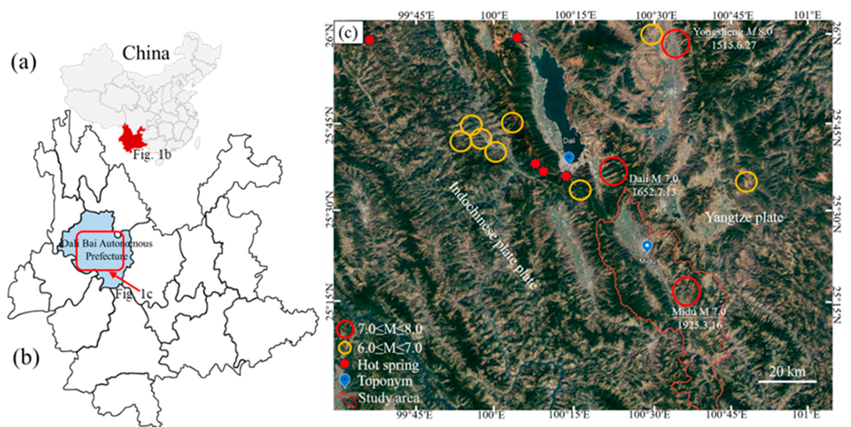
Figure 2.
a. Map showing the distribution of major faults in the Midu area. b. East-west cross-sectional profile of the Midu basin [modified from19].
Figure 2.
a. Map showing the distribution of major faults in the Midu area. b. East-west cross-sectional profile of the Midu basin [modified from19].
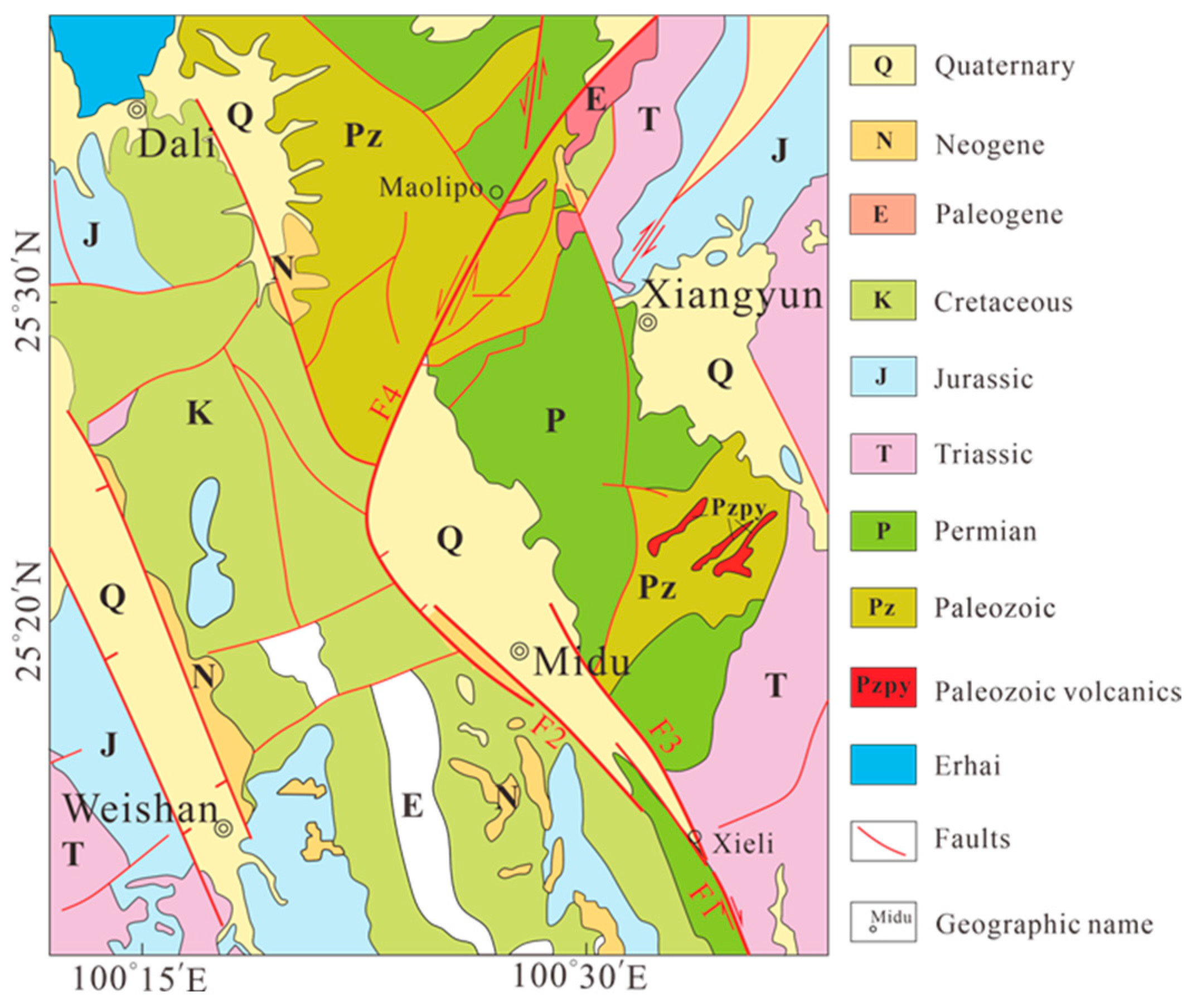
Figure 3.
Locations of the seismic stations of Midu geothermal field. (Triangles indicate stations; Red line indicates fault; Velocity profile taken along the white dashed line in the next section).
Figure 3.
Locations of the seismic stations of Midu geothermal field. (Triangles indicate stations; Red line indicates fault; Velocity profile taken along the white dashed line in the next section).
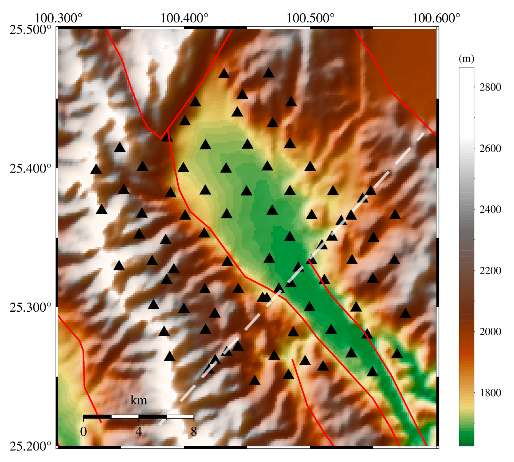
Figure 4.
Monitoring period station locations and local earthquake distribution in the Midu geothermal field research area. (a) Triangles and Stars represent stations and seismic events, respectively. The gray line indicates the picking traveltime from sources to stations(b) Green dots represent initial S-wave arrivals, while red dots represent initial P-wave arrivals.
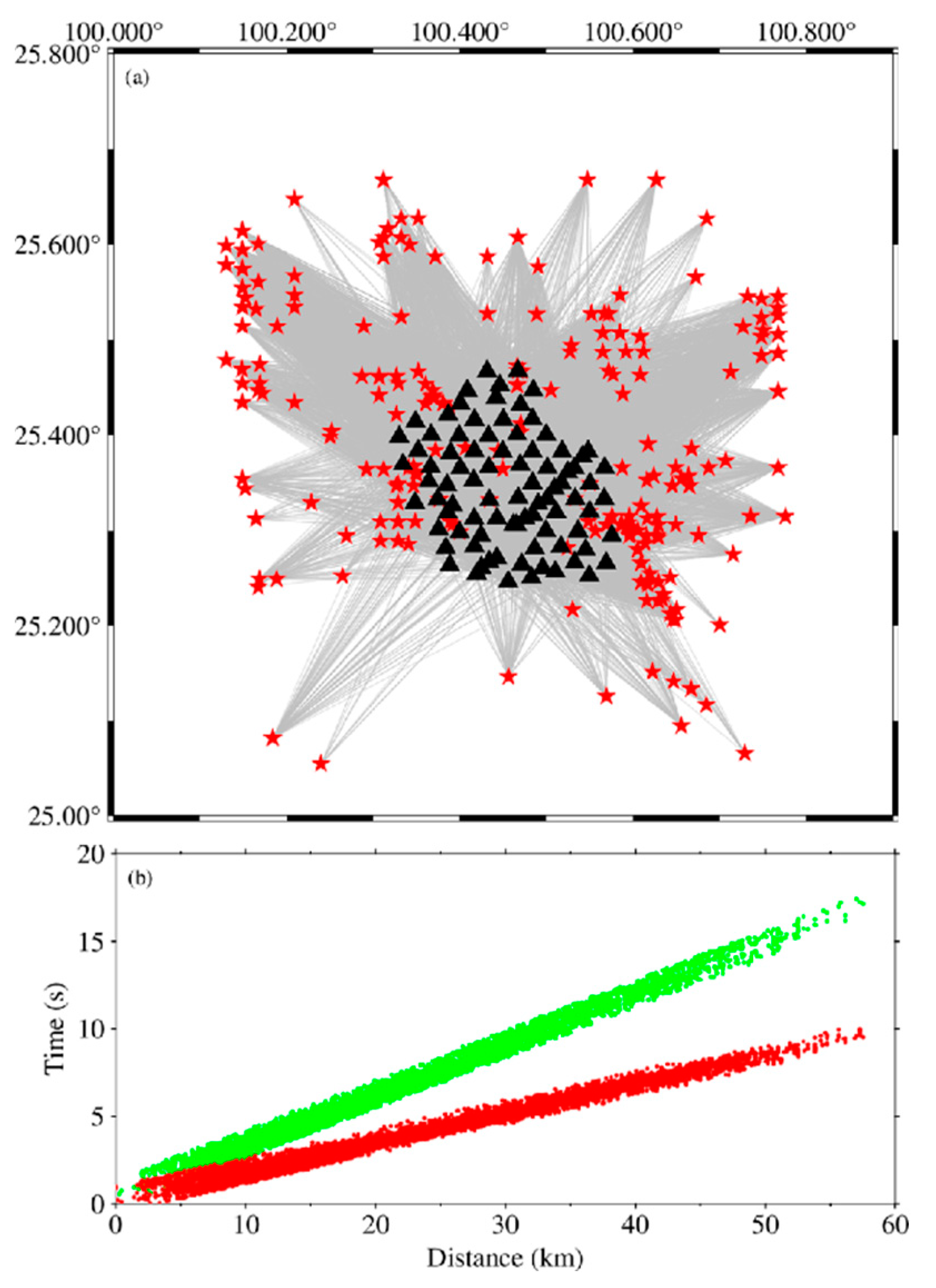
Figure 5.
depicts the average Vp/Vs and the selection of the initial P-wave velocity model, where (a) shows the yellow line as the Vp/Vs fitting line, and (b) shows the green line as the initial P-wave velocity model by Chen Siwen et al., and the black line represents the initial velocity model used by Zhang Yunpeng et al. for the dense station tomographic imaging in Binchuan, which is also the initial velocity model used in this study.
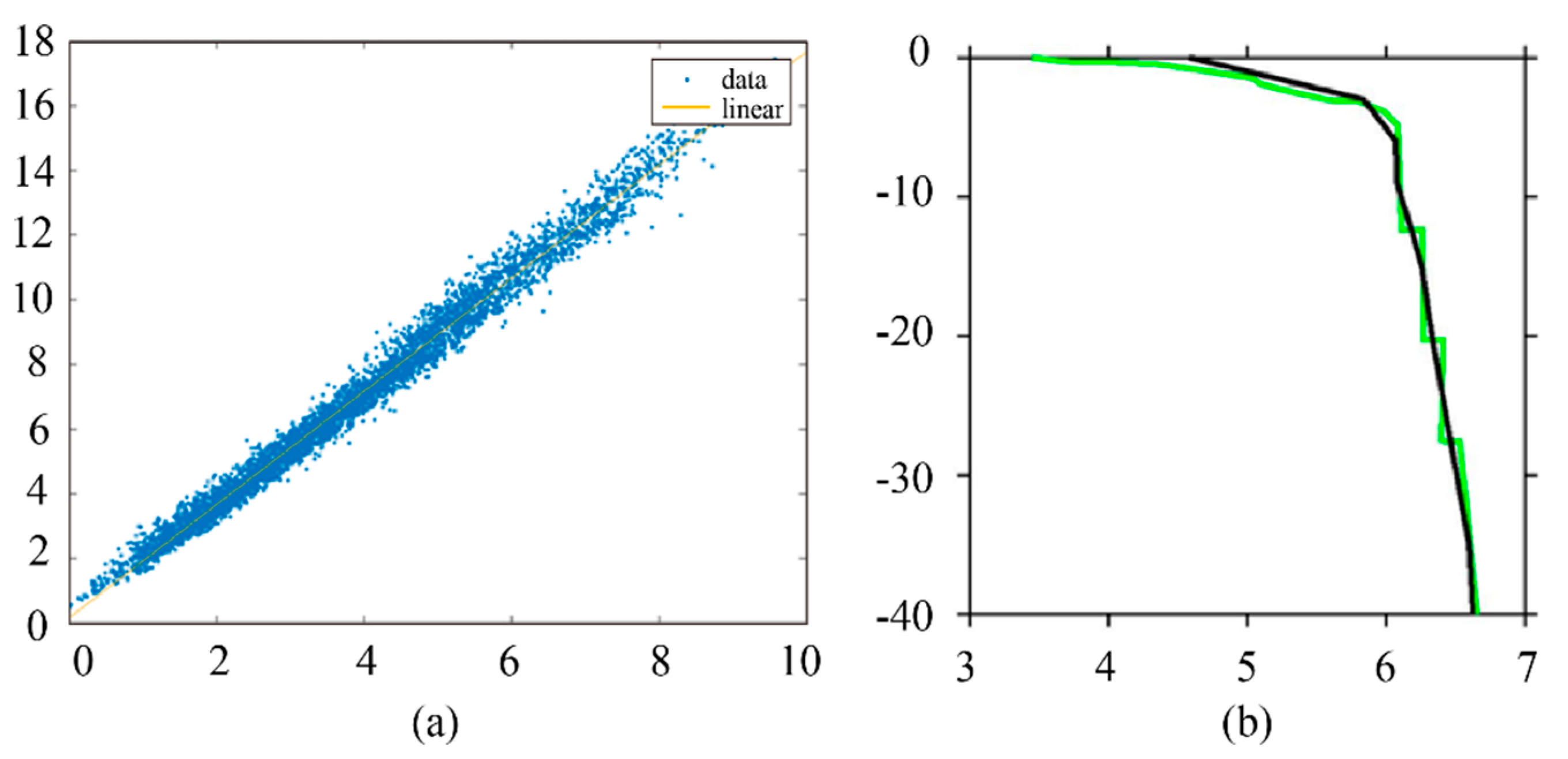
Figure 6.
illustrates the selection of damping parameters and the distribution of residuals before and after inversion. (a) and (b) represent the trade-off curves between the data misfit and model variance for Vp and Vp/Vs, respectively; (c) and (d) depict the distribution of residuals before and after the inversion for P-wave and S-P.
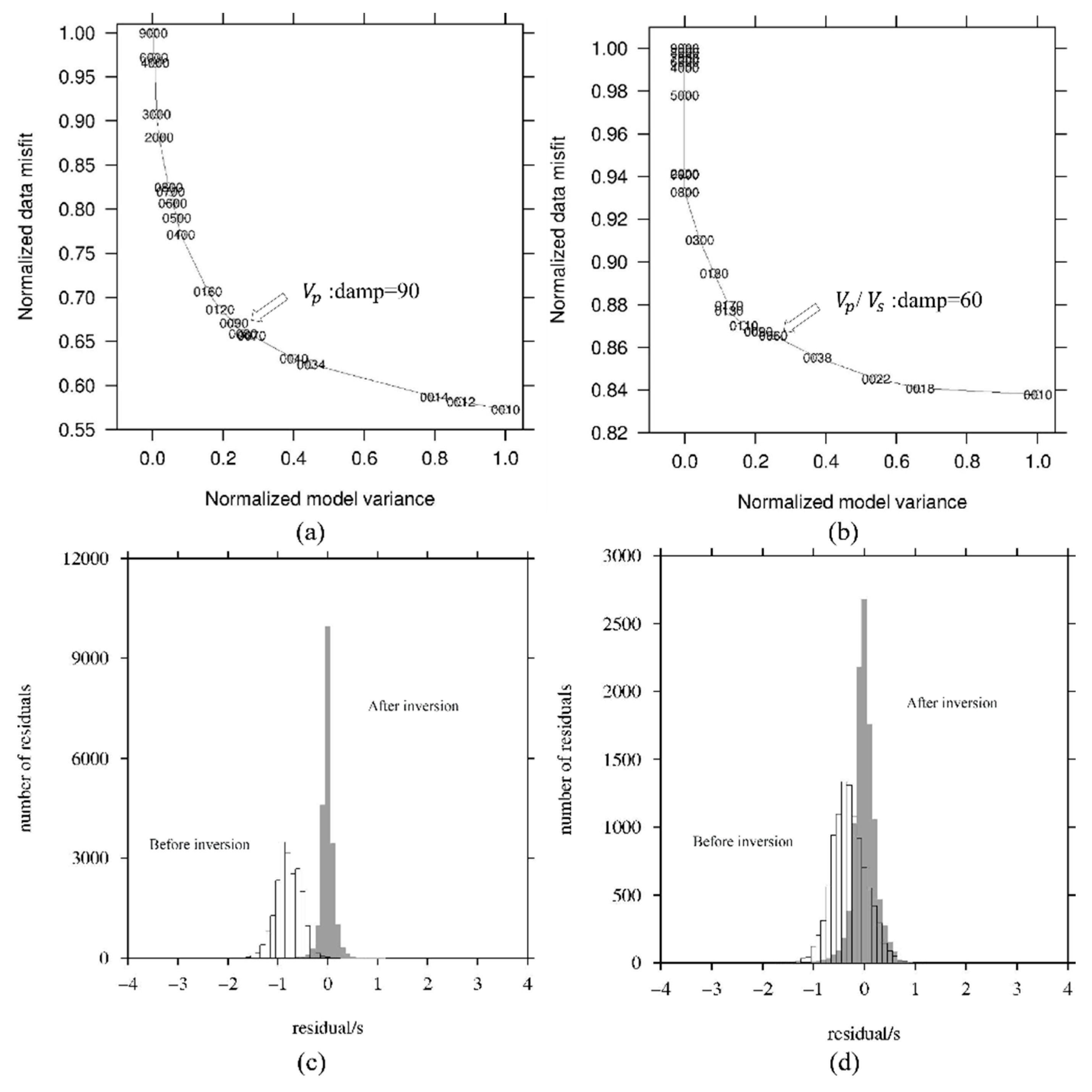
Figure 7.
illustrates the checkerboard test results for Vp and Vp/Vs at different depths. The theoretical model involved applying ±5% perturbations to Vp and Vp/Vs for adjacent grid cells. The blue contour lines envelope areas with a resolution greater than 0.1.
Figure 7.
illustrates the checkerboard test results for Vp and Vp/Vs at different depths. The theoretical model involved applying ±5% perturbations to Vp and Vp/Vs for adjacent grid cells. The blue contour lines envelope areas with a resolution greater than 0.1.
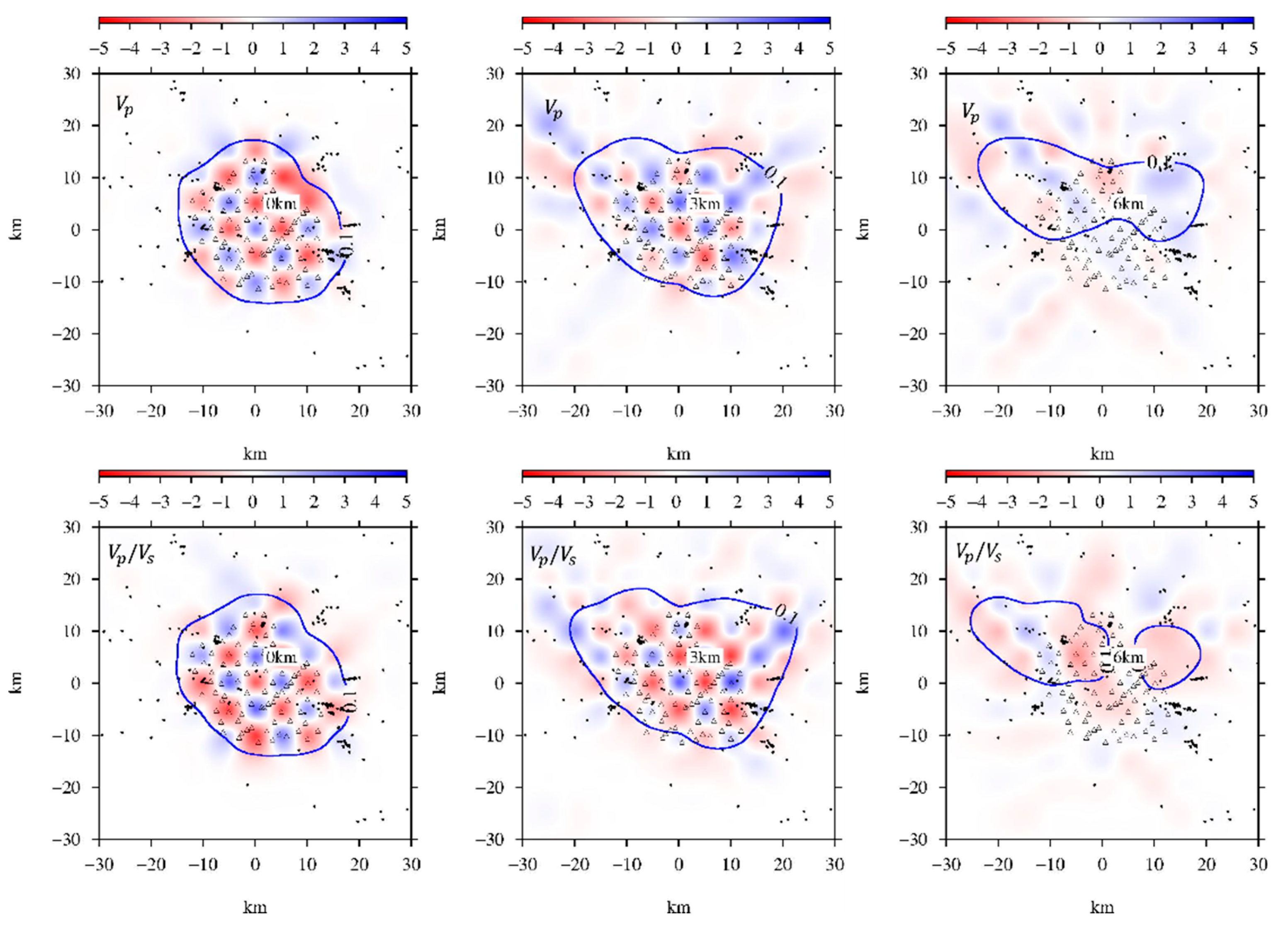
Figure 8.
illustrates the distribution of Vp and Vp/Vs at different depths. The purple contour lines envelope areas with a resolution greater than 0.1. The top right corner of each figure shows the average Vp and Vp/Vs values at that depth after inversion. The black triangles in each figure represent the seismometer stations.
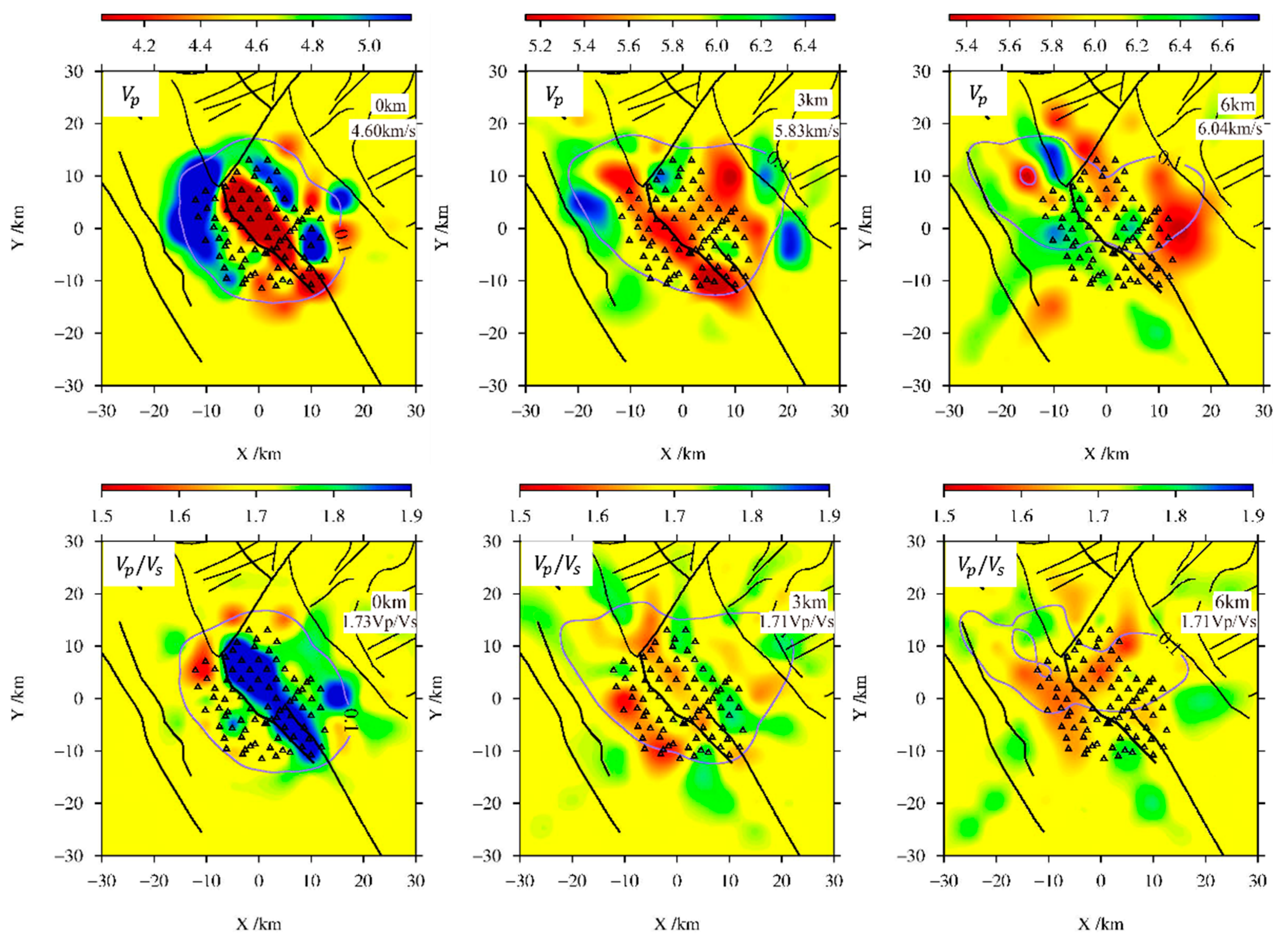
Figure 9.
The vertical cross-section of Vp (a) and Vp/Vs (b) model. The line of section is the white dashed line in Figure 3.
Figure 9.
The vertical cross-section of Vp (a) and Vp/Vs (b) model. The line of section is the white dashed line in Figure 3.
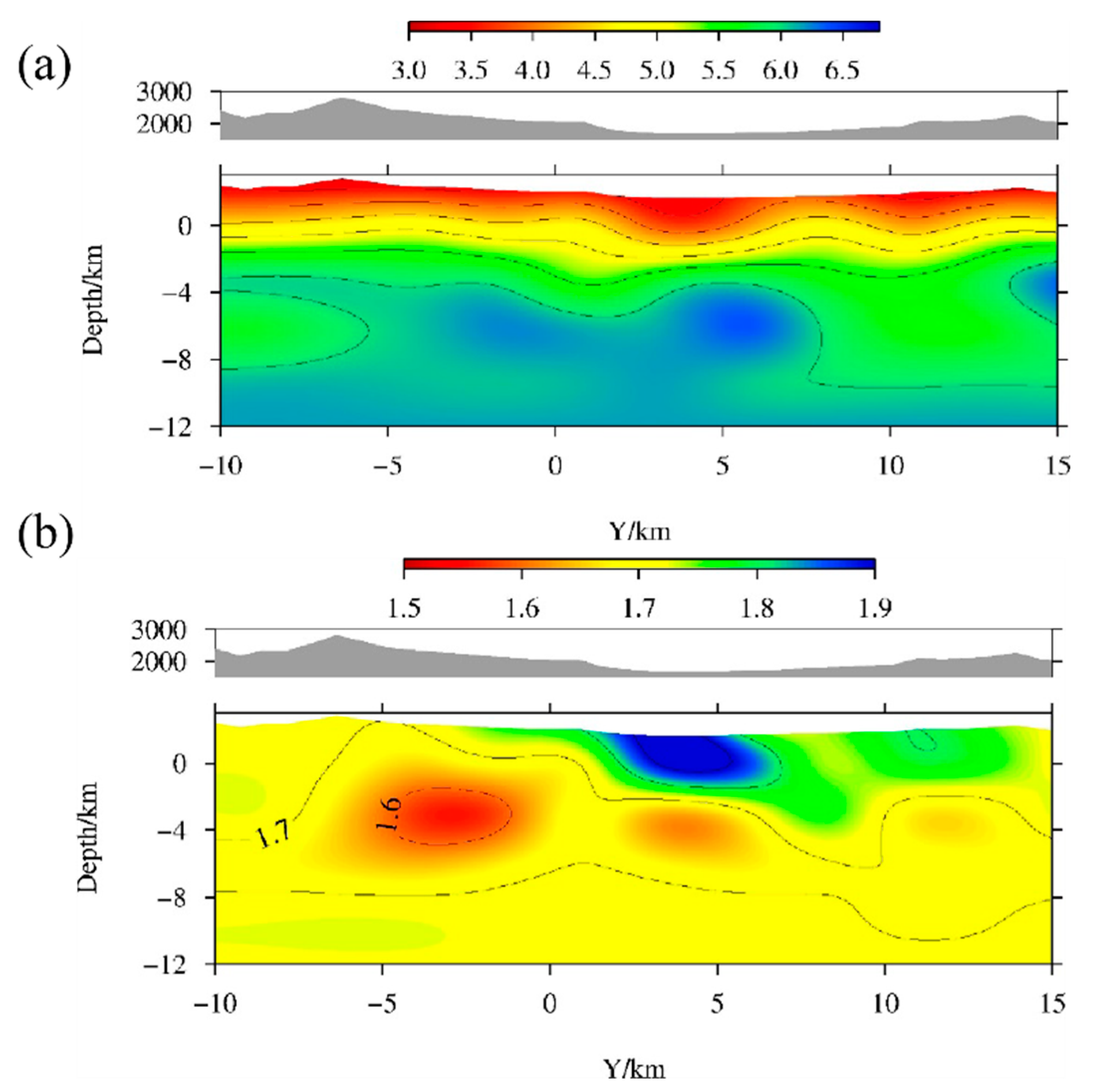
Figure 10.
Geothermal genetic model of Midu basin.
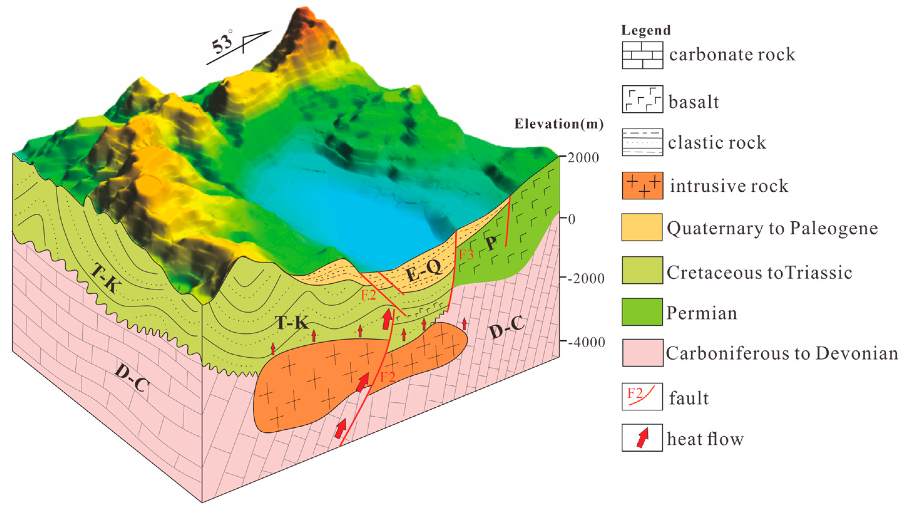
Figure 6.
illustrates the selection of damping parameters and the distribution of residuals before and after inversion. (a) and (b) represent the trade-off curves between the data misfit and model variance for Vp and Vp/Vs, respectively; (c) and (d) depict the distribution of residuals before and after the inversion for P-wave and S-P.
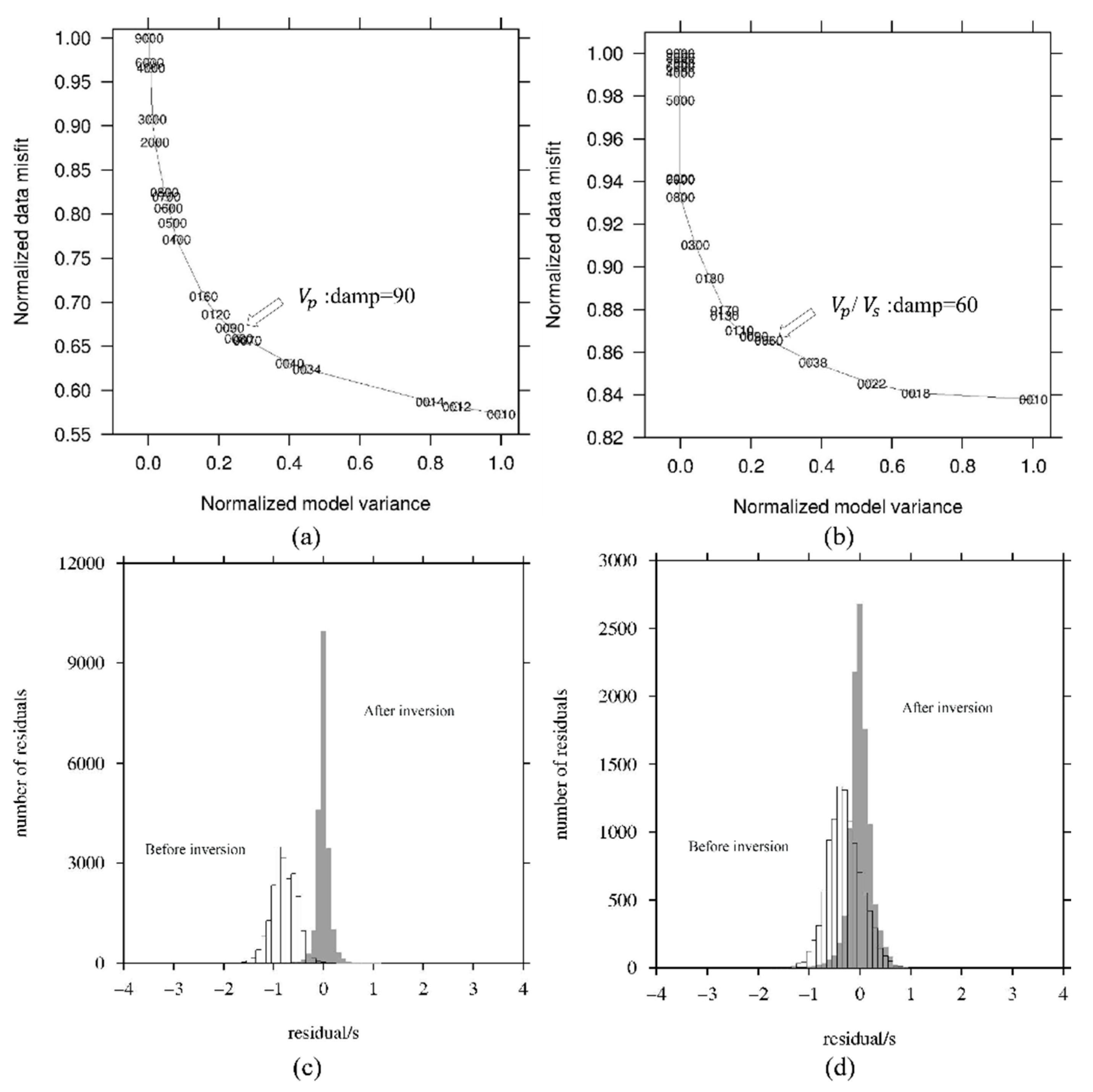

Table 1.
Parameters Related to Thermal Anomalies in Midu Basin.
| Number | Name | TOutlet | Type | TSiO2 | TNa-K | TNa-K-Ca | Altitude/m | D/m |
| 1 | Baizongqi | 57.0 | HCO3-Na | 96.1 | 201 | 209 | 1800 | 3287 |
| 2 | Xiashidong | 47.3 | HCO3-Na | 91.7 | 160 | 202 | 1750 | 2537 |
| 3 | Shizui | 36.1 | HCO3-Na | 107.3 | 187 | 306 | 1700 | 2804 |
| 4 | Gaoqing | 53.2 | HCO3-Na | 116.9 | 166 | 270 | 1696.5 | 3374 |
| 5 | Jinglong | 72.5 | HCO3-Na | 110.4 | 218 | 185 | 1675 | 3098 |
Disclaimer/Publisher’s Note: The statements, opinions and data contained in all publications are solely those of the individual author(s) and contributor(s) and not of MDPI and/or the editor(s). MDPI and/or the editor(s) disclaim responsibility for any injury to people or property resulting from any ideas, methods, instructions or products referred to in the content. |
© 2024 by the authors. Licensee MDPI, Basel, Switzerland. This article is an open access article distributed under the terms and conditions of the Creative Commons Attribution (CC BY) license (http://creativecommons.org/licenses/by/4.0/).
Copyright: This open access article is published under a Creative Commons CC BY 4.0 license, which permit the free download, distribution, and reuse, provided that the author and preprint are cited in any reuse.


