
Submitted:
22 July 2024
Posted:
22 July 2024
You are already at the latest version
Abstract
The Arabian Desert is characterised by very low rainfall and high evaporation, yet on its northeastern edge in central Iraq are 210 springs along the Abu Jir lineament, which represents the western depositional margin of a foreland basin infilled by the floodplain sediments of the Tigris and Euphrates Rivers; there is little evidence of faulting. The springs discharge from gently east-dipping Paleocene-Eocene limestones, either where groundwater flowpaths intersect the ground surface or where groundwater flow is forced to the surface by confining aquitards. Calculated annual recharge to the aquifer system across the Arabian Desert plateau (130-500 million m3) is enough to sustain the Abu Jir springs provided groundwater extraction is not excessive. The hydrochemistry of the springs is determined by evaporation, rainfall composition (high SO4 concentrations are due to dissolution of wind-blown gypsum in the rainfall), and plant uptake of Ca and K (despite the sparse vegetation). Limestone dissolution has relatively little impact; many of the springs are undersaturated with respect to calcite and lack tufa/travertine deposits. The springs at Hit-Kubaysa contain tar and high levels of H2S that probably seeped upwards along subvertical faults from underlying oil reservoirs; the presence of hydrocarbons makes the water reducing and converts the dissolved SO4 to H2S.
Keywords:
Iraq
; springs
; hydrochemistry
; hydrogeology
; recharge
1. Introduction
The Arabian Desert extends across much of Saudi Arabia and Iraq, and is characterised by very low rainfall, high evaporation and sparse vegetation. Nevertheless, along its northeastern edge in central Iraq there is an extensive line of 210 springs along the northwest-southeast geographical divide between the desert and the fertile Mesopotamia plains of the Euphrates and Tigris Rivers (Figure 1). These springs also lie along a cultural divide between the desert, the realm of nomadic people, and the floodplain, where a reliable supply of water allowed for the development of the flourishing permanent human settlements [1].
For this study we carried out the first comprehensive mapping of the Abu-Jir Springs and integrated this with a reassessment of the significant amount of available data on the springs, in order to determine the reasons for their existence in such an arid region.
The linear feature associated with the springs is generally identified as a major fault [the Abu Jir Fault, e.g.] [2]. However, geological mapping has failed to identify a near-surface rupture that coincides with the springs e.g. [3], so the interpretation of this fault seems to be largely conjectural. To understand the nature of the geomorphological/geological structure associated with the springs, we reassessed the regional geological mapping and seismic data for the area.
The springs are supplied by groundwater from the Umm er Radhuma - Dammam aquifer underlying the Arabian Desert to their west [4]. This aquifer is exploited by recent extraction for irrigated agriculture in some areas [5,6], although much of the groundwater from the aquifer is saline [7]. The exploitation has impacted many of the springs and has been regarded as unsustainable. However, the potential recharge area of the aquifer feeding the springs is enormous, even though it coincides with a landscape of very low rainfall. Here we assessed the sustainability of the springs under current rainfall using two different methods to calculate the recharge potential.
The chemical composition of the springs is characterised by high levels of SO4 and often high salinity; the Hit-Kubaysa springs also contain tar and H2S. The interpretation of these characteristics has invoked many different processes: evaporation [7,8], dissolution of gypsum [7,9], evaporites [7] and carbonates [5,7,8], input of connate sea water [10,11], and, for the Hit-Kubaysa springs, input of petroleum and brines from reservoirs deep beneath the springs [12]. Here we reassess the hydrochemical evidence using new methods of interpretation, including comparison with rainfall composition, as this is essential to determining which species in solution were derived from rainfall and which from rock-water interactions in the aquifers.
2. Materials and Methods
Mapping of the springs used the CORONA satellite photography derived from the United States intelligence program of satellite reconnaissance from 1959 to 1972 [13,14], and was verified by fieldwork for many springs during this study. The CORONA images dating from August 1968 are essential for locating the springs on the Abu Jir lineament because they predate groundwater extraction for agricultural development that has deactivated many springs. Mapping was also informed by the detailed map and journal compiled by Alois Musil, a Czech theologian and explorer who made multiple journeys through the Middle East. He travelled south-east along the Abu Jir lineament in 1912, providing locations and names for the springs [15].
Data on the hydrogeology of the region and the spring hydrochemistry was obtained from existing published sources and then integrated and reassessed. For the hydrochemical study, the median composition of spring water from four different sets of springs along the Abu Jir lineament (Hit-Kubaysa, Haqlaniyah, Shinafiyah and Najaf) was compared with rainfall (obtained at Riyahd) and seawater using a standardised Schoeller plot. A Schoeller plot is a semi-logarithmic diagram of species concentrations from multiple samples, with the advantage that, unlike trilinear plots, actual concentrations are displayed [16]. The analyses in the present study were standardised to the Cl- value of rainfall. This removes any influence of evaporation [17], i.e. if the spring waters represented just evaporated rainwater, with no other influence on their chemistry, all lines on the Schoeller plot for spring water would plot over the top of the rainfall line. This procedure assumes that all Cl- arrives in rainfall and that processes in the soil or aquifer (apart from evapotranspiration) do not affect the Cl- concentration.
Saturation indices (SI) with respect to calcite were calculated for the spring water compositions [18]:
where
The recharge for the springs was calculated using two methods. The first, the chloride (Cl-) mass balance (CMB) method [19,20], is based on the relationship between Cl- concentrations in groundwater and in precipitation (rainfall) (Equation 3). As for the Schoeller plot, this calculation assumes that all Cl- in the groundwater is derived from rainfall and remains in solution within the groundwater system and that there is no significant loss of chloride in runoff:
The second method for calculating recharge used the empirical relationship between rainfall and recharge derived by MacDonald et al. [21]:
3. Abu Jir Springs
The Abu Jir springs total 210 in number and lie along the Abu Jir lineament, which extends in a slightly arced line for ~520 km (Figure 1). The maximum distance between springs along the lineament is 42 km north of Razazza Lake, and the maximum width across the complex of springs is 26 km in the Hit-Kubaysa area. The springs are closely aligned with the western edge of the Mesopotamian floodplain (Figure 2), which is here called the Abu Jir lineament (discussed further below).
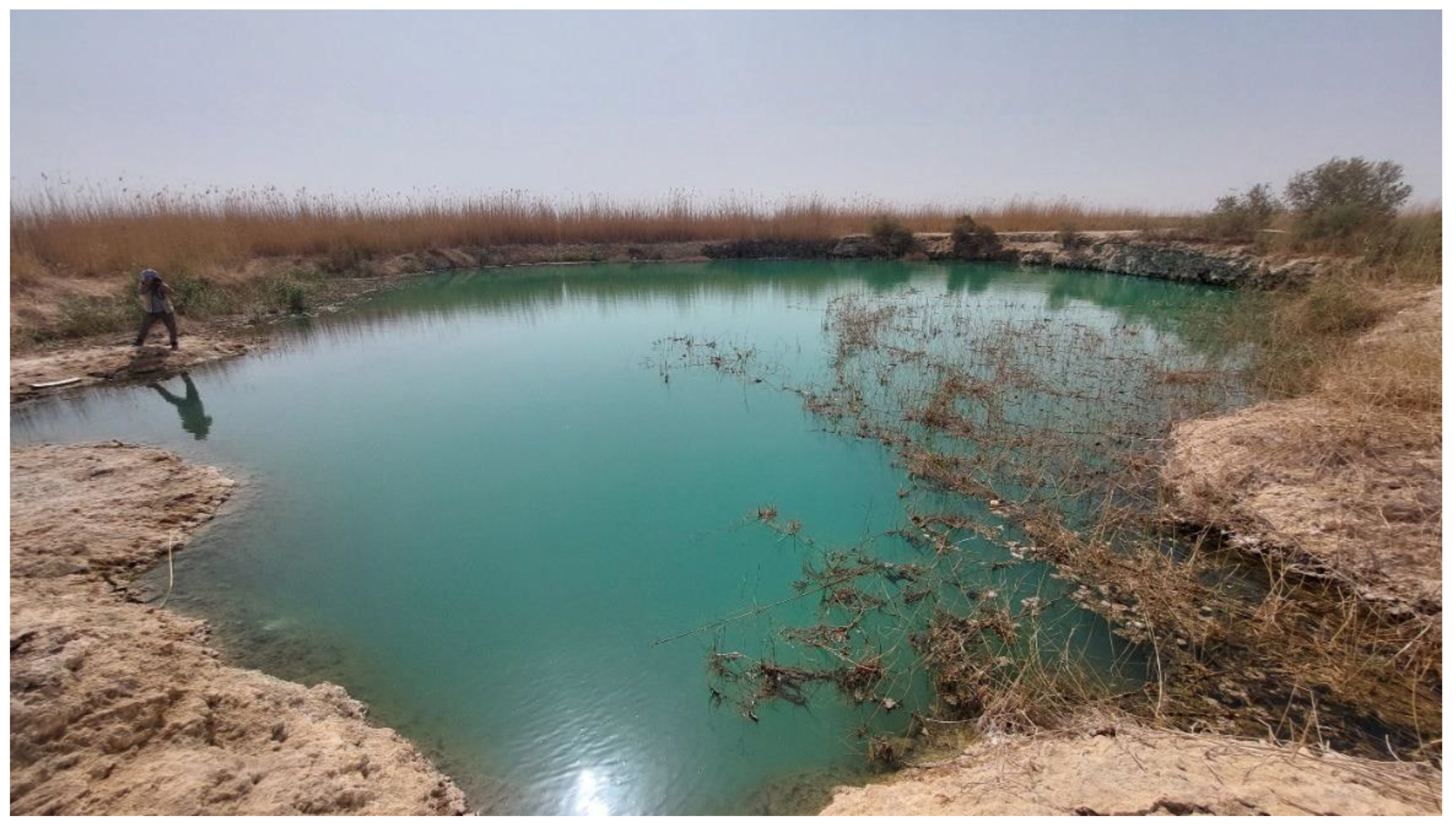
In general, the springs have low flows, with an average discharge of <1 L/sec, and provide little inflow to the Euphrates River, which is mostly located to the east of the spring line (Figure 1). At Haqlaniyah and Hit, the springs provide a minor inflow to the main channel of the river, and to the north-west of Qaryat al Gharab the springs occur either side of the Al-Atshan River, a channel of the main Euphrates stream crossing an area of marshland. The springs do not discharge into most of the large ephemeral salt lakes to the east of the lineament, although a spring that provides a groundwater source for Sawa Lake is occasionally exposed when the lake levels recede (Figure 3). Some springs have associated travertine deposits, especially near Hit and Abu Jir (Figure 1).
3.1. Geological and Geomorphological Setting
The geology and geomorphology of Iraq are the result of its tectonic history, in particular the collision between the Arabian and Eurasian plates during the Alpine Orogeny, which began in the Early Paleogene, with a significant phase in the Pliocene – Early Pleistocene [22,23]. Tectonism continues today; the Arabian Plate is still moving northeastwards at ~1.5 cm/year. The thrusting of the Eurasian Plate over the Arabian Plate formed, in increasing distance from the collision zone (i.e. northeast to southwest), the Zagros fold and thrust belt, the Mesopotamian foredeep and the inner Arabian platform [23,24] (Figure 4). These three tectonic units correspond to the three major geomorphic subdivisions of Iraq (Figure 2). In the northeast are the rugged peaks and linear ridges of the Zagros Mountains, uplifted by the collision and rising to over 3,000 m. To the southwest is the flat Mesopotamian Plain, almost entirely <100 m in elevation, which slopes very gently towards the Persian Gulf; it is crossed by the Tigris and Euphrates Rivers [22]. Beneath the plain are gently folded Cretaceous limestones and sandstones that are important oil reservoirs in central and southern Iraq [25]. The Mesopotamian Plain represents a foreland basin that subsided in front of the rising Zagros Mountains and was infilled by the floodplain sediments of the rivers. To the southwest is the Arabian desert plateau, rising slowly westwards to over 800 m at the border with Saudi Arabia, and composed largely of Paleogene and Neogene carbonate sediments that dip very gently eastwards.
Figure 1.
Location of springs (blue dots) along the Abu Jir lineament, and modern cities (squares). For location see Figure 4.
Figure 1.
Location of springs (blue dots) along the Abu Jir lineament, and modern cities (squares). For location see Figure 4.
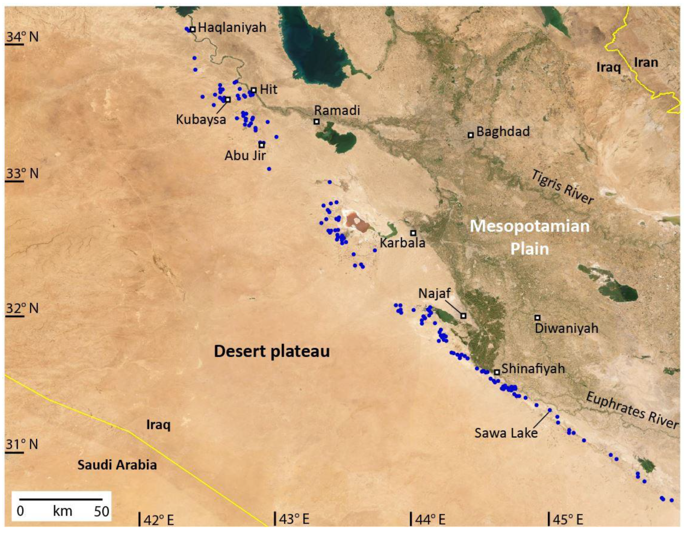
Figure 2.
Topography of central Iraq, showing the three major geomorphic sub-divisions, springs (white dots) located along the Abu Jir lineament, and the locations of the cross-sections in Figure 5. For location, see Figure 4.
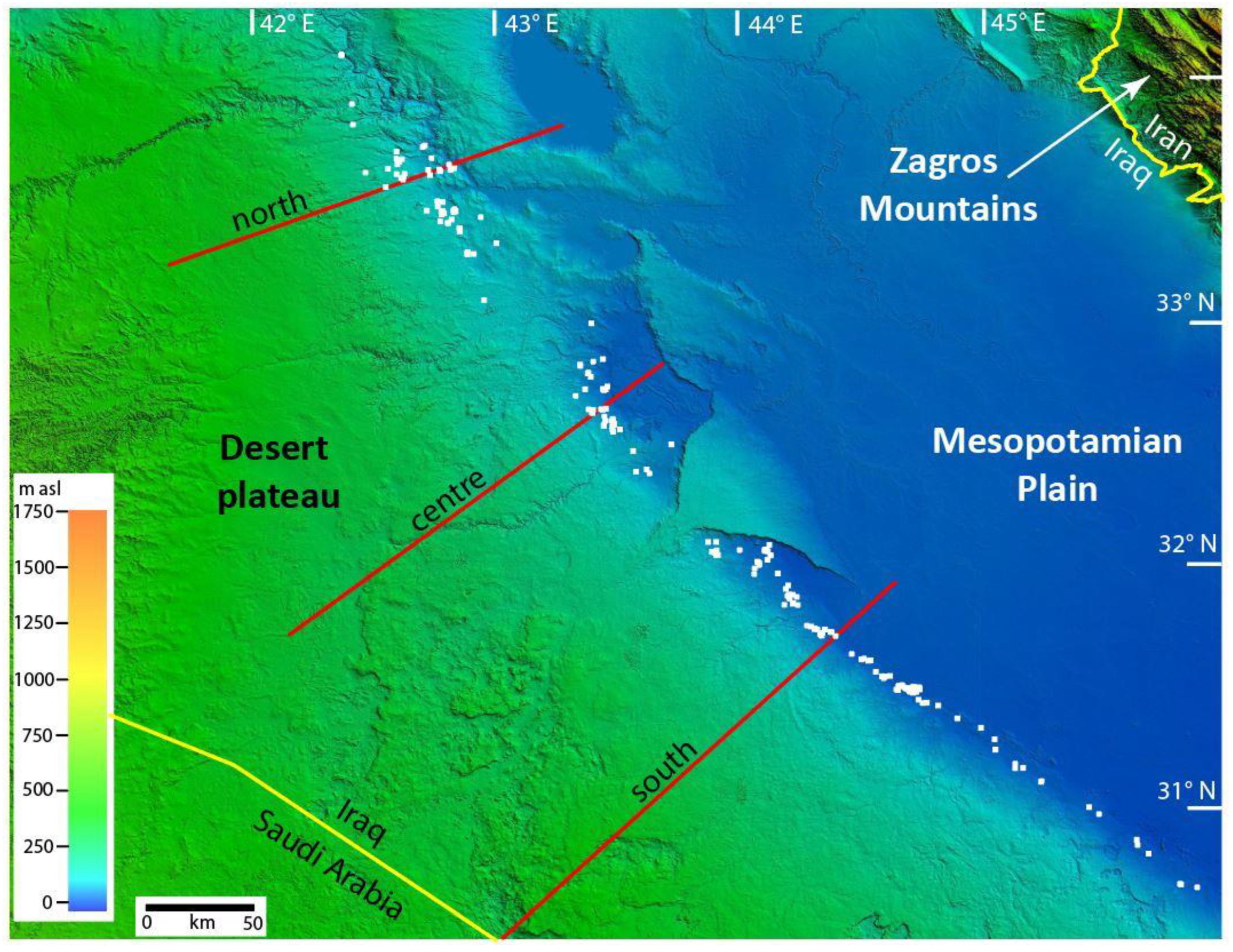
Figure 3.
Spring exposed in the bed of Sawa Lake when the lake receded (see Figure 1 for location).
Figure 3.
Spring exposed in the bed of Sawa Lake when the lake receded (see Figure 1 for location).
The well-defined topographic boundary between the Mesopotamian Plain and the desert plateau, which trends northwest-southeast for ~520 km (Figure 2), is referred to here as the Abu Jir lineament, because it is a well-marked linear feature. It has also been called the Abu Jir Fault e.g. [24], but there is little evidence of surface displacement along most of the lineament [28], and cross-sections on the 1:250,000 geological maps covering the lineament show uninterrupted east-dipping strata e.g. [3]. Even in the Hit-Kubaysa area, where there is evidence of hydrocarbon leakage up steeply dipping faults along or close to the lineament, no displacement has been documented at the surface [8,29]. Seismic sections show that right-lateral strike-slip faults (flower structures) exist at depth beneath the Abu Jir lineament [28], but these have minimal vertical displacement and also occur beneath the Mesopotamian Plain [30].
To confirm this interpretation, new cross-sections were constructed along the lineament using all available geological and geomorphological information (Figure 5); these show clearly that the Abu Jir lineament does not coincide with a fault. It is instead a topographic feature which forms the western edge of the floodplains of the Tigris and Euphrates Rivers. It therefore represents the western depositional margin of the foreland basin (Mesopotamian Plain) that subsided in front of the rising Zagros Mountains as the Eurasian Plate was thrust over the Arabian Plate, and was infilled by the floodplain sediments of the rivers.
To the west of the Abu Jir lineament is the Arabian Desert plateau (Figure 2). This has very low relief, increasing gradually westwards in elevation from ~100 m at the lineament to over 800 m at the border with Saudi Arabia. The exposed strata in the eastern part of the plateau are predominantly carbonates of Paleocene to Miocene age (Figure 4); older sediments of Permian to Cretaceous age (mostly carbonates) outcrop to the west. The northeastern part of the plateau is dissected by shallow valleys running northeastwards; elsewhere it is characterised by a rocky surface with numerous solution features such as karst depressions (dolines) (Figure 2), some of which lead to caves. On the desert plateau in eastern Saudi Arabia, horizontally developed shallow caves and vertical shafts have been reported; these are believed to have formed predominantly during wetter climate phases in the Pleistocene [31,32].
3.2. Hydrogeological Setting
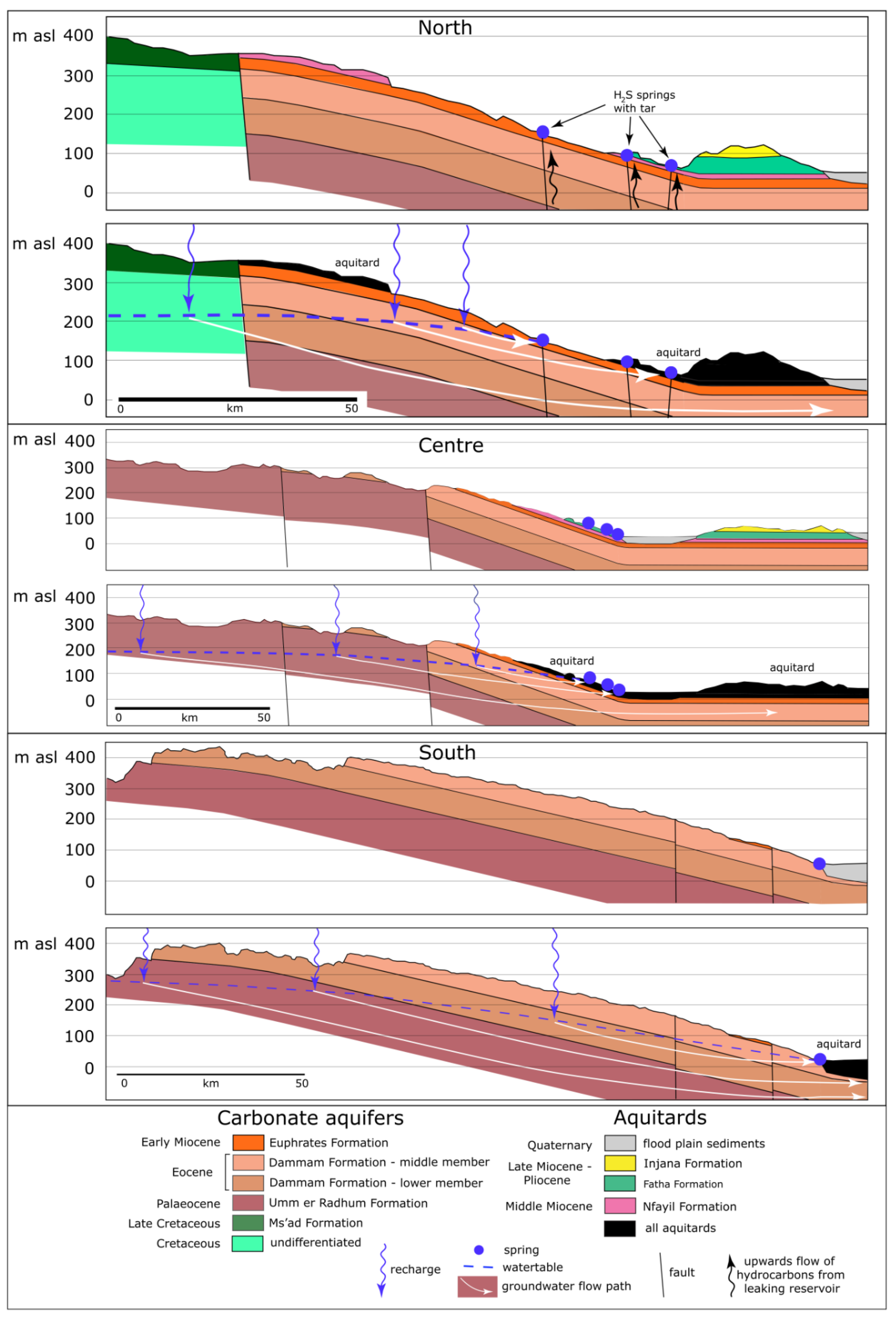
The hydrogeology of the springs along the Abu Jir lineament is determined by the geology of the Arabian Desert plateau, which represents the recharge area for the springs. Carbonate aquifers of Cretaceous – Miocene age are exposed across most of the plateau (Figure 4) and extend continuously eastwards beneath the clay-rich aquitard of the Quaternary sediments of the Mesopotamian Plain (Figure 5). Miocene-Pliocene aquitards overlie the carbonate aquifers in places along the easternmost margin of the desert plateau, close to the Abu Jir lineament (Figure 5) [4].
Figure 4.
Geology of the desert plateau west of Abu Jir lineament [after 23,26,27], showing location of Figure 2 and the stratigraphic profiles in Figure 5.
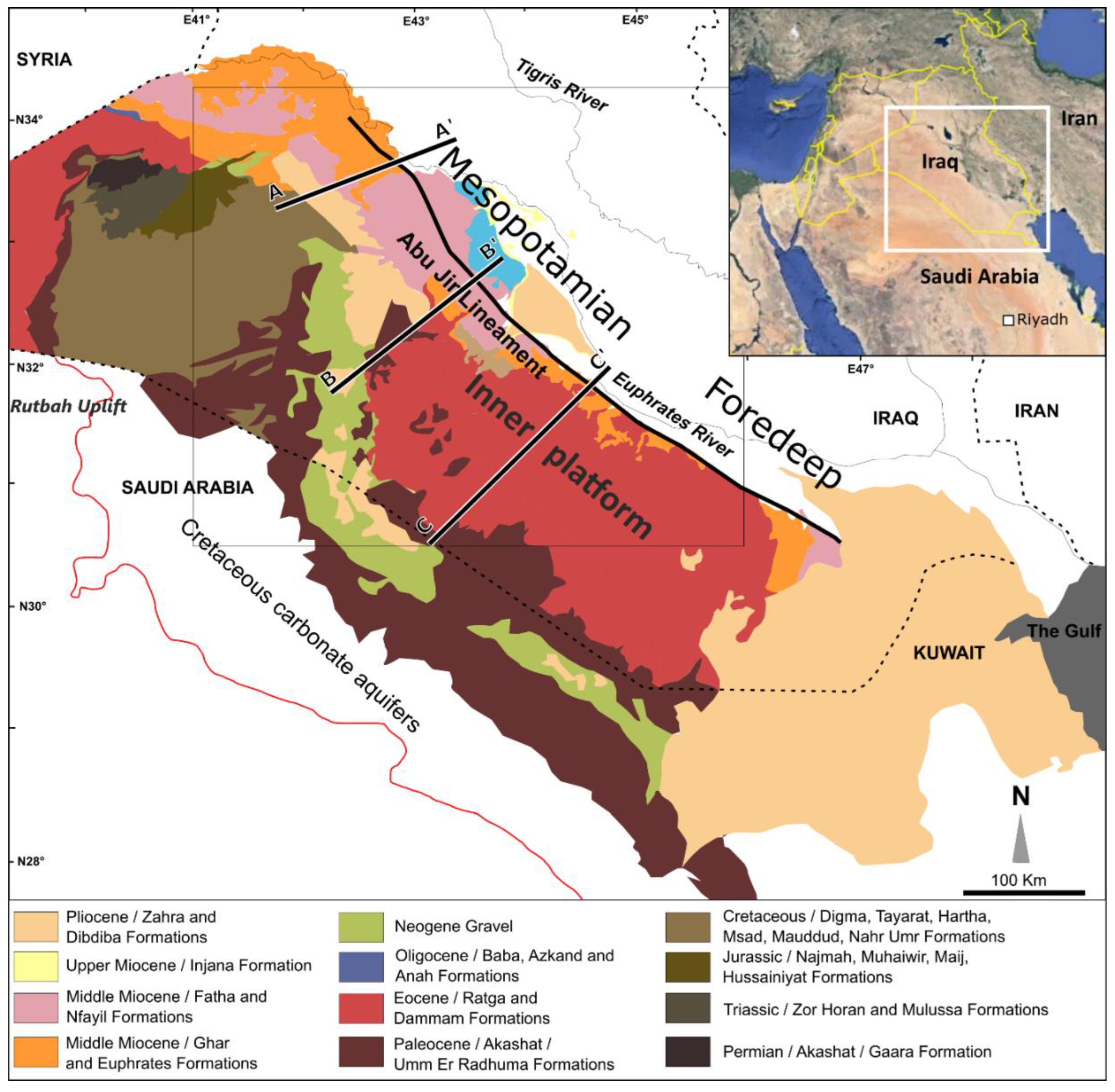
Figure 5.
Geological cross-sections along the Abu Jir lineament (for locations see Figs 2,4), showing the hydrogeology of the springs. Note the vertical exaggeration (x82); the actual westwards dip of the strata is <1°. Stratigraphy derived from the outcrop distribution and bore logs on the following 1:250,000 geological maps: Karbala [33], Al Najaf [34], Baghdad [35], Al Birreet [36], Al Ramadi [37], Shithatha [38].
The oldest carbonate units that form significant aquifers are Cretaceous in age; these outcrop in the central and western parts of the desert plateau. In stratigraphic order these are the Mauddud Formation (up to 50 m of thick horizons of limestone and marl), Rutbah Formation (sandstone and some limestone, 20-30 m thick) and Ms’ad Formation (about 65 m of limestone with thin sandstone tongues) [2]. These are overlain by the Late Cretaceous Hartha, Tayarat and Digma Formations, with a total thickness of >100 m; all of these units contain marl horizons, particularly the Digma Formation, that may act as aquicludes separating the Cretaceous aquifers from younger Paleogene aquifers.
The two main aquifers of the desert plateau are the Paleocene Umm Er Radhuma Formation and the Eocene Dammam Formation [4] (Figs 4,5). Over most of the plateau the Dammam Formation directly overlies the Umm Er Radhuma Formation [2], and the two form a single unconfined aquifer system. The Umm Er Radhuma Formation consists of microcrystalline, porous, anhydritic and dolomitic limestones, mostly dull white or buff, with a thickness of 120-180 m. The Dammam Formation comprises whitish grey, porous, dolomitized limestone, sometimes chalky, and is up to 225 m thick. Two members of the Dammam Formation are exposed in the eastern and southern parts of the desert plateau, a Lower Member of whitish grey fossiliferous (nummulites) limestone, and a Middle Member of white, massive shelly limestone; shells are mainly oysters with few small nummulites [2].
Overlying the Dammam Formation is the Early Miocene Euphrates Formation, which consists of white and grey fossiliferous limestone and dolomite. Although it can be over 100 m thick, it is generally much thinner. This formation is also an aquifer, so it represents an additional part of the Umm Er Radhuma Formation / Dammam Formation aquifer system.
The porosity and permeability of the carbonate aquifers are due to both dissolution cavities and tectonic fractures [39]; as a result the hydraulic conductivity of the Umm Er Radhuma and Dammam Formations can reach 20 and 100 m/day respectively [4]. The Middle Member of the Dammam Formation in the vicinity of the Abu Jir lineament has an average porosity of 22% and hydraulic conductivity of 6 m/day [3]; to the south in Kuwait the porosity and permeability of the Dammam Formation can be as much as 53% and 5 m/day respectively [40].
Groundwater flow within the carbonate aquifers beneath the desert plateau follows the topographic gradient, flowing from southwest to northeast in the northern part of the plateau and west to east in the south [4]. The watertable within the unconfined carbonate aquifers lies up to 300 m below the ground surface along the Saudi Arabian border, and approaches the surface towards the east, as it slopes gently towards the Abu Jir lineament (Figure 5); the slope of the watertable is gentler than that of the topography. East of the lineament the Umm Er Radhuma and the Dammam Formations extend continuously beneath the sediments of the Mesopotamian Plain as a confined aquifer [4] (Figure 5), and bores within these units close to the lineament are often artesian [3,41].
Along the eastern edge of the desert plateau the Umm Er Radhuma / Dammam / Euphrates Formation aquifer system is overlain by several thin, Middle and Late Miocene clay-rich units that together form an aquitard (Figure 5): Nfayil Formation (green marl, grey limestone and red-brown mudstone), Fat’ha Formation (green marl and bedded limestone) and Injana Formation (red brown mudstone and sandstone). Each of these units is typically only a few meters thick.
East of the Abu Jir lineament, beneath the Mesopotamian Plain, the Paleogene-Neogene carbonate aquifers are unconformably overlain by Quaternary floodplain muds and sands (Figure 5), up to 100 m thick, forming an extensive aquitard.
3.3. Hydrogeology of Abu Jir Springs
Along the southern part of the Abu Jir lineament, the springs are mostly sited at the break in slope between the desert plateau and the Mesopotamian Plain. Here the carbonate aquifers outcrop right up to the lineament (Figure 5), so the boundary between the aquifers and the aquitard of the flood plain sediments lies directly along the lineament. The effect of the clay-rich aquitard sediments of the floodplain is to impede the eastward groundwater flow and force the groundwater to the surface as springs, which are therefore located where the watertable intersects the ground surface (Figure 5). Many of the springs are probably fed by conduits dissolved in the limestone, accounting for their occurrence as discrete vents rather than strike-parallel linear seeps.
In contrast, further north along the Abu Jir lineament the springs are located both at the break in slope and 10 km or more to the west (upslope), due to a different geological setting. In the north the carbonate aquifers are overlain by Miocene aquitards along the base of the slope immediately west of the Abu Jir lineament (Figure 5); these aquitard outcrops raise the watertable and force the springs higher up the slope. As a result, the springs occur at the upslope extent of the aquitard outcrops, but also lower down the slope, where they have broken through the thin aquitard beds. As in the southern area, the springs are most likely conduit fed.
Among the northern springs are the Hit-Kubaysa springs, which are notable for their tar and H2S content [12]. These springs may lie along faults that allow upwards leakage of hydrocarbons from reservoirs beneath (Figure 5) (discussed further below). However, there is no evident surface displacement of the carbonate aquifers in this area [8,29], so the role of the faults in determining the spring locations is uncertain.
3.4. Recharge to the Abu Jir Springs
Although the Umm er Radhuma - Dammam aquifer system has recently been categorised as non-renewable [42], recharge is demonstrably occurring at present, as shown by the presence of measurable tritium in the groundwater, indicating recharge in the last 50 years [43,44]. To estimate this recharge, the chloride (Cl-) mass balance method (Equation 3) was applied, using the precipitation-weighted mean Cl concentration of rainfall in Iraq and Saudi Arabia [10-20 mg/L; 45,46,47], the average chloride concentration of springs at Najaf (Table 4) and groundwater in the Dammam Formation [588 and 980 mg/L respectively; 48], and the average annual rainfall of the desert plateau (100 mm; ranging from 64 mm at Ar’ar in Saudi Arabia to 142 mm on the eastern edge of the desert; much of the rain falls during erratic events of >50 mm). This gave an annual recharge of 1-3.4 mm.
Employing the MacDonald et al. [21] empirical relationship between rainfall and recharge (Equation 4), using the average annual rainfall of the desert plateau, gave an annual recharge of 4 mm. The results of both calculations are close to the measured average recharge of 2.2 mm/yr on the Arabian Peninsula to the southeast [44].
The overall annual recharge to the Neogene carbonate aquifer can be calculated from these recharge estimates and the catchment (outcrop) area in Iraq and immediately across the border to the southwest in Saudi Arabia, which is ~123,000 km2, giving an overall annual recharge of 126-420 million m3 (344-1150 ML/day). If the outcrop of the Cretaceous carbonates to the west in Saudi Arabia is included, the catchment area increases to 208,000 km2 and the annual recharge rises to 210-700 million m3 (580-1900 ML/day).
The recharge over the desert plateau occurs despite the low rainfall (50-150 mm) and the very high evaporation (>2000 mm). This is probably because much infiltration occurs rapidly through the outcrop, assisted by the numerous karst dolines scattered over the plateau, which funnel rainfall underground, so that the amount of recharge after rainfall events can be substantial [43]. In the southwestern part of the plateau, within Saudi Arabia, recharge also occurs directly through overlying sand dunes [43].
If all the recharge to the Neogene carbonates discharged at the 210 springs along the Abu Jir lineament, it would give an average spring flow of 20-60 L/sec (1.6-5.5 ML/day). This is much greater than the average spring discharge of <1 L/sec [0.04-20 ML/day, average <0.1 ML/day; 12,49,50]. The total volume of discharge through the springs has been estimated as only 137 ML/day [42]. Spring discharge may have been substantially greater prior to extraction for agriculture in some areas, but the excess of recharge over spring discharge indicates that the bulk of groundwater flow through the Umm er Radhuma - Dammam aquifer system bypasses the springs and probably flows through the carbonates beneath them (Figure 5).
3.5. Hydrochemistry of the Abu Jir Springs
There is a high variability in the salinity of springs along the Abu Jir lineament and even between nearby locations, e.g. Hit-Kubaysa (Table 1), from high (>10,000 µS/cm at Hit), unsuitable for both drinking and irrigation, to moderate (>1800 µS/cm at Najaf). Even the latter levels are marginal for sustained irrigated agriculture, exceeding the recommended levels for drinking water in Europe and noticeably mineralized for unaccustomed users. Levels of fluoride and arsenic are low and safe for human consumption [8,29]. As would be expected, the springs’ salinity reflects that of the groundwater in the carbonate aquifers, which increases progressively from, on average, ~1000 mg/L in the west to over 5000 mg/L in the east towards the Euphrates River [4,43].
The spring water composition is dominated by high levels of SO4, along with significant concentrations of Ca, Cl, Na and Mg, and lower amounts of HCO3 and K (Figure 6, Table 1). All these species were derived from rainfall and rock-water interaction within the aquifers. There is no evidence of a contribution of connate seawater originally deposited with the marine carbonates of the aquifers, as hypothesised by al Dahaan [10] and al Dahan et al [11], because the maximum groundwater ages on the Arabian Peninsula are only 20,000-30,000 years [44,51], indicating that any connate seawater was flushed from the aquifers long ago.
To better understand the factors responsible for the chemical composition of the spring water, a standardised Schoeller plot was constructed (Figure 6), comparing the median major ion chemistry of the springs with that of the nearest available rainfall data on the desert plateau at Riyadh [34] (Table 1); all analyses were standardised to the Cl- value of the rainfall to remove any influence of evaporation.
The SO4 and Cl content of rainfall over the desert plateau (20-50 mg/L and 10-20 mg/L respectively) reflects the dissolution of wind-blown gypsum and salt (halite), respectively, deflated from the extensive sabhkas in the region [47]. This contrasts with typical rainfall compositions around the world, which are dominated by Na and Cl among the major ions where rainfall derives much of its dissolved content from seaspray, particularly along the coast e.g. [52], but also inland [often called cyclic salt, e.g.] [53]. The higher Ca and SO4 levels in the rainfall relative to Na and Cl (Figure 6) indicate that gypsum dissolution exceeds that of halite.
The standardised Schoeller plot (Figure 6) shows that, apart from Ca and, for the Hit-Kubaysa springs, SO4, the composition of spring water matches that of rainfall, so the major source of dissolved Ca, SO4, Na and Cl in the groundwater within the carbonate aquifers (and therefore the springs issuing from these aquifers) is dissolution of wind-blown evaporites in the rainfall. Therefore it is not necessary to invoke dissolution of gypsum along the groundwater flow path [7,9] to explain the high SO4 content of the springs.
Species concentrations in the springs and groundwater are much greater than those in rainfall (Table 1), because they were increased by evaporation during recharge [7,8]. Additional evaporation during discharge may have further raised the salinity of the springs.
Interestingly, the standardised Schoeller plot (Figure 6) shows that the spring waters are depleted in Ca compared to rainfall (but have approximately the same Mg content). There is therefore little input to the groundwater of Ca and Mg due to limestone/dolomite dissolution within the carbonate aquifers, contrary to the hypotheses of previous studies [5,7,8]. The lack of carbonate dissolution is also evident in the fact that many springs, particularly those at Najaf, are undersaturated with respect to calcite (negative calcite saturation indices) (Table 1) and lack tufa/travertine precipitation around the spring vents. Furthermore, the morphology of limestone caves on the Arabian Peninsula, which formed during wetter climates in the Pleistocene, has been modified only slightly by dissolution under the present-day arid climate [54].
The spring waters show a notable depletion in K as well as Ca compared to rainfall (Figure 6). This is almost certainly due to preferential uptake of Ca and K by plants as rainfall infiltrates through the soil. These ions are plant macronutrients; plants take up relatively large quantities of these species directly from the soil solution and/or from the cation exchange sites of clay minerals [55,56]. In contrast, plant uptake of Na and Mg is much less, so the spring waters are not significantly depleted in these species relative to rainfall (Figure 6). The mechanism of plant uptake has been identified as significant in determining groundwater composition elsewhere in the world e.g. [17,57,58,59]. In Saudi Arabia and Iraq, the depletion in Ca and K due to plant uptake is evident despite the very arid climate and sparse vegetation cover.
The springs in the Hit-Kubaysa area (Figure 1) are the best studied springs along the Abu Jir lineament, because they are characterised by high H2S contents [up to 305 ppm, 24] and floating spongy tar (Figure 7), as well as elevated nitrate concentrations [8,29]. The hydrocarbon content of the springs makes the waters reducing, and as a result the dissolved sulphate within the spring water is reduced to H2S. The removal of SO4 from solution means that the Hit-Kubaysa springs are depleted in this species compared to the other Abu Jir springs (Figure 6), also shown by the much higher Cl/SO4 weight ratio of the Hit-Kubaysa springs [2-10; 8,48,50] compared to regional rainfall, groundwater within the carbonate aquifers or springwater unaffected by SO4 reduction [0.4-0.5; 9,11,45–48,50]. The high nitrate levels in the springs were most likely released by degradation of the organic matter, as crude oils generally contain up to 1 weight % N in compounds such as pyridines and amines [60], and elevated nitrate levels are typical of oil field brines [29]. The hydrocarbons within the Hit- Kubaysa springs have probably seeped upwards from underlying Jurassic – Cretaceous or Oligocene oil and gas reservoirs [61], driven by the lower density of the oil than the surrounding groundwater (0.85-0.95 g/cc compared to 1 g/cc for pure water). The oil in the springs is the same type as that from the East Baghdad field [50]. The seepage at Hit- Kubaysa is presumably occurring beneath the Abu Jir lineament along subvertical faults (Figure 5), which may be flower structures that have reached to the surface [28]. Hussien and Gharbie (2010) proposed that deep groundwater (oilfield brine) is seeping upwards along with the hydrocarbons at the Hit springs, but the salinity of the spring water is no greater than for springs that do not contain hydrocarbons. The maximum temperature of the springs around Hit (34°C; Table 1), is ~10°C warmer than average air temperatures (21-24°C), so this suggests that the springs are rising from ~500 m depth [the geothermal gradient in the area is ~20°C/km [62]; the underlying oil reservoirs are at much greater depths [11]. The hydrocarbons and sulphurous content of the Hit-Kubaysa springs (Figure 5) are considered useful for bathing therapy for the treatment of inflammatory joint disease and psoriatic disease [29].
4. Conclusions
A detailed study of the Abu Jir springs, using existing data and satellite mapping, has allowed a reassessment of the hydrogeology and hydrochemistry of these springs, including the reasons for their existence in such an arid area. They lie along the 520 km long NW-SE Abu Jir lineament that coincides with the boundary between the Mesopotamian Plain and the Arabian Desert plateau. This lineament is not a fault but the western depositional margin of a foreland basin infilled by the floodplain sediments of the Tigris and Euphrates Rivers. The springs discharge from the gently east-dipping Neogene Umm er Radhuma - Dammam aquifer system, which is composed of carbonates and has karstic permeability. Spring locations along the Abu Jir lineament occur where conduit flow in the carbonate aquifer intersects the ground surface at the break in slope between the Mesopotamian Plain and Desert plateau, or where it is forced to the surface by overlying aquitards, either Neogene marls or Quaternary floodplain sediments. Recharge to the aquifer system occurs across the Arabian Desert plateau and is facilitated by karst depressions. Annual recharge for the Neogene carbonates is significant (estimated 130-500 million m3), despite the very low rainfall and high evaporation, and is sufficient to maintain spring flow along the Abu Jir lineament provided there is not excessive extraction for agriculture. The hydrochemistry of the shows high SO4 concentrations (originating from the dissolution of wind-blown gypsum in the rainfall) and depletion in Ca and K relative to rainfall, probably due to plant uptake as the rainfall infiltrates through the thin soils, despite the sparse vegetation on the desert plateau. There is little evidence of limestone dissolution in the spring chemistry, even though the groundwater feeding the springs travels through a carbonate aquifer. The springs at Hit-Kubaysa contain tar and high levels of H2S; the presence of hydrocarbons makes the water reducing and converts the dissolved SO4 to H2S. The tar has seeped upwards along faults from underlying oil and gas reservoirs; this is the only location along the Abu Jir lineament where deep-seated faults penetrate to the surface.
Author Contributions
Conceptualization, Jaafar Jotheri and Rod Fensham; methodology, John Webb; investigation, John Webb and Rod Fensham; writing—original draft preparation, John Webb and Rod Fensham.; writing—review and editing, John Webb, Rod Fensham and Jaafar Jotheri. All authors have read and agreed to the published version of the manuscript.
Funding
This research received no external funding.
Data Availability Statement
Data supporting reported results can be obtained on request from the authors.
Conflicts of Interest
The authors declare no conflicts of interest.
References
- Altaweel, M.; Marsh, A.; Jotheri, J.; Hritz, C.; Fleitmann, D.; Rost, S.; Lintner, S.F.; Gibson, M.; Bosomworth, M.; Jacobson, M.; et al. New Insights on the Role of Environmental Dynamics Shaping Southern Mesopotamia: From the Pre-Ubaid To the Early Islamic Period. Iraq 2019, 81, 23–46. [Google Scholar] [CrossRef]
- Sissakian, V.K.; Mohammad, B.S. Geology of Iraqi Western Desert: Stratigraphy. Iraqi Bulletin of Geology and Mining, special issue 2007, 51–124. [Google Scholar]
- Thabit, J.M.; Al-yasi, A.I.; Al-shemmari, A.N. Estimation of Hydraulic Parameters and Prorosity from Geoelectrical Properties for Fractured Rock Quifer in Middle Dammam Formation at Bahr. Iraqi Bulletin of Geology and Mining 2014, 10, 41–57. [Google Scholar]
- Saleh, S.A.; Al-Ansari, N.; Abdullah, T. Groundwater Hydrology in Iraq. Journal of Earth Sciences and Geotechnical Engineering 2020, 10, 155–197. [Google Scholar]
- Mukhlif, H.N.; Rabeea, R.; Hussien, B.M. Characterization of the Groundwater within Regional Aquifers and Suitability Assessment for Various Uses and Purposes-Western Iraq. Baghdad Sci.J 2021, 18, 0670. [Google Scholar] [CrossRef]
- Al-Dulaimi, A.M.S.; Al-Kubaisi, Q.Y. Hydrochemistry and Water Quality Index of Groundwater in Abu-Jir Village in Al-Anbar, Western Iraq. IGJ 2022, 55, 73–84. [Google Scholar] [CrossRef]
- Al Maliki, A.; Kumar, U.S.; Falih, A.H.; Sultan, M.A.; Al-Naemi, A.; Alshamsi, D.; Arman, H.; Ahmed, A.; Sabarathinam, C. Geochemical Processes, Salinity Sources and Utility Characterization of Groundwater in a Semi-Arid Region of Iraq through Geostatistical and Isotopic Techniques. Environ Monit Assess 2024, 196, 365. [Google Scholar] [CrossRef]
- Awadh, S.M.; Al-Ghani, S.A. Assessment of Sulfurous Springs in the West of Iraq for Balneotherapy, Drinking, Irrigation and Aquaculture Purposes. Environmental Geochemistry and Health 2014, 36, 359–373. [Google Scholar] [CrossRef]
- Al-Dahaan, S.A.J.M.; Hussain, H.M.; Al-Ansari, N.; Knutson, S. Hydrochemistry of Springs, Najaf Area, Iraq. Journal of Environmental Hydrology 2015, 23, 1–12. [Google Scholar]
- Al-Dahaan, S.A.J.M. Origin and source of springs west Iraq. Journal of Kufa Physics 2014, 6, 1–12. [Google Scholar]
- Al-Dahaan, S.A.M.; Alabidi, A.J.; Al-Ansari, N.; Knutsson, S. Relationship between Selected Hydrochemical Parameters in Springs of Najaf Province, Iraq. Engineering 2015, 7, 337–346. [Google Scholar] [CrossRef]
- Hussien, B.M.; Gharbie, M.A. Hydrogeochemical Evaluation of the Groundwater Within Abu Jir Fault Zone, Hit – Kubaisa Region, Central Iraq. Iraqi Bulletin of Geology and Mining 2010, 6, 121–138. [Google Scholar]
- Casana, J.; Jackson, C. The CORONA Atlas Project: Orthorectification of CORONA Satellite Imagery and Regional-Scale Archaeological Exploration. In Mapping archaeological landscapes from space, 5; Comer, D.C., Harrower, m J., Eds.; Springer Science Business and Media, 2013.
- Philip, G.; Donoghue, D.; Beck, A.; Galiatsatos, N. CORONA Satellite Photography: An Archaeological Application from the Middle East. Antiquity 2002, 76, 109–118. [Google Scholar] [CrossRef]
- Musil, A. Arabia Deserta; The American Geographical Society: New York, 1927. [Google Scholar]
- Schoeller, H. Qualitative Evaluation of Groundwater Resources. In: Methods and Techniques of Groundwater Investigations and Development; UNESCO, 1965.
- Dean, J.F.; Webb, J.A.; Jacobsen, G.E.; Chisari, R.; Dresel, P.E. Biomass Uptake and Fire as Controls on Groundwater Solute Evolution on a Southeast Australian Granite: Aboriginal Land Management Hypothesis. Biogeosciences 2014, 11, 4099–4114. [Google Scholar] [CrossRef]
- Drever, J.I. The Geochemistry of Natural Waters. Third Edition; Rentice Hall: Hoboken, 1997. [Google Scholar]
- Allison, G.; Hughes, M. The Use of Environmental Chloride and Tritium to Estimate Total Recharge to an Unconfined Aquifer. Soil Res. 1978, 16, 181. [Google Scholar] [CrossRef]
- Dean, J.F.; Webb, J.A.; Jacobsen, G.; Chisari, R.; Dresel, P.E. A groundwater recharge perspective on locating tree plantations within low-rainfall catchments to limit water resource losses. Hydrology and Earth System Sciences 2015, 19, 1107–1123. [Google Scholar] [CrossRef]
- MacDonald, A.M.; Lark, R.M.; Taylor, R.G.; Abiye, T.; Fallas, H.C.; Favreau, G.; Goni, I.B.; Kebede, S.; Scanlon, B.; Sorensen, J.P.R.; et al. Mapping Groundwater Recharge in Africa from Ground Observations and Implications for Water Security. Environmental Research Letters 2021, 16. [Google Scholar] [CrossRef]
- Yacoub, S.Y. Stratigraphy of the Mesopotamia Plain. Iraqi Bulletin of Geology and Mining 2011, 4, 47–82. [Google Scholar]
- Abdulnaby, W. Structural Geology and Neotectonics of Iraq, Northwest Zagros. In Tectonic and Structural Framework of the Zagros Fold-Thrust Belt; Saein, A.F., Ed.; Elsevier, 2018; pp. 53–73 ISBN 978-0-12-815048-1.
- Sissakian, V.K. Geological Evolution of the Iraqi Mesopotamia Foredeep, Inner Platform and near Surroundings of the Arabian Plate. Journal of Asian Earth Sciences 2013, 72, 152–163. [Google Scholar] [CrossRef]
- Aladwani, N.S.; Alenezi, A.; Diab, A. Investigation of the Cretaceous Total Petroleum System Using Wireline Logs, Core, and Geochemical Data in Bahrah Field, Northern Basin, Kuwait. Journal of Petroleum Exploration and Production Technology 2023, 13, 381–406. [Google Scholar] [CrossRef]
- Sissakian, V.K.; Fouad, S.F.A. Geological Map of Iraq, Scale 1: 1,000,000. Iraqi Bulletin of Geology and Mining 2015, 11, 1–7. [Google Scholar]
- Geological Survey (USA) Geologic Map of the Arabian Peninsula 1963.
- Alhadithi, A.A.; Salih, E.M. Behavior of Abu-Jir Fault Zone in Al-Thirthar Valley and near Habbaniya Lake Areas – Comparative Study Using Seismic Reflection Sections. Journal of University of Anbar for Pure Science 2017, 11, 47–55. [Google Scholar] [CrossRef]
- Al Dulaymie, A.S.; Hussien, B.M.; Gharbi, M.A.; Mekhlif, H.N. Balneological Study Based on the Hydrogeochemical Aspects of the Sulfate Springs Water (Hit-Kubaiysa Region), Iraq. Arabian Journal of Geosciences 2013, 6, 801–816. [Google Scholar] [CrossRef]
- Fouad, S. Contribution to the Structure of the Abu-Jir Fault Zone, West Iraq. Iraqi Geological Journal 1999, 32, 63–73. [Google Scholar]
- Benischke, R.; Fuchs, G.; Weissensteiner, V. Speleological Investigations in Saudi Arabia.; International Union of Speleology: Switzerland, 1997; Vol. 1, pp. 425–428.
- Waltham, T. Asia, Southwest. In Encyclopedia of Caves and Karst Science; Gunn, J., Ed.; Fitzroy Dearborn: New York, 2004; pp. 114–116. [Google Scholar]
- Barwary, A.M.; Slewa, N.A. Geological Map of Karbala Quadrangle, Sheet NI-38-14 1995.
- Barwary, A.M.; Slewa, N.A. Geological Map of Al-Najaf Quadrangle, Sheet NH-38-2 1996.
- Deikran, D.B.; Mahammad, S.M. Geological Map of Baghdad Quadrangle, Sheet NI-38-10. 1994.
- Sissakian, V.K.; Youkhanna, R.Y. Geological Map of Al-Birreet Quadrangle, Sheet NH-38-1 1995.
- Sissakian, V.K.; Zwaid, Q.A.; Mohammad, S.M. Geological Map of Al-Ramadi Quadrangle, Sheet NI-38-9 1995.
- Mahdi, A.H.; Youkhanna, R.Y. Geological Map of Shithatha Quadrangle, Sheet NI-38-13 1996.
- Al-Zubedi, A.S.; Thabit, J.M. Use of 2D Azimuthal Resistivity Imaging in Delineation of the Fracture Characteristics in Dammam Aquifer within and out of Abu-Jir Fault Zone, Central Iraq. Arabian Journal of Geoscience 2016, 9, 1–9. [Google Scholar] [CrossRef]
- Abdullah, F.H. Porosity and Permeability of Karst Carbonate Rocks along an Unconformity Outcrop : A Case Study from the Upper Dammam Formation Exposure in Kuwait, Arabian Gulf. Heliyon 2021, 7, e07444. [Google Scholar] [CrossRef]
- Al-Abadi, A.M.; Shahid, S. Spatial Mapping of Artesian Zone at Iraqi Southern Desert Using a GIS-Based Random Forest Machine Learning Model. Model. Earth Syst. Environ. 2016, 2, 96. [Google Scholar] [CrossRef]
- UN-ESCWA and BGR Inventory of Shared Water Resources in Western Asia; United Nations Economic and Social Commission for Western Asia; Bundesanstalt für Geowissenschaften und Rohstoffe: Beirut, 2013.
- Faulkner, R.D. Fossil Water or Renewable Resource: The case for one Arabian aquifer. Proceedings of the Institution of Civil Engineers - Water, Maritime and Energy 1994, 106, 325–331. [Google Scholar] [CrossRef]
- Rausch, R.; Dirks, H. A Hydrogeological Overview of the Upper Mega Aquifer System on the Arabian Platform. Hydrogeol J 2024, 32, 621–634. [Google Scholar] [CrossRef]
- Awadh, S.A. The Atmospheric Pollution of Baghdad City, Iraq. In Proceedings of the Proceedings 3rd Scientific Conference College of Science, University of Baghdad; 2009; pp. 1727–1740. [Google Scholar]
- Handy, A.H.; Tucker, R.A. Rainfall Quality at Selected Sites in Saudi Arabia. Water Research and Study Division. Publication No. 2, Vol. 8; Ministry of Agriculture and Water, Water Resources Development Department, 1984.
- Michelsen, N.; Reshida, M.; Siebert, C; Knoller, K; Wiese, S M; Rausch, R; Al-Saud, M; Schuth, C Isotopic and Chemical Composition of Precipitation in Riyadh, Saudi Arabia. Chemical Geology (Isotope Geoscience Section). 2015, 413, 51–62. [CrossRef]
- Al-Dahaan, S.A.J.M. Origin and Source of Springs West Iraq. Journal of Kufa - Physics 2014, 6, 1–12. [Google Scholar]
- Ali, K.K.; Ajeena, A.R. Assessment of Interconnection between Surface Water and Groundwater in Sawa Lake Area, Southern Iraq, Using Stable Isotope Technique. Arabian Journal of Geosciences 2016, 9. [Google Scholar] [CrossRef]
- Awadh, S.M.; Ali, K.K.; Alazzawi, A.T. Geochemical Exploration Using Surveys of Spring Water, Hydrocarbon and Gas Seepage, and Geobotany for Determining the Surface Extension of Abu-Jir Fault Zone in Iraq: A New Way for Determining Geometrical Shapes of Computational Simulation Models. Journal of Geochemical Exploration 2013, 124, 218–229. [Google Scholar] [CrossRef]
- Engelhardt, I.; Rausch, R.; Keim, B.; Al-Saud, M.; Schüth, C. Surface and Subsurface Conceptual Model of an Arid Environment with Respect to Mid- and Late Holocene Climate Changes. Environ Earth Sci 2013, 69, 537–555. [Google Scholar] [CrossRef]
- Bennetts, D.A.; Webb, J.A.; Stone, D.J.M.; Hill, D.M. Understanding the Salinisation Process for Groundwater in an Area of South-Eastern Australia, Using Hydrochemical and Isotopic Evidence. Journal of Hydrology 2006, 323, 178–192. [Google Scholar] [CrossRef]
- Imo, T.; Amosa, P.; Latu, F.; Vaurasi, V.; Ieremia, R. Chemical Composition of Rainwater at Selected Sites on Upolu Island, Samoa. ACS 2021, 11, 458–468. [Google Scholar] [CrossRef]
- Webb, J.A.; White, S. Karst in Deserts. In Treatise on Geomorphology; Shroder, J.F., Ed.; Academic Press: San Diego; 2013, Vol. 6, p. 397406.
- Sutcliffe, J.F. Mineral Salts Absorption in Plants; Pergamon: London, 1962. [Google Scholar]
- Mengel, K.; Kirkby, E.A. Principles of Plant Nutrition; Kluwer Academic Publishers, 2001.
- Hudson, R.O.; Golding, D.L. Controls on Groundwater Chemistry in Subalpine Catchments in the Southern Interior of British Columbia. Journal of Hydrology 1997, 201, 1–20. [Google Scholar] [CrossRef]
- Moulton, K.L.; West, J.; Berner, R.A. Solute Flux and Mineral Mass Balance Approaches to the Quantification of Plant Effects on Silicate Weathering. American Journal of Science 2000, 300, 539–570. [Google Scholar] [CrossRef]
- Edwards, M.; Webb, J. The Importance of Unsaturated Zone Biogeochemical Processes in Determining Groundwater Composition, Southeastern Australia. Hydrogeol J 2009, 17, 1359–1374. [Google Scholar] [CrossRef]
- Prado, G.H.C.; Rao, Y.; De Klerk, A. Nitrogen Removal from Oil: A Review. Energy Fuels 2017, 31, 14–36. [Google Scholar] [CrossRef]
- Hussien, B.M.; Rabeea, M.A.; Farhan, M.M. Characterization and Behavior of Hydrogen Sulfide Plumes Released from Active Sulfide-Tar Springs, Hit-Iraq. Atmospheric Pollution Research 2020, 11, 894–902. [Google Scholar] [CrossRef]
- Pitman, J.K.; Steinshouer, D.; Lewan, M.D. Petroleum Generation and Migration in the Mesopotamian Basin and Zagros Fold Belt of Iraq: Results from a Basin-Modeling Study. GeoArabia 2004, 9, 41–72. [Google Scholar] [CrossRef]
- Matrood, M.J.; Hussein, H.M. A Preliminary Ecological Analysis of Spring Water in Al-Shanafiyah District, Al-Qadisiyah Province, Southern Iraq. IOP Conference Series: Earth and Environmental Science 2021, 790. [Google Scholar] [CrossRef]
Figure 6.
Schoeller plot (standardised to Cl) comparing the median compositions of Abu Jir springs with desert plateau rainfall (see Table 1 for data).
Figure 6.
Schoeller plot (standardised to Cl) comparing the median compositions of Abu Jir springs with desert plateau rainfall (see Table 1 for data).

Figure 7.
Groundwater spring at Hit showing floating spongy bitumen (see Figure 1 for location).
Figure 7.
Groundwater spring at Hit showing floating spongy bitumen (see Figure 1 for location).
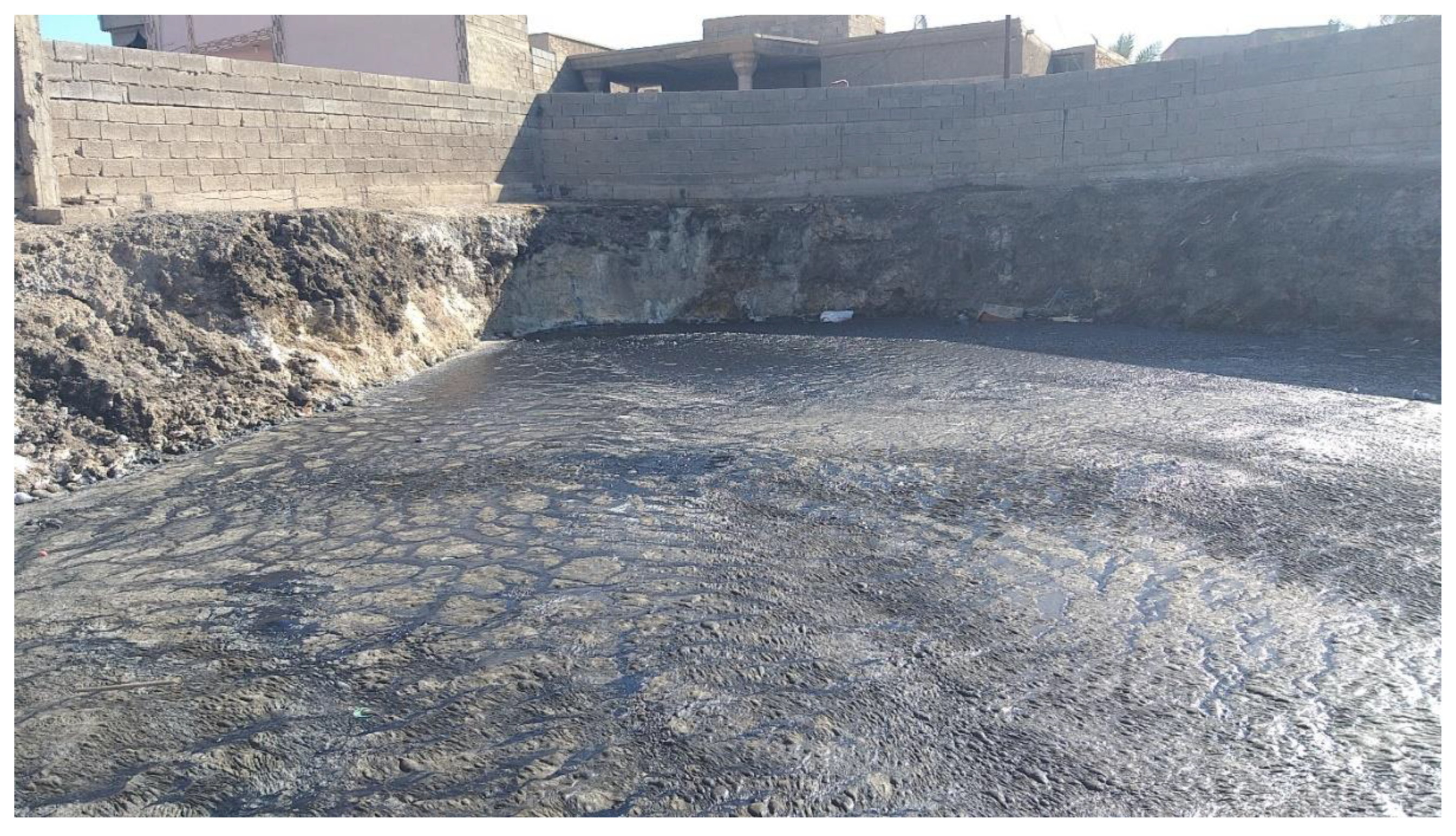

Table 1.
Water chemistry data for the Abu Jir springs (medians: bold, ranges, number of samples: italics) and rainfall at Riyadh (precipitation-weighted mean). All values mg/L unless indicated otherwise. See Figure 1 for spring locations. Saturation indices with respect to calcite were calculated using Equations 1 and 2.
| Location | T°C | pH | EC µS/cm | Ca | Mg | Na | K | Cl | SO4 | HCO3 | NO3 | SI calcite |
|---|---|---|---|---|---|---|---|---|---|---|---|---|
| Haqlaniyah [8,50] |
29 29-29 3[8] |
7.2 7.1-7.3 3 |
5068 5038-5523 3 |
312 288-320 3 |
144 134-146 3 |
251 230-709 7 |
22 21-94 3 |
1620 643-1925 7 |
674 403-1260 7 |
265 223-270 3 |
3 2-3 3 |
0.46 0.29 - 0.5 3 |
| Hit-Kubaysa [8,10,12,29,50] |
27 16-34 49 |
7.2 6.0-7.8 48 |
7100 1800-35418 23 |
400 225-1783 21 |
210 94-607 21 |
619 200-6876 27 |
85 5-540 21 |
1488 320-16100 45 |
480 91-3120 45 |
197 85-1380 21 |
7 2-10 8 |
0.31 -1.54 - 2.1 21 |
| Najaf [9,11,50] |
25 23-27 20 |
7.2 6.9-7.8 20 |
2360 1820-3200 20 |
188 112-326 10 |
185 46-342 10 |
271 203-457 13 |
54 41-74 9 |
588 350-2591 13 |
785 538-1765 13 |
116 45-140 9 |
-0.19 -1.11 - 0.69 9 |
|
| Shinafiyah [63] |
7.7 7.0-8.0 12 |
4815 4010-6080 12 |
391 346-496 12 |
242 160-294 12 |
817 690-1094 12 |
2610 1330-2861 12 |
178 121-211 12 |
0.77 -0.18 - 1.15 12 |
||||
| Riyadh rainfall [47] |
32 | 2 | 6 | 2 | 10 | 17 |
Disclaimer/Publisher’s Note: The statements, opinions and data contained in all publications are solely those of the individual author(s) and contributor(s) and not of MDPI and/or the editor(s). MDPI and/or the editor(s) disclaim responsibility for any injury to people or property resulting from any ideas, methods, instructions or products referred to in the content. |
© 2024 by the authors. Licensee MDPI, Basel, Switzerland. This article is an open access article distributed under the terms and conditions of the Creative Commons Attribution (CC BY) license (http://creativecommons.org/licenses/by/4.0/).
Copyright: This open access article is published under a Creative Commons CC BY 4.0 license, which permit the free download, distribution, and reuse, provided that the author and preprint are cited in any reuse.


