
Submitted:
28 July 2024
Posted:
30 July 2024
You are already at the latest version
Abstract
The Kampar Peninsula, a significant peatland region in Riau, Indonesia, is vital for its carbon re-serves and biodiversity, including the Sumatran tiger. Covering approximately 735,091 hectares, it comprises critical peat domes essential for hydrological balance. This research investigates land use changes from 1990-2020 using the Normalized Difference Fraction Index (NDFI) to map disturb-ances and land cover changes. Additionally, interviews and regulatory analysis were conducted to examine the historical drivers of land use change in the Kampar Peninsula. In 2020, natural forests covered 433,395.20 hectares (59.9% of the total area), industrial pulpwood plantations (primarily acacia) covered 27.3%, oil palm plantations accounted for 10.4%, infrastructure occupied 2.4%, and water bodies made up 0.9%. Key drivers of land use change include the construction of access roads by oil companies since 1975 and government policies during the New Order period (1980s-1998) promoting forest exploitation and transmigration programs. These activities have significantly transformed the Kampar Peninsula's land cover, highlighting the need for sustainable management and conservation efforts.
Keywords:
Kampar Peninsula
; Peatland
; NDFI
; Spatial Analysis
; Riau Province
1. Introduction
Tropical forests and peatlands play a crucial role in providing ecosystem services to global, regional, and local communities, as well as to biodiversity [1]. Tropical peatland ecosystems offer a range of ecosystem services, such as carbon storage, water regulation, food production, and disaster mitigation [2,3,4]. The unique characteristics of natural peatland ecosystems, with their wet habitats that are difficult to access and nearly uninhabitable by humans, make them vital habitats for various endangered species. The ecological importance of peatland ecosystems includes maintaining water system stability, storing carbon, and serving as biodiversity habitats [5,6].
Peatlands are spread across 175 countries, covering 3% of the earth’s land area, or about 400 million hectares, with approximately 11% or 42 million hectares being tropical peatlands [7]. Southeast Asia has the largest expanse of tropical peatlands, particularly in Borneo, Sumatra, and Peninsular Malaysia, known for over 300 years [8,9]. Southeast Asia’s tropical peatlands cover 24.8 million hectares, representing about 56.6% of the global tropical peatland area (44.1 million hectares) and approximately 6% of the total global peatland area [9]. It was largely undeveloped until the 1980s due to challenging working conditions for heavy machinery, low agricultural potential, and sufficient availability of land on mineral soils. However, since the 1980s, the peatlands of insular Southeast Asia have been increasingly utilized [10], causing significant ecological, hydrological, and atmospheric effects.
Indonesia’s peatlands span 13.4 million hectares, accounting for 80% of Southeast Asia’s peatlands and 50% of the world’s tropical peatlands [11]. This makes Indonesia the largest owner of tropical peatlands globally and the fourth largest overall after Canada (170 million hectares), Russia (150 million hectares), and the United States (40 million hectares). Despite the extensive coverage of peatlands, the world has witnessed significant forest loss in recent years. Between 2000 and 2012, global forest loss increased by approximately 2000 km2; per year [12]. Deforestation contributed to around 8% of anthropogenic carbon emissions in the 2000s [13], and despite forests remaining a carbon sink, emissions from degradation were 0.80 Gt CO₂ per year between 1990 and 2015 [14].
Sumatra, with an area of approximately 470,000 km2;, is Indonesia’s largest island and the world’s sixth largest, supporting a population of 40 million people. The lowland forests cover around 118,300 km2; of the eastern part of the island. These rainforests are characterized by large, buttressed trees, predominantly from the Dipterocarpaceae family, along with woody climbers and epiphytes. Figs are also common in these lowland forests, with more than 100 fig species found in Sumatra. According to SPOT Vegetation data from 2006, Sumatra’s peat swamp forests cover approximately 33,600 km2;. Located on the island’s eastern coast, these forests contain the deepest peat in Indonesia. Over 30 percent of Sumatra’s peat exceeds 4 meters in depth, with the majority found in the Sumatran province of Riau, where peatlands account for 56.1 percent of the total provincial area. Sumatra’s lowland forests are home to a diverse range of species, including the Sumatran pine, Rafflesia arnoldii (the world’s largest individual flower, measuring up to 1 meter wide), and Amorphophallus species (featuring the world’s tallest and largest inflorescence, reaching up to 2 meters tall). The island is also home to the Sumatran tiger, orangutan, Sumatran rhinoceros, Sumatran elephant, Malayan tapir, Malayan sun bear, Bornean clouded leopard, and a variety of birds and butterflies.
Between 2007 and 2015, the rate of peat forest loss was 2.6% per year in Sumatra and Kalimantan [15]. The growing demand for arable land, particularly for palm oil production, along with the suitability of peatlands’ flat topography, has led to intense conversion and drainage. About half of the peatlands in Sumatra and Kalimantan are used for smallholder agriculture and industrial plantations, with oil palm accounting for 64% of industrial plantation areas and pulpwood (Acacia) plantations, primarily located in Sumatra, making up the rest [16].
Pelalawan and Siak Regencies are the parts of Kampar Peninsula, a significant peatland region in Riau. [18] reports that this area covers about 735,091 hectares of peatland, constituting roughly 18.16% of Riau Province’s total area. The Kampar Peninsula includes two central peat domes, with depths reaching up to 16 meters. These domes are crucial to the area’s hydrological system, functioning as natural water reservoirs and regulators. This region is home to four protected areas, consisting of three Wildlife Reserves (Tasik Belat, Tasik Metas, and Tasik Serkap) covering 13,936 hectares and Zamrud National Park covering 31,643 hectares (Figure 1). Additionally, the region includes a peat ecosystem restoration concession of 130,095 hectares. The ratio of natural forest to non-forest area is approximately 1:2.5. This peat swamp forest is a crucial habitat for the Sumatran tiger, with female tigers’ home ranges spanning 50-70 km2; and males’ 100 km2;, though in low-density habitats, this can extend up to 289 km2;. It is estimated that about 13 Sumatran tigers inhabit the Kampar Peninsula.
In Riau Province, nearly half of the 4 million hectares of peat swamp is already deforested, drained, decomposing, or burning. Large areas of Riau’s peat swamps have been cleared and drained for settlements and large-scale development projects. [17] recorded the number of fire hotspots in various regencies of Riau Province, highlighting the regions most affected by forest fires. The data, modified from the National Disaster Management Agency in 2018, showed that Bengkalis and Pelalawan regencies have consistently experienced the highest number of hotspots, ranging from 400 to 900 each year. Specifically, in 2011, Bengkalis recorded 854 hotspots, while Pelalawan had 460. This trend continued with high numbers in subsequent years, peaking in 2014 when Bengkalis recorded 825 hotspots and Pelalawan 617.
Vegetation trend analysis is a straightforward yet effective method for analyzing vegetation dynamics, including greenness trends and gradual changes. [19] examined vegetation greenness trends using all available Landsat 5, 7, and 8 images acquired between 1999 and 2014, employing a slope coefficient for analysis. Similarly, [20] used NDVI (MODIS) to identify gradual changes in forest cover by applying linear regression, identifying forest degradation through significant negative trends (p-value). The Normalized Difference Fraction Index (NDFI), calculated using the fractions of green vegetation (GV), non-photosynthetic vegetation (NPV), soil (So), and shade (Sh), is a fraction index derived from Spectral Mixture Analysis (SMA) [20,21].
The study and monitoring of land use changes in Riau have been intensifying over the years. [22] employed a combination of Global Forest Change (GFC) data and ClasLite software with conventional supervised classification algorithms to analyze 30-meter spatial resolution Landsat imagery in Riau, Indonesia. [23] utilized MODIS (Moderate Resolution Imaging Spectroradiometer) data from the Terra and Aqua satellites to study land use changes between 1990 and 2017. The MODIS instrument, with its 1 km2; spatial resolution at nadir, enabled the detection of fire occurrences. The researchers specifically used the MCD14ML Global Monthly Fire Location Product Collection 6, which can detect fires as small as approximately 50 m2; under optimal conditions. This study highlighted the extensive fire events in Riau and their implications for land use and forest management. [24] conducted a landscape-level assessment using Landsat TM data to focus on general land-cover types and changes over time. Meanwhile, [25] utilized SPOT 1, 2, and 4 satellite image data, which were received and preprocessed to level 2A by the Centre for Remote Imaging, Sensing, and Processing (CRISP) in Singapore. The high-resolution SPOT imagery offered a detailed view of land cover and facilitated the monitoring of land use changes with greater accuracy
Despite these advancements of vegegation trend analysis, a significant research gap remains: current monitoring methods have not yet integrated the NDFI into their analyses. The NDFI is a new spectral index designed to enhance the ability to detect canopy damage caused by selective logging and forest fires. This index combines spectral and spatial information to map canopy damage more effectively. It is particularly useful for distinguishing between undisturbed forests, canopy gaps, open land, and dead vegetation, which can result from selective logging, forest fires, and forest fragmentation, where tree loss does not always completely alter the land cover type [26]. To enhance the understanding of land use changes, this study integrates NDFI with a qualitative analysis of historical regulations and policies that have influenced land use decisions during the study period (1990-2020). The novelty of this research lies in its innovative integration of NDFI with a qualitative analysis of historical regulations, offering a comprehensive and detailed approach to understanding land use changes in the Kampar Peninsula.
Building on this foundation, this research aims to detect forest cover changes using the NDFI and analyze the driving factors behind land use changes, focusing on the conversion of natural forest cover to non-forest areas in the Kampar Peninsula over a 30-year period from 1990 to 2020. This study will employ quantitative spatial analysis of Landsat imagery from 1990-2020 based on the Spectral Mixture Analysis (SMA) model to detect and classify forest disturbances. Ground truthing will be conducted to validate the image interpretation results by comparing them with actual field conditions. Additionally, a qualitative analysis will be carried out to study the trends in spatial changes in the Kampar Peninsula, understand the context of these changes, and analyze the factors driving them.
2. Materials and Methods
This research was carried out in the peat ecosystem of the Kampar Peninsula, which administratively belongs to Pelalawan Regency and Siak Regency in Riau Province (Figure 2). The Kampar Peninsula covers an area of approximately 735,091 hectares within the Siak River-Kampar River Peat Hydrological Unit. The climate in this region falls under category A (very wet) based on the Schmidt-Ferguson classification, with an average annual rainfall of 2,100 mm. In the central part of the Kampar Peninsula, there are two significant peat domes. These peat domes play a crucial role in the hydrological system of the region, with the deepest peat layers exceeding 16 meters. The Kampar Peninsula is also home to several lakes, known locally as tasik. These lakes give rise to various rivers, some of which flow northward into the Selat Panjang (such as the Rawa River, Belat River, and Metas River), while others flow southward into the Kampar River (such as the Kutup River, Turip River, Serkap River, and Sangar River). As of 2022, the population of the Kampar Peninsula landscape totals 40,554 people, with 10,766 residing in Siak Regency and 29,788 in Pelalawan Regency.
2.1. Data Collection
The data collection for this research involved both quantitative and qualitative approach to ensure a comprehensive analysis. For quantitative analysis, the Landsat imagery data was collected over a 30-year period from 1990 to 2020, comprising a total of 2,175 images. These images were meticulously selected for their spatial and temporal coverage to effectively capture land use changes over time. The data was processed at a high resolution of 30 meters by 30 meters, covering a total of approximately 735,091 hectares (equivalent to 8,167,678 cells). The Coordinate Reference System (CRS) used for this analysis was EPSG: 4326. Land and forest cover data were derived from the NDFI based on Landsat 4-5-7-8 images for the years 1995, 2000, 2010, 2015, and 2020. This data was analyzed using the Spectral Mixture Analysis (SMA) method to detect forest disturbances and classify land cover [27,28]. The analysis was performed using Google Earth Engine (GEE) and JavaScript functions [29].
In addition to quantitative data, qualitative data were gathered through in-depth interviews with various stakeholders involved in land use policy in the Kampar Peninsula. These interviews, conducted with community leaders, government officials, and NGO representatives, utilized structured interview guides and a comprehensive list of questions. The focus was on understanding government policies, which are defined as actions or decisions taken by the government to address societal issues. The qualitative analysis of these interviews provided valuable insights into the influence of government policies on land use decisions and changes in the Kampar Peninsula. This qualitative data will complement the understanding of the policy-related drivers contributing to land cover changes, which were quantitatively recorded through NDFI analysis.
2.2. Data Analysis
For quantitative data analysis involved a systematic process that includes selecting appropriate imagery, pre-processing the data, and selecting specific bands for analysis. This process is executed using a sequence of JavaScript functions within the Google Earth Engine platform. The main function, getLandsat(), is used to retrieve the necessary Landsat images. This function works in conjunction with various other functions in the ccdcUtilities/api, which together handle a total of 19 bands [30,31].
For selecting and processing Landsat imagery from satellites 4, 5, 7, and 8, the workflow involves several steps that leverage cloud data and computing resources available through the open-source application Google Earth Engine using JavaScript. The data processing begins with the use of cloud data to access available Landsat images. These images are then organized into an image stack by the cloud engine. Specific years are selected for analysis, and the NDFI is calculated for these years to detect natural forest disturbances over time [32,33]. The cloud engine classifies areas into natural and non-natural forest categories and further classifies natural forest disturbances. The detection of these disturbances is performed by comparing NDFI values between different years. Subsequently, the cloud engine estimates land use changes over the selected years. Ground truth data is used to validate these changes and identify different land use types. Finally, the cloud engine classifies and estimates the land use types. This process is illustrated in Figure 3.
After the completion of data processing, the quantitative analysis proceeded through several stages. Initially, forest disturbances were identified and land cover was categorized into natural forest and non-natural forest cover, with an estimation of the area of change for different observation periods. The classification analysis utilized NDFI detection changes calculated in 12 time groups using Google Earth Engine (GEE) employing a Random Forest (RF) algorithm and referenced to ESA WorldCover at a 10-meter resolution. The Coordinate Reference System (CRS) used was EPSG: 4326, with a cell resolution of 30 meters.
Subsequently, land cover change maps were identified for specific periods, including 1990-1993, 1998-2000, 2000-2003, 2008-2010, 2010-2013, and 2018-2020. The identification process integrated NDFI detection change maps and ground check coordinate data. Visual inspection methods were applied to these maps, and the accuracy was validated through ground checks. Ground check data were obtained from two sources: the first source was a collection of field observation results during surveys conducted from 2017 to 2021 with the field team, and the second source was visual observations based on GEE satellite imagery from 2021. Ground check data from field observations were collected using a Garmin 78S handheld device, recording points, track routes, and significant locations related to the historical dynamics of land use change in the Kampar Peninsula. The distribution of these observations is illustrated on the map in Figure 4. Key landmarks considered important by the author and still present today include oil wells that have been operational for five decades, an oil road constructed around 1982, the Benteng Ulu dock on the banks of the Siak River in the village of Mempura, where Sultan Siak II, who ruled from 1746-1765 AD, is buried, the Dutch fort built in 1827 AD, the Local Transmigration Village of Sawit initiated around 1985, Dayun Village, the old Buton Port, Pangkalan Kerinci City, Teluk Lanus Village, the Serkap River area, and Serapung Village.
The identification process was divided into four clusters to differentiate the impacts of various land use types. Cluster A includes industrial infrastructure (e.g., oil and gas facilities, Industrial Forest Plantations/HTI for pulp and paper) to monitor significant industrial activities separately. Cluster B covers residential buildings to analyze urban expansion and settlement impacts distinctly. Cluster C focuses on oil palm plantations due to their rapid expansion and associated environmental concerns, while Cluster D encompasses acacia industrial forest plantations to understand the dynamics of industrial forestry practices. Visualizations for these four clusters are presented in Figure 5.
In conducting the qualitative analysis, the data processing involved examining interview results relating to the drivers of land use change, government policies, and sustainable peatland ecosystem management. The interview data processing began with transcription, creating comprehensive written descriptions of the interviews, including verbatim recording of any statements made in local languages. This qualitative data provided valuable insights into the factors driving land use changes, complementing the quantitative findings.
2.2.1. Analysis of Forest Disturbance Detection and Classification
This analysis utilized a dataset comprising 2,175 Landsat images, each with 19 bands, covering the period from 1990 to 2020, along with the application of Google Earth Engine (GEE) [30,34,35]. The data was analyzed using the Spectral Mixture Analysis (SMA) method. The SMA theory assumes that each image pixel is composed of various proportions of endmembers (spectral signatures) with pure spectral fraction values [36]. This method determines the component parts of a mixed pixel by predicting the proportion of the pixel that belongs to specific classes or features based on the spectral characteristics of its endmembers. For example, the endmembers of Green Vegetation (GV) might have a spectral fraction composition of [0.0119, 0.0475, 0.0169, 0.625, 0.2399, 0.0675] across the blue, green, red, NIR, SWIR1, and SWIR2 bands, respectively (Bullock, Woodcock & Olofsson, 2020). The procedure for calculating each NDFI began by selecting six bands [BLUE, GREEN, RED, NIR, SWIR1, SWIR2] from the Landsat dataset (Table 1).
The data from these six bands at the initial time point (time0) were used to identify spectral signatures [GV (Green Vegetation), Soil, NPV (Non-Photosynthetic Vegetation), Shade, Cloud] (Table 1) for each cell of these bands through the process of spectral unmixing. This unmixing was performed using the unmix() function or the getSMAFractions() function. This process created five new bands representing the different spectral signatures, allowing for a detailed analysis of forest disturbances and land cover changes. Using the identified spectral signatures, the analysis was conducted over 12 observation time groups specified in Table 2, which detail the ranges for time0 and time1. These periods span from 1990 to 2020, enabling the study to effectively track and analyze changes in forest cover and disturbances over three decades.
2.2.1. Identification of Land Use Cover Change
Natural forest and non-forest areas were performed to calculate changes in land use area over the observation periods. The data from the forest disturbance detection analysis (using NDFI) from the previous process was used as a variable. At this stage, the 12 NDFI observation time groups (Table 2) were consolidated into 6 observation time groups for natural forest and non-forest areas (Forest-Non Forest/FNF) (Table 3). This analysis employed the Random Forest (RF) algorithm, using a sample dataset of 500 randomly stratified points per classification category. For the training process, 80% of the samples were used for training, and the remaining 20% for validation. With 1,000 trees in the trained classifier, an Overall Accuracy (OA) of 98.17% was achieved.
This classification referenced the European Space Agency (ESA) WorldCover 10 m v.100, utilizing three category classes: tree cover (canopy cover), built-up (infrastructure such as buildings and roads), and open water (https://developers.google.com/earth-engine/datasets/catalog/ESA_WorldCover_v100). The analysis was conducted using Cloud Data and the Google Earth Engine (GEE) open-source application.
3. Results
Approximately five decades ago, before 1975, the peat ecosystem of the Kampar Peninsula was entirely natural forest. The wet habitat of the peat swamp forest was impenetrable and untouched by development activities. The first significant disturbance occurred in the protected area of the Danau Pulau Besar and Danau Bawah Wildlife Reserve, covering 28,000 hectares, where 3,400 hectares were cleared for oil exploration and production at the Zamrud field. The oil reserves at Zamrud field were discovered in 1975 beneath these two lakes at a depth of 3,000 feet and began production in 1982. Between 1979 and 1982, the roads were built by the oil company connected Dayun Village, located near the Zamrud oil field, with surrounding villages such as Benteng Ulu Village on the banks of the Siak River (near the historical Dutch fort built in 1827), Teluk Mesjid Village, and the old Buton Port on the edge of Selat Panjang. Since then, the process of land use change in the Kampar Peninsula peatlands has continued to the present day.
Currently, the peat forest cover of the Kampar Peninsula consists not only of natural forests but also industrial forest plantations (Acacia), oil palm plantations, rubber plantations, residential areas, community agricultural lands, and areas developed for infrastructure. The ratio of natural forest to non-forest areas has reversed compared to several decades ago.
3.1. Detection of Forest Disturbances and Classification of Land Cover Using NDFI
The detection of forest disturbances using the NDFI is shown in Figure 6. It presents the result of the detection and classification of forest cover changes through continuous monitoring of forest disturbance events using a dataset of 2,175 continuous Landsat images over the observation period from 1990 to 2020. The detection and classification analysis utilized the Spectral Mixture Analysis (SMA) model to calculate the fractional composition (NDFI) of five endmembers (spectral signatures) (GV, NPV, Soil, Shade, Cloud) for each cell in the continuous Landsat image data.
Forest disturbance events in tropical forests should be monitored every 2-3 years to account for natural forest succession processes. In this study, monitoring in the Kampar Peninsula was conducted across 12 observation time groups, considering cloud cover and image quality. Based on the calculation of NDFItime0 - NDFItime1 for these observation periods, the monitored forest disturbance events were then classified into five classes, representing the chronology of forest disturbance events occurring during and before the monitoring period. The five classification classes are as follows:
- Class 1: Undisturbed old-growth forest or remnants of previous disturbances that have not undergone further disturbance or regrowth (no change between years, white);
- Class 2: Natural forest that has not experienced disturbance or has fully recovered (natural forest, green);
- Class 3: Forest disturbances due to fire and/or selective logging (forest disturbance, orange);
- Class 4: New forest disturbances or ongoing disturbances (new disturbance, light red);
- Class 5: Old forest disturbances or remnants of previous disturbances that have regrown (old disturbance, light blue).
Figure 6 consists of two maps. Map (a) displays a classification of five classes resulting from the calculation of NDFItime0-NDFItime1 during the observation period. Map (b) is a true color RGB map, covering the same observation period as map (a) and visually confirms the forest disturbance events classified in map (a), particularly showing events that occurred before the initial time0 observation period. The maps visually display the traces of forest disturbance events that occurred before the observation period of map (a), ranging from light gray to dark gray.
Based on Figure 6, the 2020 data was further developed into a map overlay to show the land use classification map of the Kampar Peninsula (Figure 7). This classification reveals the distribution and extent of various land cover types across the region. The area and percentage of each land cover class are summarized in Table 4.
In 2020, natural forests occupy the largest portion of the Kampar Peninsula, covering 433,395.20 hectares, which constitutes 59.9% of the total land area, which has either not experienced disturbance or has fully recovered, depicted in green. Industrial pulpwood plantations, primarily consisting of acacia, cover 27.3% of the area, shown in purple. Plantations, mainly oil palm, account for 10.4% and are marked in. Infrastructure, including roads and buildings, makes up 2.4% of the land area, indicated in grey. Water bodies, such as rivers and lakes, occupy 0.9% of the region, depicted in blue.
3.2. Land Use Change Analysis: Natural Forest and Non-Forest Areas
The data from the forest disturbance detection analysis using NDFI were further grouped into six observation time groups, as presented in Table 5 and Figure 8. This analysis illustrates the change in land use from natural forest cover to non-forest cover (Forest-Non Forest/FNF).
Table 5 and Figure 8 indicate that over 30 years, the natural forest area in the Kampar Peninsula decreased significantly from 723,895.30 hectares in 1990 to 433,395.20 hectares in 2020. In 1990, the Kampar Peninsula had 723,895.30 hectares of natural forest and only 4,292.40 hectares of non-natural forest. By 1995, natural forest cover decreased to 646,695.18 hectares while non-natural forest areas increased significantly to 81,492.50 hectares, indicating early signs of land use change due to agricultural expansion and logging. In 2000, natural forest cover slightly decreased to 641,112.03 hectares, with non-natural forest areas rising to 87,075.65 hectares, reflecting ongoing land conversion. By 2005, natural forest cover dropped substantially to 441,519.66 hectares, and non-natural forest areas surged to 286,668.02 hectares, marking intensified deforestation and land conversion activities. In 2010, natural forest cover further decreased to 367,125.84 hectares, nearly matching the 361,061.84 hectares of non-natural forest, highlighting extensive landscape transformation. A slight recovery occurred in 2015, with natural forest cover increasing to 437,866.23 hectares and non-natural forest areas decreasing to 290,321.45 hectares, possibly due to reforestation efforts. By 2020, natural forest cover stabilized at 433,395.20 hectares, with non-natural forest areas at 294,792.48 hectares, indicating continued significant land use changes. Over the three decades, there was a consistent decline in natural forests and a rise in non-forest areas, driven by agricultural and industrial activities.
The comparison of land use changes is illustrated in Figure 9, which juxtaposes imagery data from the periods 1990-1995 and 2016-2020. This comparison highlights the significant transformations in land cover over these decades.
As shown in Figure 9, the remaining natural forest areas are located in the central part of the Kampar Peninsula, where the peat dome is situated. Naturally, this area is difficult to access, which is beneficial since the peat dome is crucial for the integrity of the peatland ecosystem. The presence of industrial forest plantations on the outskirts of the natural forest area also helps restrict access to the central part of the Kampar Peninsula.
4. Discussion
Our quantitative approach using NDFI analysis reveals significant shifts in land cover driven by various socio-economic and environmental factors. The changes in forest cover in the Kampar Peninsula have been ongoing since the region was still an intact tropical peat swamp forest. These land cover changes have been occurring since the era of the Sultanate of Siak, along the banks of the Siak River, and continue to the present day. The identified driving factors behind these land cover and land use changes in the Kampar Peninsula are detailed in the following discussion.
4.1. Historical Land Use Changes in Kampar Peninsula
4.1.1. Pre-1990 Period
Prior to 1990, land cover changes in the Kampar Peninsula were influenced by two main periods: the era of the Siak Sultanate and the New Order government. In Figure 9a, representing the period from 1990-1995, the Kampar Peninsula was predominantly covered by natural forest, especially in the central and eastern regions. The western side, however, shows the early stages of deforestation and land conversion activities. This area is primarily near old settlements, connected by river access and subsequently built roads, such as between Dayun Village near the Zamrud area and Buton Port, as well as the historical settlements of the Siak Sultanate along the Siak River and Pangkalan Kerinci Village, which later became the capital of the regency with Pekanbaru City.
During the Siak Sultanate era, land cover changes occurred primarily along the Siak River, near the Sultanate’s capital, Siak Sri Indrapura. NDFI detection from 1990-1993 shows historical land cover changes around Mempura Village, near the mouth of the Mempura River (Figure 10). Key landmarks from this era include the tomb of the second Sultan of Siak (1746-1765) and a Dutch fort built in 1827. The Mempura River was a vital access route to the interior via the Dayun River, leading to the Tasik Zamrud forest. The Benteng Ulu ferry dock in Mempura was used by locals to cross the Siak River before the Siak bridge was built. In the period from 1990-1995, the early stages of deforestation and land conversion in the western side of the Kampar Peninsula are evident. This early deforestation is linked to historical settlements and the development of infrastructure connecting these areas. For instance, roads were built to connect settlements like Dayun Village and Buton Port, facilitating access and further land conversion. The influence of the Siak Sultanate is also visible, with land cover changes occurring along significant historical routes, such as the Siak River and the Mempura River.
During the New Order government (1965-1998), significant land cover changes began in the Kampar Peninsula, particularly in the Danau Besar and Danau Bawah Wildlife Reserve (now Zamrud National Park since 2016), driven by oil exploration and production activities starting in the early 1970s. The establishment of the Zamrud oil field, notably the Idris Oil Well, marked the beginning of these changes. The construction of roads between 1975-1982, which connected Dayun Village to the Benteng Ulu dock in Mempura, played a crucial role in facilitating access and stimulating economic activities in Dayun and its surrounding areas (Figure 11).
Richard H. Hopper, in his book, notes that in May 1973, Caltex recorded a peak production of 1 million barrels per day. Since production began in the early 1950s, the oil fields in Riau, managed by PT CPI, had contributed over 12 billion barrels to national production cumulatively, with a significant portion coming from the giant Minas oil field. This massive production output underscores the scale of resource extraction activities during the New Order era and their impact on the region’s land cover.
The development of roads to accommodate oil exploration significantly influenced land use changes during this period. The newly constructed infrastructure facilitated the transportation of resources and personnel, thus accelerating deforestation and the conversion of natural forests into non-forest land uses. These roads provided vital access routes, enabling the expansion of agricultural and industrial activities, further driving land cover changes. The roads built to support oil exploration not only provided access to previously inaccessible areas but also encouraged further development and exploitation of natural resources. This infrastructure development was a critical factor in transforming the landscape of the Kampar Peninsula. The improved connectivity allowed for the more efficient extraction of oil, which in turn boosted economic activities and job opportunities in the region. However, this also resulted in significant environmental impacts, including extensive deforestation and habitat fragmentation.
4.1.2. Period of 1990 – 2000
Following the initial developments in the Danau Besar and Danau Bawah Wildlife Reserve, the subsequent phase of land cover changes was observed in the Local Transmigration (Translok) areas, where oil palm plantations were established around 1985 near Dayun Village and Pangkalan Kerinci.
One notable area, Kampung Sawit Permai, was formed in 1991 as a result of administrative decisions. This settlement emerged from the provincial and national policies aimed at developing transmigration units. According to the Bengkalis Regency Head’s letter dated December 12, 1990, and the Riau Governor’s Decree No. KPTS: 305/VI/1991, these areas were officially recognized. The Ministry of Home Affairs facilitated the handover of transmigration settlement units to the Riau Governor as per document No. 475.1/669/SJ.
Figure 12 illustrates these changes, with locations a1 and a2 indicating the expansion of transmigrant settlements. Residents in these areas primarily planted oil palm as their livelihood, marking a significant shift from natural forest cover to agricultural land use. The establishment of these settlements and plantations facilitated economic activities and provided job opportunities, further driving land cover changes.
In locations b1 and b2 in Pangkalan Kerinci, land cover changes are associated with the pulp and paper industry. The early 1990s saw the establishment of acacia industrial plantations, factory construction, employee housing, and supporting facilities. PT Riau Andalan Pulp and Paper (RAPP) began operations in 1993, initially processing natural forest wood and later using acacia wood from industrial plantations in the Kampar Peninsula and other areas as raw materials. The strategic location of Pangkalan Kerinci, with road access connecting it to Pekanbaru, the capital of Riau Province, further facilitated these industrial activities.
4.1.3. Period of 2001 – 2020
The NDFI change detection from 2000-2003 reveals further land cover changes in Pelalawan Regency, which had recently been separated from Kampar Regency. The separation was based on the Indonesian Law No. 53 of 1999. Initially, Pelalawan Regency comprised four districts: Langgam, Pangkalan Kuras, Bunut, and Kuala Kampar. The official inauguration was conducted by the Minister of Home Affairs on October 12, 1999. Pelalawan Regency covers an area of 13,924.94 km2;, mostly consisting of mainland and some islands. The capital of Pelalawan Regency is Pangkalan Kerinci. Over the ten-year period from 2008 to 2017, the total area of oil palm plantations in Pelalawan Regency exhibited a steady increase. In 2008 the area of oil palm plantations is at approximately 304,927 hectares. The findings of Rusmanto et al. (2023) indicate that the expansion of oil palm plantations in Pelalawan can have a positive impact on improving the economic conditions of the community and accelerating regional development. However, uncontrolled expansion of oil palm plantations can also have negative consequences, including the potential for conflicts that may lead to violent disputes between oil palm plantation companies and local communities, as well as among the communities themselves. (Figure 13).
The expansion of oil palm plantations and acacia HTI continued, peaking around 2010 when the Indonesian government implemented a moratorium on the conversion of natural forests and peatlands. The Government of Indonesia announced a two-year moratorium on the conversion of natural forests and peatlands starting in 2011. Under this moratorium, no new conversion permits would be issued, although permits issued before 2011 would not be affected. This moratorium was part of the measures taken under the US$1 billion partnership agreement between Norway and Indonesia, aimed at reducing emissions from deforestation and forest degradation, conserving and sustainably managing forests, and enhancing carbon stocks (REDD+). As of 2011, mining, agriculture, and plantation operations were only permitted in degraded forests or idle lands, but industrial forest estates and forestry concessions were not affected.
4.2. Analysis of Key Drivers of Land Cover Change in the Kampar Peninsula
The overall analysis of natural forest disturbance traces or changes recorded in each continuous Landsat image cell indicates that land cover changes in the Kampar Peninsula initially began on the western side of the Kampar Peninsula landscape. These changes were particularly prominent in areas close to old settlement centers, connected by river access and subsequently constructed roads. Notable examples include the area between Dayun Village near the Zamrud region and Buton Port, along with historical settlements from the era of the Siak Sultanate along the banks of the Siak River, and Pangkalan Kerinci Village, which later became the capital of the regency with Pekanbaru City.
The research findings presented indicate two primary factors driving land use change in the Kampar Peninsula peat swamp forests. The first factor is the introduction of vehicular access roads into previously inaccessible wetland habitats. The intensity of forest disturbances varied significantly between areas with road access and those without. For example, regions such as Teluk Lanus Village in the northeastern Kampar Peninsula and the Serkap area in the southeastern Kampar Peninsula, which lack road connectivity, experienced less intense forest disturbances. In contrast, disturbances were more pronounced along the edges of water bodies like the coast of Selat Panjang and the Kampar River towards the east, especially around the central peat dome of the Kampar Peninsula..
Allan et al. (2021) [41] highlighted that urban growth contributes to changing the spatial structure and land use/land cover (LULC) of urban areas, driven by factors such as transportation infrastructure, accessibility, and industrial development. This is particularly relevant as the industrial sector, unlike agriculture, has a higher potential for inducing environmental, regional, and national changes. The introduction of roads not only facilitates transportation but also acts as a catalyst for industrial and agricultural expansion, leading to significant land cover changes. Furthermore, research by [37], identified logging roads as a major factor in deforestation and peatland forest degradation, subsequently driving land use change. The results are also be compared with findings from the [38] study which assessed land-cover changes in peatlands from 1992 to 2020 in Jambi, Indonesia. The result showed a decrease in forests and wetlands alongside an increase in agriculture, grassland, and built-up areas. This trend highlights the widespread nature of land-cover changes across different peatland regions in Sumatra, driven by similar factors such as agricultural expansion and infrastructural development. However, in the Kampar Peninsula, it was oil companies, rather than logging companies, that initially constructed access roads around 1975. These roads broke the region’s isolation and connected various locations, starting with Buton Lama Port, enabling human movement into the western interior of the Kampar Peninsula and fostering social and economic growth.
The second driving factor behind natural forest cover changes and land use transformation in the Kampar Peninsula is government policy. During the New Order era, from the 1980s to 1998, the Indonesian government issued regulations for the management of production forests. During this period, concession permits for forest exploitation (HPH) were granted in the Kampar Peninsula, alongside transmigration programs that were coupled with the development of oil palm plantations. Permits for oil palm plantations were also issued independently of the transmigration programs. In the 1990s, the government issued permits for industrial forest plantations to supply raw materials for the pulp and paper industry.
A significant reduction in natural forest area occurred from the early 2000s to the 2010s. Investigations into permit issuance, government regulations, and interviews with representatives from the Ministry of Environment and Forestry (KLHK) suggest that during this period, there was likely a substantial issuance of Industrial Forest Plantation (HTI) permits and oil palm plantation permits. The trend shows a decrease in the rate of natural forest conversion to non-forest areas around 2012-2015. This decrease is believed to be related to the issuance of a Presidential Regulation (Perpres) of the Republic of Indonesia on a moratorium, which halted new concession permits in primary natural forests or peatlands in May 2011. Additionally, in 2012, the government began issuing Ecosystem Restoration permits, which were exempt from the moratorium, in the Kampar Peninsula. These conservation and restoration efforts of the peatland natural forest appear to have had positive results.
Extending the plantation moratorium to include secondary forests as well as primary forests would also help reduce the conversion of natural forests and reduce the frequency of fires. Reducing the susceptibility of the landscape to fire, through restoring, rewetting, and revegetating degraded shrublands, particularly on peatlands, is a priority. Since 2016, the Indonesian government has enacted a policy to restore degraded peatland in seven priority provinces, including West Kalimantan, with a total protected area of 28,136 ha, permitted cultivation area of 64,078 ha, and non-permitted area of 27,239 ha. In Riau province, the total targeted area for restoration is 815,180 ha, with a protected area of 43,810 ha, permitted cultivation area of 707,836 ha, and non-permitted cultivated area of 43,810 ha. Areas for pulpwood (Acacia) plantations are mainly in Riau and Jambi Provinces.
As a result, development centers have become industry-based, particularly in regions with limited agricultural development potential. The growth of residential areas and industrial activities has been significantly influenced by government policies and regulations. In developing countries, urbanization and land use changes are often dominated by government-led initiatives. Consequently, how the government acts can be regarded as one of the significant stimuli for the formation and change of spatial structure and land use/land cover changes.
In 2009, Indonesia committed to reducing greenhouse gas emissions through its Nationally Determined Contribution (NDC) submitted to the UNFCCC. These commitments led to a policy shift from promoting forest exploitation to curbing deforestation. In May 2011, Indonesia implemented a moratorium on new concessions in primary natural forests and peatlands. This policy, which has been extended to the present, aims not only to halt deforestation but also to restore ecosystem functions and promote sustainable forest management. The research indicates that this policy has affected the rate of land use change in the Kampar Peninsula, showing a stabilization in non-forest land cover between 2010 and 2020, with non-forest area remaining between 361,061.8 ha and 294,792.5 ha. Additionally, the government’s issuance of ecosystem restoration concessions in the Kampar Peninsula, exempt from the moratorium, supports the preservation of natural forests, connecting several protected areas within the landscape.
5. Conclusions
The Kampar Peninsula has experienced significant land use changes that have led to various environmental and socio-economic problems. The results of the study indicate that two primary factors have driven the land use changes in the Kampar Peninsula. The first major driver was the construction of access roads, initially by oil companies in 1975, which opened up previously inaccessible areas and facilitated extensive deforestation and land conversion. These infrastructural developments allowed for the expansion of human activities into the interior regions, significantly altering the natural forest cover and land use patterns.
The second key driver is government policy. During the New Order period, the issuance of forest exploitation concessions and the promotion of transmigration programs led to the widespread establishment of oil palm and acacia plantations. These policies were instrumental in transforming large areas of natural forest into industrial and agricultural lands. The expansion of these plantations has had profound environmental impacts, including habitat loss, biodiversity decline, and increased greenhouse gas emissions. Recent policy shifts aimed at curbing deforestation and promoting sustainable land management, such as the 2011 moratorium on new concessions in primary forests and peatlands, have contributed to a stabilization of non-forest land cover between 2010 and 2020. Government policies can thus either accelerate the rate of natural forest clearance or slow its pace, thereby preserving natural forests and protecting peatland ecosystems.
To address the complex challenges identified in this study, it is essential for related stakeholders to adopt a collaborative and multi-faceted approach. Government agencies should strengthen the implementation and enforcement of environmental regulations, such as the moratorium on new concessions in primary forests and peatlands, to effectively curb deforestation. Policymakers must consider revising and updating land use policies to promote sustainable practices, ensuring that economic development does not come at the expense of environmental degradation. Private sector stakeholders, including companies involved in oil palm and acacia plantations, should adopt sustainable land management practices and invest in restoration projects to mitigate their environmental impact. Furthermore, these companies should engage in transparent and inclusive dialogues with local communities to address conflicts and foster cooperative land use planning. Non-governmental organizations (NGOs) and academic institutions can play a crucial role by conducting ongoing research and monitoring to provide data-driven insights and advocating for policies that balance ecological conservation with economic growth. Finally, local communities should be actively involved in the decision-making processes, ensuring that their livelihoods and traditional knowledge are respected and integrated into sustainable land use strategies.
Future research should focus on a more detailed analysis of the socio-economic impacts of land use changes in the Kampar Peninsula, examining how local communities are affected by and respond to these changes. Additionally, longitudinal studies tracking the long-term ecological consequences of different land management practices will provide valuable insights into the effectiveness of current policies and practices.
Author Contributions
Conceptualization, Dian Novarina and Jatna Supriatna; methodology, Dian Novarina; software, Dian Novarina; validation, Jatna Supriatna, Iman Santoso and Mahawan Karuniasa; formal analysis, Dian Novarina; investigation, Dian Novarina; resources, Iman Santoso; data curation, Dian Novarina; writing—original draft preparation, Dian Novarina; writing—review and editing, Jatna Supriatna, Iman Santoso and Mahawan Karuniasa; visualization, Dian Novarina; supervision, Jatna Supriatna; project administration, Jatna Supriatna; funding acquisition, Mahawan Karuniasa. All authors have read and agreed to the published version of the manuscript.
Funding
This research received no external funding.
Acknowledgments
The author expresses sincere appreciation to the management teams of PT Riau Andalan Pulp & Paper and APRIL Group for their generous support and the provision of crucial data and information. Heartfelt thanks are also extended to the Wildlife Management Laboratory at the Faculty of Forestry, Universitas Gadjah Mada, for their unwavering support. Gratitude is due to the Government of Riau Province and all associated stakeholders, including local communities and NGOs, for their pivotal contributions to this research.
Conflicts of Interest
The authors declare no conflicts of interest.
References
- Posa, M.R.C.; Wijedasa, L.S.; Corlett, R.T. Biodiversity and Conservation of Tropical Peat Swamp Forests. Bioscience 2011, 61, 49–57. [Google Scholar] [CrossRef]
- Sjögersten, S.; Black, C.R.; Evers, S.; Hoyos-Santillan, J.; Wright, E.L.; Turner, B.L. Tropical Wetlands: A Missing Link in the Global Carbon Cycle? Global Biogeochem Cycles 2014, 28, 1371–1386. [Google Scholar] [CrossRef] [PubMed]
- Ribeiro, K.; Pacheco, F.S.; Ferreira, J.W.; de Sousa-Neto, E.R.; Hastie, A.; Krieger Filho, G.C.; Alvalá, P.C.; Forti, M.C.; Ometto, J.P. Tropical Peatlands and Their Contribution to the Global Carbon Cycle and Climate Change. Glob Chang Biol 2021, 27, 489–505. [Google Scholar] [CrossRef]
- Basuki, I.; Kauffman, J.B.; Peterson, J.; Anshari, G.; Murdiyarso, D. Land Cover Changes Reduce Net Primary Production in Tropical Coastal Peatlands of West Kalimantan, Indonesia. Mitig Adapt Strateg Glob Chang 2019, 24, 557–573. [Google Scholar] [CrossRef]
- Harenda, K.M.; Lamentowicz, M.; Samson, M.; Chojnicki, B.H. The Role of Peatlands and Their Carbon Storage Function in the Context of Climate Change. GeoPlanet: Earth and Planetary Sciences. [CrossRef]
- Temmink, R.J.M.; Robroek, B.J.M.; van Dijk, G.; Koks, A.H.W.; Käärmelahti, S.A.; Barthelmes, A.; Wassen, M.J.; Ziegler, R.; Steele, M.N.; Giesen, W.; et al. Wetscapes: Restoring and Maintaining Peatland Landscapes for Sustainable Futures. Ambio 2023, 52, 1519–1528. [Google Scholar] [CrossRef]
- What Are Peatlands? - International Peatland Society Available online:. Available online: https://peatlands.org/peatlands/what-are-peatlands/ (accessed on 3 July 2024).
- Rieley, J. Tropical Peatland-The Amazing Dual Ecosystem: Coexistence and Mutual Benefit; 2007;
- Rieley, J.O. Biodiversity of Tropical Peatland in Southeast Asia. In Proceedings of the 15th International Peat Congress; 2016. [Google Scholar]
- Parish, F.; Sirin, A.; Charman, D.; Joosten, H.; Minayeva, T.; Silvius, M.; Stringer, L. Assessment on Peatlands, Biodiversity, and Climate Change; 2008;
- Peat and Mangrove Restoration Agency Peat Restoration Status 2016- 2023; 2023; ISBN 9786236112199.
- Hansen, M.C.; Potapov, P. V.; Moore, R.; Hancher, M.; Turubanova, S.A.; Tyukavina, A.; Thau, D.; Stehman, S. V.; Goetz, S.J.; Loveland, T.R.; et al. High-Resolution Global Maps of 21st-Century Forest Cover Change. Science (1979) 2013, 342, 850–853. [Google Scholar] [CrossRef]
- Tubiello, F.N.; Salvatore, M.; Ferrara, A.F.; House, J.; Federici, S.; Rossi, S.; Biancalani, R.; Condor Golec, R.D.; Jacobs, H.; Flammini, A.; et al. The Contribution of Agriculture, Forestry and Other Land Use Activities to Global Warming, 1990-2012. Glob Chang Biol 2015, 21, 2655–2660. [Google Scholar] [CrossRef] [PubMed]
- Federici, S.; Tubiello, F.N.; Salvatore, M.; Jacobs, H.; Schmidhuber, J. New Estimates of CO2 Forest Emissions and Removals: 1990-2015. For Ecol Manage 2015, 352, 89–98. [Google Scholar] [CrossRef]
- Miettinen, J.; Shi, C.; Liew, S.C. Land Cover Distribution in the Peatlands of Peninsular Malaysia, Sumatra and Borneo in 2015 with Changes since 1990. Glob Ecol Conserv 2016, 6, 67–78. [Google Scholar] [CrossRef]
- Euler, M.; Schwarze, S.; Siregar, H.; Qaim, M. Oil Palm Expansion among Smallholder Farmers in Sumatra, Indonesia. J Agric Econ 2016, 67, 658–676. [Google Scholar] [CrossRef]
- Purnomo, E.P.; Ramdani, R.; Agustiyara; Nurmandi, A. ; Trisnawati, D.W.; Fathani, A.T. Bureaucratic Inertia in Dealing with Annual Forest Fires in Indonesia. Int J Wildland Fire 2021, 30, 733–744. [Google Scholar] [CrossRef]
- Tropenbos International Indonesia Programme Book II: Collaborative Management of the Kampar Peninsula. TBI Indonesia, Forestry Research and Development Agency and PT Riau Andalan Pulp and Paper. 2010.
- Zhu, Z.; Fu, Y.; Woodcock, C.E.; Olofsson, P.; Vogelmann, J.E.; Holden, C.; Wang, M.; Dai, S.; Yu, Y. Including Land Cover Change in Analysis of Greenness Trends Using All Available Landsat 5, 7, and 8 Images: A Case Study from Guangzhou, China (2000–2014). Remote Sens Environ 2016, 185, 243–257. [Google Scholar] [CrossRef]
- Morton, D.C.; DeFries, R.S.; Nagol, J.; Souza, C.M.; Kasischke, E.S.; Hurtt, G.C.; Dubayah, R. Mapping Canopy Damage from Understory Fires in Amazon Forests Using Annual Time Series of Landsat and MODIS Data. Remote Sens Environ 2011, 115, 1706–1720. [Google Scholar] [CrossRef]
- Delgado-Moreno, D.; Gao, Y. Forest Degradation Estimation Through Trend Analysis of Annual Time Series NDVI, NDMI and NDFI (2010–2020) Using Landsat Images. In Proceedings of the Lecture Notes in Geoinformation and Cartography; Springer Science and Business Media Deutschland GmbH; 2022; pp. 149–159. [Google Scholar]
- Arjasakusuma, S.; Kamal, M.; Hafizt, M.; Forestriko, H.F. Local-Scale Accuracy Assessment of Vegetation Cover Change Maps Derived from Global Forest Change Data, ClasLite, and Supervised Classifications: Case Study at Part of Riau Province, Indonesia. Applied Geomatics 2018, 10, 205–217. [Google Scholar] [CrossRef]
- Adrianto, H.A.; Spracklen, D. V.; Arnold, S.R.; Sitanggang, I.S.; Syaufina, L. Forest and Land Fires Are Mainly Associated with Deforestation in Riau Province, Indonesia. Remote Sens (Basel) 2020, 12. [Google Scholar] [CrossRef]
- Suyanto, S.; Applegate, G.; Permana, R.P.; Khususiyah, N.; Kurniawan, I. The Role of Fire in Changing Land Use and Livelihoods in Riau-Sumatra. Ecology and Society 2004, 9. [Google Scholar] [CrossRef]
- Institute of Electrical and Electronics Engineers. IGARSS 2003 : Learning from Earth, C: and Colors : 2003 IEEE International Geoscience and Remote Sensing Symposium : Proceedings , 2003.
- Souza, C.; Tenneson, K.; Dilger, J.; Wespestad, C.; Bullock, E.; Souza, C.; Tenneson, K. ; Dilger, · J; Wespestad, · C; Dilger, J.; et al. Forest Degradation and Deforestation. Cloud-Based Remote Sensing with Google Earth Engine, 1091. [Google Scholar] [CrossRef]
- Halbgewachs, M.; Wegmann, M.; da Ponte, E. A Spectral Mixture Analysis and Landscape Metrics Based Framework for Monitoring Spatiotemporal Forest Cover Changes: A Case Study in Mato Grosso, Brazil. Remote Sensing 2022, Vol. 14, Page 1907 2022, 14, 1907. [Google Scholar] [CrossRef]
- Lu, D.; Batistella, M.; Moran, E.; Mausel, P.; Lut, D.; Batistellas, M.; Morantg, E.; Mausel7, P. Application of Spectral Mixture Analysis to Amazonian Land-Use and Land-Cover Classification. Int J Remote Sens 2004, 25, 5345–5358. [Google Scholar] [CrossRef]
- Sofan, P.; Vetrita, Y.; Yulianto, F.; Khomarudin, M.R. Multi-Temporal Remote Sensing Data and Spectral Indices Analysis for Detection Tropical Rainforest Degradation: Case Study in Kapuas Hulu and Sintang Districts, West Kalimantan, Indonesia. Natural Hazards 2016, 80, 1279–1301. [Google Scholar] [CrossRef]
- Arévalo, P.; Bullock, E.L.; Woodcock, C.E.; Olofsson, P. A Suite of Tools for Continuous Land Change Monitoring in Google Earth Engine. Frontiers in Climate 2020, 2, 576740. [Google Scholar] [CrossRef]
- Bullock, E.L.; Woodcock, C.E.; Olofsson, P. Monitoring Tropical Forest Degradation Using Spectral Unmixing and Landsat Time Series Analysis. Remote Sens Environ 2020, 238, Not. [Google Scholar] [CrossRef]
- Guisan, A.; Thuiller, W.; Zimmermann Frontmatter, N.E. Habitat Suitability and Distribution Models Habitat Suitability and Distribution Models With Applications in R; 2017; ISBN 978-0-521-76513-8.
- Thuiller, W.; Lafourcade, B.; Engler, R.; Araújo, M.B. BIOMOD - A Platform for Ensemble Forecasting of Species Distributions. Ecography 2009, 32, 369–373. [Google Scholar] [CrossRef]
- Bullock, E.L.; Woodcock, C.E.; Holden, C.E. Improved Change Monitoring Using an Ensemble of Time Series Algorithms. Remote Sens Environ 2020, 238, 111165. [Google Scholar] [CrossRef]
- Bullock, E.L.; Woodcock, C.E.; Souza, C.; Olofsson, P. Satellite-Based Estimates Reveal Widespread Forest Degradation in the Amazon. Glob Chang Biol 2020, 26, 2956–2969. [Google Scholar] [CrossRef]
- Liu, X.; Liang, X.; Li, X.; Xu, X.; Ou, J.; Chen, Y.; Li, S.; Wang, S.; Pei, F. A Future Land Use Simulation Model (FLUS) for Simulating Multiple Land Use Scenarios by Coupling Human and Natural Effects. Landsc Urban Plan 2017, 168, 94–116. [Google Scholar] [CrossRef]
- Dohong, A.; Aziz, A.A.; Dargusch, P. A Review of the Drivers of Tropical Peatland Degradation in South-East Asia. Land use policy 2017, 69, 349–360. [Google Scholar] [CrossRef]
- Song, C.; Choi, H.A.; Choi, E.; Yang, A.R.; Lee, W.K.; Lim, C.H. Setting the Direction of Sustainable Restoration Projects in Peatlands Considering Ecosystem Services: Case of Jambi and Sumatra Selatan, Indonesia. Ecol Indic 2024, 160. [Google Scholar] [CrossRef]
- Murdiyarso, D.; Lilleskov, E.; Kolka, R. Tropical Peatlands under Siege: The Need for Evidence-Based Policies and Strategies. Mitig Adapt Strateg Glob Chang 2019, 24, 493–505. [Google Scholar] [CrossRef]
- Gunawan, H. Indonesian Peatland Functions: Initiated Peatland Restoration and Responsible Management of Peatland for the Benefit of Local Community, Case Study in Riau and West Kalimantan Provinces. In Asia in Transition; Springer, 2018; Vol. 7, pp. 117–138.
- Allan, A.; Soltani, A.; Abdi, M.H.; Zarei, M. Driving Forces behind Land Use and Land Cover Change: A Systematic and Bibliometric Review. Land (Basel) 2022, 11. [Google Scholar] [CrossRef]
- Zhai, R.; Zhang, C.; Li, W.; Zhang, X.; Li, X. Evaluation of Driving Forces of Land Use and Land Cover Change in New England Area by a Mixed Method. ISPRS International Journal of Geo-Information 2020, Vol. 9, Page 350 2020, 9, 350. [Google Scholar] [CrossRef]
Figure 1.
Kampar Peninsula Peatland Ecosystem: (a) Located on the Central East Coast of Sumatra Island; (b) Local communities still largely depend on fishing in rivers and lakes for their livelihood; (c) One of the lakes in the conservation area of the Kampar Peninsula.
Figure 1.
Kampar Peninsula Peatland Ecosystem: (a) Located on the Central East Coast of Sumatra Island; (b) Local communities still largely depend on fishing in rivers and lakes for their livelihood; (c) One of the lakes in the conservation area of the Kampar Peninsula.
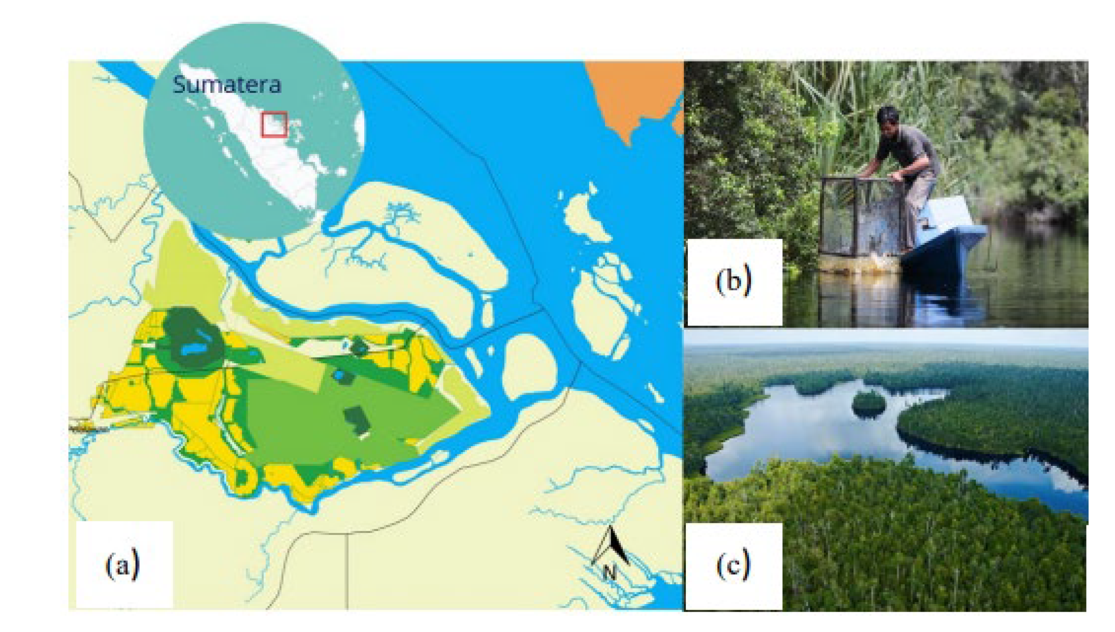
Figure 2.
Map of the Research Area in the Kampar Peninsula, Riau Province.
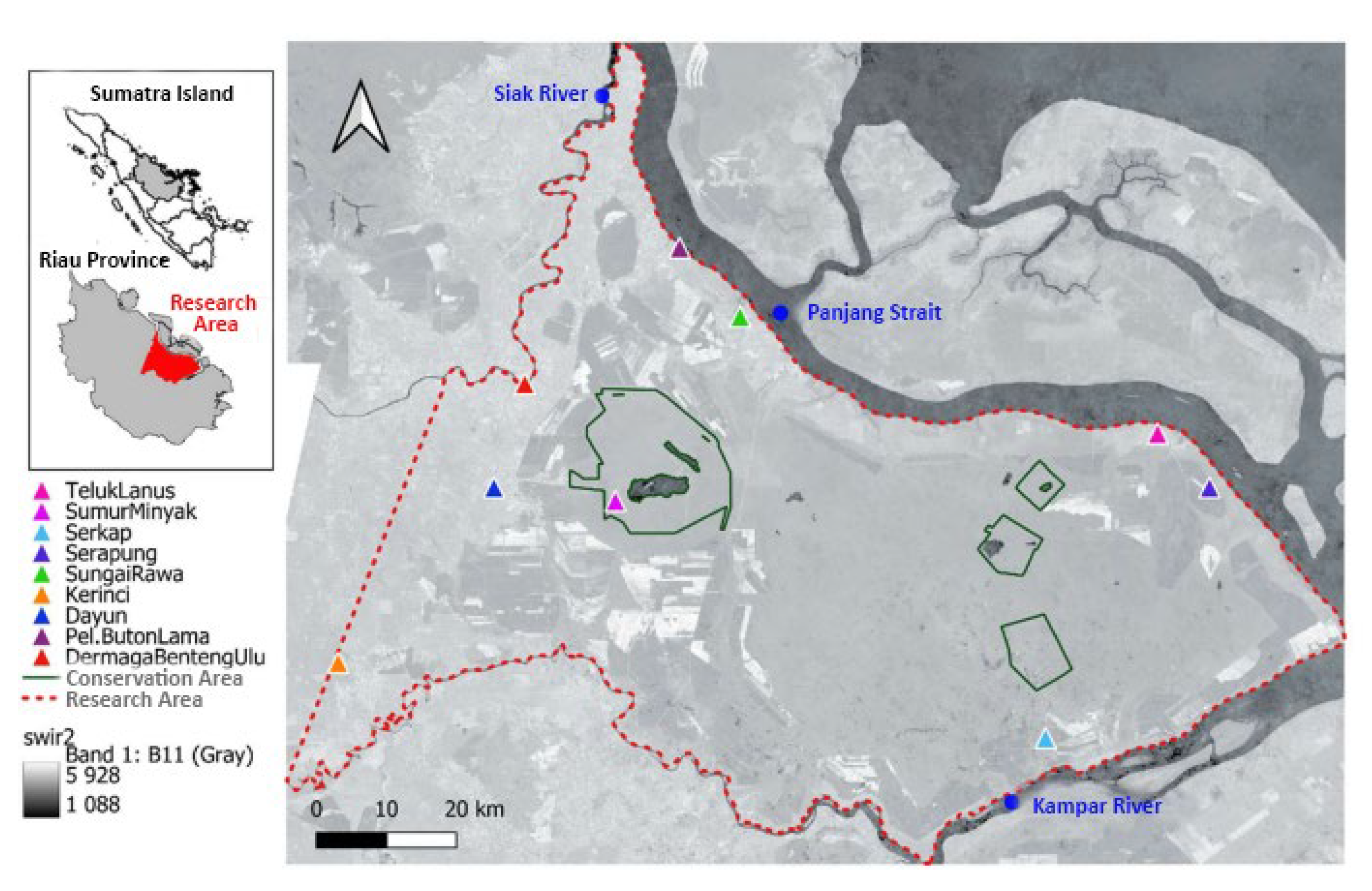
Figure 3.
Flow Chart of Selecting and Processing Data from Landsat Imagery.
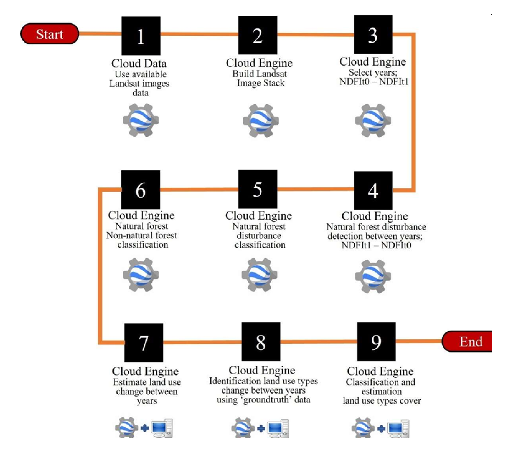
Figure 4.
Distribution Map of Ground Check Data.
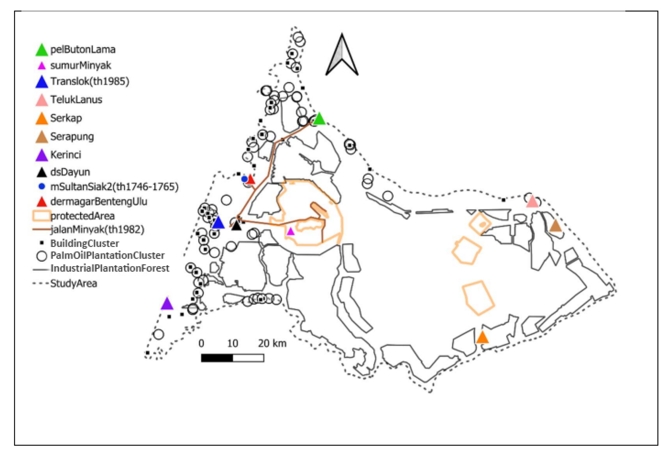
Figure 5.
Four Classification Clusters for Identifying Land Use Conditions: (A) Cluster A, consisting of Oil & Gas Industry Buildings, and Industrial Forest Plantations - Pulp & Paper; (B) Cluster B, consisting of Residential Buildings; (C) Oil Palm Plantation Cluster; and (D) Acacia Industrial Forest Plantation Cluster.
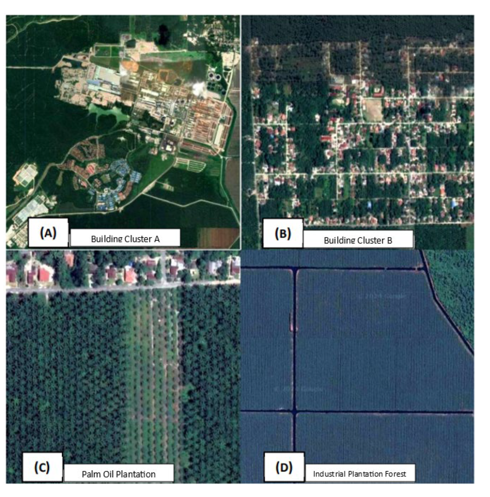
Figure 6.
NDFI Change Overview (a) NDFI Change Map between 1990-1993, 1998-2000, 2000-2003, 2008-2010, 2010-2013, 2018-2020; (b) Landsat Image (1993, 2000, 2003, 2010, 2013, 2020).
Figure 6.
NDFI Change Overview (a) NDFI Change Map between 1990-1993, 1998-2000, 2000-2003, 2008-2010, 2010-2013, 2018-2020; (b) Landsat Image (1993, 2000, 2003, 2010, 2013, 2020).
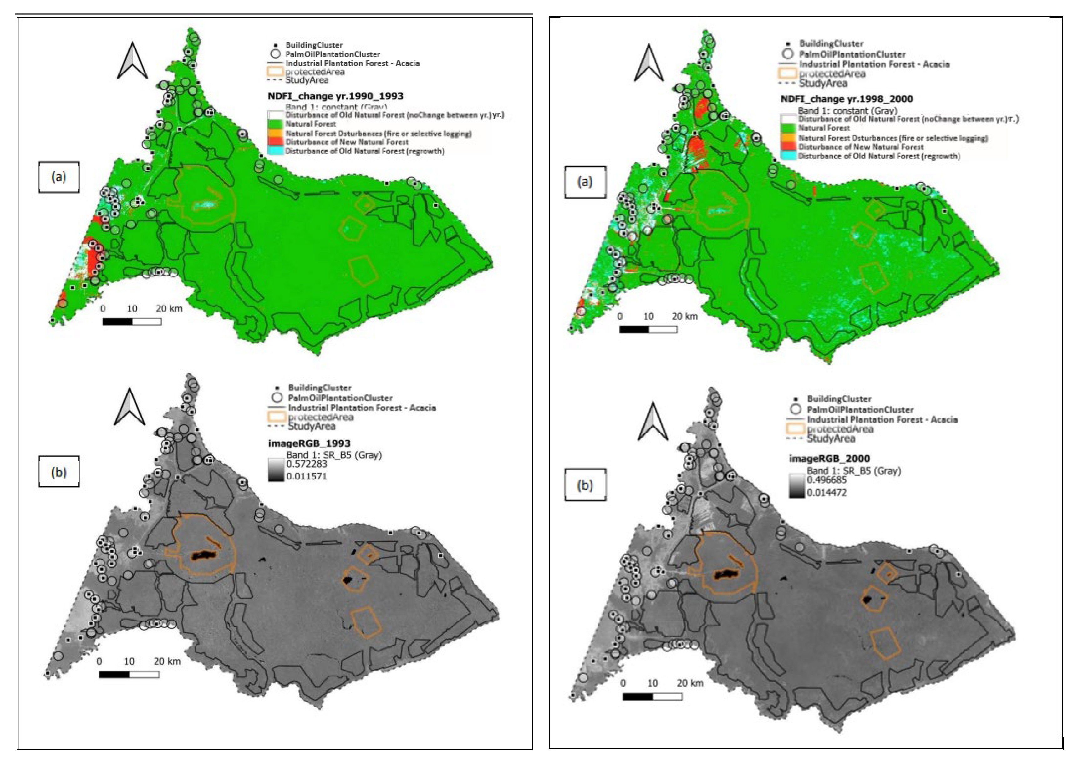
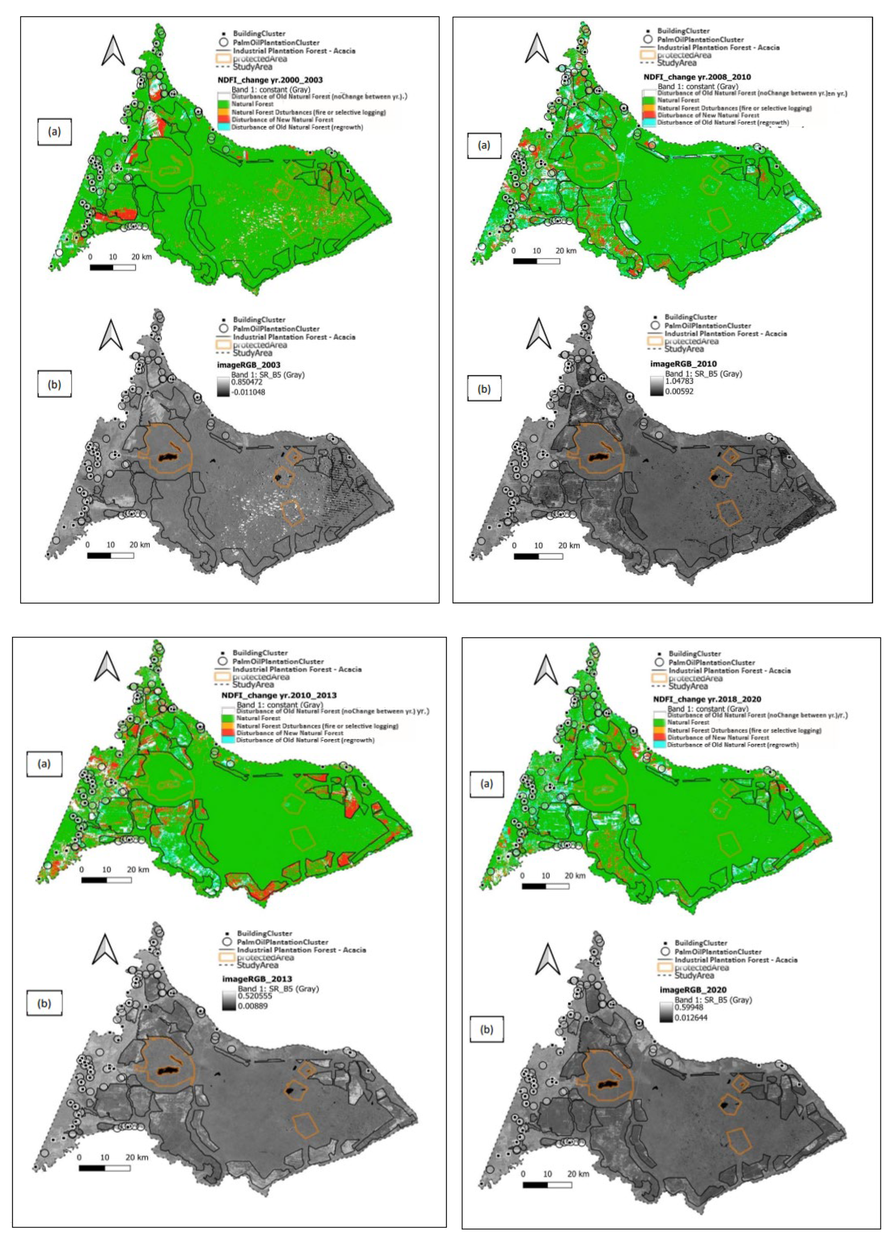
Figure 7.
Land Use Classification Map of 2020 with Ground Check Data.
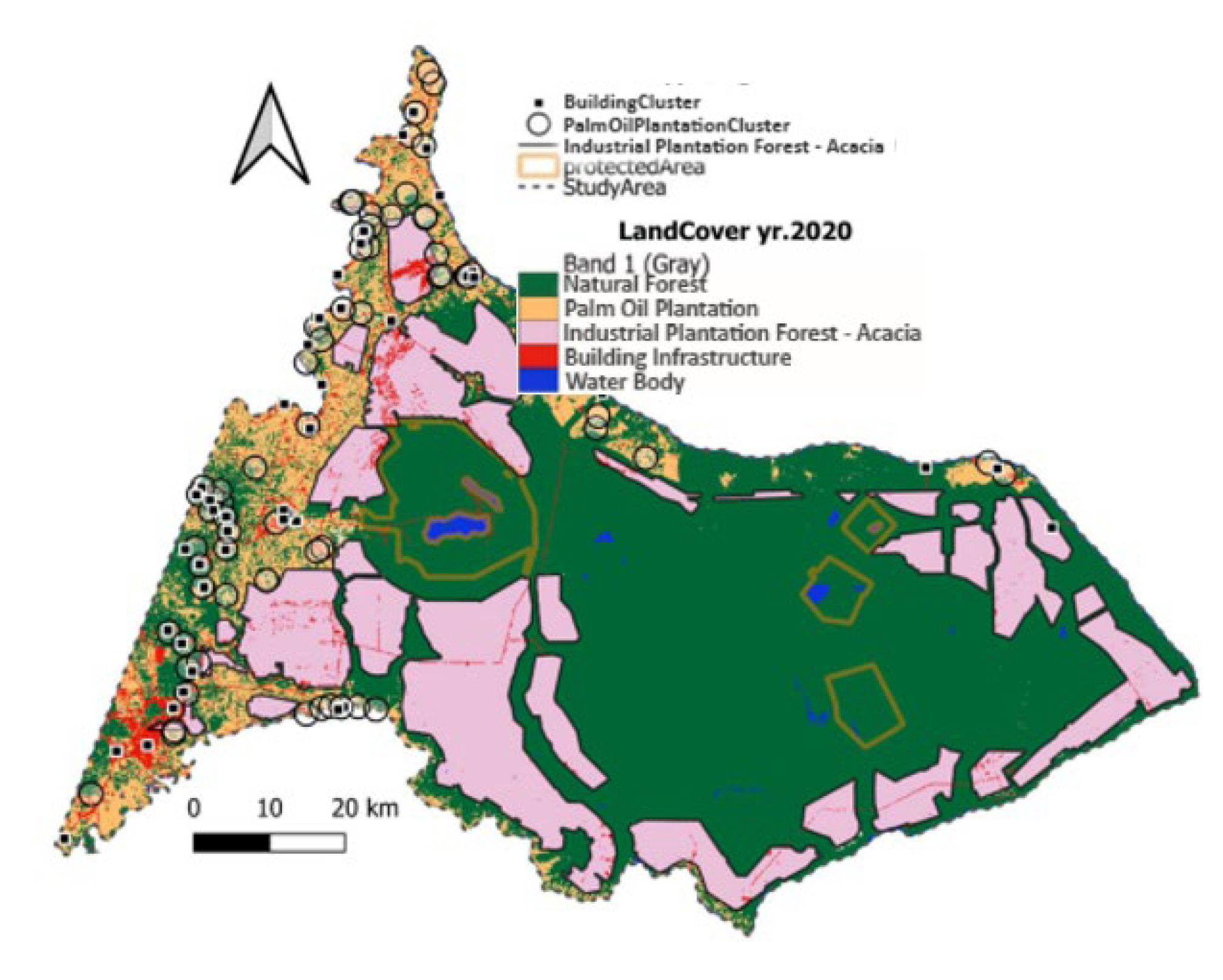
Figure 8.
Natural Forest Cover Change Trend in Kampar Peninsula (1990-2020).
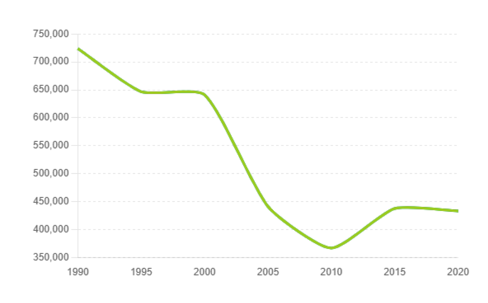
Figure 9.
Land Use Change Map Indicating the Transition from Natural Forest to Non-Forest Areas from 1990-2020. (a) Changes Occurring between 1990-1995, and (b) Changes Occurring between 2016-2020.
Figure 9.
Land Use Change Map Indicating the Transition from Natural Forest to Non-Forest Areas from 1990-2020. (a) Changes Occurring between 1990-1995, and (b) Changes Occurring between 2016-2020.
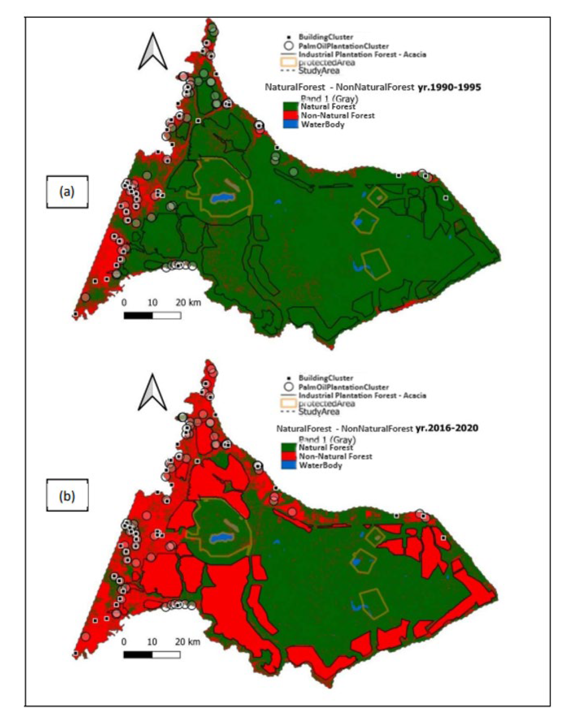
Figure 10.
NDFI Change Detection (1990-1993) in the Mempura Village Area on the Banks of the Siak River: 1. Benteng Ulu Dock, 2. Tomb of the 2nd Sultan of Siak (a) NDFI Change Map (1990-1993); (b) Landsat Image (1993).
Figure 10.
NDFI Change Detection (1990-1993) in the Mempura Village Area on the Banks of the Siak River: 1. Benteng Ulu Dock, 2. Tomb of the 2nd Sultan of Siak (a) NDFI Change Map (1990-1993); (b) Landsat Image (1993).
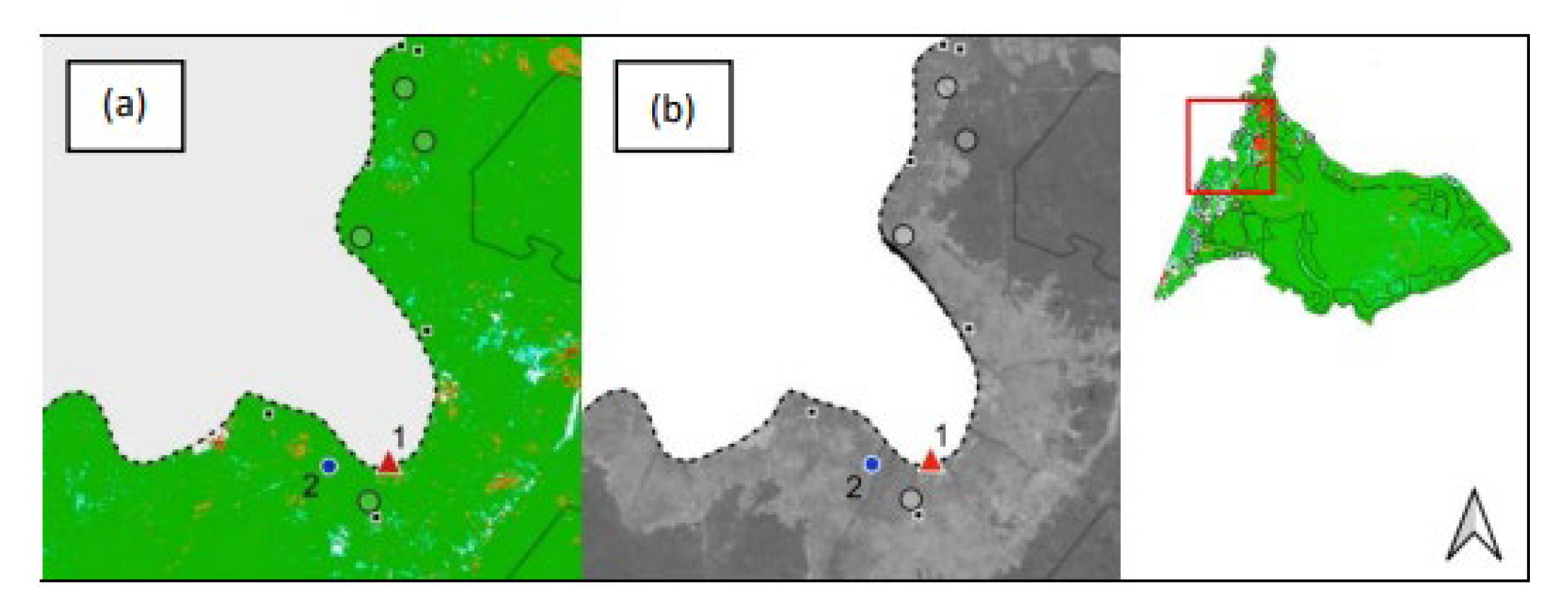
Figure 11.
NDFI Change Detection (1990-1993) in the Mempura Village Area on the Banks of the Siak River: (1) Benteng Ulu Dock, (2) Tomb of the 2nd Sultan of Siak, (3) Dayun Village, (4) Oil Road Built 1975-1982, (5) Idris Oil Well, and (6) Boundaries of Zamrud National Park (a) NDFI Change Map (1990-1993); (b) Landsat Image (1993).
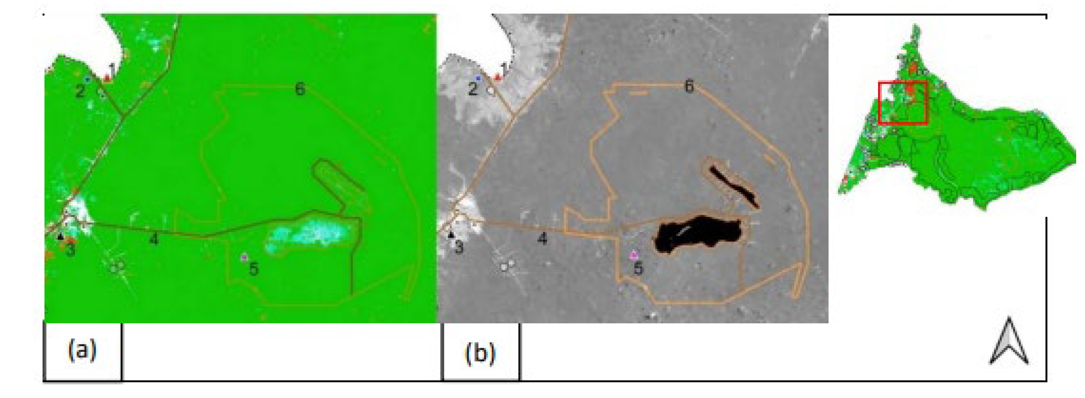
Figure 12.
NDFI Change Detection Results (1990-1993): Land cover changes occurred at locations a1, a2, and b2 in 1993 (red). Locations b1, Kerinci (8), and Translok (7) experienced previous land cover changes, showing no visual changes (white) and regrowth (light blue). (a) NDFI Change Map (1990-1993); (b) Landsat Image (1993).
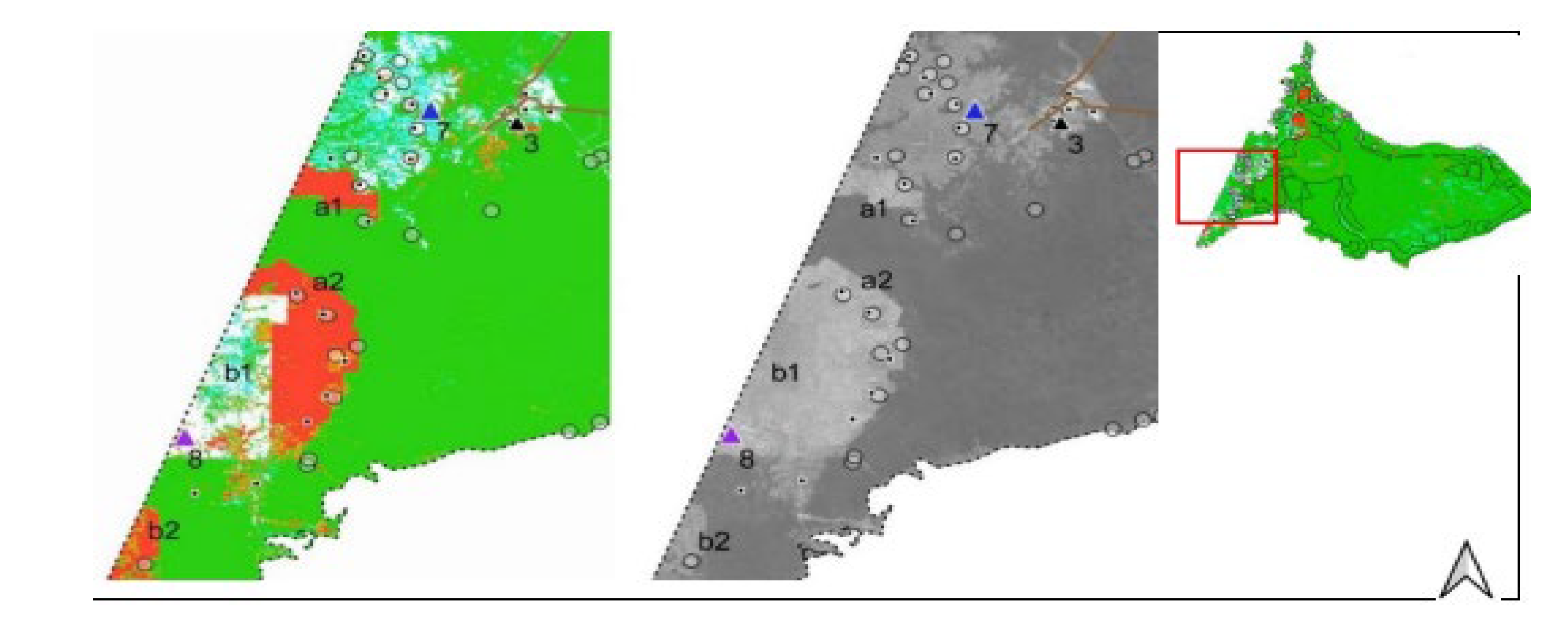
Figure 13.
NDFI Change Detection Results (2000-2003): Continued land cover changes and acacia expansion at locations a1 and a2. Location a3 shows land cover changes related to the acacia HTI industry, including a jet runway at location a4. Locations b1 and b2 indicate oil palm plantation expansion. (a) NDFI Change Map (2000-2003); (b) Landsat Image (2003).
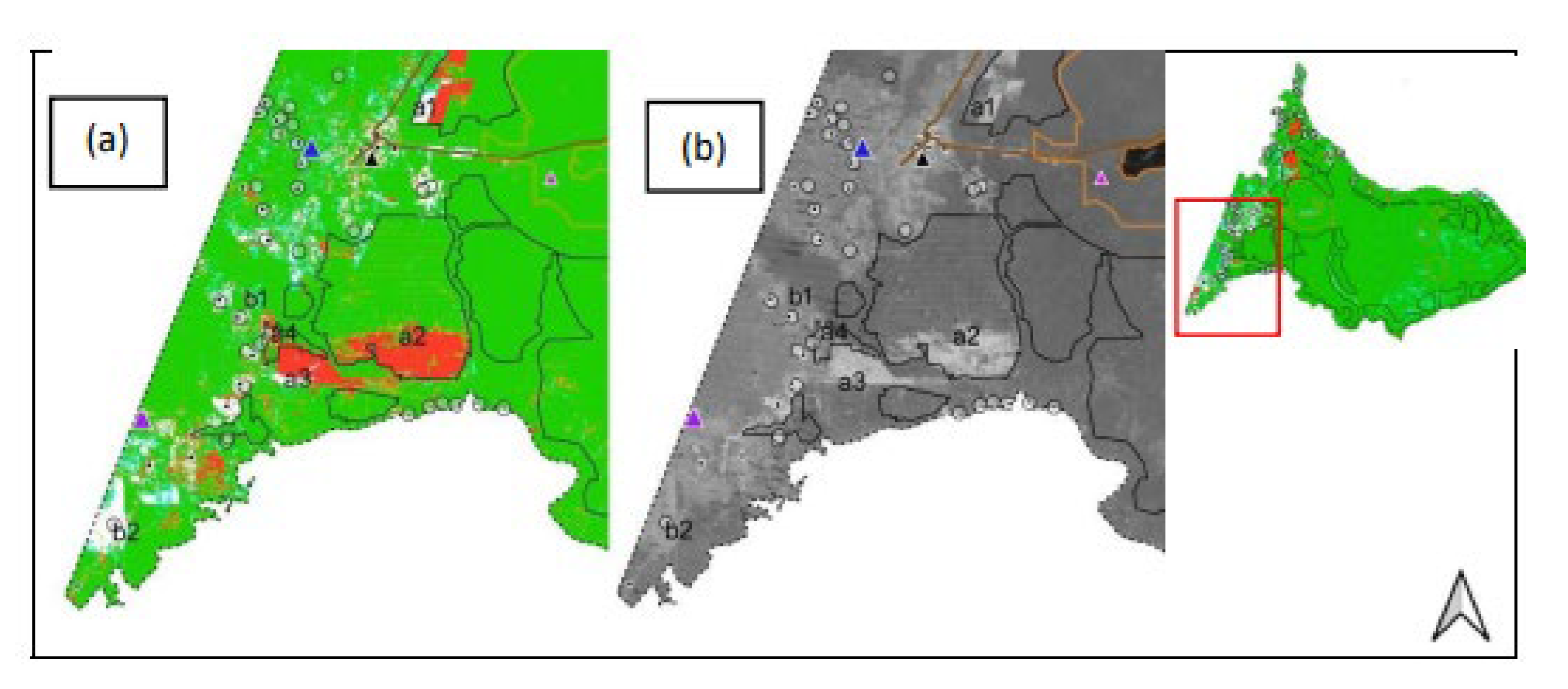

Table 1.
Spectral Endmembers (Spectral Signature) for Analyzing Spectral Mixture Endmembers Used to Estimate Fractions of Each Pixel.
Table 1.
Spectral Endmembers (Spectral Signature) for Analyzing Spectral Mixture Endmembers Used to Estimate Fractions of Each Pixel.
| Endmember | Blue | Green | Red | NIR | SWIR1 | SWIR2 |
|---|---|---|---|---|---|---|
| GV | 0.05 | 0.09 | 0.04 | 0.61 | 0.30 | 0.10 |
| NPV | 0.14 | 0.17 | 0.22 | 0.30 | 0.55 | 0.30 |
| Soil | 0.20 | 0.30 | 0.34 | 0.58 | 0.60 | 0.58 |
| Shade | 0.00 | 0.00 | 0.00 | 0.00 | 0.00 | 0.00 |
| Cloud | 0.90 | 0.96 | 0.80 | 0.78 | 0.72 | 0.65 |
Table 2.
Observation Time Groups for NDFI Change Detection.
| NDFI0 | NDFI1 | NDF12 | NDF13 | NDF4 | NDF15 | NDF16 | NDF7 | NDF18 | NDF19 | NDF10 | NDF11 | |
|---|---|---|---|---|---|---|---|---|---|---|---|---|
| time0 | 1990 | 1993 | 1995 | 1998 | 2000 | 2003 | 2005 | 2008 | 2010 | 2013 | 2015 | 2018 |
| time1 | 1993 | 1995 | 1998 | 2000 | 2003 | 2005 | 2008 | 2010 | 2013 | 2015 | 2018 | 2020 |
Table 3.
Observation Time Groups for Natural Forest and Non-Forest (FNF).
| FNFtime | FNF1 | FNF2 | FNF3 | FNF4 | FNF5 | FNF6 |
|---|---|---|---|---|---|---|
| TimeObs | 1990-1995 | 1996-2000 | 2000-2005 | 2006-2010 | 2011-2015 | 2016-2020 |
Table 4.
Area of Each Land Cover Class in 2020.
| Category | Area (Ha) | Percentage (%) |
|---|---|---|
| Forest Area | 433,395.20 | 59.9 |
| Plantation | 76,602.24 | 10.4 |
| Industrial Pulpwood - Acacia | 200,510.10 | 27.3 |
| Infrastructure | 17,680.20 | 2.4 |
| Water Bodies | 6,903.30 | 0.9 |
Table 5.
Area of Land Use Change Based on Forest Cover Change (Natural Forest and Non-Forest Areas) from 1990 to 2020.
Table 5.
Area of Land Use Change Based on Forest Cover Change (Natural Forest and Non-Forest Areas) from 1990 to 2020.
| Year | Natural Forest (ha) | Non-Natural Forest (ha) |
|---|---|---|
| 1990 | 723,895.30 | 4,292.40 |
| 1995 | 646,695.18 | 81,492.50 |
| 2000 | 641,112.03 | 87,075.65 |
| 2005 | 441,519.66 | 286,668.02 |
| 2010 | 367,125.84 | 361,061.84 |
| 2015 | 437,866.23 | 290,321.45 |
| 2020 | 433,395.20 | 294,792.48 |
Disclaimer/Publisher’s Note: The statements, opinions and data contained in all publications are solely those of the individual author(s) and contributor(s) and not of MDPI and/or the editor(s). MDPI and/or the editor(s) disclaim responsibility for any injury to people or property resulting from any ideas, methods, instructions or products referred to in the content. |
© 2024 by the authors. Licensee MDPI, Basel, Switzerland. This article is an open access article distributed under the terms and conditions of the Creative Commons Attribution (CC BY) license (http://creativecommons.org/licenses/by/4.0/).
Copyright: This open access article is published under a Creative Commons CC BY 4.0 license, which permit the free download, distribution, and reuse, provided that the author and preprint are cited in any reuse.


