
Submitted:
09 August 2024
Posted:
12 August 2024
You are already at the latest version
Abstract
The intrusion of seawater in coastal aquifers in Greece is a particularly widespread phenomenon. The coastline of Greece has a length of 15,147 km. Once groundwater resources are contaminated, remediation strategies are difficult, costly and time consuming. In this paper three coastal aquifer systems of Peloponnese are studied. Initially the main ions and cations were calculated for the three aquifers. According to the results from hydrochemical analyzes Na+,Mg2+, Ca2+, SO4-2, Cl- have high values and are affected by the intrusion of seawater into the coastal aquifers. It estimates the vulnerability of groundwater to the intrusion of seawater. Using Geographical Information Systems (GIS) software, maps are prepared for the presentation of each parameter of the GALDIT method. The main factors that affect the seawater intrusion are basically presented in the 6 letters of the acronym GALDIT. The analysis of each parameter is as follows: Groundwater occurrence (aquifer type: unconfined, confined, and leaky confined), Aquifer hydraulic conductivity, depth to groundwater Level above the sea, Distance from the shore (inland distance perpendicular from shoreline), Impact of existing status of sea water intrusion in the area and Thickness of the aquifer. The final map that emerged from the study of the three groundwater systems shows the vulnerability of seawater intrusion in Peloponnese. The maps show that the groundwater system of Larissos presents lower vulnerability to the seawater intrusion compared to the other two groundwater systems. This is because the occurrence of flysch in the northern part of the area acts as a barrier to the penetration of seawater.
Keywords:
seawater intrusion
; Argolis field
; Larissos system
1. Introduction
In Greece, the developed cities with the largest population are located in the coastal areas. The various discussions of this phenomenon in coastal areas in different countries have caused considerable concern in the international community [1]. Coastal aquifers are major sources of freshwater provision in coastal areas, especially in low precipitation areas [2]. Seawater intrusion in coastal aquifers is a widespread phenomenon. Factors that affect saltwater intrusion in coastal aquifers are tidal fluctuations, topography, recharge rate (rainfall), evaporation, seasonal changes, and climate changes [3]. In coastal aquifers, the natural equilibrium interface between freshwater and seawater can be changed by both natural and anthropogenic factors, such as overexploitation, which results in decreased sea levels and low limits of recharge [4]. Seawater intrusion is the primary and most common source of contamination in coastal aquifers, especially in arid and semiarid regions [5]. It has compromised many coastal aquifers in the summer when the tourist influx increases and forcing farmers along the coast to irrigate with brackish water [5]. This issue intensifies in coastal regions, where over 40% of the population lives within 100 kilometers of the shore [6]. One more drawback that have the unconfined aquifers to seawater intrusion is commonly observed and connected to the sea, particularly in cases where high water demand has led to a decrease in piezometric levels [7]. Geochemical studies in coastal aquifers have been extensively utilized to identify groundwater recharge zones [8]. Physio-chemical parameters such pH, electrical conductivity (EC), and major elements concentrations in groundwater were considered [5]. There are methods which mainly analyze the change in different ion ratios. A combination of laboratory and indicator-based methods can be utilized to manage groundwater resources and prioritize areas with high vulnerability to salinity [9]. A good indicator of seawater intrusion is a large gradient increase of TDS and in coastal groundwater towards the coastline [5]. The most notable phenomenon characterizing seawater intrusion is the difference between the chemical composition of the resulting brackish water and that of a simple mixture of seawater and groundwater [10]. Unlike the sorption and desorption of elements during seawater intrusion into aquifers, there exists a category of trace elements that exhibit no indication of mobilization or depletion regardless of groundwater salinization (such as Al, Cr and Pb) [11]. Therefore, practical approaches to identify vulnerability are vital for protection, management, and proper exploitation of these resources [12]. This method is one of the most common models to assess the vulnerability of coastal areas to seawater intrusion, and it is one of the most widely used methods among the rating index frameworks [13]. Moreover, coastal aquifers are difficult to assess due to the numerous factors that influence the interaction between freshwater and seawater [14]. Human activities increase in these areas, especially during the summer, and these resources are subjected to seawater intrusion due to over-exploitation and high-water pumping. Therefore, practical approaches to identify vulnerability are vital for protection, management and proper exploitation of these resources [12].
Among various methods for assessing groundwater vulnerability, the rating methods are the most popular [13]. The GALDIT method is one of the most common methods to assess the vulnerability of coastal areas to seawater intrusion and one of the most widely used methods among the rating index frameworks [13]. It shows the vulnerability of aquifers to seawater intrusion. Moreover, previous studies have compared the GALDIT method with DRASTIC, SINTACS, AVI and LOS methods. For example, the DRASTIC method addresses the physical properties of various hydrogeological environments and adopts a specific approach to the characteristics and behavior of contaminants as they move through different natural components [15]. Therefore, the original SINTACS, AVI, and LOS indices were applied, combined, and modified the account for distributions in the aquifers, replacing qualitative parameters with quantitative [16]. Moreover, there is another method to for the assessing vulnerability in coastal aquifers. The GOD method considered as most suitable GIS-based index-overlay method is used for the requirement of prompt assessment of the groundwater vulnerability and highly conducted in data-constrained regions [17]. In addition to there is another method to delineate salinization zones. The Water Quality Index (WQI) is a widely used tool for assessing the suitability of water, primarily for human consumption but also can help to delineate seawater-freshwater interactions in coastal aquifers [18]. One more method for assessing groundwater vulnerability is the EPIK method that is used in karst environments. In addition, another method to find areas that are vulnerable to contamination is the SINTACS model [19]. The findings suggest that GALDIT delivers superior and more precise results for assessing coastal vulnerability to seawater intrusion [19]. Also, the Water Quality Index (WQI), first introduced by Horton in 1965, is a widely utilized tool for evaluating the suitability of water, primarily for human consumption. The Water Quality Index (WQI) can aid in mapping the interactions between seawater and freshwater in coastal aquifers [18]. Based on the maps that are made for each parameter of the GALDIT index show accurately the extent of the infected areas. Numerous studies have been conducted to enhance the GALDIT framework by taking into account the hydrological conditions of aquifers [20]. For coastal aquifers, the GALDIT model has been crucial for assessing vulnerability to seawater intrusion [21]. It was concluded that combining various classic models based on the contamination source provides a practical approach to assessing the vulnerability to seawater intrusion in coastal aquifers on an integrated scale [22]. The main drawback of the GALDIT method is that the specific hydrogeological and geological characteristics of an area are not considered when assigning scores and weights to each variable [23]. The Larissos groundwater system is located in northwestern Peloponnese, the Romanos - Chora is located in southwestern Peloponnese, while the Argolis field in eastern Peloponnese. Intensive groundwater pumping in the Argolis field began in the 1950s, initially causing salinization of the shallow coastal aquifer layers. The irrigation water demand increased, both the number and depth of wells increased, leading to salinization of even the deepest aquifers [24]. It is known that no detailed studies have been found so far that evaluate the vulnerability and groundwater quality due to seawater intrusion in this three the coastal aquifers. Moreover, the negative effects appear in the long-term reduction of groundwater levels heightened energy consumption for pumping water from increasingly deeper levels, and deterioration in quality caused by seawater intrusion [25]. Understanding the causes and mechanisms of salinization is crucial for the sustainable management of this intensively farmed region [26]. The economic stability of the three regions relies significantly on the availability of water of suitable quality for crop irrigation so salinization causes a risk to the economic future of coastal areas [27]. Moreover, the quality of irrigation water is a significant concern because it affects to crop production, soil quality, as well as human and animal health [28]. In addition, sampling campaigns were carried out in all study areas and the major ions were determined. A deep understanding of groundwater chemistry plays a crucial role in effectively managing the available groundwater resources within shallow coastal aquifers [29]. The hydrochemical parameters including TDS and Cl/HCO3 in combination with the GALDIT method were used to validate the results of the method. The impact of natural mixing between seawater and continental water, ion exchange phenomena and the inflow of groundwater from neighboring coastal alluvial aquifers collectively contribute to the heightened salinity levels in the region [30]. The main geological formation through which seawater infiltrates in all three regions is the alluvial formation.
2. Study Areas
The GALDIT method was applied to three groundwater systems in Peloponnese (Figure 1) in order to estimate the vulnerability of different geological formations in seawater intrusion. The climate in Peloponnese is characterized as Mediterranean with dry summers. According to the first review of the management plan the groundwater system Larissos belongs to the water section of Northern Peloponnese (EL 02) and occupies an area 162.8 . In addition, the groundwater system of Romanos – Chora belongs to the water section of Western Peloponnese (EL01) with an area of 194.62 km2. Finally, the Argolis field belongs to the Eastern Peloponnese (EL03) water section with an area of 271.90 .
2.1. Study Areas
The Larissos system has an annual rainfall around 600mm/year. This study area is structured by rock formations of the Ionian Zone and is mostly covered by post-alpine sediments. More detail the Larissos groundwater system consists of the following formations: (a) Holocene formations and deposits consisting of litteral sand, lagoonal and marsh of mud and sandy material, terrestrial of sand and gravel, scree, recent cones of scree and eluvial (b) Pleistocene deposits consisting of red clayey sand and marine terrace (c) Eocene flysch from Ionian zone (d) Paleocene, Upper Cretaceous and Upper Jurassic limestones.
In the study area, the Ionian zone appears, the natural sequence of which is the Tripolis zone, overthrust nappe on Pindos zone. The faults appear in the western, northern, and southern part of the area and have a N-S and E-W direction. Furthermore, most of the visible faults occur in the limestone sequence with white and light brown limestones (Figure 2).
In addition, the Argolis field has an area 271,90 . The Argolis field has an annual rainfall around 689mm/year. The study area includes rock formations of the tectonostratigraphic Zones of Olonou - Pindos, Sub-Pelagonian, Phyllite - Quartzite series and Gavrovou – Tripolis. The area has been affected by the existence of the rock formations of these Zones where several tectonic phenomena took place. The area is covered mostly by rock formations of the Pindos Zone, which is overthrusted over flysch layers. There is generally a tendency thrusting direction from East to West. Geologically, there are postalpine sediments (Neogene, Quaternary), found mainly in the study area. In the Argolis plain there are mainly alluvial deposits.
The area of the Argolis field tectonically demarcates the "internal" from the "external" geotectonic units of the Greek space. The rift tectonics west of the plain presents different characteristics from east. In the western zone is dominated by faults of a relatively small extent, with a predominant direction NW-SE, while on the contrary, in the east, there are faults NE-SW. Rift tectonics, on the edges of the Argolic field, has created faults with main directions NW-SE and NE-SW. Two main fold-forming deformation phases can be distinguished, the Paleoalpine reflected in the Triassic and Jurassic limestones of the eastern edges of the plain, which gave folds with a NE-SW direction, and the postapline, which is mainly reflected in the Cretaceous limestones with folds in a NW-SE direction. The dominant one is that of the alpine folds and gives folds with a N-S direction axis, while the second, the new, gives folds with an E-W axis approximately. The faults are normal with a prevailing N-S direction. Evidence of sea level changes is abundant in the area (Figure 3).
Finally, the groundwater system of Romanou – Choras has an area 194,62 . The third groundwater system in Romanou – Choras has an annual rainfall around 843mm/year. This system consists of the following formations: (a) alluvial deposits and dunes (b) Pleistocene sandstones, (c) Pleiocene marls and cobblestones, (d) flysch, limestones, and cobblestones from Gavrovou-Tripolis Zone, (e) limstones and keratolites from Olonou – Pindos Zone. Geotectonically, the alpine substrate is structured by rock formations of the Olonou - Pindos and Gavrovou - Tripolis Zones, while most of it is covered by postalpine sediments (Figure 4).
In the study area there are normal NNW, NW, WNW faults. Three asymmetric trenches with a maximum width of 150 meters and a maximum depth of 20 meters are found in the conglomerates. The normal faults with SW directions create asymmetric trenches with a length of 30 meters and a maximum depth of 5 meters.
3. Materials and Methods
3.1. Data Preparation, Sampling and Analytical Procedure
Chemical analyses were carried out for the determination of major cations (, , and ) and major anions ( , , , and . All analyzes took place according to the proposed methods and standards in the Laboratory of Hydrogeology of the Department of Geology at the University of Patras. The , , , were measured using a Perkin Elmer atom absorption spectrometer. The were determined by indicator titration. The anion of were determined by method Mohr with indicator of Ag. The other main anions were measured by a Hach® DR 4000 spectrophotometer. The samples for the Romanos -Choras groundwater system and the samples for the Argolis field were collected in May 2019, while the samples for the groundwater system of Larissos were collected in May 2021. Based on the collected samples, a comparison is made for these three groundwater systems which located in the Peloponnese.
3.2. Ionic Ratio
The ionic ratio method was successfully applied by numerous researchers in order to determine the origin of the groundwater mineralization in coastal areas [6]. In this study the main ionic ratios which calculated are Na/Cl, Ca/Cl, /Cl, K/Cl, Mg/Cl, /Ca. Ion ratios were applied to show the origin of groundwater in coastal areas.
3.3. Hydrochemical Analysis
The following figures show the samples through two parameters which are the ionic concentrations of two elements given in mg/L. The straight line in the diagrams is called the dissolution-concentration line with the extreme members are the freshwater and seawater samples. When the samples are projected on this line, they come from the processes of the dissolution seawater with rainwater, while those above the line contain higher concentrations of the two elements. In Figure 5a shows the relationship between Na+ and have a positive correlation where they follow the theoretical mixing line. In the diagram Figure 5b it is therefore observed that all the samples are projected upstream of the theoretical mixing line. So, the samples contain more calcium than predicted by dissolution procedures. This occurs due to the process of ion exchange between brackish water and the sediments of the aquifer. Specifically, during the ion exchange process, sodium ions of the brackish water are exchanged with calcium ions of the sediments in aquifer. Figure 5c shows the relationship between and where most samples are concentrated above the theoretical mixing line. Various origins of this element mainly mineral-water interactions within the aquifer the dissolution of gypsum and agricultural pollution [5]. In Figure 5d the most samples from Larissos and Romanos-Choras groundwater system are shown above the theoretical mixing line which are the saline samples. Most of the samples from the Argolis field are shown below the theoretical mixing line. Figure 5e shows the relationship between and where many samples from all three water systems are listed above the theoretical mixing line. This suggests other sources for the enrichment in Mg particularly the dissolution of gypsum and carbonates in the aquifer [5]. In Figure 5f the correlation of with indicates poor dissolution of gypsum compared to the calcite dissolution [31].
3.4. Major Ion Indicators
The Figure 6a shows the ratio Mg/Ca where the samples are close to the mixing line. According to the Figure 6b the samples from the Larissos groundwater system are appear upstream of the mixing line. On the other hand, the samples from the Argolis field are appear near and above the mixing line water. The content of in groundwater also increases with the increase of content which consistent with the mixing line indicating that in groundwater mainly comes from seawater [32]. The SO4/Cl ratio decreases in relation to the increase of (Figure 6c). The same happens with the ratio Ca/SO4 (Figure 6d).
3.5. Piper Diagram
In the Piper trilinear diagram demonstrate the geochemical description of groundwater types [31]. The diagram shows the results for the three groundwater systems. The fresh water belongs to the Ca-Mg-HCO3 type, mixed water belongs to the Ca-Mg-Cl type, and saline water belongs to Na-Cl [31]. The samples in the blue circle are fresh water. Two samples in the red field are for waters that are close to the sea and are considered seawater. On the other hand, there are some wells where they contain mixing water since the original sodium-chlorine composition has been replaced by calcium-sodium and chloride. The rest are mixed water Ca-Mg-Cl with a conservative mixture of seawater and freshwater [33]. It is observed that ion exchange reactions occur in this specific area. In particular, the cationic exchange plays a very important role in shaping the quality of groundwater. Seawater has a sodium chloride composition while the fresh water of coastal aquifers is calcium carbonate. Cation exchange takes place when seawater intrudes inland. The samples have enough calcium and chlorine to indicate a calcareous character (Figure 7).
3.6. Gibbs Diagram
The Gibbs diagram (Figure 8) is generally used to indicate the dominant effect in the groundwater evolution [34]. The mechanism of water-rock interactions by plotting TDS vs Na/(Na+Ca) and Cl/(Cl+HCO3) in the Gibbs diagram. The trend shows the changes in salt and ions ratios during the groundwater evolution dominant by different control conditions [34]. In the study areas the groundwater samples are plotted near the seawater region and mainly affected by evaporation processes.
3.7. Statistical Analysis
For the groundwater system Larissos was constructed the boxplot (Figure 9a) for the main ions. First, regarding the cations for the groundwater system of Larissos the dominant element is Ca2+ with a maximum value is 355.2 mg/L, the minimum value is 56 mg/L, and the mean value is 165.6 mg/L. The Na+ is the next dominant cation in the range, with a maximum value is 610 mg/L, a control value is 47 mg/L, and a mean value is 125 mg/L. Ca2+ is not only derived from mineral dissolution and seawater but also can be affected by evaporation and cation exchange [32]. The Mg2+ has a maximum value is 242 mg/L, the minimum value is 9.8 mg/L, and a mean value is 37.56 mg/L. The main anion is , the maximum value is 1412 mg/L, the minimum value is 35 mg/L, and a mean value is 151 mg/L. The range of is 122 mg/L to 570.96 mg/L and the mean value is 397.72 mg/L. the range of SO4 is 0 mg/L to 600 mg/L and the mean value is 160 mg/L.
Furthermore, for the Argolis field dominant element for the cations is Ca2+ with a maximum value is 440 mg/L, the minimum value is 46.8 mg/L, and the mean value is 108 mg/L. The Na+ concentration range is 482.5 mg/L to 4.9 mg/L and a mean value is 30.9 mg/L. The Mg2+ has a maximum value is 268.2 mg/L, the minimum value is 0.4 mg/L, and a mean value is 19.5 mg/L. The main anion is , the maximum value is 1700 mg/L, the minimum value is 9 mg/L, and a mean value is 81 mg/L. The range of is 146.4 mg/L to 376.9 mg/L and the mean value is 284.2 mg/L. the range of SO4 is 1.1 mg/L to 326 mg/L and the mean value is 40.8 mg/L (Figure 9b).
Moreover, for the Romanos-Choras groundwater system the dominant cation is Na+, with a concentration range of 19.4 mg/L to 480 mg/L and a mean value of 68.4 mg/L. The Ca2+ concentration range is 95.2 mg/L to 296.8 mg/L and the mean value is 133 mg/L. The Mg2+ has a maximum value of 47.3 mg/L, a minimum value of 1.2 mg/L and a mean value of 13.1 mg/L. The main anion is and the maximum value is 468 mg/L, the minimum value is 35.3 mg/L, and a mean value is 98.1 mg/L. The range of is 264.7 mg/L to 407.4 mg/L and the mean value is 348.3 mg/L. The range of SO4 is 24.5 mg/L to 490 mg/L and the mean value is 125.8 mg/L (Figure 9c).
3.8. Mineral Saturation Indices
The saturation indices were calculated for the main components which are found in the aquifer matrix using PHREEQC [35]. The main phases that were calculated are calcite, dolomite, aragonite, and halite. In Figure 10 the groundwater system of Larissos appeared to be in equilibrium or oversaturated with respect to the other two aquifers. Water samples that have a negative value of the saturation indices mean that they are undersaturated. In addition, the saturation index for calcite is positive for all the samples of the Larissos groundwater system, while for the other two groundwater systems there are some samples which are less mineralized. For the saturation index of dolomite, almost the same thing happens as for calcite. The saturation index of aragonite appears to have negative values for the Argolis field and for the groundwater system of Romanos – Choras meaning this phase would be susceptible to dissolution if it were located in an aquifer matrix [36]. The saturation index for halite ranged between -9 and -4.5 with highly negative values.
3.9. Correlation Analysis
Correlation analysis is a method to investigate the degree of similarities and the probable interrelations among the chemical and the physical parameters [10]. Multivariate analysis is used as an analysis tool to reduce and organize large sets of hydrogeochemical data into groups with similar properties [37]. The Pearson correlation is an indicator used to show the relationship between two parameters. Firstly, in Table 2 are presented the results from the Larissos groundwater system. Based on the Pearson correlation it was found that correlation between EC and the major ions , and with a correlation coefficient of 0.745, 0.840, 0.702 respectively is relatively high. The high correlation implies that the groundwater chemistry is controlled by these anions [38]. Secondly, in Table 3 are presented the results from Argolis field. EC was related to TDS , , Na+, K+, Ca2+, with a correlation coefficient of 0.955, 0.927, 0.857, 0.944, 0.755, 0.933, 0.755, respectively. There is a strong positive correlation with Cl and TDS, , , Mg2+ that reflects signs of seawater influences on groundwater salinity [37]. The third groundwater system of Romanos – Choras (Table 4) showed a very significant correlation between EC and TDS (0.928), EC and Cl (0.948), EC and Na+ (0.853), EC and K+(0.785), EC and Ca2+(0.737). Finally, the pH correlated negatively with all chemical parameters except for groundwater system of Larissos has positive correlate for chemical constituents , , Na+ and K+.

Table 1.
Pearson’s correlation matrix for analyzed parameters of groundwater system of Larissos.
| pH | EC | TDS | HCO3 | Cl | SO4 | NO3 | Na | K | Ca | Mg | |
|---|---|---|---|---|---|---|---|---|---|---|---|
| pH | 1 | ||||||||||
| EC | -0.209 | 1 | |||||||||
| TDS | -0.219 | 0.897 | 1 | ||||||||
| HCO3 | 0.313 | -0.451 | -0.446 | 1 | |||||||
| Cl | 0.138 | 0.745 | 0.851 | -0.234 | 1 | ||||||
| SO4 | -0.637 | 0.540 | 0.577 | -0.351 | 0.129 | 1 | |||||
| NO3 | -0.447 | 0.494 | 0.412 | -0.721 | 0.008 | 0.686 | 1 | ||||
| Na | 0.002 | 0.606 | 0.708 | 0.120 | 0.745 | 0.433 | -0.046 | 1 | |||
| K | 0.449 | 0.407 | 0.529 | -0.093 | 0.818 | -0.285 | -0.190 | 0.369 | 1 | ||
| Ca | -0.460 | 0.840 | 0.865 | -0.680 | 0.572 | 0.665 | 0.694 | 0.332 | 0.285 | 1 | |
| Mg | 0.161 | 0.702 | 0.768 | -0.311 | 0.904 | 0.013 | 0.035 | 0.473 | 0.884 | 0.603 | 1 |
Table 2.
Pearson’s correlation matrix for analyzed parameters of groundwater system of Argolis field.
Table 2.
Pearson’s correlation matrix for analyzed parameters of groundwater system of Argolis field.
| pH | EC | TDS | HCO3 | Cl | SO4 | NO3 | Na | K | Ca | Mg | |
|---|---|---|---|---|---|---|---|---|---|---|---|
| pH | 1 | ||||||||||
| EC | -0.619 | 1 | |||||||||
| TDS | -0.657 | 0.955 | 1 | ||||||||
| HCO3 | -0.391 | 0.289 | 0.315 | 1 | |||||||
| Cl | -0.567 | 0.927 | 0.967 | 0.210 | 1 | ||||||
| SO4 | -0.584 | 0.857 | 0.872 | 0.336 | 0.779 | 1 | |||||
| NO3 | -0.392 | 0.132 | 0.244 | 0.093 | 0.057 | 0.263 | 1 | ||||
| Na | -0.579 | 0.944 | 0.944 | 0.405 | 0.936 | 0.865 | 0.005 | 1 | |||
| K | -0.533 | 0.755 | 0.715 | 0.416 | 0.689 | 0.646 | 0.092 | 0.754 | 1 | ||
| Ca | -0.651 | 0.933 | 0.930 | 0.168 | 0.867 | 0.862 | 0.351 | 0.835 | 0.649 | 1 | |
| Mg | -0.468 | 0.755 | 0.849 | 0.328 | 0.881 | 0.616 | 0.088 | 0.794 | 0.557 | 0.650 | 1 |
Table 4.
Pearson’s correlation matrix for analyzed parameters of groundwater system of Romanos - Choras.
Table 4.
Pearson’s correlation matrix for analyzed parameters of groundwater system of Romanos - Choras.
| pH | EC | TDS | HCO3 | Cl | SO4 | NO3 | Na | K | Ca | Mg | |
|---|---|---|---|---|---|---|---|---|---|---|---|
| pH | 1 | ||||||||||
| EC | -0.476 | 1 | |||||||||
| TDS | -0.318 | 0.928 | 1 | ||||||||
| HCO3 | -0.314 | -0.028 | 0.054 | 1 | |||||||
| Cl | -0.403 | 0.948 | 0.945 | -0.049 | 1 | ||||||
| SO4 | -0.007 | 0.396 | 0.584 | 0.509 | 0.371 | 1 | |||||
| NO3 | -0.179 | 0.593 | 0.556 | -0.469 | 0.533 | -0.018 | 1 | ||||
| Na | -0.369 | 0.853 | 0.857 | 0.335 | 0.828 | 0.571 | 0.250 | 1 | |||
| K | -0.402 | 0.785 | 0.621 | -0.232 | 0.716 | 0.015 | 0.748 | 0.582 | 1 | ||
| Ca | -0.273 | 0.737 | 0.805 | -0.249 | 0.804 | 0.310 | 0.654 | 0.430 | 0.547 | 1 | |
| Mg | 0.150 | 0.145 | 0.304 | 0.498 | 0.153 | 0.789 | -0.074 | 0.244 | -0.131 | 0.155 | 1 |
3.10. GALDIT Framework
The GALDIT framework introduced by Chachadi (2005) [1] is widely used as a tool to assess the groundwater vulnerability in coastal aquifers. The GALDIT method includes six parameters: groundwater (G), aquifer hydraulic conductivity (A), level of groundwater above sea level (L), distance from the shoreline (D), impact of the existing status of seawater intrusion (I), and thickness of the aquifer (T). Each of the six parameters has a predetermined unchanging weight that expresses its relative importance in seawater intrusion. The GALDIT method is applied for three groundwater systems in Peloponnese (Larissos, Romanou – Choras and Argolis field), where data from several boreholes were also collected, and the GALDIT index was calculated according to the equation 2.
Wi: is the weight of each parameter
Ri: is the calibration of the parameter at specific points (borehole positions)
Each parameter has specific numerical ranges. The lowest vulnerability value takes the value 2.5 and the maximum is 10.
4. Results and Discussion
4.1. GALDIT Layers
The parameter layers were prepared in raster format in ArcGIS software environment. The six parameters of the GALDIT method were calculated separately for each groundwater system and maps were constructed for each parameter.
4.1.1. Groundwater Occurrence G
This parameter is important because it shows the potential of seawater to penetrate groundwater aquifers (Figure 11). Aquifers are classified into four types of unconfined aquifer, confined, leaky confined and bounded aquifer. According to the study, in the groundwater systems of Romanou – Choras and Larissos the types of aquifers that appear are the unconfined and leaky confined aquifer. These two types are rated as 7.5 and 5 respectively. Furthermore, in these two groundwater systems the aquifer developed in the alluvial deposits is unconfined, while the aquifer of the Neogene sediments is leaky unconfined. More than one aquifer is being investigated in the Argolis field because the groundwater system in this area is complex and difficult to separate. In the Argolis field two types of aquifers appear, such as unconfined aquifer and confined aquifer. These two types are rated as 7.5 and 10 respectively.
4.1.2. Aquifer Hydraulic Conductivity A
The hydraulic conductivity parameter needs to calculate by pumping tests, but it was not possible to execute for the three areas, so the data were taken from the literature. The hydraulic conductivity for the Romanos -Choras groundwater system has a value of 15-20 m/day [39]. For the Larissos groundwater system according to Stavropoulos [40] the value of hydraulic conductivity in the western part is 4.4 m/day. In the eastern part the value is 2.16 m/day. In the Argolis field has been made a division into two categories where the values range from 20-30 m/d and 10-15 m/d [41]. The area is divided into two general geological formations that correspond to the above values, the limestones of Tripoli and Pindos zones and the Quaternary - Neogene deposits. According to the GALDIT method the system Larissos is rated 2.5 and the others two systems are rated 7.5. (Figure 12)
4.1.3. Level of Groundwater above the Sea Level L
The level of groundwater in relation to the average altitude of the sea is an important factor in seawater intrusion. Piezometric maps were constructed for each groundwater system. The hydraulic head ranged from 3 to 28 m for the Larissos groundwater system based on measurements from 16 boreholes. In the groundwater system of Romanou – Choras the hydraulic head ranged from 0 – 2.55 m based on data from 9 boreholes. Finally, in the Argolis field it ranged from -196 – 104 m based on measurements of 32 boreholes. According to maps for the Larissos and the Romanos-Choras systems a drawdown from east to west is observed, while for the Argolis field from west to east (Figure 13).
4.1.4. Distance from the Shoreline D
Τhe impact of seawater intrusion decreases gradually further away from the coast. This parameter uses large value ranges for scoring. The measurement was taken using the software ArcGIS. The parameter has 4 categories ranging from 2.5 to 10. When the borehole is close to the shore with <5000 m then it has the highest vulnerability in water intrusion. In addition, in all groundwater systems there are boreholes which fall into the category of short distance. (Figure 14)
4.1.5. Impact of Existing Status of Seawater Intrusion I
High concentrations of chloride in groundwater systems indicate the possibility of seawater intrusion. Due to over-pumping of aquifers by humans usually a negative balance in groundwater is created. In addition, TDS is used as an index that shows where the seawater intrusion appears. However, in this category we calculate the Revelle index +. The Revelle index was calculated according to the results of the chemical analyses. When the Revelle index has values > 10 then it is considered that there is seawater intrusion. The most severe problem in all groundwater systems occurs in those boreholes located at a short distance from the shore. (Figure 15)
4.1.6. Thickness of the Aquifer T
This parameter indicates the intensity and magnitude of water intrusion in coastal areas. Moreover, the greater the thickness of the aquifer, the greater the intensity of seawater intrusion and conversely. In this category data are collected from geophysical surveys or from research boreholes. The values for thickness are <5 m, 5 m–7.5 m, 7.5 m–10 m and >10 m (Figure 16).
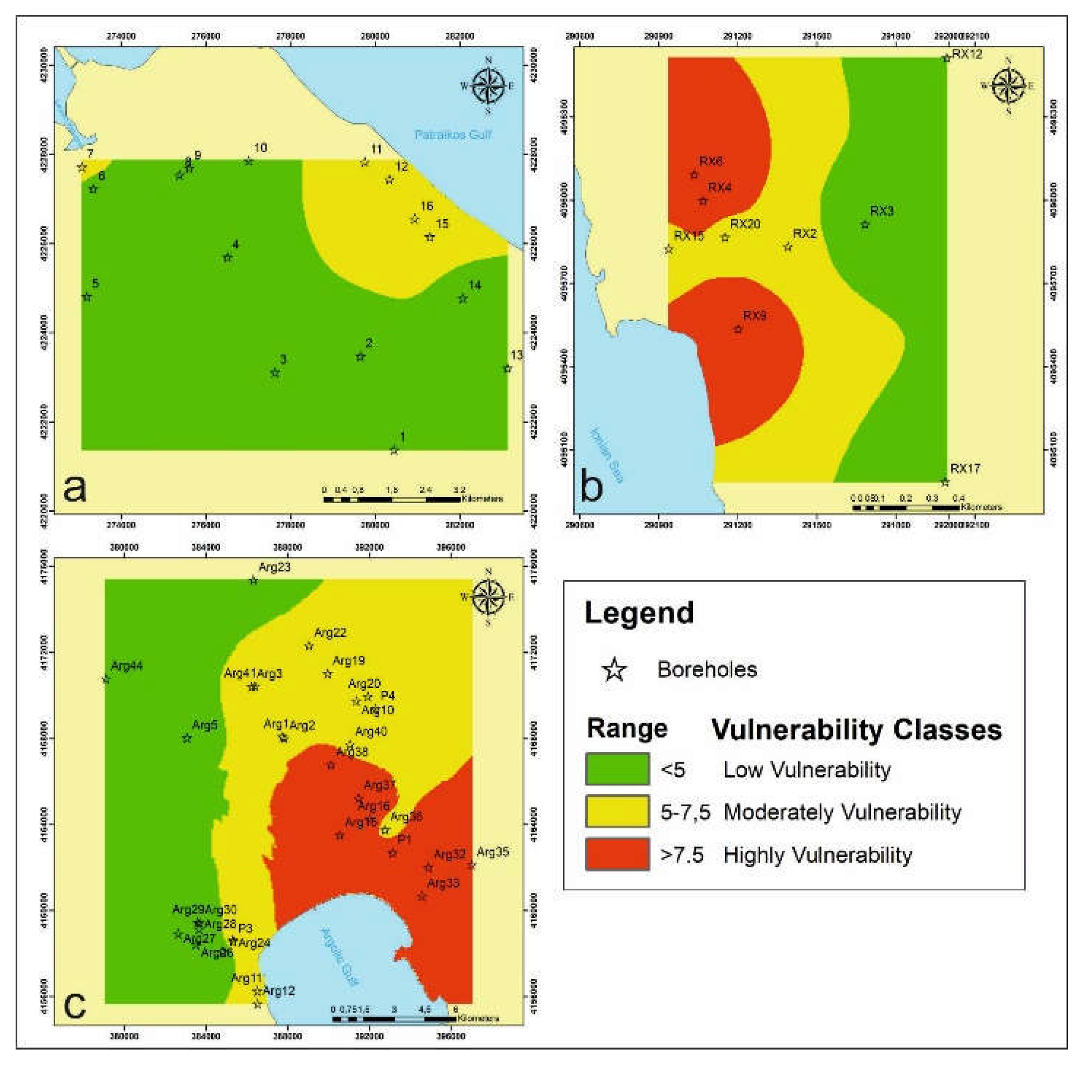
4.2. GALDIT Framework
In this study, the GALDIT method was used to determine the vulnerability of seawater intrusion in coastal areas. The maps were created in ArcGIS environment have differences in each groundwater system. Two vulnerabilities arose in the groundwater system of Larissos (Figure 17a). The first one is characterized as low vulnerability which appears in the interior of the area. In addition, near the coastal area, the GALDIT index presents moderate vulnerability. Furthermore, in the groundwater system of Romanou - Choras all categories appear (Figure 17b). The first category that has low vulnerability ratios appears inland. Then follows the moderate vulnerability ratios and near the coastal area the system shows high vulnerability ratios in terms of seawater intrusion. Initially, in the Argolis field all categories of the GALDIT index appear (Figure 17c). The factor Revelle shows the same distribution as the GALDIT index. Also, vulnerability values less than 5, in green, extend to the western part of the interior of the area. Medium vulnerability, with vulnerability ratios ranging from 5 to 7.5, in yellow, extend between zones 1 and 3. Moreover high vulnerability ratios greater than 7.5, in red, extend to the Southeastern part of the study area, in a direction parallel to the coastline.
4.3. Validation Method
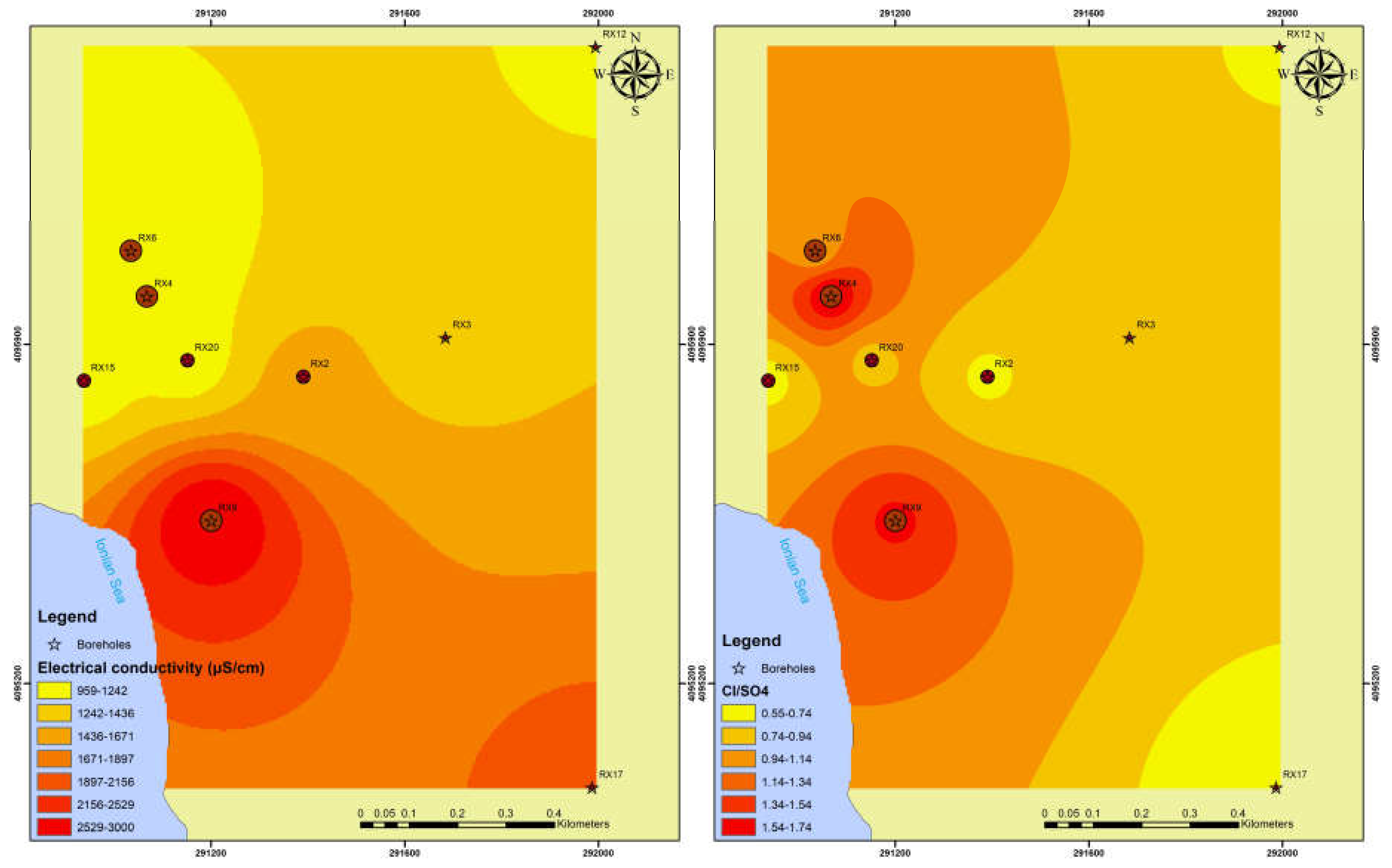
The model validated with two parameters, the EC values and the index /Cl (Figure 18, Figure 19 and Figure 20). High electrical conductivity values are a first indicator for seawater intrusion. Moreover, the above index was used because the increases with the increasing of Cl. These areas shown very high vulnerability of the seawater intrusion. In addition, the high EC values show a significant correlation with the GALDIT method.
5. Conclusions
High concentrations of TDS and control groundwater quality. For the Larissos groundwater system the TDS ranged from 300 mg/L to 2702 mg/L and from 34 mg/L to 1412 mg/L. These parameters show a positive correlation and appear increased in the western, central, and northwestern part of the study area. Moreover, for the Argolis field the TDS ranged from 269 mg/L to 3553 mg/L and from 9 mg/L to 1700 mg/L. These parameters show a positive correlation and appear increased in the southern and southeastern part of the study area. Also, for the Romanos - Choras groundwater system the TDS ranged from 515.2 mg/L to 1612.2 mg/L and from 35.31 mg/L to 468 mg/L. These parameters show a positive correlation and appear increased in the coastal area and in the central part of the study area. According to the calculations of the anions and cations, five boreholes from the groundwater system of Larissos show that there is seawater intrusion in the area. On the other hand, high values of appear in all three groundwater systems. The increased concentration is due to the use of nitrogen fertilizers. Nitrate concentrations should be considered carefully because several wells exceed the drinking water limit. Additionally, the saturation indices of calcite, dolomite and halite show that the dissolution of salts affected the aquifer salinization.
In this study, the GALDIT method was studied and applied in three groundwater systems of the Peloponnese. According to the vulnerability maps of the GALDIT framework different levels of seawater intrusion are observed. The coastal aquifers of all three groundwater systems show great vulnerability near the shoreline. The Larissos system shows lower vulnerability than the other two systems. In addition, simple linear regression analysis was applied in Larissos system between the GALDIT index and the results of TDS and EC. According to the results, the GALDIT framework does not accurately show the vulnerability, and this is confirmed by the correlation between the values of TDS. Moreover, the Pearson correlation was used in the other two groundwater systems between the GALDIT index and the values of TDS and Cl/HCO3. In addition, the results of the study provide information on the three groundwater systems for seawater intrusion. This knowledge is very important for the water management and protection coastal aquifers.
According to the results, in two groundwater systems of Larissos and Romanos - Choras, more sampling campaings are necessary in order to gain more representative results.
Funding
This research received no external funding.
References
- Zhang, Z.; Yi, L. Research Methods for Seawater Intrusion in China and Recommendations for Novel Radium-Radon Technologies. Marine Environmental Research 2024, 198, 106530. [Google Scholar] [CrossRef]
- Amarni, N.; Fernane, L.; Naili, M.; Lounas, R.; Belkessa, R. Mapping of the Vulnerability to Marine Intrusion “in Coastal Cherchell Aquifer, Central Algeria” Using the GALDIT Method. Groundwater for Sustainable Development 2020, 11, 100481. [Google Scholar] [CrossRef]
- Rani, N.N.V.S.; Satyanarayana, A.N.V.; Bhaskaran, P.K.; Rice, L.; Kantamaneni, K. Assessment of Groundwater Vulnerability Using Integrated Remote Sensing and GIS Techniques for the West Bengal Coast, India. Journal of Contaminant Hydrology 2021, 238, 103760. [Google Scholar] [CrossRef] [PubMed]
- Ayed, B.; Jmal, I.; Sahal, S.; Bouri, S. The Seawater Intrusion Assessment in Coastal Aquifers Using GALDIT Method and Groundwater Quality Index: The Djeffara of Medenine Coastal Aquifer (Southeastern Tunisia). Arab J Geosci 2018, 11, 609. [Google Scholar] [CrossRef]
- Telahigue, F.; Mejri, H.; Mansouri, B.; Souid, F.; Agoubi, B.; Chahlaoui, A.; Kharroubi, A. Assessing Seawater Intrusion in Arid and Semi-Arid Mediterranean Coastal Aquifers Using Geochemical Approaches. Physics and Chemistry of the Earth, Parts A/B/C 2020, 115, 102811. [Google Scholar] [CrossRef]
- Goswami, S.; Rai, A.K. Identifying Intrusion of Seawater in Coastal Aquifers by Modified GALDIT (M-GALDIT) Index. Groundwater for Sustainable Development 2024, 25, 101173. [Google Scholar] [CrossRef]
- De Montety, V.; Radakovitch, O.; Vallet-Coulomb, C.; Blavoux, B.; Hermitte, D.; Valles, V. Origin of Groundwater Salinity and Hydrogeochemical Processes in a Confined Coastal Aquifer: Case of the Rhône Delta (Southern France). Applied Geochemistry 2008, 23, 2337–2349. [Google Scholar] [CrossRef]
- Cartwright, I.; Weaver, T.R.; Cendón, D.I.; Fifield, L.K.; Tweed, S.O.; Petrides, B.; Swane, I. Constraining Groundwater Flow, Residence Times, Inter-Aquifer Mixing, and Aquifer Properties Using Environmental Isotopes in the Southeast Murray Basin, Australia. Applied Geochemistry 2012, 27, 1698–1709. [Google Scholar] [CrossRef]
- Motevalli, A.; Moradi, H.R.; Javadi, S. A Comprehensive Evaluation of Groundwater Vulnerability to Saltwater Up-Coning and Sea Water Intrusion in a Coastal Aquifer (Case Study: Ghaemshahr-Juybar Aquifer). Journal of Hydrology 2018, 557, 753–773. [Google Scholar] [CrossRef]
- Moujabber, M.E.; Samra, B.B.; Darwish, T.; Atallah, T. Comparison of Different Indicators for Groundwater Contamination by Seawater Intrusion on the Lebanese Coast. Water Resour Manage 2006, 20, 161–180. [Google Scholar] [CrossRef]
- Mora, A.; Mahlknecht, J.; Ledesma-Ruiz, R.; Sanford, W.E.; Lesser, L.E. Dynamics of Major and Trace Elements during Seawater Intrusion in a Coastal Sedimentary Aquifer Impacted by Anthropogenic Activities. Journal of Contaminant Hydrology 2020, 232, 103653. [Google Scholar] [CrossRef]
- Khosravi, K.; Bordbar, M.; Paryani, S.; Saco, P.M.; Kazakis, N. New Hybrid-Based Approach for Improving the Accuracy of Coastal Aquifer Vulnerability Assessment Maps. Science of The Total Environment 2021, 767, 145416. [Google Scholar] [CrossRef]
- Bordbar, M.; Neshat, A.; Javadi, S.; Pradhan, B.; Aghamohammadi, H. Meta-Heuristic Algorithms in Optimizing GALDIT Framework: A Comparative Study for Coastal Aquifer Vulnerability Assessment. Journal of Hydrology 2020, 585, 124768. [Google Scholar] [CrossRef]
- Martínez-Pérez, L.; Luquot, L.; Carrera, J.; Marazuela, M.A.; Goyetche, T.; Pool, M.; Palacios, A.; Bellmunt, F.; Ledo, J.; Ferrer, N.; et al. A Multidisciplinary Approach to Characterizing Coastal Alluvial Aquifers to Improve Understanding of Seawater Intrusion and Submarine Groundwater Discharge. Journal of Hydrology 2022, 607, 127510. [Google Scholar] [CrossRef]
- D, A.T.; Nair, A.M.; Prasad, K.R.; J, A.T.; Srinivas, R. Groundwater Vulnerability Assessment of an Urban Coastal Phreatic Aquifer in India Using GIS-Based DRASTIC Model. Groundwater for Sustainable Development 2022, 19, 100810. [Google Scholar] [CrossRef]
- Busico, G.; Kazakis, N.; Colombani, N.; Mastrocicco, M.; Voudouris, K.; Tedesco, D. A Modified SINTACS Method for Groundwater Vulnerability and Pollution Risk Assessment in Highly Anthropized Regions Based on NO3− and SO42− Concentrations. Science of The Total Environment 2017, 609, 1512–1523. [Google Scholar] [CrossRef] [PubMed]
- Sayed, M.A.; Kamal, A.S.M.M.; Hossain, A.; Hasan, M.; Khan, M.R.; Ahmed, K.M.U.; Knappett, P.S.K. Groundwater Vulnerability Assessment to Pollution Using GIS-Based DRASTIC and GOD Methods in Araihazar Upazila of Narayanganj District, Bangladesh. Groundwater for Sustainable Development 2023, 23, 100984. [Google Scholar] [CrossRef]
- Chandrajith, R.; Bandara, U.G.C.; Diyabalanage, S.; Senaratne, S.; Barth, J.A.C. Application of Water Quality Index as a Vulnerability Indicator to Determine Seawater Intrusion in Unconsolidated Sedimentary Aquifers in a Tropical Coastal Region of Sri Lanka. Groundwater for Sustainable Development 2022, 19, 100831. [Google Scholar] [CrossRef]
- Lyu, P.; Song, J.; Yin, Z.; Wu, J.; Wu, J. Integrated SEAWAT Model and GALDIT Method for Dynamic Vulnerability Assessment of Coastal Aquifer to Seawater Intrusion. Science of The Total Environment 2024, 925, 171740. [Google Scholar] [CrossRef]
- Kazakis, N.; Spiliotis, M.; Voudouris, K.; Pliakas, F.-K.; Papadopoulos, B. A Fuzzy Multicriteria Categorization of the GALDIT Method to Assess Seawater Intrusion Vulnerability of Coastal Aquifers. Science of The Total Environment 2018, 621, 524–534. [Google Scholar] [CrossRef]
- Stephen Pitchaimani, V.; Seeththa Sankar Narayanan, M.; Richard Abishek, S.; Shyamala, G. Assessment of Coastal Aquifer Vulnerability to Seawater Intrusion: Insights from Kadaladi Region Using the GALDIT MODEL. Case Studies in Chemical and Environmental Engineering 2024, 10, 100772. [Google Scholar] [CrossRef]
- Guo, X.; Yang, Z.; Li, C.; Xiong, H.; Ma, C. Combining the Classic Vulnerability Index and Affinity Propagation Clustering Algorithm to Assess the Intrinsic Aquifer Vulnerability of Coastal Aquifers on an Integrated Scale. Environmental Research 2023, 217, 114877. [Google Scholar] [CrossRef] [PubMed]
- Barzegar, R.; Razzagh, S.; Quilty, J.; Adamowski, J.; Kheyrollah Pour, H.; Booij, M.J. Improving GALDIT-Based Groundwater Vulnerability Predictive Mapping Using Coupled Resampling Algorithms and Machine Learning Models. Journal of Hydrology 2021, 598, 126370. [Google Scholar] [CrossRef]
- Lambrakis, N. Multicomponent Heterovalent Chromatography in Aquifers. Modelling Salinization and Freshening Phenomena in Field Conditions. Journal of Hydrology 2006, 323, 230–243. [Google Scholar] [CrossRef]
- Rao Ms, G.K. Identifying Salinization Using Isotopes and Ion Chemistry in Semi-Arid Region of Punjab, India. J Geol Geosci 2013, 02. [Google Scholar] [CrossRef]
- Gattacceca, J.C.; Vallet-Coulomb, C.; Mayer, A.; Claude, C.; Radakovitch, O.; Conchetto, E.; Hamelin, B. Isotopic and Geochemical Characterization of Salinization in the Shallow Aquifers of a Reclaimed Subsiding Zone: The Southern Venice Lagoon Coastland. Journal of Hydrology 2009, 378, 46–61. [Google Scholar] [CrossRef]
- Pulido-Leboeuf, P. Seawater Intrusion and Associated Processes in a Small Coastal Complex Aquifer (Castell de Ferro, Spain). Applied Geochemistry 2004, 19, 1517–1527. [Google Scholar] [CrossRef]
- Aly, A.A.; Kishk, F.M.; Gaber, H.M.; Al-Omran, A.M. Long-Term Detection and Hydrochemistry of Groundwater Resources in Egypt: Case Study of Siwa Oasis. Journal of the Saudi Society of Agricultural Sciences 2016, 15, 67–74. [Google Scholar] [CrossRef]
- Rajmohan, N.; Masoud, M.H.Z.; Niyazi, B.A.M. Impact of Evaporation on Groundwater Salinity in the Arid Coastal Aquifer, Western Saudi Arabia. CATENA 2021, 196, 104864. [Google Scholar] [CrossRef]
- Mohanty, A.K.; Rao, V.V.S.G. Hydrogeochemical, Seawater Intrusion and Oxygen Isotope Studies on a Coastal Region in the Puri District of Odisha, India. CATENA 2019, 172, 558–571. [Google Scholar] [CrossRef]
- Dhakate, R.; Ratnalu, G.V.; Sankaran, S. Hydrogeochemical and Isotopic Study for Evaluation of Seawater Intrusion into Shallow Coastal Aquifers of Udupi District, Karnataka, India. Geochemistry 2020, 80, 125647. [Google Scholar] [CrossRef]
- Wang, Z.; Wang, S.; Liu, W.; Su, Q.; Tong, H.; Xu, X.; Gao, Z.; Liu, J. Hydrochemical Characteristics and Irrigation Suitability Evaluation of Groundwater with Different Degrees of Seawater Intrusion. Water 2020, 12, 3460. [Google Scholar] [CrossRef]
- Gueddari, H.; Akodad, M.; Baghour, M.; Moumen, A.; Skalli, A.; Yousfi, Y.E.; Ismail, A.; Chahban, M.; Azizi, G.; Hmeid, H.A.; et al. The Salinity Origin and Hydrogeochemical Evolution of Groundwater in the Oued Kert Basin, North-eastern of Morocco. Scientific African 2022, 16, e01226. [Google Scholar] [CrossRef]
- Xu, X.; Xiong, G.; Chen, G.; Fu, T.; Yu, H.; Wu, J.; Liu, W.; Su, Q.; Wang, Y.; Liu, S.; et al. Characteristics of Coastal Aquifer Contamination by Seawater Intrusion and Anthropogenic Activities in the Coastal Areas of the Bohai Sea, Eastern China. Journal of Asian Earth Sciences 2021, 217, 104830. [Google Scholar] [CrossRef]
- Appelo, C.A.J.; Postma, D. Geochemistry, Groundwater and Pollution; Appelo, C.A.J., Postma, D., Eds.; 0 ed.; CRC Press, 2004; ISBN 978-0-429-15232-0.
- Vallejos, A.; Daniele, L.; Sola, F.; Molina, L.; Pulido-Bosch, A. Anthropic-Induced Salinization in a Dolomite Coastal Aquifer. Hydrogeochemical Processes. Journal of Geochemical Exploration 2020, 209, 106438. [Google Scholar] [CrossRef]
- Selvakumar, S.; Chandrasekar, N.; Srinivas, Y.; Selvam, S.; Kaliraj, S.; Magesh, N.S.; Venkatramanan, S. Hydrogeochemical Processes Controlling the Groundwater Salinity in the Coastal Aquifers of Southern Tamil Nadu, India. Marine Pollution Bulletin 2022, 174, 113264. [Google Scholar] [CrossRef]
- Telahigue, F.; Agoubi, B.; Souid, F.; Kharroubi, A. Assessment of Seawater Intrusion in an Arid Coastal Aquifer, South-Eastern Tunisia, Using Multivariate Statistical Analysis and Chloride Mass Balance. Physics and Chemistry of the Earth, Parts A/B/C 2018, 106, 37–46. [Google Scholar] [CrossRef]
- Giannakea, A-M. Investigation of the hydro-geological conditions and salinization of the coastal part of the aquatic system of Romanos-Choras, SW Peloponnese, University of Patras: Patra, 2019.
- Stavropoulos, J. Hydrogeological conditions in a wide area below Achaias – Manolados (NW Peloponnese), National Technical University of Athens: Athens, 1992.
- Mylonas, A. Investigation of the hydrogeological conditions and salinization of the Argolis Field, University of Patras, Patra: Patra, 2019.
Figure 1.
The three groundwater systems in the Peloponnese.
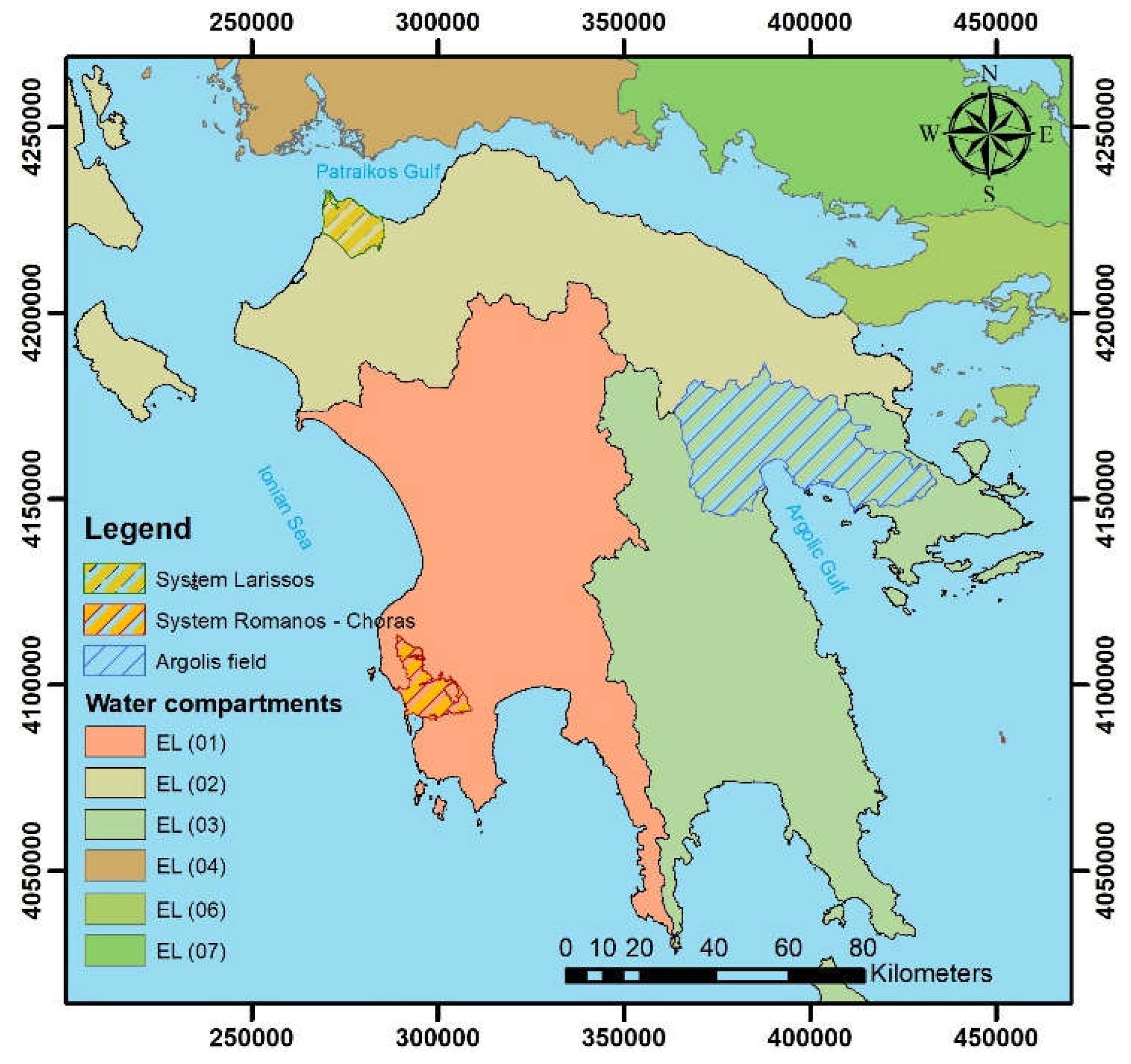
Figure 2.
Location, geology, and sampling points for the groundwater system of Larissos.

Figure 3.
Location, geology, and sampling points for the Argolis field.
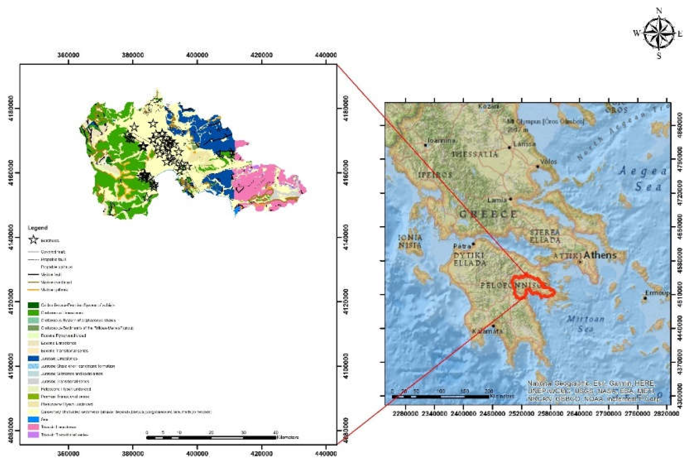
Figure 4.
Location, geology, and sampling points for the groundwater system of Romanos - Choras.
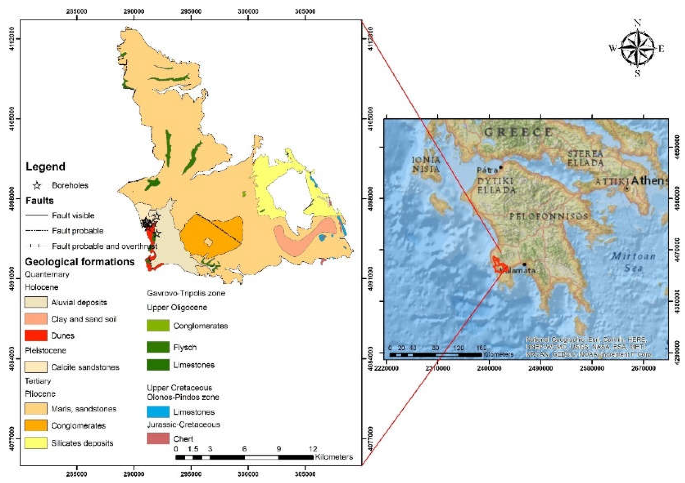
Figure 5.
Hydrochemical relationships between selected ions: (a)Na vs Cl; (b) Ca vs Cl; (c) SO4 vs Cl; (d) K vs Cl; (e) Mg vs Cl; (f) SO4 vs Ca. The line (black) is the theoretical mixing line freshwater- seawater (FW-SW).
Figure 5.
Hydrochemical relationships between selected ions: (a)Na vs Cl; (b) Ca vs Cl; (c) SO4 vs Cl; (d) K vs Cl; (e) Mg vs Cl; (f) SO4 vs Ca. The line (black) is the theoretical mixing line freshwater- seawater (FW-SW).
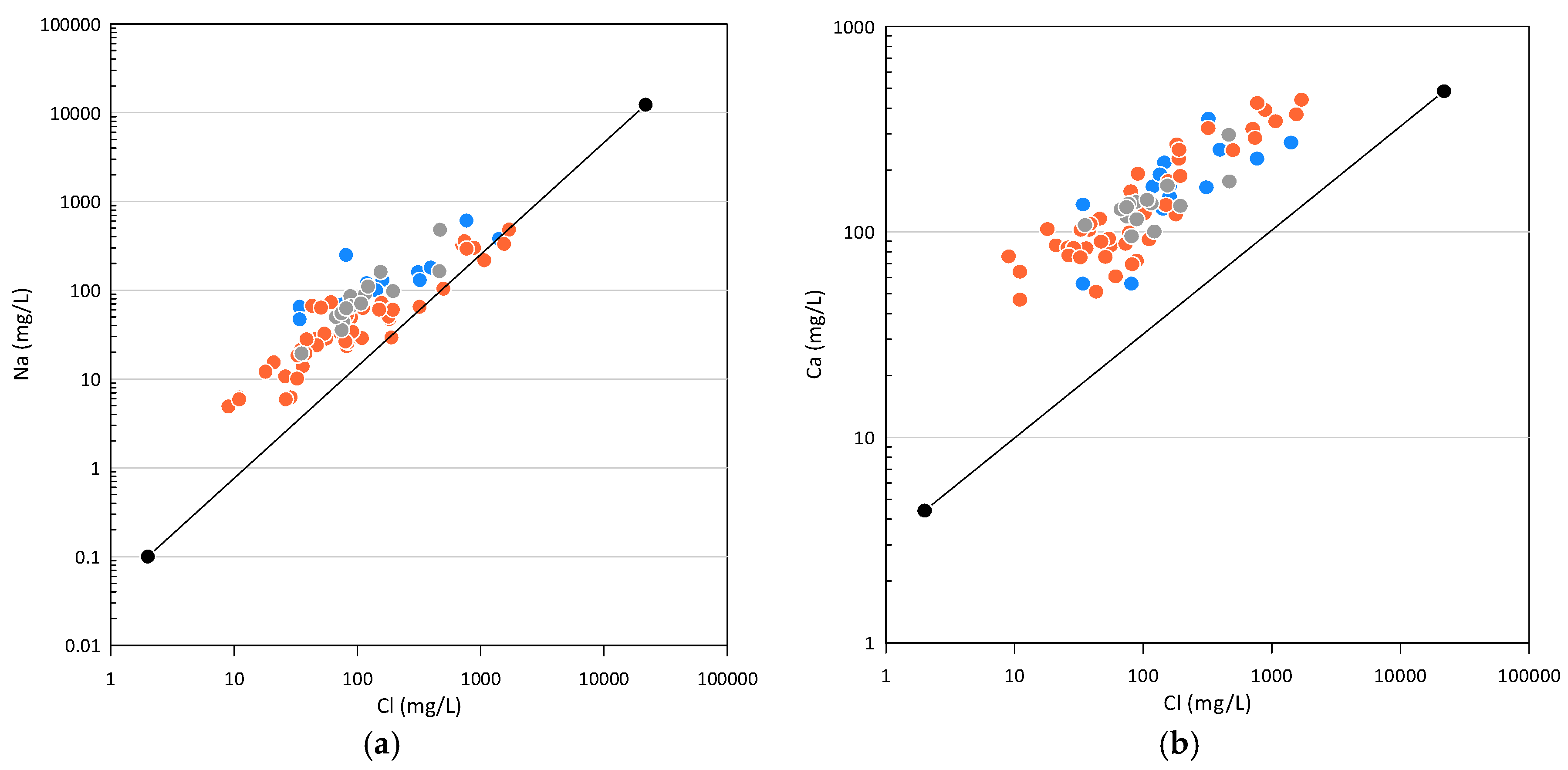
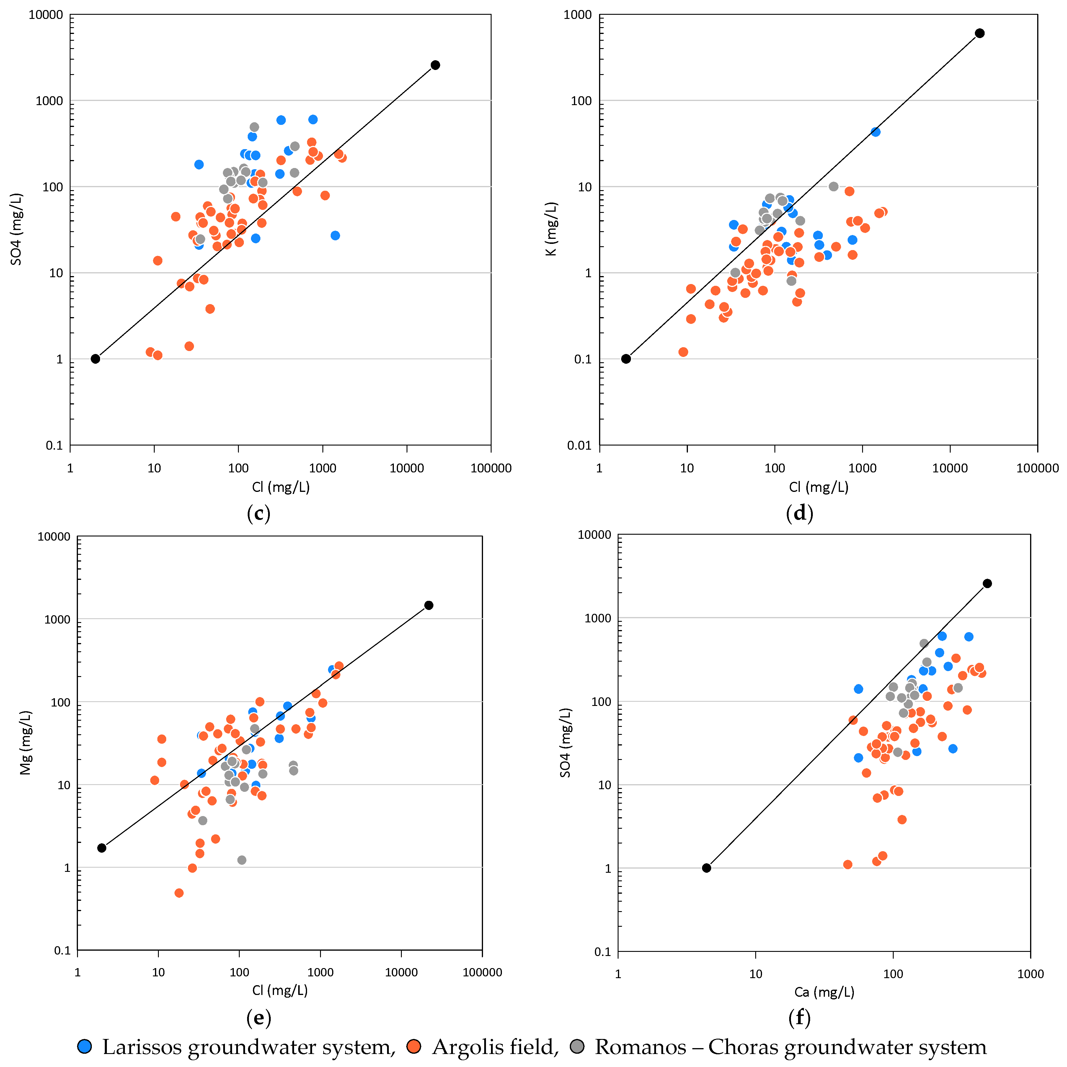
Figure 6.
Hydrochemical ratios for selected ions: (a) Mg/Ca vs Cl; (b) Na/Cl vs Cl; (c) SO4/Cl vs Cl; (d) Ca/SO4 vs Cl.
Figure 6.
Hydrochemical ratios for selected ions: (a) Mg/Ca vs Cl; (b) Na/Cl vs Cl; (c) SO4/Cl vs Cl; (d) Ca/SO4 vs Cl.
Figure 7.
Piper diagram for the three groundwater systems.
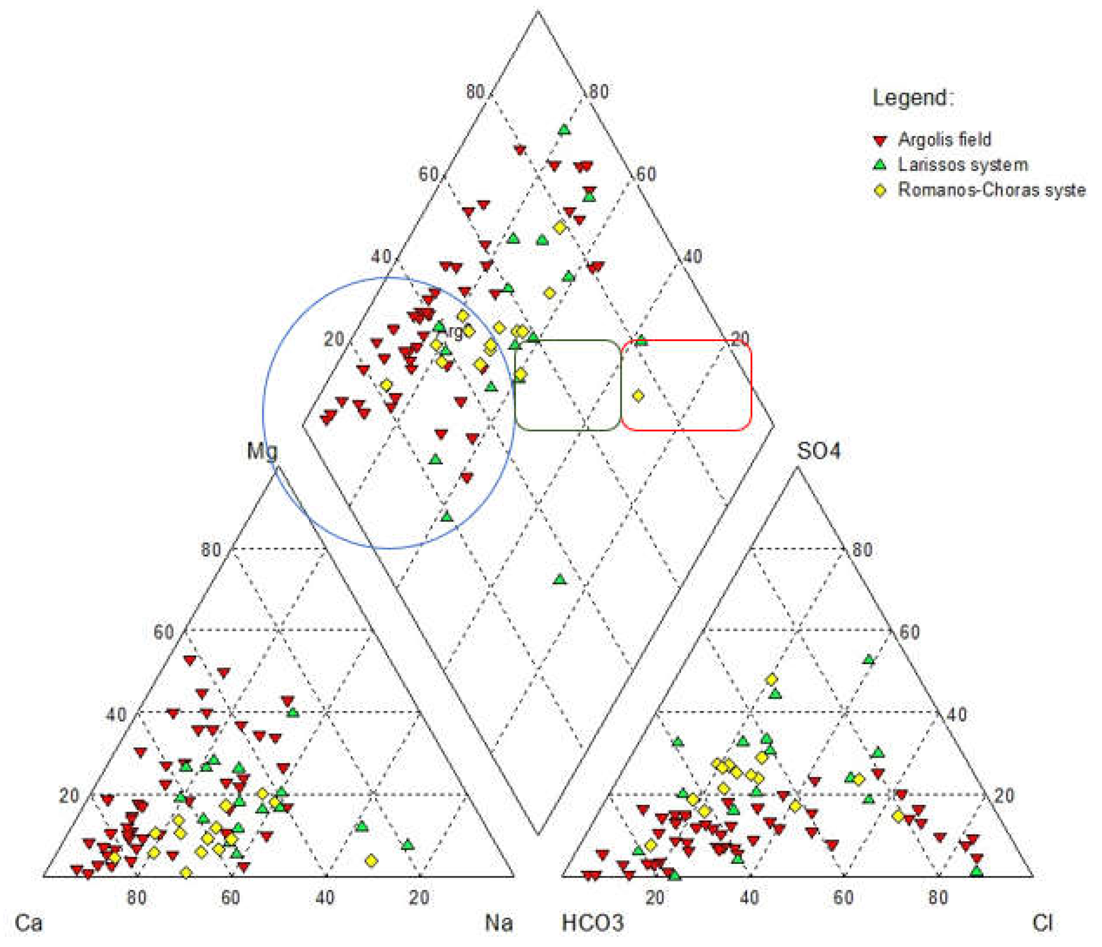
Figure 8.
Gibbs diagram for the three groundwater systems.
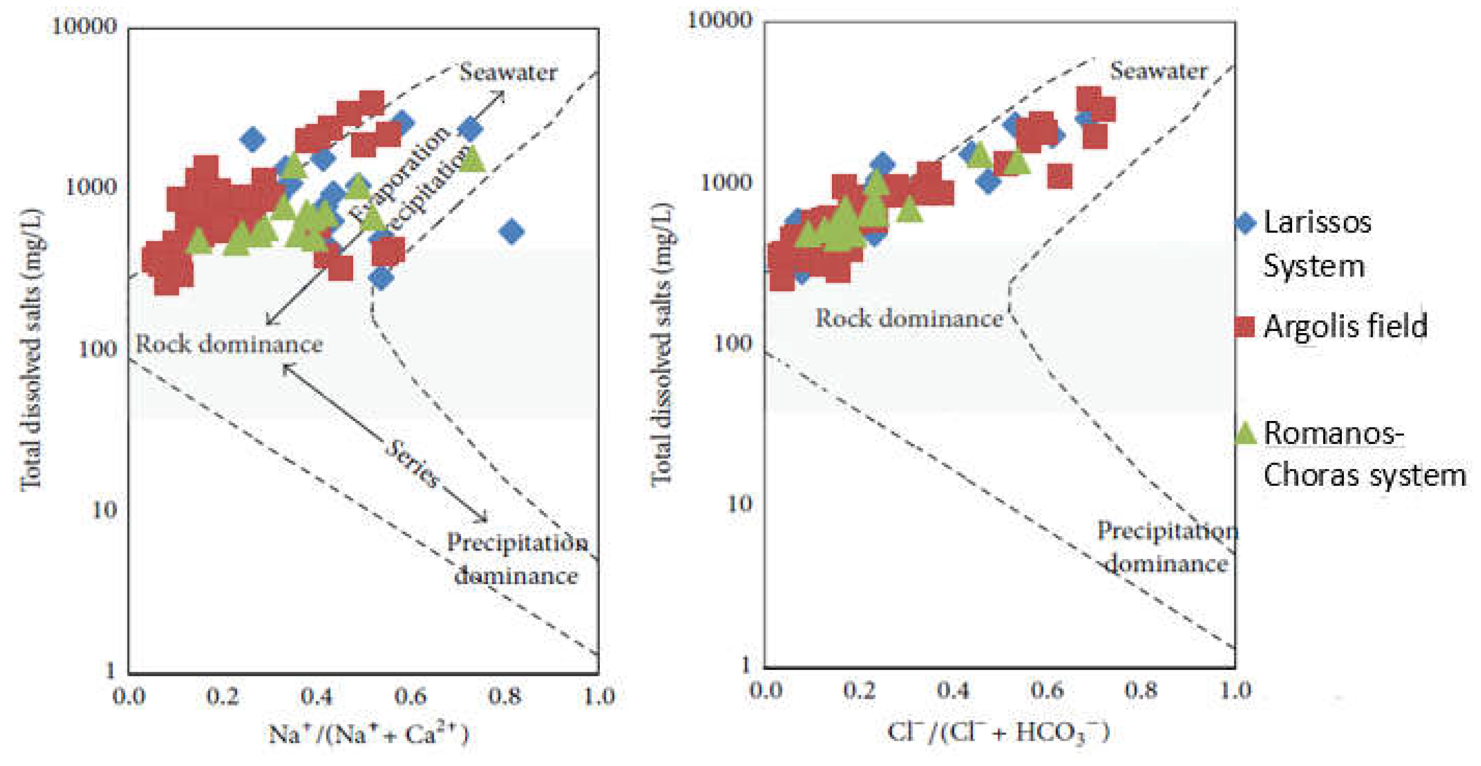
Figure 9.
Boxplots of main cations and anions for the three groundwater systems.
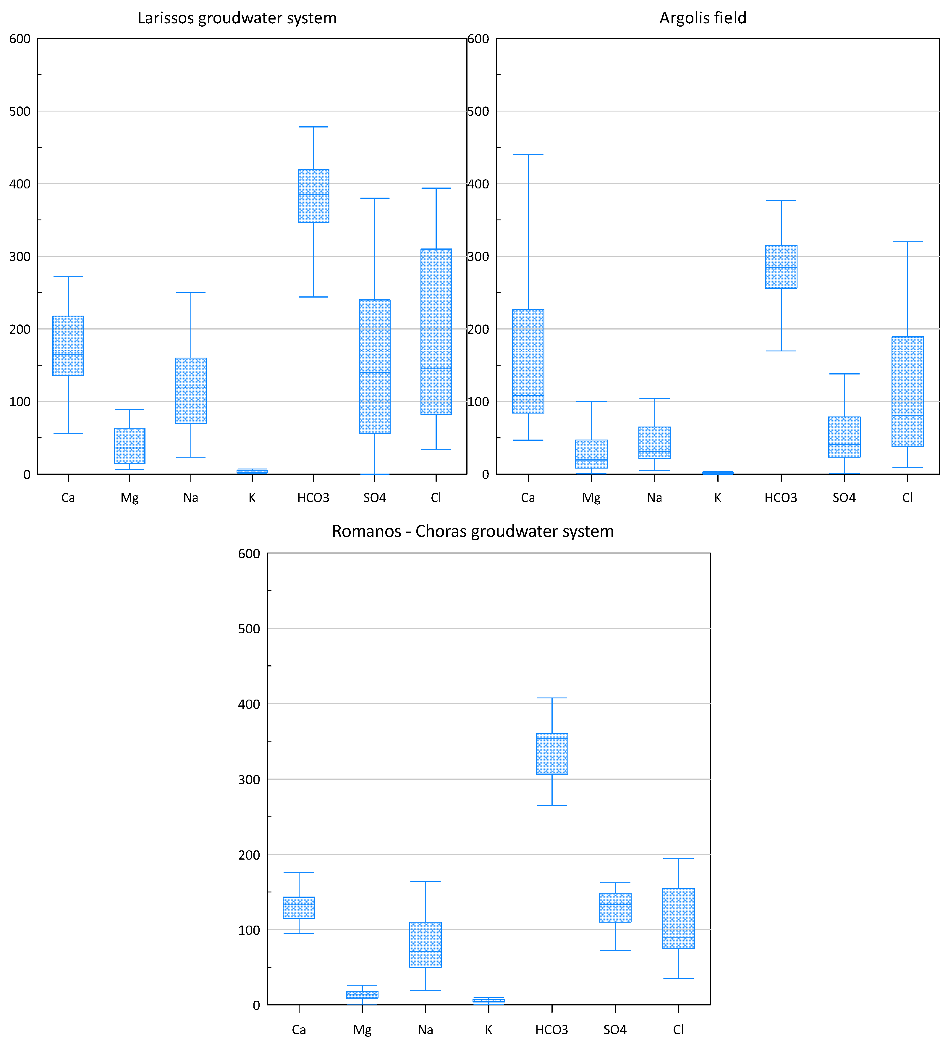
Figure 10.
Saturation indexes for calcite, dolomite, aragonite, and halite versus Cl (mg/L).
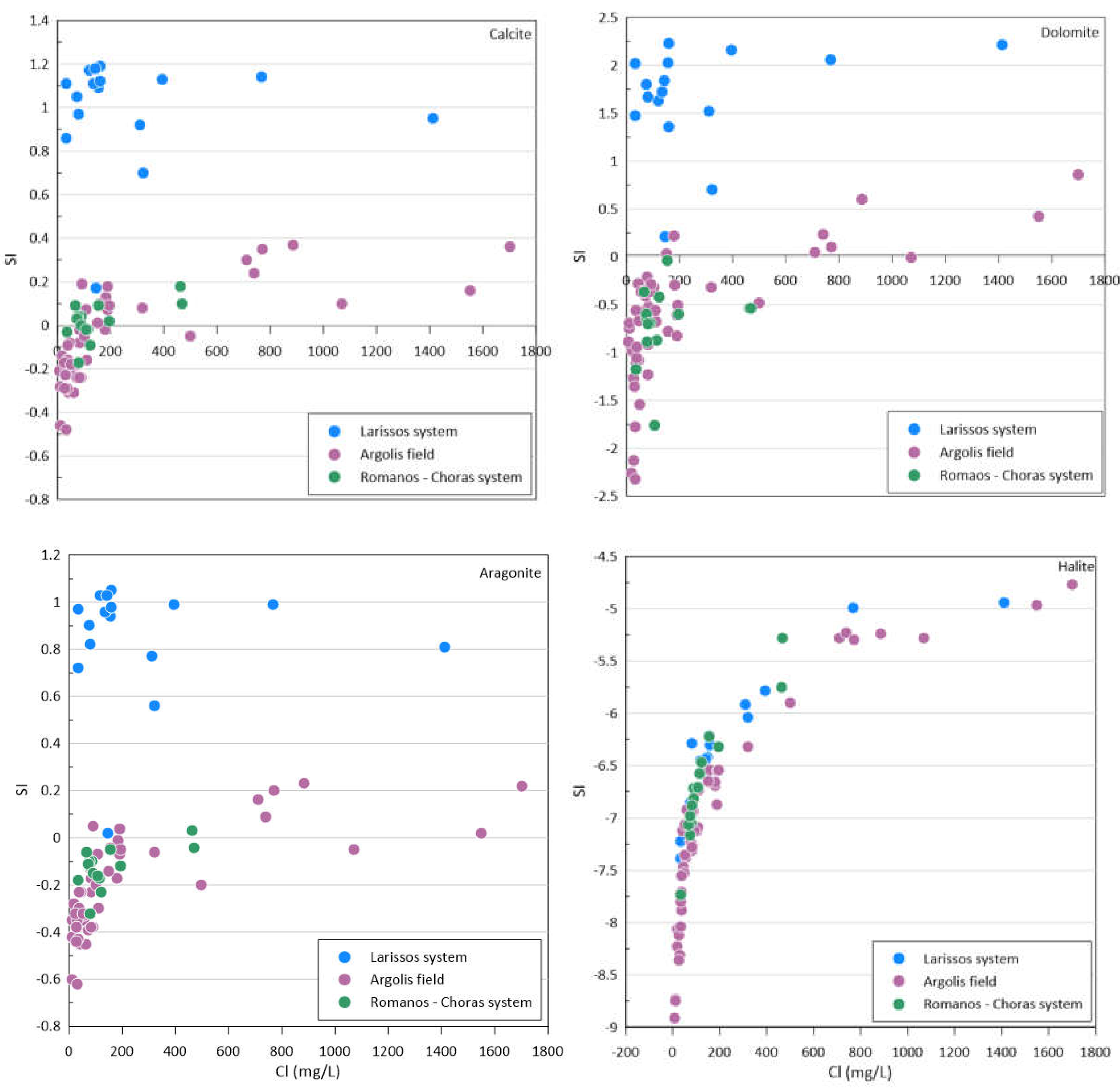
Figure 11.
Rating maps of the factor G; (a) Groundwater system of Larisssos, (b) Groundwater system of Romanos – Choras, (c) Groundwater system of Argolis field.
Figure 11.
Rating maps of the factor G; (a) Groundwater system of Larisssos, (b) Groundwater system of Romanos – Choras, (c) Groundwater system of Argolis field.
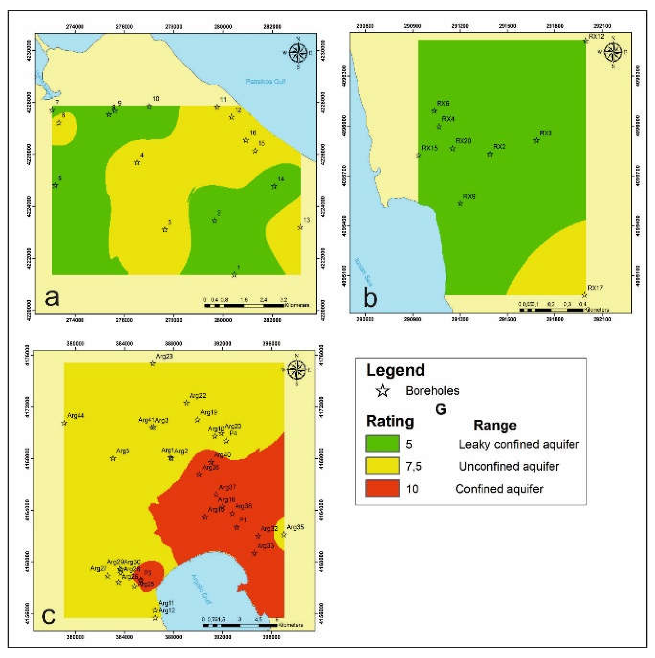
Figure 12.
Rating maps of the factor A; (a) Groundwater system of Larisssos, (b) Groundwater system of Romanos – Choras, (c) Groundwater system of Argolis field.
Figure 12.
Rating maps of the factor A; (a) Groundwater system of Larisssos, (b) Groundwater system of Romanos – Choras, (c) Groundwater system of Argolis field.
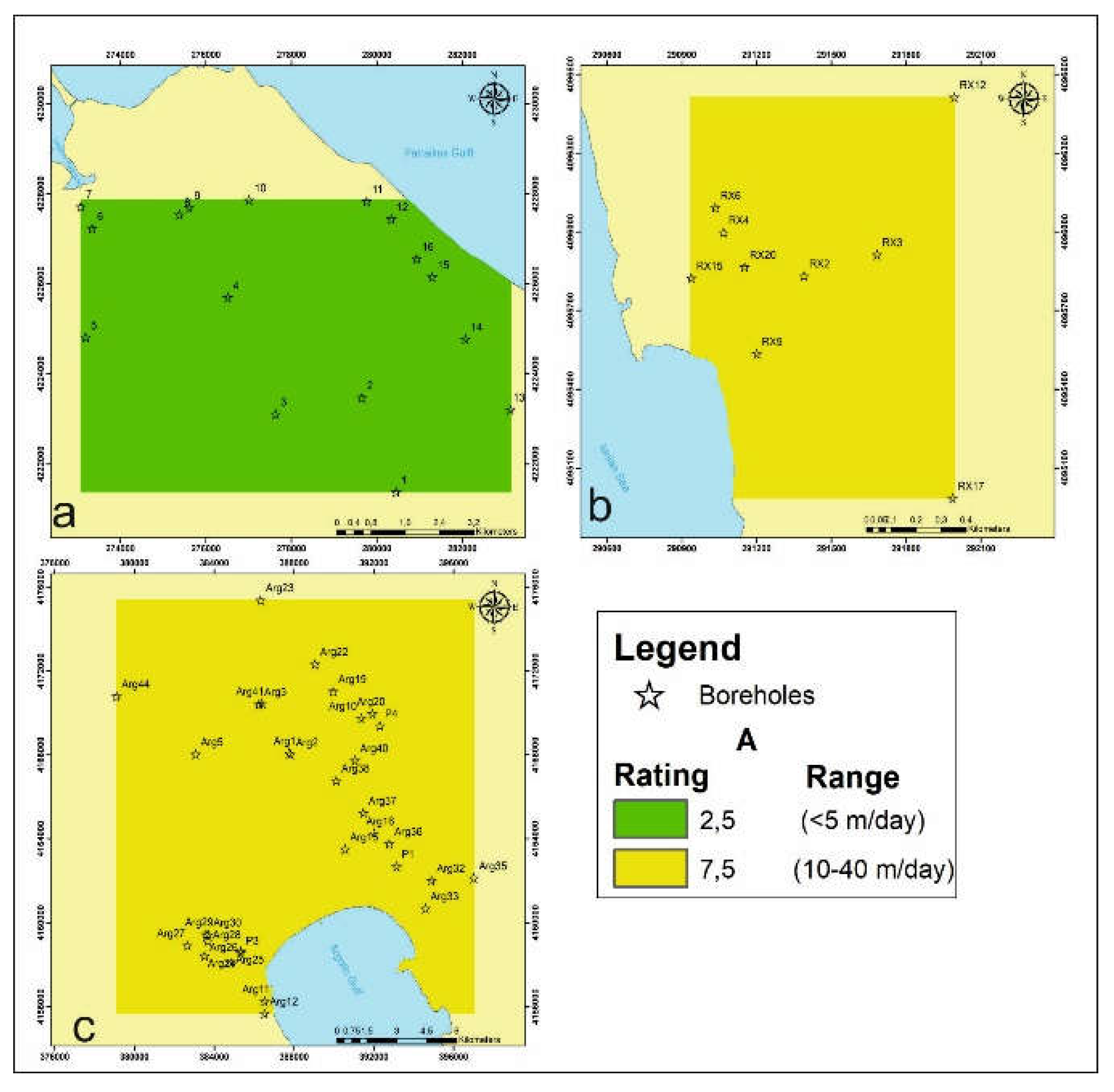
Figure 13.
Rating maps of the factor L; (a) Groundwater system of Larisssos, (b) Groundwater system of Romanos – Choras, (c) Groundwater system of Argolis field.
Figure 13.
Rating maps of the factor L; (a) Groundwater system of Larisssos, (b) Groundwater system of Romanos – Choras, (c) Groundwater system of Argolis field.
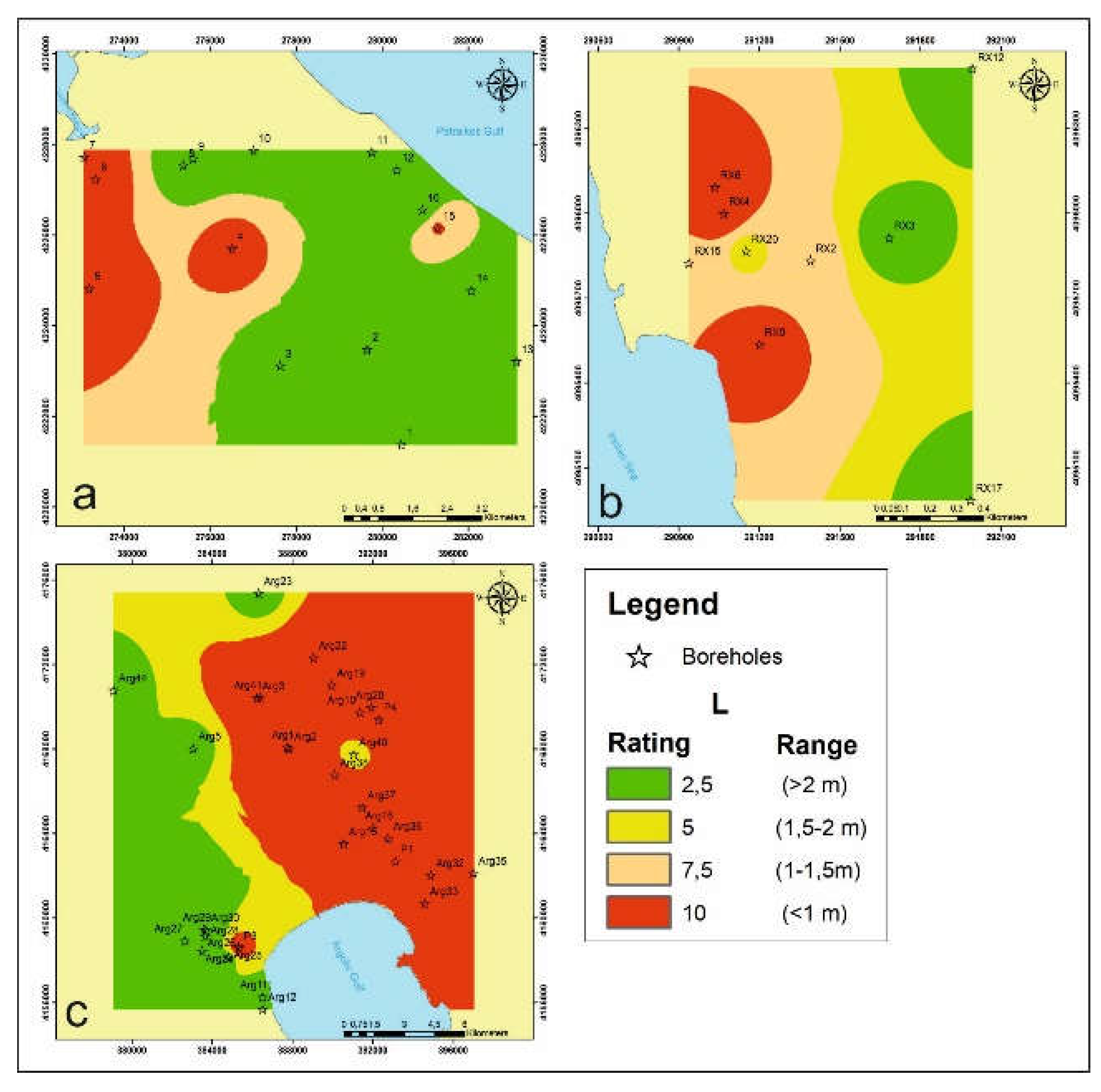
Figure 14.
Rating maps of the factor D; (a) Groundwater system of Larisssos, (b) Groundwater system of Romanos – Choras, (c) Groundwater system of Argolis field.
Figure 14.
Rating maps of the factor D; (a) Groundwater system of Larisssos, (b) Groundwater system of Romanos – Choras, (c) Groundwater system of Argolis field.
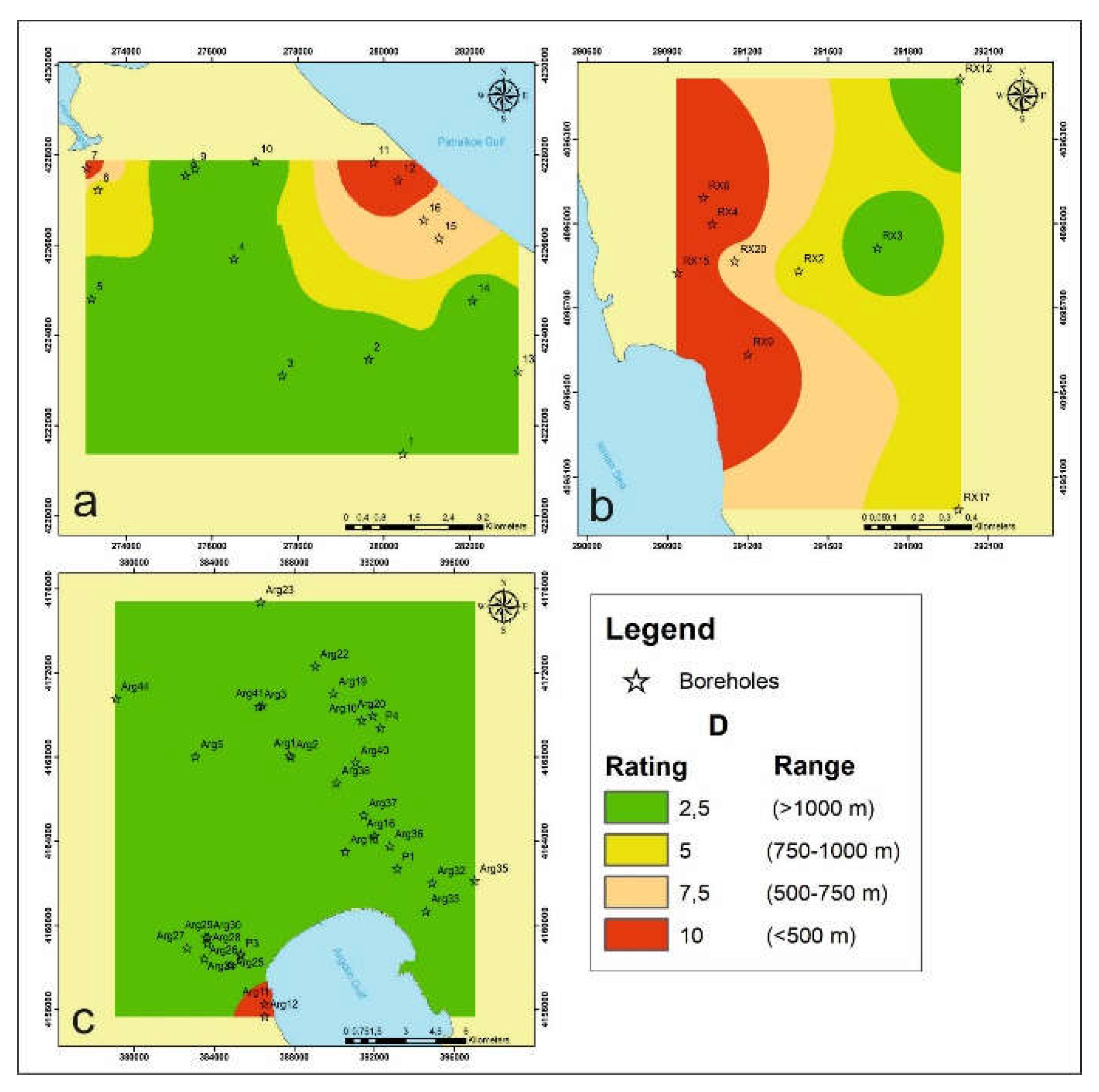
Figure 15.
Rating maps of the factor I; (a) Groundwater system of Larisssos, (b) Groundwater system of Romanos – Choras, (c) Groundwater system of Argolis field.
Figure 15.
Rating maps of the factor I; (a) Groundwater system of Larisssos, (b) Groundwater system of Romanos – Choras, (c) Groundwater system of Argolis field.
Figure 16.
Rating maps of the factor T; (a) Groundwater system of Larisssos, (b) Groundwater system of Romanos – Choras, (c) Groundwater system of Argolis field.
Figure 16.
Rating maps of the factor T; (a) Groundwater system of Larisssos, (b) Groundwater system of Romanos – Choras, (c) Groundwater system of Argolis field.
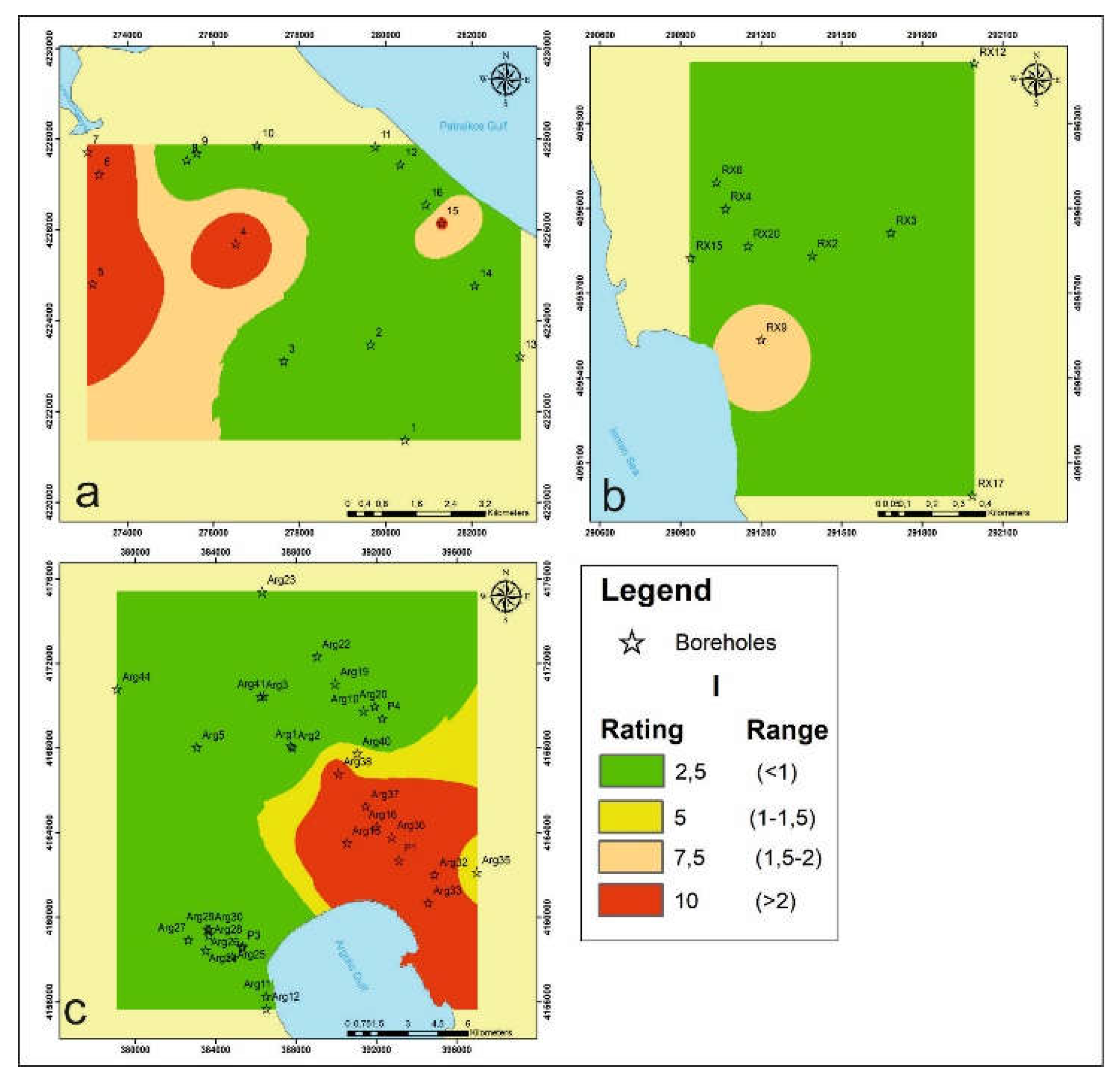
Figure 17.
(a) GALDIT vulnerability model in groundwater system of Larissos system; (b) GALDIT vulnerability model in groundwater system of Romanou – Choras. (c) GALDIT vulnerability model in Argolis field.
Figure 17.
(a) GALDIT vulnerability model in groundwater system of Larissos system; (b) GALDIT vulnerability model in groundwater system of Romanou – Choras. (c) GALDIT vulnerability model in Argolis field.
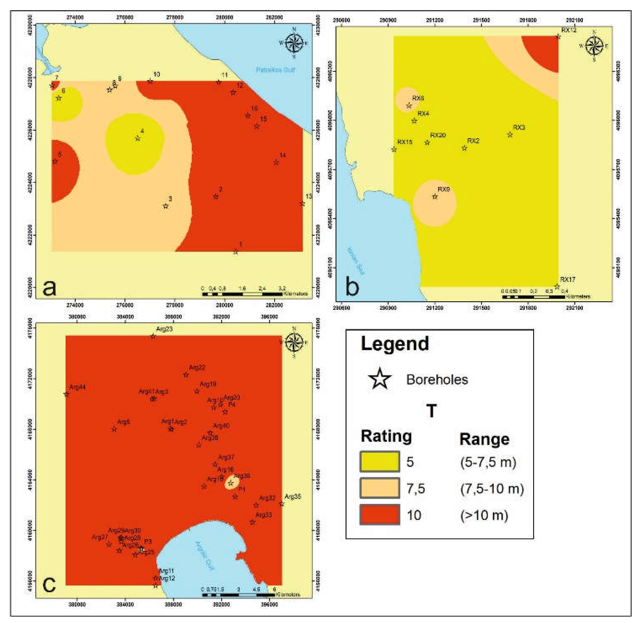
Figure 18.
Impact of seawater intrusion using two parameters EC and Cl/SO4 index with the map of GALDIT method in Larissos groundwater system
Figure 18.
Impact of seawater intrusion using two parameters EC and Cl/SO4 index with the map of GALDIT method in Larissos groundwater system
Figure 19.
Impact of seawater intrusion using two parameters EC and Cl/SO4 index with the map of GALDIT method in Romanos - Choras groundwater system.
Figure 19.
Impact of seawater intrusion using two parameters EC and Cl/SO4 index with the map of GALDIT method in Romanos - Choras groundwater system.
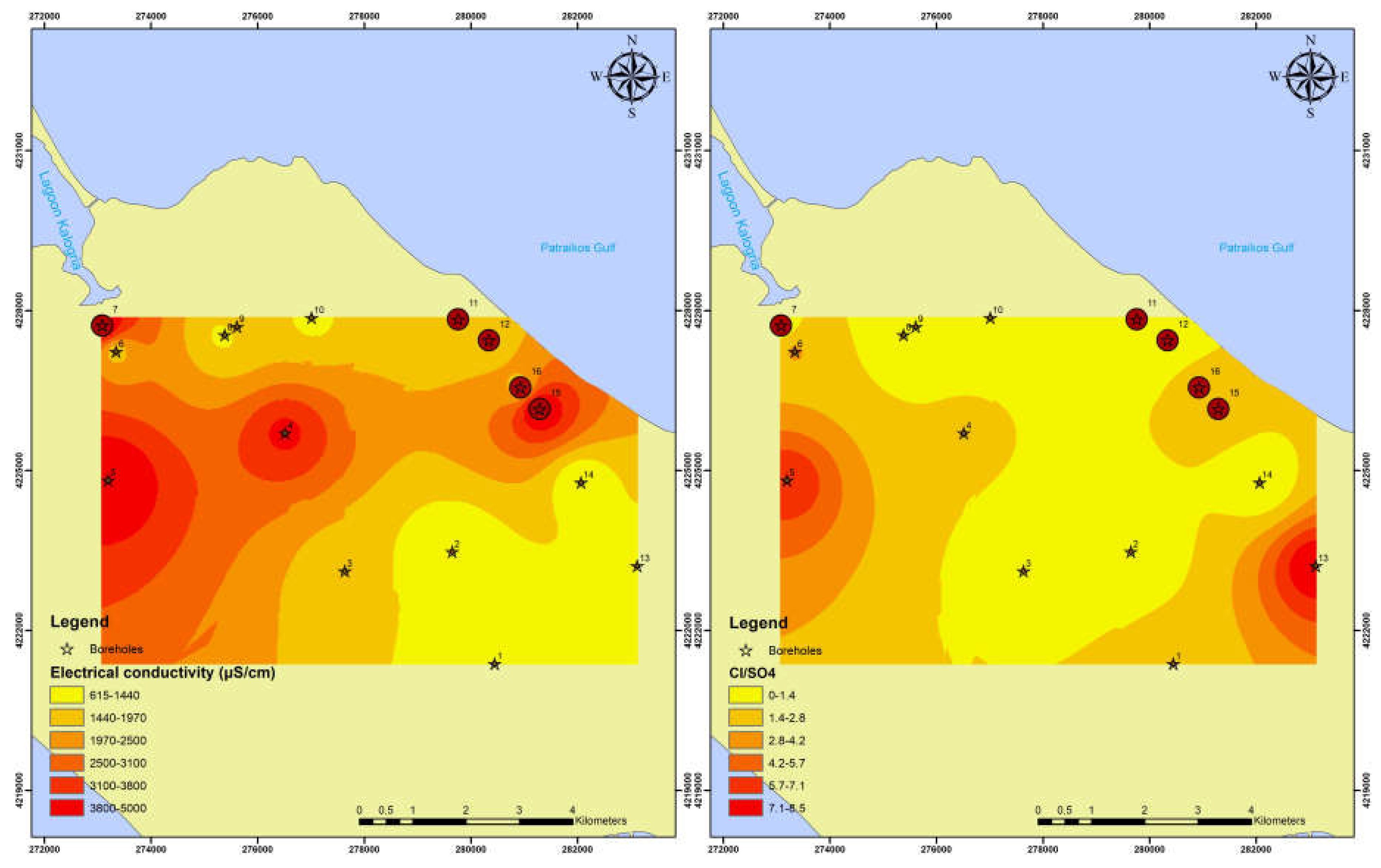
Figure 20.
Impact of seawater intrusion using two parameters EC and Cl/SO4 index with the map of GALDIT method in Argolis field.
Figure 20.
Impact of seawater intrusion using two parameters EC and Cl/SO4 index with the map of GALDIT method in Argolis field.
Disclaimer/Publisher’s Note: The statements, opinions and data contained in all publications are solely those of the individual author(s) and contributor(s) and not of MDPI and/or the editor(s). MDPI and/or the editor(s) disclaim responsibility for any injury to people or property resulting from any ideas, methods, instructions or products referred to in the content. |
© 2024 by the authors. Licensee MDPI, Basel, Switzerland. This article is an open access article distributed under the terms and conditions of the Creative Commons Attribution (CC BY) license (http://creativecommons.org/licenses/by/4.0/).
Copyright: This open access article is published under a Creative Commons CC BY 4.0 license, which permit the free download, distribution, and reuse, provided that the author and preprint are cited in any reuse.


