1. Introduction
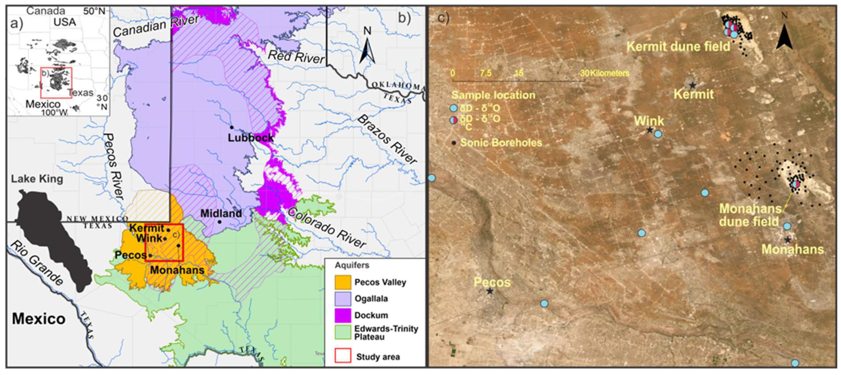
The Chihuahuan Desert in west Texas with distinctive active and tall dune fields and the widespread occurrence of sand sheets is one the most arid areas on the Southern High Plains (SHP) USA (
Figure 1) [
1,
2,
3,
4]. Aridity has intensified in the late 20th and 21st centuries with a 10 to 50% decline in precipitation since 1979 [
5,
6,
7,
8,
9]. This drying is regional with extended periods of stream intermittency with common no-flow conditions for tributary and major rivers concomitant with increased freshwater demand and decreased reservoir and groundwater storage [
10,
11,
12,
13]. A clear indication of current water supply limitations on the SHP is declining groundwater levels by up to 100 cm/yr. in the past seventy years for major aquifers, such as the Ogallala, Pecos Valley, Dockum and Edwards-Trinity Plateau [
14,
15,
16,
17,
18,
19,
20]. Groundwater supply is predicted to decrease further by nearly 30% on the SHP with potentially higher drought frequency and intensity in the mid to late 21st century, which may have a detrimental impact on nearby cities and agricultural and energy production [
21,
22,
23].
The recharge for aquifers on the SHP occurs from precipitation, irrigation seepage, and cross-formational flow amongst aquifers [
14,
24,
25,
26]. Direct precipitation accounts for 1 to 8 % of the yearly contributions of aquifer volume in the arid areas, like The Pecos Valley Aquifer (PVA) in the Chihuahuan Desert of west Texas [
27]. The PVA receives approximately 50% of yearly recharge, a volume of 55 x106 m3 water, from cross flow from the Ogallala, Edward-Trinity Plateau, and Dockum aquifers. [
26,
27,
28] However, additional recharge area may be afforded by unknown groundwater systems in the extensive dunes and sand sheets on the SHP [
29,
30].
Tall and extensive dune systems, including ergs, often host extensive aquifers or constitute preferential recharge pathways to unconfined aquifers [
29,
30]. Unsaturated-flow models dependent on antecedent conditions indicate that up to ~ 36 % of precipitation on unvegetated sand may directly recharge underlying unconfined aquifers [
31,
32]. Sand dunes and inter- and extra-dunal sand sheets with sparse vegetation often have relatively high infiltration rates >250 mm/hr. which can convey water directly to an aquifer, limiting loss from evapotranspiration [
1,
2,
29,
31]. For example, the Badain Jaran Desert in China features the tallest dunes on Earth and hosts up to seventy-two groundwater-fed interdunal lakes [
30,
33,
34,
35,
36]. The height, stability, and persistence of this Late Quaternary inland dune field may reflect a progressively rising groundwater table with ample supply and availability of aeolian sand [
30]. The source of aquifer recharge for an extensive dune field in the Taklamakan Desert, China, is inferred to be principally from snowmelt infiltration into the dunes [
37,
38]. Other tall active dunes such as The Great Sand Dunes National Monument, Colorado, USA, near fluvial sand sources, show periodic interdunal wetlands reflecting an elevated water table, recharged mostly by snowmelt seeping through the dunes [
39,
40,
41]. Also, the Nebraska Sand Hills, USA, a mostly vegetated and stabilized late Quaternary dune system, hosts numerous groundwater and precipitation-fed lakes and rivers and deranged drainages from dune-migration blockage [
42,
43,
44]. This paleo-erg shows the prominence of an elevated water table, which has dampened response to historic droughts, such as the 1930s Dust Bowl Drought [
45,
46]. In contrast, aeolian systems in the Saharan, Sinai, and Negev deserts overlay the regional Nubian Sandstone Aquifer and other shallow Quaternary aquifers that are partially unconfined and receive limited recharge by infiltration from runoff and direct precipitation. This extensive aquifer system was apparently recharged during the last glacial period between ca. 14 and 50 ka [
47,
48].
This study focused on understanding perched hydrologic systems identified in large and active Monahans and Kermit dune fields situated between the Pecos River and the High Plains escarpment in the northern Chihuahuan Desert (
Figure 1). A high groundwater table and the extension of the capillary fringe zone in major dune fields act as an agent for cohesion of aeolian strata, which contributes to dune field stability, height and may aid resistance to subsequent aeolian erosion [
30,
49]. Available evidence indicates that perched aquifers exist for large dune fields, such as the Monahans and Kermit, and possibly other aeolian systems and ergs across the SHP and the Chihuahua Desert, with the Monahans system preserving surprisingly old sediments, >550 ka [
50]. Oxygen-18 and deuterium isotopes ratios were determined on groundwater from the Monahans and Kermit dune fields, the Pecos Valley Aquifer, local rainfall, and the nearby Pecos River to infer flux and water source. The 14C activity of dissolved inorganic carbon (DIC) was determined from groundwater for Kermit and Monahans dune fields and was integrated with prior data sets for SHP [
51,
52,
53] to infer the potential flow direction of groundwater and eventual mixing with the Pecos Valley Aquifer (PVA).
1.1. Hydrogeologic Setting
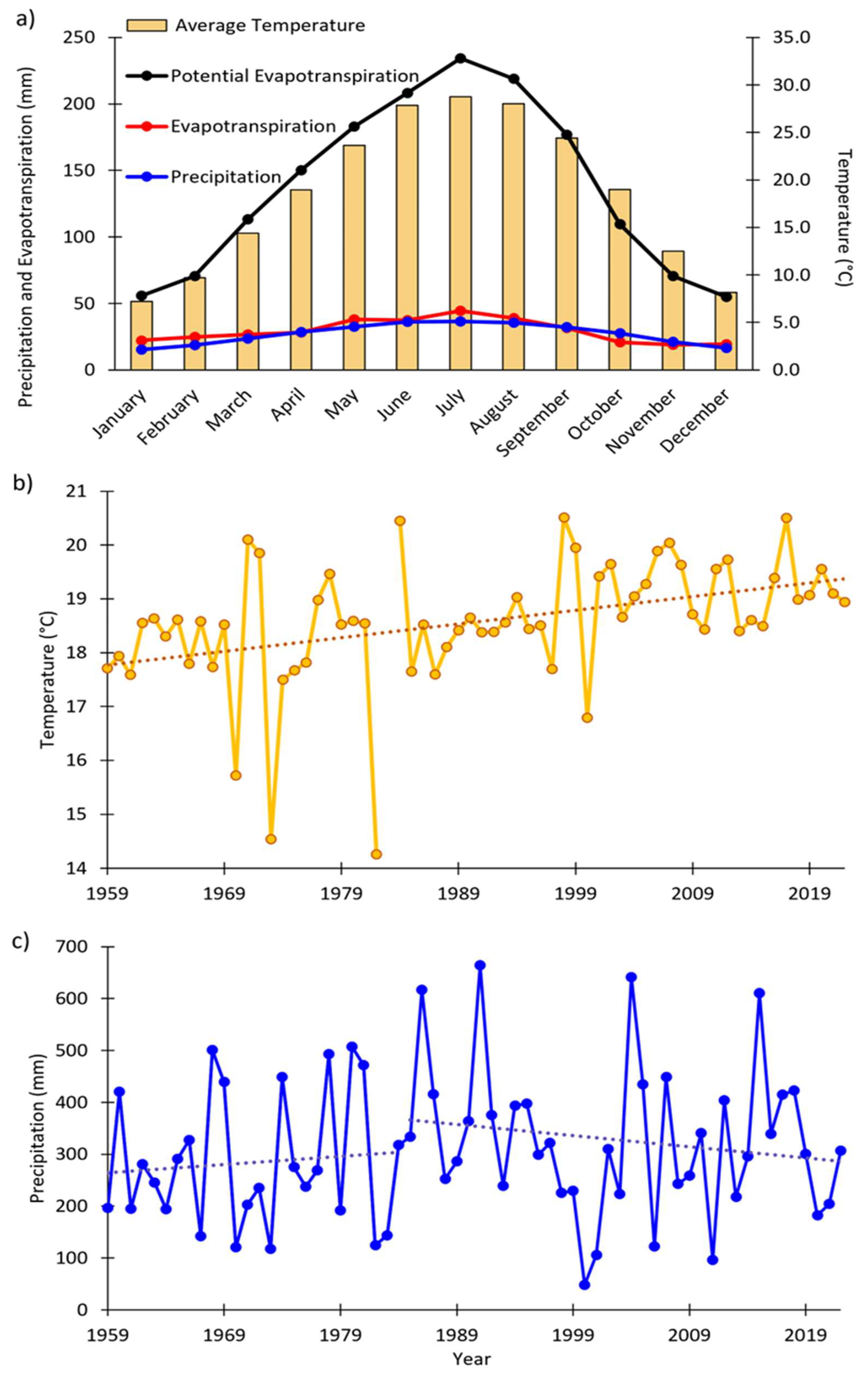
The towns of Monahans and Kermit, TX, within 15 km of the associated dune fields, have mean annual temperature (MAT) between 1959 and 2023 ~18° C, with winter and summer means of 28°C and 8.5°C, respectively [
4]. Of note is that the MAT has increased by about 2°C between 1959 and 2023 (
Figure 2). The mean annual precipitation (MAP) is ~300 mm with average annual potential evapotranspiration (ETo) of ~1800 mm between 1972 – 2024 for the nearby town of Midland [
3], and modeled evapotranspiration from Open ET [
54] ~350 mm between 2016-2023 on the Kermit and Monahans dune fields. About 70% of precipitation is delivered with thunderstorms between May and October and often coincident with peak temperatures in July and August (
Figure 2). The MAP has increased by 30% between 1959 and 1980 and subsequently decreased by 7% between 1980 and 2022 (
Figure 2). This increase in MAT and decrease in MAP in the past 40 years is consistent with aridification trends on the SHP [
5,
7].
Multiple coring and boring campaigns across the Monahans and Kermit dune fields revealed a shallow water table <1 to 10 m from the surface. On occasion, the water table coincides with the surface in interdunal areas, creating ephemeral ponds. One pond in the Monahans State Park persisted for several years in the 1980s [
20,
55,
56,
57].
The Pecos Valley Aquifer (PVA) is a regional groundwater resource found approximately 30 m below the Monahans and Kermit dune fields and the adjacent sand sheet area [
20,
57,
58]. This aquifer occurs within Cenozoic-age alluvium that infills two main subsurface basins, the Pecos and the Monument Draw troughs [
27]. The PVA is wholly unconfined with an inferred area of 17,700 km2, a maximum thickness of 460 m in the Pecos Trough, and a mean saturated thickness of 137 m [
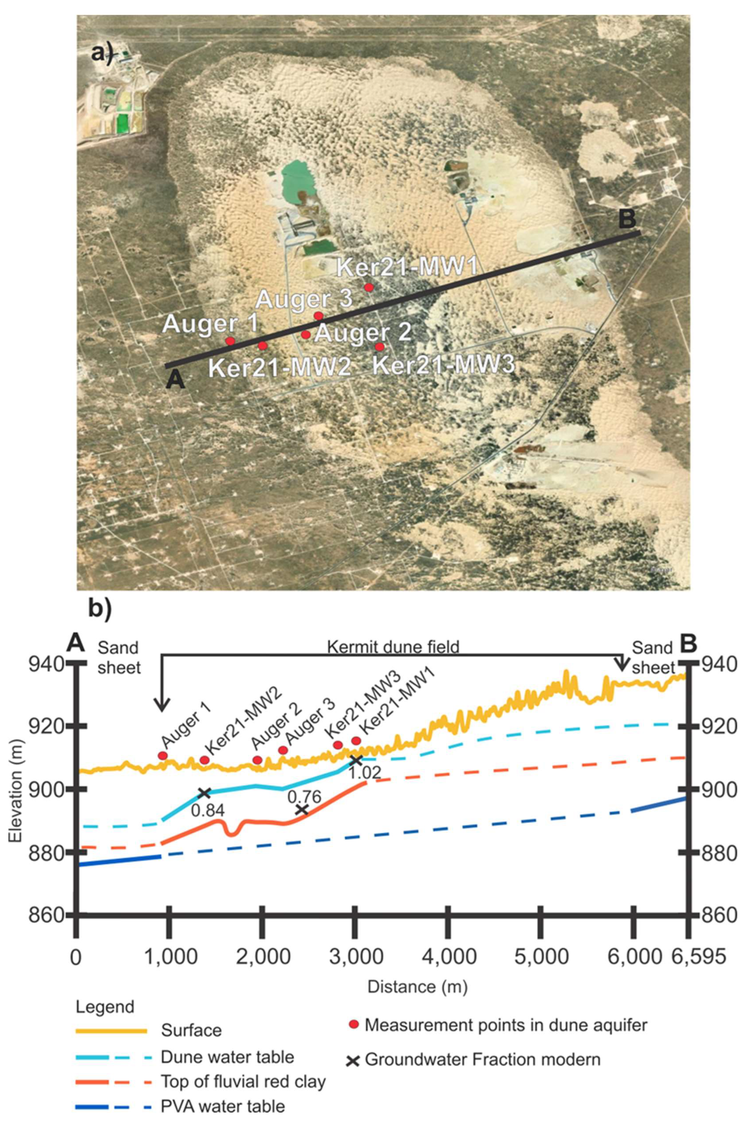
28]. The static water level ranges between 4 and 110 m for the aquifer’s southeastern part and at the Pecos Trough center, respectively. Thus, there appears to be a stratigraphic separation between the PVA and the identified perched ground water systems in the Monahans and Kermit dune fields (
Figure 3), the topic of this paper.
1.2. Geomorphic and Stratigraphic Context
The Kermit and Monahans dune fields are tall, active dune fields, rising 15 to 20 m above the surrounding sand sheet (TessaDEM 2023), limited to the east by the High Plains escarpment [
59,
60,
61]. These high dune fields show barchanoid ridges and reverse dunes, interdunal sand sheets and numerous active blow outs. Lower and central areas of the dune fields show dense vegetation cover of shrubs and grasses, that is being buried by contemporary aeolian activity. Most dune crests lack vegetation cover and actively migrate when wind speeds exceed threshold velocities of > 6 to 10 m/s [
62].
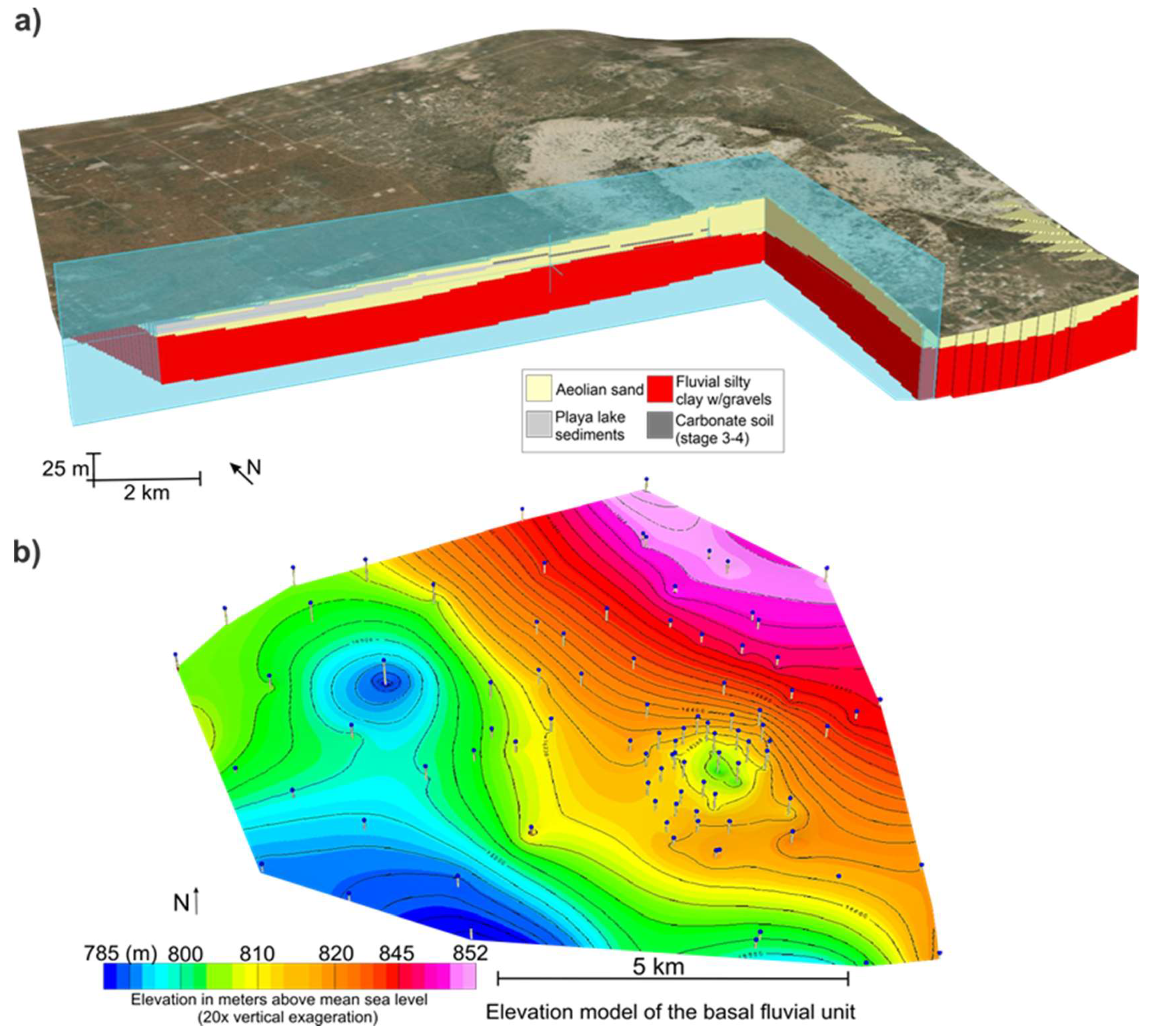
Recent sediment core-based studies and stratigraphic modeling for the Monahans dune field defined the geometry for three major aeolian chronostratigraphic units (
Figure 4;
Table S2) [
50,
63,
64], intercalated with at least six buried soils, and assumed to be broadly correlative with the Blackwater Draw Formation or time equivalents, such as the Mescalero Sands in New Mexico [
50,
65,
66]. The lowest-most unit, underlying the aeolian sand in the Monahans and Kermit dune fields, is an alluvial red gravelly clay unit, with an inferred basal age of early Pleistocene/Pliocene that reflects fluvial activity and pedogenesis prior to dune field formation [
50,
67]. This basal red clay unit, identified at depths below the Monahans and Kermit dune fields and in the nearby sand sheet area, slopes northeast to southwest with 5 to 15 m deep oval sinkhole-like features [
50,
67,
68]. Geophysical surveys of the Monahans dune field indicate a thickness of 10-15 m for this basal red clay unit [
68].
Aeolian sand deposits, intercalated with at least two paleosols, infilled sinkhole-like features within the basal red clay and buried this older surface by up to 30 m of aeolian sand. The greatest thickness of this aeolian sand coincides with the 5 to 15 m deep sinkhole like features [
67]. This complex aeolian unit has an inferred basal age of early Pleistocene, ca. 2 to 1 ma, and an upper boundary within late MOIS Stage 5, at ca. 100 to 75 ka, the latter assessment based on OSL ages [
50]. The upper limit of this aeolian complex is well demarcated by a singular or composite paleosol with stage 3 to 4 carbonate morphologies and/or argillic horizons and may be wholly or partially correlative with the Mescalero Paleosol in adjacent New Mexico [
69]. Overlying this paleosol is the youngest aeolian sand deposit with a basal age of 65 to 50 ka and includes recent late Holocene aeolian sand deposits at the surface [
50]. The basal boundary of the third unit, a medium to fine aeolian sand, is at the paleosol complex, and spans from ca. 65 ka to contemporary aeolian activity [
50].
Quaternary paleoclimatic studies indicate that the wettest conditions in the southwestern U.S has been associated with the southward expansion of the Laurentide ice sheet steering storm-tracks across the southwestern USA bringing cooler temperatures, reduced evapotranspiration and an increase in winter precipitation [
50,
70,
71,
72]. Case-in-point, a period of limited aeolian sand deposition with pronounced pedogenesis in the Monahans dune field occurred ca. 26 to 12 ka, contemporaneous with high stands of the nearby Pleistocene Lake King [
62,
67,
70]. Other potential pluvial episodes between ca. 350 and 195 ka adjacent to the Monahans dune field were identified by crayfish burrows, stromatolites, and mud cracks, and indicate hydrologic excess during an extended (> 20 ka) interglacial period, such as marine oxygen isotope stage (MOIS) 7 [
50,
73]. Recent climate modeling of warmest conditions during the last interglacial ca. 135 to 125 ka indicates a precipitation dipole with drier states in Arizona, and wetter conditions in West Texas and adjacent areas in New Mexico associated with an increased flux of low-level moisture from the Gulf of Mexico [
74]. Thus, the wettest intervals in West Texas spanning ca. 10 to 30 ka appeared to have occurred during glacial periods. However, wetter climates may have prevailed for ca. 5 to 10 ka intervals during the warmest interglacial conditions in MOIS 5, 7, 9 and 11, with an inferred strengthening of the summer monsoon, enhanced by evaporative sources from the Gulf of Mexico [
50,
74,
75,
76].
2. Materials and Methods
2.1. Stratigraphic Modeling of the Kermit Dune Field and Estimation of Recharge Contribution to the PVA
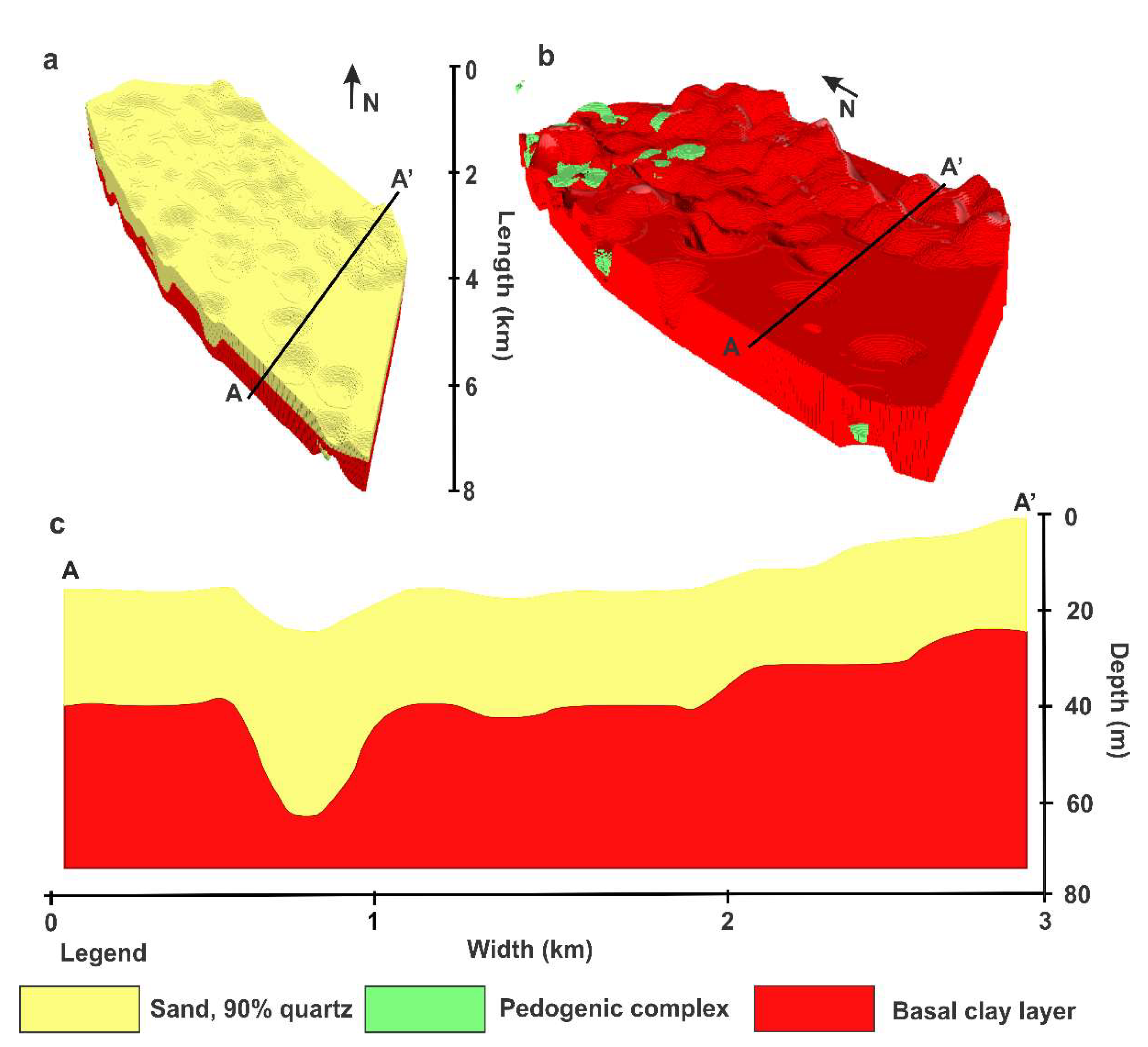
The stratigraphic architecture of the Kermit dune field was determined from data for eighty-two sonic boreholes drilled in 2017, 2018, and 2021 (
Figure 1). Most of these boreholes penetrated through the aeolian sand sequence into the basal, red gravelly-clay. The lithology of sediments retrieved by sonic drilling was continuously logged, and one author (A.F.) observed and logged sediments during active retrieval of borings in 2021. The lithologic data was separated into three units: basal alluvial clay with gravel, carbonate and clay-rich pedogenic complex, and fine to medium aeolian sands (
Figure 5). The drillers also recorded the depth to water table, which is the basis for depth inferences for the unsaturated layer, saturated layer, and the basal red clay aquitard (
Table S1). Geoprobe cores from the Monahans [
50,
64] and the Kermit dune field from this study confirm the upper lithostratigraphic units including aeolian sands and carbonate-rich pedogenic complex (
Figure 4 and
Figure 5).
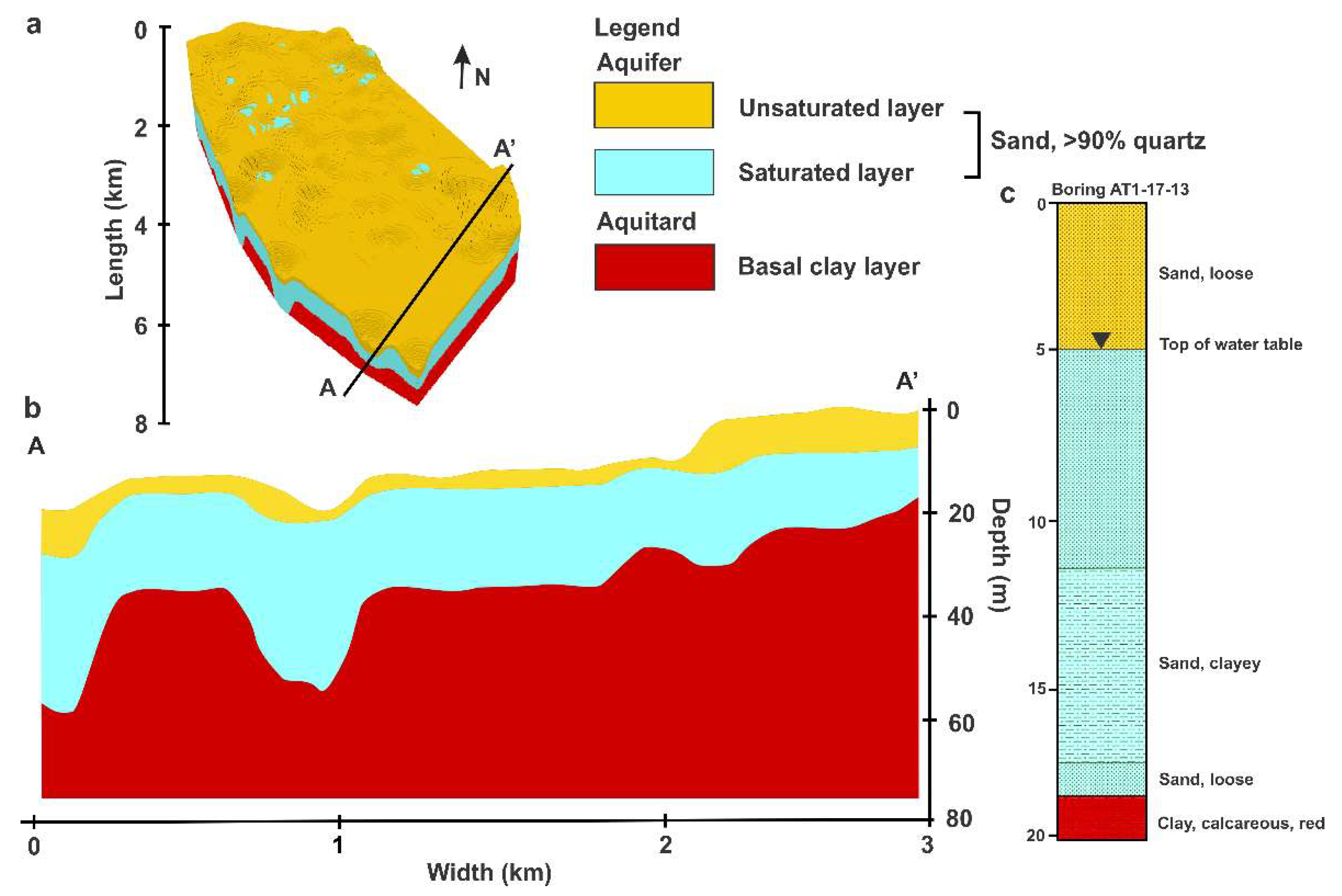
The lithostratigraphic and hydrologic data from borings and Geoprobe cores for the Kermit dune field is the basis for calculating isosurfaces and voxel-based 3D block models using Geosoft Target software (
Figure 5 and
Figure 6; Version 2021.2.1
https://www.seequent.com/products-solutions/geosoft-target/). Boreholes were georeferenced with depths determined to major composite unit contacts and boundaries, including the depth to the aeolian sand base, to the interstratified rubified, carbonate-dominated, paleosol complexes with a thickness exceeding 1 m, and to the subjacent basal red-clay alluvial deposit. Isosurfaces were produced for each unit boundary applying a minimum curvature model to interpolate amongst boreholes. A 3D visualization of the subsurface was modeled by populating the model area amongst isosurfaces with 4 m
3 voxel resolution for over 65% of the Kermit dune field (
Figure 5 and
Figure 6). Smaller voxels can yield finer resolutions, however, the use of voxels < 1 m
3 exceeds the sampling density of the minimum curvature method and may return anomalous stratigraphic associations. The distribution and density of borehole data for the Kermit dune field (
Figure 1) yields a higher resolution architectural model compared to the Monahans dune field (
Figure 4).
The recharge contribution of the Kermit and Monahans dunal aquifers to the Pecos Valley Aquifer (PVA) was evaluated according to the soil water balance method [
76] annually between 2021 and 2023:
Where,
Ri = recharge in the Pecos Valley Aquifer
P = precipitation on the Kermit dune field [
4]
Eo = actual evapotranspiration on the Kermit dune field, from Open ET [
54]
ΔW = change in soil water storage, here it corresponds to the annual water level change measured in monitoring wells 2 and 3 on the Kermit dune field [
77]
R0 = run – off. On the Kermit dune field, run-off is considered null.
The resulting recharge from the Kermit dune field to the PVA Ri is compared to the estimated total annual recharge in the PVA, 0.112 km
3 [
27,
28]. Water pumping from local mines is not publicly accessible, therefore it is assumed to be negligeable for the purpose of this study.
2.2. Chronostratigraphy of Aeolian Sands by Optically Stimulated Luminescence (OSL) Dating
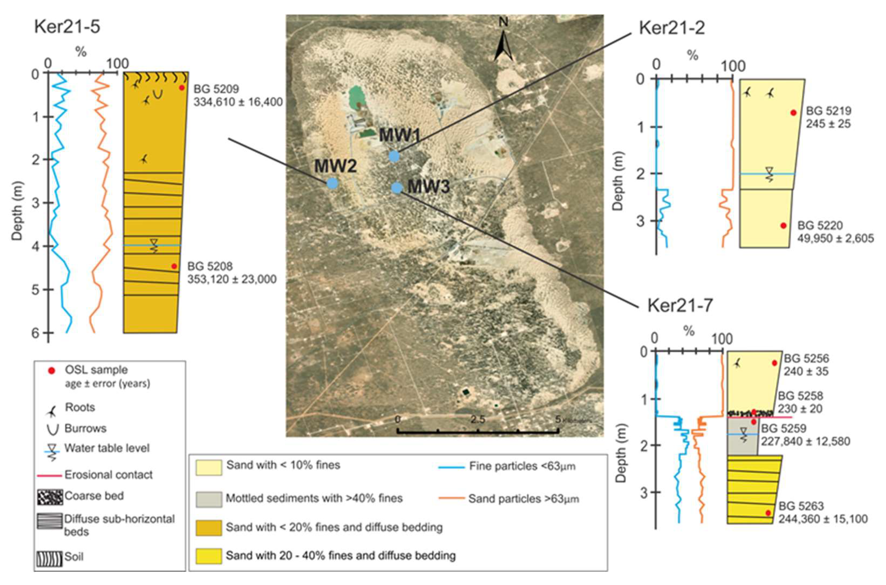
Three Geoprobe cores of sediment, Ker21-2, Ker21-5, and Ker21-7 (
Figure 7), from monitoring well locations 1, 2, and 3, were retrieved from the Kermit dune field. These cores were logged for sedimentologic and pedologic details, including Munsell colors to discern lithologic units. In turn, the cores were analyzed for granulometry by a Malvern Mastersizer 3000 (
Figure 7). Age of lithologic units are provided by optically stimulated luminescence (OSL) dating using single aliquot regeneration (SAR) and thermal transfer (TT) protocols on quartz grains size 150-250 μm, following analytical approaches of Forman et al. [
50].
2.3. Deuterium and Oxygen Isotopic Analysis of Ground and Surface Waters
The deuterium (2H/1H) and oxygen (
18O/
16O) isotopic ratios were determined for forty-three water samples at the Stable Isotope Laboratory, Baylor University. Specifically, multiple water samples were taken from three monitoring wells in the Kermit dune field, thirteen water production wells associated with proppant mining at Atlas Energy Solutions’ Kermit and Monahans facilities, three local rainwater events, two public-use wells in the nearby towns of Monahans and Wink, TX, and the Pecos River near Grandfalls, Mentone, and Pecos, TX (
Figure 1). Samples were collected carefully into 10 mL vials with the vials filled after triplicate overflow and sealed with no air gap. The vials were kept in an ice chest prior to analyses to avoid evaporation. The resultant δD vs δ
18O isotopic ratios for aquifers associated with Kermit and Monahans dune fields were compared to the global meteoritic water line [
78,
79,
80], and pre-existing isotopic data for the Pecos Valley Aquifer [
53], the Pecos River [
52], and the Chihuahua Desert [
51], to investigate the potential sources of water, mixing and derivations (
Table S3).
2.4. Determining Radiocarbon Activity of Groundwater
Three water samples from the Kermit dune field and one from the Monahans dune field (
Figure 1) were analyzed for radiocarbon activity or Fraction modern (Fm) on dissolved inorganic carbon (DIC) at the National Ocean Sciences Accelerator Mass Spectrometry (NOSAMS) facility at the Woods Hole Oceanographic Institution (WHOI), MA. Samples were collected in 1 L Nalgene bottles, filled after triplicate overflow, sealed with no air gap, and stored in an ice chest. The spatial variation of apparent DIC
14C activity for the Kermit and Monahans dune field was compared to previously acquired 14C DIC for the Pecos Valley Aquifer [
53] to evaluate spatial variations in
14C DIC activity and infer recharge and flow patterns. Older sources of DIC (> 100 ka old) within the stratigraphy of these dune fields such as CaCO
3-bearing playa lake sediments and paleosols [
50,
77] may exchange with groundwater and artificially increase the apparent ages [
81].
3. Results
3.1. Internal Structure of the Kermit and Monahans Dune Fields
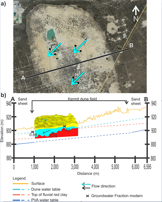
The 3D model of the Kermit dune field’s stratigraphic architecture (
Figure 5) highlights stratigraphic similarities with the Monahans dune field, 30 km to the south [
50,
64] (
Figure 1). The base of the stratigraphic model is the clay-rich, gravelly red alluvial unit identified in most boreholes, which slopes towards the southwest with a gradient of 3.5 m/km. At least five, 5 to 15 m deep, closed oval depressions were identified within the surface of the basal red clay, and may be sinkhole-like features, possibly associated with dissolution of deeper Permian evaporites [
82,
83,
84]. There is no indication of these closed depressions in the present topography of the Kermit and Monahan dune fields [
50]. Indeed, the thickest occurrence (> 30 m) of aeolian sands coincide with these closed depressions. Interstratified pedogenic complexes occur in upper 10 to 15 m of the aeolian sand and appear subparallel to the present topography. These buried soil complexes are identified in the northwestern part of the Kermit dune field, though less prominent than in the Monahans dune field [
50].
Most borehole logs record the depth to the water table in the Kermit dune field, which is the basis for a simplified 3D-model of the saturated zone with an area of ~23 km
2 (
Figure 6). The top of the saturated zone appears to be broadly subparallel with the basal red clay aquitard, and groundwater flows apparently from northeast to southwest with a gradient of 8 m/km, which increases toward the steep, western edge of the dune field. The saturated zone for model calculation for this study occurs in a relatively homogeneous well-sorted medium to fine sand with a porosity of ~30 % [
29]. The total estimated volume of the saturated layer for the Kermit dune field is ~0.22 km
3 derived from this model. The groundwater estimated volume of the Kermit and Monahans dune fields is 0.13 km
3 and 0.19 km
3 respectively, derived from the simplified model representation of the stratigraphy and groundwater table.
3.2. Chronostratigraphy of the Kermit Dune Field
Sediment core, Ker21-7, from monitoring well 3 site contains a discontinuous but significant record on past variability in environmental conditions (
Figure 7,
Table 1). A conspicuous 1 m-thick grey, mottled older sandy loam deposit, containing >30% fines, with a bounding TT-OSL age of ca. 227 ± 12.6 ka (BG5259), occurs at 1.33 m depth in this core and is interpreted as an ephemeral interdunal lake deposit. The OSL age for this inferred interdunal sediments in the Kermit dune field is correlative to a pluvial lake interval documented at the margin of the Monahans dune field bounded by TT-OSL ages of 233 ± 14.5 ka (BG4765TT) and 196 ± 10.9 ka (BG4761TT) [
50]. The lacustrine sediments in the Kermit dune field were eroded and truncated by emplacement of near surface well-sorted aeolian sand, with < 5% fines and quartz grains yielded an OSL age of 230 ± 20 yr. (BG5258).
Sediment core, Ker21-2, from monitoring well 1 locale near the center of the dune field, revealed two major aeolian deposition phases differentiated by granulometry (
Figure 7). The bottom unit occurs below 2.3 m depth with about 20 % fine particles and yielded the OSL age of ca. 49 ± 2.6 ka (BG5220) at 3.10 m depth, which correlate with a major aeolian deposition phase, with 2 to 5 m thick aeolian sediments, in the Monahans dune field bounded by OSL ages of ca. 64 ± 4 (BG4654) and 36 ± 1.9 (BG5002) ka that correlate to MOIS 4 and 3 [
50]. The surficial unit contains >90% sand and yielded the OSL age of ca. 245 ± 25 yr (BG5219), which correspond to the surficial unit in core Ker21-7. These ranges of near surface ages indicates that the center of the Kermit dune field was active prior to European contact in the 18th century.
Sediment core, Ker21-5, at monitoring well 2 site, is close to the western edge of the dune field, with the water table 4 m from the surface (
Figure 7). This core contains homogeneous sandy sediments with <20 % fines and yielded TT-OSL ages of 334 ± 16.4 ka (BG5209) and 353 ± 23 ka (BG5208); a similar age, 347 ± 21 ka (BG4760) was reported for one aeolian unit in the Monahans dune field [
50]. These older sediments are unearthed near the sloping western edge of Kermit dune field and may indicate net surface erosion.
3.3. Deuterium and Oxygen Isotopic Signature of the Kermit and Monahans Dune Field Aquifers
The deuterium (δD) and oxygen (δ
18O) isotopic ratios of the PVA, the Pecos River, the Chihuahuan Desert and local precipitation reflect the dominance of evaporation processes in this hot semiarid environment [
51,
52,
53,
78,
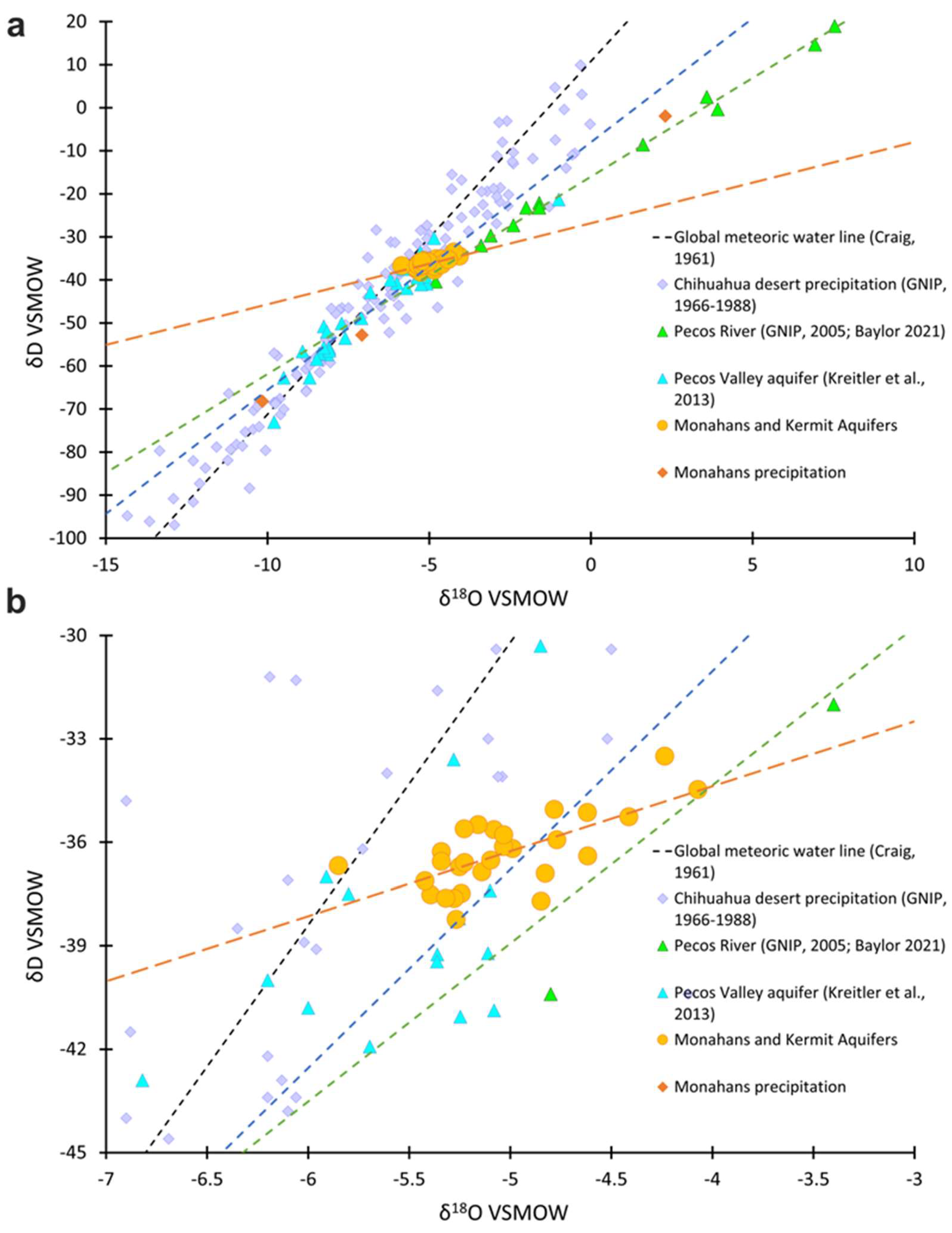
90]. The δD (-33.50 to -38.24 ‰), and δ
18O (-4.07 to -5.85 ‰) ratios for ground water from the Kermit and Monahans dune fields yield similar values with considerably less variability than other isotopic data sets from the Chihuahuan Desert (
Figure 8). These isotopic ratios for groundwater from the Monahans and Kermit dune fields show a surprising similarity potentially reflecting a common water source, consistent aeolian sedimentary architectural context, with the water table perched above the Pleistocene/Pliocene basal red clay aquitard.
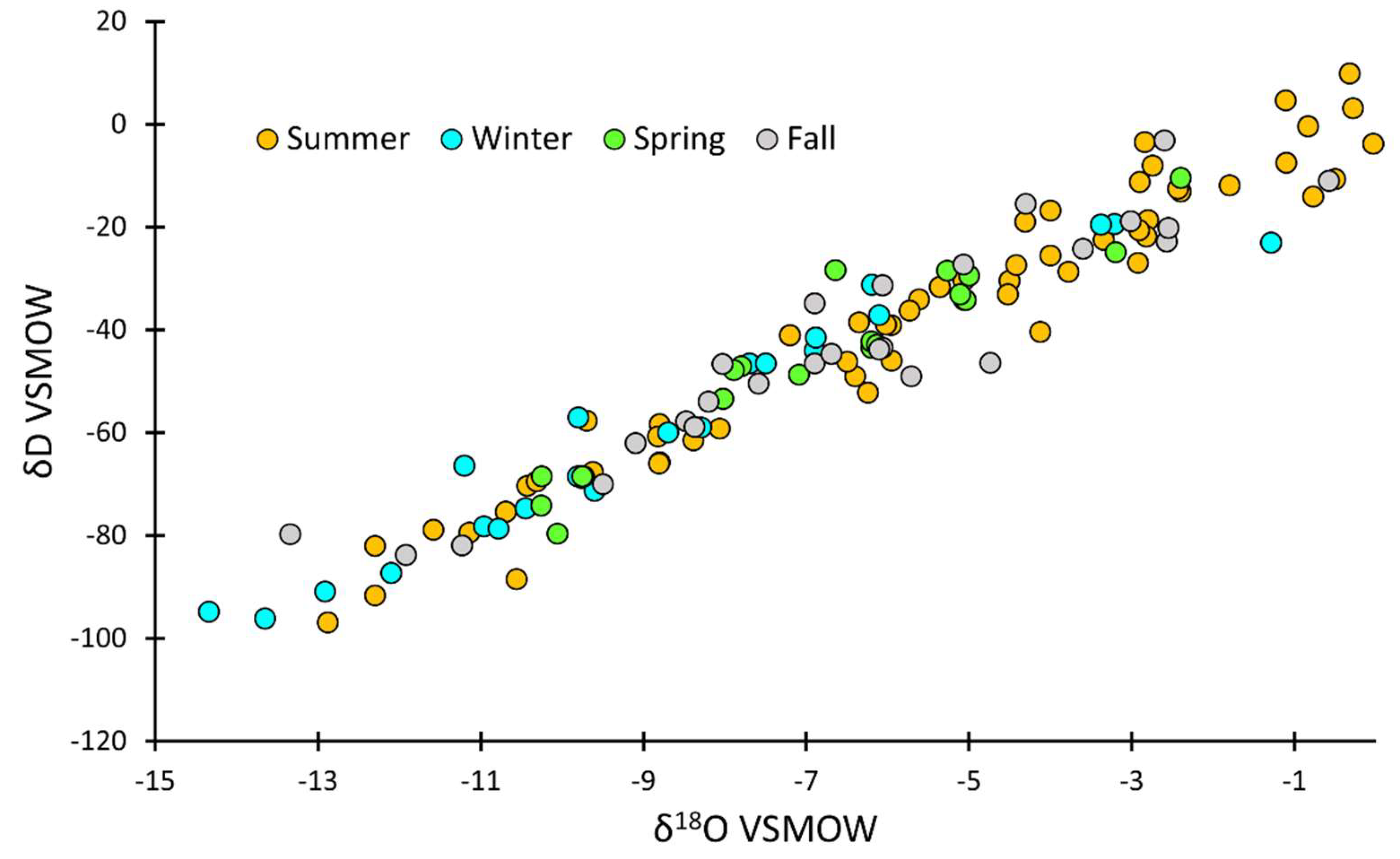
The δD and δ
18O values for Chihuahuan Desert precipitation [
51] display substantial variability with no apparent seasonal trend similar to isotopic values for precipitation events in proximity to the Monahans and Kermit dune fields (
Figure 9,
Table S3). The PVA shows a range of δD and δ
18O values from -73 to -21.30 ‰ and from -9.80 to -1‰ respectively. However, these isotopic values for the PVA are more negative than local precipitation, suggesting limited recharge from modern precipitation [
53]. The δD and δ
18O values for the Pecos River are enriched with distance from the headwaters in the Sangre de Cristo Mountains, NM, reflecting a snowmelt source or, an abundance of elevational recycled moisture [
52]. In contrast, the Pecos River water near Pecos, TX, shows enriched, evaporation-influenced δD and δ
18O values, with up to 33% of stream volume lost through evaporation [
52].
3.4. Radiocarbon Variations of Groundwater
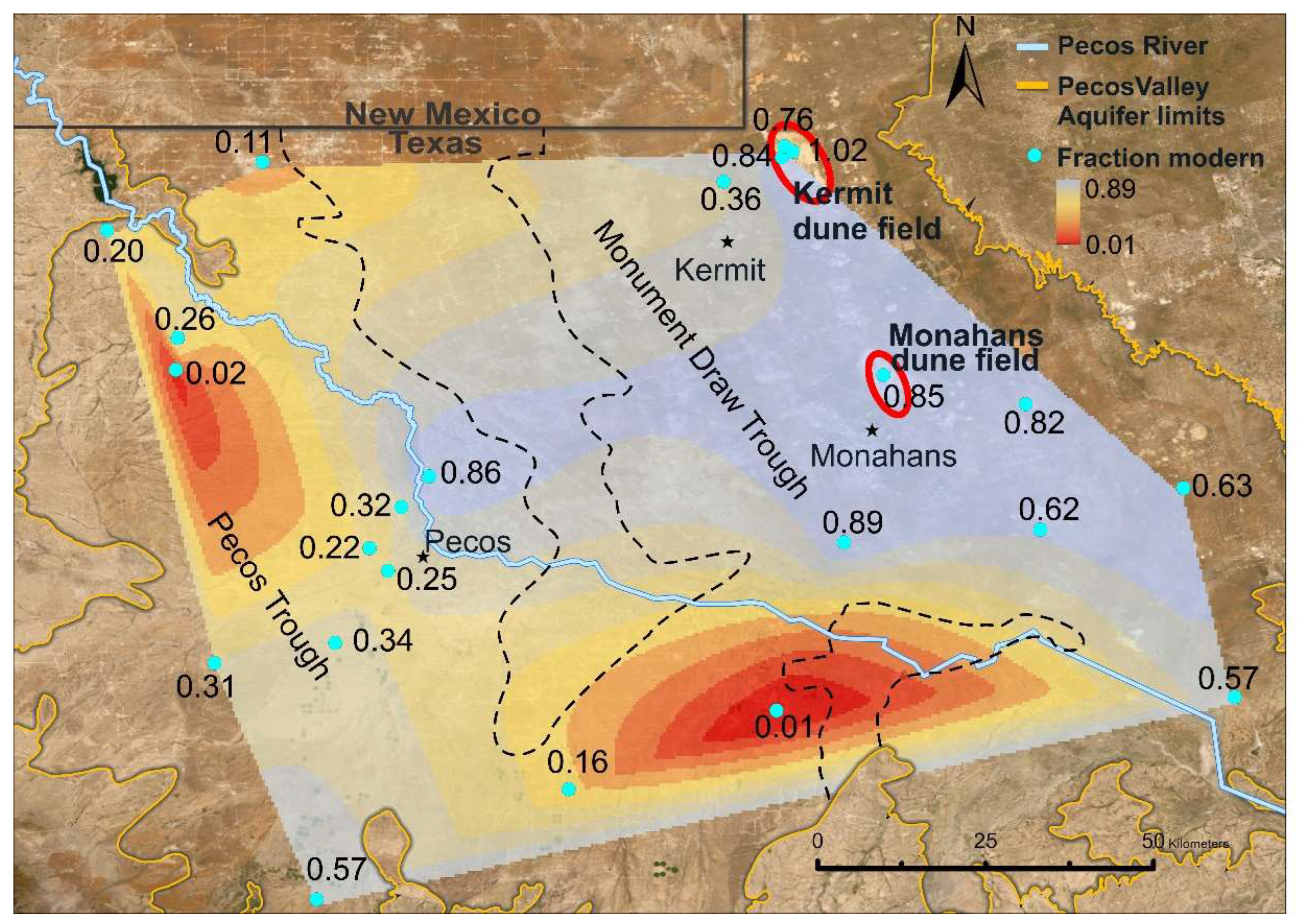
The radiocarbon assays for groundwater are expressed as Fraction modern (Fm) (
Figure 10,
Table 2), a measure of
14C activity in the water sample relative to activity of
14C in 1950 atmospheric CO
2 [
91]. Fm may be related to potential water sources with low Fm < 0.02, close to
14C measurement limit of about 40 to 50 ka reflecting isolation from atmospheric sources, and high Fm >0.95 reflecting ages closer to the radiocarbon datum year of ca. 1950 [
92,
93,
94]. The PVA yields Fm of 0.01 to 0.89, with the lowest values in the Pecos Trough and highest values in the Monument Draw Trough. Furthermore,
14C Fm in the north and east of the Monument Draw Trough appear to gradually increase towards the Pecos River [
53].
The Fm of groundwater from the Monahans and Kermit dune fields indicates recharge from contemporary water sources and the incorporation of older carbon with transit through the dune field aquifer, most likely from dissolution of CaCO
3 dominated paleo-playa lake sediments and buried soils (
Figure 7) [
50]. Groundwater samples from Kermit and Monahans dune fields yielded
14C Fm of 0.76 – 1.0, similar to nearby PVA Fm values (0.89-0.82). The lowest Fm values (0.84-0.76) were from monitoring well 3, near the western descending slope of the Kermit dune field, and a water well pumping ~25 m deep in the center of the dune field. In contrast, the highest Fm value (1.02) for groundwater derived from the topographically higher Kermit dune field interior where the aquifer is shallower (1-2 m deep), reflecting primarily meteoric sources (
Figure 3).
4. Discussion
4.1. Pleistocene – Holocene Dune Field Evolution
This study highlighted the similarities between the Monahans and Kermit dune fields’ internal sedimentary architecture, chronology and water isotopic signature. Both dune fields show a shallow 1 to 10 m deep perched water table above a red gravelly-clay aquitard with sinkhole-like features [
77]. The thickest aeolian sands occur in these sinkhole-like features, which shows no surface expression in the present topography [
50,
77]. The oldest OSL ages on quartz grains of ca. 560 to 540 ka were retrieved from continuous Geoprobe cores on the sand sheet, immediately west of Monahans dune field [
50] and approximately 5 to 10 m above the basal red clay unit [
63]. Previously, the deposition of aeolian sand in the Monahans dune field was inferred to commenced ca. 2.6 ma, based on an inferred correlation to the base of the Blackwater Draw Formation [
50]. However, the onset of aeolian deposition for the Monahans and Kermit aeolian systems may be linked to changes in flow direction of the Pecos River ca. 2.0 to 0.8 ma ago from northwest to south-southwest after headward fluvial erosion of the Stockton Plateau [
66]. Thus, this erosion event may have captured the northerly flowing, a precursor of the modern Pecos River, resulting in a flow direction reversal and eastward avulsion [
66], in proximity to current locations of the Monahans and Kermit dune fields. Geochemical analysis indicates that the dune grains may ultimately be derived from fluvial erosion of upper Triassic Chinle Formation and local aeolian reworking of Pleistocene Blackwater Draw Formation [
50,
60,
95].
OSL dating for aeolian sediment cores from the Kermit dune field recognize two aeolian deposition phases (ADP) that coincide with Monahans ADP at ca. 353-334 ka, and 65-30 ka, possibly corresponding to marine oxygen isotope stages (MOIS) 10 and 3-4 during transitions from glacial to interglacial and stadial periods [
50]. In contrast, there is compelling evidence of higher-than-modern water static levels for the Monahans and Kermit dune fields, with lacustrine sediments yielding OSL ages of ca. 233 ± 14.5 ka and 196 ± 10.9 ka in the Monahans dune field [
50] and ca. 227 ± 12.6 ka in the Kermit dune field. These OSL ages reflect two pluvial episodes corresponding to the onset (240-214 ka) and termination (206-186 ka) of interglacial episode MOIS 7 (186 to 240 ka) [
50,
96]. Climate models for MOIS 7 indicate a positive water budget with enhanced rainfall in southwestern Texas possibly reflecting increased moisture from the Gulf of Mexico with North American Monsoon precipitation rates estimated at ~ 4mm/day [
96,
97]. Pluvial conditions may have prevailed during the warmest intervals of interglacial such as MOIS 5 and possibly 7 [
50,
74,
98]. Wetter conditions also prevailed during the Last Glacial Maximum ca. 25 to 15 ka, with formation of pluvial Lake King in the adjacent Rio Grande catchment [
50,
70].
OSL ages for near surface sediments in the Kermit dune field indicate recent aeolian activity, 1760 CE, just prior to European settlement. This aeolian activity may correspond with periods of drought in the Trans-Pecos region and the Sangre de Cristo Mountains assessed from tree ring records, and decreased flood frequency in the Mississippi River, around 250 ± 30 years ago [
13,
99,
100]. This upper aeolian deposition phase may be coincident with formation of the coppice and parabolic dune fields of the Mescalero sand sheet at ca. 300 years BP in adjacent New Mexico [
69].
4.2. Groundwater Recharge
The Kermit and Monahans dune fields, and possibly other dune systems on the Southern Great Plains, host significant perched aquifers, with volumes > 0.1 km
3. Stable isotopic ratios (D/H and
18O/
16O) on groundwater indicate recharge of the dune field aquifers from contemporary precipitation, particularly when precipitation exceeds evapotranspiration, such as in 2022. Average precipitation and evapotranspiration for the Kermit dune field in 2022, obtained from OpenET [
54], were respectively 307.8 mm and 295.7 mm, thus there may be a small net recharge of 12.1 mm/yr during years with average rainfall. The isotopic signature of water derived from aquifers for Kermit and Monahans dune fields was distinct for water from the PVA and the Pecos River. However, the stable D and
18O isotopic values for dune field groundwater resembles local and Chihuahua Desert precipitation, though more evaporatively enriched (
Figure 8). Precipitation is the only water source to maintain groundwater resources in these dune systems. Water table measurements in the Kermit Dunal Aquifer (KDA) from three monitoring wells and a northeast to southwest transect of auger holes show the top of the water table at 1 to 10 m below the surface [
77]. Net groundwater flow is down elevation towards the southwest and subparallel to the basal red gravely clay paleosurface at 30-40 m depth (
Figure 3).
The
14C fraction modern (Fm) on dissolved inorganic carbon (DIC) may inform on flow path and mixing within an aquifer [
101,
102,
103,
104,
105]. In the KDA, groundwater from a shallow central well (Monitoring well 1) yielded a post-1950 Fm (1.02), which indicated exchange(s) with meteoric sources. Whereas groundwater from the western edge of the dune field (Monitoring well 2) yielded a Fm of 0.84 possibly reflecting additions of older DIC with water flux through the subsurface interacting with buried, older (>100 ka old) playa lake or buried pedogenic carbonate (
Figure 7) [
50] and less pure meteoric source. This variation in stable isotopes of groundwater may indicate recharge most likely occurs from the enhanced capture of precipitation on central bare active dunes of Kermit dune field where infiltration rates are higher, >250 mm/hr, compared to nearly flat vegetated relief of the adjacent sand sheet [
29,
31]. The observed vertical gradient in
14C Fm in the KDA, ranges from 1.02 (post-1950) in shallow >1 m deep groundwater to 0.76 at 30 m deep, may reflect local mine pumping enhancing vertical mixing of groundwater of various recharge times and DIC sources.
Interdunal lake sediments yielded OSL ages of ca. 196 ± 10.9, 227 ±12.6, and 233 ± 14.5 ka which indicated the occurrence of significant pluvial conditions for west Texas dune fields during MOIS 7, with ground water levels at least 1 m higher than current conditions. Periods of higher water table during glacials and peak interglacial periods occurred in past ca. 1 to 2 Ma and added to the stability of the dune field through capillary groundwater rise. These wet periods with pluvial lake formation and concurrent soil formation for 10
3 to 10
4 years aid in vertical accretion and stability of the dune field [
50]. Conversely, diminution in groundwater levels associated with drier conditions and less vegetation cover increases the availability and supply of sand for transport and redeposition across the dune field, with threshold wind speeds > 6 m/s [
62,
106,
107,
108]. The identification of a common aeolian sand unit that yielded OSL ages of ca. 250 year in cores Ker21-2 and Ker21-7 reflects a contemporary period of active aeolian deposition.
4.3. Potential Connection to the Pecos Valley Aquifer
The Monahans and Kermit Dunal Aquifers (MDA, KDA) appear to be semi-independent groundwater systems that may contribute recharge for the Pecos Valley Aquifer. Despite limited reported recharge from precipitation for the PVA [
27], infiltration rates in arid environments are higher on bare sandy soils such as active dunes and playa lakes, that can represent important recharge points to major underlying aquifers like the adjacent Ogallala Aquifer [
29,
109,
110,
111,
112]. Groundwater in the KDA and MDA appears to flow from the NE to SW consistent with the groundwater flow direction in the Monument Draw trough of the PVA [
27,
53]. Also,
14C Fm values (1.02-0.76) from the KDA and MDA are consistent with eastern most
14C Fm values for the PVA (0.89-0.62), indicating a less evolved Fm source water from these dune fields. A water balance calculation with groundwater monitoring data [
77] and evapotranspiration and precipitation data from OpenET [
54] indicates that recharge from the KDA to the PVA could be up to 0.01 km
3 per year or 9% of the 0.112 km
3 estimated total annual recharge in the PVA [
27,
28]. The Monahans dune field may provide similar magnitude recharge.
5. Conclusions
The Kermit and Monahans dune fields rise 10 to 15 m from the surrounding sand sheet environment in far western Texas. The 30 to 40 m thick aeolian strata are at least 550 ka old and are intercalated with up to six paleosols and pluvial lake sediments reflecting hydrologic excess during glacial and peak interglacial conditions, e.g., MOIS 2 and MOIS 7. However, the formation age of these dune systems is unknown with plausible hypotheses as correlative to the Pleistocene (ca. 2.6 ma) Blackwater Draw Formation or with initiation of the southward flow of the Pecos River ca. 2.0 to 0.8 ma [
66,
113]. These dune fields host significant groundwater resources for this semi-arid environment, with volumes > 0.1 km
3, which has not been recognized previously. The water table within the dune fields is usually 1 to 10 m below the surface, with rare interdunal lakes and wetlands and with net groundwater flow down elevation towards the southwest and subparallel to a basal, red, gravely clay, aquitard paleosurface. Sinkhole-like features, 5 to 15 m deep at the top of basal red clay, are infilled with the thickest occurrence of aeolian sand but are not reflected at the surface.
The deuterium (δD) and oxygen (δ
18O) isotopic ratios for groundwater from the Kermit and Monahans dune fields show characteristic isotopic depletion, below the meteoric water line, reflecting the dominance of evaporation, similar to stable isotopes of precipitation from the Chihuahuan Desert [
51,
52,
53,
78,
90]. However, groundwater from dunal sources show considerably less isotopic variability than Chihuahuan Desert rainfall, particularly for deuterium values, which defines a δD to δ
18O function oblique to the meteoric water line (
Figure 8).
The
14C fraction modern (Fm) on dissolved inorganic carbon (DIC) for dune derived groundwater yielded insights on sources of water, flux, and potential mixing. Groundwater from a shallow central well in the Kermit dune field yielded contemporary Fm (1.02), which indicated exchange with recent atmospheric
14C sources. However, groundwater from the elevationally lower western edge of the dune field gave a more evolved Fm of 0.84 possibly reflecting DIC from older (>100 ka) carbonate-bearing playa lake deposits and buried soils within the aeolian stratigraphy of these dune fields [
50]. Groundwater recharge occurs with the enhanced capture of precipitation on mostly bare, high surface area of active dunes of Kermit dune field where infiltration rates are higher, >250 mm/hr, compared to nearly flat vegetated relief of the adjacent sand sheet [
29,
31].
The perched aquifers of the Monahans and Kermit dune fields may contribute up to 9% of the total annual recharge to the regionally Pecos Valley Aquifer (PVA). However, recent mining activities [
20,
57] and increasing aridity since the 1980s [
5,
6] have led to exposure of the water table and enhanced evaporation, creating a moisture deficit that could reduce recharge and deplete the Kermit and Monahans dunal aquifers. This study highlights the importance of dune field systems as potential contributors to regional groundwater resources, particularly in arid and semi-arid regions. Understanding the recharge dynamics, flow patterns, and climatic controls on these perched aquifer systems is crucial for sustainable water resource management in the face of increasing water demands and climate change.
Supplementary Materials
: The following supporting information can be downloaded at:
www.mdpi.com/xxx/s1, Table S1: AT1 – Kermit dune field field borings – Atlas Sand – June-July 2017, February-March 2019 and September 2021; Table S2: AT2 – Monahans dune field borings – Atlas Sand – June 2017 and March 2018; Table S3: δD and δ
18O isotopic ratios for the Kermit and Monahans dune fields collected from three piezometers in Kermit dune field and thirteen production wells from the Kermit and Monahans Atlas mines, as well as for the Pecos Valley Aquifer from the towns of Wink and Monahans TX, for the Pecos River samples collected between Mentone and Grandfalls TX, and for precipitation in Monahans TX; Table S4: Estimation of the recharge contribution from the Monahans and Kermit dune fields to the Pecos Valley Aquifer.
Author Contributions
Conceptualization, A.F. and S.L.F.; formal analysis, A.F., S.L.F and C.M.; funding acquisition S.L.F.; investigation, A.F., S.L.F. and C.M.; methodology, A.F., S.L.F. and C.M; resources, S.L.F. and G.M.; supervision, S.L.F. and G.M.; visualization, S.L.F. and A.F.; writing – original draft, A.F.; writing – review & editing, S.L.F. All authors have read and agreed to the published version of the manuscript.
Funding
This research was partially supported through an award G SS-1660230 from the National Science Foundation.
Data Availability Statement
The original contributions presented in the study are included in the article or supplementary material, further inquiries can be directed to the corresponding authors. Stable Isotopes (D, 18O) datasets for the Chihuahua Desert [
51] and the Pecos River [
52] are publicly available through the International Atomic Energy Agency (IAEA) – Water Isotope System for Data Analysis, Visualization and Electronic Retrieval (WISER) portal as part of the Global Network of Isotopes in Precipitation (GNIP) and Global Network of Isotopes in Rivers (GNIR):
https://nucleus.iaea.org/wiser. Stable Isotopes (D, 18O) and Radiocarbon datasets for the Pecos Valley Aquifer [
53] are available on demand through the contact form of the Texas Water Development Board: twdb.texas.gov.
Acknowledgments
We appreciate the support of Atlas Energy Solutions, Austin, TX, for providing access to the Monahans and Kermit properties, sampling of water wells and logistical assistance. We are grateful to the cities of Wink and Monahans, TX, for allowing access to public water wells screened in the Pecos Valley Aquifer. Many thanks to Jasmine Kidwell, Ashley Gonzalez, Anna Lesko, and Daniel Shi for their assistance in installing piezometers, and retrieving cores and water samples. Assistance in providing OSL ages by Liliana Marin and Gabriela Velasco is much appreciated.
Conflicts of Interest
The authors declare no conflicts of interest. The funders had no role in the design of the study; in the collection, analyses, or interpretation of data; in the writing of the manuscript; or in the decision to publish the results.
References
- White, D.E., 1971. Water Resources of Ward County, Texas, U.S. Geological Survey & Texas Water Development Board, Austin, TX.
- Jones, I.C., 2008. Investigating Recharge in Arid Alluvial Basin Aquifers: The Pecos Valley Aquifer, Texas. Gulf Coast Association of Geological Societies Transactions 58, 489-500.
- Texas A&M AgriLife Extension – Texas ET network. Available online: texaset.tamu.edu– Last accessed on 27th of July 2024.
- National Oceanic and Atmospheric Administration (NOAA) – Climate Data Online. Available online: www.ncei.noaa.gov/cdo-web. Last accessed in June 2024.
- Barandiaran, D., Wang, S.Y., Hilburn, K., 2013. Observed trends in the Great Plains low-level jet and associated precipitation changes in relation to recent droughts. Geophysical Research Letters, 40(23), 6247-6251.
- Arias, P.A., Fu, R., Vera, C., Rojas, M., 2015. A correlated shortening of the North and South American monsoon seasons in the past few decades. Climate Dynamics, 45(11-12), 3183-3203.
- Heo, J., Yu, J., Giardino, R., Cho, H., 2015. Water Resources Response to Climate and Land-Cover Changes in a Semi-Arid Watershed, New Mexico, USA. Terrestrial Atmospheric and Oceanic Sciences, 26.
- Haskell, D., Heo, J., Park, J., Dong, C., 2022. Hydrogeochemical Evaluation of Groundwater Quality Parameters for Ogallala Aquifer in the Southern High Plains Region, USA. International Journal of Environmental Research and Public Health, 19(14), 8453.
- Scanlon, B.R., Reedy, R.C., Wolaver, B.D., 2022. Assessing cumulative water impacts from shale oil and gas production: Permian Basin case study. Science of The Total Environment, 811, 152306.
- Bertrand, D., Mcpherson, R.A., 2018. Future Hydrologic Extremes of the Red River Basin. Journal of Applied Meteorology and Climatology, 57(6), 1321-1336.
- Zipper, S.C., Hammond, J.C., Shanafield, M., Zimmer, M., Datry, T., Jones, C.N., Kaiser, K.E., Godsey, S.E., Burrows, R.M., Blaszczak, J.R., Busch, M.H., Price, A.N., Boersma, K.S., Ward, A.S., Costigan, K., Allen, G.H., Krabbenhoft, C.A., Dodds, W.K., Mims, M.C., Olden, J.D., Kampf, S.K., Burgin, A.J., Allen, D.C., 2021. Pervasive changes in stream intermittency across the United States. Environmental Research Letters, 16(8), 084033.
- Huggins, X., Gleeson, T., Kummu, M., Zipper, S.C., Wada, Y., Troy, T.J., Famiglietti, J.S., 2022. Hotspots for social and ecological impacts from freshwater stress and storage loss. Nature Communications, 13(1).
- Forman, S.L., Wu, Z., Wiest, L., Marin, L., Mayhack, C., 2023. Late Quaternary fluvial and aeolian depositional environments for the western Red River, Southern Great Plains, USA. Quaternary Research, 115, 3-24.
- Langman, J., Ellis, A., 2010. Geologic influences on source-water mixing along a paleochannel in the Southern High Plains aquifer, New Mexico. Carbonates and Evaporites, 25, 247-265.
- Howell, N., 2021. Comparative Water Qualities and Blending in the Ogallala and Dockum Aquifers in Texas. Hydrology, 8(4), 166.
- Hassani, K., Taghvaeian, S., Gholizadeh, H., 2021. A Geographical Survey of Center Pivot Irrigation Systems in the Central and Southern High Plains Aquifer Region of the United States. Applied Engineering in Agriculture, 37(6), 1139-1145.
- Pathak, S., Adusumilli, N.C., Wang, H., Almas, L.K., 2022. Irrigation water demand and elasticities: a case study of the High Plains aquifer. Irrigation Science, 40(6), 941-954.
- Lauer, S., Sanderson, M.R., Manning, D., Suter, J.F., Hrozencik, R., Guerrero, B., Golden, B., 2018. Values and groundwater management in the Ogallala Aquifer region. Journal of Soil and Water Conservation, 73, 593-600.
- Overacker, J., Hammond, W.C., Blewitt, G., Kreemer, C., 2022. Vertical Land Motion of the High Plains Aquifer Region of the United States: Effect of Aquifer Confinement Style, Climate Variability, and Anthropogenic Activity. Water Resources Research, 58(6).
- Mace, R., Jones, C., 2023. Frac Sand Facilities and Their Potential Effects on the Groundwater Resources of the Monahans-Mescalero Sand Ecosystem, Permian Basin, Texas. Texas Water Journal, 14(1), 62-80.
- Venkataraman, K., Tummuri, S., Medina, A., Perry, J., 2016. 21st century drought outlook for major climate divisions of Texas based on CMIP5 multimodel ensemble: Implications for water resource management. Journal of Hydrology, 534, 300-316.
- Nielsen-Gammon, J.W., Banner, J.L., Cook, B.I., Tremaine, D.M., Wong, C.I., Mace, R.E., Gao, H., Yang, Z.L., Gonzalez, M.F., Hoffpauir, R., Gooch, T., Kloesel, K., 2020. Unprecedented Drought Challenges for Texas Water Resources in a Changing Climate: What Do Researchers and Stakeholders Need to Know? Earth’s Future, 8(8).
- Hauer, M.E., 2019. Population projections for U.S. counties by age, sex, and race controlled to shared socioeconomic pathway. Scientific Data, 6(1), 190005.
- Hudak, P., 2005. Radioactivity in the Ogallala and Dockum Aquifers, northwest Texas, USA. Environmental Geology, 47, 283-289.
- Chaudhuri, S., Ale, S., 2014. Temporal evolution of depth-stratified groundwater salinity in municipal wells in the major aquifers in Texas, USA. Science of The Total Environment, 472, 370-380.
- Lozano, J., Heo, J., Seo, M., 2021. Historical Assessments of Inorganic Pollutants in the Sinkhole Region of Winkler County, Texas, USA. Sustainability, 13(13), 7513.
- Anaya, R., Jones, I., 2009. Groundwater Availability Model for the Edwards-Trinity (Plateau) and Pecos Valley Aquifers of Texas, Texas Water Development Board, Austin, TX.
- Bruun, B., Jackson, K., Lake, P., Walker, j., 2016. Texas Aquifers Study - Groundwater Quantity, Quality, Flow, and Contributions to Surface Water, Texas Water Development Board, Austin, TX.
- Berger, D.L., 1992. Groundwater recharge through active sand dunes in northwestern Nevada. Water Resources Bulletin, 28(5), 959-965.
- Chen, J.S., Li, L., Wang, J.Y., Barry, D.A., Sheng, X.F., Gu, W.Z., Zhao, X., Chen, L., 2004. Water resources - Groundwater maintains dune landscape. Nature, 432(7016), 459-460.
- Keese, K.E., Scanlon, B.R., Reedy, R.C., 2005. Assessing controls on diffuse groundwater recharge using unsaturated flow modeling. Water Resources Research, 41(6).
- Scanlon, B.R., Reedy, R.C., Male, F., Walsh, M., 2017. Water Issues Related to Transitioning from Conventional to Unconventional Oil Production in the Permian Basin. Environmental Science & Technology, 51(18), 10903-10912.
- Bai, Y., Wang, N.A., Liao, K.T., Klenk, P., 2011. Geomorphological evolution revealed by aeolian sedimentary structure in Badain Jaran Desert on Alxa Plateau, Northwest China. Chinese Geographical Science, 21(3), 267-278.
- Ma, N., Wang, N.A., Zhao, L.Q., Zhang, Z.Y., Dong, C.Y., Shen, S.P., 2014. Observation of mega-dune evaporation after various rain events in the hinterland of Badain Jaran Desert, China. Chinese Science Bulletin, 59(2), 162-170.
- Wang, X., Zhao, H., Sheng, Y., Geng, J., Wang, K., Yang, H., 2020. Groundwater net discharge rates estimated from lake level change in Badain Jaran Desert, Northwest China. Science China Earth Sciences, 63(5), 713-725.
- Wang, W., Jiaqi, c., Jiansheng, C., Lucheng, Z., Tao, W., Yitong, Z., Dewen, H., 2024. Basalt and Dunes: Critical factors in Desert Water Resource Development. ACS ES&T Water, online.
- Liang, S.M., Yan, H.L., Zhang, X.M., Xie, T.T., Zhu, J.T., Zhang, Z.W., 2008. Physiological response of natural C. taklimakanensis B.R.Pan et G.M.Shen to unconfined groundwater in the hinterland of the Taklimakan Desert. Chinese Science Bulletin, 53, 112-118.
- Huang, T.M., Pang, Z.H., Chen, Y.N., Kong, Y.L., 2013. Groundwater circulation relative to water quality and vegetation in an arid transitional zone linking oasis, desert and river. Chinese Science Bulletin, 58(25), 3088-3097.
- Hammond, D.J., 1998. Measuring Changes In Areal Extent Of Historic Wetlands At Great Sand Dunes National Monument, Colorado 1936-1995. M.S., Colorado State University, Fort Collins, CO, 81p.
- Wurster, F.C., Cooper, D.J., Sanford, W.E., 2003. Stream/aquifer interactions at Great Sand Dunes National Monument, Colorado: influences on interdunal wetland disappearance. Journal of Hydrology, 271(1-4), 77-100.
- Marin, L., Forman, S.L., Valdez, A., Bunch, F., 2005. Twentieth century dune migration at the Great Sand Dunes National Park and Preserve, Colorado, relation to drought variability. Geomorphology, 70(1-2), 163-183.
- Chen, X., Chen, X.H., Rowe, C., Hu, Q., Anderson, M., 2003. Geological and climatic controls on streamflows in the Nebraska Sand Hills. Journal of the American Water Resources Association, 39(1), 217-228.
- Chen, X.H., Chen, X., 2004. Simulating the effects of reduced precipitation on ground water and streamflow in the Nebraska Sand Hills. Journal of the American Water Resources Association, 40(2), 419-430.
- Befus, K.M., Cardenas, M.B., Ong, J.B., Zlotnik, V.A., 2012. Classification and delineation of groundwater-lake interactions in the Nebraska Sand Hills (USA) using electrical resistivity patterns. Hydrogeology Journal, 20(8), 1483-1495.
- Bolles, K., Forman, S.L., Sweeney, M., 2017. Eolian processes and heterogeneous dust emissivity during the 1930s Dust Bowl Drought and implications for projected 21st-century megadroughts. Holocene, 27(10), 1578-1588.
- Bolles, K.C., Forman, S.L., 2018. Evaluating Landscape Degradation Along Climatic Gradients During the 1930s Dust Bowl Drought From Panchromatic Historical Aerial Photographs, United States Great Plains. Frontiers in Earth Science, 6.
- Vengosh, A., Hening, S., Ganor, J., Mayer, B., Weihenmayer, C.E., Bullen, T.D., Paytan, A., 2007. New isotopic evidence for the origin of groundwater from the Nubian Sandstone Aquifer in the Negev, Israel. Applied Geochemistry, 22(5), 1052-1073.
- El-Meselhy, A., Abdelhalim, A., Nabawy, B.S., 2020. Geospatial analysis in groundwater resources management as a tool for reclamation areas of New Valley (El-Oweinat), Egypt. Journal of African Earth Sciences, 162.
- Chen, J.S., Zhao, X., Sheng, X.F., Dong, H.Z., Rao, W.B., Su, Z.G., 2006. Formation mechanisms of megadunes and lakes in the Badain Jaran Desert, Inner Mongolia. Chinese Science Bulletin, 51(24), 3026-3034.
- Forman, S.L., Tew-Todd, V., Mayhack, C., Marín, L., Wiest, L.A., Money, G., 2022. Late Quaternary aeolian environments, luminescence chronology and climate change for the Monahans dune field, Winkler County, West Texas, USA. Aeolian Research, 58, 100828.
- Oestlund, 1962-Chihuahua Precipitation, International Atomic Energy Agency - Water Isotope System for Electronic Retrieval.
- Yuan, F., Miyamoto, S., 2008. Characteristics of oxygen-18 and deuterium composition in waters from the Pecos River in American Southwest. Chemical Geology, 255(1-2), 220-230.
- Kreitler, C.W., Bassett, R., Beach, J.A., Symank, L., Uliana, M., Ewing, J., Kelley, V., 2013. Evaluation of Hydrochemical and Isotopic Data in Groundwater Management Areas 3 and 7, Texas Water Development Board.
- Open ET. Available online: etdata.org. Last accessed in June 2024.
- Cooper Waitt, M.E., 1969. Desert dunes of the Kermit sandhills, Winkler County, Texas, M.A., University of Texas, Austin, TX, 78p.
- Machenberg, M.D., 1984. Geology of Monahans Sandhills State Park, Texas, Bureau of Economic Geology, Austin, TX.
- Mace, R.E., 2019. Frac Sand Facilities and Their Potential Effects on the Groundwater Resources of the Monahans-Mescalero Sand Ecosystem, Permian Basin, Texas. Texas State University, San Marcos, TX.
- Meyer, J.E., Wise, M.R., Kalaswad, S., 2012. Pecos Valley Aquifer, West Texas: Structure and Brackish Groundwater, Texas Water Development Board, Austin, TX.
- Holliday, V.T., 2001. Stratigraphy and geochronology of upper quaternary eolian sand on the Southern High Plains of Texas and New Mexico, United States. Geological Society of America Bulletin, 113(1), 88-108.
- Rich, J., Stokes, S., 2011. A 200,000-year record of late Quaternary Aeolian sedimentation on the Southern High Plains and nearby Pecos River Valley, USA. Aeolian Research, 2(4), 221-240.
- Stout, J.E., 2015. Diurnal patterns of blowing dust on the Llano Estacado. Journal of Arid Environments, 122, 85-92.
- Sweeney, M.R., Lacey, T., Forman, S.L., 2023. The role of abrasion and resident fines in dust production from aeolian sands as measured by the Portable in-situ Wind Erosion Laboratory (PI-SWERL). Aeolian Research, 63-65, 100889.
- Mayhack, C., 2021. Late Quaternary Sedimentary Architecture and Depositional History of the Monahans Dune Field, Winkler County, TX. M.S., Baylor University, Waco, TX, 26p.
- Forman, S., Wiest, L., Mayhack, C., Tew-Todd, V., Liang, P., Wu, Z., Money, G., 2019. Fourth Dimensional Understanding of Late Pleistocene Eolian Depositional Environments for The Monahans Dune Field, Texas USA - Farouk El-Baz Award For Desert Research, GSA 2019. Abstracts with Programs. Geological Society of America, Phoenix, AZ.
- Holliday, V.T., 1989. The Blackwater Draw Formation (Quaternary): A 1.4-plus-m.y. record of eolian sedimentation and soil formation on the Southern High Plains. Geological Society of America Bulletin, 101, 1598-1607.
- Cather, S.M., Heizler, M.T., 2023. A north-flowing precursor to the Pecos River in the Gatuña Formation of southeastern New Mexico and Texas. In: N.M.G. Society (Ed.), 73 rd Annual Fall Field Conference. New Mexico Bureau of Geology & Mineral Resources, pp. 89-101.
- Mayhack, C., Forman, S., Wiest, L., Tew-Todd, V., Marin, L., Money, G., 2019. Late quaternary eolian stratigraphy and changing environments of the Monahans dune field, TX, GSA 2019. Abstracts with Programs. Geological Society of America, Phoenix, AZ.
- Spears, B., 2022. Seismic Site Characterization via Joint Inversion of Horizontal-to-Vertical Spectral Ratios and Surface Wave Dispersion: Developing and Validating a Geophysical Tool for Paleoclimate Studies. M.S., Baylor University, Waco, TX, 30p.
- Hall, S.A., Goble, R.J., 2023. Quaternary and Archaeological Geology of the Mescalero Plain, Southeastern New Mexico. New Mexico Bureau of Geology and Mineral Resources Bulletin 165, 216p.
- Wilkins, D.E., Currey, D.R., 1997. Timing and extent of late Quaternary paleolakes in the Trans-Pecos Closed Basin, west Texas and south-central New Mexico. Quaternary Research, 47(3), 306-315.
- Hall, S.A., Goble, R.J., 2015. OSL age and stratigraphy of the Strauss sand sheet in New Mexico, USA. Geomorphology, 241, 42-54p.
- Hall, S.A., Miller, M.R., Goble, R.J., 2010. Geochronology of the Bolson sand sheet, New Mexico and Texas, and its archaeological significance. Geological Society of America Bulletin, 122(11-12), 1950-1967.
- Wiest, L.A., Lukens, W.E., Driese, S.G., Peppe, D.J., Forman, S.L., 2020. Landscape evolution across the Cretaceous/Paleogene boundary in southwestern North Dakota, U.S.A. Cretaceous Research, 112, 104470.
- Insel, N., Berkelhammer, M., 2021. The influence of orbital parameters on the North American Monsoon system during the Last Interglacial Period. Journal of Quaternary Science, 36(4), 638-648.
- Musgrove, M., Banner, J., Le Combs, D.M., James, E., Cheng, H., Edwards, R, 2001. Geochronology of late Pleistocene to Holocene speleothems from Central Texas: Implications for regional paleoclimate. Geological Society of America Bulletin, 113, 1532-1543.
- Cisneros-Dozal, L.M., Huang, Y., Heikoop, J.M., Fawcett, P.J., Fessenden, J., Anderson, R.S., Meyers, P.A., Larson, T., Perkins, G., Toney, J., Werne, J.P., Goff, F., Wolde, G., Allen, C.D., Berke, M.A., 2014. Assessing the strength of the monsoon during the late Pleistocene in southwestern United States. Quaternary Science Reviews, 103, 81-90.
- Fournier, A., Forman, S., Yelderman, J., Money, G., Kidwell, J., Gonzalez, A., 2022. Potential Processes for Annual and Daily Fluctuations of Perched Aquifer in the Monahans and Kermit Dune Fields, West Texas, USA, GSA Connect 2022. Abstracts with Programs. Geological Society of America, Denver, CO.
- Craig, H., 1961. Isotopic Variations in Meteoric Waters. Science, 133(3465), 1702-1703.
- Uliana, M.M., Banner, J.L., Sharp, J.M., 2007. Regional groundwater flow paths in Trans-Pecos, Texas inferred from oxygen, hydrogen, and strontium isotopes. Journal of Hydrology, 334(3), 334-346.
- Phan, V.A., Zeigler, K.E., Vinson, D.S., 2021. High Plains groundwater isotopic composition in northeastern New Mexico (USA): relationship to recharge and hydrogeologic setting. Hydrogeology Journal, 29(4), 1445-1461.
- Gillon, M., Barbecot, F.,Gibert, E., Corcho Alvarado, J.A.,Marlin, C., Massault, M., 2009. Open to closed system transition traced through the TDIC isotopic signature at the aquifer recharge stage, implications for groundwater 14C dating. Geochimica et Cosmochimica Acta, 21 (73), 6488-6501,.
- Paine, J.G., 1994. Subsidence beneath a playa basin on the Southern High Plains, U.S.A.: Evidence from shallow seismic data. Geological Society of America Bulletin, 106, 233-242.
- Johnson, K.S., 2005. Subsidence hazards due to evaporite dissolution in the United States. Environmental Geology, 48(3), 395-409.
- Kim, J.-W., Lu, Z., Kaufmann, J., 2019. Evolution of sinkholes over Wink, Texas, observed by high-resolution optical and SAR imagery. Remote Sensing of Environment, 222, 119-132.
- Galbraith, R.F., Roberts, R.G., 2012. Statistical aspects of equivalent dose and error calculation and display in OSL dating: An overview and some recommendations. Quaternary Geochronology, 11, 1-27.
- Murray, A.S., Wintle, A.G., 2003. The single aliquot regenerative protocol: potential for improvements in reliability. Radiation Measurements, 37, 377381.
- Wintle, A.G., Murray, A.S., 2006. A review of quartz optically stimulated luminescence characteristics and their relevance in single aliquot regeneration protocols. Radiation Measurements, 41, 369-391.
- Liang, P., Forman, S.L., 2019. LDAC: an Excel based program for luminescence equivalent dose and burial age calculations. Ancient TL, 37 (2), 21-39.
- Prescott, J. R. and Hutton, J. T., 1994. Cosmic ray contributions to dose rates for luminescence and ESR dating: Large depths and long-term time variations. Radiation Measurements, 23, 497–500.
- Bouchaou, L., Hsissou, Y., Krimissa, M., Krimissa, S., Mudry, J.N., 2005. 2H and 18O isotopic study of groundwaters under a semi-arid climate. Environmental Chemistry: Green Chemistry and Pollutants in Ecosystems, 57-64.
- Hua, Q., Turnbull, J.C., Santos, G.M., Rakowski, A.Z., Ancapichún, S., De Pol-Holz, R., Hammer, S., Lehman, S.J., Levin, I., Miller, J.B., Palmer, J.G., Turney, C.S.M., 2022. Atmospheric Radiocarbon for The Period 1950–2019 Radiocarbon, 64(4), 723-745.
- Stuiver, M., Polach, H.A., 1977. Discussion: Reporting of 14C data. Radiocarbon, 19(3), 355-363.
- Stuiver, M., 1980. Workshop on 14C data reporting. Radiocarbon, 22(3), 964-969.
- Plummer, L., Glynn, P. Chapter 4: Radiocarbon dating in groundwater systems. In Isotope Methods for Dating Old Groundwater, Non-serial Publications, International Atomic Energy Agency, Vienna, Austria, 2013, pp 33-90.
- Muhs, D.R., Holliday, V.T., 2001. Origin of late quaternary dune fields on the Southern High Plains of Texas and New Mexico. Geological Society of America Bulletin, 113(1), 75-87.
- Choudhury, D., Timmermann, A., Schloesser, F., Heinemann, M., Pollard, D., 2020. Simulating Marine Isotope Stage 7 with a coupled climate–ice sheet model. Climate of the Past, 16(6), 2183-2201.
- Kutzbach, J.E., Liu, X., Liu, Z., Chen, G., 2008. Simulation of the evolutionary response of global summer monsoons to orbital forcing over the past 280,000 years. Climate Dynamics, 30(6), 567-579.
- Colleoni, F., Masina, S., Cherchi, A., Iovino, D., 2014. Impact of Orbital Parameters and Greenhouse Gas on the Climate of MIS 7 and MIS 5 Glacial Inceptions. Journal of Climate, 27(23), 8918-8933.
- Cleaveland, M.K., Votteler, T.H., Stahle, D.K., Casteel, R.C., Banner, J.L., 2011. Extended Chronology of Drought in South Central, Southeastern, and West Texas. Texas Water Journal, 2(1), 54-96.
- Munoz, S.E., Gruley, K.E., Massie, A., Fike, D.A., Schroeder, S., Williams, J.W., 2015. Cahokia’s emergence and decline coincided with shifts of flood frequency on the Mississippi River. Proceedings of the National Academy of Sciences, 112(20), 6319-6324.
- Purdy, C.B., Burr, G.S., Rubin, M., Helz, G.R., Mignerey, A.C., 1992. Dissolved organic and inorganic 14C concentrations and ages for Coastal Plain Aquifer in Southern Maryland. Radiocarbon, 34(3), 654-663.
- McMahon, P., Bohlke, J., Carney, C., 2007. Vertical gradients in water chemistry and age in the northern High Plains aquifer, Nebraska, 2003.
- Meredith, K.T., Han, L.F., Cendon, D.I., Crawford, J., Hankin, S., Peterson, M., Hollins, S.E., 2018. Evolution of dissolved inorganic carbon in groundwater recharged by cyclones and groundwater age estimations using the 14C statistical approach. Geochimica et Cosmochimica Acta, 220, 483-498.
- Fang, S.C., 2019. Study on 14C dating analysis of deep groundwater resources on islands. Journal of Environmental Radioactivity, 208-209, 105994.
- Thomas, J.M., Hershey, R.L., Fereday, W., Burr, G., 2021. Using Carbon-14 of dissolved organic carbon to determine groundwater ages and travel times in aquifers with low organic carbon. Applied Geochemistry, 124, 104842.
- Wang, F., Donghuai, S., Chen, F., Bloemendal, J., Guo, F., Li, Z., Zhang, Y., Baofeng, L., Wang, X, 2015. Formation and evolution of the Badain Jaran Desert, North China, as revealed by a drill core from the desert center and by geological survey. Palaeogeography, Palaeoclimatology, Palaeocology, 426, 139-158.
- Bradley, R.W., Venditti, J.G., 2019. The growth of dunes in rivers. Journal of Geophysical Research: Earth Surface. 124, 548-566.
- Gao, J., Kennedy, D.M., Konlechner, T.M., McSweeney, S., Chiaradia, A. & McGuirk, M., 2022. Changes in the vegetation cover of transgressive dune fields: A case study in Cape Woolamai, Victoria. Earth Surface Processes and Landforms, 47(3), 778–792.
- Dincer, T., Al-Mugrin, A., Zimmermann, U., 1974. Study of the infiltration and recharge through the sand dunes in arid zones with special reference to the stable isotopes and thermonuclear tritium. Journal of Hydrology, 23, 79-109.
- Wang, X.-P., Cui, Y., Pan, Y.-X., Li, X.-R., Yu, Z., Young, M.H., 2008. Effects of rainfall characteristics on infiltration and redistribution patterns in revegetation-stabilized desert ecosystems. Journal of Hydrology, 358(1), 134-143.
- Gurdak, J.J., Roe, C.D., 2010. Review: Recharge rates and chemistry beneath playas of the High Plains aquifer, USA. Hydrogeology Journal, 18(8), 1747-1772.
- Starr, S.M., McIntyre, N.E., 2020. Land-cover changes and influences on playa wetland inundation on the Southern High Plains. Journal of Arid Environments, 175, 104096.
- Hall, S., Goble, R., 2020. Middle Pleistocene IRSL age of the upper Blackwater Draw Formation, Southern High Plains, Texas and New Mexico, USA. New Mexico Geology, 42(1), 31-38p.
|
Disclaimer/Publisher’s Note: The statements, opinions and data contained in all publications are solely those of the individual author(s) and contributor(s) and not of MDPI and/or the editor(s). MDPI and/or the editor(s) disclaim responsibility for any injury to people or property resulting from any ideas, methods, instructions or products referred to in the content. |
© 2024 by the authors. Licensee MDPI, Basel, Switzerland. This article is an open access article distributed under the terms and conditions of the Creative Commons Attribution (CC BY) license (http://creativecommons.org/licenses/by/4.0/).
