Preprint
Article

Dismissed Industrial Areas, the Urban Project of the Montedison Factoryof Akgragas in Porto Empedocle between the Past, Present and Future

Altmetrics

Downloads

86

Views

24

Comments

0

A peer-reviewed article of this preprint also exists.

This version is not peer-reviewed

Submitted:

23 August 2024

Posted:

23 August 2024

You are already at the latest version

Alerts
Abstract
In recent decades, both in Italy and internationally, the phenomenon of abandoned industrial buildings has grown considerably, causing inevitable social, urban and economic impacts. At the same time, the cultural debate has increased awareness of the problem and the strategic role that abandoned industrial sites can play in responding to new needs. This contribution analyzes the dismantling process of the Akragas Montedison factory in Porto Empedocle, Sicily, examining the evolution of disused industrial areas from the 20th century to the present day and the possibilities of reconversion for appropriate reuse.
Keywords: 
Subject: Environmental and Earth Sciences  -   Environmental Science

1. Introduction

Climate change, with rising global temperatures and the reduction of ice mass in Europe and globally, leads to longer summers, scarcity of rainfall, and extreme events, prompting us to reflect on future choices and what we must accomplish now. Reducing land consumption, rethinking the architecture and urban planning of spaces, considering water as a precious resource, and transforming abandoned industrial buildings into places for study, leisure, etc., are some possible responses. All cities, large and small, from north to south, must face these issues. Improving these areas is crucial for sustainable urban development, representing inevitable economic and social opportunities. This article presents the preliminary results of the research “Disused Industrial Areas, the Urban Project of the Akragas Montedison Plant in Porto Empedocle, between Past, Present, and Future,” which explores this case study, from the birth of the plant to its evolution and abandonment, proposing solutions for its future conversion and use. It is in these spaces, once occupied by factories, roads, and warehouses, that the contemporary city must be born, in a context of environmental compatibility and reintegration of new functions and users in the disused areas [1].
Research indicates that redevelopment objectives must be defined within the decision-making process, which, in accordance with the principles of the Audis Charter [1], must be initiated and guided by the administration with the participation of territorial actors, both economic and collective. Governance actions should therefore aim to steer the various phases of the project cycle: from the knowledge phase to focusing on collective interest, from identifying the strategic role to developing project ideas, from evaluation to achieving agreement among the various actors. The cycle should conclude with the identification of a project solution: one capable of meeting the needs expressed by the various stakeholders and, above all, capable of delivering significant urban, environmental, economic, social, and landscape benefits in terms of sustainability and total quality (Russo, 1998).
The term “industrial decommissioning” refers to the process of partial or total demolition of areas and individual buildings used for industrial activities (Densero, 1993). The causes can include the end of the life cycle of the structures, environmental pollution, and location, which may no longer be favorable due to labor costs and sources of energy and raw materials. The phenomenon of dismantling industrial buildings became evident from the second half of the 20th century, coinciding with the crisis in some manufacturing areas and the transition from a Fordist [2] industrial society to a post-industrial society characterized by services. Unused industrial buildings today are a significant part of the building fabric, especially in countries with a long industrial history, varying greatly in formal, typological, structural, and technological characteristics. Many of these buildings, if not properly maintained, are in advanced states of decay.
The need for sustainable urban regeneration raises the issue of recovering disused industrial buildings, which, as in the case of the former Montedison plant in Porto Empedocle, can play an important role in urban transformation, offering different hypotheses for their future use. The goal is to enhance the industrial complex through a methodology that includes a literature review, collection of archival and project material, photographs, and direct analysis with field visits, studying the historical significance and future opportunities.
The dismantling of buildings or areas has a genesis linked to the past, as it follows the change in human needs over the course of history. Gianluca Giovanelli (1997) described the topic as part of a natural process related to the development of habits and urban center design. In the case of industrial buildings, decommissioning occurs when the original productive function is interrupted for various reasons, rendering the building unusable. The main causes of the phenomenon, which can be grouped into economic, technological, environmental, and urban planning factors, include: product crisis, decline of traditional productive sectors, local and global competition, and energy resource crises. Technological factors concern the deterioration of buildings and the obsolescence of production systems. Environmental factors include the impact of productive activities and the depletion of local raw materials. Urban factors include urban transformations and inadequate infrastructure.
From a historical perspective, the phenomenon emerged globally in the 1970s, initially affecting old industrialization areas in Europe and the United States, and later the regions of Southern Europe and the Mediterranean, including Italy (Densero, 1993). The first disused industrial buildings belonged to the steel, metallurgical, shipbuilding, textile, and mining sectors. Two fundamental phases can be identified: the 1970s (Arca Petrucci & Densero, 1995), characterized by the energy crisis and decentralization of production, and the 1980s, characterized by productive reorganization and the internationalization of the economy, with a progressive shift of investments from the manufacturing to the service sector (Piemontese, 2007). These changes led to the abandonment of numerous industrial buildings worldwide that, due to obsolete production processes and/or their location, could not keep up with progress, creating urban voids that represent opportunities for urban regeneration.
The industrial fabric is transformed and moves from a traditional “central space” model/schema (Farinelli, 2003) to a disordered and polycentric scheme in the urban fabric (Sposito, 2012), a complex network structure (Russo, 1998) where there are many former industrial areas within the territory. Modern urban planning must address the transformation of the existing, the “building within the built” (Gregotti, 1984), seeking new design methods that consider relationships with the context and the specificity of places (Secchi, 1984).
The available literature sources on the dimensions of the phenomenon in Europe are often imprecise or outdated. From the report of the European CLARINET [4]. working group, based on a 2002 study, in Germany, disused industrial areas occupy about 146,000 hectares, in Great Britain 76,607, in France 26,400, in the Netherlands 11,000, in Belgium 14,500, and in Switzerland 1,700 hectares. In Italy [5], in the province of Milan alone, disused areas occupied about 1,260 hectares during the same period.

2. Materials and Methods

The case study, former Montedison area of Porto Empedocle
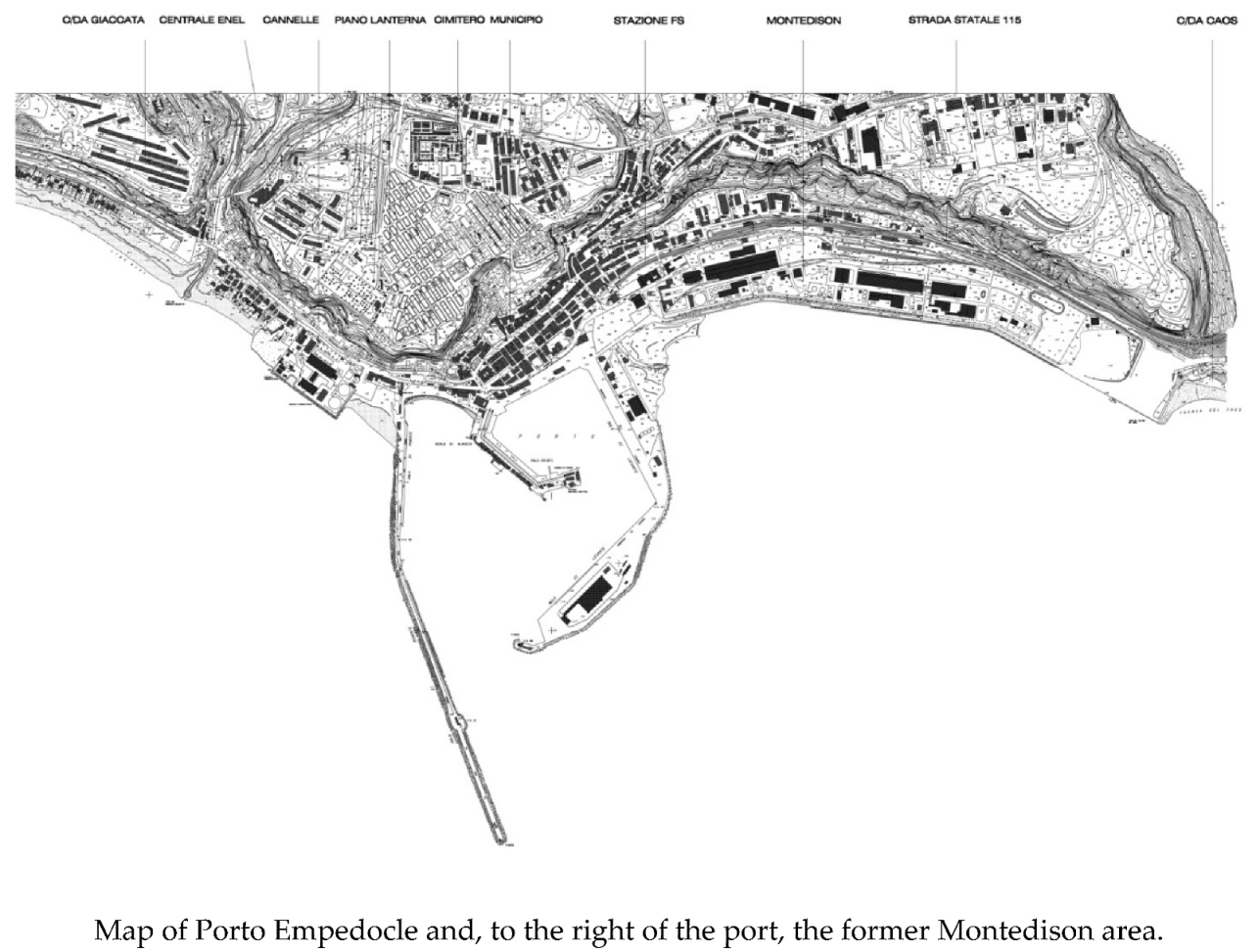
Preprints 116110 i001
The Akragas S.p.A. [6] plant is located to the east of the city of Porto Empedocle, in an area mostly reclaimed from the sea with landfill material. The actual construction work began in 1953/55, after a thorough demining and reclamation of the entire stretch of beach involved in the development was carried out in 1952, so that the foundations of all the buildings rested on driven piles. The choice of the site for the Akragas branch in Porto Empedocle, in the Montecatini area [7], was of exceptional importance because it allowed the new site to produce fertilizers using raw materials from the Sicilian subsoil (sulfur - potassium sulfate - rock salt) or otherwise produced in Sicily (Montecatini ammonia - Augusta petrochemicals) and others (phosphorites) from nearby deposits in the Mediterranean basin (Morocco, Jordan, Israel, and Tunisia).
Additionally, Porto Empedocle had a port planned for continuous development and a SGES (Società Generale Elettrica Siciliana) power plant. The only issue was the water supply, which faced serious shortages until 1962, when Montedison, with significant economic efforts, installed its own aqueduct in the Margimuto area, in the municipality of Santa Stefano di Quisquina (Ag), 80 km from Porto Empedocle.
The plant was commissioned in 1955 and ceased production in 1984.

2.2. The Relationship of the Plant with the Sea and the City

Porto Empedocle is located two meters above sea level, on the slope that descends towards the coast between Punta Piccola and San Leone, in the province of Agrigento. The city has a population of 17,587 inhabitants. Porto Empedocle is a commercial city with a well-equipped port. It is also a fishing center, serving as a base for the collection and sale of deep-sea fish. It is rapidly developing as a tourist destination. There are chemical, mechanical, and cement industries.
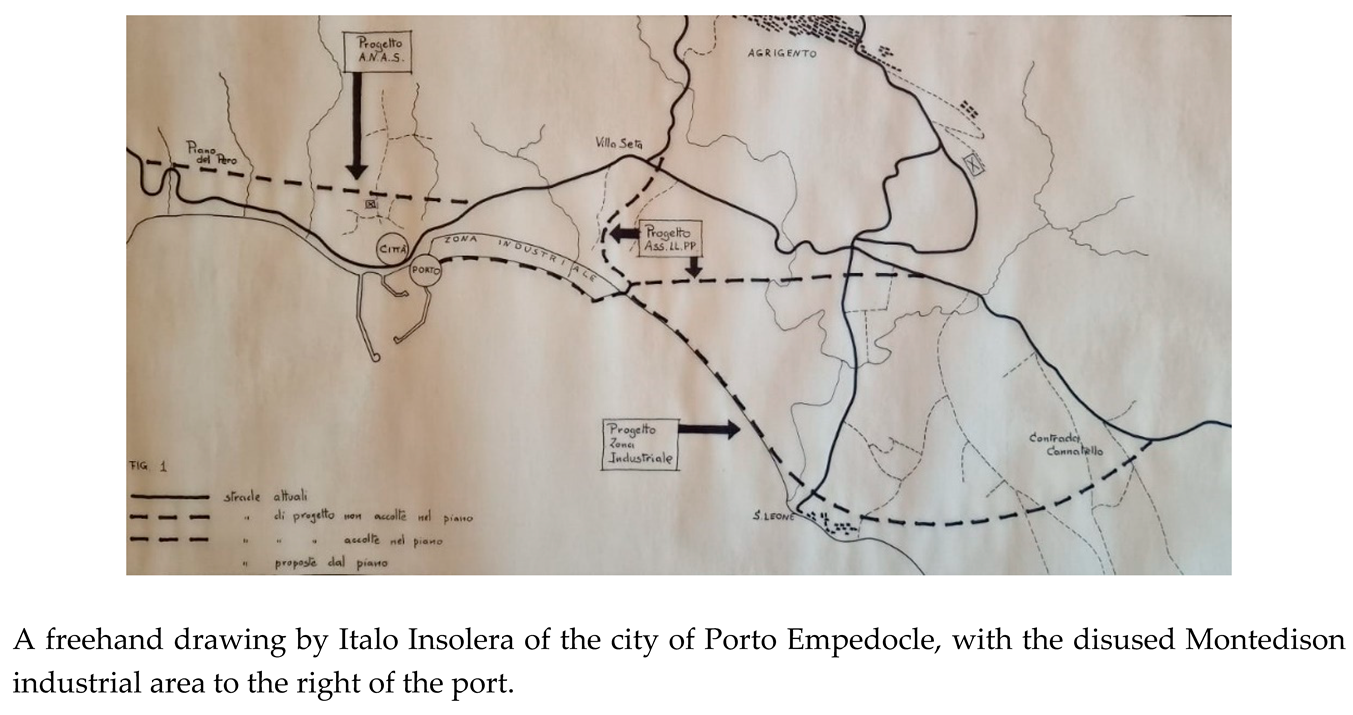
Preprints 116110 i002
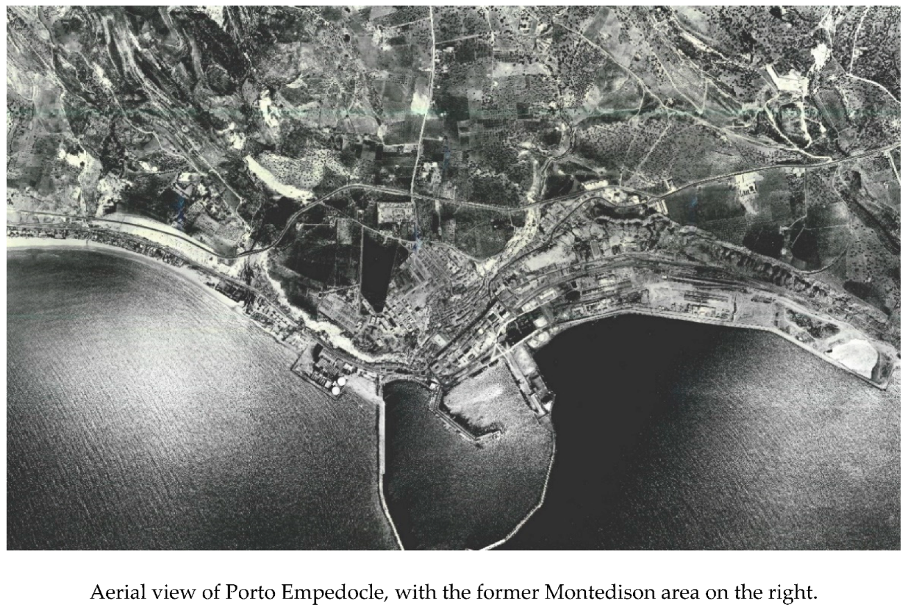
The industrial complex built in the mid-1950s by the Akragas company with the Montedison group covers an area of approximately 115,000 square meters. The area is almost rectangular in shape, with an east-west horizontal span of about 1.4 km and a north-south span of about 240 meters. Following the work by the ASI consortium, the space between the breakwater and State Road 640 was filled in.
The end result of this new space is an area abandoned to decay and neglect, which has completely distorted the relationship between the industrial plant and the city with the waterfront. In fact, the shape of the infill has altered the harmony of the waterfront and the port area. Due to its location relative to the urban center of Porto Empedocle and its characteristics, the factory constitutes a separate city that does not have a direct relationship with the urban center.

2.3. Italo Insolera and the Reconstruction Plan of Porto Empedocle

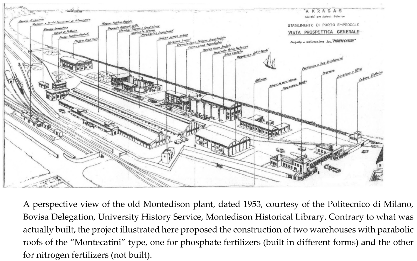
Preprints 116110 i003
In 1956, the young architect Italo Insolera [8] (27 years old) was commissioned by the Municipal Administration of Porto Empedocle to draft the Reconstruction Plan. To fulfill his task, he conducted preliminary studies, created drawings, and carried out a photographic campaign. The photographs depict the industrial activity of Akragas of Montecatini, which was expected to ensure wealth, prosperity, and employment for the local population for decades.
Porto Empedocle can be considered a sort of archetype of a 1950s Italy experiencing the post-war period with the most optimistic prospects for economic growth and industrial development of its territory. However, as history has often shown in the following years, these expectations were not always met.

The Reconstruction Plans

The urgency to rebuild and provide shelter for thousands of displaced families led to the issuance of urgent regulatory measures, shortly after the last military operations on Italian territory had ended. The main measure was the Legislative Decree Lieutenant No. 154/1945, which introduced the obligation to adopt a specific reconstruction plan for the municipalities included in the lists approved by the Ministry of Public Works. The aim was to expedite the reconstruction of the country and areas damaged by the war with utmost urgency and to simplify building interventions.
The philosophy behind this regulation was not at all aimed at carrying out a philological reconstruction, a sort of urban restoration “as it was, where it was,” but rather looked towards future planning. While the decree intended not to compromise the rational future development of the inhabitants, there was also a certain awareness that the reconstruction of damaged areas provided an opportunity to redevelop many realities. In the vast majority of cases, the inhabited areas affected by the war had a well-established historical nature, and complete reconstruction would have restored urban situations worthy of reconsideration.
Porto Empedocle was included on May 14, 1955, in the 44th list of Italian municipalities required to draft a Reconstruction Plan pursuant to Legislative Decree Lieutenant No. 154/1945 and Law No. 1402/1951. The task was assigned to architect Italo Insolera by the Civil Engineering Department of Agrigento on April 28 [9], 1956. The plan was approved in 1957.

2.4. The Technical Description of the Buildings and General Works

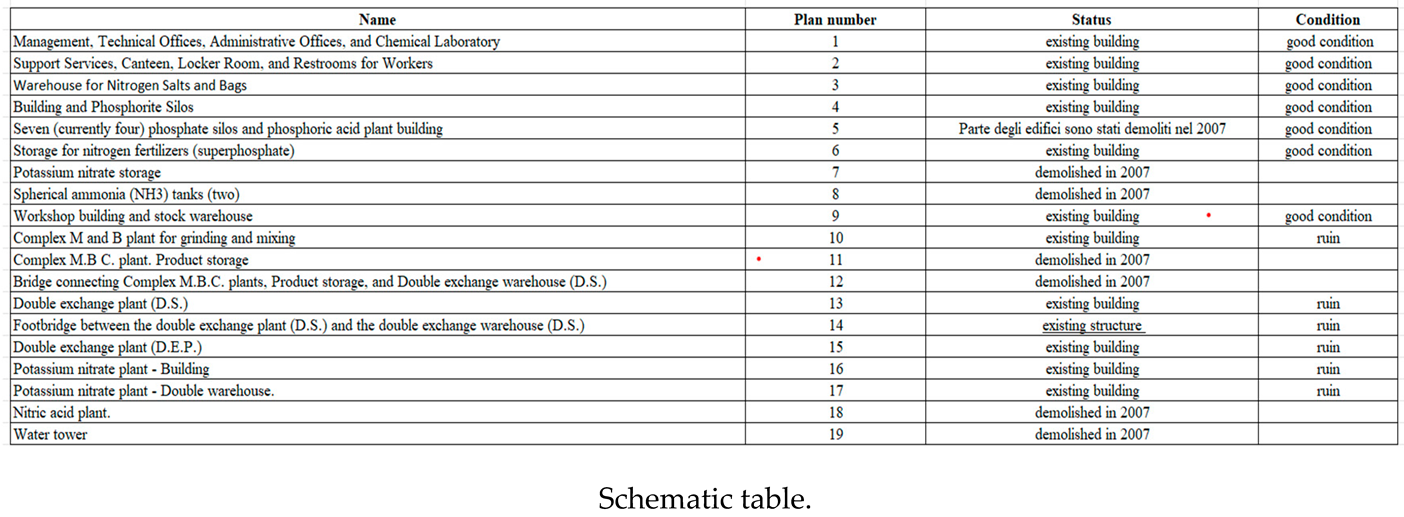
Preprints 116110 i004
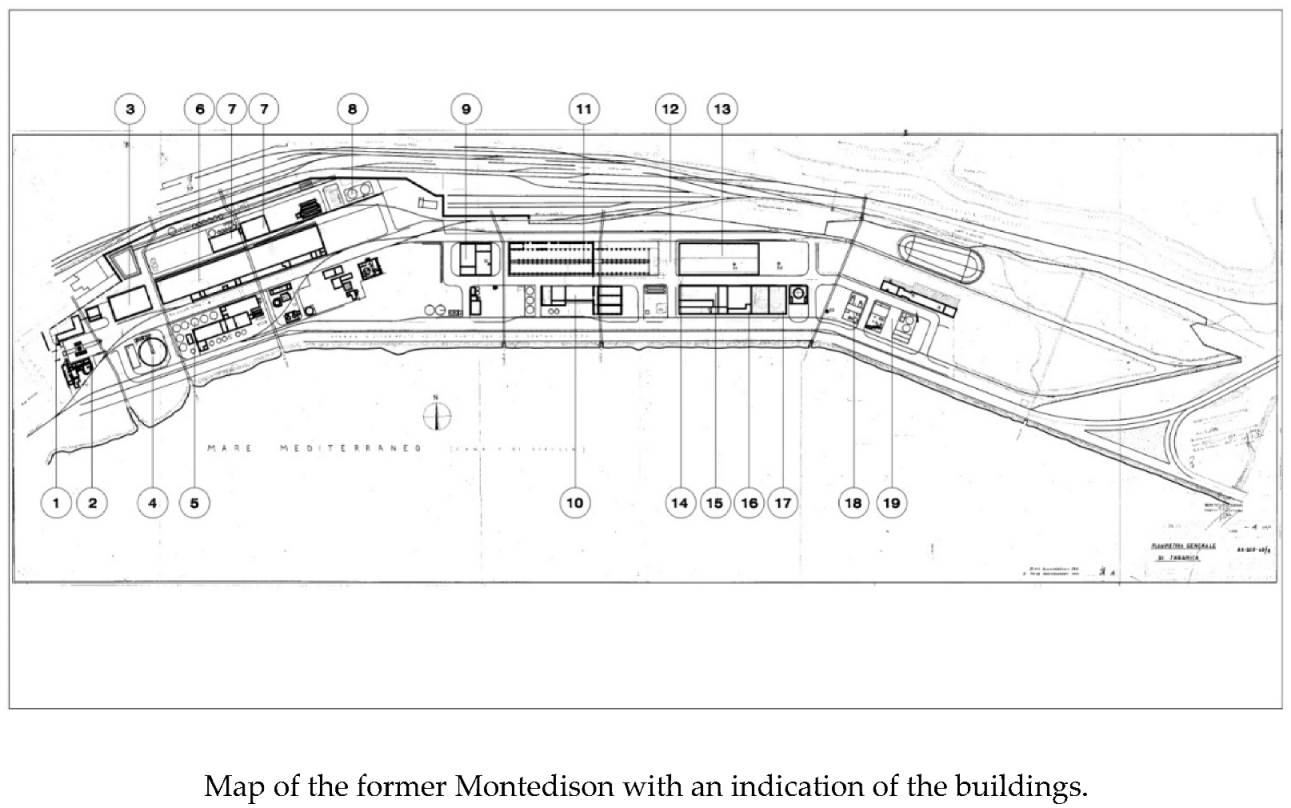
The description of the buildings and structures within the plant is based on the site plan of the plant and follows a narrative from west (where the entrance to the plant is located) to east, providing (where possible) the year of construction, whether the structure is still present (or has been demolished), and a brief technical description. The documentation was obtained from the Technical Office of the Municipality of Porto Empedocle. The former Montedison area has undergone demolitions by the company Syndial, commissioned by the Maritime Property Authority.
Preprints 116110 i005
Map of the former Montedison area. Plates AK-SG 0, AK-SG 0-40/3, and PE 16184/6. The description of the buildings that follows was made possible thanks to the site plans of the former Montedison plant. It is also noted that some of the buildings described below were unfortunately demolished between 2007 and 2010. This has worsened the possibility of recovering the area, which today appears altered from an architectural and urban planning perspective compared to the original layout and the logic of the operations and production processes that were carried out.
In plate SG 0-40/3, north of the nitric plant and the water tower, beyond the internal tracks serving the plant, a water collection basin is shown, which was never built.
Preprints 116110 i006
1. Management, Technical Offices, Administrative Offices, and Chemical Laboratory. Plate 3A-380/2. Existing building. On the west side, adjacent to the square facing the current Via Giuliano Guazzelli, there are two buildings connected by a portico with two entrances, allowing vehicles to enter and exit the plant.
The building located at the bottom (to the south) on the general plan, with a covered area of 240 square meters, housed the plant management, offices, and a small chemical laboratory. It has an almost rectangular shape (18 x 30 meters) and rises over two floors with a pavilion roof. The structure is made of reinforced concrete and dates back to the 1960s. The building is accessible, in good condition, and currently in use by the Carabinieri Station Command.
1. Gatehouse, Welfare Services, Cafeteria, Changing Rooms, and Sanitary Facilities for Workers. Practices 1928 of 28.07.1974 and 35/74 of 29.07.1974. Existing building. Connected by a driveway portico, it continues upward (to the north) from the general plan of the previous building. This is a civil building with an area of 650 square meters, designed to house the gatehouse, welfare services, cafeteria, changing rooms, and sanitary facilities for the workers. It has an L shape, with the base facing north, measuring 23.50 meters in length, 35.70 meters in height, and 9.30 meters in depth. It rises over two floors with a pavilion roof. The structure is made of reinforced concrete and was built in the 1960s. The building is accessible and in good condition.
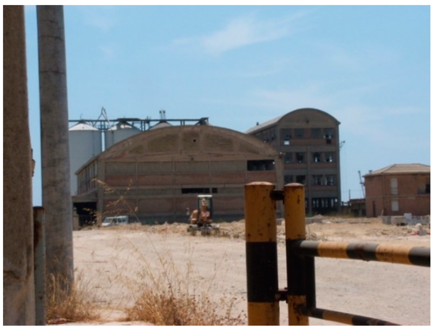
2. Building and Silos for Phosphorite. Project plans not found. Existing building. Continuing east along the central driveway, there is a rectangular building measuring 10 x 30 meters, with its longer side oriented north-south, rising over two floors with a pavilion roof. The ground floor has large openings for vehicle entry, and the first floor has large windows. This is a building used for material storage. The building is in good condition.
Adjacent to it on the east side is the phosphorite silo, a circular reinforced concrete structure with an internal diameter of 36 meters. The foundations consist of a circular perimeter ring resting on drilled piles with a diameter of 600 mm and a maximum length of 12 meters.
The perimeter wall was built with a constant thickness of 40 cm and a height of 13.90 meters above ground level. The upper closure was made with a truncated conical slab varying in thickness from 40 cm to 20 cm. Inside the silos, beneath the floor, there is a diametral tunnel with a net section of 2.10 x 2.10 meters, with foundations resting on drilled piles with a diameter of 600 mm and a length of 12 meters. The building is in good condition.
3. Building - Warehouse for Nitrogen Salts and Bags. Project plans not found. Existing building. In front of the silo, toward the top (north side) of the general plan, across the driveway, there is a rectangular building measuring 30.60 x 50.00 meters (with the longer side parallel to the road). The building, intended as a warehouse for storing nitrogen salts (30,000 quintals) and bags (10,000 units), is located east of the gatehouse and service building. It rises over two floors and has a flat, non-walkable roof, currently used for solar panels. The structure is made of reinforced concrete and was built in the 1970s. The building is accessible and in good condition.
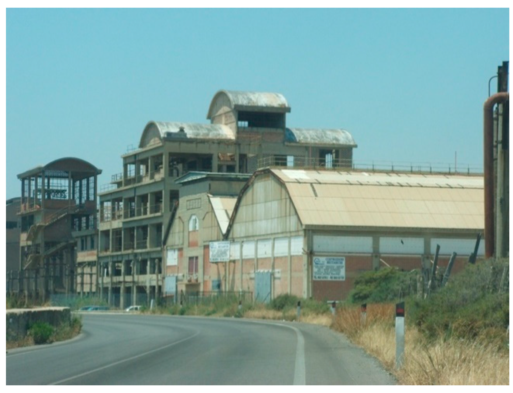
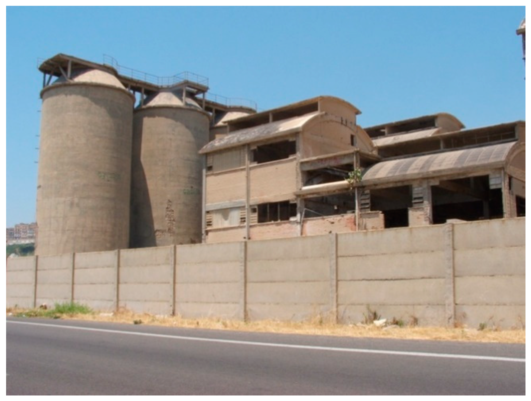
4. Seven (Currently Four) Phosphate Silos and Phosphoric Acid Plant Building. Project plans not found. Part of the buildings were demolished in 2007. Next to the large silo mentioned in point 2, on the right (east side), there were seven silos intended to contain phosphate. Three of these silos were positioned perpendicular to the internal driveway, and the other four were parallel to the road, forming an L shape. The silos, with a diameter of 10 meters and a height of approximately 21 meters, have a reinforced concrete structure and can each hold 2,000 tons of phosphate. All the silos were connected at the top by a reinforced concrete walkway with a parapet. Subsequently, the three silos perpendicular to the road were demolished, and currently, four remain parallel to the road. The remaining silos are accessible and in mediocre condition.
Within the L shape of the silos, there were two rectangular buildings, placed adjacent but offset from each other. One, with a rectangular shape of 75.00 x 16.50 meters, was intended for the phosphoric acid plant and extended over three floors with a barrel-vaulted roof. The second, placed adjacent and offset relative to the first, had a rectangular shape of 50.00 x 16.50 meters and was intended for subsequent processing. Both were demolished in 2007.
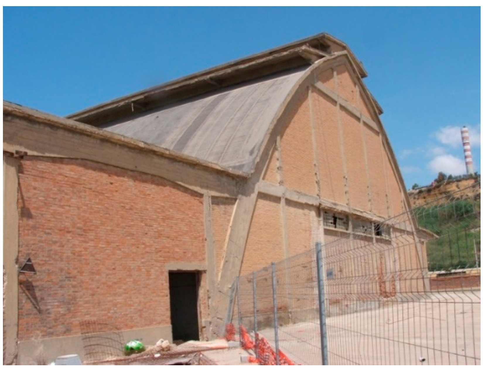
5. Nitrogen Fertilizer Warehouse (Superphosphate). Project plans not found. The building was demolished in 2007. Crossing the driveway to the north, with the silos behind, there is the large nitrogen fertilizer warehouse used for storage. Built in 1953, the building is a large common paraboloid with a reinforced key, measuring 145 meters in length and 32.50 meters in width, reached at the top by an aerial walkway connecting to the production plants. In the following three years, the company began producing phosphazote, a binary fertilizer with a high phosphoric acid content. Consequently, to increase the storage capacity of the plant, the parabolic silo was expanded with the addition of a second section, 70 meters long, identical to the first, also connected to the phosphazote plant. Fully completed in 1956, the paraboloid reached a record length of 215 meters and a maximum ridge height of 17 meters. Particularly interesting is the introduction of automated bagging and distribution stations, consisting of multi-story towers with a base of 7.50 x 6.50 meters, positioned along one of the longer sides of the warehouse.
The design of the superphosphate warehouse in Porto Empedocle, as well as the entire plant, was directly managed by the Technical Directorate of Montecatini and carried out by Borio Mangiarotti of Milan, with contributions from engineer Giuseppe Borio for the construction of reinforced concrete and features very similar to those of Montecatini in Vercelli. Following renovation work, the bagging stations and some of the side canopies were removed, partially altering the building. The building is accessible, currently used as a kennel, and is in a mediocre state of conservation. Solar panels have been placed on the roof.
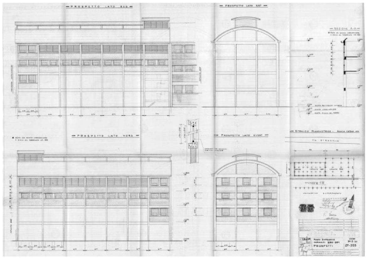
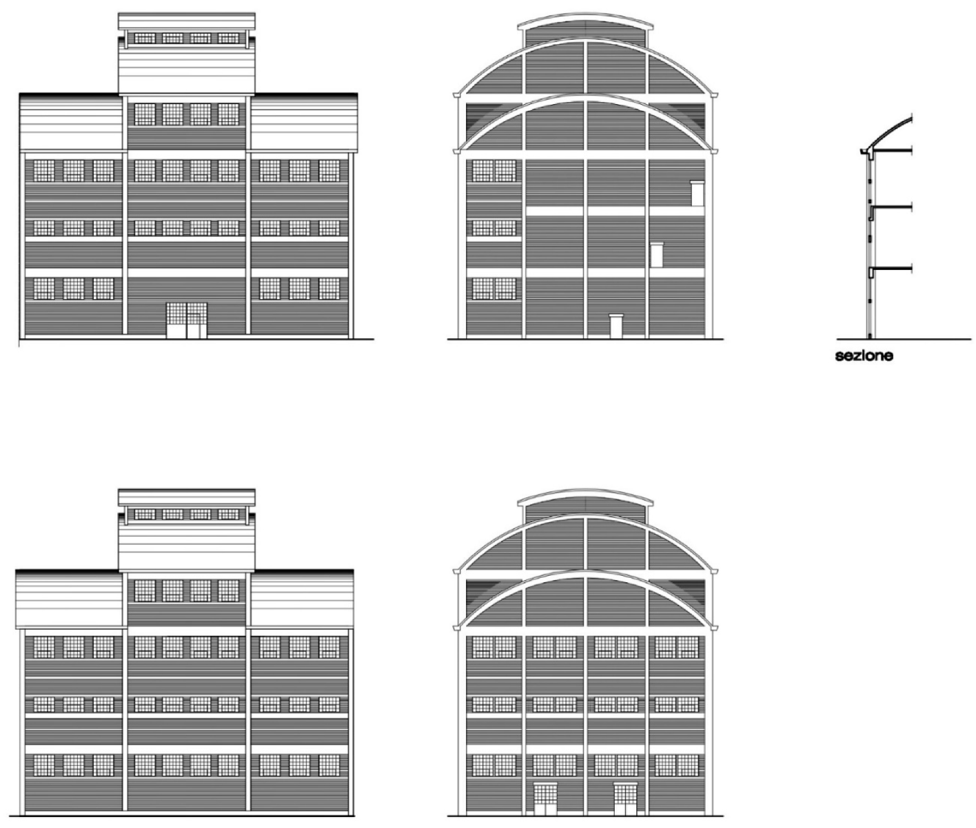
6. Potassium Nitrate Warehouses. Plates 2F-353, 2F-354/3, 2B-544, and 2B-542/4. The buildings were demolished in 2007. Above the nitrogen fertilizer warehouse, also known as the superphosphate warehouse (to the north), there was a structure intended for the storage of potassium nitrate, consisting of two buildings that were structurally independent and separated by 10 cm. The buildings, placed parallel to the superphosphate warehouse, were called Plant 390 (to the west) and Plant 335 (to the east). Plant 390 had a rectangular plan measuring 43 x 18 meters with a reinforced concrete frame structure spanning seven bays, rising over four floors above ground with a gutter height of 18.50 meters, and a barrel-vaulted roof with an overhead skylight. Almost adjoining (at a distance of 10 cm), to the east was Plant 335, a rectangular building measuring 32 x 24 meters, with a reinforced concrete frame structure spanning three bays, rising over three floors above ground with a gutter height of 24 meters, and a barrel-vaulted roof with an overhead skylight. The buildings were demolished in 2007.
7. Spherical Tanks (two) for NH3, Ammonia. Plate AK 182-15. The buildings were demolished in 2007. Continuing east, in line with the warehouses for potassium nitrate production and near the perimeter wall of the plant, we find the spherical tanks that contained ammonia. There were two tanks, each with a diameter of 16 meters and a height of about 20 meters. The structure was made of reinforced concrete and was built in the mid-1960s. The tanks were demolished in 2007.
8. Workshop and Stock Warehouse Building. Project plans not found. The building is existing.. Continuing east, there was the building designated as a workshop and stock warehouse. This building is located in the area secured in 2007 by the reclamation company Syndial S.p.A., near the border with the area assigned to the Moncada Energy Group and aligned with the slab of the former superphosphate warehouse. The construction was carried out in the second half of the 1960s, placing two sheds measuring 20 x 40 meters next to each other. The frame structure is made of reinforced concrete, set on a square plan measuring 40 x 40 meters between the axes of the end columns. It has a gutter height of 6.40 meters and a vault roof in lightweight SAP with iron chains.
The supporting structures consist of isolated footings resting on precast prestressed concrete piles, 7 meters long, driven in with an appropriate pile driver, reinforced concrete columns all with a center distance of 5 meters, connecting beams for footings, roof beams, and overhead crane beams in the carpentry and repair rooms. The perimeter infill walls are made with brick masonry, plastered to a smooth finish inside and with exposed brick on the outside. The building is currently inaccessible but appears to be in good condition from the outside.
9. Complex Plant - M and B Title, Milling, and Mixing. Plates 2B-548, 2B-555, 2B-546, 2B-550, 2B-551. The building is existing. Below (to the south) of the majestic complex plant - product warehouse, there is a complex of three buildings, which from west to east are named: Complex Plant - M and B Title Milling and Mixing, Complex Plant - M and B Title, and Complex Plant - M and B Title Intermediate Warehouse.
The first is a rectangular building measuring 24 x 12 meters (with the longer side parallel to the coastline), on two/three levels, with a reinforced concrete structure and a barrel-vaulted roof with an overhead skylight. The second is a rectangular building measuring 36 x 18 meters (with the longer side parallel to the coastline), on four levels, with a reinforced concrete structure and a barrel-vaulted roof with an overhead skylight. The third building has characteristics similar to the second.
The following buildings, 10, 11, 12, 13, and 14, are connected by walkways for material handling.
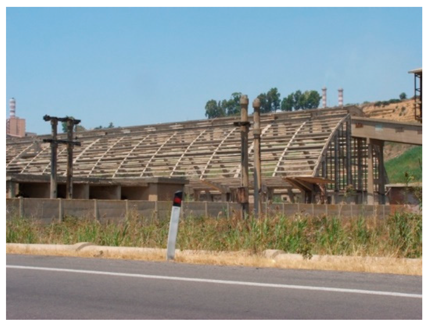
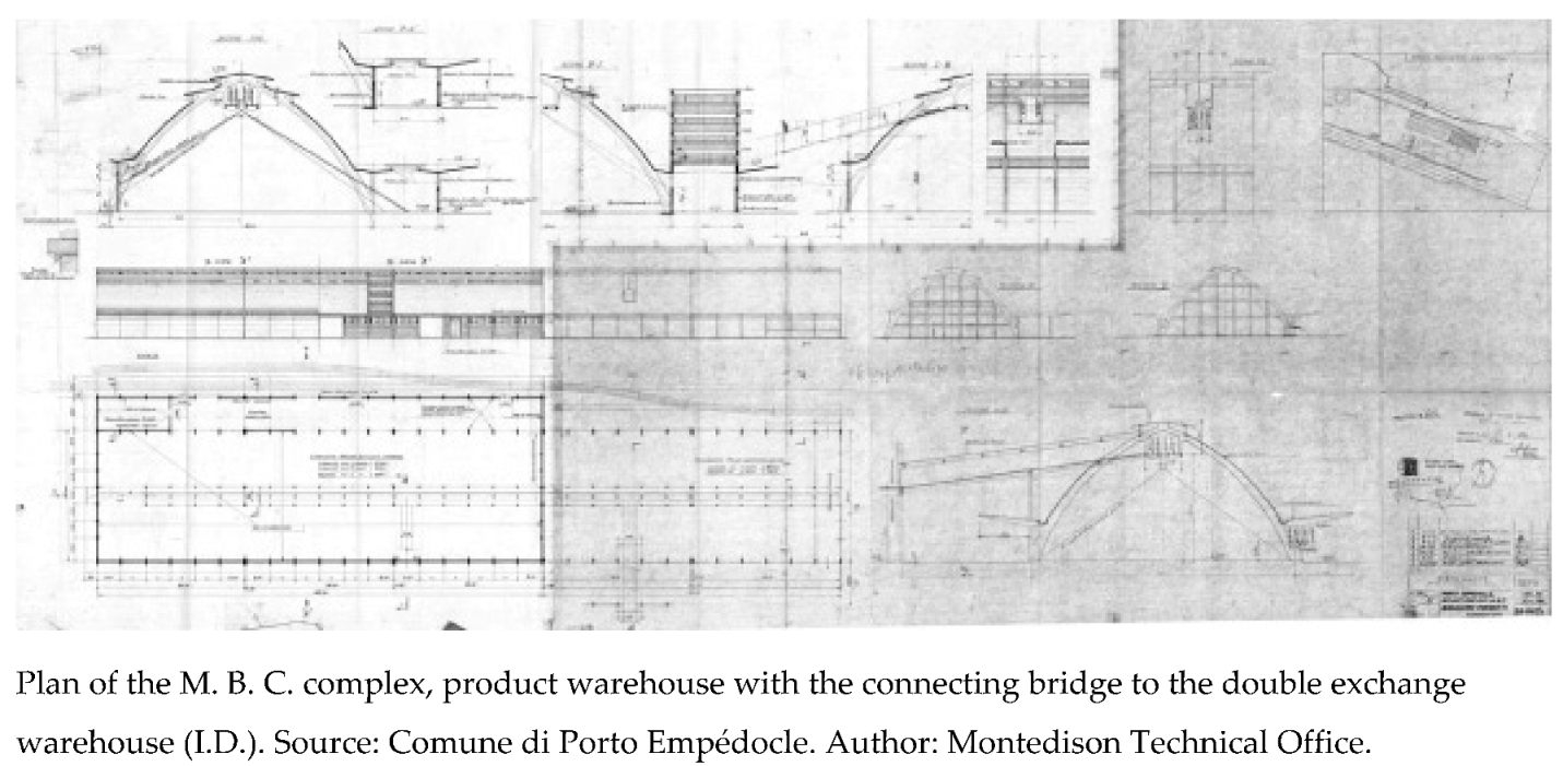
10. Complex Plant M. B. C., Product Warehouse. Plate 2B-547/7. The building was demolished in 2007. North of the double exchange plant was the majestic complex plant, product warehouse. It was a rectangular building that combined two buildings in continuity. The first building, 18 bays long, was intended for the production of complex fertilizers and was characterized by greater width due to the presence, in contact and throughout the length, of a structure intended for various warehouses and services. In continuity, for 12 bays, there was the building intended for superphosphate. As a whole, it was a single building, consisting of 30 aligned bays, each 3 meters wide, with overall dimensions of 32 x 180 meters, and featured a discontinuous arched roof. The building was demolished in 2007.
11. Walkway Connecting Complex Plants M. B. C., Product Warehouse, and Double Exchange Warehouse (D.S.) Plate 2B-547/7. The structure was demolished in 2007. The walkway was a reinforced concrete structure with pillars, beams, and a slab, extending approximately 28 meters, with intermediate support on isolated footing foundations resting directly on the ground. The perimeter closure was made of reinforced concrete, featuring 10 rectangular windows on both sides. The walkway was demolished in 2007.
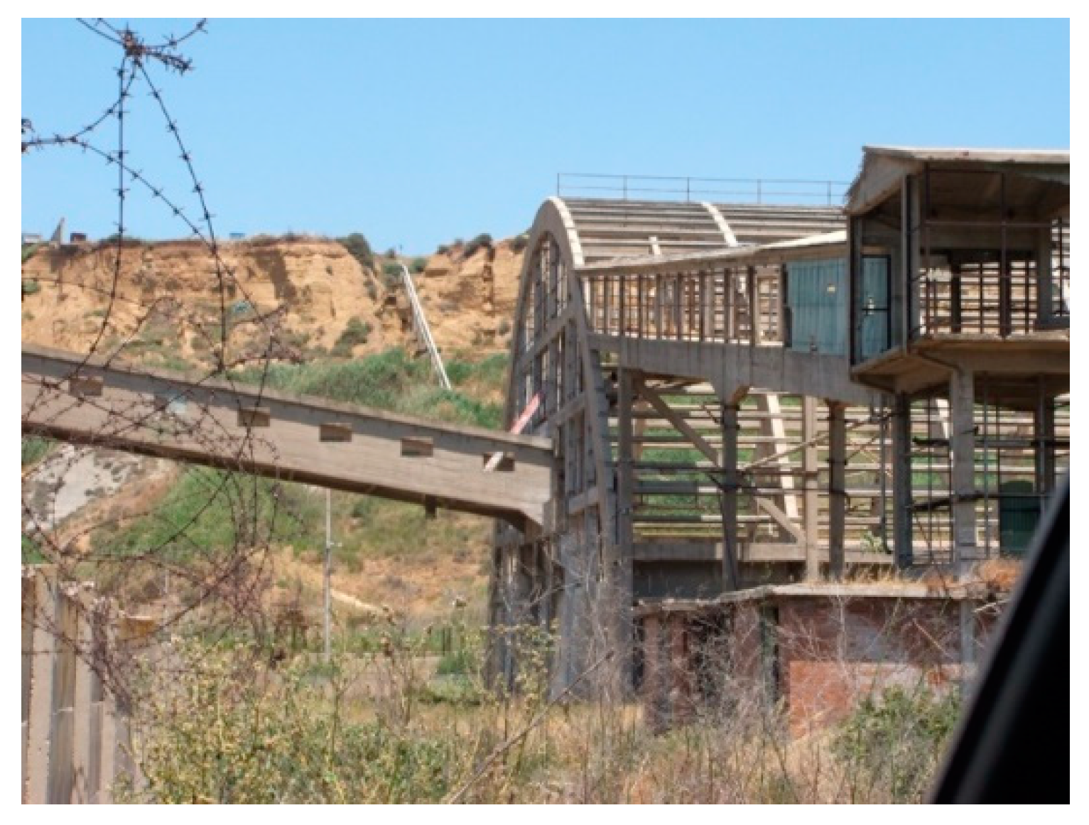
12. Double Exchange Warehouse (D.S.). Project plans not found. The building is existing. East of the complex plant, there is the double exchange warehouse, consisting of a shed measuring 102 x 40 meters in plan, with a maximum height of 20.50 meters. The foundations are made with isolated footings resting on precast reinforced concrete piles 7 meters long, driven in with an appropriate pile driver, and perimeter connecting beams.
The supporting structure consists of 18 arches, with a center distance of 6 meters, connected by longitudinal beams and two eaves beams at a height of +5.70 meters. The roof is made with prefabricated reinforced concrete purlins, on which rests a layer of fiber cement sheets (eternit) and ondulux. The supporting structure is made of pillars, beams, and a brick slab. The perimeter and upper closure was executed with fiber cement and ondulux sheets.
The warehouse, whose connecting roof between the arches has been removed, is currently in an advanced state of decay and is impractical and inaccessible.
13.Walkway between Double Exchange Plant (D.S.) and Double Exchange Warehouse (D.S.). Project plans not found. The structure is existing. The double exchange plant is associated with a double exchange warehouse, to which it is connected by a walkway, still existing, measuring 47.30 meters in reinforced concrete, supported by pillars founded on footings, similar to the neighboring buildings. Originally, the passage was protected by sheets of fiber cement (eternit) and ondulux. The structure is in a state of decay.
14. Double Exchange Plant (D.S.). Plates AK-384-5/4 and AK-384-15/1. The building is existing. Below (to the south) of the complex plant, there is the double exchange plant, positioned parallel to the seafront and near the transverse perimeter wall that divides the entire former industrial area into two further compartments. The building complex consists of the D.S. plant building, the filtration plant, and the electrical control and instrumentation cabin.
The first has an L-shaped plan and is a single building block with a reinforced concrete frame structure, with plan dimensions of 46.00 x 18.00 – 27.00 meters. The roofs are vaulted in lightweight SAP with iron chains. The perimeter closure (where provided) is made of brick masonry, plastered to a smooth finish on the inside and with exposed brick on the outside.
The filtration plant is a rectangular building measuring 15.00 x 8.00 meters (center distance between extreme pillars) with a gutter height of 22.30 meters. Here too, the structure is a reinforced concrete frame with two floors at levels +11.55 and +16.00 meters and a staircase accessing these floors. The roof vault is in lightweight SAP.
Finally, concluding the previously described group of buildings is the rectangular control and instrumentation cabin, measuring 10.05 x 6.40 meters in plan (center distance between extreme pillars), with a gutter height of approximately +11.50 meters. The structure, with pillars and beams, rises over two levels, supported (similar to the other buildings) on foundations with footings connected by wall beams and resting on precast reinforced concrete piles. The entire complex is in a severe state of decay, both in the supporting and non-supporting structures.
15. Potassium Nitrate Plant – Building. Plates AK-375-28, plates 5, 6, 7, 8, and file 1783. The building is existing The building was constructed in the early 1970s as an extension of the double exchange plant (D.S.). The production cycle was aimed at producing fertilizers with high nitrogen, phosphorus, and potassium content through a complex process of potassium nitrate transformation. This was extracted from the solutions produced in the DS plant and underwent a processing cycle to obtain a product for agricultural use and, alternatively, for industrial use. Constructed as independent from the other buildings, due to the delicacy of the processes that had to be carried out within it, the plant was located between the D.S. plant (to the west) and the double warehouse (to the east), intended for product storage. As reported in the project report, the building was specifically spaced 0.60 meters from the D.S. plant and 0.25 meters from the warehouse, with some connection points planned.
The four-story construction has an L-shaped plan, with the front facing the seafront measuring 30.50 meters and a gutter height of 20.10 meters. The western part at the front is designated for stairs, while the back houses rooms for command and control equipment. It develops over four floors and a terrace accessed with walkways and iron stairs from adjacent buildings. Currently, only the reinforced concrete structure of the building remains, entirely exposed and devoid of any perimeter infill closure. From an outside view, it can be observed that the floors at various levels are extensively degraded and collapsed in several areas.
16. Potassium Nitrate Plant – Double Warehouse. Plates AK-375-51, plates 1, 2, 3, 4, 9. The building is existing. Located east of the potassium nitrate production plant, the rectangular building with dimensions of 45.00 x 36.00 meters and a gutter height of 8.50 meters was designed to serve the previously described plant. The building is divided into two areas, considering the differentiated storage of products: the west area was intended for the product for agricultural use, labeled as raw, while the east area was designated for the product for industrial use.
The building was constructed with a reinforced concrete frame structure that supports a metal truss on which sheets of eternit were originally placed. Additionally, on the same roof, there were walkways connecting to the adjacent building (located to the west). The infill walls are made of exposed brick. The building is in a fair state of conservation, as it is still the only one that has been recovered and reused by a craft company (Meccanica Martines).
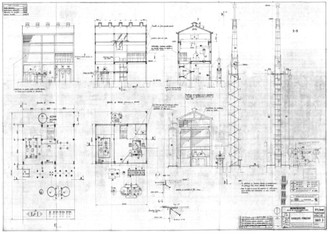
17. Nitric Plant. Plate 56655/5. The buildings were demolished in 2007. The buildings of the nitric plant and the associated water tower, built in the mid-1960s, were located in the southeast, at the extreme limit of the former Montedison area and near the Vetem factory. There were three structures in total: two buildings and the water tower. The two buildings are “Plant 200” (to the west) and a building that housed the boiler (to the east). The first is a reinforced concrete and masonry building called “Plant 200” with dimensions of 35 x 20 meters and a maximum height of about 13.70 meters. The second is a rectangular building with dimensions of 13.00 x 20.00 meters and a height to the eaves line of 15.25 meters. The supporting frame structure is made of reinforced concrete and was elevated on foundation footings resting on precast reinforced concrete piles 7 meters long, driven into the ground with an appropriate pile driver.The building, with two floors above ground, had a trussed roof with a system of five ventilation skylights. The perimeter closures on the first floor were partly in brick masonry, plastered to a smooth finish on the inside and with exposed brick on the outside, and in lightweight materials like ondulux. On the second floor, the perimeter closures were made of solid bricks spaced in horizontal courses to form a perforated wall, allowing ventilation of the floor. The buildings were demolished in 2007.
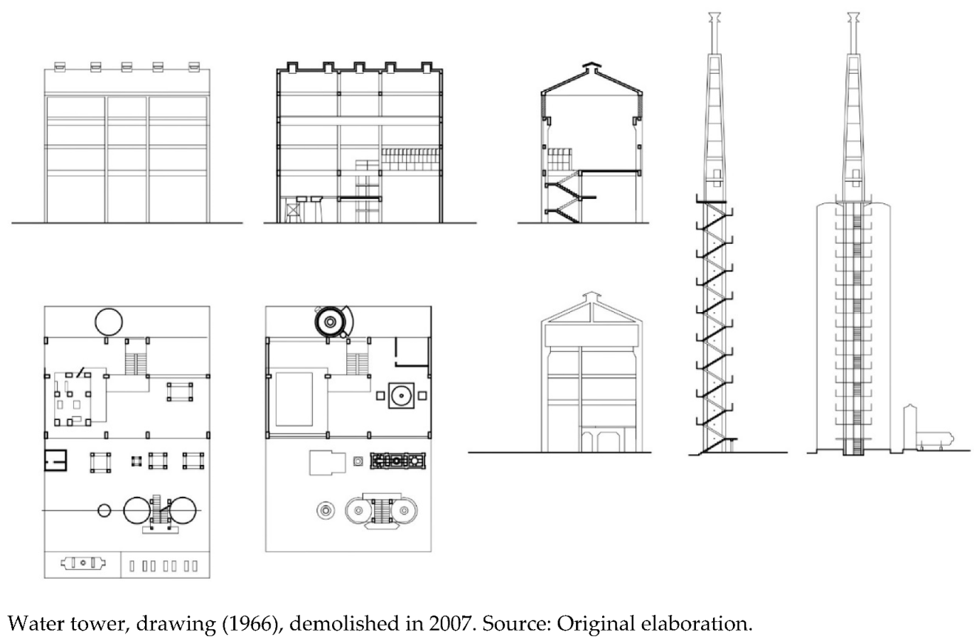
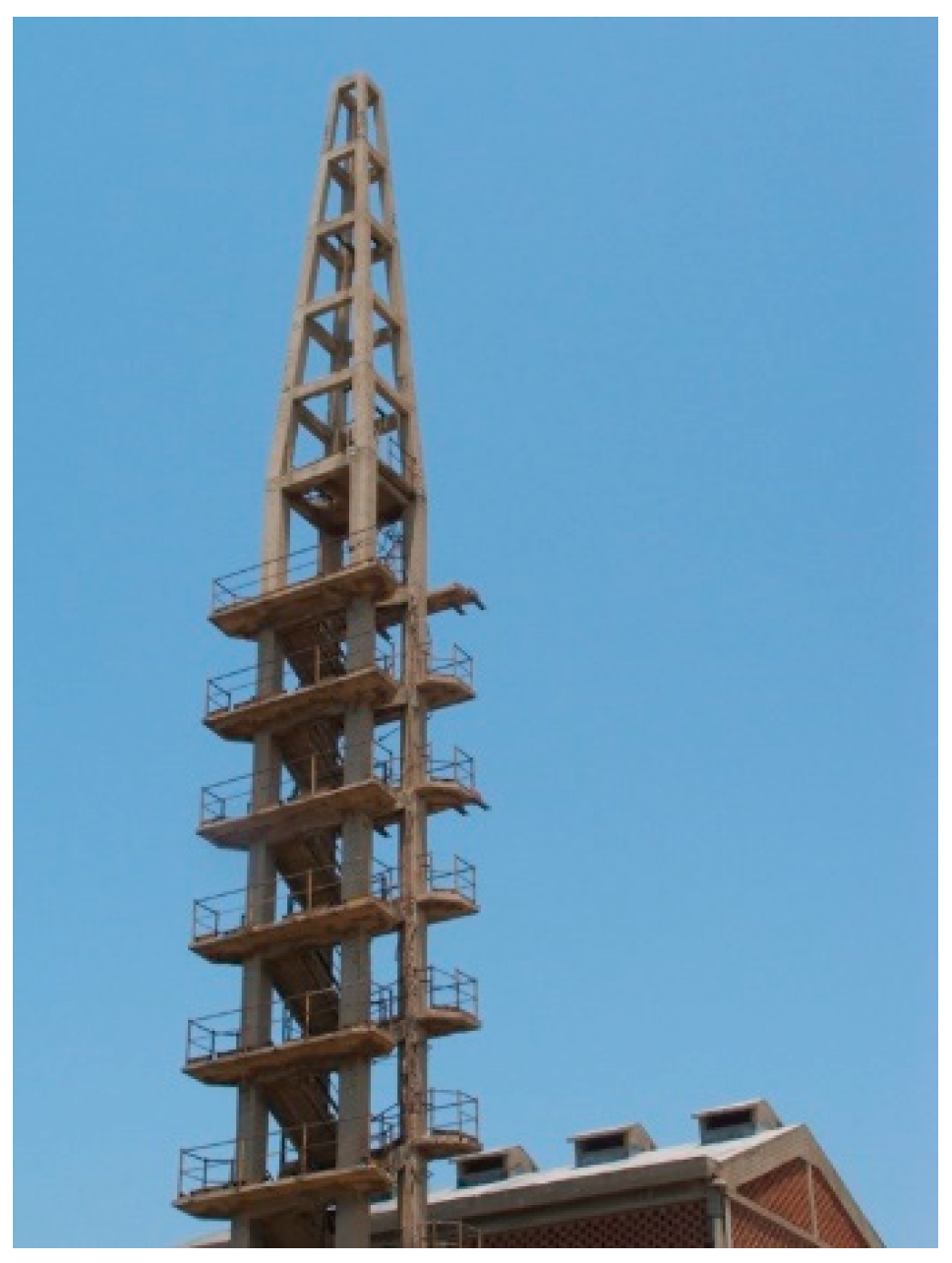
17. Water Tower. Plate 56655/5. The structure was demolished in 2007. Located southeast, at a distance of 16 meters from the nitric plant, was the water tower, a particularly beautiful structure standing 15.50 meters high. The structure was supported by four pillars around which an external staircase developed up to a height of 11.95 meters. The pillars continued their development, narrowing up to a height of 14.80 meters, and concluded at the final height of 15.50 meters. The building was demolished in 2007.
Figure 1. Entrance to the Complex with Phosphate Silos and Warehouses. Source: Own Elaboration.
Preprints 116110 g001
Figure 2. The nitrogenous fertilizers warehouse (superphosphate), demolished in 2007. Source: Own elaboration.
Preprints 116110 g002
Figure 3. Floor plan of the M. B. C. complex, product warehouse with the connecting walkway to the double exchange warehouse (I.D.), demolished in 2007. Source: Own elaboration.
Preprints 116110 g003
Figure 4. The double exchange warehouse (D.I.). Source: Own elaboration.
Preprints 116110 g004
Preprints 116110 i007
The double warehouse and the potassium nitrate plant. Source: Comune di Porto Empédocle. Author: Montedison Technical Office.
Preprints 116110 i008
Preprints 116110 i009
Drawing of the double warehouse and the potassium nitrate plant. Source: Own elaboration
Figure 5. Impianto di nitrato di potassio - doppio stoccaggio. Fonte: Elaborazione propria .
Preprints 116110 g005
Figure 6. Impianto complesso M. B. C., magazzino prodotti. L’edificio è stato demolito nel 2007. Fonte: Elaborazione propria .
Preprints 116110 g006
Preprints 116110 i010
The potassium nitrate plant and the water tower (1966).
Nitrate plant and water tower. The buildings were demolished in 2007. Source: Municipality of Porto Empédocle. Author: Montedison Technical Office.
Preprints 116110 i011
Figure 7. The water tower (1966), demolished in 2007. Source: Original elaboration.
Preprints 116110 g007

2.5. The Potential for Recovery and Industrial Conversion

Abandoned industrial buildings and their surrounding areas are in a constant state of tension between persistence and change, decay and the potential for redevelopment (Sposito, 2012). Two crucial issues emerge over time: the first concerns the decision on the most appropriate intervention, while the second involves the methods and means necessary to ensure the success of the intervention. Since the 1980s, there has been an intense scientific debate, still relevant today, involving various disciplines such as architecture, urban planning, technology, energy, and economic and social sciences. This debate aims to integrate these fields in studying and designing cities for possible urban growth.
Types of Interventions on Abandoned Industrial Buildings
There are various types of interventions possible for an abandoned industrial building
Preprints 116110 i012
Preprints 116110 i013
These conditions have been analyzed using an experimental approach, referring to various significant case studies differentiated by production sector, area size, location, and ownership structure. Other hindering factors include excessive structural degradation and situations of partial dismantling. The redevelopment must be assessed in light of economic and broader planning considerations, including medium- and long-term effects. All these aspects combine to form a grid of parameters useful for evaluating the transformability of an industrial building and/or abandoned area.
Principles for a Design Approach to Functional Conversion
Examining the immense potential for the recovery and reuse of industrial buildings and their surrounding areas, as well as the critical aspects to consider, raises the question of what principles should guide a design approach to functional conversion. One answer might come from successful examples recognized by industry critics. However, it seems useful to start with a reflection on the concept of conservation. Conservation, according to a shared and established view, means selecting from the heritage of disused buildings and sites those characteristics that the community recognizes as part of its identity, values, and history. Conservation involves establishing a continuity with the past within an ever-evolving urban system, and it is a prerequisite for a sustainable future that respects environmental and human and social values.
To preserve traces of the past while meeting new needs, conservation must be viewed as a project of the existing, a transformation through the critical selection of what holds collective value. In this sense, conservation and modification become complementary (Piemontese, 2007). Vittorio Gregotti stated that “there is no new architecture without modification of the existing [...], every architectural operation is increasingly a partial transformation action; even the urban periphery is a place seeking its identity through modification” (1984). Based on these statements, it is possible to develop a new approach to abandoned industrial buildings, which, along with sites of industrial archaeology such as structures, plants, machinery, and archives, represent an important history of the historical and cultural evolution of Western society over the last two centuries (Vitale, 2012). Federica Piemontese asserts that unused industrial fabric is “an indicator of the cyclical transformation of urban fabrics” (2008).

3. Results

3.1. The Importance of Transforming Abandoned Industrial Areas

Cities undergo social and economic changes over time, constantly increasing the need to redesign or regenerate existing spaces so that they remain relevant and meet today’s needs. It is impossible to think of cities as static entities; what was perfect yesterday becomes unusable tomorrow. A notable example is former industrial areas [10], whose evolution and subsequent decommissioning result from a history intertwined with economic and business developments, where a new world demands new products, new production methods, and new production sites. Often, industries are closely tied to the regions they occupy, making these areas even more important and deserving of a second life, preferably serving the same region [11]. When a large factory is decommissioned, it presents an opportunity to transform that space and give it a new identity, so it can offer experiences, services, recreational spaces, or, why not, new residences. The redevelopment of abandoned areas can be at the center of a diverse debate involving technicians, designers, administrations, and even the citizens themselves. Regenerating a former industrial area [12] means revitalizing an entire area, enriching the city it is located in, and adding new value to the territory [13].

3.2. Conversion Policies for Former Industrial Areas

The choice to implement urban policies aimed at giving new functions to abandoned spaces constitutes a premise for the sustainable regeneration of territories. The redevelopment of neglected areas represents a significant opportunity for transformation and change in our cities, involving various disciplines, experiences, and technologies. This leads to the creation of new and artistic spatial designs, sustainable spaces, and new social and employment opportunities for the cities of the future. There are some noteworthy examples where environmental sustainability in public spaces achieves impressive results. For instance, Barcelona’s photovoltaic plaza and Madrid’s Ecoboulevard demonstrate a compelling balance between technical and technological aspects and the quality of spaces and buildings. The current economic and environmental difficulties stimulate research and innovative experimentation to rethink unused spaces and the city/periphery relationship, adding value and significance to these locations.As Magnaghi (2000) aptly points out: “The culture that has interpreted open spaces and historic territories as residual (without value or constraints) has contributed to major territorial and environmental disasters. The reconstruction of cities must proceed from a conceptual reversal (in analysis and design): the ‘voids,’ residual open spaces and remnants, become the generative figures of the new territorial and urban order. Reinterpreted as ecosystems, they organize and return virtuous forms and proportions.

4. Discussion

In Sicily, in addition to the Porto Empedocle plant, Montedison also owned another facility in Campofranco, in the Agrigento hinterland. Established between 1958 and 1959 and inaugurated the following year, it was the world’s first plant of its kind, utilizing technology developed by Montecatini itself to produce over 200,000 tons of potassium sulfate annually. When the kainite deposits in San Cataldo were exhausted, the plant was taken over in the early 1980s by a second public-private company, Italkali, which supplied the facility with minerals extracted from other locations on the island. This continued until 1991, when the plant was permanently closed and completely abandoned. After twenty years of total neglect, the former industrial facility still retains all the original equipment and machinery from the era, which would merit a serious recovery and valorization effort. Inside the two parabolic structures, conveyor belts and scraper machines are still present. These facts remind us that the rapid changes in the production and labor markets should make us realize that the fate of industrial spaces and areas must be planned with foresight and anticipation of the ongoing transformations in the labor and production world, and sometimes anticipate them, in order to create sustainable and competitive development models, potentially as business incubators and services for advanced tertiary sectors.
In recent years, in the public debate surrounding the PNRR (National Recovery and Resilience Plan), the recovery of disused areas represents a unique opportunity among project actions to advance interventions for the recovery and remediation of abandoned or unused industrial areas and achieve the following objectives: adhering to the principle of “do no significant harm” (DNSH), initiating the Green Revolution and ecological transition, advancing sustainable mobility infrastructure, and contributing to climate goals in line with Next Generation EU initiatives. These actions will aim to create a circular economy and a development concept that, on the one hand, improves infrastructure, mobility, logistics, and quality housing, and on the other, lays the foundation for a more prosperous, equitable, sustainable, and resilient country.

5. Conclusions

To conclude, it is clear that the identity of a former industrial area is something that cannot be captured by a single, unchanging image: each area presents specific characteristics that distinguish it from any other situation. The territorial context and the relationships the area establishes with it vary; the balance between built and unbuilt spaces changes, as does the location (in the outskirts, on the waterfront, etc.), and so on. Different situations come with specific opportunities and needs for redevelopment. Although each recovery intervention is tied to the specifics of the case, some general criteria for an appropriate design approach can be outlined: 1) the need for a multidisciplinary and integrated intervention methodology; 2) involvement and cooperation among multiple parties (public and private, creation of ad hoc bodies); 3) defining uses that are compatible both in relation to the potential and characteristics of the buildings (to avoid unreasonable adaptations) and with respect to the surrounding context—physical as well as social, cultural, economic—and current urban planning regulations; 4) differentiation of uses to counteract mono-functionality and create active and vibrant complexes throughout the day and year; 5) preservation, through knowledge and critical selection, of the original features, materials, construction systems, as well as machinery and other artifacts that document industrial civilization; 6) integration of traditional and innovative technologies to leverage the intrinsic potential of the buildings; 7) experimentation with new technologies and materials for energy efficiency; 8) design oriented towards the fundamental principles of eco-compatibility and sustainability, also considering the management phase; 9) recognition of new interventions in relation to the existing conditions; 10) enhancement of the connective spaces between industrial buildings, which can serve as public spaces, thus breaking down old barriers and allowing for direct, daily use by the community, mobility, and social interaction. Reuse and functional conversion can represent, for the various reasons examined in this contribution, the suitable solution both for recovering such a valuable heritage of industrial civilization and as a catalyst for development and urban regeneration, with the goal of returning these spaces to the community.

References

  1. AA.VV. (1953). The Porto Empedocle Plant for the Production of High-Concentration Phosphate Fertilizers. Milan.
  2. AA.VV. (1986). Bicocca Project, Catalogue of the Homonymous Exhibition. Milan.
  3. Archeologia Industriale (1977). “Casabella”, 422-423.
  4. Arbizzani, E. , & Materazzi, G. (2012). The Redevelopment of Disused Industrial Areas. (h)ortus, 62.
  5. Arca Petrucci, M. , & Dansero, E. (1995). Disused Areas: Between Degradation and Environmental Redevelopment. Geotema, 3, 69-78.
  6. Balzani, A. (1990). Montecity: Project and Plan. Milan.
  7. Battisti, E. (1978). Industrial Archeology. “Italia Nostra”, XIX, 158.
  8. Bilello, F. (1980). Porto Empedocle and Its History. Ed. Sava, Agrigento.
  9. Bondonio, A. , & Callegari, G. (2005). The Reuse of Disused Industrial Areas in Italy. Florence.
  10. Camilleri, A. , & Insolera, I. (2007). The Eye and the Memory: Porto Empedocle 1950. Rome.
  11. Caputo, P. (1990). A Project for La Spezia: The IP Area and the City's Fate. Milan.
  12. Castronovo, V. , & Greco, A. (1993). Prometheus: Places and Spaces of Work 1872-1992. Milan.
  13. Chinello, C. (1979). Porto Marghera 1902-1976: The Origins of Venice’s Problem. Venice.
  14. Dalmine, S.p.A. (1956). General Catalogue. Milan.
  15. Dansero, E. (1993). Inside the Voids: Industrial Displacement and Urban Transformations in Turin. Turin.
  16. Danserio, E. , Giaimo, C., & Spaziante, A. (2006). If the Voids Are Filled: Disused Industrial Areas, Case Studies. Milan.
  17. Gargiulo, C. (2004). The Bagnoli Case. Naples.
  18. Gibilaro, C. (1980). Preliminary Proposal for the Creation of the Industrial Zone of Agrigento-Porto Empedocle and the Related Port Plan. Porto Empedocle.
  19. Gibilaro, C. (1980). Proposals for a Consortium to Manage an Experimental Industrial Area and the Enhancement of the Porto Empedocle Port. Porto Empedocle.
  20. Gregotti, V. (1984). “Modification”. Casabella: Architecture as Modification. 498(9).
  21. Martelli, A. (2005). On the Conditions Influencing Transformability and Hindering the Redevelopment of Disused Industrial Areas [PhD Thesis]. Rome: University of Rome “La Sapienza”.
  22. Negri, A. (1977). Industrial Archeology. In History of Italian Industry. Milan.
  23. Piva, A. (1975). The Stucky Mill in Venice. In A. Piva, P. Caputo, & C. Fazzini, The Architecture of Work: Industrial Archeology and Design. Venice.
  24. Santi, G. (1964). Industrial Settlements in the Transformation of Urban Structures in Milan. Milan.
  25. Trupiano, U. Porto Empedocle: Past and Present. (Knowing the Territory, Series Directed by), Ed. Studio Editoria Sud, Agrigento.

Notes

1
AUDIS is the Association of Abandoned Urban Areas, based in Bologna, Italy. Its goal is to address the demand for spaces and functions that cities continue to generate while simultaneously stressing the urgent need to stop wasting territorial resources. The association highlights how abandoned areas are a strategic factor in the process of regeneration and development of contemporary cities. The AUDIS Charter for Urban Regeneration is the result of fifteen years of work and reflection by the Association, offering a set of ideas that have proven effective as a reference point for public and private entities operating within the city. The AUDIS Charter proposes guiding principles for city regeneration through the transformation of abandoned or decommissioned areas.
2
Literature contains numerous terms referring to disused areas and, by extension, to abandoned industrial sites and their buildings. Terms with sometimes different connotations include "vulnerable areas," "underutilized areas," "interstitial areas," "urban voids," as well as "liberated spaces," "resource containers," and "malleable areas," which have a positive meaning related to their potential for transformation. In Italy, the Environmental Code (Legislative Decree No. 152 of 2006, Article 240) defines a disused site as "a location where production activities have ceased." The site can be classified as "non-contaminated," "contaminated," or "potentially contaminated" based on threshold values of contamination (CSC) and risk (CSR). Internationally, disused industrial areas are known as 'brownfields.' The CLARINET working group, funded by the European Commission, defines brownfields as: 'sites that 1) have been affected by previous uses of the site and surrounding land, 2) are abandoned or underutilized, 3) present real or perceived contamination problems, 4) are primarily located in developed urban areas, 5) require intervention to bring them to a beneficial use.' In the United States, the EPA (Environmental Protection Agency) defines them as 'properties for which expansion, redevelopment, or reuse may be complicated by the presence or potential presence of a hazardous substance, pollutant, or contaminant.'
3
The term Fordism is used to describe a specific production system primarily based on the use of assembly line technology to increase productivity. The term was coined around the 1930s to describe the success achieved in the automotive industry by American industrialist Henry Ford from 1913. The system, inspired by Frederick Taylor’s theories, spread so widely in manufacturing that it significantly revolutionized production organization on a global scale, becoming one of the fundamental pillars of the 20th-century economy, with substantial social influence. By the 1970s, this model faced crises due to both economic and technological reasons (automation and informatization of production), leading to the emergence of a new system, post-Fordism, characterized by flexibility in production and management, administrative rationalization, workforce reduction, and orientation towards a global market.
4
CLARINET (Contaminated Land Rehabilitation Network for Environmental Technologies) is a working group established by the European Commission, DG Research, consisting of institutions from 16 European countries, dedicated to identifying policies and strategies for the rehabilitation of disused industrial areas.
5
See Sustainable Regeneration of Disused Industrial Areas: Report of the CABERNET Network, University of Nottingham, 2006, www.cabernet.org.uk.
6
Akragas was a joint-stock company based in Palermo. The first stone of the plant was laid on June 3, 1953. The estimated time for the construction and operation of the plant, considering the complexities of the facilities, was about two years. A few years later, the industrial complex was acquired by the Montedison group, which managed it until its closure in 1984
7
Montecatini was founded in 1888 in Montecatini Val di Cecina (PI) to exploit local copper mines. In the 1910s, it entered the chemical sector and, through patents and acquisitions, became Italy's largest chemical company, almost monopolizing some products such as sulfuric acid, fertilizers, and dyes (through its subsidiary ACNA). In 1936, in collaboration with AGIP, it created Anic (National Hydrogenation Fuel Company), aiming to produce synthetic gasoline, which would be the nucleus of the Italian petrochemical industry. Edison was founded in Milan in 1895 and was one of the first Italian companies to utilize hydroelectric power, which was fundamental to Italy's first industrialization, building dams along the Alpine arc, especially in Lombardy. By the early 20th century, Edison was already one of the dominant industrial groups in Italy, sharing control of the electricity market in northern Italy with SIP, concentrated in Piedmont and Liguria, and SADE, strong in the northeast. Montedison was formed in 1966 from the merger of Montecatini and Edison. Montecatini Edison S.p.A., from 1966 to 1969, later abbreviated to Montedison S.p.A., was a major Italian industrial-financial group, known by this name until 2002. Primarily active in the chemical sector, it also had interests in numerous other sectors (pharmaceutical, energy, agribusiness, insurance, publishing). Its history was marked by dualism with the public chemical sector of ENI, the influence of the power block centered around Mediobanca, and a fragmented shareholding structure, often lacking a controlling shareholder and subject to stock market fluctuations. Montedison's trajectory, from being one of the world's largest chemical groups to a gradual downsizing, is seen by many commentators as an example of Italy's industrial 'decline,' unable to produce multinational corporations of an adequate 'size' to compete on global markets.
8
Italo Insolera, architect, urban planner, and photographer (Turin 1929 - Rome 2012).
9
The assignment to architect Italo Insolera was ordered by the Civil Engineering Disciplinary of Agrigento on April 28, 1956. The project was approved in 1957.
10
The term "ownership structure" refers to the characteristics of the dimension and fragmentation of ownership, the type of ownership (private, public, mixed), and the entrepreneurial profile.
11
Castronovo, V., & Greco, A. (1993). Prometheus: Places and Spaces of Work 1872-1992. Electa-Sipi, Milan.
12
Danserio, E., Giaimo, C., & Spaziante, A. (2006). If the Voids Are Filled: Disused Industrial Areas, Case Studies. Milan.
13
Bondonio, A., & Callegari, G. (2005). The Reuse of Disused Industrial Areas in Italy. Florence
Disclaimer/Publisher’s Note: The statements, opinions and data contained in all publications are solely those of the individual author(s) and contributor(s) and not of MDPI and/or the editor(s). MDPI and/or the editor(s) disclaim responsibility for any injury to people or property resulting from any ideas, methods, instructions or products referred to in the content.
Copyright: This open access article is published under a Creative Commons CC BY 4.0 license, which permit the free download, distribution, and reuse, provided that the author and preprint are cited in any reuse.
Prerpints.org logo

Preprints.org is a free preprint server supported by MDPI in Basel, Switzerland.

Subscribe

© 2024 MDPI (Basel, Switzerland) unless otherwise stated