
Submitted:
30 August 2024
Posted:
02 September 2024
You are already at the latest version
Abstract
A theoretical framework for agricultural landscape pattern transitions in rural areas is proposed to fill the gap of current research with an empirical study in the Alabata farm settlement in Ogun State, Southwest Nigeria. Adopting the use of ArcGIS 10.8 and Surfer 27.3 to calculate the surface area and volume of the ground surface degraded and exposed to harsh weather conditions due to both natural and man-made anthropogenic activities causing runoffs and continuous soil erosion, which has affected agricultural production and sent some of the farmers packing and abandoning their farmlands. The farm settlement within the total sampled frame area of 1.50 km² covers a total distance of 5.11 km. The sample frame was divided into 36 frames with similar ecological terrain and soil types, which fell into either identified soil types 1 and 2. The study completed a questionnaire onsite using three major criteria. Only 23 farmers responded positively to the few questions with farmers either living on the farm or working as hired laborers on-site at the visit. The transition characteristics of agricultural landscape patterns as represented in abandoned land, and orchards are analyzed from a local perspective.
Keywords:
agricultural landscapes
; agricultural growth plans
; biodiversity niches
; resilient communities
; rural neighborhoods
1. Introduction
The essential signals for comprehending the parts of rural regional systems are geographical trends and the factors that influence rural communities [1,2]. Nonetheless, scant research will be done on the features of rural communities as they relate to equitable growth and territorial rehabilitation from an agricultural viewpoint. Employing data from satellite imagery and isolated communities to analyze the form, physical, and epidemiological aspects of rural neighborhoods with geospatial examination, slope traverses, and geospatial assessment factors [3]. The primary locations in rural regions where residents live, work, and engage in social events are small towns, and their services are connected to the standard of living for countryside inhabitants and fulfill the primary purposes of rural life and output [3]. Slanting cropland complete transformation, and partly abandonment are all of the ways whereby rural area layout shifts within the farming range in the study region expressed as in the distributions of the hilly rural setting are shown at numerous stages of evolution by each transition mode due to natural occurrence [3,4]. Socioeconomic considerations play a crucial role in driving the transformation of the agricultural landscape pattern in a given location [3,4,5]. This characteristic is defined as the shift from the conventional evenly distributed grain-planting landscape, and the study's findings highlight how the nation's countryside populations have distinctively evolved their agricultural landscape patterns. This pattern has been threatened over the years by continuous rainwater runoffs and has caused the topographic erosion that has washed away the topsoil of the farm settlements into the Ogun River and the seasonal stream just behind the Alabata farm settlement.
The accumulation features are formed by the interplay of economic, social, and cultural variables during the establishment and growth of rural communities. Thus, the essential features and trajectory of the evolution of agricultural spaces can be reflected in the spatial distribution pattern and linkage with the natural and social settings of the region [5]. To properly formulate physical growth plans and support suburban equitable growth, it is essential to investigate the distribution of assets and factors that drive rural settlements as well as optimize the spatial structure and scientific and rational layout [5,6]. This assessment has significance in terms of theory, as well as the reality of built-up villages, specialized villages, and empty villages, are just a few of the rebuilding forms that have emerged as a result of Nigeria's economy's explosive growth and the country's growing cities. The challenges of dispersed and disorganized farming communities, thorough preparation, creating fresh towns and ignoring traditional ones, " broadening while participating removal in there," overstepping on cultivable land, and declining biodiversity have all gained prominence at the precise same time as the spatial distribution scale and structure of rural settlements have changed substantially [7,8]. Villages in rural areas will continue to be the primary dwelling type for farmers to engage in agricultural production and living operations degree of expanding cities has risen substantially [7,8,9]. As a result, the Federal Government highlights that to achieve excellent growth and income, farming, and the countryside should be given priority. Farmers, as well as agricultural and rural areas, are basic problems linked with the national economy [10]. The National Strategy Plan for Rural Redevelopment (2018–2022) calls for "establishing an exquisite landscape" and "maximizing the spatial arrangement of output, living, and ecology in rural regions [4,7,8,9]." This offers a fresh opportunity for development that will enable the restoration of rural living and production areas as well as the attainment of excellent, economically viable growth [10]. The basis of rural planning and rational layout, as well as the main topics of ongoing research in developing rural areas and the actualization of rural redevelopment strategies, are the scientific evaluation of choosing appropriate remote rural sites and the appropriate utilization of agricultural assets [10,11].
A Review of Rural Agricultural Landscape and Rural Resilience
Physical development and control of rural natural environments have received substantial funding as well as personnel since the detailed alleviating hunger plan was put into place [5,6,9-11]. Sustainable movement, a decrease in hardship, and displacement to other locations, including the completion of agricultural transportation projects have all occurred. In impoverished rural regions, circumstances for development and living have substantially improved, and the spatial arrangement of rural communities has undergone major alteration [10]. To assess whether rural communities in the Alabata regions are suitable for reflecting the current development situation in rural Ogun State in a way that is both reasonable along reasonable after addressing impoverished rural communities and neighborhood inequality in general. The goal of this study is to stimulate further research into an operational comprehension of the sustainable landscape in rural regions. The establishment of environmentally responsible scenery in remote regions; the restoration of rural landscapes; tourism and rural development; built environment and health in rural areas; revitalizing traditional villages; and ecology of biological diversity in rural locales are some of the topics covered by upcoming concepts and innovations. Moreover, the link underlying production and specific property evaluation characteristics has not been sufficiently measured or integrated into current area assessments. To standardize and enhance farmland evaluation approaches, it is expected the outcome of this research will well as support guiding in-field methodology, legislative proposals, and the most efficient tactics. It is easy to observe that the versatility and geographical structure of rural communities are perennially popular subjects in rural geography research [10,11,12]. The creation, as well as placement of rural towns, were given more consideration in the initial studies on the spatial pattern of rural communities. The land use status data and the social and economic data on rural settlements in the study area for the year 2023 in November-December were obtained through field visits and interviews. Additionally, the primary role concept was used to separate the kinds of land use within the countryside communities; these divisions, a land diverse uses indicator was set up for the diversity of varied land use in the suburban communities; furthermore, a thorough investigation was conducted into the influences of innate the environment, society, economy and other factors on mixed land use [1,2,3,10,11,12]. The findings revealed that farm settlements expanded along floodplains, while vacant property broadened at high highlands, reducing decreased falling agrarian land and this process provides neighborhood surroundings distinctions beginning at the level of the community.
2. Literature Review
The collaboration of rural dwellers with their underlying ecological, economic, social, and cultural contexts shapes rural communities as centers of production and living [13]. The arrangement of things in rural villages, as the primary hub for the rural populace, demonstrates the interplay involving people and the natural setting [13]. Rural populations select appropriate sites for township building by taking into account the overall effect of natural endowments, convenient production, customs, historical roots, and other considerations [13,14].
The patterns of human-land interactions in various locations and phases may be seen via research on the magnitude, form, distribution, and structure of rural communities as well as their regional differentiation and pattern evolution [15]. Due to the relatively fast growth of industrial growth, major shifts have occurred in the underlying setting, agricultural way of life, economic framework, employment in agriculture approach, and geographical layout [15,16]. Villages are currently complex geographical units having several functions, such as production, dwelling, and ecological, rather than just the one dwelling purpose that serves as the primary spatial unit [17]. The field of agriculture is where the idea of multifunctionality initially emerged and the multipurpose in agricultural areas refers to a broad variety of possible traits, mainly associated with land use and social aspects [16,17,18].
The of rural villages, as physical transportation strongly linked to human activities and land use structure in rural areas, can be defined as the ability to provide hygienic goods and services to meet the requirements of those who live there both now and, in the future, using self-operating and interacting with different platforms [19]. Figure 1 illustrates the importance of investigating the plurality, complexity, and flexibility of traditional community roles for long-term growth and agricultural restoration.
Viewed as a paradigm predicated on a harmonious development of economy, culture, people, and assets is a vital factor behind the financial and social development of a nation [20]. Although studies on the sustainable growth of rural neighborhoods in hilly areas are scarce, agricultural land is a significant portion of the nation and its healthy growth has received emphasis [21]. In nations with low or middle incomes today, almost 65% of the entire population resides in rural regions [22]. Reaching all seventeen Sustainable Development Goals (SDGs) that have been endorsed by the United Nations requires substantial progress in agricultural growth [2,7–9, 18–21]. However, the preservation of natural capital is being threatened by the present rural development plans, which puts the continued existence of rural areas in jeopardy [17,18,19,20,21,22].
The foundation of rural renewable energy initiatives has been thought to be the long-term cooperation of several parties to create a resilient environment within agricultural regions that supports rural production and life activities as well as the processes of nature [22,23,24,25]. In light of urban-rural integration, climate change, and carbon neutrality objectives, agricultural land is becoming increasingly complicated, making it necessary for multidisciplinary studies to collaborate to determine how to develop a healthy environment in these places [26]. Theoretical understanding, firsthand knowledge, and tactics continue to lag behind agricultural areas in accomplishing the aim of an ecological terrain [25,26,27,28,29,30]. The main claim is that as agricultural areas differ significantly in terms of their socioeconomic performance, terrain, weather, and level of advancement, appropriate environmentally friendly remedies must be carefully considered [31,32,33,34,35]. Nigerian land for agriculture is experiencing increasing strain to provide more food from a decreasing amount of land because more land is being put to waste. The idea involves strategic land acquisition and land reform, which aims to change the rural environment to one that is more agricultural [35]. About 20% of Nigeria is thought to be suitable for dryland farming and to ensure some degree of food security for the country in the future, it is crucial to preserve farmland and make efficient use of these limited resources [35,36,37,38,39]. A crucial instrument for achieving this objective is the appraisal of Alabata agricultural land considering that Nigerian farm-level evaluations, the level at which choices about the land release are decided, and the advancement of updated or new land appraisal procedures have halted in the recent past.
2.1. Rural Settlements, Livability Assessment Index in View
The first is to investigate the spatial differentiation and evolution of the magnitude, dispersion, and shape of rural villages [40]. The subsequent part will cover the mechanisms and laws governing the growth and development of isolated communities as a result of various human, financial, and natural factors [40,41,42,43]. Additionally, it will cover the layout optimization and spatial reconstruction of rural settlements using a variety of techniques, taking into account the multifunctionality of rural areas on three different increases: community subject matter, habitation, and which took according to some academics, suburban settlements serve several purposes at the village level, including residential, commercial, recreational, and agricultural revenue [44]. Other researchers separated the village's multifunction into three categories: output, existence, and biological. These categories relied on the village's physical component features and the usage of land configuration [43,45,46,47,48,49,50].
Scholars have mostly examined the evolution with the diversification of rural community activities at the resolution scale via the lenses of supply-demand equilibrium and urban-rural gradients derived from internal land-use structure [51]. Scholars have also stressed that, at a small scale, rural farmhouses serve several purposes, including social security, profit, and retaining farmers' demands [44,45,46,47,51,52,53]. Concerns have also been raised regarding the rural residences' production, and environmental roles, and a few academics have also focused on the connection connecting spatial pattern and variety, and their research has revealed an affinity of sorts connecting the geographic spread of rural communities and their agricultural production task [35,36,37,38,39,54]. The way towns and villages expand explains the symbiotic connection between dwelling and industrialization at multiple spatial scales and has a significant influence on the biological environment and the relationship between rural housing and industrial growth [54,55,56]. More significantly, compared to plain towns, the impact of environmental terrain on the size, dispersion, and composition of mountain villages is frequently larger. Topographic variables have a major role in shaping the development and evolution of the spatial pattern and multifunctionality of rural communities in the area by limiting human use and alteration of land assets in their natural state [13,18,21]. Multiple research investigations have proven that the geographic grading of mountains, hills, and plains has a substantial impact on the territorial geometry of agricultural areas [35,36,37,38,39,57].
There are notable horizontal grading features in the geographic distribution of rural communities in hilly terrain [57]. The three main geographic factors—slope, component, and altitude—have a significant impact on the size, transportation, and form of rural communities [57,58]. There are notable directivities in the geographical arrangement of rural communities, including low-lying land with modest relief amplitude, moderate slope, and low terrain niche index. Therefore, while examining the spatial structure and multifunction of rural communities in mountainous areas, it is very important to take the important topographic elements into account [59,60,61]. This article examines the vulnerability of rural communities from the standpoint of geological disasters and examines the mechanisms through which elements associated with geological disasters affect the social economy, production, quality of life, and environmental conditions of towns and villages.
Research has examined how earthquakes and other natural disasters affect the social vulnerability of rural communities in Alabata. Additionally, an assessment methodology for the social vulnerability of rural communities in geological disaster-prone areas has been developed. The majority of the environmental parameters related to geological disasters are included by this type of study in the vulnerability evaluation index system; however, regional communities' spatial and socioeconomic aspects are not included. Simultaneously, this type of vulnerability study on rural communities assesses the resilience of rural communities against social and economic collapse following geological catastrophes, but it ignores the resilience of the physical environment surrounding rural settlements against natural hazards and the physical layout of rural communities and its social and economic components resilience to emergencies.
The objective of this research is to investigate specific features in agricultural communities that can withstand the damaging effects of environmental disasters and to develop a set of indicators for evaluating the geographical fragility of these communities. It makes an effort to suggest ways to lessen the negative impacts of geological catastrophes on agricultural communities via the application of geometric and formulating techniques.
2.2. Rural Settlements and Livability Assessment
The current study aims to offer solutions for reducing the spatial susceptibility of villages from the perspective of the natural environment. GPS-based ecosystem suggests methods to reduce the spatial vulnerability of rural communities. To modify the anticipated storms of these sizable, geographically susceptible farming populations, a mechanism for arriving in observation with real-time input is set up to evaluate precipitation through regions with high vulnerability [62,63,64]. This system is then combined with artificial rainfall reduction technological devices to protect intact hydrological routes and stream connections, control the originating location of rainstorms, and restore forests and woods to reduce the probability of a large amount of rainwater falling in a short amount of time [23,24,25,26,27,65].
Reducing the pace of eroding soil in areas of greatest risk is another important tactic for reducing the spatial sensitivity of rural populations. This entails building hills and canals, planting new plants, and slowing down or stopping the flow of water by keeping the soil moist will improve its cohesion and resilience to sinking [66]. Wood collected for the conservation of the environment will control and monitor water flow, reducing soil and water loss. In the hilly and rocky regions of Ogun agricultural towns and villages, strategically positioned watering connections, reduced groundwater stimulation, and reduced water-induced degradation are additional tactics that can decrease the pace of soil degradation and, thus, the area of rural settlements. The techniques of leveling the terrain and reinforcing geotechnical structures can also be used to eliminate concealed geophysical catastrophe sites [67]. Smart devices are used to continuously track the threat of tucked scientific tragedy points in real-time in the areas where engineering measures are unable to eliminate them. This allows for the prompt reporting of disasters to the appropriate departments and the mitigation of buried geological history disaster points, which lessens the impact and the spatial vulnerability of rural settlements. Farm management officials should aim to minimize probable geological hazards when choosing a location for rural communities in high-vulnerability zones, and farming operations shouldn't be established beneath slopes with instability [67,68].
In Alabata's mountainous regions, rural villages should be situated in a level space amongst mountain ranges, appropriately separated from the valley of the river, and away from steep inclines and hillsides. Rural communities may manage their border shape by being positioned in a way that minimizes their territorial susceptibility and protects them from the negative effects of catastrophes of nature on their geospatial integrity and habitation viability [68]. To the extent is achievable, the community-generating boundaries of rural communities should be laid out linearly under the assumption that there will be enough land use. This will minimize bends, and that could decrease the overall amount of small enclosed spaces in the settlements and, ultimately, lower the rescue effort dead point in the event of a physical tragedy. The study offers strong evidence for measuring the link between the terrain of the plain area and the geographic distribution of farmland communities, as well as for enhancing agricultural communities.
3. Methodology
This Alabata is a typical ecologically vulnerable location, situated in the southwest karst mountain region of Ogun State. It has a limited carrying capacity for land, a tiny biological environment, poorly coordinated social and economic development, and a pronounced conflict between people and land. The present investigation looks at the relationship between the distribution characteristics of rural settlements and various environmental factors based on an analysis of the spatial distribution characteristics of rural settlements, taking into consideration the spatial heterogeneity of geographical factors and the relationships between influencing factors. Alabata has a geographic position of 3.4840606033730346, 7.251688123182648 with a total area of 20.73 km² (8.00 mi²) and a total distance of 20.02 km (12.44 mi). This study employed a qualitative and geospatial analysis approach to evaluate the correlation between the distribution characteristics of rural settlements and different environmental factors. Additionally, a ranking scheme was developed to assess the suitability of farm colonies and identify critical issues that must be resolved quickly to promote high-quality development and rural revitalization in Ogun State. The study's findings will serve as a guide for the restoration and optimization of rural cities' spatial layout within the investigation area. Responding to the following study questions: How do various ecological elements interact with Ogun State's rural settlements in terms of their geographical distribution? What is an objective, analytical way to assess the appropriateness of current agricultural villages?
The study provides an important means of promoting the intensive and efficient use of land resources and stimulating endogenous development power in rural areas. the land use status data and the social and economic data on rural settlements in the study area for the year 2023 in November-December were obtained through field visits and interviews. Additionally, the primary role concept was used to separate the kinds of land use within the countryside communities; these divisions, a land diverse uses indicator was set up for the diversity of varied land use in the suburban communities; furthermore, a thorough investigation was conducted into the influences of innate the environment, society, economy and other factors on mixed land use. Alabata, with its uneven topography, sloping hills, and intersecting valleys, is a significant portion of Ogun State's mountainous hinterland. Topography largely limits the spatial arrangement and multifunction of rural communities. Studying the spatial pattern and multifunction of rural communities based on topographic gradients is crucial to satisfy the demands of the new era's change of human-land connections and rural rehabilitation in impoverished mountainous terrain. Thus, this paper's goals are to split topographic gradients scientifically and provide a novel technique for geographical slope analysis appropriate for the study site
The evaluation showed that the spatial arrangement and versatility of villages are differentiated by topographic gradients; (3) measure and debate the trade-offs and synergy linkages between the spatial pattern and multifunction of rural settlements. For academics studying rural geography and land management, this work theoretically offered comparatively novel approaches, concepts, and viewpoints. When it comes to using land resources wisely, creating plans for expansion of settlement and building, enhancing the quality of life in rural areas, maximizing geographical patterns, and encouraging rural regeneration, these are crucial throughout real life.
Figure 2.
Map showing the Alabata village community and the surrounding villages.
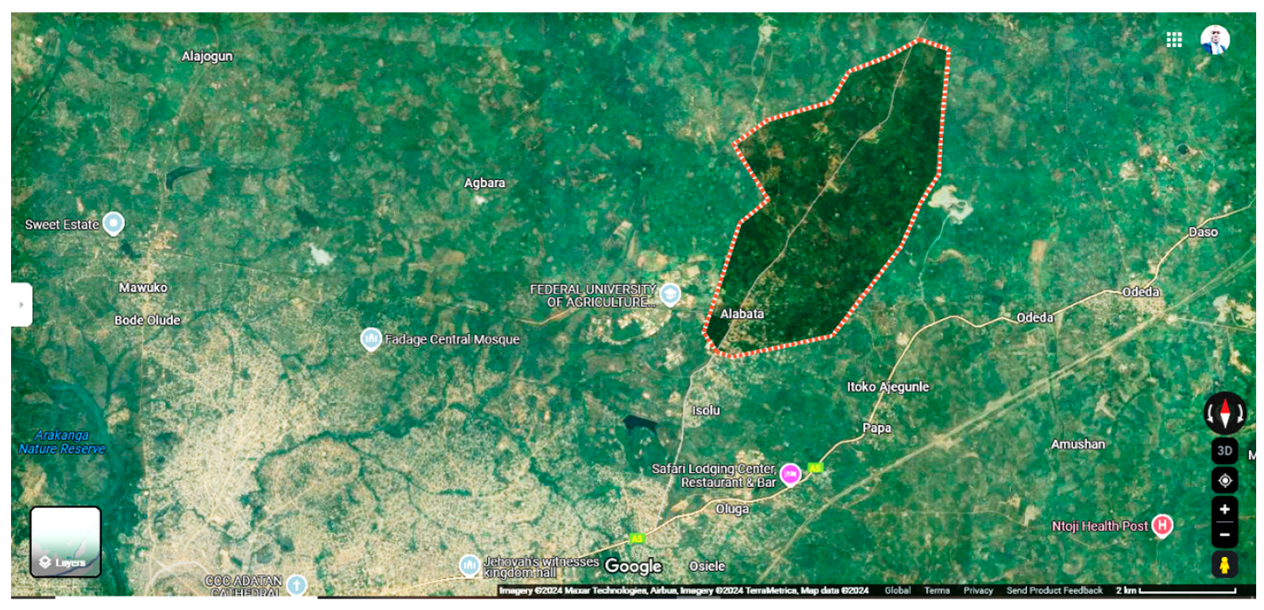
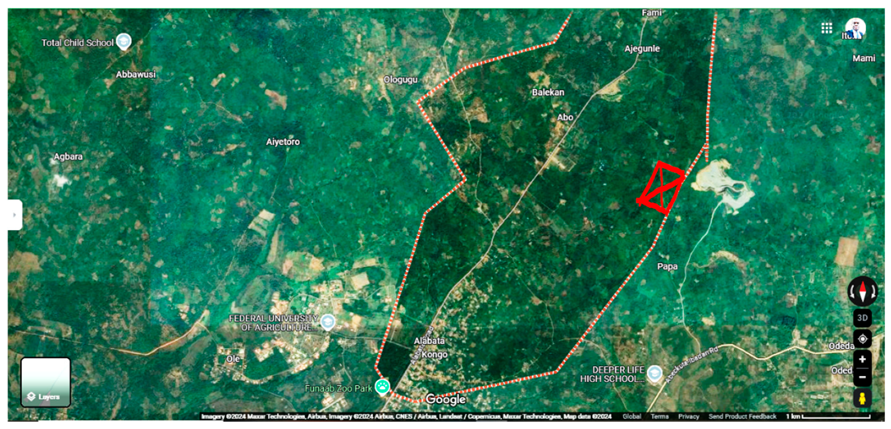
Figure 3.
Map showing the selected farm settlement within the Alabata village.
3.1. Study Area and Sampling Techniques
In this work, the rural settlements of Alabata are considered the subject of research. The level of sustainable development of the rural settlements and the influencing factors related to both the natural environment and socioeconomic levels are qualitatively analyzed using a local spatial correlations technique. A physical detector is utilized to figure out the weight of rural settlement sustainable expansion factors. A rural settlement sustainable development model is established. In terms of overall sustainability, the rural settlements in the Alabata farm settlement are poor demonstrating a medium to a low degree of sustainable development. The agricultural village has a clear spatial differential of ecologically sound development levels, with high-level communities mostly located in the vicinity of metropolitan regions.
Villages with poor equitable growth stages, ranging on the other hand, are dispersed. The degree of green growth has an opposite spatial linkage with slope and a beneficial regional correlation with the GDP, arable land, elevation, water systems, roads, normalized difference vegetation index (NDVI), and elevation. The amount of arable land and elevation have a greater impact on how sustainable rural communities are. The closely related habitation kinds are mostly grouped in dispersion, whereas the negatively correlated settlement types are scattered, per the results of the localized inquiry.
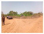
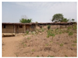
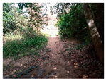
Following the selection of the farm settlement within the total sampled frame area of 1.50 km² (16,178,290.39 ft²) covering a total distance of 5.11 km (3.18 mi). The sample frame was divided into 6x6 with a total of 36 frames with similar ecological terrain and soil types which fell into either of the two identified soil types 1 and 2 (see Figure 4a). As highlighted in Figure 1, the study identified the various site conditions and classified them into five categories; existing topography, type of vegetation, existing land use, geological disaster sites, and soil erosion impact on the farm settlement.
Table 1 revealed that “existing topography and accessibility” to the farm settlement plays a significant role in harnessing the product from the farm however the access is accessible in the dry season of August-March but impassable during the rain downpours hence the “critical impact” rating. The “types of soil and vegetation; existing land use and land cover; soil erosion impact and dilapidation” all have an “extreme impact” on the terrain and they affect the farm settlement extremely. However, the geological conditions of the site have a lot of ecological benefits because of its natural state and a few threats to the farm products thereby it is rated as having either moderate or fair impacts on the farm by the onsite assessment of this study.
3.2. Data Collection
The study completed a questionnaire onsite using three major criteria and only 23 farmers responded positively to the few questions and they are represented in Table 2, Table 3 and Table 4. They were the farmers who were either living on the farm or working as hired laborers on-site at the time of the visit. They are mainly men (18) and only 5 women were seen working on the farm making a total of 23 respondents who were assessed. Some of the questions asked ranged from the years of experience as farmers and their level of productivity. Only three of them stand out and they are further summarized in this study; Question 1: What is your level of awareness on the impact of rainwater on the terrain and topographical erosion on the farm settlement? Question 2: What is your understanding of the deplorable state of the farm settlements? and Question 3: How has the impact of seasonal erosion and rainwater runoffs affected your farm product productivity and farmstead settlements?
The result checks over several cultivation seasons, in conjunction using productivity leveling techniques. Important land assessment characteristics, such as gradient, appropriate anchoring width and depth, surface roughness, texture, category, dampness constraints, and consistency, have been looked at to pinpoint agricultural yield determinants. Rural questionnaires, computerized topographical analyses, organic matter spectroscopic imaging, and farmland evaluation approaches were utilized to compile various characteristics to enhance output categorization. In light of such features, a couple of agriculture-related businesses within a rural community created several innovative methods that used artificial intelligence and another depending on the ecological assessment principles. The Ogun State farm settlements and the impact were mostly felt in the farmer settlements around the Ogun River channels and seasonal streams like Alabata village farm settlement.
3.3. Opinions, Perceptions, and Analysis of the Farmers' Response
Question 1: What is your level of awareness of the impact of rainwater on the terrain and topographical erosion on the farm settlement?
In this section of the survey, participants were asked to rank on a scale of 1 to 5 how aware they were of the effects of rainfall on the land, topographical erosion on farm settlements, and the likelihood of continuing the agribusiness. To prepare respondents for more inquiries, this inquiry sought to determine the extent of respondents' awareness of the hazards posed by erosion on the terrain. Table 2 highlighted the findings and showed that a resounding 34.78% of respondents had a very high degree of danger awareness. Notably, 21.74% showed a high and mild degree of awareness, demonstrating their ability to provide thoughtful assessments and understanding of the hazard.
Subsequent investigation showed that the extremely low percentage is around 8.69%, while the low percentage is approximately 13.04%. On the other hand, more than half were aware of the extent of the agricultural settlement's deterioration brought on by occasional weathering and periodic precipitation.
Ultimately, the application of this instrument helps the farmers and rural settlers assist in the sustenance of the farm settlement for sustainable farming activities. They can assist the land assessor to better classify the production potential of the land, as well as the decision-making authority to justify preserving more land for agricultural purposes.
Question 2: What is your understanding of the dilapidation state and abandonments of the farm settlements?
After determining that most of the participants were somewhat familiar with the farm settlement terrain, the next question asked if they were aware of its purpose and aims. The following is some of the feedback that was received from the 23 respondents who were mostly farm unskilled workers. Table 3 ranked 1st-5th positions in line with the responses and according to the firsthand experiences, impacts, and knowledge of the respondents from the lowest to the most extreme impacts.
Question 3: How has the impact of seasonal erosion and rainwater runoffs affected your farm product productivity and farmstead settlements?
The information collected from the rural dwellers and their experiences with terrain degradation in a farm settlement. Some of the responses given have been outlined and the remarks from on-site interviews with the farmers' inventories and assessment of the sites. It somewhat aligns with Table 1 in the ranking 4* (extreme impact), 3* (critical impact), 2* (moderate impact), 1* (fair impact), and 0 (no impact) but this time taken face-to-face feedback and comments considering their daily life experiences.
An overwhelming 65.21% of respondents have the most regrettable information about how the impact of erosion on the terrain has affected their farming activities (see Table 4). Notably, 17.39% expressed the critical impact of the natural occurrences on the farm how deplorable it has been, and how it has worsened in the past ten years. Only 4.35% of the respondents which is a small fraction of the farmers expressed their ignorance of the threats that erosion has caused the village in the past years. However, this set of people could be heard saying that they were new in the village and that they were not in the best position to give accurate reports of the events on the farm but only in the past year.
Figure 5, Figure 6 and Figure 7 show that the gentle slope could be allowing the sharp fall of rainwater runoff and it has a hazardous impact on the farm and the farmhouses are entirely vulnerable. Table 1 has identified some of these vulnerabilities are extremely high. Furthermore, the study's qualitative data reveals an inverse sentiment among certain respondents who, although acknowledging the natural occurrence and disintegration of the terrain, claimed never to have encountered it or known anything about it. These respondents will not be taken into consideration. This calls for a more thorough qualitative analysis of the effects of erosion and village spheres, indicating that characteristics such as exposure to individuals and knowledge emphasis may influence variability. The disparity between awareness and knowledge highlights the need for Ogun State and its neighboring states to promote more inclusive discussion to enable constructive conversations with educated opinions.
4. Results, Findings and Discussion
On the other hand, the geographical distribution characteristics of the agricultural production value density are not commensurate with the population density, among others. There are notable regional variations in how geographical variables influence the diversity of settlement features. Furthermore, the distribution of cultivated land and other natural biological features like elevation and landform have a significant impact on the spatial pattern of the studied region. The results of the study can help rural authorities and land and space planners create viable rural communities. The geographical layout of rural communities in Nigeria and throughout Sub-Saharan Africa has undergone substantial change as a result of the acceleration of urbanization and the execution of the rural regeneration plan. Rural rejuvenation cannot occur unless remote communities are suitable.
This study illustrates, examines, and assesses quantitatively and qualitatively whether building rural villages in mountainous regions is a suitable way to end poverty and hasten the pace of new urbanization. With geospatial gadgets like GPS and geo-detectors, the effects of local and natural environmental elements are identified. A suitability rating simulation was adopted using both ArcGIS 10.8 and Surfer 22 to calculate the surface area and volume of the ground surface degraded and exposed to harsh weather conditions due to both natural and man-made anthropogenic activities causing runoffs and continuous soil erosion. This was done to make the evaluation results more reasonable and scientific.
This has had an impact on agricultural output, forcing some farmers to move and leave their farms to resolve the arbitrary priority allocation issue and take into account the interactions between the affecting elements. The majority of rural settlement areas are found in river valleys and steep, low-lying higher elevations, with two descending zones of rather soft terrain separating them in the center. The neighboring livable regions are mostly home to the somewhat appropriate rural villages. This research might improve the methods for evaluating the viability of rural residential areas and serve as a guide for the development and rebuilding of rural agricultural habitation locales in mountainous locations. It is also applicable in various circumstances.
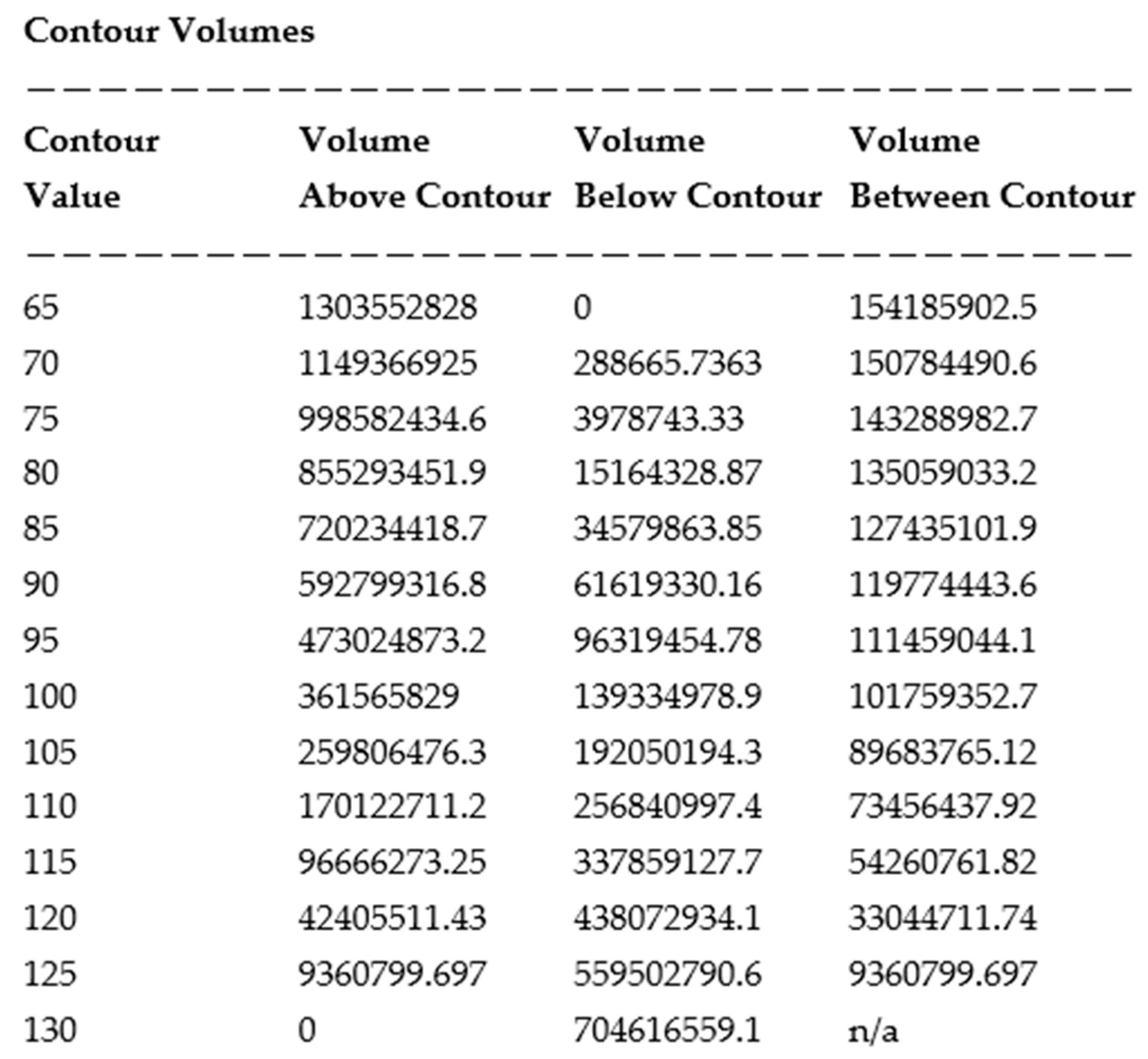
Grid Contour Volume and Area Report
The study used a grid input of a minimum contour of 65m with a maximum contour of 130m with a contour interval of 5m. The Grid Volume Computations are revealed in the table below. The upper surface uses 50 rows x 100 columns grid sizes with average reports as stated in Table 5 below (see Appendix A).
This study calculated the volume and surface area of the terrain contour value, surface area, surface above the contour, and surface area below the contour, which are the study indicators for rural resilience and settlements in the farmland ecological niche in Table 6. Due to their provision of living, working, and natural settings for rural inhabitants, rural communities have played an essential role in the development of the development of humanity. The geographical layout change of the countryside especially reflects a progressive optimization of their cohabitation with the socioeconomic system, natural environment, and other surrounding variables. The study's rural communities and the variations in the surrounding environment influenced the degree of mixed land use as well as the fundamental patterns of its spatial differentiation and deterioration, according to the findings. Significant influence elements comprised social and monetary, including the average family income and the number of residents. The amount of mixed land use was significantly impacted by agricultural tourism assets farm cluster laws, and several other reasons. Through onsite data collection and findings as represented in Table 7 (also see Appendix A for details), the rate of earth eroding, the amount of geophysical catastrophe concealed threat, and environmental factors are shown to be the primary factors determining the temporal susceptibility of villages in mountainous parts of Alabata. Increased average annual rainfall correlates with increased geographical vulnerability in rural communities, according to the statistical climatic component statistics, which is a percentage of yearly rainwater to inhabitants.

Table 6.
Study indicators for rural resilience and settlements in farmland ecological niche.
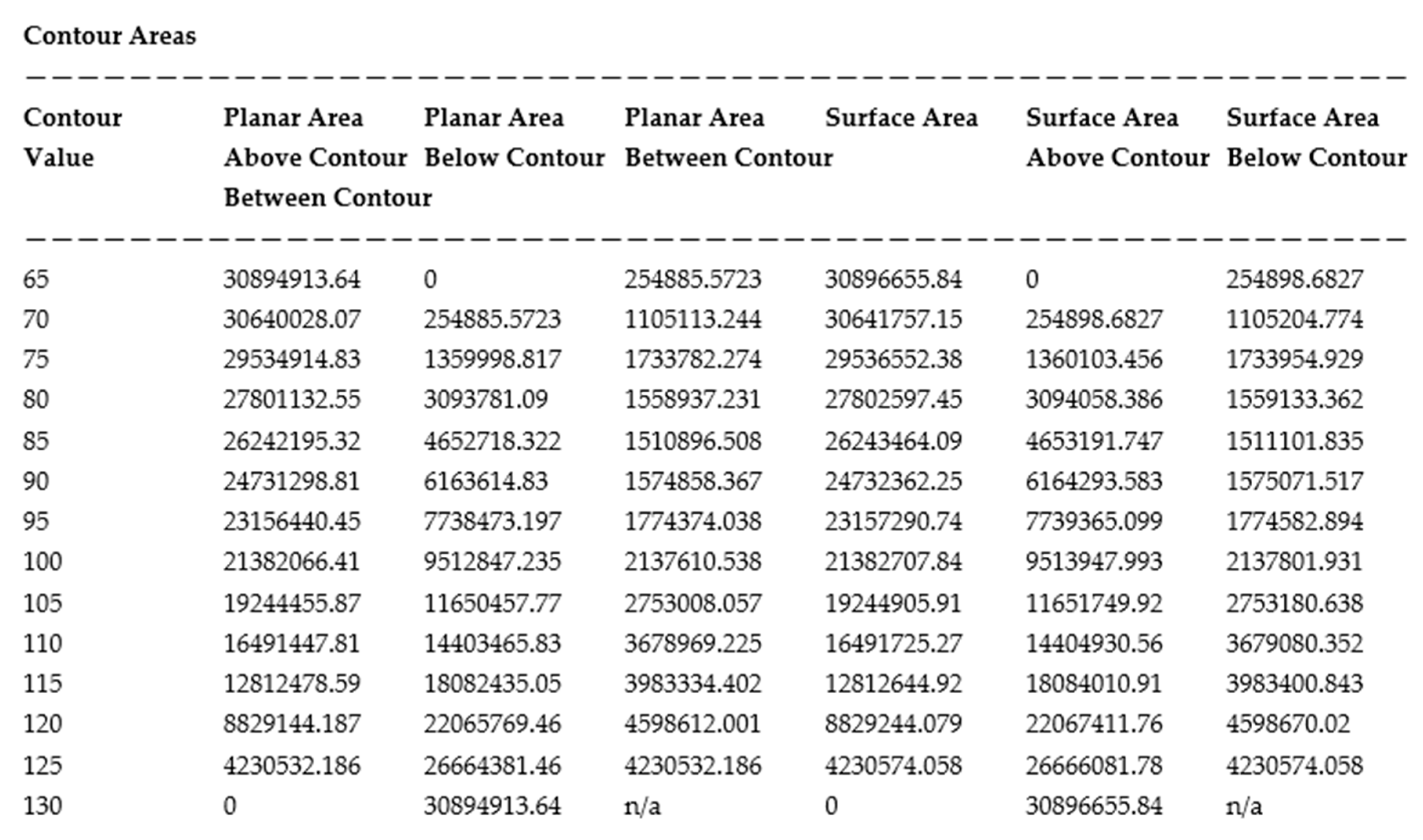
Table 7.
Study indicators for rural resilience and settlements in farmland ecological niche.
Earth erosion is the subsequent most significant impacting element; depending on what acute the amount of soil deterioration, greater geographic susceptibility in the regions and communities. Natural risks are an extra important contributing element; the deeper the likelihood of hazards associated with geology the greater the geographical susceptibility.
While demographic and socioeconomic factors exert essentially little effect on the geographical risk of agricultural villages, some environmental and physical characteristics related to land use seem to have some effect. Ultimately, the distributional features that determine the physical susceptibility of remote villages in the mountainous parts of Ogun State are outlined as villages become increasingly geographically vulnerable as nearby cities and regions are relative to the tectonic crack section.
Additionally, there is no variation across selected communities when it comes to the topographical susceptibility of agricultural communities in steep terrain; it is more prevalent in some parts than others. The research then suggests methods and ideas to lessen the overall exposure of farming neighborhoods, on the previously mentioned results. It also provides neighborhood planning agencies with data assistance and sources of information for their efforts in remote farm settlements.
5. Conclusions
The assessment created an approach for evaluating the geographical fragility and susceptibility of villages in the rolling hills of Ogun State by gathering information on ecological geographic parameters, the physical form, and social and economic factors of these villages. According to the studies, eroded land, possible geophysical catastrophes, and ecology are the primary elements influencing the geographical vulnerabilities of villages. Simultaneously, we can infer from the magnitude of the consequences measure that the geographical information associated with rural villages (such as the surrounding area disintegration and the geometry perimeter ranking of farmland impacts the geographical exposure of those villages to some extent, albeit not the same extent as the effects of weather, damage to the soil, possible disasters, and surfaces slope. Analyzing the agricultural landscape patterns in mountainous areas is critical to clarify the dynamic changes and development direction of agricultural landscapes. This also plays a significant role in the rational planning and management of agricultural land. The study provides an important means of promoting the intensive and efficient use of land resources and stimulating endogenous development power in rural areas.
Ultimately, the geographical spread pattern of the geospatial susceptibility, fragility, and exposure of agricultural settlements in hilly regions was discovered by merging the location-based knowledge with the geographical fragility details of this investigation. Severe location-based exposure farms tend to be close to the Abeokuta township. Simultaneously, the spatially vulnerable rural settlement district and county distributions frequently align with the approximate site of a possible natural disaster. Given that the Alabata communities are situated in the highlands and the arrangement is relatively constant, the distance compromise of the less developed areas along the Ogun River.
The amount of all variables influencing the susceptibility of Alabata's hilly regions, which in turn contribute to the key variables influencing the overall susceptibility of farmland villages, are the severity of eroded soil, the possibility of geologic risks, and the environmental conditions. The risk of natural catastrophic occurrences occurring is significantly influenced by rainfall in climatic conditions. A short period of rainfall will result in an abrupt rise in aquifers, improve the total mass of the earth and its minerals layer, and decrease the contact that occurs between rock and dirt fragments. These factors will increase the likelihood of flooding and erosion, and these will negatively impact the rural region's geographical exposure and damage the area around villages.
The amount of soil breakdown increases the separation across fragments in the rock-based soil layer, and these decrease the rock debris layer's physical features and enhance unsteadiness. This increases the likelihood of natural disasters in rural settlements and increases their spatial vulnerability. In the past, there have been significant catastrophes geologically in the region due to the presence of concealed geological dangers in rural settlements. This region has all the prerequisites for geological disasters in terms of unforeseen circumstances, and as the likelihood of geophysical hazards in coming years increases, it also increases agricultural spatiotemporal fragility.
One of the main worries of ecological and landscape catastrophes as identified in this study is the seasonal irregularity and periodic happenings of the disasters. Following the tremors several subsequent natural events might occur as a result of the outermost and slopes being destroyed. The enormous volume of the run of topsoil created for instance; surface cracks that could result in disintegration and mudslides the blocked pond created by the slippage of soil that blocked the river could trigger catastrophes both upward and downward slopes; unpredictable fractured terrain and flooding build-up might disintegrate alongside fall another time. To sum up, the data collected demonstrates that promoting heterogeneous adaptive land use is a crucial strategy for enhancing village revival. Soon hybrid land use might be included in village management agricultural land use productivity, modify site usage design to local conditions, and foster seamless growth of all sorts of agribusinesses in agricultural regions. Furthermore, to increase the effectiveness with which agricultural and publicly owned assets exist adopted, guided, by rational thought and inquiry, to form suitable agglomerations.
Author Contributions
A. A. J. prepared the introduction, literature review, conceptualization, methodology resources, data curation, visualization, and writing of the manuscript. A. A. J. writing—original draft preparation analyzed the collected data, prepared the maps, investigation, software, formal analysis, and analyzed all geospatial information. T. X. and Y. R. supervision, writing—review and editing, validation, reviewed, and revised the manuscript to this present form. T. X. provided funding acquisition. W. N. F. project administration. A. A. J., T. X., Y. R., and W. N. F. have read and agreed to the submitted version of the manuscript. All authors contributed to critically fine-tuning the paper. All authors have read and agreed to the published version of the manuscript.
Funding
The APC was funded by T. X.
Data Availability Statement
The data that support the findings of this study are available upon reasonable request.
Acknowledgments
The authors acknowledge the editorial team for review of this article.
Conflicts of Interest
The authors declare no conflicts of interest.
Appendix A
See Appendix A for the grid contour, volume, and area report of Alabata farm settlement: https://docs.google.com/document/d/1CbEe8Vl444DRPPARdmJww44hbTW_0BK7/edit?usp=drive_link&ouid=100070962692448032922&rtpof=true&sd=true.
References
- Huang, M., Li, Y., Ran, C., & Li, M. (2022). Dynamic changes and transitions of agricultural landscape patterns in mountainous areas: A case study from the hinterland of the Three Gorges Reservoir Area. Journal of Geographical Sciences, 32(6), 1039-1058. [CrossRef]
- Chen, S., Mehmood, M. S., Liu, S., & Gao, Y. (2022). Spatial pattern and influencing factors of rural settlements in Qinba Mountains, Shaanxi Province, China. Sustainability, 14(16), 10095. [CrossRef]
- Qin, Y., Luo, G., Li, Y., Tan, Q., Zheng, C., Yu, M., ... & Li, M. (2022). Assessment of sustainable development of rural settlements in mountainous areas: a case study of the Miaoling Mountains in southwestern China. Land, 11(10), 1666. [CrossRef]
- Barichievy, K. R. (2022). Evaluating soil and terrain variables in a production environment: implications for agricultural land assessment (Doctoral dissertation, Stellenbosch: Stellenbosch University). https://scholar.sun.ac.za/items/07c9db8e-330f-40a5-9d9a-e230005906e3.
- Liu, Y., Shu, B., Chen, Y., & Zhang, H. (2023). Spatial vulnerability assessment of rural settlements in hilly areas using BP neural network algorithm. Ecological Indicators, 157, 111278. [CrossRef]
- Yang, Z., Yang, D., Geng, J., & Tian, F. (2022). Evaluation of suitability and spatial distribution of rural settlements in the Karst Mountainous Area of China. Land, 11(11), 2101. [CrossRef]
- Xu, J., Zheng, L., Ma, R., & Tian, H. (2023). Correlation between distribution of rural settlements and topography in Plateau-Mountain area: a study of Yunnan Province, China. Sustainability, 15(4), 3458. [CrossRef]
- Liu, Y., Ke, X., Wu, W., Zhang, M., Fu, X., Li, J., ... & Zhou, X. (2022). Geospatial characterization of rural settlements and potential targets for revitalization by geoinformation technology. Scientific reports, 12(1), 8399. [CrossRef]
- Zhou, H., Na, X., Li, L., Ning, X., Bai, Y., Wu, X., & Zang, S. (2023). Suitability evaluation of the rural settlements in a farming-pastoral ecotone area based on machine learning maximum entropy. Ecological Indicators, 154, 110794. [CrossRef]
- Chen, H., Su, K., Peng, L., Bi, G., Zhou, L., & Yang, Q. (2022). Mixed land use levels in rural settlements and their influencing factors: A case study of Pingba Village in Chongqing, China. International Journal of Environmental Research and Public Health, 19(10), 5845. [CrossRef]
- Shi, Z., Ma, L., Zhang, W., & Gong, M. (2022). Differentiation and correlation of spatial pattern and multifunction in rural settlements considering topographic gradients: Evidence from Loess Hilly Region, China. Journal of Environmental Management, 315, 115127. [CrossRef]
- Wang, Y., Cheng, L., & Zheng, Y. (2022). Rural Effectiveness Evaluation: A New Way of Assessing Village Development Status. Sustainability, 14(15), 9059. [CrossRef]
- Yu, M., Li, Y., Luo, G., Yu, L., & Chen, M. (2022). Agroecosystem composition and landscape ecological risk evolution of rice terraces in the southern mountains, China. Ecological Indicators, 145, 109625. [CrossRef]
- Erdem Kaya, M., Kaya, H. S., Terzi, F., Tolunay, D., Alkay, E., Bektaş Balçik, F., ... & Serdar Yakut, S. E. (2024). The landscape identity of rural settlements: Turkey’s Aegean Region. Urbani Izziv, 35(1). [CrossRef]
- Chen, S., Wang, X., Qiang, Y., & Lin, Q. (2024). Spatial-temporal evolution and land use transition of rural settlements in mountainous counties. Environmental Sciences Europe, 36(1), 38. [CrossRef]
- Tu, R., Wan, A., Chen, H., Liu, Y., & Qi, X. (2024). Rural landscape comprehensive evaluation system and case study based on environmental value-added. Environment, Development and Sustainability, 1-20. [CrossRef]
- Yang, E., Yao, Q., Long, B., An, N., & Liu, Y. (2024). Progress in the Research of Features and Characteristics of Mountainous Rural Settlements: Distribution, Issues, and Trends. Sustainability, 16(11), 4410. [CrossRef]
- Long, T., Ișık, C., Yan, J., & Zhong, Q. (2024). Promoting the sustainable development of traditional villages: exploring the comprehensive assessment, spatial and temporal evolution, and internal and external impacts of traditional village human settlements in Hunan province. Heliyon. [CrossRef]
- Zhou, Y., Liu, M., Xie, G., & Liu, C. (2024). Landscape ecology analysis of traditional villages: A case study of Ganjiang River Basin. Applied Sciences, 14(2), 929. [CrossRef]
- Zou, Y., Rao, Y., Luo, F., Yi, C., Du, P., Liu, H., ... & Zhou, Y. (2024). Evolution of rural settlements and its influencing mechanism in the farming-pastoral ecotone of Inner Mongolia from a production-living-ecology perspective. Habitat International, 151, 103137. [CrossRef]
- İzgi, B. D. (2024). Layering Analysis of Typomorphology Dynamics in Rural Settlements Using the AHP Method. ICONARP International Journal of Architecture and Planning, 12(1), 162-188. [CrossRef]
- Zhang, X., Li, J., & Xu, J. (2024). Micro-Scale Analysis and Optimization of Rural Settlement Spatial Patterns: A Case Study of Huanglong Town, Dayu County. Land, 13(7), 966. [CrossRef]
- Chen, S., Wang, X., & Lin, Q. (2024). Spatial pattern characteristics and influencing factors of mountainous rural settlements in metropolitan fringe area: A case study of Pingnan County, Fujian Province. Heliyon, 10(4). [CrossRef]
- Aliyu, M. A., Maharazu, A. Y., Suleiman, K., & Lawan, B. Y. (2021). Biophysical Mapping and Land Use Attributes of Kano Ecosystems, North-western Nigeria. Bayero Journal of Pure and Applied Sciences, 14(2), 115-124. [CrossRef]
- Adeyemi, A. A., & Ayinde, M. O. (2022). Evaluation of Land-Use and Land-Cover Changes in Oba Hills Forest Reserve, Osun State, Nigeria. Forestist, 72(2). [CrossRef]
- Isaac, O. O. O., Olufemi, A. B., Emmanuel, D., Adekunle, S. A., Nene, E. O. A., & Isioma, N. J. (2021). Dynamism of Landscape Transformation in Ibiono-Ibom, Akwa-Ibom State, Nigeria. Journal of Landscape Ecology, 14(1), 19-38. https://sciendo.com/article/10.2478/jlecol-2021-0002.
- Seun, A. I., Ayodele, A. P., Koji, D., & Akande, S. O. (2022). The potential impact of increased urbanization on land surface temperature over South-West Nigeria. Current Research in Environmental Sustainability, 4, 100142.
- Odoh, B. I., Nwokeabia, C. N., & Ezealaji, P. I. (2024). Integrated geological and geomorphological analysis for sustainable land use planning in the Abia Region of southeastern Nigeria. International Journal of Science and Research Archive, 12(2), 1526-1538. [CrossRef]
- Ishaku, A. R., Isah, A., Isa, M. S., Abdullahi, I., Umar, A. A., Mohammed, B. B., ... & Abba, U. J. (2021). GIS and remote sensing analysis of the impact of land use land cover change on forest degradation: Evidence from the Central Part of Taraba State, Nigeria. Journal of Geography, Environment and Earth Science International, 25(11), 27-39. [CrossRef]
- Fasona, M. J., Akintuyi, A. O., Adeonipekun, P. A., Akoso, T. M., Udofia, S. K., Agboola, O. O., ... & Ogundipe, O. T. (2022). Recent trends in land use and cover change and deforestation in southwest Nigeria. GeoJournal, 87(3), 1411-1437. [CrossRef]
- Ojeh, V. N., Yusha'u, A. M., & Usman, D. S. (2022). Assessment of changes in land cover by deforestation in Kurmi LGA, Taraba State, Nigeria using remote sensing/geographic information system. Aswan University Journal of Environmental Studies, 3(1), 67-87. [CrossRef]
- Ojo, A. O., Ojo, M. A., Ajani, Y. O., Oseghale, A. I., & Busari, A. O. (2022). Assessment of Effects of Land Degradation on Productivity of Arable Crop Farmers in Selected Local Government Areas of Ogun State, Nigeria. http://repository.rjt.ac.lk/handle/123456789/4820.
- Zehang, W. E. I., Jianwei, S. U. N., Liu, Y. A. N. G., Jing, L. U. O., & Qiuyu, Z. (2024). Vulnerability and influencing factors for rural settlements land use in karst mountains of China: A case study on Qixingguan District. Journal of Resources and Ecology, 15(3), 720-732. [CrossRef]
- Zhou, L., Zhao, Y., Yang, X., He, J., & Wang, H. (2023). Identification of important terraced visual landscapes based on a sensitivity-subjectivity preference matrix for agricultural cultural heritage in southwestern China. Ecological Indicators, 154, 110573. [CrossRef]
- Adesina, J. A., & Zhu, J. (2022). Synoptic review of forestry and forest products trade and production in Africa. Mercator (Fortaleza), 21, e21005. [CrossRef]
- Yang, Q., Gao, Y., Cao, X., & Yang, J. (2023). Contributions and resistance to the vulnerability of rural human settlements system in agricultural areas of the Chinese loess plateau since 1980. Sustainability, 15(14), 10948. [CrossRef]
- Lou, R., & Wang, D. (2024). Rural Settlement Optimization for Ecologically Sensitive Area Evaluations Based on Geo-Proximity and the Soil–Water Conservation Capacity. Land, 13(7), 1071. [CrossRef]
- Ying, B., Li, S., Xiong, K., Hou, Y., Liu, T., & Sun, R. (2023). Research on the resilience assessment of rural landscapes in the context of karst rocky desertification control: A case study of Fanhua village in Guizhou province. Forests, 14(4), 733. [CrossRef]
- Duan, Y., Chen, S., Zhang, L., Wang, D., Liu, D., & Hou, Q. (2023). Spatial Distribution Characteristic and Type Classification of Rural Settlements: A Case Study of Weibei Plain, China. Sustainability, 15(11), 8736. [CrossRef]
- Karkee, K., Gurung, S., & Joshi, A. (2023). Assessing Terrain Hazards for Sustainable Human Settlements in Chāngunārāyan Municipality of Kathmandu Valley, Nepal. In Nature, Society, and Marginality: Case Studies from Nepal, Southeast Asia and other regions (pp. 85-99). Cham: Springer International Publishing. [CrossRef]
- Faye, B., Du, G., Li, Q., Faye, H. V. M. T., Diéne, J. C., Mbaye, E., & Seck, H. M. (2024). Lessons learned from the influencing factors of forested areas’ vulnerability under climatic change and human pressure in arid areas: a case study of the Thiès Region, Senegal. Applied Sciences, 14(6), 2427. [CrossRef]
- Zhu, S., Sun, J., Wu, Y., Lu, Q., Ke, Y., Xue, Z., ... & Xiao, Y. (2024). Vertical Spatial Differentiation and Influencing Factors of Rural Livelihood Resilience: Evidence from the Mountainous Areas of Southwest China. Agriculture, 14(8), 1295. [CrossRef]
- Chen, X., Rong, F., & Li, S. (2024). Driving force–pressure–state–impact–response-based evaluation of rural human settlements’ resilience and their influencing factors: Evidence from Guangdong, China. Sustainability, 16(2), 813. [CrossRef]
- Masruroh, H., Irawan, L. Y., & Anam, C. (2024). Comprehensive spatial analysis landslide susceptibility modeling, spatial cluster analysis, and priority zoning for environment analysis. International Journal of Environmental Science and Technology, 1-22. [CrossRef]
- Alam, M., Khan, M. Z., Begum, F., & Baig, T. R. (2024). Assessing the climate vulnerability of mountain agriculture: a case study of Haramosh Valley in Central Karakoram, Pakistan. Environment, Development and Sustainability, 1-29. [CrossRef]
- Asempah, M., Shisanya, C. A., & Schütt, B. (2024). Modeling of soil erosion risk in a typical tropical savannah landscape. Scientific African, 23, e02042. [CrossRef]
- Mateso, J. C. M., Dewitte, O., & Bielders, C. L. (2024). Living with landslides: Land use on unstable hillslopes in a rural tropical mountainous environment in DR Congo. Science of The Total Environment, 925, 171624. [CrossRef]
- Omanga, A. M., Sichangi, A. W., Makokha, G. O., & Waswa, R. N. (2024). Assessing the effect of change in climate and land use on groundwater recharge suitability in the Thiba River Sub Basin, Kenya. [CrossRef]
- Mwalwimba, K. I., Manda, M., & Ngongondo, C. (2024). Towards a Framework for Flood Vulnerability Assessment for Rural and Urban Informal Settlements in Malawi. J Geogr Nat Disasters, 14, 305. https://www.researchgate.net/profile/Cosmo-Ngongondo/publication/382428380_.
- Berhanu, A. A., Ayele, Z. B., Dagnew, D. C., Melese, T., Fenta, A. B., & Kassie, K. E. (2024). Smallholder farmers' vulnerability to climate change and variability: Evidence from three agroecologies in the Upper Blue Nile, Ethiopia. Heliyon, 10(7). [CrossRef]
- Singh, R. G. (2024). A multi-scale study of wind erosion susceptibility along the South African Wild Coast. Dissertation presented in fulfillment of the requirements for the degree of Doctor of Philosophy in the Faculty of Science at Stellenbosch University. https://scholar.sun.ac.za/server/api/core/bitstreams/eb55c9f8-24a7-483d-b449-836f36f18a6e/content.
- Alaoui, K. A., Radoine, H., & Nahiduzzaman, K. M. (2024). Rural planning evaluation and sustainable development potential in rural communes of Rehamna province (Morocco). Journal of Urban Management. [CrossRef]
- Metegam, I. F. F., Bomeni, I. Y., Chara-Dackou, V. S., Njomo, D., & Tchinda, R. (2024). Assessment of the Geographic and Technical Potential for Large-Scale Wind Energy Production Using a GIS-Based MCDM-AHP Multi-criteria Analysis Method and Sensitivity Analysis: Case of Cameroon. [CrossRef]
- Yessoufou, A. N. D., Kumar, S., Houessionon, P., Worou, O. N., Wane, A., & Whitbread, A. (2024). Vulnerability and resilience in the face of climate changes in Senegal's drylands: measurement at the household level and determinant assessment. Frontiers in Climate, 6, 1330025. [CrossRef]
- Xie, H.; Sun, Q.; Song, W. Exploring the Ecological Effects of Rural Land Use Changes: A Bibliometric Overview. Land 2024, 13, 303. [Google Scholar] [CrossRef]
- Zou, Y.; Yi, C.; Rao, Y.; Luo, F.; Lv, C.; Wu, P. Identify Optimization Type of Rural Settlements Based on “Production–Living–Ecological” Functions and Vitality: A Case Study of a Town in Northern China. Land 2023, 12, 1905. [Google Scholar] [CrossRef]
- Di Fazio, S.; Modica, G. Historic Rural Landscapes: Sustainable Planning Strategies and Action Criteria. The Italian Experience in the Global and European Context. Sustainability 2018, 10, 3834. [Google Scholar] [CrossRef]
- Balgah, R.A.; Ngwa, K.A.; Buchenrieder, G.R.; Kimengsi, J.N. Impacts of Floods on Agriculture-Dependent Livelihoods in Sub-Saharan Africa: An Assessment from Multiple Geo-Ecological Zones. Land 2023, 12, 334. [Google Scholar] [CrossRef]
- Gatwaza, O. C., & Wang, X. (2023). Predicting the future of protected areas in the region of the highest population density in sub-Saharan Africa. Journal of Sustainable Forestry, 42(1), 22-42. [CrossRef]
- Dube, T., Dube, T., & Marambanyika, T. (2023). A review of wetland vulnerability assessment and monitoring in semi-arid environments of sub-Saharan Africa. Physics and Chemistry of the Earth, Parts A/B/C, 103473. [CrossRef]
- Birhanu, B. Z., Sanogo, K., Traore, S. S., Thai, M., & Kizito, F. (2023). Solar-based irrigation systems as a game changer to improve agricultural practices in sub-Sahara Africa: A case study from Mali. Frontiers in Sustainable Food Systems, 7, 1085335. [CrossRef]
- Tang, X.; Adesina, J.A. Integrated Watershed Management Framework and Groundwater Resources in Africa—A Review of West Africa Sub-Region. Water 2022, 14, 288. [Google Scholar] [CrossRef]
- Tang, X.; Adesina, J.A. Biodiversity Conservation of National Parks and Nature-Protected Areas in West Africa: The Case of Kainji National Park, Nigeria. Sustainability 2022, 14, 7322. [Google Scholar] [CrossRef]
- Mshelia, Z. H., Nyam, Y. S., Moisès, D. J., & Belle, J. A. (2024). Geospatial analysis of flood risk hazard in Zambezi Region, Namibia. Environmental Challenges, 15, 100915. [CrossRef]
- Okonkwo, Chris C., Emmanuel C. Chukwuma, Louis C. Orakwe, and Gloria C. Okafor. "Geospatial-based analysis for soil erosion susceptibility evaluation: application of a hybrid decision model." Modeling Earth Systems and Environment 9, no. 1 (2023): 987-1007. [CrossRef]
- Munyaka, J.-C.B.; Chenal, J.; Mabaso, S.; Tfwala, S.S.; Mandal, A.K. Geospatial Tools and Remote Sensing Strategies for Timely Humanitarian Response: A Case Study on Drought Monitoring in Eswatini. Sustainability 2024, 16, 409. [Google Scholar] [CrossRef]
- Sarfo, I., Qiao, J., Yeboah, E., Puplampu, D. A., Kwang, C., Fynn, I. E. M., ... & Sarfo, B. A. (2024). Meta-analysis of land use systems development in Africa: Trajectories, implications, adaptive capacity, and future dynamics. Land Use Policy, 144, 107261. [CrossRef]
- Munyaka, J.-C.B.; Chenal, J.; de Roulet, P.T.H.; Mandal, A.K.; Pudasaini, U.; Otieno, N.O. Multi-Level Participatory GIS Framework to Assess Mobility Needs and Transport Barriers in Rural Areas: A Case Study of Rural Mumias East, a Sub-County of Kakamega, Kenya. Sustainability 2023, 15, 9344. [Google Scholar] [CrossRef]
Disclaimer/Publisher’s Note: The statements, opinions, and data contained in all publications are solely those of the individual author(s) and contributor(s) and not of MDPI and/or the editor(s). MDPI and/or the editor(s) disclaim responsibility for any injury to people or property resulting from any ideas, methods, instructions, or products referred to in the content. |
Figure 1.
Study indicators for rural resilience and settlements in farmland ecological niche.
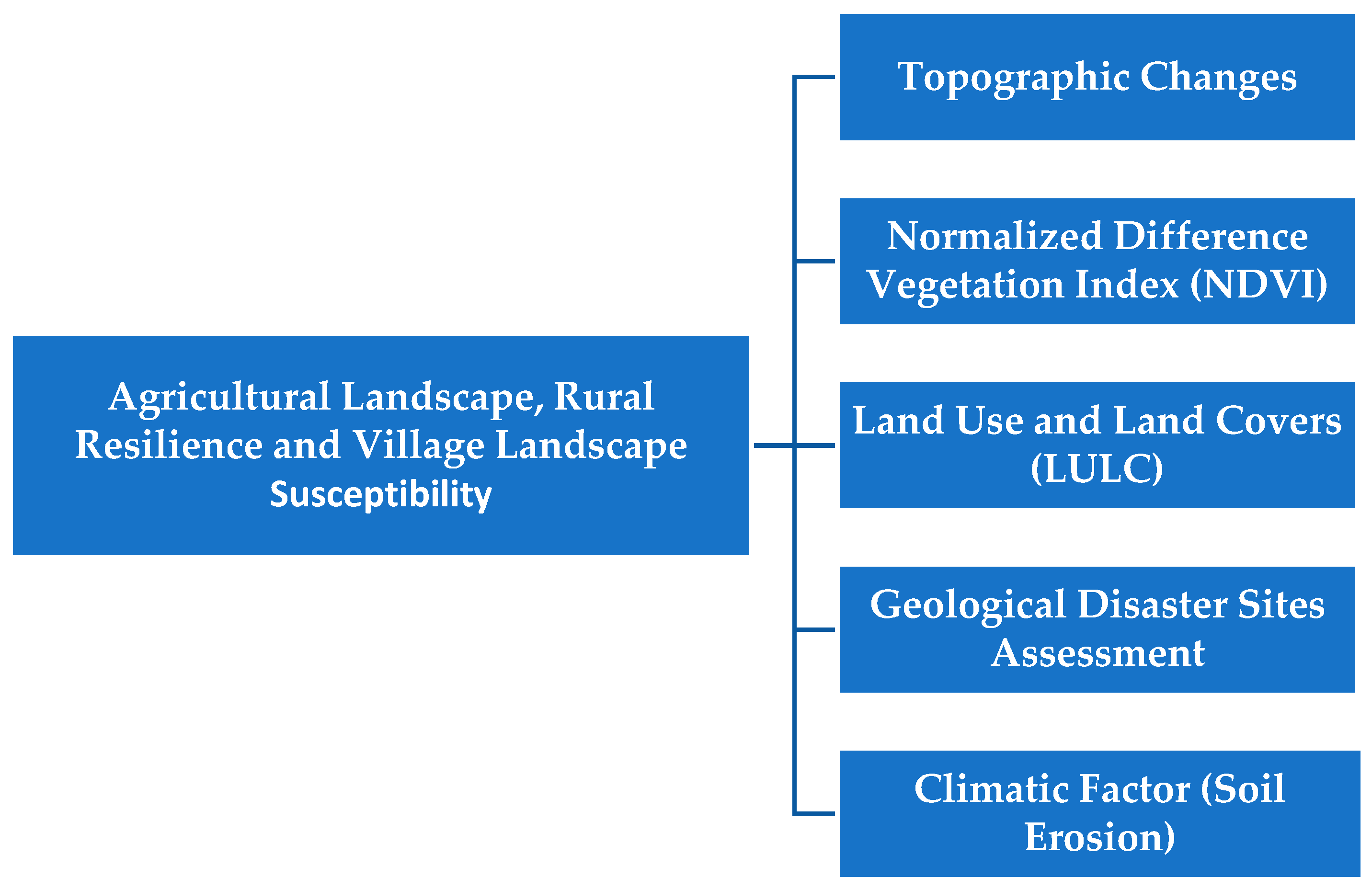
Figure 4.
a. The selected farm settlement is divided into different sample frames and two different soil types (1&2); b. The selected farm settlement shows the perimeter boundary of the adjourning seasonal streams and the Ogun River.
Figure 4.
a. The selected farm settlement is divided into different sample frames and two different soil types (1&2); b. The selected farm settlement shows the perimeter boundary of the adjourning seasonal streams and the Ogun River.
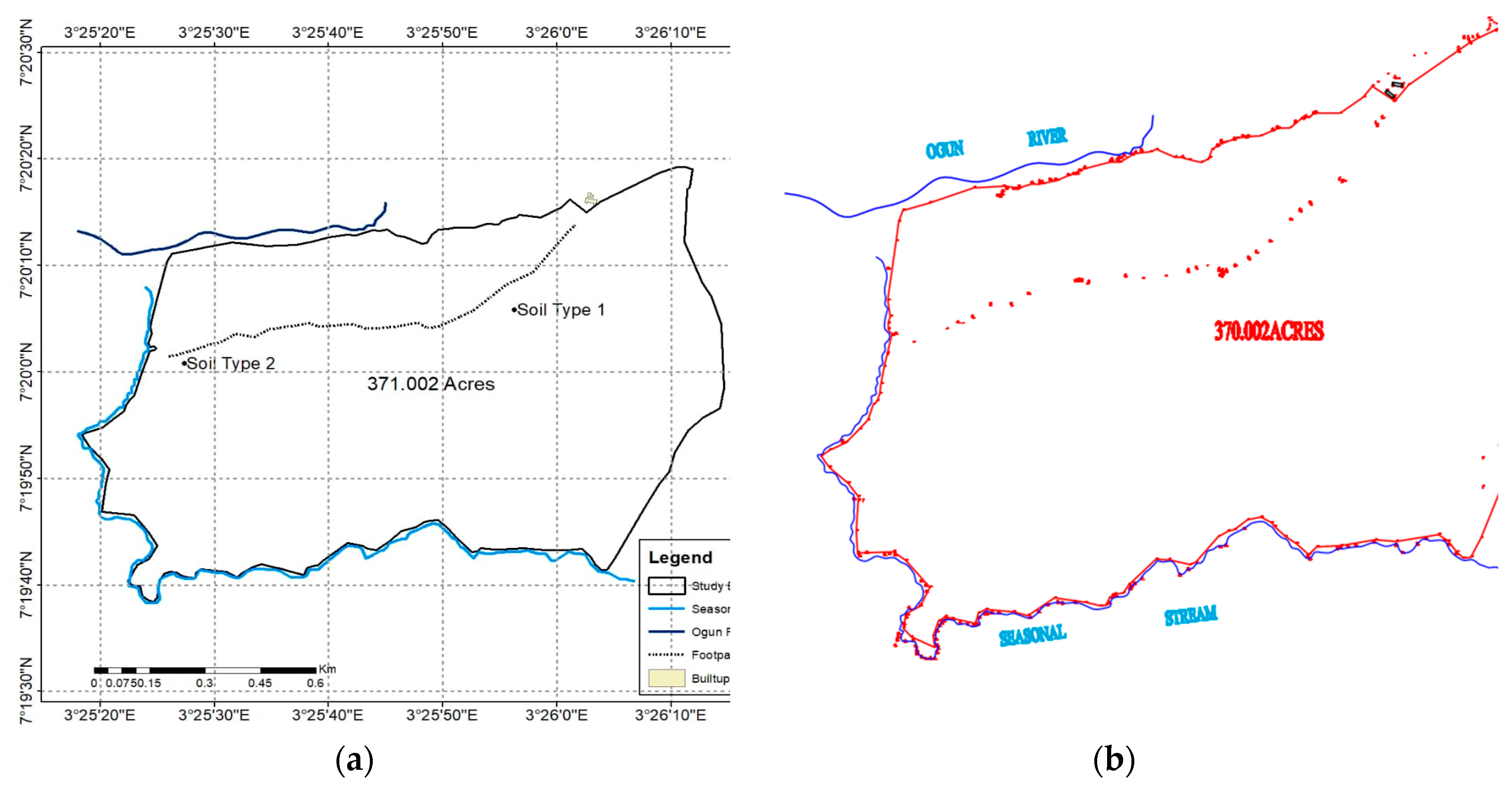
Figure 5.
a&b. The 2D & 3D Digital Elevation Model (DEM) of the land shows the existing landform.
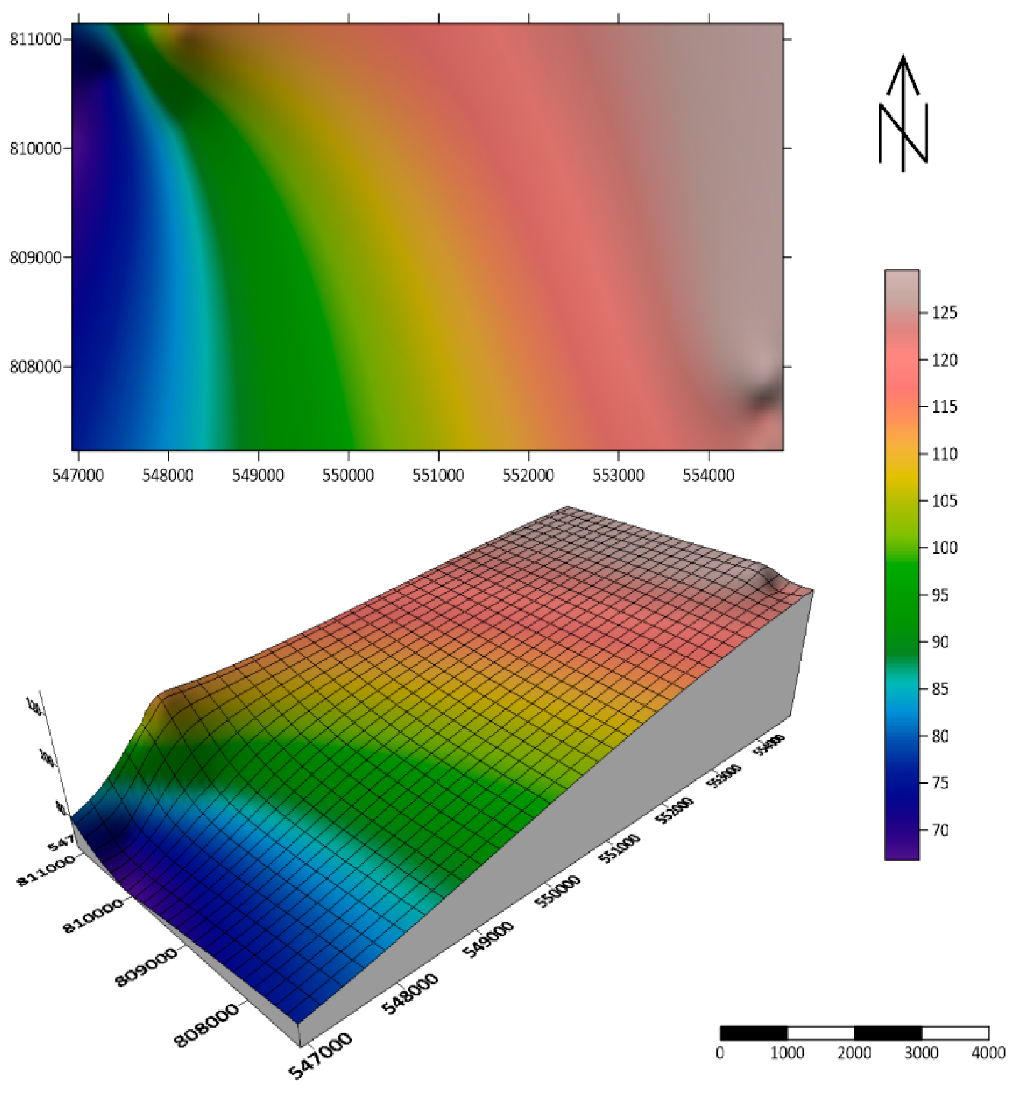
Figure 6.
a. Terrain slope and contour of the terrain. b. The grid info report and spot heights of the terrain.
Figure 6.
a. Terrain slope and contour of the terrain. b. The grid info report and spot heights of the terrain.
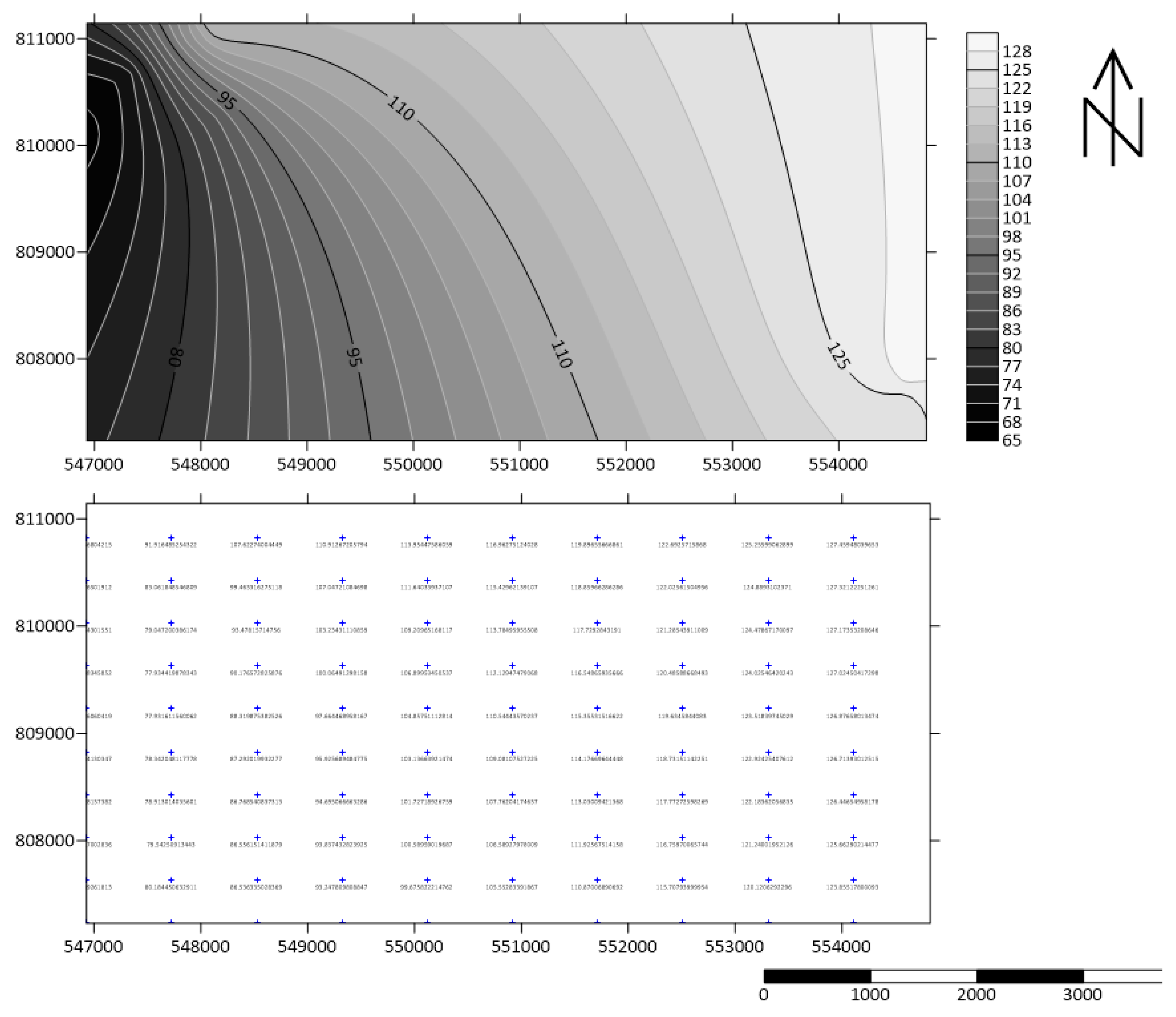
Figure 7.
Drainage and hydrology map showing the direction of rainwater.
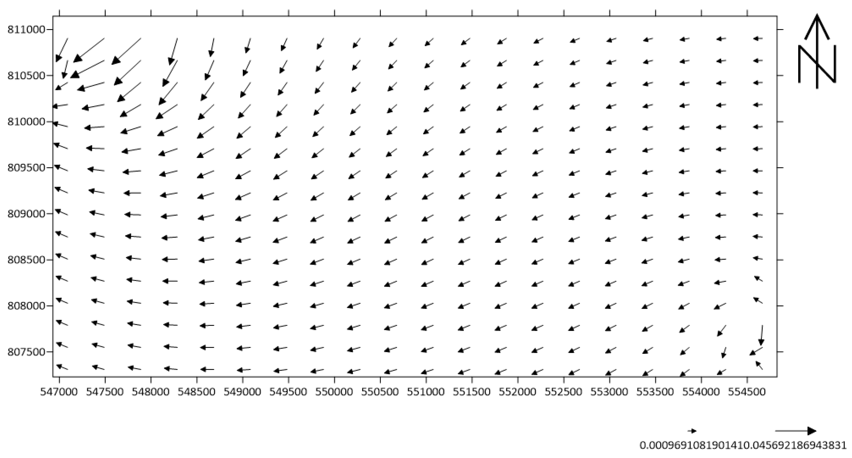
Table 1.
Table showing the impact of rainwater and terrain slope on the existing site conditions and assessment of the farm settlement.
Table 1.
Table showing the impact of rainwater and terrain slope on the existing site conditions and assessment of the farm settlement.
| Existing Topography and Accessibility | ||
|---|---|---|
 |
The farm settlement is accessible and the roads are untarred and inaccessible when it rains. The signposts are conspicuously visible for prompt accessibility. | ** |
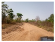 |
The connecting road through the community to the farm site is under study. Muddy and slippery roads are inaccessible when it rains. | *** |
 |
The node where three roads are lined is still untarred and inaccessible after a few downpours. | *** |
| Types of Soil and Vegetation | ||
 |
Surface roughness, texture, category, dampness constraints, and consistency, Type 1 | **** |
 |
Surface roughness, texture, dampness constraints and consistency, soil type 1 | **** |
 |
Surface roughness, texture, dampness constraints, and consistency, muddy toward the lower region. It is soil type 2 | **** |
| Existing Land Use and Land Cover | ||
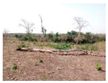 |
In November-December, 2023 during the site visit. With the low volume of rainfall during this period. Some trees could be seen already fallen. | **** |
 |
Soil condition to be seen without vegetation as farmers are preparing for the next planting season of January 2024 | **** |
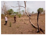 |
A few farmers could be seen preparing the site by cutting down more trees and channeling the terrain to divert the direction of rainwater and runoff. | **** |
| Geological Conditions of the Site | ||
 |
Rocky area around the Ogun River. The area is not suitable for farming activities but a safe zone for farmers who want to relax after a long day of work. | ** |
 |
Turbid water and sediments due to limited rainfall during the site visit, usually the rocky pieces are always submerged in the river but they are now visible because of the low water level. | ** |
 |
The tree could be seen between the buffer of the river and the farm. There are a lot of monkeys and birds hopping around the cool ecological zone. | * |
 |
A narrow pathway that connects the Ogun River. The river cascades into the footpaths whenever the water table goes up. It makes the water a threat to the farm due to the influx of wild reptiles (snakes). | ** |
| Soil Erosion Impact and Dilapidation | ||
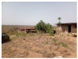
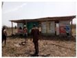
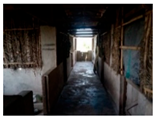 |
The continuous dilapidation of the piggery has caused the death of a lot of pigs in recent times due to disease attacking the swine. it has also led to non-usage and abandonment. | **** |
 |
The ceiling and part of the walls of the poultry and fishery are pull-out and the farmhouse is no longer conducive for the chicks, chicken, hens, and fish. | **** |
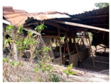 |
Open storehouse where harvested products are kept before being transported to the city. No longer habitable due to abandonment and erosion has washed off part of the foundation. | **** |
Remarks from on-site interviews with the farmers' inventories and assessment of the sites. Note: 4* (extreme impact), 3* (critical impact), 2* (moderate impact), 1* (fair impact), 0 (no impact).
Table 2.
Level of awareness of the impact of rainwater on terrain and topographical erosion.
| Scale | Farmers’ Awareness | Frequency | Percentage |
|---|---|---|---|
| 1 | Very Low | 2 | 8.69% |
| 2 | Low | 3 | 13.04 % |
| 3 | Mild | 5 | 21.74% |
| 4 | High | 5 | 21.74% |
| 5 | Very High | 8 | 34.78% |
| 23 | 100% |
Table 3.
Farmer’s Perception Level of Dilapidation and Abandonments.
| Farmers’ Perception Statements | Mean (1-5) | Percentage Average (%) | Rank |
|---|---|---|---|
| “Is the farm settlement and its existing topography and accessibility a major factor for rural resilience and settlements in farmland ecological niche” | 2.5 | 10.87 | 1st |
| “Types of soil and vegetation a factor rural resilience and settlements in farmland ecological niche” | 3.25 | 14.13 | 2nd |
| “Existing land use and land cover affects the rural resilience and settlements in farmland” | 4.00 | 17.39 | 3rd |
| “Geological conditions of the site impact rural resilience and settlements in farmland” | 5.55 | 24.13 | 4th |
| “Soil erosion impact and dilapidation impact the rural resilience and settlements in farmland ecological niche” | 7.65 | 33.26 | 5th |
| 23 | 100 |
Note: 5th position means “extreme impact” and 1st position means “fair impact”.
Table 4.
Farmers’ perception of the impact of seasonal erosion and rainwater runoffs affected your farm product productivity and farmstead settlements.
Table 4.
Farmers’ perception of the impact of seasonal erosion and rainwater runoffs affected your farm product productivity and farmstead settlements.
| Respondents’ Perception Statements | Mean | Percentage Average (%) | Rank |
|---|---|---|---|
| “no impact” | 0.00 | 0.00 | 1st |
| “fair impact” | 1.00 | 4.35 | 2nd |
| “moderate impact” | 3.00 | 13.04 | 3rd |
| “critical impact” | 4.00 | 17.39 | 4th |
| “extreme impact” | 15.00 | 65.21 | 5th |
| 23 | 100 |
Note: 5th position means “extreme impact” and the 1st position means “no impact”.
Table 5.
Table showing the surface area and volume.
| Grid Volume Computations and Area Report (Upper Surface) | |
|---|---|
| X Minimum: | 546930.572 |
| X Maximum: | 554824.1041 |
| X Spacing: | 79.732647474747 |
| Minimum: | 807230.112 |
| Maximum: | 811144.065 |
| Spacing: | 79.876591836734 |
| Minimum: | 0.00096910819013662 |
| Z Maximum: | 0.045692186943825 |
| Lower Surface | |
| Level Surface defined by Z = | 0 |
| Volumes | |
| Z Scale Factor: | 1 |
| Total Volumes by: | |
| Trapezoidal Rule: | 257304.55335127 |
| Simpson's Rule: | 258513.03175463 |
| Simpson's 3/8 Rule: | 258364.51256342 |
| Cut & Fill Volumes | |
| Positive Volume [Cut]: | 257304.55335127 |
| Negative Volume [Fill]: | 0 |
| Net Volume [Cut-Fill]: | 257304.55335127 |
| Areas (Planar Areas) | |
| Positive Planar Area [Cut]: | 29035232.178977 |
| Negative Planar Area [Fill]: | 0 |
| Total Planar Area: | 30894913.643391 |
| Surface Areas | |
| No Data Planar Area: | 1859681.4644136 |
| Positive Surface Area [Cut]: | 29035232.181716 |
| Negative Surface Area [Fill]: | 0 |
Disclaimer/Publisher’s Note: The statements, opinions and data contained in all publications are solely those of the individual author(s) and contributor(s) and not of MDPI and/or the editor(s). MDPI and/or the editor(s) disclaim responsibility for any injury to people or property resulting from any ideas, methods, instructions or products referred to in the content. |
© 2024 by the authors. Licensee MDPI, Basel, Switzerland. This article is an open access article distributed under the terms and conditions of the Creative Commons Attribution (CC BY) license (http://creativecommons.org/licenses/by/4.0/).
Copyright: This open access article is published under a Creative Commons CC BY 4.0 license, which permit the free download, distribution, and reuse, provided that the author and preprint are cited in any reuse.


