1. Introduction
Floods are among the most frequent natural disasters worldwide, usually resulting from heavy rainfall. One of the essential flood risk protection elements are hydraulic structures, which are playing an essential role in protecting communities, infrastructure, and economies from the impacts of floods, especially in the context of climate change ([
1]). Their importance also extends to the broader UN defined sustainable development goals (SDG), as such contributing to water resources management, resilient infrastructure, sustainable cities, climate adaptation, and ecosystem protection. The construction, maintenance, and operation of hydraulic structures must be carefully done to continuously aim to address environmental and social impacts, while being integrated within existing water management strategies. Such an approach enable hydraulic structures to support sustainable development and enhance resilience to flooding in a changing climate ([
2,
3]). The analysis of the role of hydraulic structures for flood risk protection show their well alignment with multiple SDGs, such as SDG6, SDG11, SDG13, and SDG15.
One of the most important is SDG 6 (Clean Water and Sanitation) for which hydraulic structures play a key role in the sustainable management of water resources. Here we can mention the example of dams and their corresponding reservoirs that provide a clean water for various purposes while also fulfilling the function of flood control. In case of SDG 11 (Sustainable Cities and Communities) hydraulic structures create safe and resilient cities, because they reduce the risk and impact of urban flooding. Effective flood management is essential for protecting homes and public spaces. One of the most important SDGs where hydraulic structures play an important role is SDG 13 (Climate Action). Climate change is expected to increase the frequency and severity of extreme weather events, including floods. Hydraulic structures are important measures that help society adapt to the impacts of climate change, enhancing resilience.
Although hydraulic structures are important for flood risk protection and sustainable development, their daily operation and long-term management present certain challenges. These include environmental and social impacts; maintenance and certification for functioning; and integrated water management. ([
4]). Large dams and corresponding reservoirs can affect the natural ecosystems (i.e. fish migration, sediments, water quality). Therefore, sustainable design and operation of structures are necessary in order to mitigate the ecosystem impacts. ([
5]). During construction of large infrastructure, communities might be displaced, which is a high social impact. In terms of maintenance for certification of functioning the main challenge is the technical expertise of the ones employed to operate a structure; and the investments needed for maintenance ([
6]).
By effectively managing the above challenges, hydraulic structures can confirm their role in promoting sustainable development and play an important role in resilience against flooding, given the ongoing climate change. ([
7,
8]).
In the early 2000, one of the first community to answer the growing need for a standardized method to evaluate the sustainability of structures, was the hydropower sector. This industry faced increasing questions over the environmental and social impacts their projects would have. The concerns included biodiversity loss, displacement of communities, and changes in water quality and flow regimes leading to calls for more sustainable practices. To address these challenges, the International Hydropower Association (IHA) initiated a multi-stakeholder process involving governments, financial institutions, non-governmental organizations (NGOs), and industry experts, in an effort to create a tool that could guide the development and management of hydropower projects in a manner that balances economic, social, and environmental considerations ([
9]). The outcome of the effort was the development of the Hydropower Sustainable assessment protocol (HSAP), officially launched in 2010, after a decade of rigorous development and pilot testing. It was designed to be a voluntary, globally applicable assessment tool that provides a consistent and transparent way to measure and improve the sustainability performance of hydropower projects ([
10]).
Several countries, like Zambia, France, New Zeeland and others, recognized the value of the protocol and applied it during the design and construction phase.
The analysis of Popescu et al (2024) HSAP’s defined framework, for Romanian context, shows that it can be adapted to other infrastructure projects such as canals, dikes, roads, and bridges, especially for old in-operation structures ([
11]). The application to these old and very old, still operated structures, involves conducting thorough environmental impact assessments, engaging stakeholders and addressing their concerns, and especially implementing best practices during operation and maintenance to minimize negative impacts and enhance benefits of their use.
In this context old infrastructure used for flood risk protection often includes a variety of structures and systems that have been in place for decades or even centuries. These can range from diversion canals and levees to dams and drainage systems. Levees, which are embankments built along rivers, are designed to prevent water from overflowing into populated areas. Diversion channels where possible help control the flow of rivers to reduce the risk of flooding downstream. While these structures have historically provided protection against flooding, many of them are now in need of significant upgrades or replacements to cope with modern-day challenges such as increased rainfall due to climate change and urban development. As a result, it is essential that these structures are frequently certified and inspected not only for their structural integrity but also for their sustainability. Ensuring that these systems are both robust and environmentally sustainable is critical for maintaining long-term flood protection and adapting to evolving environmental conditions.
This article illustrates how Romanian old flood protection structures can be tested for sustainability by applying a modified HSAP protocol (mHSAP). The study focuses on two specific structures: a diversion channel system over 200 years old and a levee over 50 years old, both designed for urban flood protection.
Following this introduction, the article presents the methodology and case study description in
Section 2, followed by the results and discussion in
Section 3. The main conclusions are presented in the final section of the article.
2. Materials and Methods
2.1. Overall Methodology
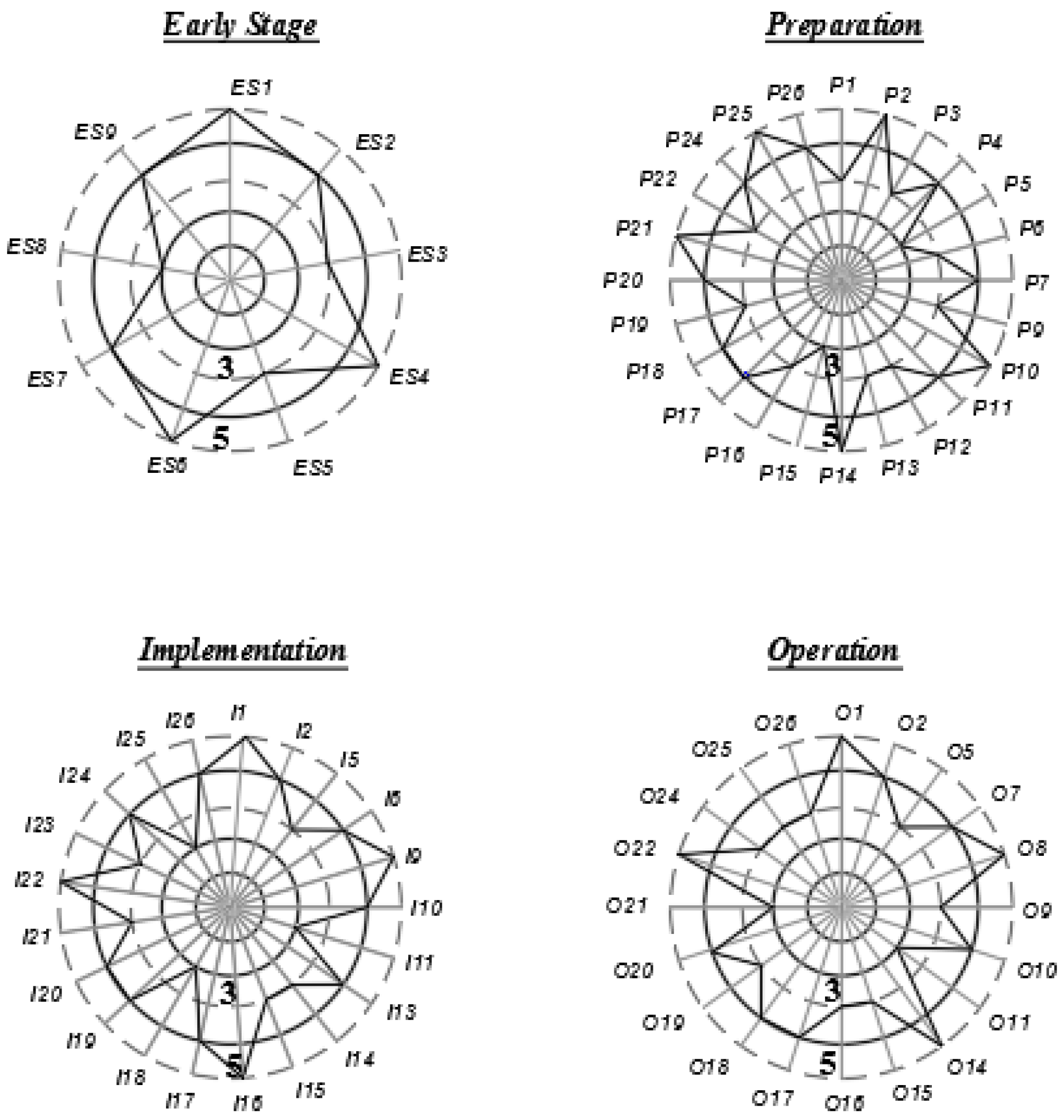
The HSAP protocol provides an approach to evaluate projects across various sustainability dimensions. The assessment employs a scoring system to provide an overall sustainability evaluation, highlighting strengths and identifying areas for improvement. There are 26 criteria for evaluation, depicted on a rosette with five ranking levels ([
12]). These levels range from low performance (value one), to the highest performance (value 5).
Level three is identified as the baseline for sustainability. For an infrastructure project to be considered sustainable, it must attain at least level three or higher in all criteria. Conceptually these are represented in
Figure 1. The evaluation is conducted at various stages of a project’s lifecycle: early stage (ES), preparation (P), implementation(I), and operation (O). The names of the 26 criteria are shown in
Table 1, and detailed description can be found in [
12]. Though criteria are 9 for early stage, 23 for preparation, 21 for implementation and 20 for operation, many criteria are applicable to multiple stages, such as “Governance” and “Communication,” which is relevant for three out of the four stages of a structure’s lifecycle.
The mHSAP method selects 17 out of the 26 criteria to evaluate very old flood protection structures. Their relevance to flood protection within the context of water resources is specifically detailed in column “mHSAP relevant criteria” of the table.
It is important to mention that both HSAP and mHSAP are not a certification scheme for sustainable projects or structures, nor does it replace environmental and social impact assessments required by national policies in a country. Instead, the sustainability assessments provide a snapshot of a structure performance at a specific point in time (either in design phase or in operation). These assessments are advised to be conducted by a team of accredited experts for HSAP or Romanian Waters experts for the proposed mHSAP. The experts visit the project site, review all relevant documents, conduct interviews with stakeholders and operators, and prepare a final report with the results of the assessment. The later identifies gaps that need to be addressed, promoting continuous improvement in sustainability performance. It also facilitates dialogue among the stakeholders through the sharing of results.
Not all criteria are applicable to every structure, as some may be irrelevant for the specific case being evaluated. For instance, water quality for drinking purposes is not pertinent if the water is not intended for consumption. When a criterion is not evaluated, it is listed in the rosetta without a score. The detailed significance of the selected criteria to assess the two structures for flood protection of two Romanian cities are:
Hydrological resource covers the understanding of the availability and reliability of hydrological resources both in the short and long term, taking into account current needs, requirements, and future trends. This is crucial for effective flood risk protection, as it ensures that flood management strategies are based on reliable and up-to-date water resource data.
Infrastructure safety addresses the safety of the evaluated infrastructure with all appurtenance works, aiming to protect lives, property, and communities from the potential consequences of structural failures.
Environmental and Social Impact Assessment and Management focuses on the management processes for environmental and social issues. The main goal is to explore if the negative environmental and social impacts associated with the existing structure are effectively managed, by implementing measures for minimization, mitigation, compensation, and improvement, as well as fulfilling environmental and social commitments.
Erosion and Sedimentation focuses on the responsible management of erosion and sedimentation issues related to the operation of hydrotechnical facilities. When such problems arise, they must be addressed because they are closely associated with the infrastructure safety.
Downstream flow regime refers to ensuring that rules and regulations regarding the defined environmental flow in the downstream are met. Current research addresses flood risk, therefore this criteria is not the most important. However, it was selected to be evaluated because one of the case studies fulfills both protection against floods and against droughts.
Climate change mitigation and resilience normally looks at green house emission. In this research the criteria looks at the role of the structure in climate change adaptation.
Communication and consultation address the engagement with affected communities, governments, key institutions, partners, contractors, watershed residents, etc.
Public Health looks if the structures are affecting the public health in the area surrounding the structure.
Labor and working conditions investigates if there are safe, fair, and equitable working conditions for all employees and contractors.
Governance looks at the internal rules and processes governing the operation of the structure. It also looks at external governance, which involves the legal regulatory framework within which the structure operates.
Integrated Project management addresses the ability of the owner’s flood protection structure to ensure the operation of it in a sustainable manner.
In order to evaluate all of the above criteria, the authors carried out interviews with the Romanian Waters, who are the owners of the structures, checking available documentation and looking at Romanian norms for structures in operation. The outcome of the evaluation for each of the criteria are detailed in section Results and discussion.
2.2. Study Areas
In Romania, historical records indicate that floods account for the majority of disasters, impacting property, infrastructure, human safety, and economic activities ([
13,
14]). Romania’s flood risk strategy is comprehensive, tackling the dual challenges of aging infrastructure and the opportunities offered by new developments. By integrating traditional engineering methods with modern technologies and natural solutions, the country seeks to boost its flood resilience, safeguard communities, and support economic growth. This multi-faceted approach includes upgrading old levees, diversion channels, dams, and drainage systems to meet contemporary standards, ensuring they can handle increased rainfall and extreme weather events driven by climate change ([
15]).
One of the most important policies regarding flood risk is the European Flood Directive, which requires that old structures are assessed regularly, not only for safety but also for sustainability ([
16]). In this context, Romania is constantly applying and revising its regulatory frameworks to ensure that all flood risk management activities adhere to safety and environmental standards ([
17,
18]).
A tool for prioritizing which flood protection structures need improvement is beneficial not only to Romanian Waters but also to all stakeholders involved. Therefore two old structures were selected for evaluation with mHSAP.
2.2.1. The Timis-Bega Canal System
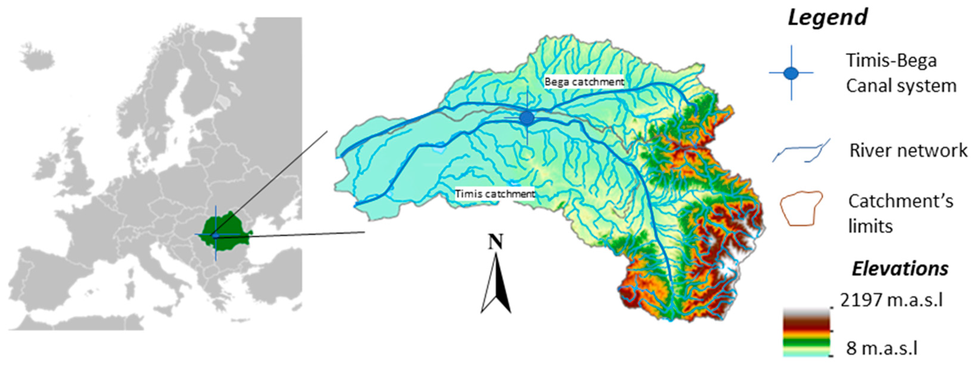
The transboundary Timis-Bega basin (
Figure 2), located mainly in the Banat region of Romania, has a long history of recurrent flooding events. Significant flood events have occurred periodically in the last century, with the highest flow rate recorded at approximately 1600 m³/s in May 1912. The most recent major flood, in 2005, peaked at 1200 m³/s but lasted longer, resulting in a greater overall flood volume. Factors contributing to the frequent occurrence of floods in this area include inadequate natural drainage due to the flat topography, climate conditions, and hydrological characteristics ([
19]).
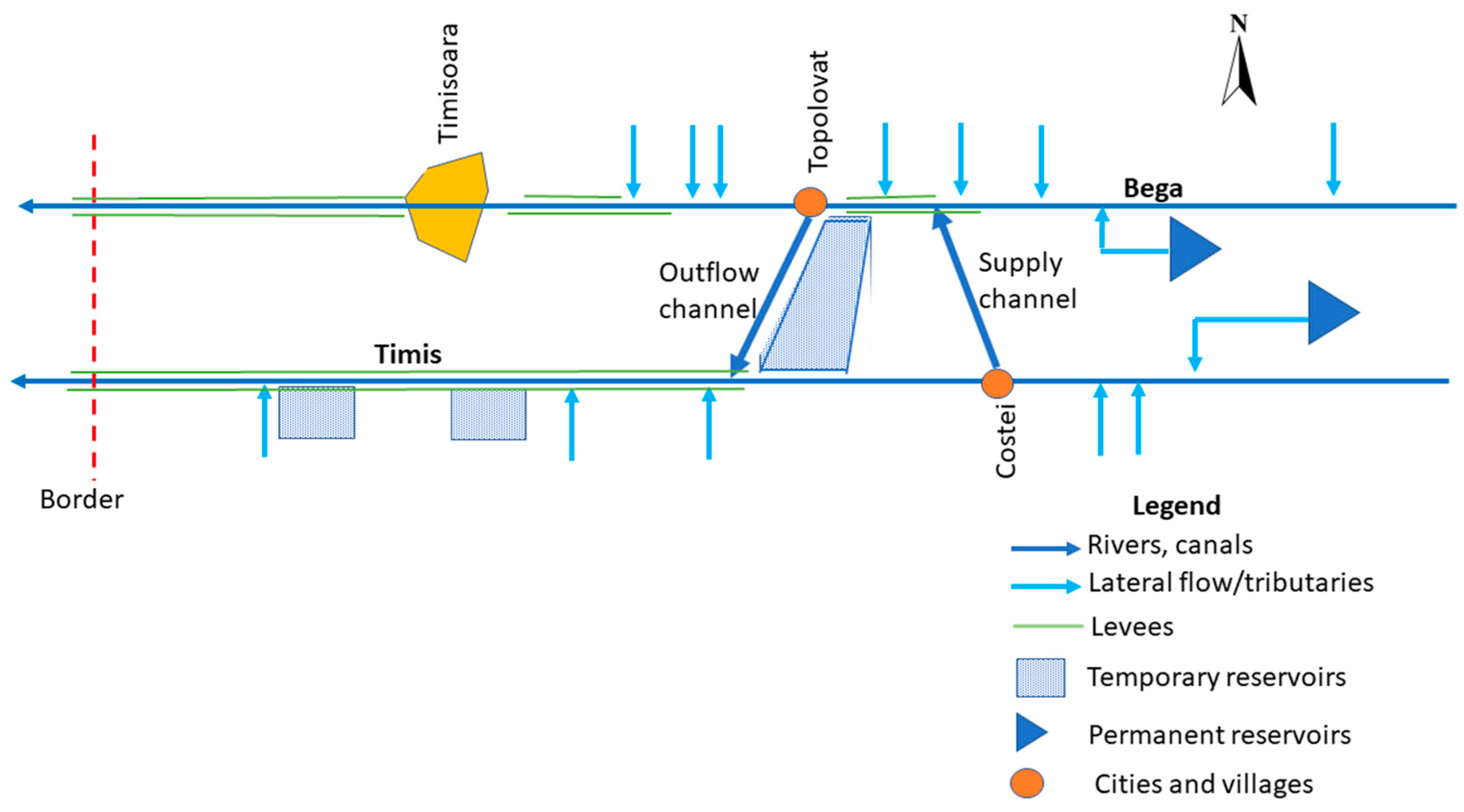
Over the past few centuries, various technological measures have been implemented to mitigate both drought and flood hazards in the Timis-Bega region. The Timiș-Bega Canal System is the most crucial infrastructure for protecting the city of Timișoara. It regulates the water flow of the Timiș and Bega rivers to mitigate flood risks and safeguard the city. Additional flood protection measures include developing canal networks, constructing diversion dikes and temporary (nonpermanent) reservoirs, correcting river track, and levees ([
20,
21]), all presented schematically in
Figure 3.
The Timiș-Bega Canal system, built in 1757, consists of one gated gravity-based water flow diversion channel connecting the Bega to the Timiș river at Topolovăț, and the other a diversion channel connecting the Timiș with the Bega at Coștei, where there is a dam on Timis (see
Figure 3).
During droughts in the Bega river, water from the Timiș river flows towards the Bega, ensuring a water supply to Timișoara. Conversely, when the Bega river experiences flooding, water is diverted to the Timiș river to protect the city from flood risk.
Figure 4 shows a view of the canal at Topolovat, at the gate (a) and downstream the gate(b).
The flood protection works are owned by the National Administration “Romanian Waters,” and the operating unit is the Banat Water Basin Administration.
2.2.2. The Deva city Dike Protection System
Deva, a city situated in the Hunedoara County of Romania, is known for its rich history and cultural significance. However, like many other regions and cities in Romania, Deva has not been immune to natural disasters, particularly floods ([
23,
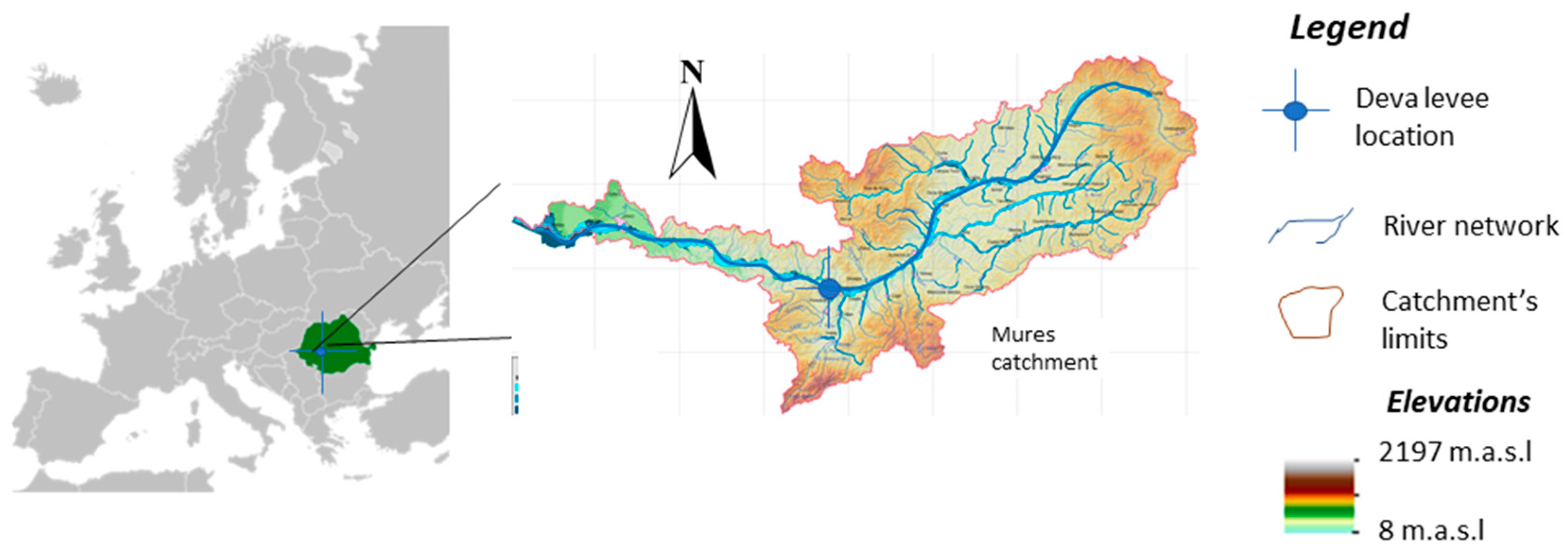
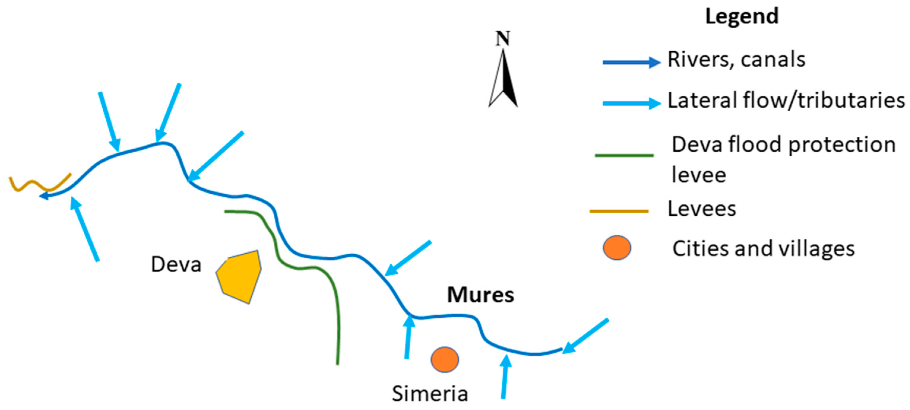
24]). The Mureş River forms the northern boundary of the city of Deva over a length of approximately 5 km. The Mureș River basin, partially represented in
Figure 5, is surrounded by hills, making the city prone to heavy rainfall and subsequent river overflow. Historical records indicate that Deva has experienced multiple flooding events, with some of the most notable occurring in the 20th and early 21st centuries. One of the earliest recorded significant floods in Deva occurred in 1910, causing substantial damage to infrastructure and houses. The floodwaters, driven by intense rainfall, led to the overflowing of the Mureș River, inundating large parts of the city. In the 1970s, Deva was subjected to another series of floods. The 1970 flood, assessed at a 1% probability, caused significant damage, affecting buildings, economic units, institutions, and agricultural lands within the city of Deva. This event highlighted the need for better flood management and the construction of protective barriers ([
25]). Therefore, “Flood Protection of the City of Deva” project was developed and implemented between 1975 and 1977.
The key component of Deva’s flood protection strategy mitigating the impact of future floods are the dams and reservoirs on Mureș River, and the reinforcement of riverbanks with levees ([
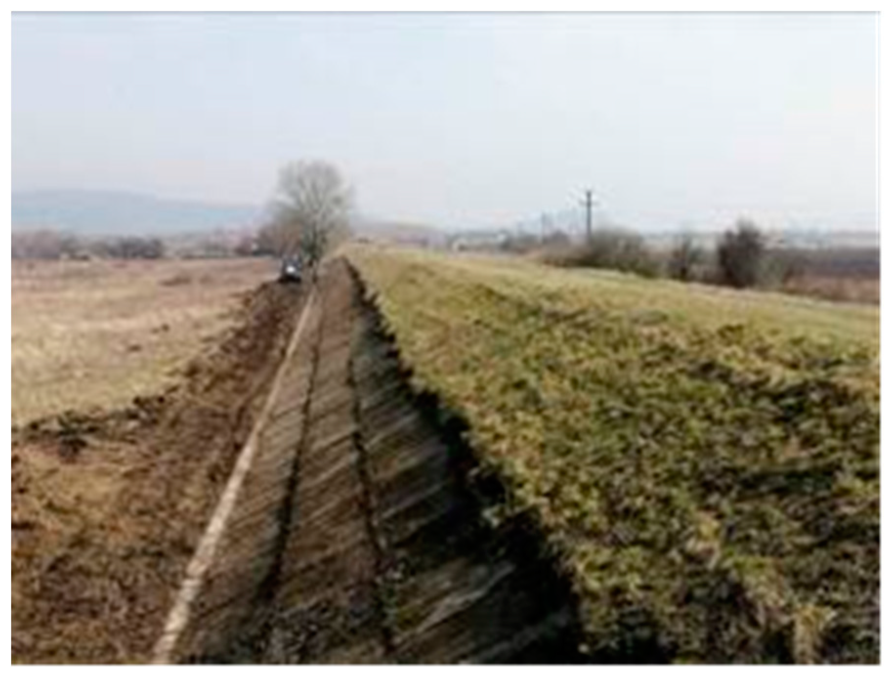
25]). Structurally, the flood protection closest to Deva city consists of an earth dyke (
Figure 6), with an average height of 5 meters, a crest width of 4 meters, and a sealing system featuring a clay core. It consists of two sections with a total length of approximately 8.8 km. The levee is situated on the left bank of the Mureş River and aims to protect the city of Deva from floods caused by the overflow of the river. There are two sections of the dyke, section 1 approximately 2.5 km long that serves as a backwater dyke, while section 2 is a longitudinal dyke equipped with a berm.
Figure 7 shows an overview of the dyke.
The flood protection works are owned by the National Administration “Romanian Waters,” and the operating unit is the Mureş Water Basin Administration, Hunedoara Water Management System.
3. Results and Discussion
For each of the case studies an HSAP evaluation was carried out by conducting interviews with operators of the structures, with Romanian Waters Authority, and with visits onsite to evaluate the status of the structures. Several stakeholders who benefit from the existance of these structures have been contacted and open discussion about the benefit of the structures took place. The scoring values used for assessment were based on the best practices level for the specific evaluated criterion. Score 1 is given for severely lacking basic practices, suggesting that essential sustainability measures are either missing or highly insufficient. Score 2 show that the most relevant aspects of basic good practices have been implemented, but there is a notable deficiency, suggesting that while some effort has been made, it falls short of adequately addressing the sustainability concern. Score 3 show that fundamental good practices concerning a specific sustainability theme are present, which is the threshold for showing that the sustainability is well addressed, but there is room for improvement. Score 4 show that all elements of fundamental good practice have been done, and in some instances, surpassed, but there is a clear shortfall in meeting the criteria for best practice. This level indicates a high degree of compliance with good practices, yet it is not reaching the maximum possible for the best practices. Score 5 characterizes proven best practices on a particular sustainability issue. At this stage, all measures exceed the criteria for best practices, demonstrating excellence in sustainability.
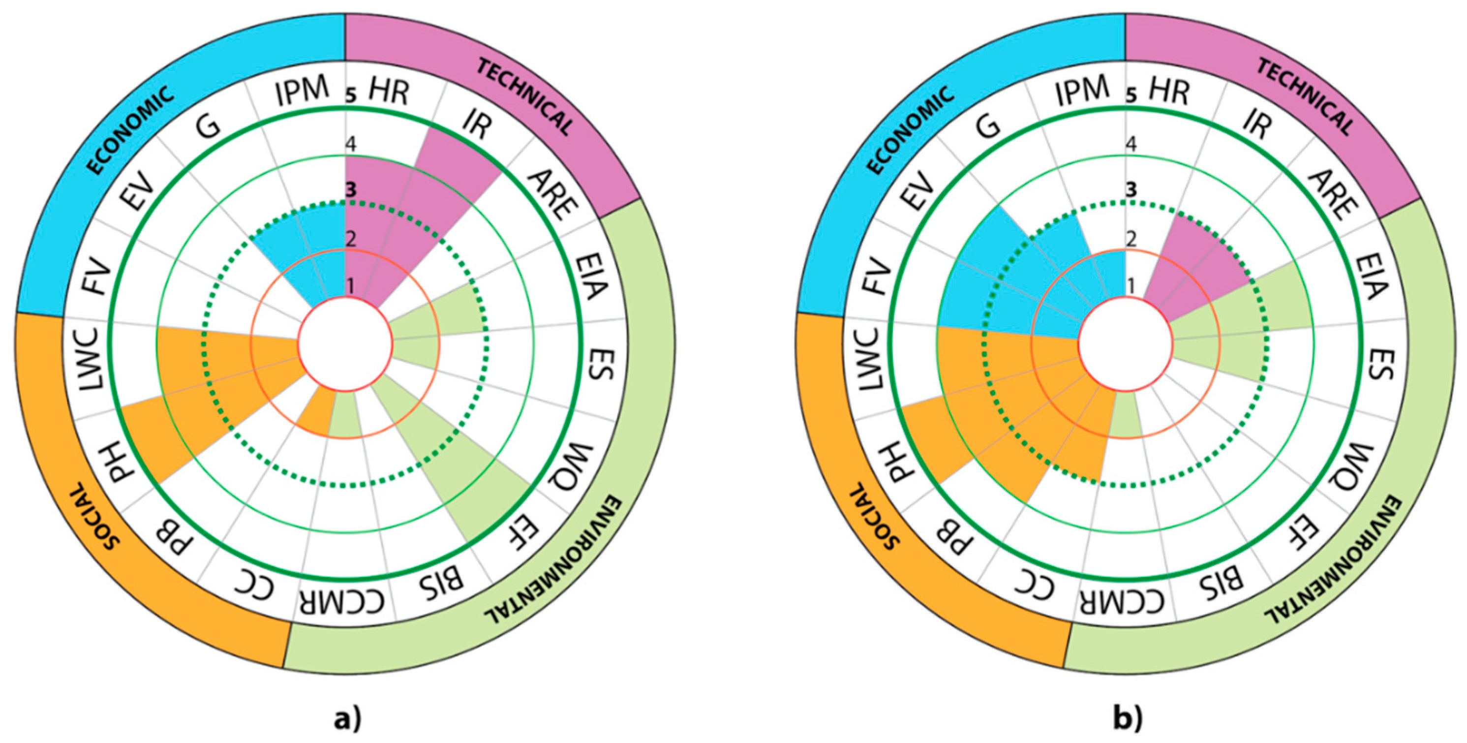
The scores obtained for each of the case studies are presented in
Table 2, and represented in rosettas in
Figure 8.
The HR scoring for Timis-Bega canal system (TBS) is 4, showing a good level of information. We found a series of data sources available at ABA Banat, showing inflow hydrographs and rainfall analysis for the Timis-Bega river. Moreover, there is a dense hydrographic measuring station network that provides timely information, along with prognosis and synthetic hydrographs. However, studies regarding the correlation of measured water levels with discharge values would be a good addition, especially looking at climate change challenges. There are no estimations of future climate change scenarios at the local administration, just at national central level. In case of the Deva levee (DL), the HR analysis is done at the level of Mures catchment, not for the 8 km long dyke.
The infrastructure safety is very well documented and maintained for the TBS, while for DL at visual inspection the dyke is well maintained (
Figure 7), we could not find documentation regarding calculation of structural strength and the expert evaluation is done for a portion of the dyke only.
The erosion and sedimentation of structures is done for the DL through visual inspection regularly, and reports do not show any problems, there is a good maintenance of the dyke. Improvements could be done by introducing sesnsors for dyke erosion during flood. In case of TBS the score is low, best practice is not yet achieved because measurements of the solid flow are done only for the suspended flow, not the dragged flow, due to the lack of appropriate programs and technology.
Climate change is a criterion that needs more work and improvement for both evaluated structures. Both TBS and DL functioned well during devastating floods, for very high values of discharge. However, we could not find studies at present, with clear climate change estimations for the analyzed cases, nor are there any measurements of gas emissions. Improvements are needed.
Though there are a series of communication policies and procedures, they are mainly restricted to announcements in case of hazards, and stakeholder involvement is not done based on a plan. Hence the Communication and consultancy shows a need for improvement. All the other criteria from the social aspects of sustainability are well achieved and documented. They all follow national policies and European Union regulations.
In terms of IPM, the Banat administration is having a good management of the structure, and is certifying it regularly, testing how gates are operated and how water flows. Canals are well maintained. The DL structure, though has the Romanian Water authorization for functioning, it is still missing several technical and environmental evaluations.
4. Conclusions
Current analysis shows that there are many tools available that can be used to assess a flood risk longterm operated structure for sustainability. All findings are useful and potentially can support water decision-making, leading to more resilient and sustainable water resources management.
Conducting a sustainable analysis of old infrastructure for flood risk analysis is very important because it helps identify the strengths and weaknesses of existing structures, ensuring that they meet current safety and performance standards ([
26]). Such analysis often reveals potential vulnerabilities, and areas that require immediate attention, not only at structural level but also at governance level.
Given the historical importance of the TimisBega canal system such evaluations provide valuable insights into the cultural significance of the infrastructure, guiding preservation efforts. They ensure that while modernizing, the historical integrity and cultural heritage of the infrastructure are maintained.
Studies like the one carried out during this research can help determining necessary updating to the structures, such that in time the maintainance costs are reduced and the environmental impact is minimized, while still serving the flood risk mitigation purpose for which they have been designed.
Author Contributions
Conceptualization and methodology, I.P, CT., and CMC.; interviews, data and data curation, CT, CMC and RA; investigation and formal analysis, IP, CF and AC; writing—original draft preparation, CT and IP; writing—review and editing, IP, and AC.; supervision, IP and CF. All authors have read and agreed to the published version of the manuscript.
Funding
This research received no external funding.
Acknowledgments
The authors wish to acknowledge The Romanian Waters Authority “Apele Romane” - ANAR, specifically the ABA Banat and ABA Mures directorate, owners of the Timis-Bega canal system and Deva levee respectively, who kindly allowed the research team access to conduct interviews and providing all the essential information and documentation.
Conflicts of Interest
The authors declare no conflict of interest.
References
- National Research Council, U.S. Committee On Integrating Dam And Levee Safety And Community Resilence. Dam and Levee Safety and Community Resilience: A Vision for Future Practice. Washington, D.C.: National Academies Press, 2012. Web.. https://lccn.loc.gov/2012288835.
- United Nations. (2015). Transforming Our World: The 2030 Agenda for Sustainable Development. Retrieved from https://sustainabledevelopment.un.org/post2015/transformingourworld/publication.
- World Bank. (2017). High and Dry: Climate Change, Water, and the Economy. Retrieved from https://www.worldbank.org/en/topic/water/publication/high-and-dry-climate-change-water-and-the-economy.
- Owusu, A.; Salazar, J.Z.; Mul, M.; van der Zaag, P.; Slinger, J. Quantifying the trade-offs in re-operating dams for the environment in the Lower Volta River. Hydrology and Earth System Sciences 2023, 27, 2001–2023. [Google Scholar] [CrossRef]
- Godinez Madrigal, J.; van Cauwenbergh, N.; Ochoa-Garcia, H.; van der Zaag, P. Can grassroots movements in water conflicts drive socio-technical transitions in water management systems? Environmental Innovation and Societal Transitions 2024, 51, 100837. [Google Scholar] [CrossRef]
- Teau, C.; Popescu, I.; Florescu, C.; Constantin, A.; Ciocan, C.M.; Vlaicu, V. Implementation of water related Sustainable Development Goals in Romania: overview of current and future challenges. In IOP Conference Series. Earth and Environmental Science 2023, 1136, 012013. [Google Scholar] [CrossRef]
- IPCC (Intergovernmental Panel on Climate Change). (2021). Climate Change 2021: The Physical Science Basis. Cambridge University Press.
- Parker, D.J. Disaster resilience – a challenged science. Environmental Hazards 2019, 19, 1–9. [Google Scholar] [CrossRef]
- Xu, Z.; Chau, S.N.; Chen, X.; Zhang, J.; Li, Y.; Dietz, T.; Wang, J.; Winkler, J.A.; Fan, F.; Huang, B.; Li, S.; Wu, S.; Herzberger, A.; Tang, Y.; Hong, D.; Li, Y.; Liu, Y. Assessing progress towards sustainable development over space and time. Nature 2020, 577, 74–78. [Google Scholar] [CrossRef] [PubMed]
- Lyon, K. 2020. “Using the Hydropower Sustainability Tools in World Bank Group Client Countries: Lessons Learned and Recommendations.” World Bank, Washington, DC.
- Popescu, I., Teau, C, Florescu, C, Constantin, A, (2024) Modified methodological framework for sustainability evaluation of existing hydraulic structures in Romania: the case study of Cincis dam, Hunedoara, Geoecomarina Journal (available online August2024).
- HSAP (2022) Hydropower Sustainability Assessment Protocol available from https://www.hydrosustainability.org/ (last accessed March 2024).
- Romanescu G, Cimpianu CI, Mihu-Pintilie A, Stoleriu CC (2017) Historic flood events in NE Romania (post-1990). Journal of Maps 13: 787-798.
- Popa, M.C.; Peptenatu, D.; Drăghici, C.C.; Diaconu, D.C. Flood Hazard Mapping Using the Flood and Flash-Flood Potential Index in the Buzău River Catchment, Romania. Water 2019, 11, 2116. [Google Scholar] [CrossRef]
- World Bank (2018), Romania Water Diagnostic Report: Moving toward EU Compliance, Inclusion, and Water Security, World Bank, Washington, DC.
- Fatica, S.; Kátay, G.; Rancan, M. Floods and firms: vulnerabilities and resilience to natural disasters in Europe.
- European Commission, Ispra, 2022, JRC132125.
- Zaharia, L.; Costache, R.; Prăvălie, R.; Ioana-Toroimac, G. Mapping flood and flooding potential indices: A methodological approach to identifying areas susceptible to flood and flooding risk. Case study: The Prahova catchment (Romania). Front. Earth Sci. 2017, 11, 229–247. [Google Scholar] [CrossRef]
- Copetti, D.; Erba, S. A bibliometric review on the Water Framework Directive twenty years after its birth. Ambio 2024, 53, 95–108. [Google Scholar] [CrossRef] [PubMed]
- Moya-Gomez, V.; Popescu, I.; Solomatine, D.; Bociort, L. Cloud and cluster computing in uncertainty analysis of integrated flood models. J. of Hydroinformatics 2013, 15, 55–69. [Google Scholar] [CrossRef]
- Chendeș, V.; Corbuș, C.; Petreș, N. (2015) Characteristics of April 2005 flood event and affected areas in the Timiș-Bega plain (Romania) analysed by hydrologic, hydraulic and gis methods. Proceedings of the 15th International Multidisciplinary Scientific GeoConference, SGEM 2015, Water Resources Forest, Marine and Ocean Ecosystems, Albena, Bulgaria: 18-24.
- Popescu, I.; Jonoski, A.; Van Andel, S.; Onyari, E.; Moya Quiroga, V. Integrated modelling for flood risk mitigation in Romania: case study of the Timis–Bega river basin. International journal of river basin management 2010, 8, 269–280. [Google Scholar] [CrossRef]
- Niculae Iulian Teodorescu 2008 IOP Conf. Ser.: Earth Environ. Sci. 4 012017. [CrossRef]
- Gresita, C.I.; Musat, E.C.; Maican, I. Monitoring the behavior of the dam of a big water reservoir by geodethic methods, International Multidisciplinary Scientific GeoConference Surveying Geology and Mining Ecology Management. SGEM 2019, 19, 261–268. [Google Scholar] [CrossRef]
- Mihai, F.-C.; Minea, I.; Ulman, S.-R. (2023) Water resources preservation through circular economy: The case of Romania Water Management and Circular Economy, pp. 143–176. [CrossRef]
- ABA Mures (2016) Planul de de management al riscului la inundaţii, (available at https://www.mmediu.ro/app/webroot/uploads/files/2016-03-24_RO7_FRMP_PMRI_MURES.pdf).
- Beevers, L.; Popescu, I.; Pregnolato, M.; Liu, Y.; Wright, N. Identifying hotspots of hydro-hazards under global change: A worldwide review. Front. Water 2022, 4, 879536. [Google Scholar] [CrossRef]
|
Disclaimer/Publisher’s Note: The statements, opinions and data contained in all publications are solely those of the individual author(s) and contributor(s) and not of MDPI and/or the editor(s). MDPI and/or the editor(s) disclaim responsibility for any injury to people or property resulting from any ideas, methods, instructions or products referred to in the content. |
© 2024 by the authors. Licensee MDPI, Basel, Switzerland. This article is an open access article distributed under the terms and conditions of the Creative Commons Attribution (CC BY) license (http://creativecommons.org/licenses/by/4.0/).
