Submitted:
24 September 2024
Posted:
25 September 2024
You are already at the latest version
Abstract
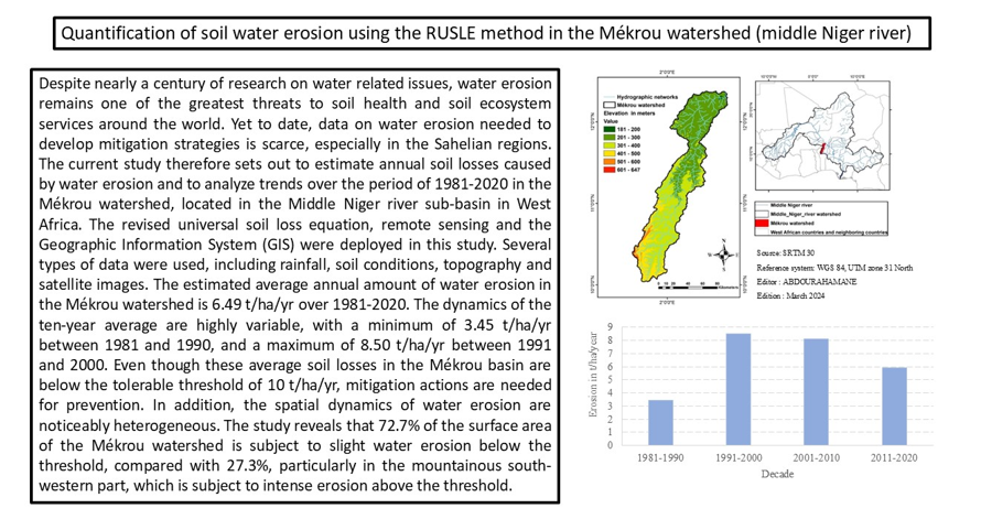
Despite nearly a century of research on water related issues, water erosion remains one of the greatest threats to soil health and soil ecosystem services around the world. Yet to date, data on water erosion needed to develop mitigation strategies is scarce, especially in the Sahelian regions. The current study therefore sets out to estimate annual soil losses caused by water erosion and to analyze trends over the period of 1981-2020 in the Mékrou watershed, located in the Middle Niger river sub-basin in West Africa. The revised universal soil loss equation, remote sensing and the Geographic Information System (GIS) were deployed in this study. Several types of data were used, including rainfall, soil conditions, topography and satellite images. The estimated average annual amount of water erosion in the Mékrou watershed is 6.49 t/ha/yr over 1981-2020. The dynamics of the ten-year average are highly variable, with a minimum of 3.45 t/ha/yr between 1981 and 1990, and a maximum of 8.50 t/ha/yr between 1991 and 2000. Even though these average soil losses in the Mékrou basin are below the tolerable threshold of 10 t/ha/yr, mitigation actions are needed for prevention. In addition, the spatial dynamics of water erosion are noticeably heterogeneous. The study reveals that 72.7% of the surface area of the Mékrou watershed is subject to slight water erosion below the threshold, compared with 27.3%, particularly in the mountainous south-western part, which is subject to intense erosion above the threshold.
Keywords:
water erosion
; remote sensing
; Mékrou watershed
; middle Niger river
; West Africa
1. Introduction
Soil erosion by water is a global phenomenon that leads to land degradation [1,2] and affects around 2.6 billion people in more than 100 countries worldwide [3]. The highest rates of land degradation, exacerbated by climate change associated with human activities, are recorded in Asia, followed by Africa and Europe [4]. Given that having soil in good physico-chemical conditions is the basis for good agricultural production, water erosion is a real threat to food security, particularly in highly vulnerable countries such as those in the Sahel. It is the main factor in the degradation of the fertile layer of agricultural land, exacerbating the loss of soil nutrients [5].
Soil erosion is a natural process that’s severity and extent depend on the interaction of various factors, including climate, topography, soil type and land use [6,7]. However, in most cases, this process is greatly worsened by human activities a human-induced erosion characterized by the deforestation and abusive agricultural practices, [8].
Since the years of long droughts in the Sahel, there has been a profound change in the Sudano-Sahelian landscapes, notably through the degradation of vegetation, desertification, changes in river flow regimes, accelerated silting up of several rivers and reservoirs, the gullying of slopes, and aridification of the regional microclimate [9,10]. This combination of factors makes the Sahel one of the most sensitive regions to water erosion in the world [11,12] . This is a major constraint on the success of agro-sylvo-pastoral development projects based on the rational use of soil, water and plant cover [12].
Most of the studies conducted in the West African sub-region to gain a better understanding of the problem of water erosion focused on measuring runoff and soil loss at the scale of experimental plots [12,13,14]. The impact of such studies is limited when the phenomenon is spatially heterogeneous. Thus, in order to develop effective mitigation strategies for this scourge to ensure better land productivity and to strengthen the resilience of communities whose main activity is agriculture, it is important to carry out a spatio-temporal analysis on a larger scale.
In the Mékrou watershed, erosion is a problem essentially linked to agro-pastoral practices, deforestation activities and bush fires denuding the land which, due to torrential rainfall, is subject to heavy erosion in some parts. This erosion washes and drains various wastes and sand into streams and water bodies, contributing not only to water pollution but also to the filling up of water bodies and streams [15] . It is within this framework that the Mékrou watershed was chosen as the case study for this research, which is a typically Sahelian and highly anthropised watershed with enormous issues at stake.
2. Presentation of the Mékrou River Watershed
The Mékrou is one of the nine tributaries of the middle section of the Niger river, six of which (Gorouol, Dargol, Sirba, Goroubi, Diamangou and Tapoa) have their sources in Burkina Faso, while the other three (Alibori, Sota and the Mékrou) have their sources in Benin [16] . Its watershed area covers 10,500 km², 36% of which is farmland and 20% is agricultural mosaic and dry vegetation. Parts of it lies in Benin (79%), in Burkina Faso (12%) and in Niger (9%) (Figure 1).
In the Mékrou basin, the climate is Sudano-Sahelian and the vegetation is dominated by tree and shrub savannas with a strong agricultural influence. The forest gallery extends along the watercourses with the presence of saxicolous savannah [16] . The relief consists mainly of plains, especially in the north-western part. Slopes are generally low to moderate with the exception of the more mountainous south-western area where they are steep.
The populations living in the Mékrou basin practice agriculture as their main economic activity. Apart from agriculture they also practice as other activities the breeding of large livestock, transhumance, fishing, hunting, handicrafts, logging, and trade in agricultural products [15] . It should be noted that these activities exert pressure on natural resources, which are gradually dwindling.
3. Materials and Methods
3.1. Data and Tools Used
Several set of data was used in this study. These were (i) monthly rainfall data from 1981 to 2020 in raster format, with a spatial resolution of 0.5x0.5° (i.e. 55.5x55.5 km) covering the entire Mékrou watershed; (ii) the FAO soil map on a scale of 1:5.000.000 ; (iii) the SRTM image of the study area in raster format and with a spatial resolution of 30 m; and (iv) Landsat 4-5, 7 and 8 images from 1990, 2000, 2010 and 2020 with a spatial resolution of 30 m.
The rainfall data was extracted from « the University of East Anglia database » and the soil map from the FAO database. The SRTM and Landsat images were taken from « the United States Geological Survey (USGS) ».
The main processing tools used to achieve the objective of this study are QGIS 3.20.1 for processing Landsat images and ArcGIS 10.8 for calculating the various factors and estimating annual soil losses caused by water erosion.55.5km x 55.5km
3.2. Data Analysis Methods
The RUSLE model, widely used [17] by researchers, which is the revised version of the universal soil loss equation, was chosen to quantify mean annual water erosion in the Mékrou watershed. This choice was based above all on the availability of data for this watershed, on climatic, topographical and soil parameters, and on land use and conservation methods. It is presented in the form of equation (1):
where A - is the estimated annual soil loss (t/ha/yr); R - is the rainfall erosivity factor (MJ.mm/ha.h.y); K - is the soil erodibility factor (t.ha.h/ha.MJ.mm); LS - is the topographical factor (dimensionless); C - is the vegetation factor (dimensionless); and P - is the soil conservation and protection practices factor (dimensionless).
Each of the components of formula (1) is estimated independently according to the following criteria and formulas:
- The precipitation erosivity factor (R):
This factor is an indicator of the potential of precipitation to induce soil loss through the detachment and transport of particles. It is a function of several precipitation-related parameters, including quantity, energy, duration, intensity, drop size, type of precipitation and the resulting runoff rate [1,18] . However, in order to enable its estimation in view of the lack of data, in particular rainfall intensity [19], following his research in some countries in Africa (Côte d'Ivoire, Burkina Faso, Senegal, Niger, Chad, Cameroon and Madagascar), proposed the following linear equation, as a function of annual rainfall alone:
Specifically for the West Africa sub-region, it is suggested taking the dividend α = 0.5 (i.e. R = 0.5* Pl; where Pl is the annual rainfall in mm).
- The soil erodibility index (K):
This index takes values between 0 and 1. The less sensitive the soil is to water erosion, the more K tends towards 0 [1]. Originally, the K factor was determined experimentally as a function of soil texture and structure, organic matter content and permeability [20,21,22]. In this study, however, the Williams [23] equation was used (Formula 3), which relates the K factor to soil properties (clay, sand and silt content, and organic carbon fraction) available in the FAO database for the Mékrou watershed (Table 1).
where the components Fcsand, Fcl-si, Forgc, and Fhinsand characterize the composition of the soil in terms of sand, clay/silt, organic and carbon respectively. They are calculated by the following formulae 4 to 7:
where ms is the percentage of sand (diameter 0.05-2.00 mm); msilt, the percentage of silt (diameter 0.002-0.05 mm); mc, the percentage of clay (diameter < 0.002 mm); and orgC,the organic carbon content (%).
- The topographical factor (LS) :
The topographic factor LS indicates the gradient responsible for runoff velocity. The steeper the slope of the land, the higher the velocity and erosive potential of the runoff [24,25]. The Formula (8) of Moore and Burch [26] below was used to calculate the LS factor:
where flow accumulation represents the cumulative upstream contributing area for a given cell, Cell size is the size of the pixel which is 30 m resolution, 22.13 is a uniform length (m) to avoid uncertainties related to the influence of the length of the slope on erosion, Sin Slope is the sine of the slope and 0.0896 is a constant.
- The vegetation factor (C):
This factor represents the effect of cultivation and land management practices on erosion. It is closely linked to land use types and therefore depends mainly on vegetation type, growth stage and vegetation cover rate. The C factor was estimated using the equation of Durigon [27] , which will subsequently be improved by Colman [28] in certain regions as a function of the NDVI value (Formula 9).
where , NIR is the near infrared part of the electromagnetic spectrum and RED is the red part of the electromagnetic spectrum.
The Normalised Difference Vegetation Index (NDVI), also known as relative biomass, is a standardized index that allows users to generate images displaying greenness. NDVI uses the properties of red (RED) and near infrared (NIR) light to quantify vegetation, which can be useful for classifying high and low vegetation and indicating drought.
In the current study, NDVI is established using Landsat images introduced in the ARCGIS 10.8 tool and assigned band values according to the Landsat image type.
For the Landsat 4-5 and 7 images, band 4 is used for the near infrared (NIR) and band 3 for (RED), which is the red part of the electromagnetic spectrum.
As for the Landsat 8 images, band 5 is employed for the near infrared (NIR) and band 4 for (RED), which is the red part of the electromagnetic spectrum.
- The soil conservation and protection practices (P):
The values of the P factor, ranging from 0 to 1, depend on the soil conservation and protection practices implemented to mitigate soil erosion (Table 2), such as contour farming, terraces and strip cropping [29]. The closer P is to 0, the greater the soil's resistance to human-induced erosion; conversely, the closer it is to 1, the lower the soil's resistance.
By combining all the information related to the quantification of water erosion in the Mékrou watershed, the latter was calculated for the study period (1981-2020) and for the decades 1981-1990, 1991-2000, 2001-2010 and 2011-2020. Water erosion was mapped for each of the 10-year sub-periods, and a cross-comparison was made to analyze the spatiotemporal dynamics of erosion at the scale of the Mekrou watershed.
4. Results and Discussion
The results obtained from this study are presented and discussed in three different sections: (3.1) main morphometric and pedological characteristics of the Mékrou watershed, (3.2) factors characterizing soil erosion, and (3.3) spatio-temporal dynamics of erosion in the Mékrou watershed.
4.1. Main Morphometric and Soil Characteristics
The various morphometric, pedological and climatic characteristics essential for quantifying water erosion in the Mékrou watershed are presented below:
The Mékrou watershed has a surface area of 10500 km² and a perimeter of 1154.16 km. It therefore falls into the category of elongated basins, with a Gravelus compactness index of 3.18. It has a longitudinal South-North orientation. Topographically, the Mékrou basin lies between 181 and 647 m above sea level.
There are four soil types: (1) Ferric Luvisols, (2) Eutric Gleysols, (3) LITHOSOLS and (4) Gleyic Luvisols. The NDVI index shows fairly large differences between its extreme values, which are -0.175 and 0.552. Savannah (trees and shrubs) is the dominant plant unit.
West Africa in general, and the Mékrou basin of the Niger River in Benin in particular, has two contrasting seasons: a dry season and a rainy season. The geographical area of the basin is characterized by a concentration of rainfall (96% annual average) over six months (May-October) [30], similar to the seasonal pattern of rainfall in Sudano-Sahelian countries. The annual rainfall for the period 1981-2020 used in this study in the basin with data from the University of East Anglia database varies from 542 mm to 1008 mm, with an average of 780 mm within the basin. Temperatures on both sides of the basin are generally high. Average annual temperatures are recorded at between 27.5°C and 29°C, although these temperatures conceal major disparities between extreme temperatures, the maximum of which often reaches and exceeds 45°C in the shade in April [31]. The lowest temperatures are observed in July-August, while the highest values are observed in April-May, with peaks of up to 45°C in the shade[31].
4.2. Estimates of Water Erosion Components in the Watershed
- The precipitation erosivity factor (R):
Estimated as a function of the average amount of rainfall received by a watershed, the average values of this factor over the Mékrou watershed for the entire study period and the four defined decades are shown in Figure 2. This shows an upward shift in the average between the 1981-1990 and 1991-2000 decades, from 350.4 to 401.8 MJ.mm/ha.h.yr, i.e. an increase of 14.7%. This can be explained by the return of wetter conditions since the 1990s in some parts of the Sahel and since the 2010s in others, following the long period of drought in the 1970s and 1980s [32]. The amplitude of the R factor has also increased. However, since 1991-2000, decadal values of the R factor have varied very little, in terms of both mean and amplitude, until 2011-2020. Finally, from 1981 to 2020, the average annual value of R varies from 271.3 (in the south of the watershed) to 503.8 MJ.mm/ha.h.yr (in the north of the watershed), with an estimated inter-annual average of 390.4 MJ.mm/ha.h.yr. In fact, the spatial distribution of the R factor is not uniform across the Mékrou watershed (Figure 2); it naturally reflects that of the rainfall to which it is directly linked as illustrated in Formula 2, i.e. decreasing from the south to the north of the watershed [16] (JRC, 2017).
- The soil erodibility index (K) and the topographical factor (LS):
The soils within the Mékrou watershed are of four types and vary greatly in area, spreading over 12 distinct zones. Based on these, the K factor (in t.ha.h/ha.MJ.mm) calculated for each soil type is shown in Table 3. It varies considerably according to soil type. For example, K is 0.1382 for soil type LG (02.9% of the watershed), 0.1394 for soil I (18.5% of the watershed), 0.1523 (14.7% of the watershed) and 0.2579 for soil type LF (63.9% of the watershed).
The average soil erodibility factor for the entire Mékrou watershed is 0.1930 t.h/ha. MJ.mm.
As for the topographical factor (LS), which is a function of the slopes of the land in the watershed, it varies from 0 to 305, with an average of 0.21 for the catchment as a whole. The relief of the Mékrou watershed consists mainly of plains and gentle to moderate slopes over most of the area. The value of the LS factor is constant for all the time intervals considered in this study.
- The vegetation factor (C) :
This factor, which is inversely proportional to the normalized vegetation index (NDVI), characterizes the watershed's vulnerability to erosion as a function of its vegetation cover. The higher the value of C, the less vegetation is within the watershed and the more vulnerable it is to erosion. The average value of C calculated varies very little from one period to another. It is 0.440 for 1981-1990, 0.424 for 1991-2000, 0.421 for 2001-2010, and 0.414 for 2011-2020. Over the entire study period (1981-2020), the average C factor is 0.42475.
- The soil conservation and protection practices (P):
This factor, which is determined on the basis of land cover and land use types (see Table 3), was evaluated at 0.332; 0.070; 0.095; and 0.079 respectively for the decades 1981-1990, 1991-2000, 2001-2010 and 2011-2020; while the 1981-2020 average is 0.144. According to Wischmeier and Smith (1978), the P factor takes its two extreme values, 0 on managed land and 1 on land without anti-erosion practices. Here, there is considerable variability in P, which can be explained by the profound changes in land use observed within the Mékrou watershed over the years.
The distribution map of each spatially variable component (R, K, LS, C and P) of water erosion over the surface of the Mékrou watershed is shown in Figure 3, for the entire study period considered (1981-2020).
The spatial distribution of the various factors shows that, in general, the R factor, which has a spatial average value of 271.3 MJ.mm/ha.h.yr, is the highest in the southern part of the watershed, where it rains much more. The K factor varies according to soil type, averaging 0.1930 t.h/ha. MJ.mm, although it should be noted that most of the watershed (63.9%) is made up of Ferric Luvisols with an average K value of 0.2579 t.h/ha. MJ.mm. This soil is found in almost all the north-eastern, south-eastern and central parts of the basin, with the other soil types located mainly in the west of the basin. The topographical factor, generally low with an average of 0.21, is relatively high in the mountainous areas of the south-western part of the basin. In the Mékrou watershed, savannah is the dominant vegetation unit, with tree and shrub savannahs that are heavily farmed, reflecting the average C-factor value of 0.42475. Generally speaking, the highest C-factor values are found in the northern and central-western parts of the watershed, although for the 1981-1990 and 2001-2010 decades, high values comparable to those in the north were observed in the south-eastern part of the watershed. Finally, with regard to the agricultural practices factor P, the average value of 0.144 obtained, being closer to 0, representing good agricultural practices, shows us that there are still good agricultural practices in the Mékrou watershed. The spatialization of this factor shows that the best agricultural practices are carried out in the central and southern parts of the basin for three of the decades, with the exception of the 1981-1990 decade, where we observe the worst agricultural practices with high values of P in the south of the basin, especially in the mountainous areas, and the best agricultural practices in the central part of the watershed.
4.3. Estimated Soil Losses Due to Water Erosion in the Mékrou Watershed
In the Mékrou watershed, the average annual loss of soil through water erosion varies from 3.45 to 8.50 t/ha/yr depending on the decade. The temporal dynamics at decadal intervals are shown in Figure 4. The change in average annual loss is not uniform; it is lowest between 1981 and 1990 at 3.45 t/ha/yr, then increases exceptionally to reach its maximum value of 8.50 t/ha/yr) during the decade 1991-2000 and finally decreases, first timidly between 2001 and 2010 to 8.10 t/ha/yr then intensely to 5.90 t/ha/yr between 2011 and 2020.
Water erosion was also spatially variable in the Mékrou watershed over the four decades of the study. The spatial distributions of soil losses per decade and for the entire study period are presented in five classes (very low, low, moderate, high, very high) in Figure 5.
The maps in Figure 4 show that water erosion has spread and intensified simultaneously. In fact, the phenomenon, with an intensity ranging from very low (0-5 t/ha/yr) to moderate (10-30 t/ha/yr) over almost the entire watershed, with the exception of the mountainous areas in the south-west where it was high (30-50 t/ha/yr) to very high (> 50 t/ha/yr), has gradually intensified and spread over its entire surface area over the years up to the northern part. At the same time, the different classes intensified up to the weakest class (0-5 t/ha/yr), which was very dominant in a small part of the northern half of the watershed between 1981 and 1990, had practically disappeared, giving rise to classes 5-10 t/ha/yr and 10-30 t/ha/yr between 2011 and 2020.
Water erosion statistics by class and decade are given in Table 4 below.
Looking at these statistics, all the erosion classes have changed significantly over time. However, the dominant erosion class, for all decades, is the very low one, which always remains above 50% despite its decrease over time. In contrast, the other classes have progressed at different rates between 1981 and 2020.
Average annual erosion over the study period is estimated at 6.49 t/ha/yr. This means that there has been an intensification of water erosion in the Mékrou watershed, even if this annual average remains below the tolerable threshold of 10 t/ha/yr according to the FAO, as attested by authors such as Masson [33] and Khemeri [34].
Comparing the results of this study with others, it appears that erosion is more intense in the Mékrou watershed than in the Ouallam Kori in Niger and the Sissili watershed in Burkina Faso, where Salifou [12] and Yameogo [35] respectively obtained average values of 1.54 t/ha/yr and 1.22 t/ha/yr, which are much lower than in the present study. Although the soil is more sensitive to water erosion in the Kori and Sissili watersheds than in the Mékrou watershed, this could be explained by topographical and, above all, climatic factors. However, the results of this study are inferior to those of Akplo [36], who obtained an annual average of 16.2 t/ha/yr in the Zou watershed in central Benin. In other similar regions, such as northern Nigeria in the Urualla watershed and the Katsina state region, Dike [37] and Adediji [38] at al (2018) respectively obtained average soil loss erosion values of 36 t/ha/yr and 17.35 t/ha/yr that are higher than the value we obtained.
5. Conclusion
This study on the analysis of water erosion in the Mékrou watershed made it possible to assess the quantities of soil lost and to understand the spatiotemporal dynamics of this phenomenon. It found that water erosion, which was generally less intense except in the mountainous areas in the south-west, and more marked in the southern part of the watershed at the beginning of the study period, has intensified considerably and is now widespread throughout the Mékrou watershed. However, its temporal trend is not unequivocal, as it increased sharply between the first two decades before declining timidly and continuously over the last two decades. In addition, the study reveals that despite an increase in water erosion in the Mékrou watershed, it remains below the tolerable threshold. Nevertheless, given the reality of the return of a wetter period for at least the last two decades, it is necessary to reduce plant cover and soil degradation practices, and to intensify anti-erosion activities in the Mékrou watershed in order to reverse the water erosion curve in the long term.
Author Contributions
Conceptualization, R.A.A., H.D., J.A. and R.L.; methodology, R.A.A. and H.D.; software, R.A.A.; writing—original draft preparation, R.A.A., H.D., J.A. and R.L.; writing—review and editing, R.A.A., H.D., J.A. and R.L; visualization, R.A.A., H.D., J.A. and R.L.; supervision, H.D., J.A. and R.L. All authors have read and agreed to the published version of the manuscript.
Funding
This paper is part of a doctoral research initiative, generously funded by the German. Federal Ministry of Education and Research (BMBF) through the West Africa Science Center of Climate Change and Adapted Land Use (WASCAL).
Institutional Review Board Statement
Not applicable.
Informed Consent Statement
Not applicable.
Data Availability Statement
Not applicable.
Acknowledgments
This research is a part of a PhD study conducted under the auspices of the West African Science Service Center on Climate Change and Adapted Land Use (WASCAL) program.
Conflicts of Interest
The authors declare no conflict of interest.
References
- B.P. Ganasri and H. Ramesh, “Assessment of soil erosion by RUSLE model using remote sensing and GIS - A case study of Nethravathi Basin,” Geosci. Front., vol. 7, no. 6, pp. 953–961, 2016. [CrossRef]
- D.J.A.M. Ostovari, D.S. Ghorbani, H.A. Bashrami, M. Naderi, “Soil loss prediction by an integrated system using RUSLE, GIS and remote sensing in semi-arid regionle,” Geoderma Reg., vol. 1111, 2017, [Online]. Available: https://doi.org/10.1016/j.geodrs.2017.06.003. [CrossRef]
- M. Schauer, “THE E CONOMICS OF The Economics of Land Degradation in Africa Benefits of Action Outweigh the Costs A complementary report to the ELD Initiative,” p. 151 pages, 2015, [Online]. Available: isbn: 978?92-808?6064-1%5CnThis ELD report was published with the support of the partner organisations of the ELD Initiative and Deutsche Gesellschaft fu? r Internationale Zusammenarbeit (GIZ) GmbH on behalf of the German Federal Ministry for Economic Coop.
- M.C. Singh, K. Sur, N. Al-Ansari, P.K. Arya, V. K. Verma, and A. Malik, “GIS integrated RUSLE model-based soil loss estimation and watershed prioritization for land and water conservation aspects,” Front. Environ. Sci., vol. 11, no. March, 2023. [CrossRef]
- K. Balasubramani, M. Veena, K. Kumaraswamy, and V. Saravanabavan, “Estimation of soil erosion in a semi-arid watershed of Tamil Nadu (India) using revised universal soil loss equation (rusle) model through GIS,” Model. Earth Syst. Environ., vol. 1, no. 3, pp. 1–17, 2015. [CrossRef]
- J. Butt, A. Waqas, and R. Mahmood, “The Combined Effect of Vegetation and Soil Erosion in the Water Resource Management,” Water Resour. Manag., vol. 24, no. 13, pp. 3701–3714, 2010. [CrossRef]
- N. Kayet, K. Pathak, A. Chakrabarty, and S. Sahoo, “Evaluation of soil loss estimation using the RUSLE model and SCS-CN method in hillslope mining areas,” Int. Soil Water Conserv. Res., vol. 6, no. 1, pp. 31–42, 2018. [CrossRef]
- R. Van der Oost, J. Beyer, and N. P. E. Vermeulen, “Fish bioaccumulation and biomarkers in environmental risk assessment: A review,” Environ. Toxicol. Pharmacol., vol. 13, no. 2, pp. 57–149, 2003. [CrossRef]
- J. Y. Marchal, “Vingt ans de lutte antiérosive au nord du Burkina Faso,” Cah. d’ORSTOM, série pédologie, vol. XXII, no. 2, pp. 173–180, 1986.
- E. Roose, “Gestion conservatoire des eaux et de la fertilité des sols dans les paysages soudano-sahéliens d’Afrique occidentale : Stratégies anciennes et nouvelles,” Séminaire "Gestion des eaux, des sols des plantes, p. 17, 1987.
- P. Borrelli, D.A. Robinson, L. R. Fleischer, E. Lugato, C. Ballabio, C. Alewell, K. Meusburger, S. Modugno, B Schütt, V. Ferro, V. Bagarello, K.V. Oost, L. Montanarella , P. Panagos, “An assessment of the global impact of 21st century land use change on soil erosion,” Nat. Commun., vol. 8, no. 1, 2017. [CrossRef]
- N. A. Salifou, G. Abdelali, A.T. Amadou, “Water erosion in south-western Niger: impacts of natural and anthropogenic factors on soil losses,” Géomorphologie Reli. Process. Environ., vol. 28-, 2022, [Online]. Available:. https://doi.org/10.4000/geomorphologie.16744. [CrossRef]
- L. Descroix, I. Mamadou, M. Malam-Abdou, A. Bachir, I. B. Moussa, L. B. Eric, S. Y. Kadidiatou, “État des lieux et proposition de restauration des sols sur le Bassin versant de Tondi Kiboro (Niger),” Lutte antiérosive, no. September 2016, 2018. [CrossRef]
- Mamadou, “ La dynamique accélérée des Koris de la région de Niamey et ses conséquences sur l’ensablement du fleuve Niger,” 2012.
- GWP, “Note politique Projet transfrontalier de la Mékrou gestion concertée du cours d ’ eau de la Mékrou pour s outenir une croissance économique verte et réduire la pauvreté au Bénin,” 2015.
- JRC, “Projet Mékrou,” 2017.
- K.G. Renard, G.R. Foster, G.A Weesies, D McCool, D.C. Yoder, Predicting soil erosion by water : A guide to conservation planning with the revised universal soil loss equation (RUSLE). US Department of Agriculture, Agriculture Handbook No.703USDA, USDA, Washington DC. 1997.
- Y. Farhan and S. Nawaiseh, “Spatial assessment of soil erosion risk using RUSLE and GIS techniques,” Environ. Earth Sci., vol. 74, no. 6, pp. 4649–4669, 2015. [CrossRef]
- E. Roose, Vingt Années En Petites Parcelles Expkri Esures. 1977.
- W.H. Wischmeier and D.D. Smith, “Predicting rainfall erosion losses,” Agric. Handb. no. 537, no. 537, pp. 285–291, 1978.
- T. Gashaw, T. Tulu, and M. Argaw, “Erosion risk assessment for prioritization of conservation measures in Geleda watershed, Blue Nile basin, Ethiopia,” Environ. Syst. Res., vol. 6, no. 1, pp. 1–15, 2018. [CrossRef]
- 22. R. Benavidez, J. Bethanna, M. Deborah, and N. Kevin, “A-review-of-the-Revised-Universal-Soil-Loss-Equation-RUSLE-With-a-view-to-increasing-its-global-applicability-and-improving-soil-loss-estimates Hydrology-and-Earth-System-SciencesOpen-Access,” Hydrol. Earth Syst. Sci., no. 1995, pp. 6059–6086, 2018.
- J. R. Kiniry, D. J. Major, R. C. Izaurralde, J. R. Williams, P. W. Gassman, M. Morrison, R. Z. Bergentine, R. P. Zentner, “EPIC model parameters for cereal, oilseed, and forage crops in the northern Great Plains region,” Can. J. Plant Sci., vol. 75, no. 3, pp. 679–688, 1995. [CrossRef]
- T.G. Pham, J. Degener, and M. Kappas, “Integrated universal soil loss equation (USLE) and Geographical Information System (GIS) for soil erosion estimation in A Sap basin: Central Vietnam,” Int. Soil Water Conserv. Res., vol. 6, no. 2, pp. 99–110, 2018. [CrossRef]
- A.Y. Yesuph and A.B. Dagnew, “Soil erosion mapping and severity analysis based on RUSLE model and local perception in the Beshillo Catchment of the Blue Nile Basin, Ethiopia,” Environ. Syst. Res., vol. 8, no. 1, pp. 1–22, 2019. [CrossRef]
- D. Moore and J. P. Wilson, “Length-slope factors for the revised universal soil loss equation: simplified method of estimation,” J. Soil Water Conserv., vol. 47, no. 5, pp. 423–428, 1992.
- V. L. Durigon, D. F. Carvalho, M. A. H. Antunes, P. T. S. Oliveira, and M. M. Fernandes, “NDVI time series for monitoring RUSLE cover management factor in a tropical watershed,” Int. J. Remote Sens., vol. 35, no. 2, pp. 441–453, 2014. [CrossRef]
- C.B. Colman., K.M.P. Garcia, R.B. Pereira, E.A. Shinma, F.E. Lima, A.O Gomes, P. T. S. Oliveira, “Different approaches to estimate the sediment yield in a tropical watershed,” Rev. Bras. Recur. Hidricos, vol. 23, no. October, 2018. [CrossRef]
- P. Tian, Z. Zhu, Q. Yue, H. Yi, Z. Zhang, H. Fanghua, G. Wenzhao, C. Lin,.
- 30. “Soil erosion assessment by RUSLE with improved P factor and its validation: Case study on mountainous and hilly areas of Hubei Province, China,” Int. Soil Water Conserv. Res., vol. 9, no. 3, pp. 433–444, 2021. [CrossRef]
- F. Afouda, Water and crops in central and southern Benin: study of the variability of water balances in their relationship with the rural environment of the African savannah, New regime. 1990.
- P. Komla, “RENVERSEMENT DE LA TENDANCE A LA DEGRADATION DES TERRES ET DES EAUX DANS LE BASSIN BENINOIS DU FLEUVE NIGER,” 2001.
- H. Diawara, T. Berthe, S. Bengaly, E.V. Gaidukova, K. Sangare, S. Diarra, “Impact of climate change on the water balance of the Sankarani river basin in West Africa” Int. J. Environ. Agric. Biotechnol. Vol-6, Issue-6; Nov-Dec, vol. 1878, no. November, pp. 119–126, 2021. [CrossRef]
- J. M. Masson, “Soil Erosion by Water in a Mediterranean Climate. Experimental Determination of Eroded Volumes at Field Level.,” Houille Blanche, vol. 27, no. 8, pp. 673–678, 1972. [CrossRef]
- K. Khemiri and S. Jebari, “Évaluation de l’érosion hydrique dans des bassins versants de la zone semi-aride tunisienne avec les modèles RUSLE et MUSLE couplés à un Système d’information géographique,” Cah. Agric., vol. 30, p. 7, 2021. [CrossRef]
- Yameogo, Y.S.C. Some, A. Sirima, and D.E.C. DA, “Occupation des terres et érosion des sols dans le bassin versant supérieur de la Sissili, Burkina Faso,” Afrique Sci., vol. 1, no. 3, pp. 43–56, 2020.
- T.M. Akplo, F. K. Alladassi, P. Houngnandan, A. Saidou, M. Benmansour, and H.A. Azontonde, “Mapping the risk of soil erosion using RUSLE, GIS and remote sensing: A case study of Zou watershed in central Benin,” J. Agri. Sci, vol. 1, no. 6, pp. 281–290, 2020, [Online]. Available: www.techagro.org.
- B.U. Dike, O.P. Alakwem, and H.U. Nwoke, “Potential Soil Loss Rates in Urualla , Nigeria using Rusle Potential Soil Loss Rates in Urualla Nigeria using Rusle,” vol. 18, no. January, pp. 2–8, 2018.
- Adediji, A.M. Tukur, and K.A. Adepoju, “Assessment of Revised Universal Soil Loss Equation (RUSLE) in Katsina Area, Katsina State of Nigeria using Remote Sensing (RS) and Geographic Information System (GIS),” Off. Peer Rev. J. Babol Noshirvani Univ. Technol. BUT, vol. 1, no. 3, pp. 255–264, 2010.
Figure 1.
Mékrou watershed in the Middle Niger.
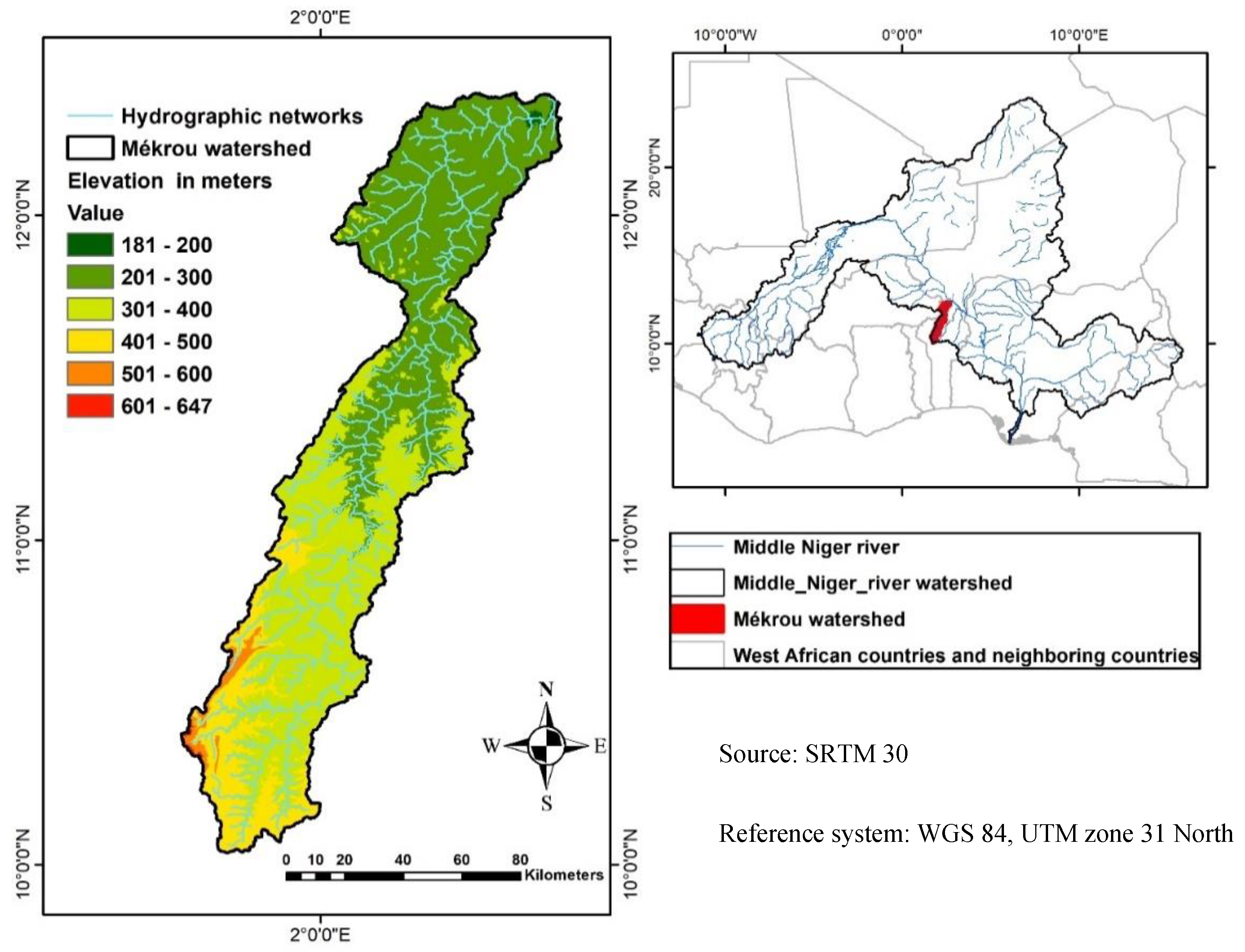
Figure 2.
Temporal evolution of the erosivity factor (R) in the Mékrou watershed.
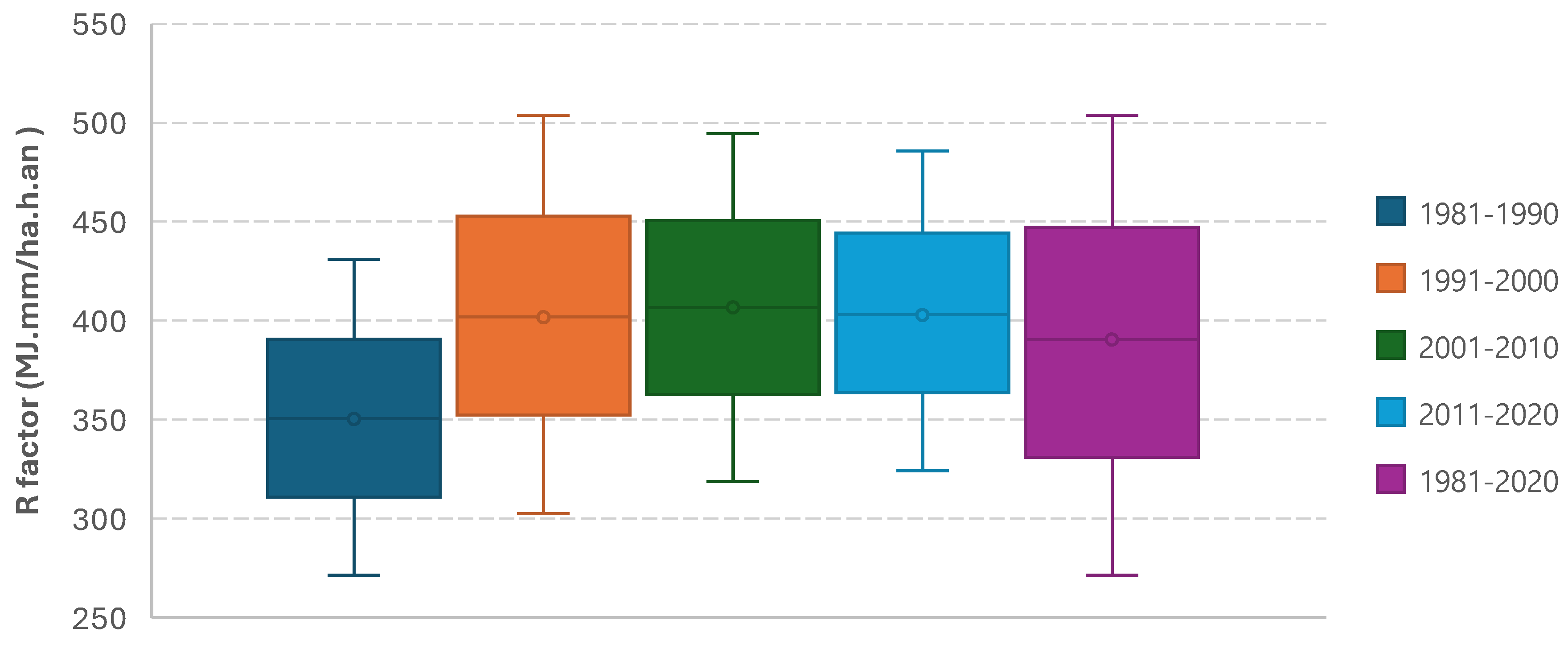
Figure 3.
Spatial distribution of water erosion factors (R, K, LS, C and P) in the Mékrou basin.
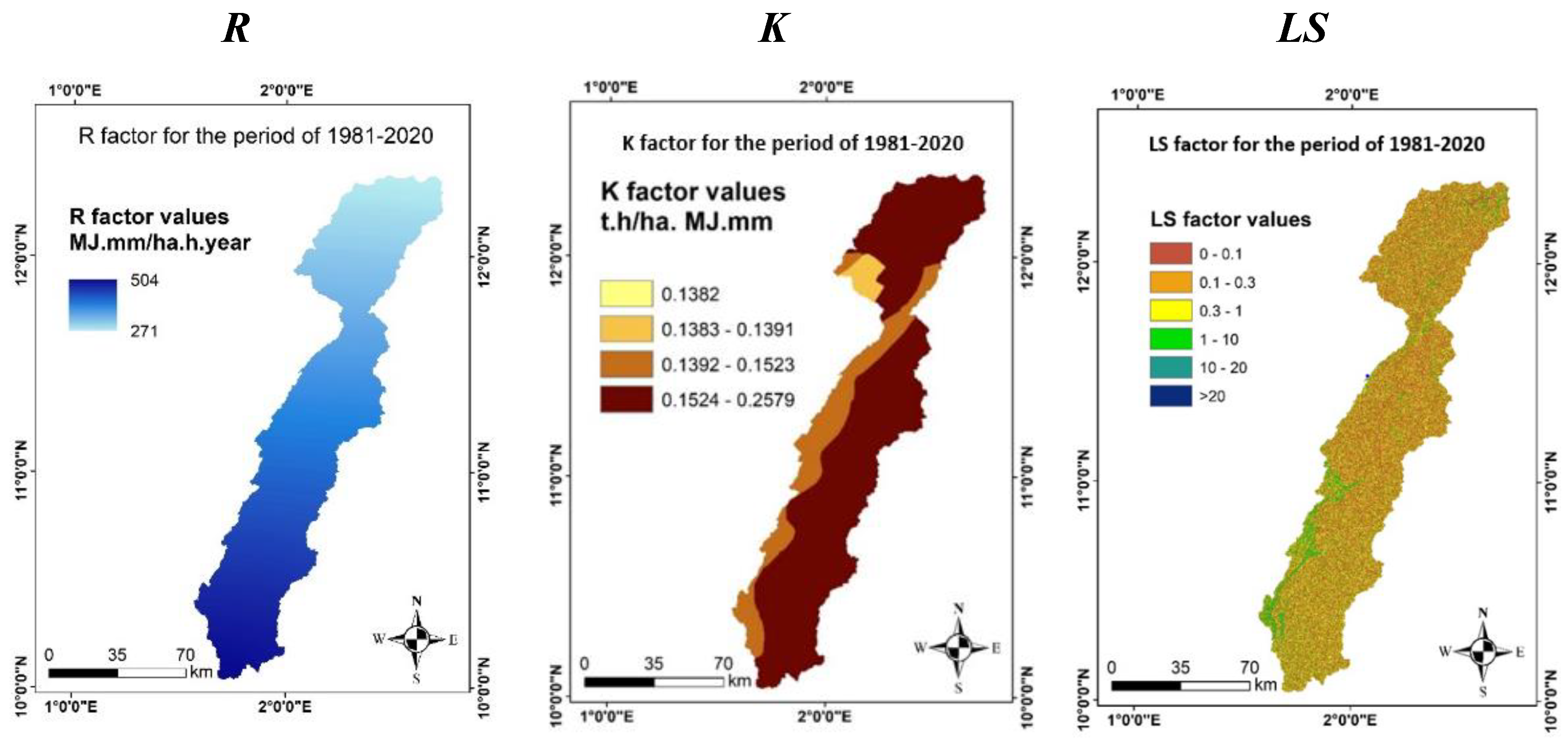
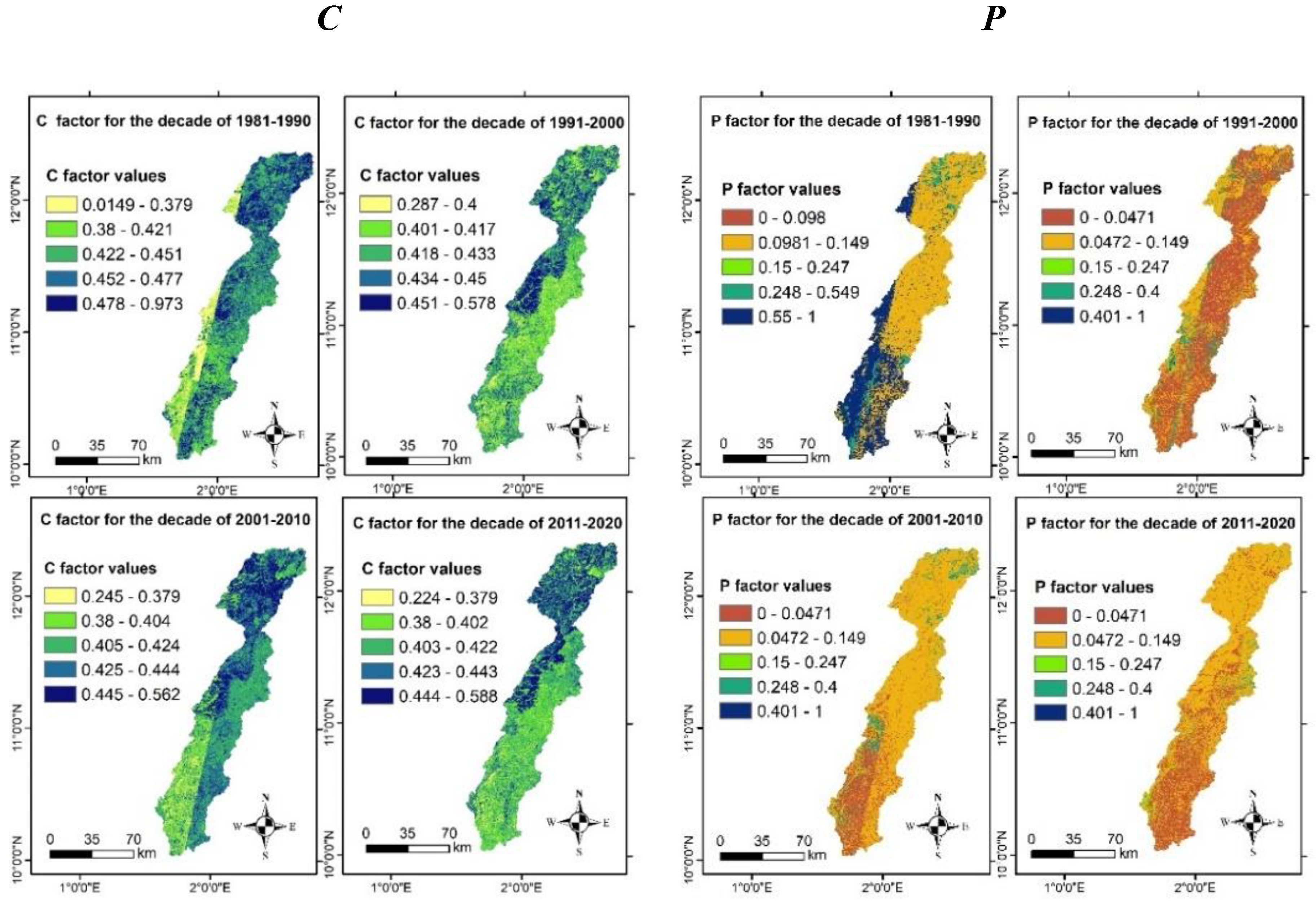
Figure 4.
Temporal dynamics of water erosion at decadal intervals within the Mékrou watershed.
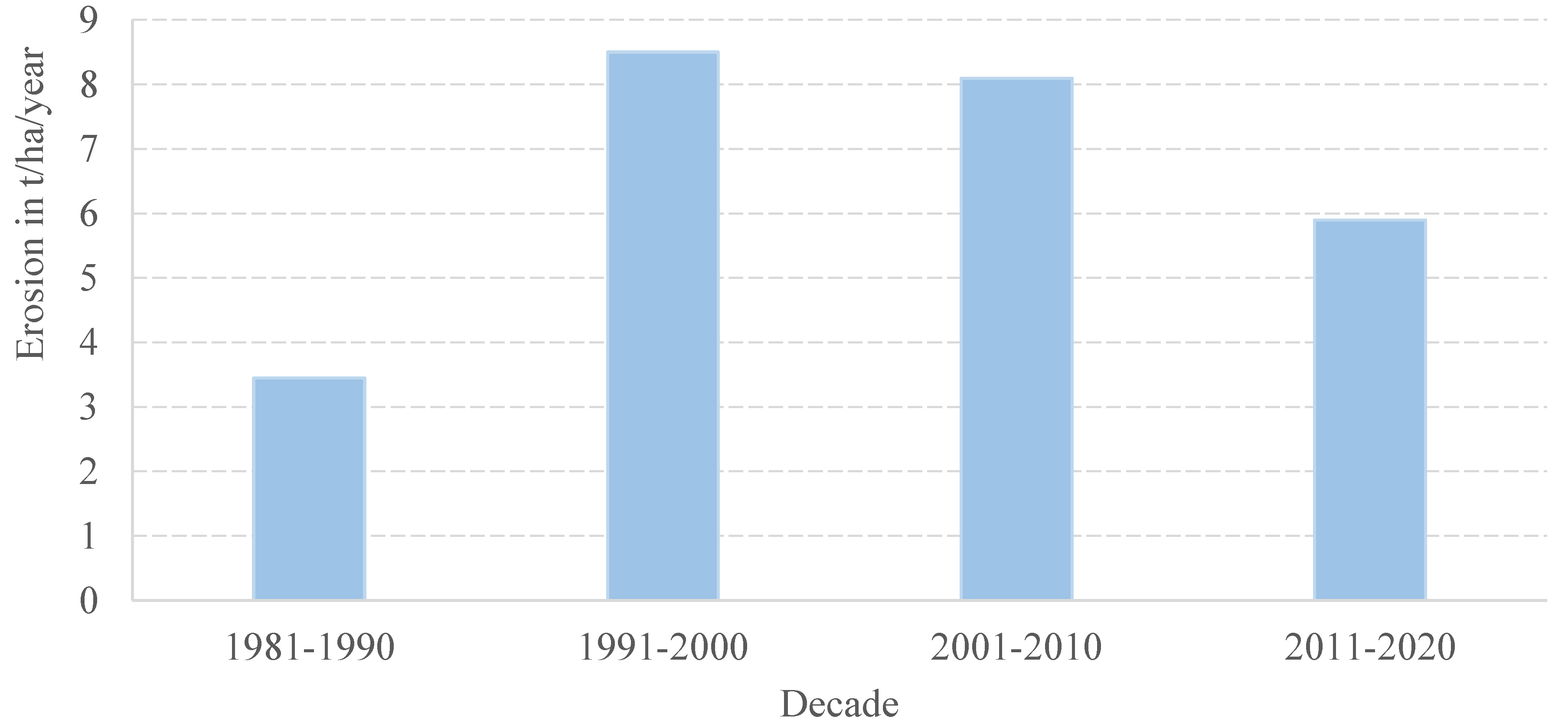
Figure 5.
Spatiotemporal dynamics of water erosion within the Mékrou watershed.
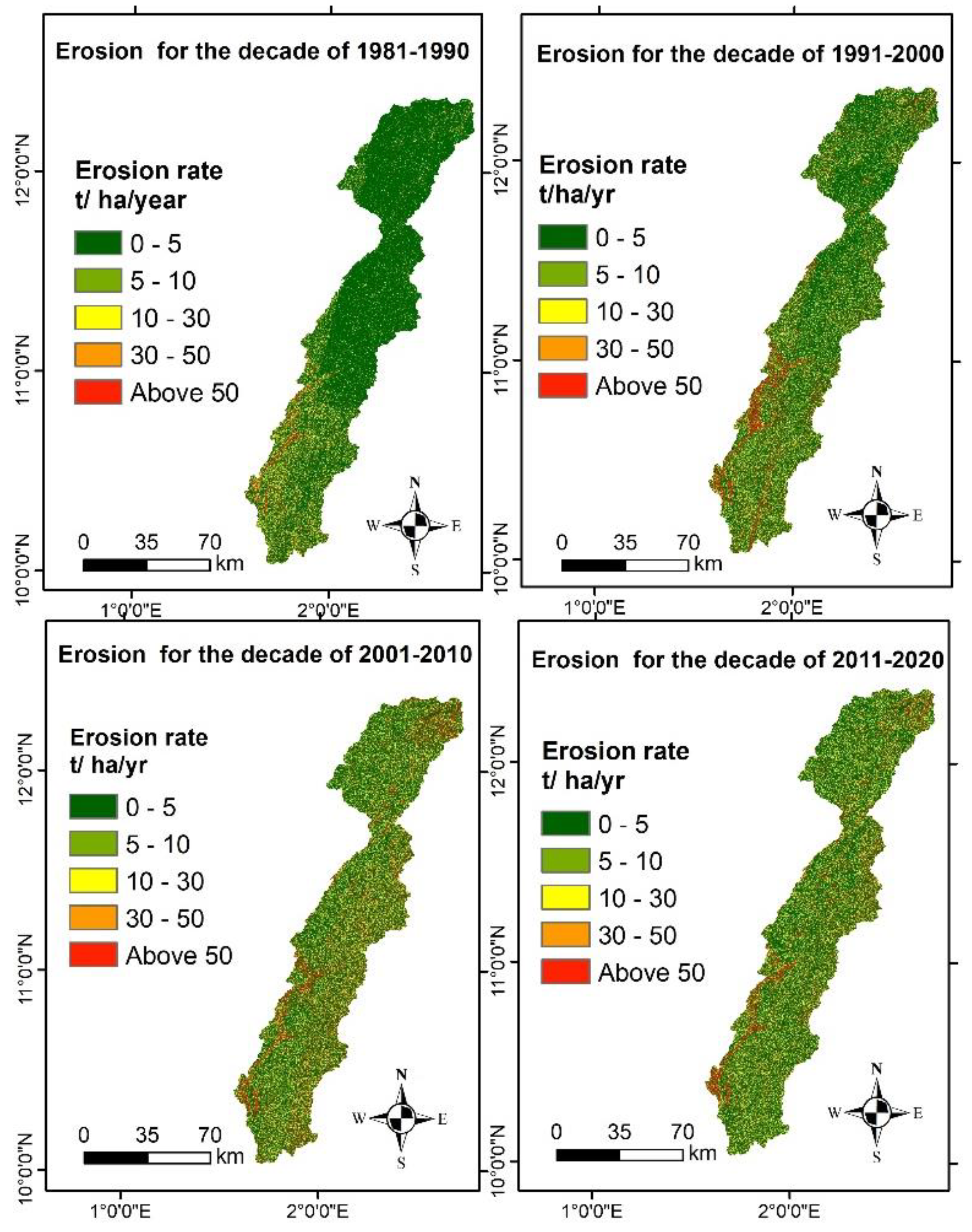

Table 1.
Soil classification and properties in the Mékrou watershed.
| Soil type | FAO code | Proportions in soil composition (%) | |||
|---|---|---|---|---|---|
| ms | msilt | mc | orgC | ||
| Eutric Gleysols | RE | 68.3 | 15.1 | 16.6 | 0.50 |
| Ferric Luvisols | LF | 74.6 | 09.6 | 15.8 | 0.26 |
| LITHOSOLS | I | 58.9 | 16.2 | 24.9 | 0.97 |
| Gleyic Luvisols | LG | 59.9 | 13.4 | 26.7 | 0.73 |
(Source : FAO, 2007).
Table 2.
Values of the P factor as a function of slopes.
| Land use | Slope (%) | |||||||
| 0-5 | 5-10 | 10-20 | 20-30 | 30-50 | 50-100 | 0-100 | ||
| P factor | Agricultural land | 0.10 | 0.12 | 0.14 | 0.19 | 0.25 | 0.70 | |
| Rangeland | 0.10 | 0.13 | 0.15 | 0.20 | 0.40 | 0.75 | ||
| Bare soil | 0.25 | 0.35 | 0.45 | 0.55 | 0.75 | 1.00 | ||
| Forest | 0.03 | 0.05 | 0.10 | 0.15 | 0.20 | 0.60 | ||
| Water | 0.00 | |||||||
| Urban land | 0.05 | |||||||
Table 3.
Results of K-factor estimates for the Mékrou watershed.
| Soil types | FAO code | K factor | |
|---|---|---|---|
| value in t.ha.h/ha.MJ.mm | Area in km² (% rate) | ||
| Ferric Luvisols | LF | 0.2579 | 6,655.2 (63.9) |
| Eutric Gleysols | RE | 0.1523 | 1,529.7 (14.7) |
| LITHOSOLS | I | 0.1394 | 1,921.3 (18.5) |
| Gleyic Luvisols | LG | 0.1382 | 298.1 (02.9) |
Table 4.
Water erosion statistics by class and decade.
| Class (t/ha/yr) | wa (1981-2020) (km²) |
Occupancy rate of the watershed (%) | ||||
|---|---|---|---|---|---|---|
| 1981-2020 | 1981-1990 | 1991-2000 | 2001-2010 | 2011-2020 | ||
| C1 : Very low (0-5) | 6,712.125 | 63.9 | 78.7 | 62.7 | 56.1 | 58.2 |
| C2 : Low (5-10) | 918.750 | 8.8 | 07.0 | 10.3 | 08.3 | 09.4 |
| C1 : Moderate (10-30) | 1,567.125 | 14.9 | 09.1 | 14.7 | 18.1 | 17.8 |
| C1 : High (30-50) | 525.000 | 5.0 | 02.4 | 04.5 | 07.0 | 06.1 |
| C1 : Very high (> 50) | 777.000 | 7.4 | 02.8 | 07.8 | 10.5 | 08.5 |
Signification : wa - watershed area.
Disclaimer/Publisher’s Note: The statements, opinions and data contained in all publications are solely those of the individual author(s) and contributor(s) and not of MDPI and/or the editor(s). MDPI and/or the editor(s) disclaim responsibility for any injury to people or property resulting from any ideas, methods, instructions or products referred to in the content. |
© 2024 by the authors. Licensee MDPI, Basel, Switzerland. This article is an open access article distributed under the terms and conditions of the Creative Commons Attribution (CC BY) license (http://creativecommons.org/licenses/by/4.0/).
Copyright: This open access article is published under a Creative Commons CC BY 4.0 license, which permit the free download, distribution, and reuse, provided that the author and preprint are cited in any reuse.


