
Submitted:
02 October 2024
Posted:
04 October 2024
You are already at the latest version
Abstract
Starting from the objectives of the Nature Restoration Law and the concept of Forest Landscape Restoration, the objective of the following study is to present a methodological approach aimed at identifying areas that are best suited for the implementation of NbS for the improvement of landscape and habitat status in the study area identified by the Urban Atlas of the city of Campobasso (1028.64 km2). Using open data (ISPRA ecosystem services and Regional land use capability), an expert based approach (questionnaire) and a multi-criteria analysis (AHP), the Total Ecosystem Services Value (TESV) index was determined as a weighted additive sum of the criteria (Data) considered. The index was then classified into 8 clusters and the land use “Cropland” was extracted, matching Cluster 1 (740.09 Ha) with agricultural areas with less ES provision to be allocated to NbS and Cluster 8 (482.88 Ha) with valuable areas to be preserved, for a total of 2.34% of the study area. It was then possible to compare the “Forest” areas currently present in the study area with those of a possible future scenario, represented by the areas occupied today by forest with the addition of cluster 1 croplands. A landscape analysis was then conducted: it showed greater dispersion and fragmentation of forest patches in the future scenario but also greater connectivity and thus greater ecological functionality of the patches.
Keywords:
forest
; multi-criteria analysis
; Urban Atlas
; Nature-based Solutions
; croplands
; ecosystem services
; landscape analysis
1. Introduction
Urbanization is proceeding at an extremely fast pace: for the first time since 2008, more than half of the world’s population lives within cities [1], and it is estimated that this will affect 66% of 9.8 billion people by 2050, mainly due to the social and economic process that has progressively resulted in the abandonment of rural, hilly, and mountainous areas [2], and the consequent process of urbanization. As a result, built-up land is expanding, while surrounding natural environments and green areas within urban areas are threatened [3]. In fact, urban sprawl has a substantial ecological footprint and is a driver of land use change [4]. Although cities occupy only 2% of the earth’s surface, people are already using 75% of all natural resources [1]. This implies the configuration of available urban green spaces as central elements in increasing the quality of urban settings and local resilience, resulting in positive impacts on people’s health and well-being [5].
It’s important to develop a network of green infrastructure, not just ancillary green, so that it can cope with the high complexity and dynamism of urban areas [6]. Another fundamental thing, at the planning level, are the structure and choice of areas to be allocated to green spaces as well as their type. In general, different types of green spaces should be planned, giving importance to biodiversity and favoring the use of native species [5]. It is necessary for green infrastructures to be well planned as they can contribute differently to the provision of ecosystem services (ES), depending on the vegetation types and different types of green spaces and corridors (e.g., urban trees and rows), patches (e.g., isolated trees), and matrices (e.g., urban and peri-urban forests) [7]. Urban and Peri-urban Forests (UPFs) provide multiple ES; in particular, they mitigate the microclimate and reduce pollution through pollutant sequestration, promote carbon storage, and are crucial for erosion control [8]; in addition, they are important as habitats for rare animal and plant species, as well as for biodiversity and pollination [3]. In some contexts, their role is also relevant in providing citizens with provisioning services such as nuts, berries, mushrooms, herbs and game [9]. In addition, there are numerous physical and psychological benefits associated with green spaces; they improve mental health and well-being [10], reduce stress caused by modern lifestyles [11], and may have lasting psychological benefits [12]; benefits related to longevity have also been found [13]. Promoting UPFs by securing the ES produced by them is absolutely important for human well-being and future generations; however, UPFs are threatened by accelerated urbanization, deforestation and climate change, which also affects their ability to provide ES [14]. In addition, according to recent estimates [15], between 60 and 70% of EU soils are unhealthy, being subject to erosion, compaction, organic matter reduction, pollution, biodiversity loss, salinization, and sealing. When soils are healthy, they are able to provide provisioning, regulating, supporting and cultural services, e.g., EU croplands and grasslands produce ES amounting to €76 billion per year, of which only one-third is directly related to agricultural production [15].
According to the Report on Land Consumption, Spatial Dynamics and Ecosystem Services by SNPA (National Service for Environmental Protection), land consumption affects an average of 19 hectares per day in Italy, with a cemented surface area of about 21,500 km². This phenomenon is mainly due to urban expansion which, by making the soil impermeable, results in a greater susceptibility to flooding, increases heat waves, and leads to a loss of biodiversity, green areas, and ES, with a damage of 8 billion euros per year [16]. Focusing on Nature-based Solutions (NbS), thus increasing green infrastructures, could lead to the improvement of ecosystem health by reconnecting fragmented natural and semi-natural environments and restoring damaged habitats so that they can provide more goods and services [17].
The term Nature-based Solutions first appeared in the early 2000s, primarily in the context of solving agricultural issues, such as the use of habitats to mitigate farm effluent [18], later giving great emphasis to NbS to major contemporary societal challenges, such as climate [19]. It is an umbrella concept that encompasses a range of ecosystem-related terms and approaches that address societal challenges [20]. This concept represents a set of environmentally friendly alternatives that support the provision and maintenance of ES, and it integrates into other concepts, such as those of green and blue infrastructure, urban forestry, ecological engineering, etc. The strength of NbS lies in providing co-benefits and generating advantageous solutions (e.g., multifunctionality) [21]. According to the European Commission, an action can be addressed as NbS if it uses nature or natural processes, if it enhances or provides social, economic, and environmental benefits, and if it has a net benefit on biodiversity ([22]), such as vertical forests in urban settings [23]. The accumulated knowledge on NbS demonstrates that they are locally attuned solutions to the social context, and that they generate multiple benefits [24]; their use could make it possible to address both climate change and biodiversity loss, while also supporting various sustainable development goals [25]. In this regard, governmental and nongovernmental organizations are providing funds globally to implement NbS [26], with main focus especially on reforestation and afforestation programs [27] such as the EU’s “Three billion trees” [28] and the “Great Green Wall” [29]. Sustainable and successful NbS must deliver benefits for biodiversity and people [30]: trade-offs and synergies play a key role in NbS design [20].
Due to pressure from rapid urbanization and increased vulnerability to risks associated with climate change in cities around the world, NbS are increasingly being promoted and integrated into urban plans [31]: climate change is affecting European ecosystems and human well-being, and it is estimated that there will soon be even greater threats related to ecosystems and the socioeconomic system [32]. NbS are increasingly seen as central elements to various areas, due to their efficiency in coping with climate change-related extreme events through mitigation and adaptation actions, preserving human health and psychosocial well-being, improving air quality, and increasing landscape connectivity [21]. A limitation, however, is land availability, which is a barrier to implementing NbS within cities [31]. Another limitation is associated with the fact that policy instruments for the implementation of NbS are mostly related to the municipal sphere, and not at the landscape or higher levels, which would instead allow the multifunctionality of NbS to be enhanced [33]. To make NbS efficient, they require integrated, cross-sectoral planning and governance strategies for their integration and deployment [34], as well as the involvement of numerous stakeholders. Despite their widespread deployment in cities, there are still numerous challenges related to NbS, including lack of information about their benefits, uncertainties about how best to plan, design, implement, and manage them, as well as the inadequacy of existing planning systems [35].
Based on that, the aim of the study was to establish a methodology to identify degraded agricultural areas for restoration through NbS interventions. The areas were identified from the level of ES provision, obtained through an expert-based approach.
2. Materials and Methods
2.1. Study Area
The study area is represented by 38 municipalities in the Province of Campobasso, identified by the Urban Atlas [36] of the Province of Campobasso, in the Molise Region, Italy, which is also part of the study area of the PNRR National Biodiversity Future Center Project.
This choice was motivated by the desire to analyze the territorial system and the green infrastructure from a broader perspective than the mere administrative boundaries of the single city (Campobasso), which acts as a hub, in line with the political and planning guidelines of recent years.
The study area is 1028.64 km2, the minimum altitude is 148 m above sea level (Municipality of Macchia Valfortore), while the maximum altitude is 1086 m above sea level (Municipality of Cercemaggiore). From a landscape point of view, according to the ISPRA Map of Types and Physiographic Units of Landscape of Italy [37], the study area is classified as Terrigenous Hills Units, consisting of terrigenous lithologies, with more or less contrasted morphology, and Terrigenous Mountains Units in which the mountainous reliefs are characterized by terrigenous lithologies consisting of marls, clays and sands. The high erodibility of these lithologies, along with the tendency for the drainage network to deepen, contributes to the modest elevation of the reliefs, which are prone to landslides and water erosion.
The 2018 ISPRA National Land Cover Map [38] with a spatial resolution of 10 m was used to characterize land use and land cover. The map was obtained through the integration of data from the Copernicus Program’s Land Monitoring Service with ISPRA’s Land Use data. The choice of the data referring to 2018 was dictated by the fact that the most recent ES data, used for the computations, are available for 2018 only. The study area has a strong agricultural vocation, mainly represented by arable land; in fact, these areas characterize about 63% of the territory, followed by forests that occupy 25%, non-agricultural meadows that occupy just over 6%, and artificial surfaces that occupy just under 5% of the territory, respectively.
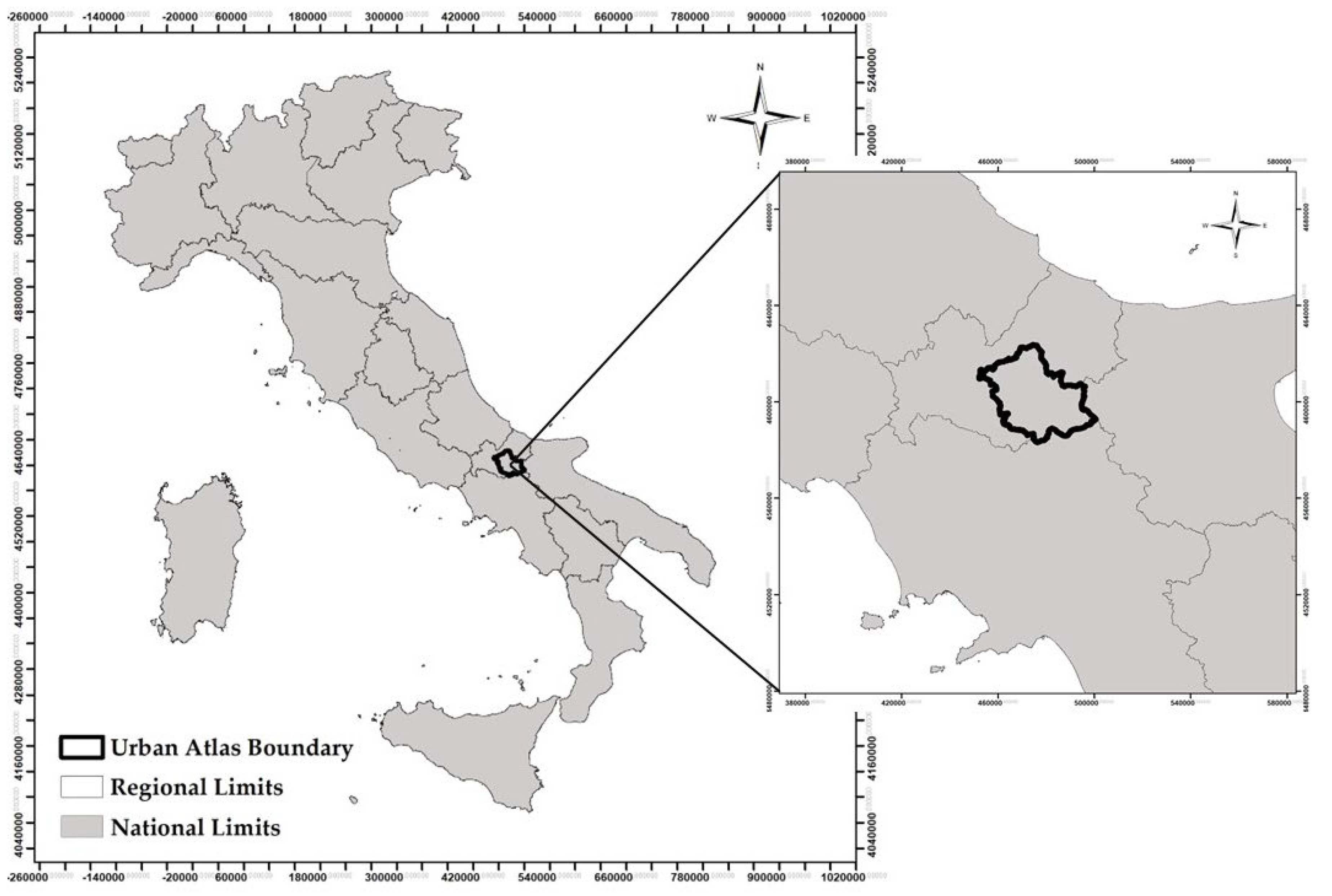
Figure 1.
Study area.
The methodology is based on the use of a series of available map layers related to ES delivery to develop a model, extendable to a national scale and replicable in other case studies, for the identification of areas characterized by low ES provision or situation of ecological degradation where environmental restoration interventions are needed. Interest fell on agricultural areas, especially “Croplands” which occupy 50.83% of the entire area, to identify “valuable” areas, characterized by high ES provision and adequate land capability, and those “degraded” to restore through NbS interventions. Through Landscape Ecology analysis, a comparison was also made in terms of ecological connectivity and functionality, carrying out a comparison between the current ecological network arrangement present in the study area and a hypothetical scenario in which the areas identified by the above model are subject to NbS interventions.
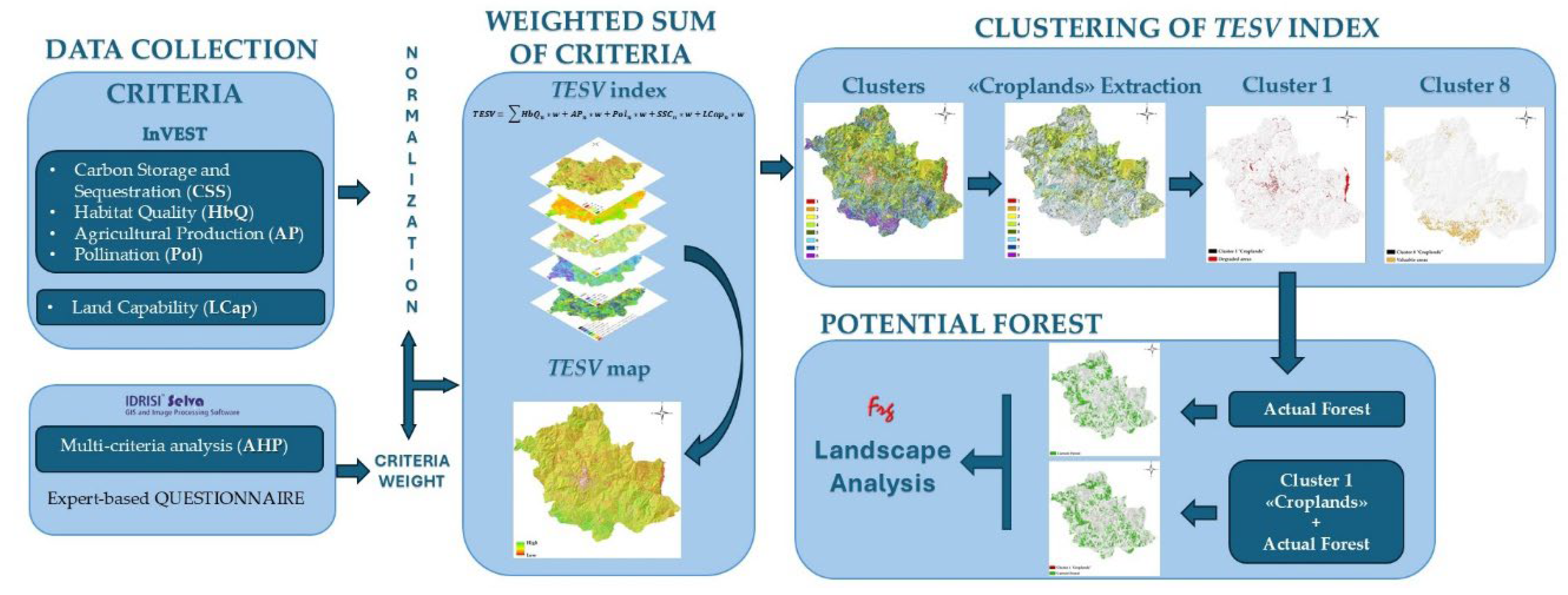
Figure 2.
Study workflow.
2.2. Assessment of Ecosystem Services Provided in the Study Area
The ES maps used were created with the InVEST (Integrated Valuation of Ecosystem Services and Tradeoffs, provided by the Natural Capital Project) [39] suite of models, which provide biophysical and economic analysis of the ESs delivered by the area. The software consists of several independent packages to evaluate 17 ESs belonging to all 4 ES categories of the Millennium Ecosystem Assessment (MEA) [40]. The model associates each land use class with a value of ES delivery. What ensures quality and accuracy of the outputs is the ability to take advantage of accurate inputs on land use and land biophysical characteristics, which are then used by the model to calculate ES delivery in biophysical and, therefore, economic terms [41,42]. The cartography derived from the integration of High-Resolution Layers [43], Corine Land Cover and the 2012 [44] national land use map was used to apply the models [42].
The 4 ESs examined are carbon storage and sequestration, habitat quality, agricultural production and pollination.
2.2.1. Carbon Storage and Sequestration (CSS)
Carbon sequestration and storage is a regulating service; all terrestrial ecosystems contribute to providing this ES, but to varying degrees: in general, it can be said that the more natural the ecosystem, the greater its capacity to store and sequester carbon. Natural and semi-natural environments have the highest potential for sequestration and storage (Sallustio et al., 2015). The estimation of this service in biophysical terms is done by spatializing the tons of carbon stored for each land use type [42].
2.2.2. Habitat Quality (HbQ)
Habitat quality belongs to supporting services; in fact, it is used as a proxy for assessing the state of land biodiversity [45]. Due to multiple pressures, such as land use change, sealing, urbanization, etc., habitats are subject to degradation and alteration, ecosystem fragmentation, and reduced ecological resilience. The InVEST model outputs a dimensionless index of quality ranging from 0 to 1; this index expresses values that are not absolute values of quality, but rather relative to the environmental conditions of the study area: the value associated with each individual unit is derived from the relationship between it and neighboring units [42].
2.2.3. Agricultural Production (AP)
Agricultural production is part of provisioning services, an important service when related to the many areas used for productive purposes in agriculture. This service is influenced by climatic-stational factors: latitude, climate, exposure, slope, altitude, etc., and by the type of use, whether intensive or extensive. Soil consumption, in the context of agricultural production, leads to loss of the service, in the present and in the future, since soil is a nonrenewable resource [45]. For the assessment of this ES, the Average Agricultural Values were used, divided and spatialized for each agrarian region [42]. The study area is characterized by 4 of the 7 agrarian regions of Molise (1, 2, 4 and 6 agrarian regions) [46].
2.2.4. Pollination (Pol)
Pollination is a very important regulating service; it is provided by pollinating animal organisms, such as bees and bumblebees, and by agents such as wind and water. This service is provided depending on the availability of nesting habitat and floral resources, climate, and the foraging distance of pollinators, that is the distance that must be traveled to get to nectar and pollen sources. Again, the InVEST model outputs a dimensionless Pollination Index ranging from 0 to 1, depending on the suitability of a given portion of land to host pollinators [47].
For more details on the InVEST model and the mapping used, see ISPRA [42].
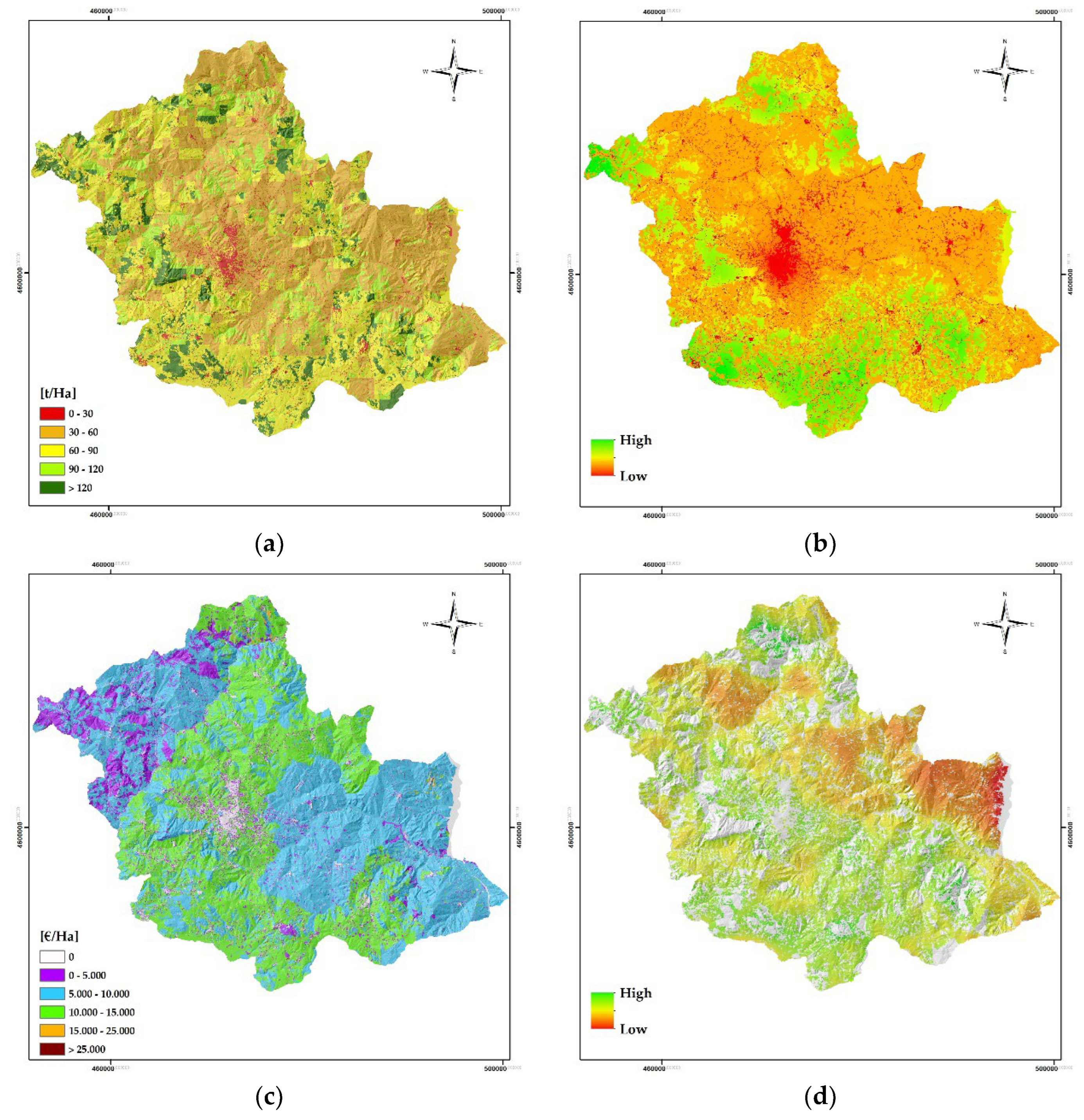
Figure 3.
InVEST maps. (a) CSS; (b) HbQ; (c) AP; (d) Pol.
2.3. Land Capability (LCap)
Land capability, also referred to as “natural use,” is an indispensable element in land use planning and development policies. Indeed, land use that deviates greatly from its natural use causes severe impacts to the environment, including soil erosion and reduced fertility (Araújo Costa et al., 2019). The land capability classification was developed by the U.S. Department of Soil Conservation Service; it is useful for assessing the distribution of constraints, including slope, erosion risk, climatic conditions, and soil depth, that create restrictions in, for example, agriculture. Eight classes have been defined: the first four, with different propensities, are found to be appropriate for agricultural activity, while the latter have more restrictions.
For further discussion, see Klingebiel A. & Montgomery [48].
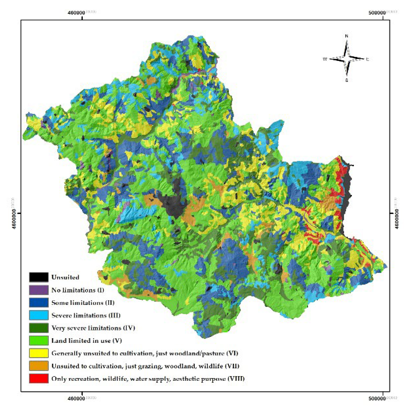
Figure 4.
Land capability in study area.
2.4. Normalization of Criteria
Since the information used was totally heterogeneous, in terms of data types and units of measurement, it was necessary to harmonize it, through normalization, in order to make it comparable and usable by the model.
For the CSS, HbQ, Pol and AP services, normalization was performed on the minimum and maximum values, i.e., by setting the minimum value of the service in the study area to 0 and the maximum value to 1 and scaling the intermediate values linearly again.
As for the normalization of LCap, however, 0 corresponds to built-up areas, which have no propensity for agricultural use, while 1, corresponds to areas with little or no restrictions, and therefore with better propensity for agricultural use.
2.5. Multi-Criteria Analysis for The Assessment of Ecosystem Services and Identification of Valuable and Degraded Areas
The approach used to identify areas for NbS is the one based on multi-criteria analysis (MCA). MCA represents an umbrella concept that encompasses within it more than a hundred methods, which evaluate an object by considering different dimensions of interest and the interactions between multiple, often conflicting objectives and different decision criteria and metrics. The performance of an option against the various objectives and criteria, which can be assigned different weights, in this case from 0 to 1, are identified by scores. Higher scores are associated with higher performance [49].
The Analytic Hierarchy Process (AHP) method, developed by Thomas L. Saaty between 1971 and 1975 and later improved and integrated within spatially explicit models and tools (e.g., GIS), was chosen. The method organizes information by having different criteria interacting in different ways (alternatives) so that they are able to reflect their relative importance to the objective at hand [50]. The criteria used for the analysis model were the four ESs and the LCap.
In order to give weight to each of the five criteria, an expert-based approach was followed by administering a questionnaire to 19 experts in academia from the following disciplinary fields: Forestry, Environmental Sciences, Biological Sciences, Economics and Natural Sciences. This questionnaire was structured to compare all criteria with each other in pairs, assigning a relative weight based on 5 options:
- Equally important (1);
- Moderately more important (3);
- Strongly more important (5);
- Clearly more important (7);
- Extremely more important (9).
16 out of 19 experts answered to the questionnaire; each questionnaire was subsequently analyzed using the Weight Tool of IDRISI Selva software to determine the relative weight, assigned by each expert, to each criteria considered.
The software, in output, provides the relative weight of the criteria associated with each questionnaire and the Consistency Ratio (CR). The CR is a measure of the consistency of the judgment matrix. According to Saaty, the CR is acceptable if its value is less than 10% (between 0 and 0.10, therefore); however, a value of up to 20% (<0.20) is also considered tolerable [51]. Of the 16 CR values, 6 are out of considered range acceptable/tolerable; therefore, they were not examined, as they were not consistent according to the methodology adopted.
The relative values of the individual criteria defined by the questionnaires are shown in Table 1.
The final weights to be given to the 5 criteria are shown in Table 2 and are equal to the average of the relative weights given in Table 1. This sum must always be equal to 1.
For completeness, the standard deviation was also calculated for each criterion considered.
2.5.1. Weighted Sum of the Considered Criteria
Once all criteria were normalized, the weighted sum was performed using the weights previously obtained. The final index, the Total Ecosystem Services Value (TESV) [52] was then equal to:
where subscript n denotes the normalized 0-1 scale value of the individual ES while w denotes its relative weight obtained by the expert-based approach. The TESV values range from a minimum of 0 to a maximum of 1.
2.5.2. Clustering of TESV Index: K-Means for Grids
In order to clearly identify valuable and degraded areas, the TESV index was clustered using the K-means clustering algorithm “Hill-Climbing,” in the SAGA GIS environment.
According to the eight land capability classes, eight clusters were generated, with a distribution of increasing values from cluster 1 to cluster 8; cluster 1, i.e., the one characterized by lower ES provision and lower agricultural land use predisposition, was considered, from which the areas of “Cropland” were extracted in order to identify the areas to be targeted for NbS interventions.
2.6. Analysis of Changes in Terms of Landscape Fragmentation and Ecological Connectivity
2.6.1. Current Forest and Future Scenario
Once the arable land to be targeted for NbS interventions had been identified, starting from the current forest area map (current scenario), a hypothetical future scenario (potential) was created, in which the current forest area is added to the newly created areas related to the “Cropland” areas of Cluster 1. In order to assess the possible changes in terms of ecological connectivity and functionality in the two scenarios, maps of both the current and potential forest were produced. This analysis was conducted using Landscape Ecology techniques, the discipline that studies and implements the relationship between spatial pattern and ecological processes at multiple scales and organizational levels [53].
2.6.2. Landscape Metrics
The ecological connectivity and functionality analysis of the two scenarios was conducted using a set of class and landscape metrics referring to the land use class “Forest” by means of Fragstats 4.2 software [54].
The selected metrics are shown in Table 3.
3. Results
3.1. Processing of the Final Cartography (TESV Index)
Figure 5a shows the spatial distribution of the TESV index, which in the study area ranges from 0.046 to 0.823, with the average value around 0.451 and coefficient of variation of 19.06%. Almost 45% of the area is classified as intermediate clusters 4 and 5, the highest values are concentrated in the south, and particularly the southwest, and northwest, while the lowest values are in the east range.
Figure 5b shows the spatial distribution of the TESV index ranked in the 8 clusters identified.
3.2. Cartography of Valuable Areas
The cluster 8 was identified as those areas considered “valuable” due to TESV values between 0.597 and 0.823 (Figure 7b).
These areas cover an area of 4718.2 hectares, the 4.59% of study area, and are mainly located in the southwest. Only 10.23% of these areas (482.88 Ha) are “Croplands”, 9.5% of total valuable areas (448.23 Ha) are Natura2000 areas.
3.3. Cartography of Degraded Areas
The areas to be allocated for NbS are the most degraded of agricultural land use, and specifically cluster 1 of “Croplands” (Figure 7a), within representing 1.42% of the class (740.09 hectares), this portion are 0.72% of the entire study area.
22.62% (750.21 hectares) of “Arable land” in cluster 1 are Natura2000 areas.
3.4. Future Scenarios: Potential Forest
By transforming the Croplands of Cluster 1 into forests and adding them to the ‘Forest’ class, it was possible to obtain the map of potential forests, the situation that would occur if these agricultural areas were subject to NbS interventions (Figure 8). The current “Forest” covers an area of 25976.06 hectares, while the potential forest would have an area of 26718.36 hectares, with an increase of 2.86% over the baseline situation (+742.30 hectares).
In the current scenario, 18.20% of the “Forest” (4727.38 hectares) are Natura2000 areas; in the potential scenario, however, these increases of 49.38 hectares.
3.5. Analysis of Metrics
To investigate how connectivity and ecological functionality varies between the two scenarios, current forest and potential forest, class and landscape metrics were calculated using Fragstats software.
Below, in Table 6, there are the results obtained as outputs for the class metrics:
Analyzing the difference between current forest and potential forest (Table 6), it’s evident that Patch Density (PD) increases, in line with the addition of new patches from agricultural land. Same trend can be seen with the Landscape Similarity Index (LSI), as the increase in forest class patches automatically makes them less rare. The increase in Total Core Area (TCA) is interesting: this denotes an increase in patch contiguity and a reduction in fragmentation and edge effect. Euclidean Nearest Neighbor Distance (ENN_MN) decreases: this means that the distance between patches decreases as their number increases, even in areas initially lacking “Forest” land use class; this is confirmed by Euclidean Nearest Neighbor Distance (Area-Weighted Mean) (ENN_AM). The reduction in the Percentage of Similar Adjacencies (PLADJ) shows a reduction in patch density not due to a reduction in number but to a greater dispersion of patches, resulting in greater fragmentation of the forest due to the addition of new patches. In addition, the increase in Normalized Landscape Shape Index (NLSI) is indicative of greater class complexity and irregularity.
In Table 7 there are the results obtained as outputs for the landscape metrics:
The “landscape” metrics considered (Table 7) are in line with the considerations made above for the ‘class’ metrics. The Average Area (AREA_MN) increases due to the addition of new smaller forest patches. Also, the decrease in Mean Radius of Gyration (GYRATE_MN) represents a reduction in the dispersion of patches around their center of mass, hence greater connectivity. The increase in Number of Disjunct Core Area (NDCA) denotes the increase in core areas, i.e., the increase in portions of habitat that are far from the edge and not affected by the edge effect, supported by the increase in Disjunct Core Area Density (DCAD). The reduction in Aggregation Index (AI), moreover, tends to emphasize a lower aggregation of particles, mainly due to the increase of forest patches even in areas that were initially devoid, and consequently a greater dispersion of patches.
4. Discussion
4.1. Analysis Model
While developing the analysis model, it became early clear that there was a paucity of literature on the subject, not a lot for what concerns mapping ESs, which are widely covered and studied, but more for identifying areas characterized by poor ES delivery to be improved through NbS. Among the few examples of models found, it was decided to base this study on the one conducted by the working group of the University of Molise, in collaboration with ISPRA, on the Metropolitan City of Rome (MCR) [55], whose aim was the identification of agricultural areas of greater and lesser value. MCR model used 4 ESs (CSS, QHb, Imp and PA), then normalized and simply summed together. In this study, as well as adding the information related to LCap, which influences the capacity of ESs to be delivered, it was decided to include an expert-based approach to get the weight of individual criteria to finally define TESV index.
However, there are still some aspects to be improved, first of all the importance to expand the panel of experts to whom the questionnaires should be administered; the academic field was chosen to have the guarantee of the competence of the people surveyed, but it could be considered to administer it also to other stakeholders, such as policy makers but also environmental associations, experts in the field, in order to have a broader picture in the definition of this index.
Another limitation is related to the difficulty of finding information regarding the nature of ownership, public or private, of the identified areas. It would be useful to investigate in this regard to check the feasibility of projects aimed at improving the delivery of ES by minimizing the implications for private properties or by providing for public/private agreements aimed at improving the return for both [56].
The proposed model is easily replicable, even at the national scale; the availability of national data regarding the 4 ESs considered, made by ISPRA, would allow for a large-scale analysis. The only limitation might be the availability of a LCap map at the national scale: in fact, it has been verified that a good part of the Italian regions has such a map, but it is not immediately available for download. In the case, however, a geometric and thematic harmonization operation would be necessary due to the different scales of realization and the possible different classification systems adopted.
4.2. Distribution of Clusters
Looking at the distribution of the TESV index throughout the study area, it is possible to state that the most prevalent values are the average ones. In fact, the most represented clusters are Clusters 4, 5 and 6 (values between 0.403 and 0.529), with an average TESV of 0.451. In fact, the valuable areas (Cluster 8) together with those of lesser value (Custer 1) occupy less than 8 percent of the entire territory; if only agricultural areas are analyzed, out of the total of about 52274 hectares, the percentage of the territory occupied by Clusters 1 and 8 is 2.34 percent. Parallel to the need to take action on the rehabilitation of low TESV areas, the low presence of high value agricultural areas triggers considerations as to whether NbS should be used to increase them.
To analyze the location of degraded areas, a 60-m buffer was made around the urban land use of the ISPRA land use map (code 11000), in accordance with SNPA [16], to identify areas subject to influence by anthropogenic disturbances and to assess the percentage of degraded areas that fall within this buffer. Of the 3470.3 total hectares in Cluster 1, 70.61% fall within the buffer, while of the 740.09 hectares of arable land in the same Cluster, 86.18% (2990.7 Ha) fall within the buffer (Figure 9).
This is in line with the values of the HbQ service, which is also the ES given the highest relative weight by most experts, which is why it is also the most relevant following the averaging of relative weights in determining TESV. Indeed, as stated by Sallustio et al. [45], the quality and degradation of habitats are highly dependent on the distribution and intensity of anthropogenic impacts, and consequently also on the proximity of the disturbance, as well as on the suitability (suitability) of a given portion of land to host species and habitats. The impact on HbQ increases as the distance from the disturbance decreases. The fact that the areas of greatest degradation fall largely within the buffer is a significant finding: targeted interventions could, in fact, encourage, on the one hand, an increase in the quality of contiguous agricultural areas (e.g., through agroforestry facilities, which would increase the supply of ESs within the areas under consideration), but also prevent further land consumption due to unprofitable agricultural areas, which could be abandoned or built upon, which would further implement land consumption and the deterioration of the structural and functional characteristics of the landscape matrix as a whole.
4.3. Connectivity
Linear soil sealing (e.g., roads and highways) plays a real barrier effect to migratory routes and animal movements in general, thus resulting in a serious threat to biodiversity [57].
In this regard, Landscape Ecology’s analysis was useful in highlighting an increase in dispersion of the forest land use class, due, however, not to the fragmentation of existing patches, as they have not been reduced or converted to other land uses, but to the increase in number of small forest patches (“Croplands”, Cluster 1) within areas initially devoid of this land use. A further problem is that unfortunately in some agricultural landscapes these small forest patches are decreasing, even in Molise [58]. Another relevant thing is the increase in core areas as well as increased patch complexity and irregularity, highlighted respectively by the TCA and NLSI class metrics together with DCAD landscape metric. Although forest fragmentation and disaggregation increase, the ENN_MN and ENN_AM class metrics emphasize greater connectivity. In fact, the increase in the number of smaller patches decreases their spacing, which give the possibility to assume better connectivity at the landscape level, which is highlighted by the GYRATE_MN landscape metric. The newly added patches can be configured as true stepping stones, fostering connectivity and movement of species, and represent the starting point for the creation of continuous linear elements and green corridors, mainly close to the road network, also in line with the National Urban Green Strategy [2], whose purpose is to implement the Ecological Network at the national level, fostering connectivity between different areas (human, agricultural and natural).
4.4. Which NbS?
The choice of NbS to be used to improve the delivery of ES is mainly dictated by the characteristics and location of degraded areas. For rehabilitation and improvement of areas close to roads, one might consider investing mainly in green corridors or peri-urban forests. Much depends, however, on the type of ES to be enhanced, the available budget, and other policy-planning requirements.
Important in general is the planting of trees, either isolated or in groups, which are considered the best natural element to increase the spectrum of ES disbursed [21]; tree planting, in fact, would play a positive role in increasing connectivity and ecological restoration. Also not to be underestimated is the aesthetic perception of the landscape and how it might improve as a result of tree planting. The survey conducted by Di Cristofaro et al. [59], in fact, emphasized the aesthetic preference toward landscapes rich in out-of-forest trees in anthropized contexts, confirming the theory that the most common landscape preference is for increased exposure to nature, even more so if in highly built-up contexts.
Ultimately, the present experiment has highlighted the validity of the TESV index for identifying degraded areas and areas of value as a tool to support wide-area spatial planning, as a connecting element between guidelines and policies at the national scale and the detailed planning level at the municipal scale, in line with [55].
5. Conclusions
The MCA applied for the identification of agricultural areas for NbS interventions seemed suitable for achieving the outlined objective; it would be possible to implement and validate it in a way that would make it more effective and extendable to various realities, including at the national level. The provision of ES in urban and peri-urban areas, in fact, is an increasingly topical and relevant issue, considering that built-up land is expanding and this brings with it a number of future challenges; land consumption is increasingly impactful and, in order to improve the lives of citizens, as well as the quality of productive agricultural land, it is important to incentivize such provision. NbS could ultimately be the central aspect of achieving this goal, in a variety of forms.
Moreover, this methodology could be an excellent support at various levels of planning, first and foremost at the municipal level, where there is often a shortage of funds to conduct ground surveys, in order to direct management policies and implement the structure of ecological networks at the national level, reducing fragmentation and fostering greater connectivity between urban, agricultural and natural areas, and improving the delivery of a multitude of ES, including cultural.
Author Contributions
Conceptualization, B.P., M.O. and L.S.; methodology, M.O. and L.S; software, M.O. and B.P.; validation, L.S.; formal analysis, B.P.; investigation, M.O. and B.P.; resources, M.O. and L.S.; data curation, M.O.; writing—original draft preparation, M.O.; writing—review and editing, B.P., and L.S.; supervision, M.O. All authors have read and agreed to the published version of the manuscript.
Funding
This research received no external funding.
Data Availability Statement
The data that support the findings of this study are available from the corresponding author upon reasonable request and approval fromthe study sites representative coauthors.
Acknowledgments
For administrative and technical support the authors are grateful to National Biodiversity Future Center (NBFC), project funded under the National Recovery and Resilience Plan (NRRP), Mission 4 Component 2 Investment 1.4 - Call for tender No. 3138 of 16 December 2021, rectified by Decree n.3175 of 18 December 2021 of Italian Ministry of University and Research funded by the European Union – NextGenerationEU; Award Number: Project code CN_00000033, Concession Decree No. 1034 of 17 June 2022 adopted by the Italian Ministry of University and Research, CUP H73C22000300001, Project title “National Biodiversity Future Center - NBFC”.
Conflicts of Interest
The authors declare no conflict of interest.
References
- Salbitano, F.; Borelli, S.; Conigliaro, M.; Chen, Y.; Food and Agriculture Organization of the United Nations Guidelines on Urban and Peri-Urban Forestry; FAO, 2016; ISBN 9789251094426.
- Atelli, M.; Blasi, C.; Boldini, G.; Cignini, B.; Cosenza, G.; Emiliani, V.; Marchetti, M.; Maria Maggiore, A.; Pericoli, T.; Ricciardi, A.; et al. Strategia Nazionale Del Verde Urbano (Comitato Del Verde Pubblico); 2018;
- Baumeister, C.F.; Gerstenberg, T.; Plieninger, T.; Schraml, U. Exploring Cultural Ecosystem Service Hotspots: Linking Multiple Urban Forest Features with Public Participation Mapping Data. Urban For Urban Green 2020, 48, doi:10.1016/j.ufug.2019.126561. [CrossRef]
- Churkina, G. Modeling the Carbon Cycle of Urban Systems. Ecol Modell 2008, 216, 107–113, doi:10.1016/j.ecolmodel.2008.03.006. [CrossRef]
- World Health Organization. Regional Office for Europe Urban Green Spaces: A Brief for Action; 2017;
- Fusaro, L.; Salvatori, E.; Mereu, S.; Marando, F.; Scassellati, E.; Abbate, G.; Manes, F. Urban and Peri-Urban Forests in the Metropolitan Area of Rome: Ecophysiological Response of Quercus Ilex L. in Two Green Infrastructures in an Ecosystem Services Perspective. Urban For Urban Green 2015, 14, 1147–1156, doi:10.1016/j.ufug.2015.10.013. [CrossRef]
- Gilli; Handley; Ennos Adapting Cities for Climate Change: The Role of the Green Infrastructure. 2007.
- Pulighe, G.; Fava, F.; Lupia, F. Insights and Opportunities from Mapping Ecosystem Services of Urban Green Spaces and Potentials in Planning. Ecosyst Serv 2016, 22, 1–10, doi:10.1016/j.ecoser.2016.09.004. [CrossRef]
- Poe, M.R.; LeCompte, J.; McLain, R.; Hurley, P. Urban Foraging and the Relational Ecologies of Belonging. Soc Cult Geogr 2014, 15, 901–919, doi:10.1080/14649365.2014.908232. [CrossRef]
- Lee, A.C.K.; Maheswaran, R. The Health Benefits of Urban Green Spaces: A Review of the Evidence. J Public Health (Bangkok) 2011, 33, 212–222.
- Campagnaro, T.; Vecchiato, D.; Arnberger, A.; Celegato, R.; Da Re, R.; Rizzetto, R.; Semenzato, P.; Sitzia, T.; Tempesta, T.; Cattaneo, D. General, Stress Relief and Perceived Safety Preferences for Green Spaces in the Historic City of Padua (Italy). Urban For Urban Green 2020, 52, doi:10.1016/j.ufug.2020.126695. [CrossRef]
- Sacker, A.; Cable, N. Do Adolescent Leisure-Time Physical Activities Foster Health and Well-Being in Adulthood? Evidence from Two British Birth Cohorts. Eur J Public Health 2006, 16, 331–335, doi:10.1093/eurpub/cki189. [CrossRef]
- Takano, T.; Nakamura, K.; Watanabe, M. Urban Residential Environments and Senior Citizens’ Longevity in Megacity Areas: The Importance of Walkable Green Spaces. J Epidemiol Community Health (1978) 2002, 56, 913–918, doi:10.1136/jech.56.12.913. [CrossRef]
- Cueva, J.; Yakouchenkova, I.A.; Fröhlich, K.; Dermann, A.F.; Dermann, F.; Köhler, M.; Grossmann, J.; Meier, W.; Bauhus, J.; Schröder, D.; et al. Synergies and Trade-Offs in Ecosystem Services from Urban and Peri-urban Forests and Their Implication to Sustainable City Design and Planning. Sustain Cities Soc 2022, 82, doi:10.1016/j.scs.2022.103903. [CrossRef]
- ISPRA; SNPA Consumo Di Suolo, Dinamiche Territoriali e Servizi Ecosistemici Munafò Michele. ISPRA Istituto Superiore per La Protezione e La Ricerca Ambientale Consumo Di Suolo, Dinamiche Territoriali e Servizi Ecosistemici Edizione 2021 Rapporto ISPRA SNPA; 2022; ISBN 9788844811242.
- SNPA Consumo Di Suolo, Dinamiche Territoriali e Servizi Ecosistemici; 2022;
- European Union Building a Green Infrastructure for Europe; Publ. Office of the European Union, 2013; ISBN 9789279334283.
- Potschin, M.; Haines-Young, R.H. Nature-Based Solutions ESMERALDA-Enhancing Ecosystem Services Mapping for Policy and Decision Making View Project; 2015;
- Eisenberg, B. Nature Based Solutions-Technical Handbook INTERESS-I: Integrierte Strategien Zur Stärkung Urbaner Blau-Grüner Infrastrukturen View Project Space Syntax and Open Space Planning View Project. 2019, doi:10.13140/RG.2.2.24970.54726. [CrossRef]
- Price, R. Nature-Based Solutions (NbS)-What Are They and What Are the Barriers and Enablers to Their Use?; 2021;
- Di Pirro, E.; Sallustio, L.; Castellar, J.A.C.; Sgrigna, G.; Marchetti, M.; Lasserre, B. Facing Multiple Environmental Challenges through Maximizing the Co-Benefits of Nature-Based Solutions at a National Scale in Italy. Forests 2022, 13, doi:10.3390/f13040548. [CrossRef]
- European Commission FUTURE BRIEF: The Solution Is in Nature – Issue 24.
- Sowińska-Świerkosz, B.; García, J. What Are Nature-Based Solutions (NBS)? Setting Core Ideas for Concept Clarification. Nature-Based Solutions 2022, 2, 100009, doi:10.1016/j.nbsj.2022.100009. [CrossRef]
- Nesshöver, C.; Assmuth, T.; Irvine, K.N.; Rusch, G.M.; Waylen, K.A.; Delbaere, B.; Haase, D.; Jones-Walters, L.; Keune, H.; Kovacs, E.; et al. The Science, Policy and Practice of Nature-Based Solutions: An Interdisciplinary Perspective. Science of the Total Environment 2017, 579, 1215–1227.
- Seddon, N.; Chausson, A.; Berry, P.; Girardin, C.A.J.; Smith, A.; Turner, B. Understanding the Value and Limits of Nature-Based Solutions to Climate Change and Other Global Challenges. Philosophical Transactions of the Royal Society B: Biological Sciences 2020, 375, 20190120, doi:10.1098/rstb.2019.0120. [CrossRef]
- Frantzeskaki, N.; McPhearson, T.; Collier, M.J.; Kendal, D.; Bulkeley, H.; Dumitru, A.; Walsh, C.; Noble, K.; van Wyk, E.; Ordóñez, C.; et al. Nature-Based Solutions for Urban Climate Change Adaptation: Linking Science, Policy, and Practice Communities for Evidence-Based Decision-Making. Bioscience 2019, 69, 455–466, doi:10.1093/biosci/biz042. [CrossRef]
- Chausson, A.; Turner, B.; Seddon, D.; Chabaneix, N.; Girardin, C.A.J.; Kapos, V.; Key, I.; Roe, D.; Smith, A.; Woroniecki, S.; et al. Mapping the Effectiveness of Nature-based Solutions for Climate Change Adaptation. Glob Chang Biol 2020, 26, 6134–6155, doi:10.1111/gcb.15310. [CrossRef]
- European Commission 3 Billion Trees Pledge.
- Goffner, D.; Sinare, H.; Gordon, L.J. The Great Green Wall for the Sahara and the Sahel Initiative as an Opportunity to Enhance Resilience in Sahelian Landscapes and Livelihoods. Reg Environ Change 2019, 19, 1417–1428, doi:10.1007/s10113-019-01481-z. [CrossRef]
- Seddon, N.; Smith, A.; Smith, P.; Key, I.; Chausson, A.; Girardin, C.; House, J.; Srivastava, S.; Turner, B. Getting the Message Right on Nature-based Solutions to Climate Change. Glob Chang Biol 2021, 27, 1518–1546, doi:10.1111/gcb.15513. [CrossRef]
- Bregje, K.; Van Wesenbeeck ; Deltares, ); Rahman, F.; Wynne, G.; Blackwood ; Kapos, K.; Wicander, V.; Salvaterra, S.; Dawkins, T.; Hicks, K. Sander Carpaij (Wetlands International), Shaun Martin (WWF US), Susanna Tol (Wetlands International), Tefera Mengistu Woldie (Ministry of Environment; IUCN, 2019;
- Di Pirro, E.; Mendes, R.; Fidélis, T.; Sallustio, L.; Roebeling, P.; Marchetti, M.; Lasserre, B. The Embeddedness of Nature-Based Solutions in the Recovery and Resilience Plans as Multifunctional Approaches to Foster the Climate Transition: The Cases of Italy and Portugal. Land (Basel) 2022, 11, doi:10.3390/land11081254. [CrossRef]
- Mendonça, R.; Roebeling, P.; Fidélis, T.; Saraiva, M. Policy Instruments to Encourage the Adoption of Nature-Based Solutions in Urban Landscapes. Resources 2021, 10, 81, doi:10.3390/resources10080081. [CrossRef]
- Dorst, H.; van der Jagt, A.; Raven, R.; Runhaar, H. Urban Greening through Nature-Based Solutions – Key Characteristics of an Emerging Concept. Sustain Cities Soc 2019, 49, 101620, doi:10.1016/j.scs.2019.101620. [CrossRef]
- Voskamp, I.M.; de Luca, C.; Polo-Ballinas, M.B.; Hulsman, H.; Brolsma, R. Nature-Based Solutions Tools for Planning Urban Climate Adaptation: State of the Art. Sustainability 2021, 13, 6381, doi:10.3390/su13116381. [CrossRef]
- European Commission Mapping Guide Urban Atlas; 2023;
- Amadei, M.; Bagnaia, R.; Di Bucci, D.; Laureti, L.; Lugeri, F.R.; Nisio, S.; Salvucci, R. Carta Della Natura Alla Scala 1:250.000: Carta Dei Tipi e Delle Unità Fisiografiche Di Paesaggio d’Italia ; 2003rd ed.; 2000;
- ISPRA Carta Di Copertura Del Suolo 2018 Basata Su Dati Copernicus e Su Dati ISPRA; 2018;
- Stanford University; University of Minnesota; Chinese Academy of Sciences; The Nature Conservancy; World Wildlife Fund; Stockholm Resilience Centre; Royal Swedish Academy of Sciences Natural Capital Project, InVEST 0.0. 2024.
- MEA Millennium Ecosystem Assessment.
- Sallustio, L.; Quatrini, V.; Geneletti, D.; Corona, P.; Marchetti, M. Assessing Land Take by Urban Development and Its Impact on Carbon Storage: Findings from Two Case Studies in Italy. Environ Impact Assess Rev 2015, 54, 80–90, doi:10.1016/j.eiar.2015.05.006. [CrossRef]
- ISPRA Consumo Di Suolo, Dinamiche Territoriali e Servizi Ecosistemici; 2016; ISBN 9788844807764.
- European Environment Agency High Resolution Layers; 2023;
- EEA CORINE Land Cover 2012 (Vector/Raster 100 m), Europe, 6-Yearly; 2012;
- Sallustio, L.; De Toni, A.; Strollo, A.; Di Febbraro, M.; Gissi, E.; Casella, L.; Geneletti, D.; Munafò, M.; Vizzarri, M.; Marchetti, M. Assessing Habitat Quality in Relation to the Spatial Distribution of Protected Areas in Italy. J Environ Manage 2017, 201, 129–137, doi:10.1016/j.jenvman.2017.06.031. [CrossRef]
- Agenzia Entrate Valori Agricoli Medi.
- Bellucci, V.; Bianco, P.M.; Strollo, A.; Marchetti, M.; Marino, D.; Marucci, A.; Munafò, M.; Palmieri, M.; Sallustio, L.; Soraci, M. Distribuzione Potenziale Degli Impollinatori Nelle Aree Agricole Secondo Il Modello InVest; 2016;
- Klingebiel, A.A.; Paul Hooper Montgomery Land-Capability Classification.; Soil Conservation Service, US Department of Agriculture, 1961; Vol. 210;.
- Dean, M. A Practical Guide to Multi-Criteria Analysis MORE (Multi-Modal Optimisation of Road-Space in Europe) Project View Project Achieving Transitions to Zero Carbon Emissions and Sustainable Urban Mobility View Project. 2022, doi:10.13140/RG.2.2.15007.02722. [CrossRef]
- Saaty, R.W. THE ANALYTIC HIERARCHY PROCESS-WHAT IT IS AND HOW IT IS USED; 1987; Vol. 9;.
- Wedley, W.C. CONSISTENCY PREDICTION FOR INCOMPLETE AHP MATRICES; 1993; Vol. 17;.
- Vizzarri, M.; Sallustio, L.; Travaglini, D.; Bottalico, F.; Chirici, G.; Garfì, V.; Lafortezza, R.; Veca, D.S.L.M.; Lombardi, F.; Maetzke, F.; et al. The MIMOSE Approach to Support Sustainable Forest Management Planning at Regional Scale in Mediterranean Contexts. Sustainability (Switzerland) 2017, 9, doi:10.3390/su9020316. [CrossRef]
- Wu, J. Landscape Ecology. In Ecological Systems; Springer New York: New York, NY, 2013; pp. 179–200.
- McGarigal, K.; Marks, B.J. FRAGSTATS: Spatial Pattern Analysis Program for Quantifying Landscape Structure. 1995.
- Tonti, D.; Sallustio, L.; Marchetti, M. OPPORTUNITÀ PER NUOVI BOSCHI ED ALBERI IN AMBITO METROPOLITANO; 2022;
- ETIFOR Oltrepò Pavese: Governance e Finanziamenti.
- De Toni, A.; Casella, L.; Marchetti, M. ISPRA_2016_QualitàHabitatDeToni. 2016.
- Ottaviano, M.; Marchetti, M. Census and Dynamics of Trees Outside Forests in Central Italy: Changes, Net Balance and Implications on the Landscape. Land (Basel) 2023, 12, 1013, doi:10.3390/land12051013. [CrossRef]
- Di Cristofaro, M.; Sallustio, L.; Sitzia, T.; Marchetti, M.; Lasserre, B. Landscape Preference for Trees Outside Forests along an Urban–Rural–Natural Gradient. Forests 2020, 11, 1–16, doi:10.3390/f11070728. [CrossRef]
Figure 5.
a) Spatialized TESV index; (b) Clusters identified with K-means for grids from SAGA GIS.
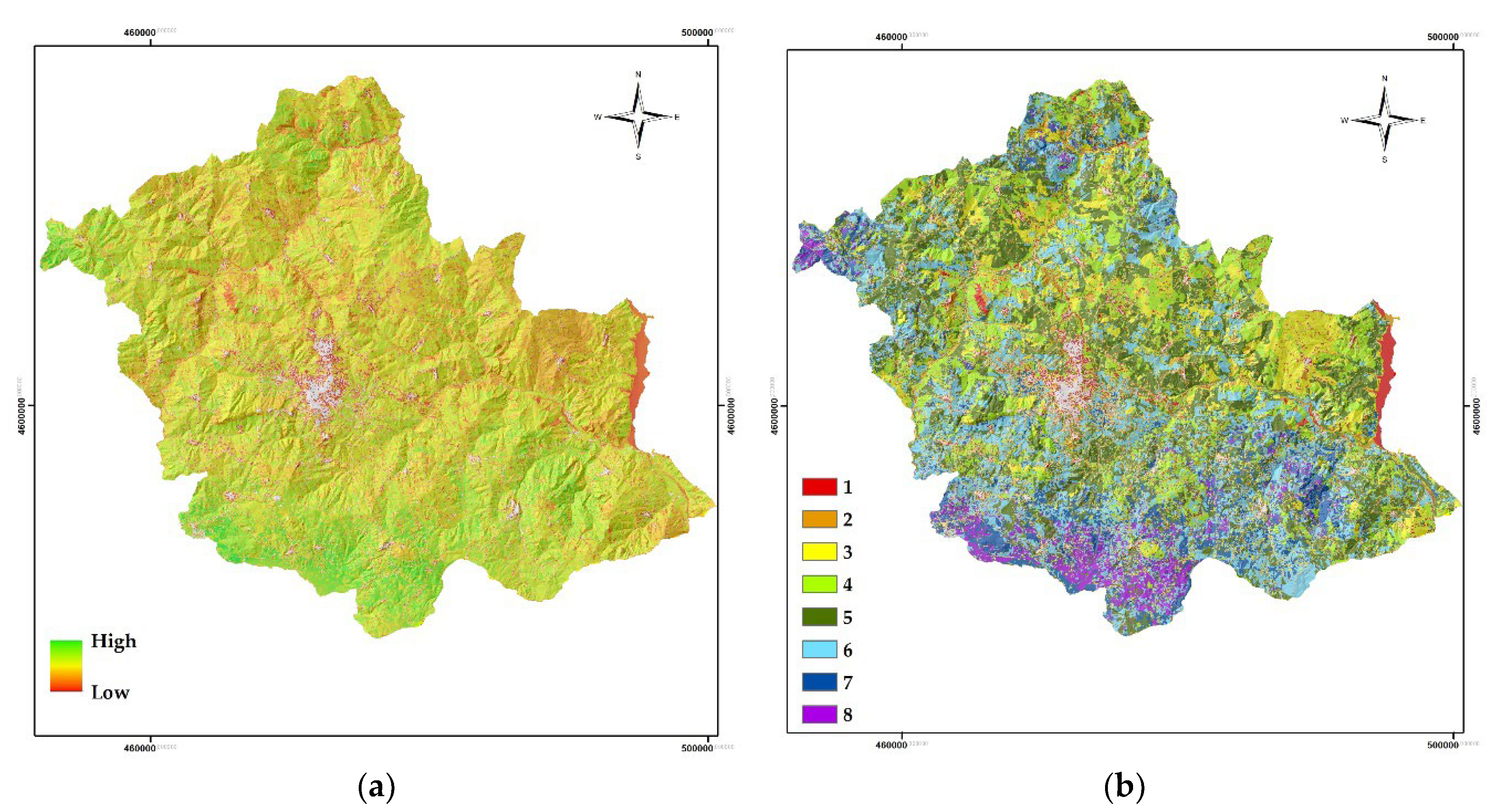
Figure 6.
Distribution of clusters according to “Croplands”.
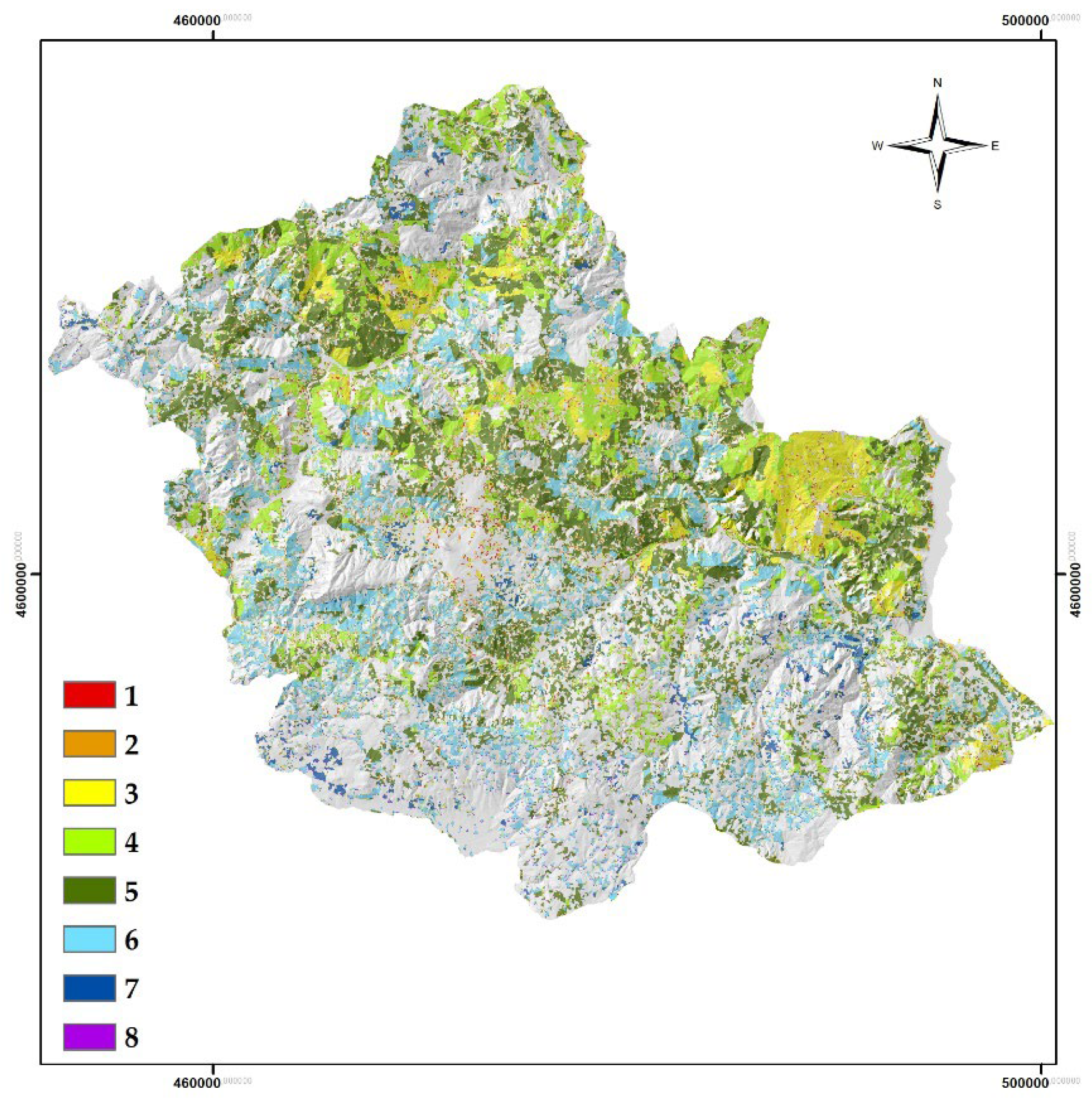
Figure 7.
a) Cluster 1 areas with detail on those falling under Croplands; (b) Cluster 8 areas with detail on those falling under Croplands.
Figure 7.
a) Cluster 1 areas with detail on those falling under Croplands; (b) Cluster 8 areas with detail on those falling under Croplands.
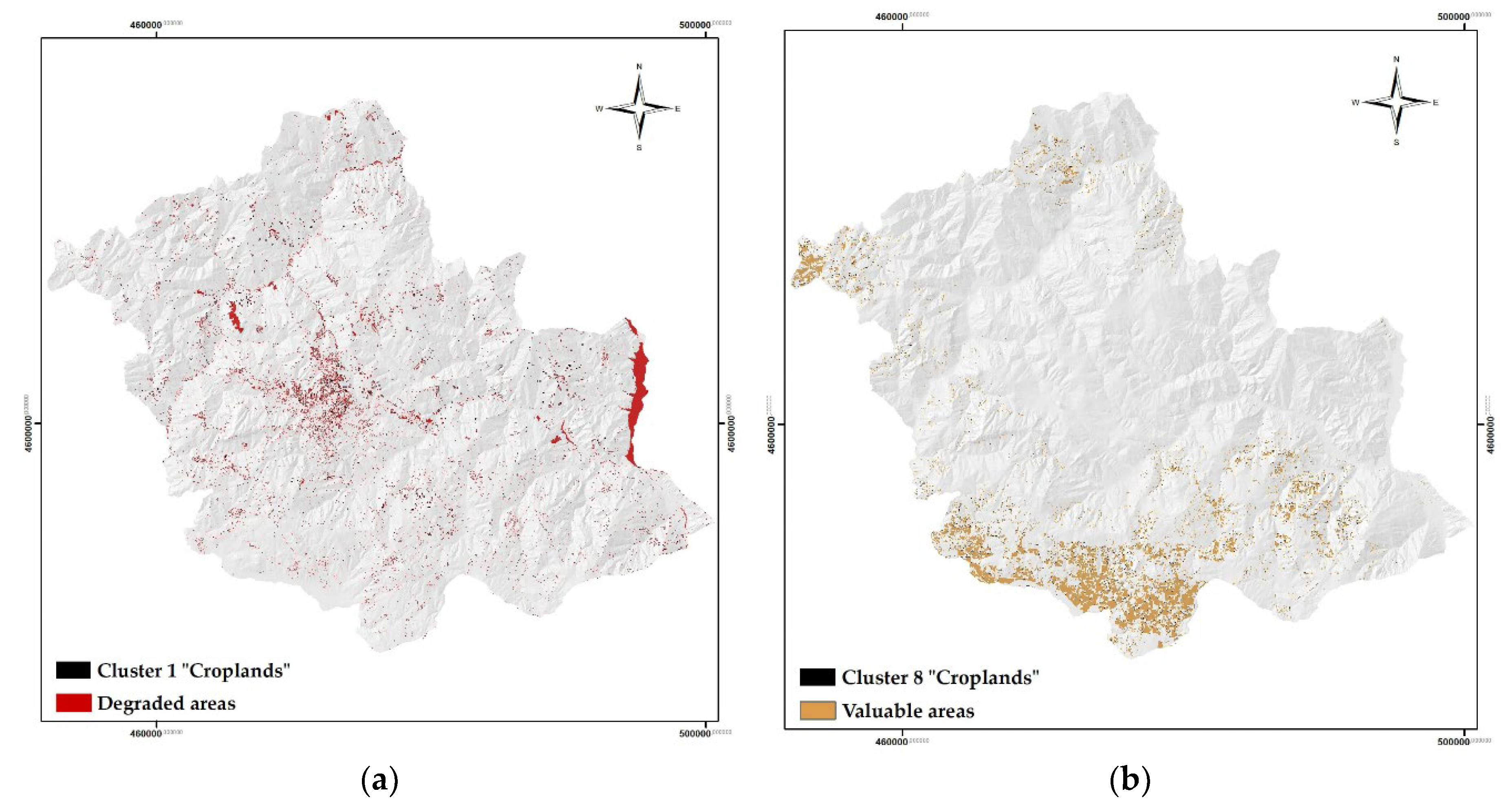
Figure 8.
Potential forest. In red the newly added areas (cluster 1 Croplands).
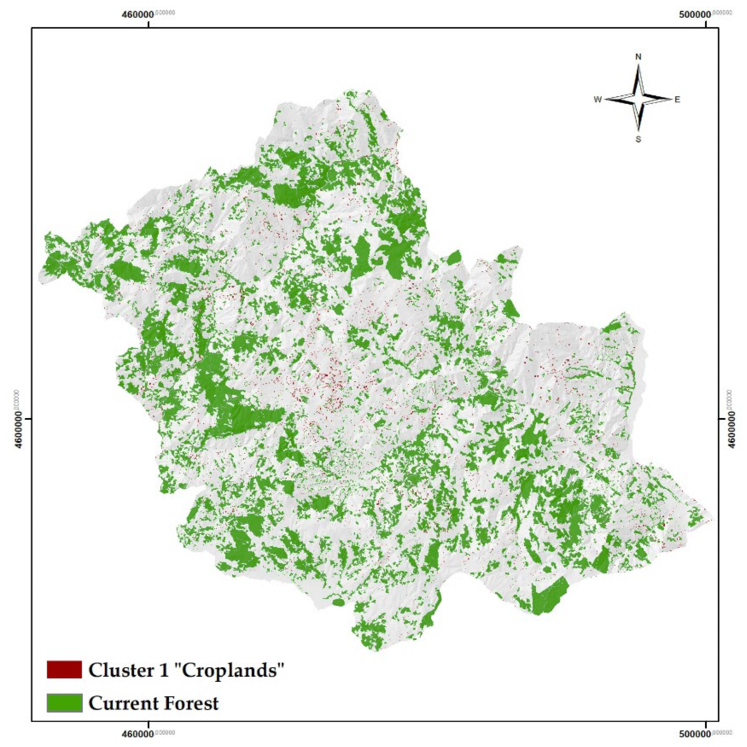
Figure 9.
Degraded areas and 60 m urban buffer.
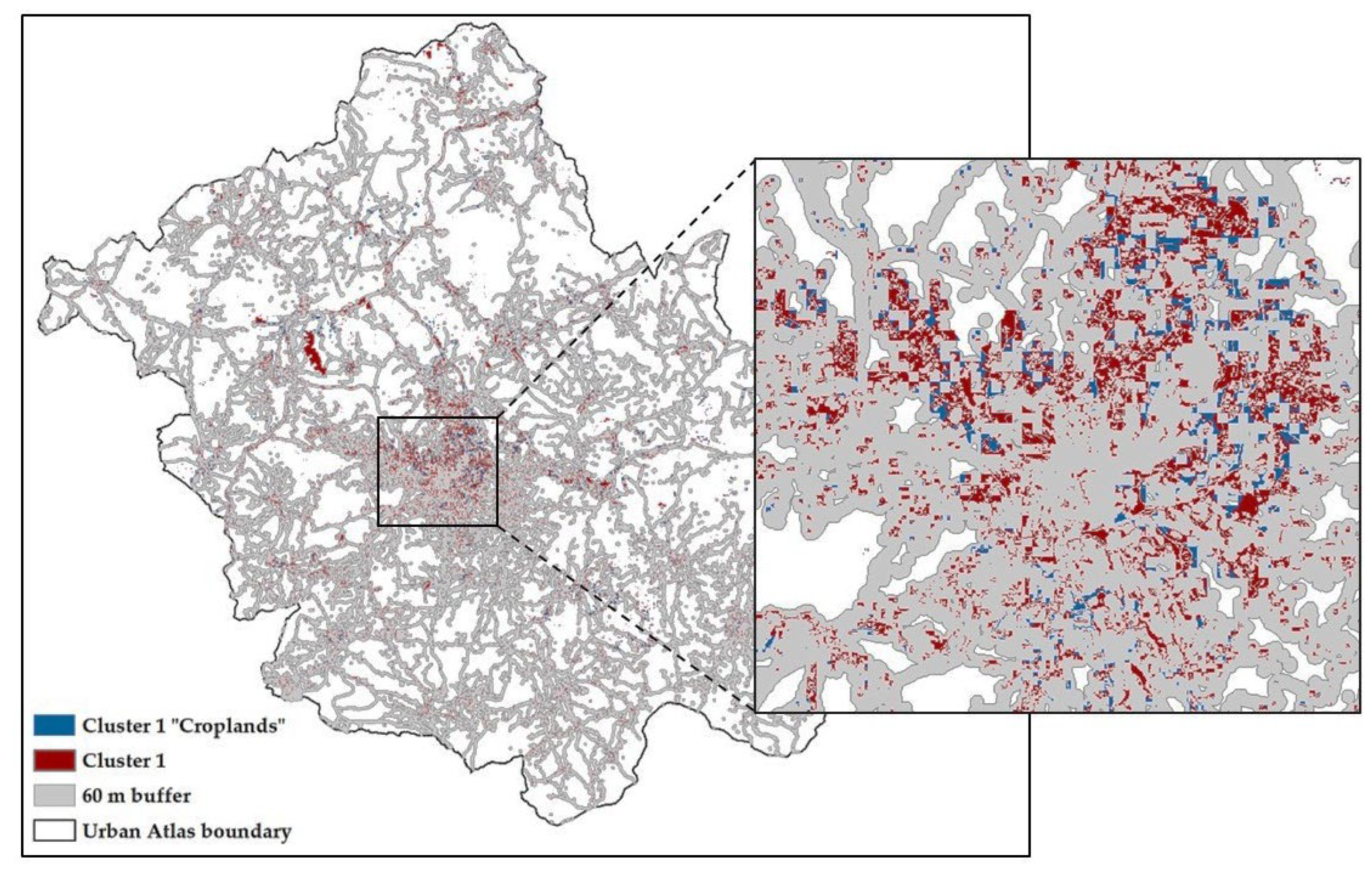

Table 1.
Relative weights of considered criteria.
| HbQ | Pol | LCap | CSS | AP | CR | |
|---|---|---|---|---|---|---|
| Q1 | 0.1687 | 0.1687 | 0.4195 | 0.0743 | 0.1687 | 0.03 |
| Q3 | 0.5557 | 0.1193 | 0.0572 | 0.2337 | 0.034 | 0.10 |
| Q4 | 0.2896 | 0.1367 | 0.2552 | 0.2724 | 0.0461 | 0.08 |
| Q5 | 0.3349 | 0.1195 | 0.2945 | 0.1243 | 0.1268 | 0.2 |
| Q7 | 0.3686 | 0.2339 | 0.1335 | 0.0546 | 0.2093 | 0.07 |
| Q8 | 0.327 | 0.3643 | 0.1004 | 0.1376 | 0.0707 | 0.08 |
| Q9 | 0.5131 | 0.259 | 0.0514 | 0.1481 | 0.0285 | 0.08 |
| Q12 | 0.3257 | 0.3799 | 0.1101 | 0.1451 | 0.0393 | 0.08 |
| Q13 | 0.4533 | 0.1148 | 0.1353 | 0.0821 | 0.2145 | 0.16 |
| Q16 | 0.3188 | 0.2832 | 0.0699 | 0.2969 | 0.0311 | 0.15 |
Table 2.
Weights assigned to layers using expert based approach and respective standard deviation.
| Criteria | Weight | Standard Dev. |
|---|---|---|
| HbQ | 0.36554 | 0.11 |
| Pol | 0.21793 | 0.10 |
| LCap | 0.1627 | 0.12 |
| CSS | 0.15691 | 0.08 |
| AP | 0.0969 | 0.08 |
Table 3.
Selected class and landscape metrics.
| CLASS METRICS | LANDSCAPE METRICS |
|---|---|
| Patch Density (PD) Landscape Similarity Index (LSI) Total Core Area (TCA) Euclidean Nearest Neighbour Distance (ENN_MN) Euclidean Nearest Neighbor Distance (Area-Weighted Mean) (ENN_AM) Percentage of like adjacencies (PLADJ) Normalized Landscape shape index (NLSI) |
Average Area (AREA_MN) Mean Radius of Gyration (GYRATE_MN) Number of Disjunct Core Area (NDCA) Disjunct Core Area Density (DCAD) Aggregation Index (AI) |
Table 4.
Range of values for each identified cluster (A), and area both in hectares and percentage by cluster (B).
Table 4.
Range of values for each identified cluster (A), and area both in hectares and percentage by cluster (B).
| A | B | |||||
|---|---|---|---|---|---|---|
| Cluster | Minimum value | Maximum value | Cluster | Area (Ha) | Area % | |
| 1 | 0.046 | 0.268 | 1 | 3470.3 | 3.37 | |
| 2 | 0.268 | 0.348 | 2 | 8139.9 | 7.91 | |
| 3 | 0.348 | 0.403 | 3 | 12930.2 | 12.57 | |
| 4 | 0.403 | 0.446 | 4 | 18292.2 | 17.78 | |
| 5 | 0.446 | 0.484 | 5 | 25334.4 | 24.63 | |
| 6 | 0.484 | 0.529 | 6 | 20966.9 | 20.38 | |
| 7 | 0.529 | 0.597 | 7 | 9011.6 | 8.76 | |
| 8 | 0.597 | 0.823 | 8 | 4718.2 | 4.59 | |
Table 5.
Percentage of individual clusters compared to the area of the class “Croplands”.
| Cluster | Area (Ha) | Area % |
|---|---|---|
| 1 | 740,09 | 1,42 |
| 2 | 3450,09 | 6,60 |
| 3 | 5991,32 | 11,46 |
| 4 | 10637,76 | 20,35 |
| 5 | 16843,73 | 32,22 |
| 6 | 12116,36 | 23,18 |
| 7 | 2012,49 | 3,85 |
| 8 | 482,88 | 0,92 |
Table 6.
Class metrics: comparison between current and potential forest.
| Metrics | Current Forest | Potential Forest |
|---|---|---|
| PD | 4.8177 | 7.6036 |
| LSI | 96.6678 | 109.9036 |
| TCA | 26269.55 | 27011.85 |
| ENN_MN | 50.9801 | 44.3603 |
| ENN_AM | 28.2223 | 26.0803 |
| PLADJ | 94.0350 | 93.3110 |
| NLSI | 0.0591 | 0.0663 |
Table 7.
Landscape metrics: comparison between current and potential forest.
| Metrics | Current Forest | Potential Forest |
|---|---|---|
| AREA_MN | 2.7146 | 1.7686 |
| GYRATE_MN | 28.9786 | 22.7855 |
| NDCA | 9677 | 15273 |
| DCAD | 4.8177 | 7.6036 |
| AI | 94.0930 | 93.3679 |
Disclaimer/Publisher’s Note: The statements, opinions and data contained in all publications are solely those of the individual author(s) and contributor(s) and not of MDPI and/or the editor(s). MDPI and/or the editor(s) disclaim responsibility for any injury to people or property resulting from any ideas, methods, instructions or products referred to in the content. |
© 2024 by the authors. Licensee MDPI, Basel, Switzerland. This article is an open access article distributed under the terms and conditions of the Creative Commons Attribution (CC BY) license (http://creativecommons.org/licenses/by/4.0/).
Copyright: This open access article is published under a Creative Commons CC BY 4.0 license, which permit the free download, distribution, and reuse, provided that the author and preprint are cited in any reuse.


