1. Introduction
Urban space is commonly understood as a public place in which activities of simple crossing, meeting, leisure and socialization take place. At the macro-urban scale, it is identified with pedestrian and/or multimodal streets, squares, parks while, at the micro-urban scale, with gardens, vegetable gardens, paths, small squares and open spaces.
Today, in light of the potential risks arising from climate change, which increasingly threaten human settlements, the capacity for adaptation, resilience and mitigation offered by urban spaces, both public and private, enhanced by the application of appropriate design solutions, can help reduce risks and improve conditions of environmental well-being.
This contribution is the result of a workshop promoted by the Department of Architecture of the University of Palermo in collaboration with the Municipality of Naro, in the province of Agrigento (Sicily, Italy), and focuses on the case of an urban space without a precise identity and denied to public use, within the fabric of a minor historical center in the Sicilian hinterland. Through some reflections on the analysis of citizens’ needs, as well as on the characteristics of the environmental context, the space is redesigned with a biophilic approach, which aims to create an oasis of comfort: the well-being of the users of these spaces becomes the main objective of the project. The integration of greenery, the creation of shaded rest areas, spaces for conversation or play, the addition of a panoramic walkway, the choice of using natural materials, attention to physical accessibility for the disabled, are the elements for the design of a place with a strong identity that dialogues with the urban fabric, grafting onto the historic staircase and improving its livability.
This means no longer considering the indoor space separate from the outdoor space, but rather aiming for the integration between them using the urban “greening project” as a filter, bringing widespread well-being. The appropriate use of green and blue technologies is in fact studied and evaluated as a substantial method for the health of the city of Naro, through the adoption of suitable tools for the mitigation of urban heat, the improvement of air quality and the enhancement of biodiversity. In this case, the relationship of strong interconnection and interdependence between architecture and nature requires a paradigm shift that places the relationship between human beings and the environment in a new perspective, assuming an eco-centric and no longer ego-centric vision [
1].
In this perspective, the project on Naro aims to be an example of an interdisciplinary approach, respectful of the existing, which places the comfort and well-being of the user at the center of the design. An example that is easily replicable and adaptable in other contexts.
1.1. Urban Space Functions and Requirements
All urban public spaces are characterized by specific functions. The first study on the possible uses of public space in the city is due to the Danish architect Jan Gehl, author of a work that is still of valid help today for the definition of the relationships between public spaces and use. The author identifies the functions of public space in relation to the activities that can be carried out, distinguishing them into necessary, voluntary and social [
2]. Necessary activities are independent of our will but fall within a scope linked to the daily commitments of each individual such as moving to go to work or study, shopping or running errands. Voluntary and social activities are instead actions that each of us chooses to do for our own pleasure or enjoyment such as taking a walk, playing sports, meeting people, playing, reading a book, participating in meetings, concerts, temporary exhibitions. The function of these spaces is to attract different types of people. If a public space has poor environmental quality, it is destined to host only necessary activities that must be carried out continuously regardless of the weather conditions or the pleasantness of the route. It is also true that if the public space in which necessary activities take place is welcoming, this certainly improves the comfort of passers-by. Voluntary and social activities, on the other hand, being all actions that people choose to do, require welcoming spaces that can be used even for extended periods of time.
In order for all urban public spaces, whether intended for necessary activities or voluntary and social activities, to guarantee conditions of usability and well-being, they must possess compositional and aesthetic qualities as well as requirements of livability, attractiveness and comfort.
1.2. Comfort Outdoor, Environmental Variables amd Intervention Strategies
Comfort is the result of a sum of concomitant sensory perceptions due to environmental and subjective variables. Environmental variables are identified with air quality, microclimate, sound, light; subjective variables depend on the characteristics of the clothing worn or the overall thermal resistance that these oppose to heat transfer, but they also depend on energy expenditure or the energy produced by metabolism by the body surface during each activity performed.
Different sensory perceptions can determine sensations of thermo-hygrometric, respiratory-olfactory, acoustic, optical-visual well-being (or discomfort) that define indoor and outdoor environmental comfort.
To ensure the environmental comfort of an urban space, it is necessary to proceed with the environmental analysis of the area under study, followed, if necessary, by proposals for appropriate strategies, aimed at improving the conditions of well-being and which can be solutions with a prevalently natural character (
nature-based solutions—
green solutions), with a prevalently artificial character (
grey solutions) or mixed (
blue solutions) (
Figure 1).
Environmental analysis involves determining the geographical location as well as carrying out accurate investigations into air quality, thermo-hygrometric conditions (solar radiation, temperature, air speed, relative humidity), lighting conditions, and noise levels.
1.2.1. Air Quality
The factors that significantly influence air quality are the presence/absence of pollutants and smog from vehicular or industrial traffic. These are data that can be deduced from specific instruments. Natural strategies aimed at improving air quality essentially materialize with the use of vegetation which, at the macro and micro scale, also contributes to improving the attractiveness of an urban space. Strategies with a prevalently artificial nature can be traced back to the use of coatings and paints with particular properties that allow the degradation of harmful organic and inorganic substances present in the air. Photocatalytic titanium dioxide paints are particularly interesting. Exposure to sunlight allows the activation of the photocatalytic chemical reaction, ensuring a daily decrease in harmful gases present in the surrounding environment. Mixed strategies include solutions that involve the presence of moving water, obtained from fountains and jets. The air near moving water is particularly rich in negative ions that neutralize polluting molecules and microbes.
1.2.2. Thermohygrometric Conditions
The factors that influence thermos-hygrometric conditions i.e., the thermal exchanges between the subject and the external environment, depend substantially on the morphological and dimensional characteristics of the urban space, which act predominantly on the quality of life of users as they determine the conditions of solar radiation and the consequent air temperature, but also the action of the wind, humidity, glare phenomena, and sound dissipation (
Figure 2). Thermohygrometric conditions are also influenced by the characteristics of the soil and covering materials.
Solar radiation. The dimensions of external spaces are decisive for the incidence of solar radiation on the soil. Knowledge of the sky view factor (SVF), i.e., the quantity of portion of sky visible from a point in the urban space, allows us to determine the quantity of solar radiation that can affect the urban space during the day. If the sky is completely visible, the SVF value is equal to 1; if it is not visible at all, the SVF value is equal to 0.
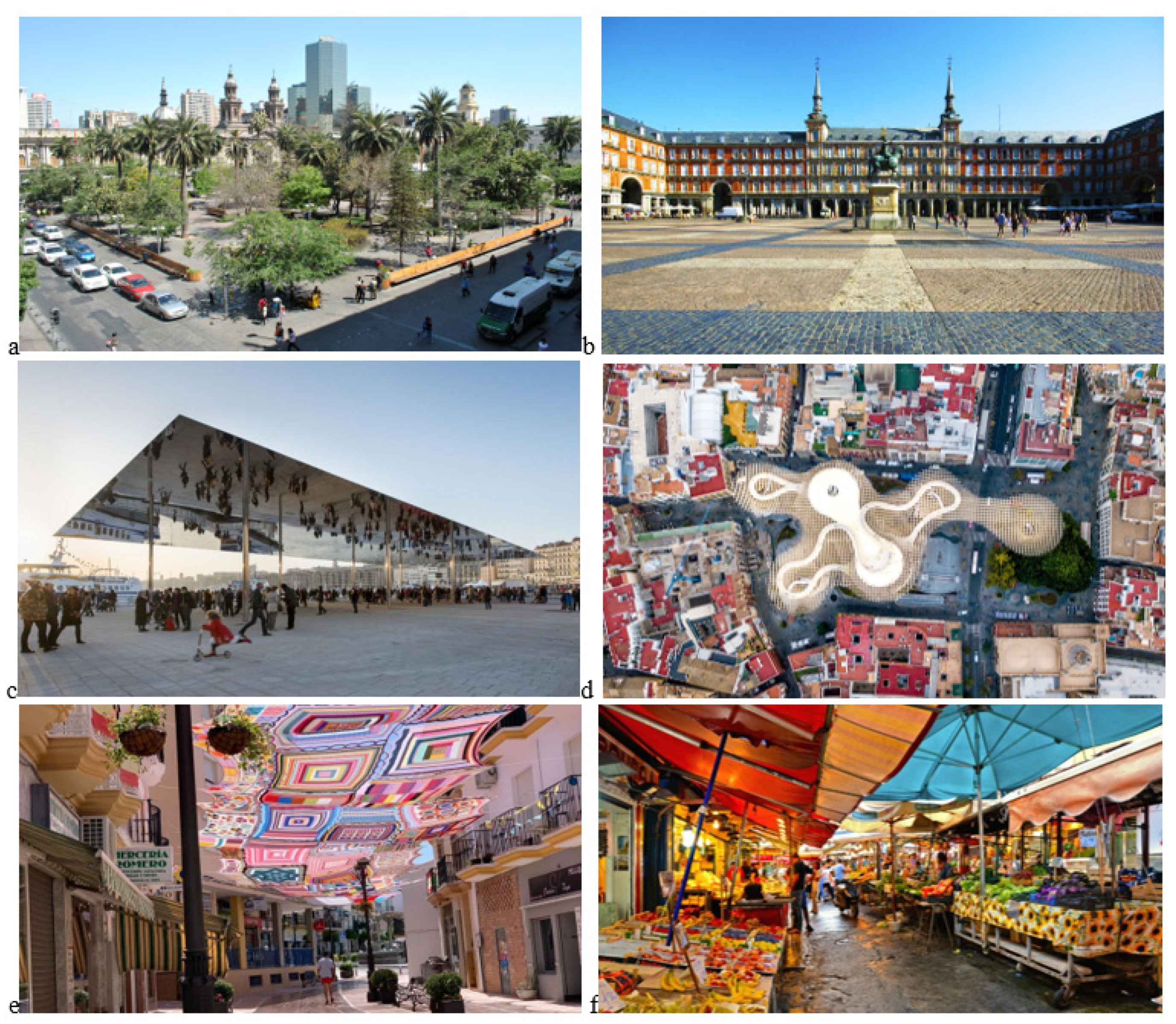
In very large or medium-large open spaces, surrounded by low-rise buildings, solar radiation directly impacts the ground, which partly reflects it and partly absorbs it, subsequently emitting it in the form of heat (
Figure 3a,b). This condition significantly influences the air temperature, contributing to increasing the heat island phenomenon, which is one of the main factors to pay attention to in outdoor areas of rest and passage. In smaller spaces, the presence of neighboring buildings affects solar radiation with effects and consequences on the penetration of sunlight and perceived temperature. In large or medium-large spaces surrounded by low-rise buildings, natural strategies aimed at controlling solar radiation can also be traced back to the use of vegetation, while artificial ones can include the creation of porticos, canopies, paths and covered areas (
Figure 3c,d). In smaller spaces with adjacent buildings, solar radiation control can be achieved by creating awnings, pergolas and shelters (
Figure 3e,f).
Water presence. The presence of fountains and ponds can help mitigate the rise in temperature caused by solar radiation by exploiting the evaporative cooling technique.
The thermal and mechanical effects generated by the wind can positively or negatively influence the outdoor comfort conditions of large or small outdoor spaces. The presence of adjacent buildings can also contribute to the formation of air currents and fluctuations in perceived temperature. The benefits of air currents are highly desirable in the hot season and in the presence of high levels of relative humidity that can also be found in densely green areas, also influencing the perception of heat or cold. In this case, it is necessary to promote ventilation with structures that channel the wind or elements that create discontinuity.
Air flows. Mechanical effects can instead generate uncomfortable conditions and therefore it is necessary to adopt speed control and damping systems. A valid green strategy for controlling air flows and mitigating the effects of the wind in large spaces is the provision of hedges and green barriers (
Figure 4a,b), made with evergreen trees placed at different heights and with large foliage that act as windbreaks. Windbreaks can also be created through grey solutions that involve the use of prefabricated elements of the most diverse shapes, sizes and materials. More technological solutions are dissipators. Green or prefabricated windbreaks are also recommended for small spaces.
Whether it is a large open space or a small space, the nature of the soil and the covering materials can influence the thermo-hygrometric conditions of an urban area, also acting on the heat island effect in the lower layers. Evapotranspiration is favoured by porous and humid surfaces such as, for example, lawns; on the contrary, it is prevented by impermeable surfaces that tend to accumulate considerable quantities of heat.
It is possible to obtain an evaporative cooling effect also on floors made with artificial permeable materials that allow the surface flow of rainwater under a substrate placed just below the walking surface and made with materials that favour the retention of water. The heat present on the surface of the floor is transferred by conduction towards the water which in turn, evaporating, dissipates it in the ground below [
3].
Solar reflection depends not only on the nature of the material but also on its colour: the darker a surface is, the less it will reflect, while the lighter the material, the greater its reflection coefficient (albedo). The choice of appropriate materials, especially for flooring, significantly contributes to improving thermal comfort, avoiding the heat island effect. Dark and rough materials, called “warm materials” dissipate less heat which, by accumulating, determines an increase in the temperature of the surfaces of the coverings (
Figure 5b). This can be a solution for cold climates where it is necessary to make the most of the effects of solar radiation which, as is known, is significantly lower than that enjoyed in countries with hot climates. In the latter, in fact, materials with a high thermal reflection power must be preferred, therefore light and smooth materials, also called “cold materials”. It is also possible to increase the amount of reflected solar energy by using so-called cold pavements (
Cool Pavements) obtained by inserting specific pigments, paints or aggregates in the composition of outdoor flooring that help keep the surfaces colder than traditional pavements. The effects of cold materials and pavements must however be controlled as the portion of reflected radiation could be excessive and negatively affect comfort (
Figure 5a).
The regulation of the external temperature can also be obtained by appropriately exploiting the combination of cold materials and hot materials as the difference in surface temperature and the consequent difference in pressure between the hot air and the cold air produces convective motions that reduce the perceived temperature (
Figure 5c).
1.2.3. Lighting Conditions
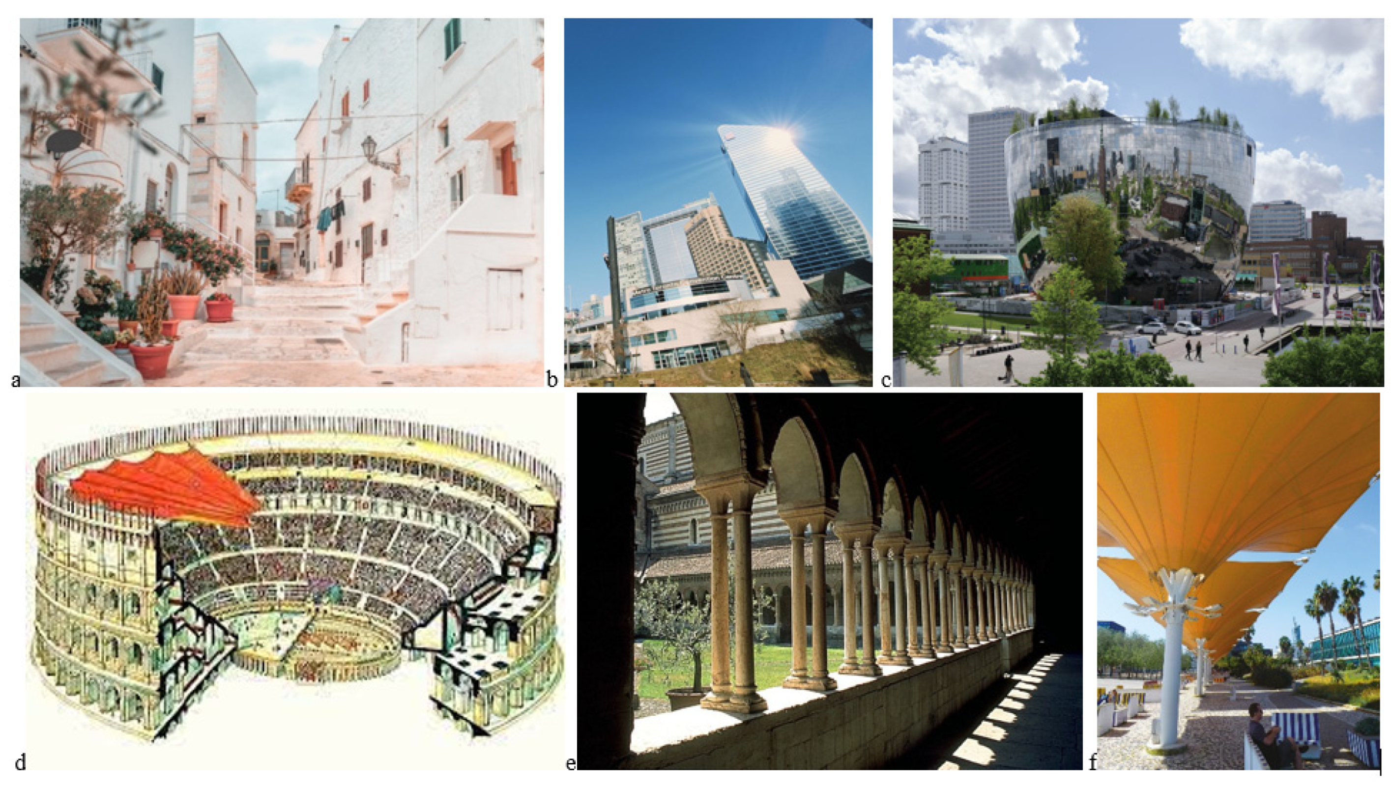
If the use of very light covering materials can be useful to improve thermo-hygrometric conditions in hot climates, it is also true that the high solar reflectance can worsen not only the thermal comfort conditions but also the visual comfort, with glare phenomena similar to those caused by glass and mirror materials.
The brightness conditions in outdoor environments are generally connected to the intensity of solar radiation and therefore, the strategies adopted to improve visual comfort are very similar to those envisaged for thermal comfort. The most common system and also the most used throughout history is the provision of fixed or mobile fabric screens and canopies of various kinds, but also the creation of colonnaded porticos. Today, advanced materials are used, more or less performing, but the solutions are mostly the same.
Figure 6.
a. Pedestrian path in Ostuni, Italy; b. Glass building envelopes; c. Storage area of the Boijmans van Beuningen Museum in Rotterdam, Netherlan, by MVRDV architectural firm;d. Velarium of the Colosseum, Rome, Italy; e. Portico of the cloister of San Zeno Maggiore in Verona, Italy; f. Fixed screens in the Park of the Nations, Lisbon, Portugal.
1.2.4. Noise Level
The noise perceived in open spaces can have different effects on people and depends on the origin and intensity with which it manifests itself. The proximity to more or less busy road systems, airports or other infrastructures can determine conditions of discomfort that tend to drive users away; on the contrary, the noise of water, perceived even from a distance, stimulates people to come closer.
2. Definition of Regenerative and Biophilic Design
“Building nature”, from the urban scale to the detailed one, is a regeneration strategy aimed at restoring degraded ecosystems, mitigating the effects of climate change and sequestering CO2. The lack of extensive vegetation in the built environment also entails the loss of a natural means of cooling through evapotranspiration, which must be restored and enhanced.
Cultivating a design culture, in which “plant material” can be integrated as a structuring component of the regeneration process (technological green), means working with nature by exploiting both the potential of biomimetics (i.e., designing inspired by nature) and the biophilic design (i.e., inserting nature into design) connected to it, to promote well-being and “comfort in inhabited spaces”.
This design approach that insists on the need to regenerate urban spaces by re-naturalizing them, i.e., building urban nature intercalations, has seen the proliferation of distinct schools of thought for many years, diversified above all by their territories of origin in geographical and cultural terms. A regenerative process of urban space in geographical areas of the Mediterranean basin will in fact be different from a renaturation process in Nordic countries and even more so in continental geographical areas, but what they have in common at a global level is the need to respond quickly to the environmental challenges of our time. In support of this thesis there is in fact a substantial literature in the sector that our research activity has explored starting from the concepts linked to the disciplinary tradition of environmental design, up to evaluating the new frontiers of contemporaneity.
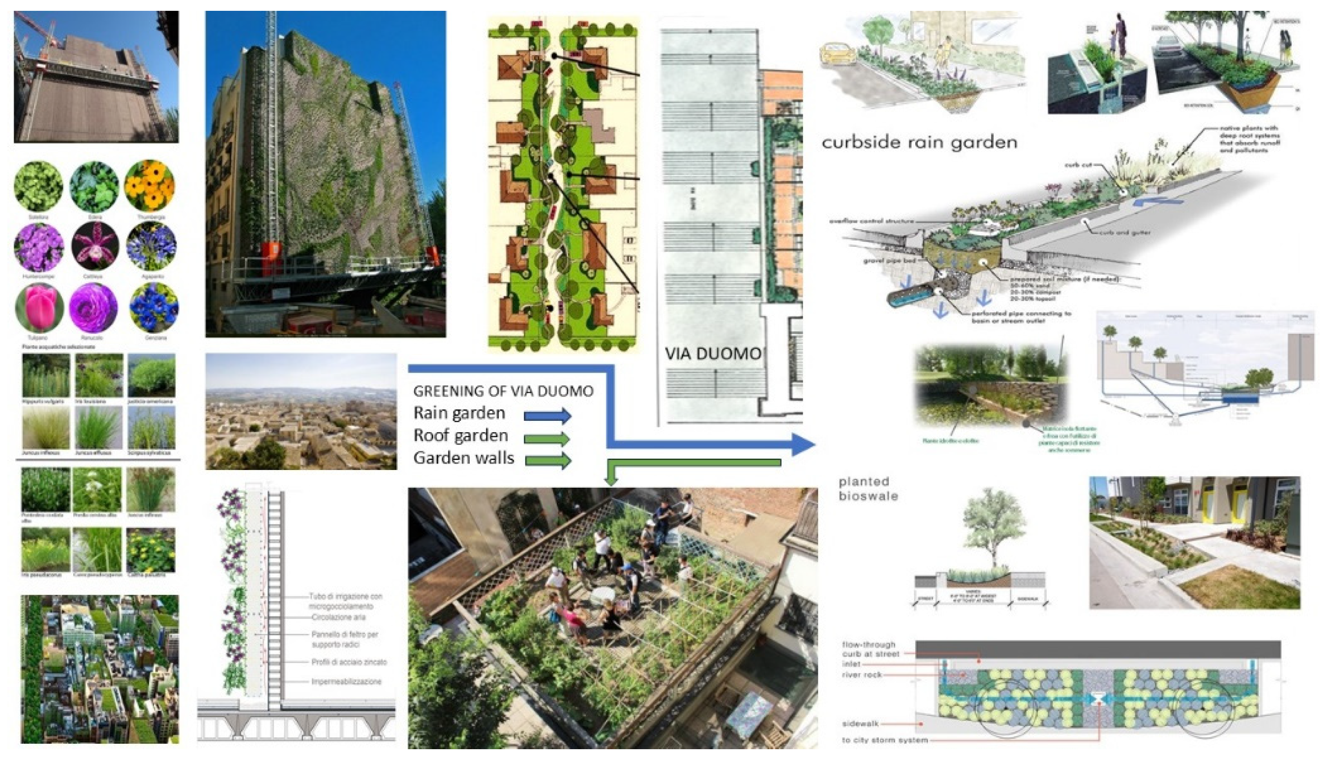
It is important to underline those the procedural and systemic aspects of urban renaturation through the dissemination of technological greenery, which translates into all the declinations in which vegetation can “contaminate” the architectural elements of an urban space, go well beyond the traditional methods of intervention for the redevelopment of the built environment as addressed in the last twenty years. Rather, they imply the initiation of broad and multifaceted transformative processes that simultaneously include urban, social and economic measures that are technologically appropriate, therefore not only the design of roof gardens and garden walls but also the study of biophilic systems that also use blue technologies (water mirrors and rain gardens) to be inserted into the travel systems and urban voids, thus designing new itineraries structured by biological organisms with notable sensorial perception that are healthy, but also attractive in terms of valorising local environmental resources.
2.1. Technical Solutions for Environmental Greening: Examples and Case
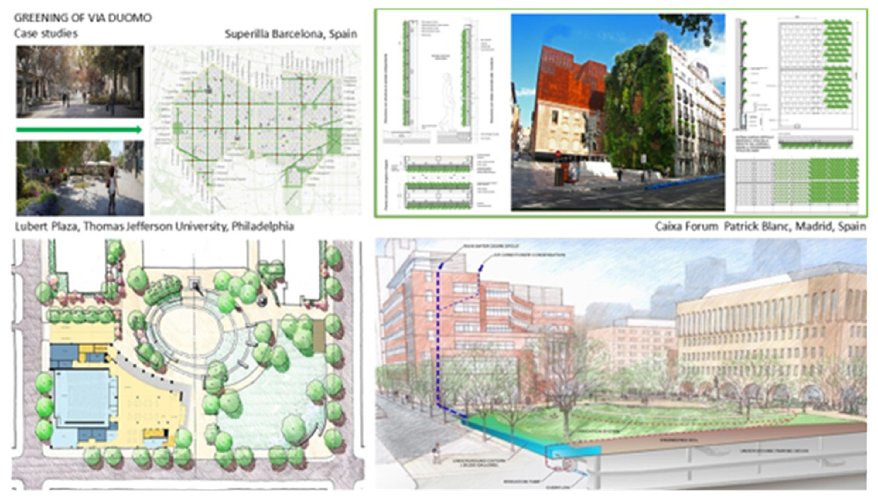
Among the examples of urban greening with a biophilic approach in Europe, the case of
Vitoria-Gasteiz, in Spain, “European Green Capital 2012”, has been studied (
Figure 7). Here, in relation to the social dimension, we are in the presence of a strongly cohesive local community, with a deep-rooted sense of belonging and a strong identity, particularly active in defining the choices for the transformation of the city. One of the most important biophilic projects was the naturalization of the Green Ring, consisting of the system of peri-urban green spaces formed by the parks of Armentia, Salburua, Olarizu and Zabalgana and the related interconnections that allow the integration of the urban fabric with the surrounding natural heritage, thus promoting relationships between urban green spaces and the green spaces of the agricultural area. This strategy is particularly adaptable to many internal Sicilian villages morphologically immersed in the surrounding nature. Interesting is the naturalization of the main axis that creates an impressive green area, where the stream creates a biodiversity hotspot in the centre of the city.
Another emblematic example of urban transformation with a biophilic approach is the case of Barcelona. The municipality of Barcelona is adopting an urban regeneration policy based on greening. The superillas (in Catalan, “super islands”) are super blocks of nine blocks, within which the space, until now occupied by cars, would, after the intervention, be dedicated to pedestrians and cyclists. The scheme of these particular urban islands is an idea of Salvador Rueda, urban planner and director of the Agencia Ecologia Urbana de Barcelona. The project, supported by the former mayor of Barcelona Ada Colau, is underway: four streets in the Eixample will be converted into green pedestrian axes, street furniture will be installed along the routes and vegetation will be placed that will occupy 12% of the space, thanks to the planting of 400 trees and 8,000 cubic meters of shrubs. Barcelona is now a representative example of environmental planning with a biophilic approach that can be perfectly extended to the Mediterranean basin and beyond.
In terms of urban greening systems and tools for habitat regeneration, research has also explored the use of blue technologies through the study of specific linear or sinusoidal gardens, bioswales, rain gardens and biophilic elements to be inserted along pedestrian walkways and urban voids in the town of Naro.
The example shows a system designed by Laurie Olin to capture, filter, clean and recycle rainwater from downtown Cambridge, Massachusetts. A landscaped basin containing plants, sand and boulders, placed on top of a large Silva cell storage basin, which ensures bio-filtration and prevents runoff water from entering the municipal sewer system. A system of water paths mixed with vegetation is in fact a useful strategy
Another example analysed is the Lubert Plaza project by Andropogon, at Thomas Jefferson University in Philadelphia. The square effectively manages on-site rainwater, including condensation from adjacent buildings’ air conditioning, through infiltration, capture, treatment and reuse for irrigation. In this perspective, biophilic urban regeneration should be understood as a cultural approach that can be extended to all territories in relation to the different peculiarities present in the different contexts.
3. Materials and Methods
As mentioned in the introduction, the present article reports the results of a part of a more complex study, named “Workshop Naro”, which combined teaching, laboratory, and research activities that were carried out at the Master’s Degree in Architecture at the University of Palermo. The general scope of the workshop was to provide the municipality administration of a Sicilian town i.e., Naro, with innovative while feasible urban and architectural regeneration suggestions. The whole activity was accomplished through the definition of thematic groups made of students, researchers, and professors, focused on specific design area and goal. In particular, the present article regards the study accomplished by two thematic groups i.e., Environmental Design and History of Architecture. The project site was chosen in order to have the opportunity to valorize an outdoor area featured by historical architectural and cultural value with greening and urban design solutions aimed at enhancing the urban comfort. Hence, once the project site was preliminarily analyzed from both the historical and environmental perspectives, in order to identify its strengths and weaknesses, the intended use of the area together with the concept design were proposed and, finally, the preliminary design drawings were elaborated. The adopted method is summarized in
Figure 8.
4. Results: The Pilot Case Study of Naro Municipality
4.1. Historical Analysis of the Context
The small town of Naro, in the Sicilian hinterland (Italy), presents in its oldest core material evidence of a significant centuries-long history. The monumental consistency of the historical-architectural heritage passes down the memory of periods of magnificence and prosperity known by the town, in alternating phases, especially between the 14th and 18th centuries. These testimonies concern in part the sphere of civil architecture, but above all that of religious architecture, defining zones of power within an urban design that adapts to the orography of a site characterized by a marked slope.
Two monumental buildings, the castle and the mother church, both of medieval foundation, stand out in the highest part of the town, facing each other at a short distance (
Figure 9), characterizing the urban image of Naro and dominating the remaining urban fabric, which has developed over the centuries along the slope of the hill site.
Although local historiography dates the foundation of the oldest nucleus of the castle to the 9th century, at the time of Islamic rule, and that of the mother church to the 11th century, that is, at the time of the later Norman domination, for both buildings—over time heavily remodeled and stratified—the oldest parts still recognizable date to the 14th century [
4,
5]. It is precisely to the 14th century, in fact, that an early phase of development and increased importance of the town can be ascribed, especially after its acquisition by Matteo Chiaromonte in 1366 [
6]. Other buildings provide further evidence of this, such as the church of Santa Caterina, among the few newly founded churches in the 14th-century Sicilian architectural context. It is characterized by a basilica plan with a strong longitudinal development and a sequence of very early Doric pseudo-columns, which could be indicative of a continuity with classical culture-even in the medieval period-that finds other significant parallels in the Agrigento area (as observed, for example, in the Chiaromonte palace in Favara [
7]).
Another strong urban sign in the historical fabric of Naro is the present-day Via Dante, the main road artery that cuts longitudinally through the town, continuing beyond the limits of the route of the (no longer existing) walls that encircled the historic center. The definition of this street dates back to the 17th century and is closely linked to the arrival of the Jesuits in the city, for the foundation of their own college, in 1610 [
8,
9]. During the 17th century, the street would take on a growing monumental aspect, lining up along it several convent complexes and some noble palaces. In addition to the aforementioned Jesuit college (located more or less in the center of the monumental street), the imposing convent complex of the Dominicans, settled as well in 1610 [
10], on the edge of the intramoenia city and at the hinge with its eastward expansion, is noteworthy [
11]. Between the two religious complexes of the Jesuits and Dominicans, in an almost barycentric position, are the remains of another monastery founded for a community of Benedictine nuns. This is part of an 18th-century enlargement of the monastery, the so-called “Quarto nobile” [
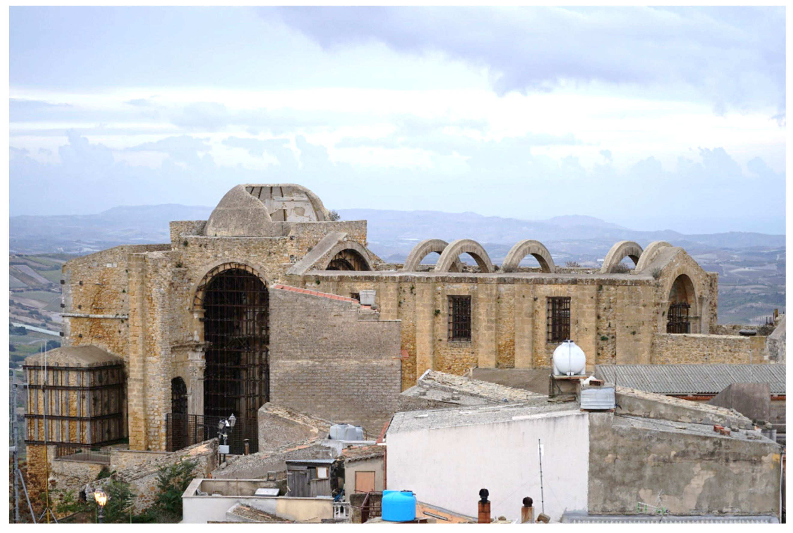
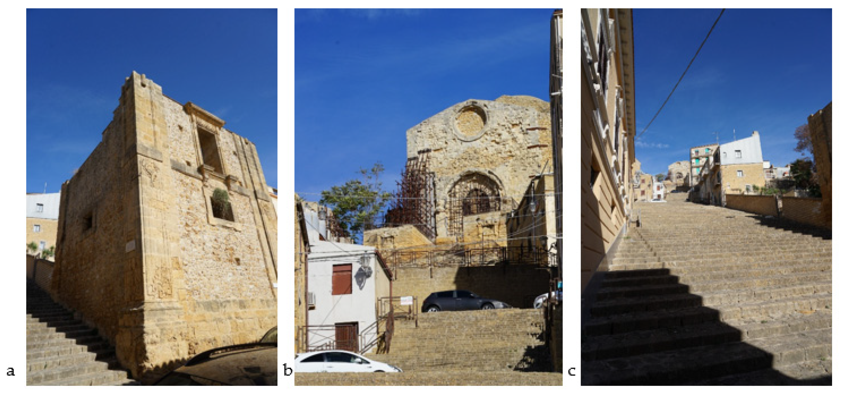
5], of which a single two-level quadrangular building remains—dwarfed at the top and lacking a roof—characterized by large corner pilasters decorated with rococo motifs directly carved into the stone.
The “Quarto nobile” portion of the building and the old mother church (in particular the original 14th-century facade, with its ogival portal decorated by the characteristic zigzag motif) are the two monumental terminals of a scenic, wide stone stairway, which is the main pedestrian and most direct link between the church in question and Via Dante.
The present configuration of the stairway can be traced back to the 18th century, although on a route that was certainly of much earlier origin. By holding together one of the architectural cornerstones of the medieval town and the monumental street that characterizes the arrangement achieved by the same in the Early Modern age, the stairway possesses a relevant historical value, which makes it an urban place of particular interest for the development of a planning reasoning that aims, among other things, at requalification and enhancement (
Figure 10).
4.2. Environmental Analysis of the Context
The municipality of Naro is located in the southern part of Sicily, Italy, at a latitude of 37°17′40”56 North and a longitude of 13°47′39”84 East, within the province of Agrigento, one the main cities in the island. The municipality of Naro it extends for 207 square kilometres on a hill area, and it averagely raises 484 metres above the sea, while its altitude ranges from 128 to 612 metres.
The town of Naro has a population of 7′658 inhabitants, around 4 thousand of which women, with a density of 36.9 people per square kilometre. Its position makes its territory favourable for agricultural activities, mainly regarding viticulture (
Figure 11).
To accomplish the preliminary environmental analysis of the urban context project site, weather data should be collected from official weather stations (e.g., Aeronautics ones). Unfortunately, as Naro has not its own weather station and the closest one are in other municipalities with their weather and orographic peculiarities i.e., Agrigento and Gela, it was not possible retrieve official weather data files of Test Reference Years (TRY) and analyse them with the tool Climate Consultant [
12]. Hence, weather data for Naro were collected from the online resource Weatherspark [
13], which provides mean weather data elaborated based on statistics from a 36-year timespan (1980-2016) from close weather stations (i.e., Palermo, Enna, and Gela), corrected considering the different altitude, and the application of weather prediction models.
In particular, charts about temperatures, people comfort sensation related to relative humidity, winds direction and speeds, and rains were collected, analysed, and compared.
According to the Koppen-Geiger weather classification [
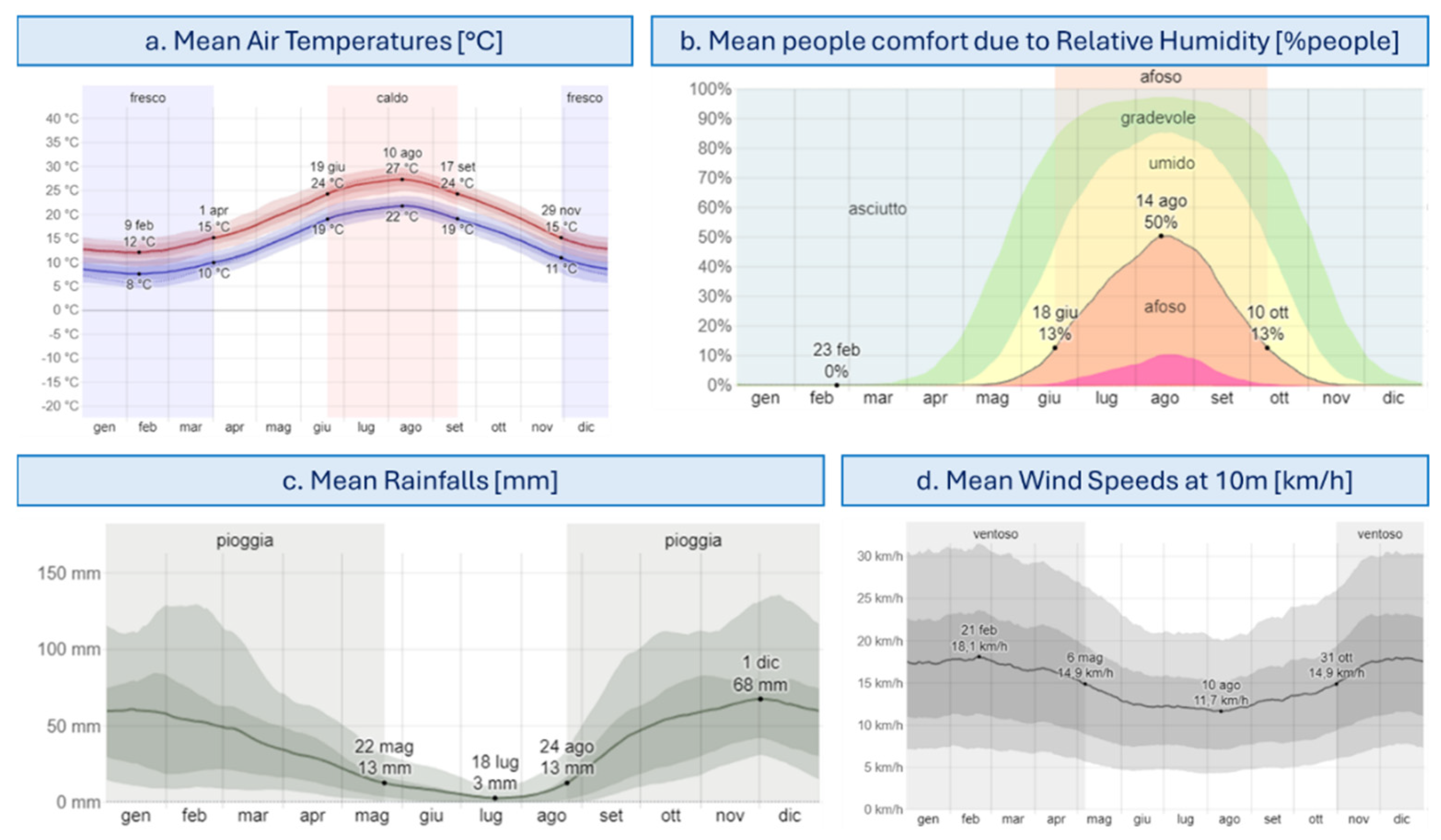
14], the town of Naro, and in general the south cost of Sicily, belongs to the “Csa” zone i.e., temperate climate featured by hot dry summer. Indeed, according to the collected mean temperatures data (
Figure 12a), the winter temperatures in Naro range from 8°C in February to 15°C in November, while the summer temperatures from 19°C in September to 27°C in August, although higher temperatures (between 30°C and 40°C) can be detected more and more frequently.
Hence, it can be concluded that Naro has a mild climate with hot temperatures summer. Indeed, based on the Decree of the Republic President DPR n.412/93 [
15], which divided the Italian territory in six climatic areas i.e., from the hottest one in the South (A) to the coldest one in the surrounding of the Alps (F), it is possible to define the number of “Heating Degree Days (HDDs)” for the town of Naro and so, the proper space heating systems settings. Hence, Naro has 1320 HDDs so, it is in the climatic zone C, which means that heating systems can be activated from November 15th to March the 31st for no more than 10 hours per day.
Regarding the relative humidity (RH) in Naro, from
Figure 12b, it can be noted that it has a great variation throughout the year, with the highest humid period from June to October, where the 13% of people feels sultry. Nevertheless, Naro is not a rainy area (
Figure 12c): most of rainfalls occur from September to April, with a probability of just around 17% of rain per day. Averagely November and December are the rainiest months, with only around 10 days with rainfalls, while July is the lowest one, with 0.6 days.
Lastly, Naro is a quite windy area, as reported in
Figure 12d. In detail, the windiest month is February with 17.9 km/h and in general the coldest months are also the windiest ones; in spring and summer the wind has a lower speed with 11.0 km/h in August; regarding direction the prevailing ones are West and North.
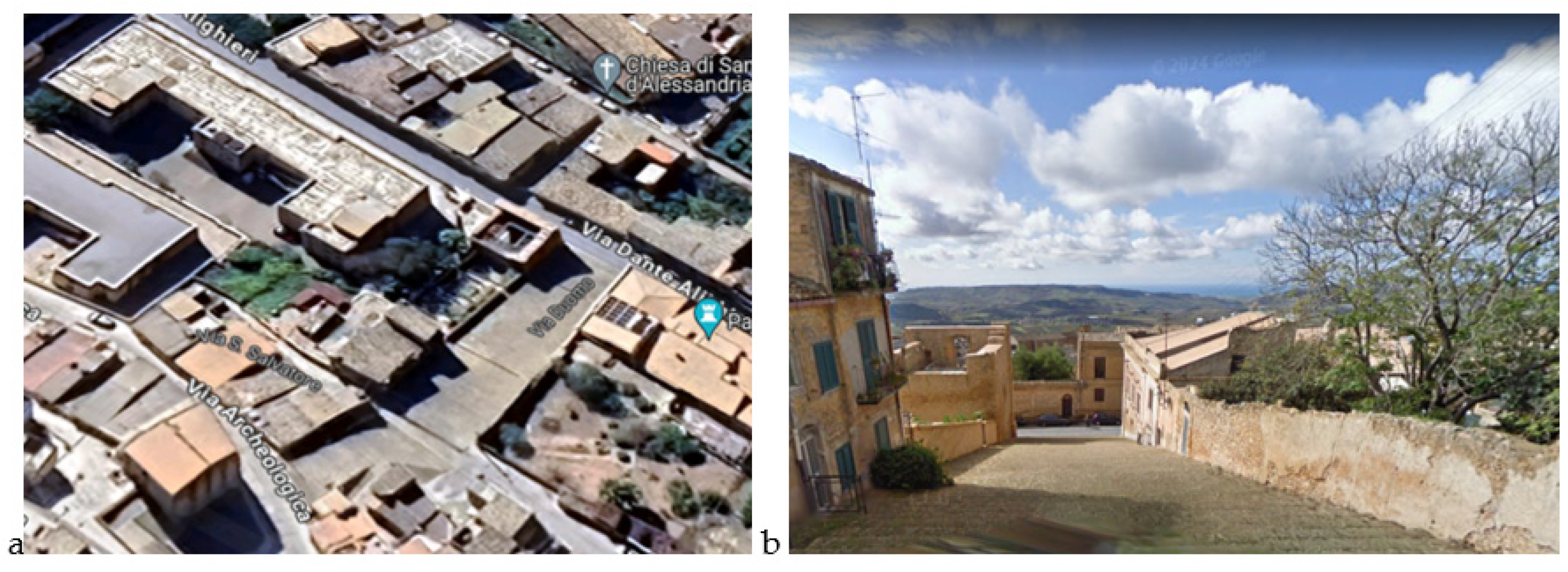
Moreover, to investigate the impact of solar radiation on the project site and possible needs in terms of blinding elements, the presence and location of vegetative and architectural elements was assessed. Thanks to the online resource Google Earth [
16] it was possible accomplishing a qualitative analysis of the vegetation presence that highlighted the existence of few medium size trees in the gardens adjacent to the staircase which are not responsible of relevant shadowing on the staircase itself, while potentially represent a cooler area where to take rest in daytime (
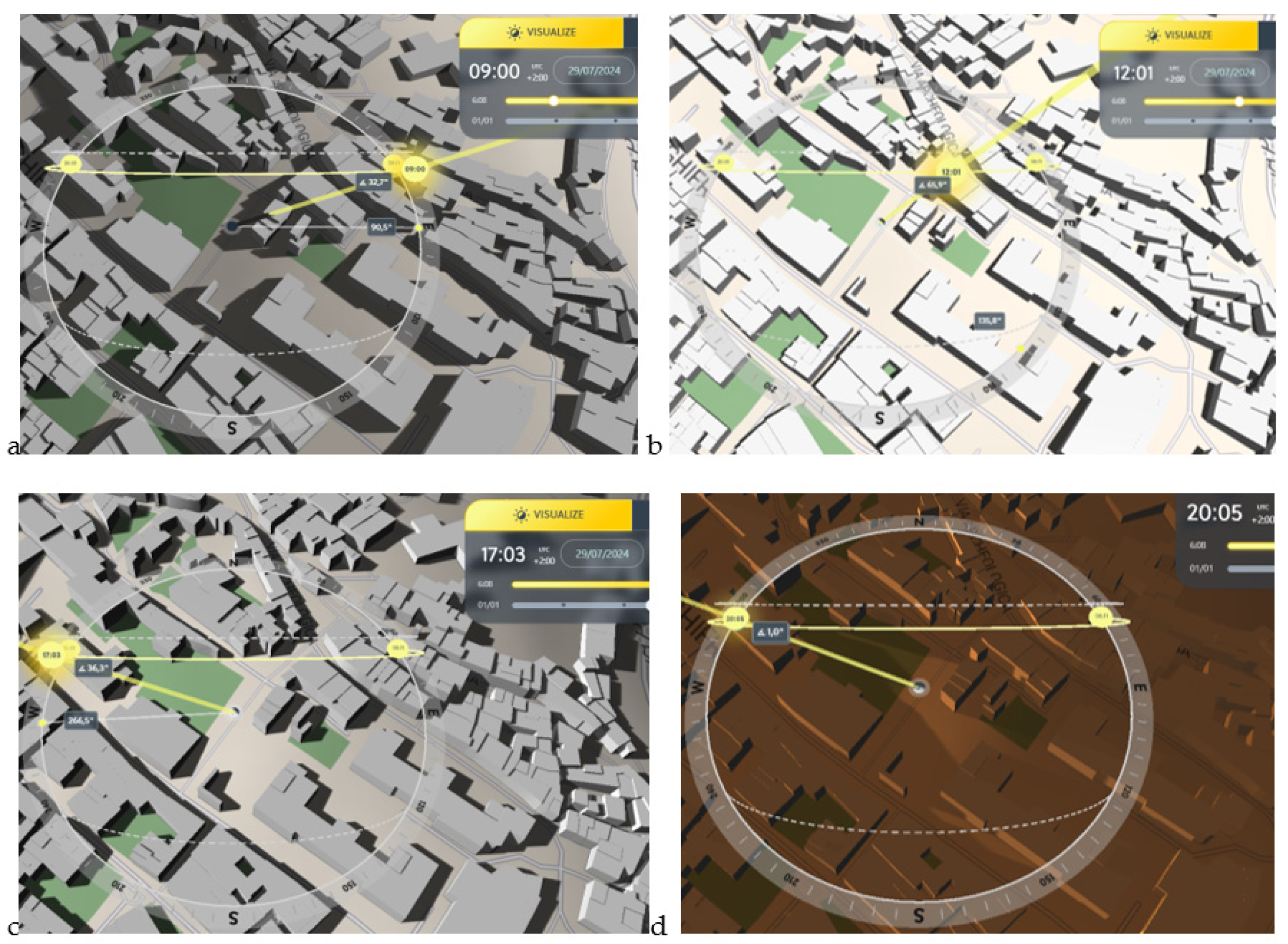
Figure 13). Also, thanks to the online resource ShadowMap [
17], which reports buildings 3D and shadows together with the sunchart, it was possible plotting the building shadows in the project site. Shadows should be analysed and compared with reference to at least 3 seasons (merely winter, summer, and a mid-season) and at least 3 daily periods (merely morning, noon, and afternoon). As an example of the complex analysis, in
Figure 14, the shadows relative to 4 daily times (morning, noon, afternoon, and evening) in summer, as the most demanding period in terms of comfort (highest temperatures, low wind, and high relative humidity), are reported. It can be noted that the staircase is mainly affected by high sun radiation from noon to the afternoon.
This overall environmental analysis was essential to set a matrix of needs as a starting point for defining the concept design criteria to be addressed for enhancing the urban comfort in the design phase.
4.3. Proposed Solutions: the Urban Greening Intervention for via Duomo in Naro
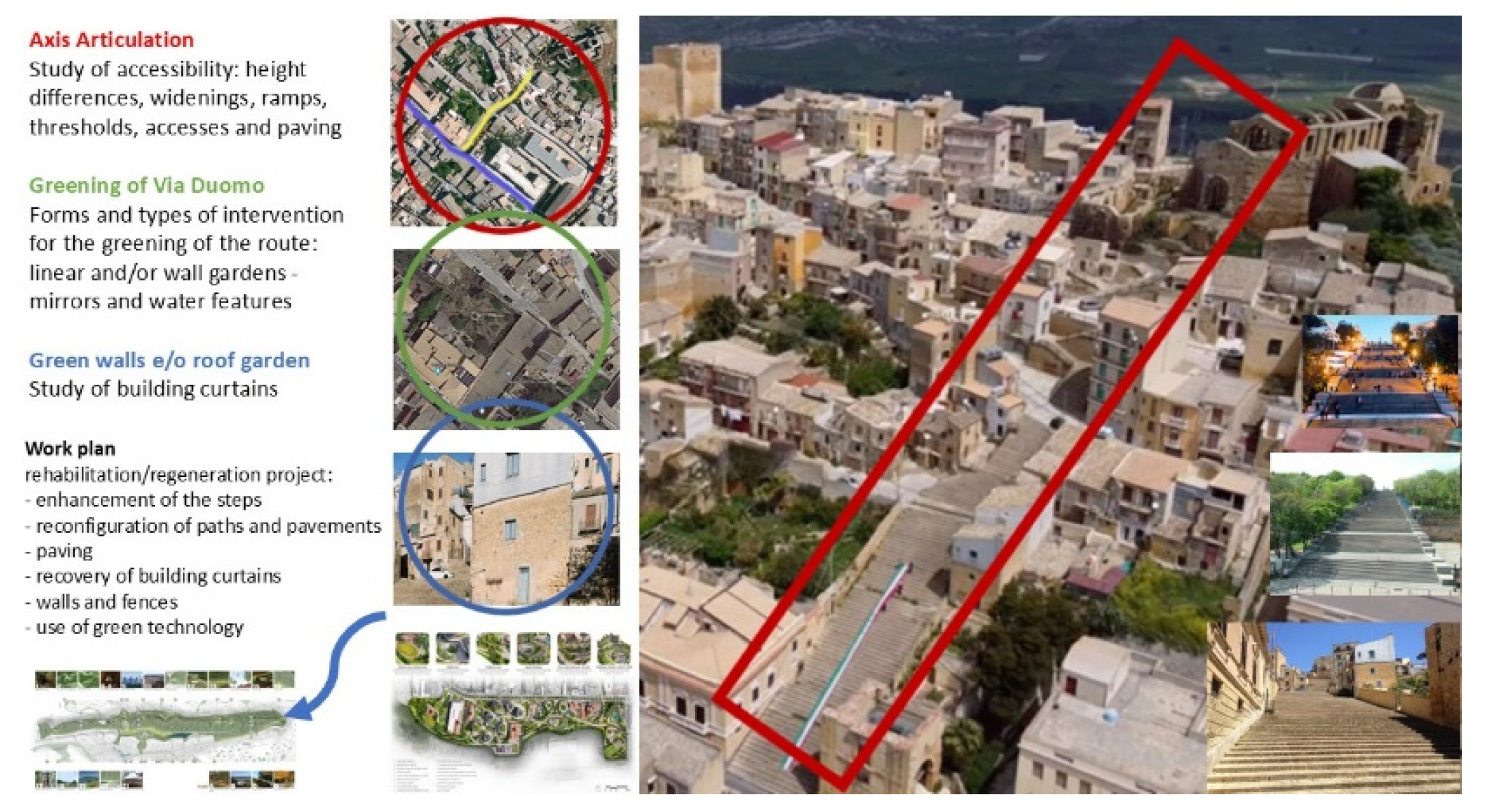
Given the particular morphology of the environmental and landscape context of Naro and the objective assumptions of environmental regeneration: the greening project studied for Via Duomo becomes as necessary as it is natural and appropriate. In this village, the large stairways branch off from the main axis of Via Dante, rich in architectural attractions, where the areas are exclusively dedicated to pedestrians. In particular, the stairway of Via Duomo stands out for its innate architectural, historical and landscape monumentality. Here the urban greening project has the task of bringing together different instances of environmental regeneration and enhancement of local identities (
Figure 15). Via Duomo is revisited as a significant place where it is possible to build an integrated identity itinerary in which the enhancement of the local architectural heritage (recovery of the fourth canto) is combined with a necessary regeneration of the built environment (redevelopment of the body of the stairway, recovery of the building curtains, design of rest and refreshment areas with a strong landscape connotation).
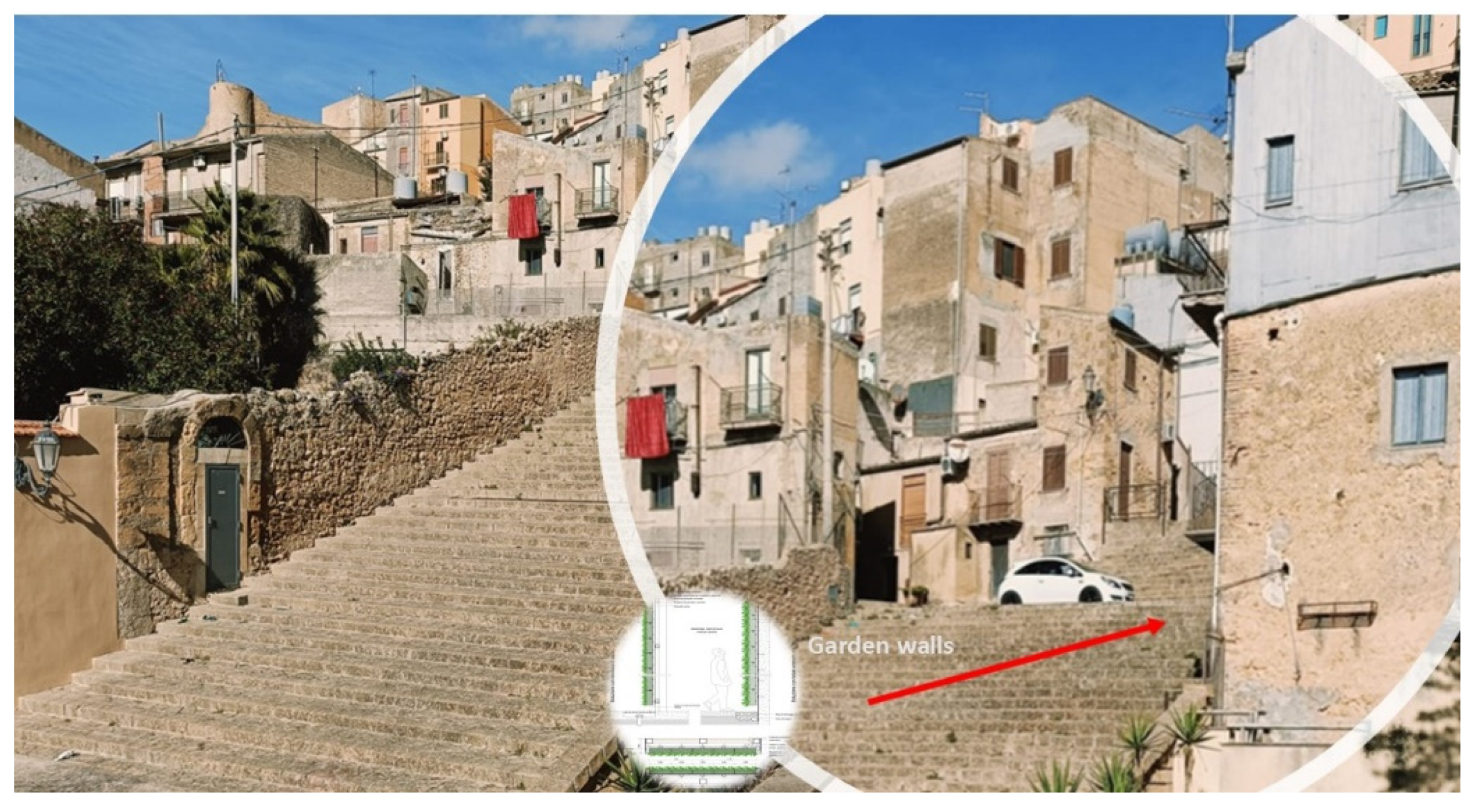
The greening intervention requires adopting a holistic approach to sustainability and raising its benchmark, with this perspective the emerging notion of “regenerative” design and development with a biophilic approach is emphasized: both as a co-evolutionary relationship between humans and the natural environment, and as an action aimed at enhancing the environmental and social capital of the settlement context (
Figure 16).
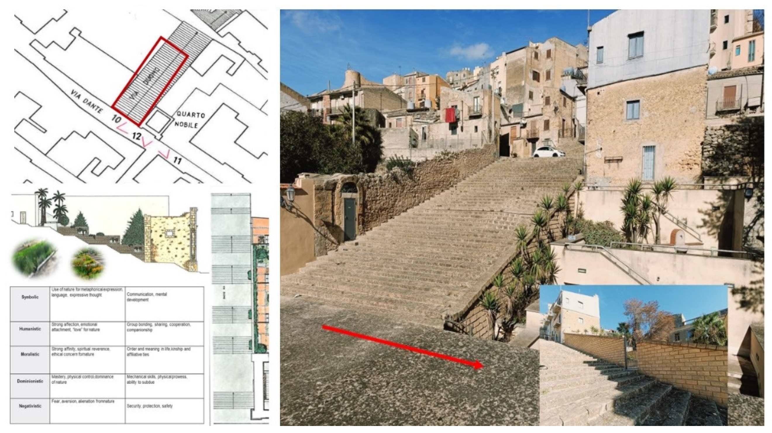
The use of technological greenery in Naro was in fact evaluated and designed also due to the large percentage of impermeable surfaces (building facades, roads, sidewalks) and the lack of extensive vegetation both on Via Duomo and throughout the town center (
Figure 17). This involves, in addition to the loss of a natural means of cooling by evapotranspiration, interesting especially in the summer season, also the loss of a useful contrast to the increase in temperatures generated by the same human activity and by air pollutants (
Figure 18). The absence of vegetation in fact causes a greater accumulation of smog that endangers human health and the environment: “the presence of vegetated surfaces can instead counteract its effects both in terms of comfort performance at a local level and in terms of environmental sustainability at a global level” [
18].
The project of Via Duomo also consists of an in-depth study on accessibility: which involves the walking and parking areas, the threshold points, the downhill and uphill hinges and a study on the use for the construction of real green islands integrated into the surrounding landscape, in particular the design actions were aimed at:
improving urban accessibility;
stimulating the sense of belonging to the neighborhood/locality and positive social behaviors;
offering cultural and tourist facilities aimed at promoting contextual economies;
redevelop and enhance the axis of via Duomo with:
the arrangement of the staircase and the paths on the edge
the dissemination of technological greenery
the recovery of building curtains through the use of green walls and hanging gardens.
The aim was to integrate public space with private through open-air courtyards, porticoes and green shelters at various levels, which will host barrier-free walkways, accessible and permeable in every direction.
This leads to reconsidering the streets as places, rather than simple spaces for movement, in which to create rest areas, islands and green peninsulas by adding biophilic elements integrated with street furniture.
4.4. Proposed Solutions: Preliminary Design
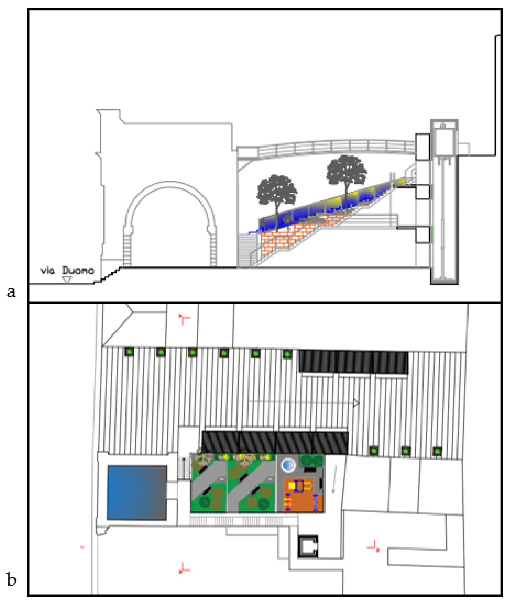
The project area on which it was decided to intervene in the workshop activities concerns the steps of Via Duomo, with particular reference to the small hanging garden that is located about halfway along the route, adjacent to the “Quarto Nobile”. This space, which was the subject of an intervention in 2013, is separated from the steps by a two-meter-fifty high wall, whose only access point is a small gate on the steps, is divided into three levels connected by stairs with flowerbeds and a small fountain. The original design idea was probably to restore a public green area, with some technical spaces in the volumes resulting from the change in height. In reality today the access gate is always closed and the wall clearly separates it from the path of the steps, blocking the view of the hanging gardens, which are mostly made up of small flowerbeds of uncultivated greenery.
It is also noted that the spaces of both the “ Quarto Nobile “ and the hanging garden are completely inaccessible to those with mobility difficulties.
The project therefore aims to give back to the community a space that is currently closed and inaccessible.
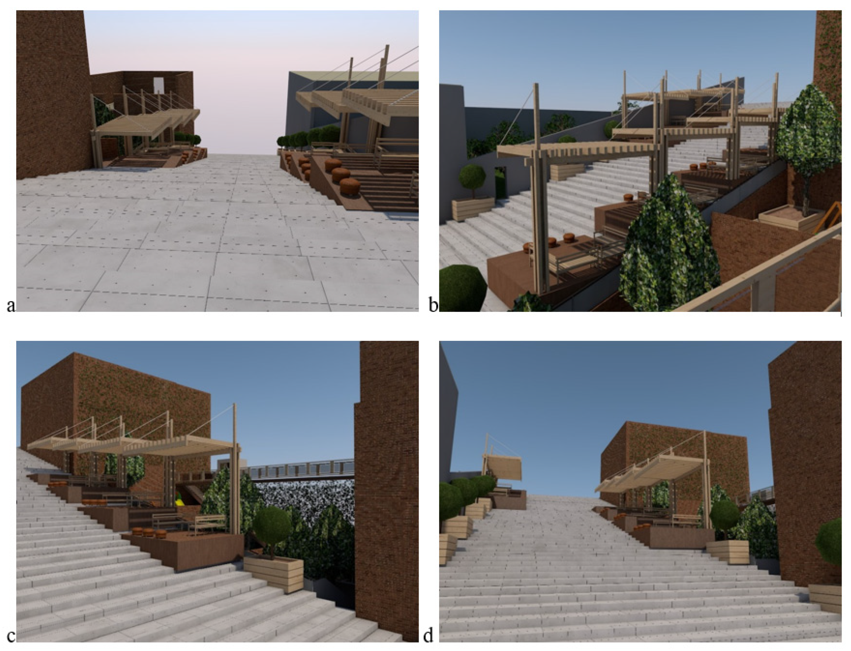
In order to identify some design references for which to draw inspiration, some examples of projects created to enhance urban spaces similar to the steps of Via Duomo were identified. These references were used to understand which functions and services could be integrated to improve the comfort and livability of the steps in the winter and summer seasons. Following the environmental analysis, some removable wooden shelters with removable platforms were designed, in order to create rest areas along the steps where people could shelter from the sun and where they could find comfortable seats to converse. The shelters with platforms are located in correspondence with the hanging garden, constituting almost an “extension” or an “invitation”, as the existing dividing wall, in the project is eliminated and replaced by a glass parapet that allows the visual and functional continuity of the spaces.
From the staircase there is direct access to the hanging garden which is enriched with greenery and furnished with seats, a children’s play area, a drinking water point and a fountain with a water feature. Accessibility is guaranteed by an oil-dynamic lift that starts from the level of Via Dante and allows access to the various levels. At the highest level of the garden, an aerial walkway in wood and glass allows you to reach the panoramic area of the noble quarter, from which you can enjoy the view of the entire valley.
The choice of natural materials, such as wood and glass, aims to achieve greater integration of the intervention into the historical urban context. The possibility of dismantling the platforms and shelters, which can be stored in the existing technical rooms under the hanging gardens, allows the use of the staircase not to be altered during the processions and religious events that take place annually, maintaining its image and functionality intact.
Outside the green area of Via Teatro Vecchio, a fountain and benches shaded by a flowerbed and a flowered shelter are inserted. Higher up, where the upper staircase continues after Via Archeologica, the pedestrian space is enriched with similar coherence by the addition of a small fountain and a flowerbed positioned on the left under the staircase.
The 2D architectural drawings and 3D model views of the designed intervention are reported in
Figure 19 and
Figure 20, respectively.
5. Conclusions
The NARO project aimed to experiment with an “alternative green policy”, testing models and technological systems based on the adoption of a biophilic approach, capable of improving the comfort of urban space, health and well-being of inhabitants.
For greening operations, interactions between the use of forms, materials and technologies came into play through which it is possible to identify “weak mitigation” works identified on the basis of performance indicators, environmental parameters and functional requirements. This led to the experimentation of interconnected networks of green spaces and blue infrastructures at the scale of the urban environment and technological solutions at the building scale: roof gardens and garden walls.
In this context, the progress of research has made it possible to reach an important critical mass on the topic and to develop, in an incremental manner, each area of the different contexts of action, from the environmental context to the urban space, up to the street furniture product designed according to an advanced logic with respect to the basic need-performance analysis.
In parallel, the urban greening process aimed to evaluate the intrinsic potential of regenerative ecological design approaches to create the necessary and timely changes in improving outdoor and indoor performance.
A first positive assessment of the research opens up new perspectives of interdisciplinarity and at the same time highlights its limits and critical issues. If on the one hand the aim of the research was to test replicable biophilic design solutions, on the other hand it was understood how it is necessary to cultivate greater areas of sharing with the ecology sectors, exploiting the individual strengths to project oneself into a future of change in continuous and sensitive symbiosis with nature [
17].
The greater presence of greenery, the attention to accessibility routes, the presence of shaded rest areas and children’s play areas, in fact allow the improvement of the livability of the spaces by the citizen, meeting the needs that have been identified.
The biophilic approach adopted in the design of spaces and in the integration of the new into the existing context, aims to give a concrete contribution to the improvement of urban comfort, also enhancing the quality of public spaces through the design of greenery.
Author Contributions
For research articles with several authors, a short paragraph specifying their individual contributions must be provided. The following statements should be used “Conceptualization, T.F., F.F, R.V. and E.G.; methodology, T.F., F.F, R.V. and E.G.; software, F.Z.; investigation, T.F., F.F, R.V. and E.G.; data curation, T.F., F.F, R.V. and E.G. and F.Z.; writing—original draft preparation, T.F., F.F, R.V. and E.G. and F.Z.; writing—review and editing, T.F., F.F, R.V. and E.G. and F.Z.; visualization, T.F., F.F, R.V. and E.G. and F.Z. All authors have read and agreed to the published version of the manuscript. Chapters and paragraphs authorship: 1. T.F., F.F. and R.M.V.; 1.1 and 1.2 (1.2.1, 1.2.2, 1.2.3, 1.2.4) T.F.; 2 and 2.1 R.M.V.; 3. F.Z.; 4.1 E.G.; 4.2 F.Z.; 4.3 R.M.V.; 4.4 F.F.; 5 R.M.V. and F.F.
Funding
This research was funded by “Piano straordinario dell’Università degli Studi di Palermo per il miglioramento della qualità della ricerca e dei risultati della VQR 2020-2024, fondo PJ_UTILE_2022_VQR_MISURA_B_D01_NICOLINI”.
Data Availability Statement
No more data are available.
Acknowledgments
We would like to acknowledge all the students participating in the “Workshop Naro” on the environmental design object of this study: Grammauta Fabio, Lucchese Caterina, Pizzo Gianluca, and Tomasello Giuseppe. We also would like to acknowledge professor Elvira Nicolini for the “Workshop Naro”organization.
Conflicts of Interest
The authors declare no conflicts of interest.
References
- Vitrano, R.M. Transition Management Spheres: nature—Based solutions. In Fatiguso F., Fiorito F., De Fino M., Cantatore E., Gorizia. Colloqui.AT.e 2023: Transition: challenges and opportunities for the build heritage, EdicomEdizioni, 2023, 1923-1940, ISBN: 979-12-81229-02-0.
- Gehl, J. (1971), Life between buildings. Using public space, Danish Architecture Press, Island Press, Washington DC.
- Dessì, V., Progettare il comfort urbano, Simone editore, Napoli, 2007.
- Fra’ Saverio Cappuccino, Naro antico, (manuscript 1800), Biblioteca Feliciana di Naro, 1971. S.C. 13.
- Pitruzzella, S. Naro: arte, storia, leggenda, archeologia; Scuola tip. R. Istituto d’assistenza: Palermo, Italy, 1938; Spatrisano, G. Lo Steri di Palermo e l’architettura siciliana del Trecento; S. F. Flaccovio: Palermo, Italy, 1972; pp. 214-217.
- Emanuele Gaetani, F. M. Della Sicilia nobile; anastatic reprint of the ed. Stamperia de’ Santi Apostoli: Palermo, Italy, 1754-1775); Forni: Sala Bolognese, Italy, 1986; Libro IV, p. 21.
- Garofalo, E.; Nobile, M. R. Cent’anni di solitudine? L’architettura dei Chiaromonte in Sicilia tra storiografia e nuove prospettive. In Chiaromonte. Lusso, prestigio, politica e guerra nella Sicilia del Trecento. Un restauro verso il futuro; Di Natale, M. C., Nobile, M. R., Travagliato, G., Eds.; Palermo University Press: Palermo, Italy, 2020, pp. 55-68.
- Vallery-Radot, J. Le recueil de plans d’édifices de la Compagnie de Jésus conservé à la Bibliothèque Nationale de Paris; Institutum Historicum S.I. : Roma, Italy, 1960, pp. 55-56.
- Lima, A. I. Architettura e urbanistica della Compagnia di Gesù in Sicilia. Fonti e documenti inediti, secoli XVI-XVIII; Novecento: Palermo, Italy, 2001, pp. 240-244.
- Coniglione, M.A. La provincia Domenicana di Sicilia; Tip. F. Strano: Catania, Italy, 1937, p. 370.
- Alessi, B. Naro: guida storica e artistica; Centro culturale L. Pirandello: Agrigento, Italy, 1976, p. 99.
- Climate Consultant software. https://www.sbse.org/resources/climate-consultant [last access 1 October 2024].
- Weatherspark Naro climate data. https://it.weatherspark.com/ [last access 1 October 2024].
- Koppen Geiger tool. https://koppen.earth/ [last access 1 October 2024].
- Decreto del Presidente della Repubblica 26 agosto 1993, n. 412. Regolamento recante norme per la progettazione, l’installazione, l’esercizio e la manutenzione degli impianti termici degli edifici ai fini del contenimento dei consumi di energia, in attuazione dell’art. 4, comma 4, della legge 9 gennaio 1991, n. 10.
- Google Earth tool. https://earth.google.com/ [last access 1 October 2024].
- Shadowmap tool. https://app.shadowmap.org/ [last access 1 October 2024].
- Vitrano, R.M. Naturally available solutions for building new metabolic territories. In SMC Sustainable Mediterranean Construction, 2021, vol. 14, p. 141-148, Napoli: Luciano Editore; ISSN: 2420-8213.
Figure 1.
Examples of green solutions (left), grey solutions (middle) e blue solutions (right).
Figure 1.
Examples of green solutions (left), grey solutions (middle) e blue solutions (right).
Figure 2.
Incidence of solar radiation in different urban spaces.
Figure 2.
Incidence of solar radiation in different urban spaces.
Figure 3.
a. Plaza de Armas, Santiago, Chile; b. Plaza de Armas, Madrid, Spain; c. Canopy in the old port of Marsiglia, France, by architect N. Foster, 2013; d. Metropol Parasol Siviglia,Spain. By architect J. Mayer H., 2011; e. Maxi-tent made with crochet to protect the streets from the summer heat, Alhaurín de la Torre, Malaga, Spain; f. Covered market of Ballarò, Palermo, Italy.
Figure 4.
a. Green barriers at different heights; b. Deflectors made of steel frames covered with perforated aluminium to reduce wind speed, Bridgewater Place, Leeds, England, 2005.
Figure 4.
a. Green barriers at different heights; b. Deflectors made of steel frames covered with perforated aluminium to reduce wind speed, Bridgewater Place, Leeds, England, 2005.
Figure 5.
a. Cool pavement; b. Hot pavement ; c. Combined pavement.
Figure 5.
a. Cool pavement; b. Hot pavement ; c. Combined pavement.
Figure 7.
Top left the Superillas in Madrid, right the Caixa Foum in Madrid by Patrick Blanc, bottom the project in Vitoria-Gasteiz, Spain.
Figure 7.
Top left the Superillas in Madrid, right the Caixa Foum in Madrid by Patrick Blanc, bottom the project in Vitoria-Gasteiz, Spain.
Figure 8.
Design didactic method adopted.
Figure 8.
Design didactic method adopted.
Figure 9.
View from the castle of the old mother church in Naro.
Figure 9.
View from the castle of the old mother church in Naro.
Figure 10.
a. View of the remains of the monastery of Benedictine nuns called “Quarto Nobile” and of the façade; b. View of the old mother church; c. View of the stairway connecting the old mother church with Via Dante.
Figure 10.
a. View of the remains of the monastery of Benedictine nuns called “Quarto Nobile” and of the façade; b. View of the old mother church; c. View of the stairway connecting the old mother church with Via Dante.
Figure 11.
a. Satellite view of Naro municipality; b. Satellite view of the project site.
Figure 11.
a. Satellite view of Naro municipality; b. Satellite view of the project site.
Figure 12.
Weather data of Naro: a. Air temperatures; b. People comfort due to RH; c. Rainfalls; d. Wind speed.
Figure 12.
Weather data of Naro: a. Air temperatures; b. People comfort due to RH; c. Rainfalls; d. Wind speed.
Figure 13.
a. 3D Satellite view of the project site; b. Street view from the top of the project site.
Figure 13.
a. 3D Satellite view of the project site; b. Street view from the top of the project site.
Figure 14.
a. Sunchart of the project site in 4 exemplary daily times: a.9 AM; b. 12 AM; c. 5 PM; d. 8 PM.
Figure 14.
a. Sunchart of the project site in 4 exemplary daily times: a.9 AM; b. 12 AM; c. 5 PM; d. 8 PM.
Figure 15.
Via Duomo—the green perspective: an integrated vision for Naro.
Figure 15.
Via Duomo—the green perspective: an integrated vision for Naro.
Figure 16.
Greening of Via Duomo: analysis of building curtains and use of green technology.
Figure 16.
Greening of Via Duomo: analysis of building curtains and use of green technology.
Figure 17.
Greening of Via Duomo: section of the “Quarto Nobile”: fences, thresholds, borders.
Figure 17.
Greening of Via Duomo: section of the “Quarto Nobile”: fences, thresholds, borders.
Figure 18.
Greening of Via Duomo: Rain Garden, roof garden and garden walls.
Figure 18.
Greening of Via Duomo: Rain Garden, roof garden and garden walls.
Figure 19.
Architectural drawings of preliminary renovation design.
Figure 19.
Architectural drawings of preliminary renovation design.
Figure 20.
3D model of the preliminary renovation design made by the student F. Grammauta: a. View of the staircase from the top; b. View of the staircase from the inner garden; c. View of the inner garden from the staircase; d. View of the staircase from below.
Figure 20.
3D model of the preliminary renovation design made by the student F. Grammauta: a. View of the staircase from the top; b. View of the staircase from the inner garden; c. View of the inner garden from the staircase; d. View of the staircase from below.
|
Disclaimer/Publisher’s Note: The statements, opinions and data contained in all publications are solely those of the individual author(s) and contributor(s) and not of MDPI and/or the editor(s). MDPI and/or the editor(s) disclaim responsibility for any injury to people or property resulting from any ideas, methods, instructions or products referred to in the content. |
© 2024 by the authors. Licensee MDPI, Basel, Switzerland. This article is an open access article distributed under the terms and conditions of the Creative Commons Attribution (CC BY) license (http://creativecommons.org/licenses/by/4.0/).
