
Submitted:
29 June 2024
Posted:
01 July 2024
Read the latest preprint version here
Abstract
This study explores the potential of digital technologies for preserving cultural heritage through the case study of the Raya Gopura, an incomplete monument in Melukote, India. Employing a combination of terrestrial photogrammetry, drone-based photogrammetry and terrestrial laser scanning, the research team captured highly detailed 3D models of the structure. This non-destructive approach offers a comprehensive digital record for future research and preservation. Furthermore, for the conjecture for the Raya Gopura two possible purposes: an entrance to a planned fort or a gateway to the temple are perceived through the collective intelligence (CI) approach. These insights inform a conjectural architectural drawing of the potentially completed monument. The 3D models hold significant potential for various applications, including tourism, education, and architectural research, with the potential for immersive experiences through VR and AR technologies. The study demonstrated the effectiveness of digital tools in heritage preservation, not only safeguarding the Raya Gopura but also offering valuable in-sights for future research and public engagements.
Keywords:
Digital Documentation
; Photogrammetry
; UAV
; Cultural Heritage
; Architecture
; LiDAR
; Reality Capture
1. Introduction
The cultural heritage of humanity encompasses a vast array of structures, monuments, and artifacts, each holding immense historical and artistic significance. Preserving these treasures for future generations necessitates innovative approaches that transcend traditional methods [1]. This paper explores the transformative potential of digital technologies in heritage documentation, focusing on a specific case study: the Raya Gopura, an incomplete historical structure of the Melukote, of Karnataka Stata in India.
This research investigates the application of photogrammetry and Light Detection & Ranging (LiDAR) based techniques for the comprehensive digital documentation of the Raya Gopura. By employing a combination of terrestrial and drone-based photogrammetry alongside terrestrial laser scanning, the study achieves highly detailed and realistic 3D models of the monument [2,3]. This methodology offers several advantages over conventional documentation methods. Firstly, it provides a non-destructive approach, safeguarding the physical integrity of the structure. Secondly, the resulting digital representations offer exceptional accuracy and detail, enabling in-depth analysis and future research endeavours.
Beyond mere documentation, this study delves into the historical context of the Raya Gopura. Through consultations with experts and scholars, the research team formulates two potential purposes for the monument’s construction: as the entrance to a planned fort or as the gateway to a revered temple. These insights not only illuminate the significance of the Raya Gopura but also shed light on the architectural and cultural nuances of Vijayanagara-era structures.
Furthermore, the generated 3D models possess immense potential for various applications. Design thinking has been enhanced by collective intelligence (CI), which produces prospective designs. CI has been more prominent in recent times [4]. These digital resources can be utilized in tourism promotion, educational programs, and architectural research [5]. Additionally, the integration of virtual and augmented reality (VR/AR) technologies opens doors for virtual heritage (VH) through immersive experiences, fostering a deeper public engagement with cultural heritage [6,7].
Overall, this paper highlights the efficacy of digital technologies in heritage preservation. The Raya Gopura case study demonstrates the power of the integration of photogrammetry and LiDAR in creating comprehensive 3D models that not only safeguard cultural treasures but also unlock new avenues for research, education, and public appreciation [8]. This study paves the way for continued exploration of digital tools in heritage documentation, ensuring the enduring legacy of our cultural heritage for generations to come.
2. Study Area
The study area for this project is Melukote, a sacred town nestled in the Yadugiri hills of Karnataka, India is a historically significant town known for its rich cultural and religious heritage. It is renowned for the Cheluvanarayana Swamy Temple, which dates back to the Hoysala period in the 12th century. The town gained prominence under the patronage of the Hoysala kings, particularly Vishnuvardhana, and later flourished under the Vijayanagara Empire. The philosopher and theologian Ramanujacharya spent several years here in the 12th century, which further elevated its religious importance among the Sri Vaishnavas. Melukote is also noted for its traditional festivals, such as Vairamudi, and its unique contributions to South Indian art and architecture, featuring intricate carvings and well-preserved ancient structures.
The monument of interest is the Raya Gopura, an unfinished gateway located on the Yadugiri hills, about 100 meters south of the Cheluvanarayana Swamy temple as shown in Figure 1. Local chronicles attribute its construction to Gopala Raya, while another narrative suggests it was envisioned as the entrance to a large fort by Chief Timmanna Dannayaka. The Raya Gopura is built with granite and features intricate carvings, but its upper section remains unfinished with piles of scattered granite slabs.
3. Materials and Methods
The historical significance of the Raya Gopura draws numerous tourists who appreciate its architecture and its prominent location at an elevated site. Photogrammetry serves as the fundamental principle for the various surveying methods applied, offering an extensively utilized technique for capturing, documenting, and interpreting data to acquire accurate measurements and other essential details. The surveying process employed three primary devices: a camera, a terrestrial laser scanner, and a drone. Subsequently, this description delves into the specifics of the capturing techniques and the devices used in the survey.
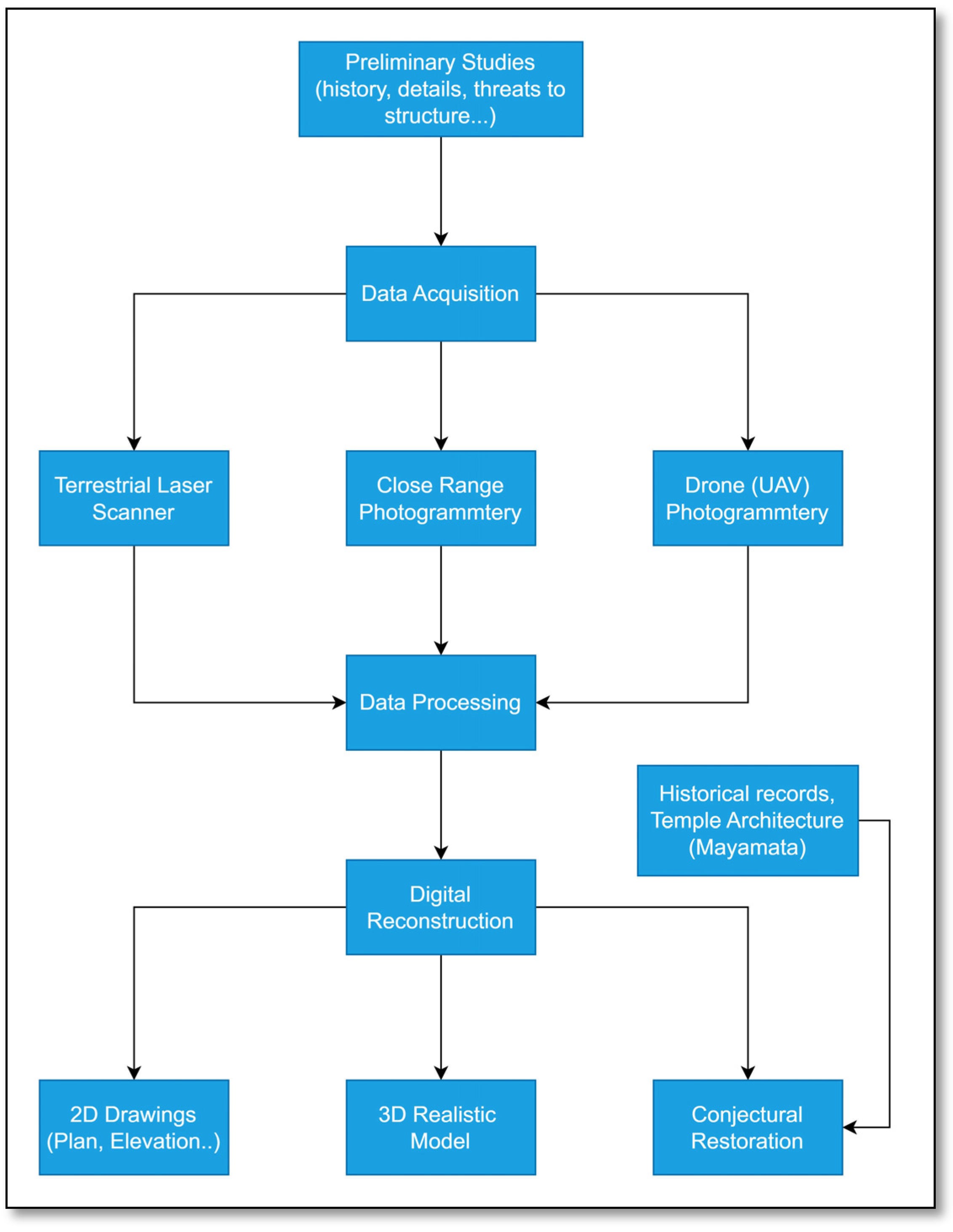
Figure 2.
Flowchart of the methodology used for the digital reconstruction of the Raya Gopura monument.
Figure 2.
Flowchart of the methodology used for the digital reconstruction of the Raya Gopura monument.
Close Range Photogrammetry
Utilizing a terrestrial camera positioned either handheld or fixed on the ground, photos were captured from a fixed ground position, ensuring the camera’s axis was parallel to the Earth’s surface. The project employed a Sony A73 camera equipped with a 16-35 mm F4 Zeiss lens, boasting 24 MP, a full-frame Mirrorless configuration, a minimum focus distance of 0.28m (0.92ft), a maximum magnification ratio of 0.19x, and built-in Optical SteadyShot™ Image Stabilization (OSS). The camera’s coordinates and additional metadata were recorded at the moment of each shot. It’s essential to note that terrestrial photogrammetry, in this context, is non-topographic, focusing on the arrangement of physical characteristics of the monument rather than the topography of the area [9,10]. The process involved capturing nearly two thousand photos, encompassing various angles and distances, meticulously covering all parts of the monument for comprehensive detail. Following the capture phase, the data underwent processing in Adobe Lightroom. This involved the elimination of shadows and the implementation of basic colour corrections (saturation, brightness, contrast, exposure, etc.). To ensure accuracy in the later stages of data processing, the datasets were meticulously organized into different file folders.
Aerial Photogrammetry
This method involved the adoption of two approaches: automated mission planning for the site and manual operation of the drone to capture the roof and upper features of the monument. Through automated flight planning, the drone systematically collected data for the selected area, ensuring a 70% forward overlap and 35% side overlap, resulting in 250 geotagged photos [11]. Simultaneously, to document the upper part of the monument manually, approximately 1500 overlapping photos were consistently captured. The amalgamation of these two datasets significantly enhanced accuracy during the processing phase[12,13]. The drone employed for this project was the PHANTOM 4 PRO, equipped with a 1″ CMOS Camera Sensor boasting 20M effective pixels. The lens featured an 84° FOV, with focal lengths of 8.8 mm and 24 mm (35 mm format equivalent). The obtained image size was 4:3 Aspect Ratio at 4864 × 3648. The data collected underwent processing in Agisoft Metashape Professional.
Terrestrial Laser Scanner
The terrestrial laser scanner stands as a high-precision surveying instrument designed for capturing intricate three-dimensional (3D) data of objects, structures, or landscapes on the Earth’s surface [14]. This advanced tool relies on laser technology to measure the distance and position of points within its field of view, ultimately creating a point cloud representation of the scanned area. The introduction of terrestrial laser scanners has marked a significant advancement in the realm of 3D data capture, delivering precise and detailed depictions of real-world environments [15]. Consequently, these scanners have become indispensable in industries requiring accurate measurements and comprehensive documentation of objects and landscapes. The LiDAR instrument employed in this project is the Faro Focus 3D S350 Plus Terrestrial Laser Scanner, featuring a range focus from 0.6 to 350 meters, a measurement speed of up to 976,000 points per second (or up to 2 million points per second), an angular accuracy of 19 arcsecs for vertical/horizontal angles, and an integer colour camera with a resolution of up to 165 million pixels.
Data Processing
The preprocessed data is systematically organized and imported into Capturing Reality software. Within the domain of Cultural Heritage, this software plays a crucial role in facilitating accessibility to heritage for everyone, ranging from scanning small museum objects to historic sites, and from generating digital replicas to constructing virtual heritage. The processing stages involved in obtaining the 3D model encompass alignment, mesh reconstruction, texturing, and simplification [16].
Alignment
The software scrutinizes the camera position at the moment an image is captured, a determination facilitated by the interior and exterior orientation parameters at this stage. Following alignment, two distinct components were derived, a consequence of insufficient overlap in specific areas. To address this, 5 control points were employed, each associated with a minimum of 10 photos in all three different data sets, ensuring alignment of all 4500 images from the various data sets. The resultant master component comprises all 4500 images represented as a sparse point cloud.
Mesh Reconstruction
The software can reconstruct polygonal mesh models utilizing depth map data or point cloud data, encompassing dense, sparse, and point cloud data imported from external sources. Depth maps generated are employed to formulate a 3D mesh using photos as input. A 3D range grid is back-projected onto each depth map, and by connecting nearby vertices on the grid, a preliminary mesh is generated [17]. All vertices from the depth maps are amalgamated and input into the reconstruction method. This approach yields a triangulated surface that is impervious. The reconstruction algorithm assumes a complete, closed surface, and it fills in low-point density regions with multiple triangles. The reconstruction process under Normal Mode spanned approximately 4 days, resulting in a mesh comprising about 1.2 billion triangles.
Texturing and Simplification
Texturing is the further step done to achieve a realistic appearance of the model. Initially, the model comprised 1.2 billion triangles, posing challenges for practical use. To address this complexity, the Simplification tool was employed iteratively, reducing it by 50% in each cycle. After multiple iterations, the model was successfully reduced to 1 million triangles. Rapidly reducing triangles in a single step can significantly impact the model’s resolution and quality. To counteract this, the Reprojection tool projects the original texture onto the simplified model, preserving quality with minimal size changes [18].
Scan to CAD
The orthographic projections generated through the Capturing Reality software were brought into AUTOCAD software for the drafting process. The necessary plans, sections, and elevations were meticulously drafted using the rendered orthographic projections. These drafted components exhibit exceptional accuracy as they originate from a scaled and resized model of the real heritage structure. The dimensions of these elements can be precisely measured. Subsequently, the drafted elements are exported in the designated file format based on the intended future use of the drawings [19].
3. Results
The comprehensive methodology employed in the survey and documentation of the Raya Gopura historical site has yielded a detailed and accurate representation of the monument. Photogrammetry served as the foundational technique, utilizing a Sony A73 camera to capture nearly two thousand photos from various angles and distances. These images underwent meticulous processing in Adobe Lightroom, where shadows were eliminated, and colour corrections were applied to ensure high-quality data. The terrestrial photogrammetry approach facilitated the creation of a non-topographic dataset, offering a thorough depiction of the monument’s architectural details [20].
Furthermore, the integration of drone technology played a crucial role in enhancing the surveying process [13,21]. An automated mission planning strategy and survey details are shown in Table 1, coupled with manual drone operation, resulted in the acquisition of 231 geotagged photos with 70% forward overlap and 35% side overlap, along with an additional 1500 manually captured images focusing on the upper features of the monument. Figure 3 depicts the camera locations and image overlap of the aerial survey conducted using flight planning. The PHANTOM 4 PRO drone, equipped with a 1″ CMOS camera sensor, provided the necessary data for processing in Agisoft Metashape Professional, ultimately contributing to a more accurate and comprehensive dataset [22]. The 231 images were processed and an orthoimage as shown in Figure 4.
The incorporation of terrestrial laser scanning, facilitated by the Faro Focus 3D S350 Plus Terrestrial Laser Scanner, brought a new dimension to the survey methodology. This high-precision instrument generated a detailed point cloud representation of the scanned area, with a maximum point error of 18.3 mm and a mean point error of 9.8 mm as shown in Figure 5. The LiDAR data was processed using FARO SCENE 2018 software, adding another layer of precision to the overall dataset.
The subsequent stages of data processing, conducted in Capturing Reality software, involved alignment, mesh reconstruction, texturing, and simplification. Figure 6a depicts the camera positions of aerial and terrestrial camera after the alignment step. The 3D model obtained, comprising 1.2 billion triangles, underwent a meticulous reduction process to improve manageability. The reconstruction algorithm, operating under Normal Mode, created a triangulated surface, and texturing was applied with a maximal count of 25 and a fixed texel size of 0.02m. The resulting model, which was initially intricate and challenging to work with, was iteratively simplified, reaching a manageable size of 1 million triangles while preserving its realistic texture as shown in Figure 6b.
The culmination of this research effort involved rendering orthographic projections to scale and importing them into AutoCAD for the creation of architectural drawings, including plans, and front and side elevations as shown in Figure 7a and Figure 8a,b. The comprehensive results obtained from this methodology provide a valuable resource for preserving and studying the architectural heritage of the Raya Gopura historical site, ensuring accessibility and understanding for generations to come.
Figure 9 illustrates the geographical positioning of two significant landmarks in Melukote, Karnataka, as viewed on a Google Earth image. The locations are marked as follows: (A) Sri Cheluvanarayana Swamy Temple, a prominent and historical temple central to Melukote’s cultural heritage, and (B) Raya Gopura, an unfinished yet majestic structure that exemplifies the architecture of the Vijayanagara period. The image highlights the spatial relationship between these landmarks, providing a visual context for their historical and cultural significance within the town.
The incomplete nature of the Raya Gopura prompted an analysis of completed structures, such as the Gopura of Yoga Narasimha Svami Temple in Melukote, the entrance of Bangalore fort, and others, to comprehend Vijayanagara Era Gopuras. After consultations with history experts and scholars in South Indian Temple Architecture, two conjectural conclusions emerged. Firstly, the Raya Gopura could have been the entrance to the planned fort of Melukote, aligning with the existing Hoysala ruins. Secondly, it may have served as the gateway to the Great Temple of Sri Cheluvanarayana Swamy, given the town’s sacred significance as shown in Figure 9. The presence of shrines near gateways supports the former, while the latter aligns with the historical importance of the temple.
Both conclusions suggest that the Raya Gopura acted as a Mahadvara or main gate, symbolizing its importance. The comparisons of Raya Gopura with other temple towns like Madurai, Sri Rangam, Thanjavur, etc reveal a potential integration of the entire town within the temple walls or fort, emphasizing the importance of the monument. Informed by these insights, a conjectural architectural drawing of the planned Raya Gopura was visualized and drafted, incorporating seven tiers, representing both architectural considerations and symbolic representations, as per ancient treatises like the Mayamata as shown in Figure 10. This study not only contributes to understanding the Raya Gopura but also provides valuable insights into the architectural and cultural nuances of Vijayanagara-era structures
4. Discussion
This Raya Gopura monument presents a unique case study for the digital documentation heritage using photogrammetric and remote sensing techniques. This unfinished monument is of historical significance and offers valuable insights into Vijayanagara-era architectural practices as well as the cultural landscape of Melukote. Overall the research employed a multi-pronged approach, combining terrestrial photogrammetry, drone-based photogrammetry and terrestrial laser scanning (TLS) to generate highly detailed 3D models of the Raya Gopura. This non-destructive methodology provides a permanent digital record of the monument’s current state, surpassing the limitations of traditional documentation methods such as manual measurements and drawings.
The resulting 3D models offer exceptional geometric accuracy and facilitate in-depth analysis of the monument’s architectural details. The unfinished monument is completed using conjecture based on architectural comparisons with other Vijayanagara-era gopuras. This conjectural reconstruction can shed light on the original design intent and provide valuable insights for future conservation activities.
Furthermore, the 3D models hold immense potential for various scientific applications. High-resolution texture mapping can be employed to document and analyze the surface ornamentation and carvings on the Raya Gopura. This data can be instrumental in studying the iconography and symbolism prevalent in Vijayanagara architecture. Additionally, the 3D models can be integrated with Building Information Modeling (BIM) software to create a comprehensive digital twin of the Raya Gopura. This HBIM (Historic—Building Information Model) model can be used for structural analysis, vulnerability assessment, and potential seismic risk mitigation strategies [23,24].
Beyond scientific applications, the digital documentation of the Raya Gopura opens doors for broader public engagement with cultural heritage. The 3D models can be disseminated online through virtual museums or interactive platforms, allowing viewers to explore the monument in detail from anywhere in the world. Additionally, immersive technologies like Virtual Reality (VR) and Augmented Reality (AR) can be utilized to create interactive experiences that bring the Raya Gopura to life. These experiences can foster a deeper appreciation for the monument’s historical and cultural significance, particularly for younger generations and tourists.
While this study demonstrates the effectiveness of digital documentation techniques, some limitations are acknowledged. The accuracy of the 3D models is contingent upon factors like drone flight path planning and the quality of the TLS point cloud data [25]. Additionally, the virtual reconstruction of the complete Raya Gopura is inherently conjectural and relies on architectural comparisons with existing structures. Future research directions can involve collaborations with temple architects and archaeologists to refine the virtual reconstruction based on historical and archaeological evidence. Furthermore, integrating material science analysis with the digital models can provide insights into the deterioration processes affecting the Raya Gopura and inform future conservation efforts.
5. Conclusions
The study on the digital documentation and preservation of the heritage structure, particularly focusing on the Raya Gopura in Melukote, has illuminated significant insights into the application as well as the utility of advanced non-destructive methods for digital reconstruction and conjectural restoration. Through the utilization of photogrammetry and LiDAR-based techniques, successful documentation of the Raya Gopura was done, providing a highly detailed and realistic 3D model without compromising the structure’s integrity. Based on the collective intelligence (CI) while exploring the historical context of the Raya Gopura, two conjectural conclusions regarding its purpose are drawn. The purpose can either be as the entrance planned for the fort of Melukote or could have been the gateway to the Sri Cheluvanarayana Swamy Temple. Both scenarios underline the monumental significance of the Raya Gopura, emphasizing its role as a vital historical and cultural artefact.
Furthermore, the research has demonstrated the versatility of the acquired 3D models, offering immense potential for future studies. These digital representations can be leveraged in diverse fields, such as tourism promotion, educational initiatives, and architectural research. The integration of Virtual Reality (VR) and Augmented Reality (AR) technologies opens avenues for immersive experiences, fostering a deeper understanding and appreciation of cultural heritage. The methodology employed in this study, encompassing terrestrial photogrammetry, drone-based surveys, and terrestrial laser scanning, showcases the importance of interdisciplinary approaches in heritage documentation. The amalgamation of these technologies has allowed for the creation of a comprehensive digital record that transcends traditional preservation methods.
Looking ahead, the scope for future studies in this domain is expansive, such 3D models can be pivotal in advancing research, education, and cultural awareness. As technology continues to evolve, the dynamic state of image-based 3D documentation presents exciting prospects, promising even more sophisticated applications in the preservation and study of our rich cultural heritage. In essence, this research not only contributes to the understanding of the Raya Gopura but also serves as an example of the efficacy of cutting-edge digital documentation methods in the broader context of heritage preservation. The knowledge gained from this study paves the way for continued exploration and appreciation of our historical treasures.
Author Contributions
S. M. and P. N. P. carried out the fieldwork i.e., capturing the data using a camera and drone; N. U. guided throughout the project and contributed a few sections in the manuscript; A. B. has contributed to the analysis of data and manuscript preparation through his valuable insights. All the authors have read and agreed to the published version of the manuscript.
Funding
There was no funding received.
Data Availability Statement
Camera and Drone data was self-acquired by the authors.
Acknowledgments
We are grateful to the Department of Archaeology, Museums and Heritage, Mysuru of Karnataka Government for providing permission to their protected site. We are indeed grateful to the Karnataka State Council for Science and Technology, especially Dr. Vijay U. T. for providing the TLS data which was extremely beneficial to the study.
Conflicts of Interest
The authors declare no conflicts of interest.
References
- M. Pfarr-Harfst, “Typical workflows, documentation approaches and principles of 3D digital reconstruction of cultural heritage,” in Lecture Notes in Computer Science (including subseries Lecture Notes in Artificial Intelligence and Lecture Notes in Bioinformatics), Springer Verlag, 2016, pp. 32–46. [CrossRef]
- E. Donato and D. Giuffrida, “Combined methodologies for the survey and documentation of historical buildings: The castle of scalea (cs, italy),” Heritage, vol. 2, no. 3, pp. 2384–2397, Sep. 2019. [CrossRef]
- S. Muralidhar and A. Bhardwaj, “Application of UAV Data in Mapping and Visualization of Heritage site: A case study of Manjarabad Fort, Karnataka,” in ISRS-ISG National Symposium on “Geospatial Technology: Journey from Data to Intelligence, ISRS, Nov. 2022.
- P. Murty and M. Paulini, “Collective Intelligence and Design Thinking,” Design Thinking Research Symposium 8, 2010. [Online]. Available: https://api.semanticscholar.org/CorpusID:4849060.
- C. G. Marques, J. P. Pedro, and I. Araújo, “A Systematic Literature Review of Gamification in/for Cultural Heritage: Leveling up, Going Beyond,” Heritage, vol. 6, no. 8. Multidisciplinary Digital Publishing Institute (MDPI), pp. 5935–5951, Aug. 01, 2023. [CrossRef]
- E. M. Champion, Virtual Heritage: A Guide. London: Ubiquity Press, 2021. [CrossRef]
- J. Zhao, J. O. Wallgrün, P. C. LaFemina, J. Normandeau, and A. Klippel, “Harnessing the power of immersive virtual reality—visualization and analysis of 3D earth science data sets,” Geo-Spatial Information Science, vol. 22, no. 4, pp. 237–250, Oct. 2019. [CrossRef]
- Y. J. Hoon and S. Hong, “Three-dimensional digital documentation of cultural heritage site based on the convergence of terrestrial laser scanning and unmanned aerial vehicle photogrammetry,” ISPRS Int J Geoinf, vol. 8, no. 2, Jan. 2019. [CrossRef]
- J. Moyano, J. E. Nieto-Julián, D. Bienvenido-Huertas, and D. Marín-García, “Validation of Close-Range Photogrammetry for Architectural and Archaeological Heritage: Analysis of Point Density and 3D Mesh Geometry,” Remote Sens (Basel), vol. 12, no. 21, 2020. [CrossRef]
- S. D’Amelio and M. Lo Brutto, “Close range photogrammetry for measurement of paintings surface deformations,” International Archives of the Photogrammetry, Remote Sensing and Spatial Information Sciences, vol. 38, Sep. 2009.
- S. Muralidhar, H. Mulay, and A. Bhardwaj, “UAV-Based 3D Mapping and Digital Documentation for Heritage Preservation: Chitradurga Fort, Karnataka,” in 3rd International Conference on Unmanned Aerial System in Geomatics—2023, Malaysia, Nov. 2023.
- F. Nex and F. Remondino, “UAV for 3D mapping applications: a review,” Applied Geomatics, vol. 6, no. 1, pp. 1–15, 2014. [CrossRef]
- E. Karachaliou, E. Georgiou, D. Psaltis, and E. Stylianidis, “UAV for MAPPING HISTORIC BUILDINGS: From 3D MODELLING to BIM,” ISPRS Annals of the Photogrammetry, Remote Sensing and Spatial Information Sciences, vol. 42, no. 2/W9, pp. 397–402, Jan. 2019. [CrossRef]
- B. Kwoczynska, U. Litwin, I. Piech, P. Obirek, and J. Sledz, “The Use of Terrestrial Laser Scanning in Surveying Historic Buildings,” Proceedings—2016 Baltic Geodetic Congress (Geomatics), BGC Geomatics 2016, pp. 263–268, Aug. 2016. [CrossRef]
- N. Yastikli, “Documentation of cultural heritage using digital photogrammetry and laser scanning,” J Cult Herit, vol. 8, no. 4, pp. 423–427, 2007. [CrossRef]
- S. Muralidhar and A. Bhardwaj, “Three-Dimensional Modelling and Visualization of Stone Inscriptions Using Close-Range Photogrammetry—A Case Study of Hero Stone,” Engineering Proceedings, vol. 27, no. 1, 2022. [CrossRef]
- X. quan Li, Z. an Chen, L. ting Zhang, and D. Jia, “Construction and Accuracy Test of a 3D Model of Non-Metric Camera Images Using Agisoft PhotoScan,” Procedia Environ Sci, vol. 36, pp. 184–190, 2016. [CrossRef]
- S. Hu, Z. Li, S. Wang, M. Ai, and Q. Hu, “A texture selection approach for cultural artifact 3D reconstruction considering both geometry and radiation quality,” Remote Sens (Basel), vol. 12, no. 16, Aug. 2020. [CrossRef]
- F. Remondino, “Heritage Recording and 3D Modeling with Photogrammetry and 3D Scanning,” Remote Sens (Basel), vol. 3, no. 6, pp. 1104–1138, 2011. [CrossRef]
- D. Moullou, R. Vital, S. Sylaiou, and L. Ragia, “Digital Tools for Data Acquisition and Heritage Management in Archaeology and Their Impact on Archaeological Practices,” Heritage 2024, Vol. 7, Pages 107-121, vol. 7, no. 1, pp. 107–121, Dec. 2023. [CrossRef]
- P. Martínez-Carricondo, F. Carvajal-Ramírez, L. Yero-Paneque, and F. Agüera-Vega, “Combination of nadiral and oblique UAV photogrammetry and HBIM for the virtual reconstruction of cultural heritage. Case study of Cortijo del Fraile in Níjar, Almería (Spain),” Building Research and Information, vol. 48, no. 2, pp. 140–159, Feb. 2020. [CrossRef]
- P. Tysiac, A. Sieńska, M. Tarnowska, P. Kedziorski, and M. Jagoda, “Combination of terrestrial laser scanning and UAV photogrammetry for 3D modelling and degradation assessment of heritage building based on a lighting analysis: case study—St. Adalbert Church in Gdansk, Poland,” Herit Sci, vol. 11, no. 1, p. 53, 2023. [CrossRef]
- S. A. G. Korumaz and F. Yildiz, “Positional accuracy assessment of digital orthophoto based on UAV images: An experience on an archaeological area,” Heritage, vol. 4, no. 3, pp. 1304–1327, Sep. 2021. [CrossRef]
- Y. Alshawabkeh, A. Baik, and A. Fallatah, “As-textured as-built bim using sensor fusion, zee ain historical village as a case study,” Remote Sens (Basel), vol. 13, no. 24, Dec. 2021. [CrossRef]
- S. A. G. Korumaz and F. Yildiz, “Positional Accuracy Assessment of Digital Orthophoto Based on UAV Images: An Experience on an Archaeological Area,” Heritage 2021, Vol. 4, Pages 1304-1327, vol. 4, no. 3, pp. 1304–1327, Jul. 2021. [CrossRef]
Figure 1.
Study area map for the Raya Gopura monument (Top- Left and Right) and its perspective view (Bottom).
Figure 1.
Study area map for the Raya Gopura monument (Top- Left and Right) and its perspective view (Bottom).
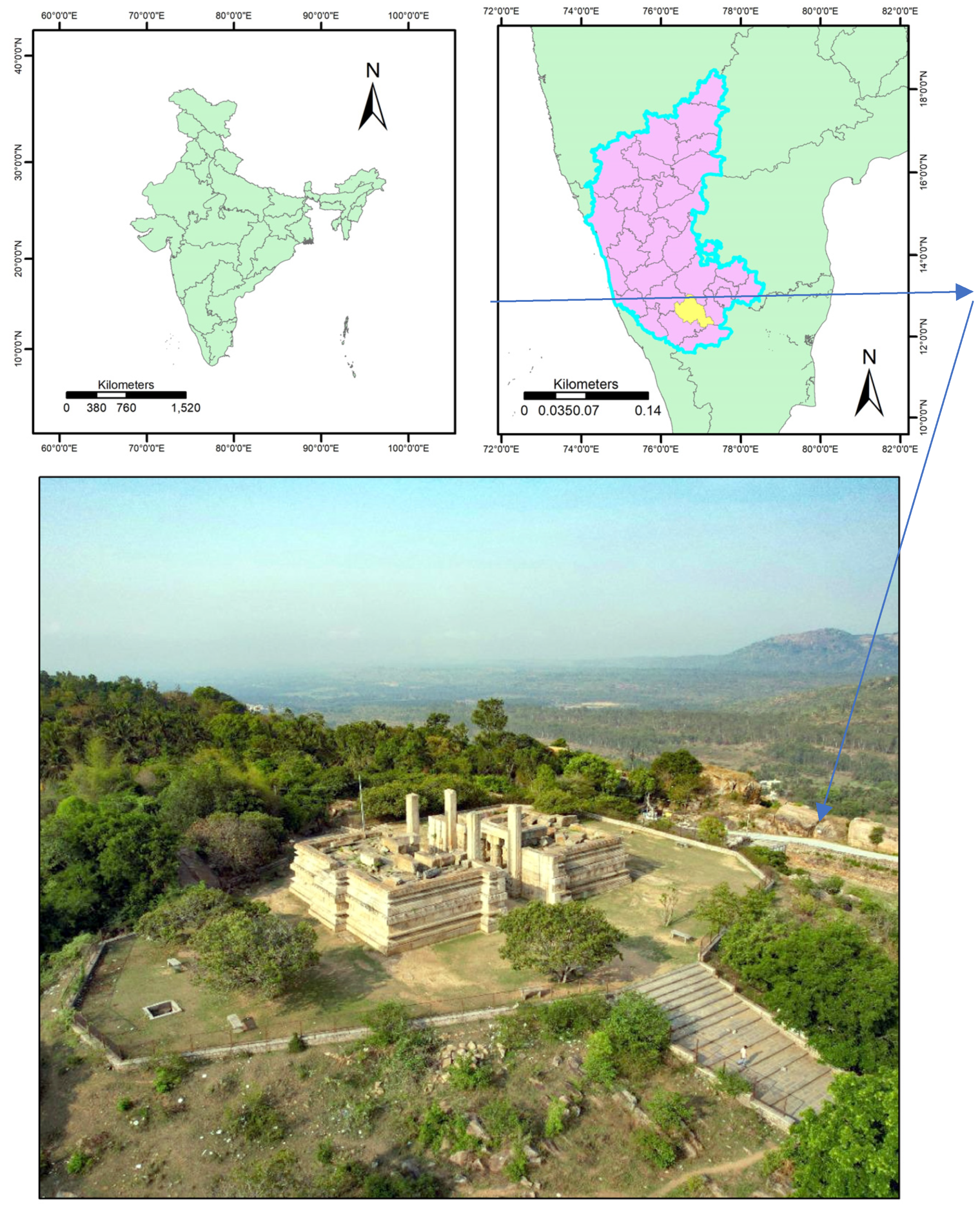
Figure 3.
Camera locations and image overlap (Blue regions have high overlap, and red regions have low overlap) of the survey.
Figure 3.
Camera locations and image overlap (Blue regions have high overlap, and red regions have low overlap) of the survey.
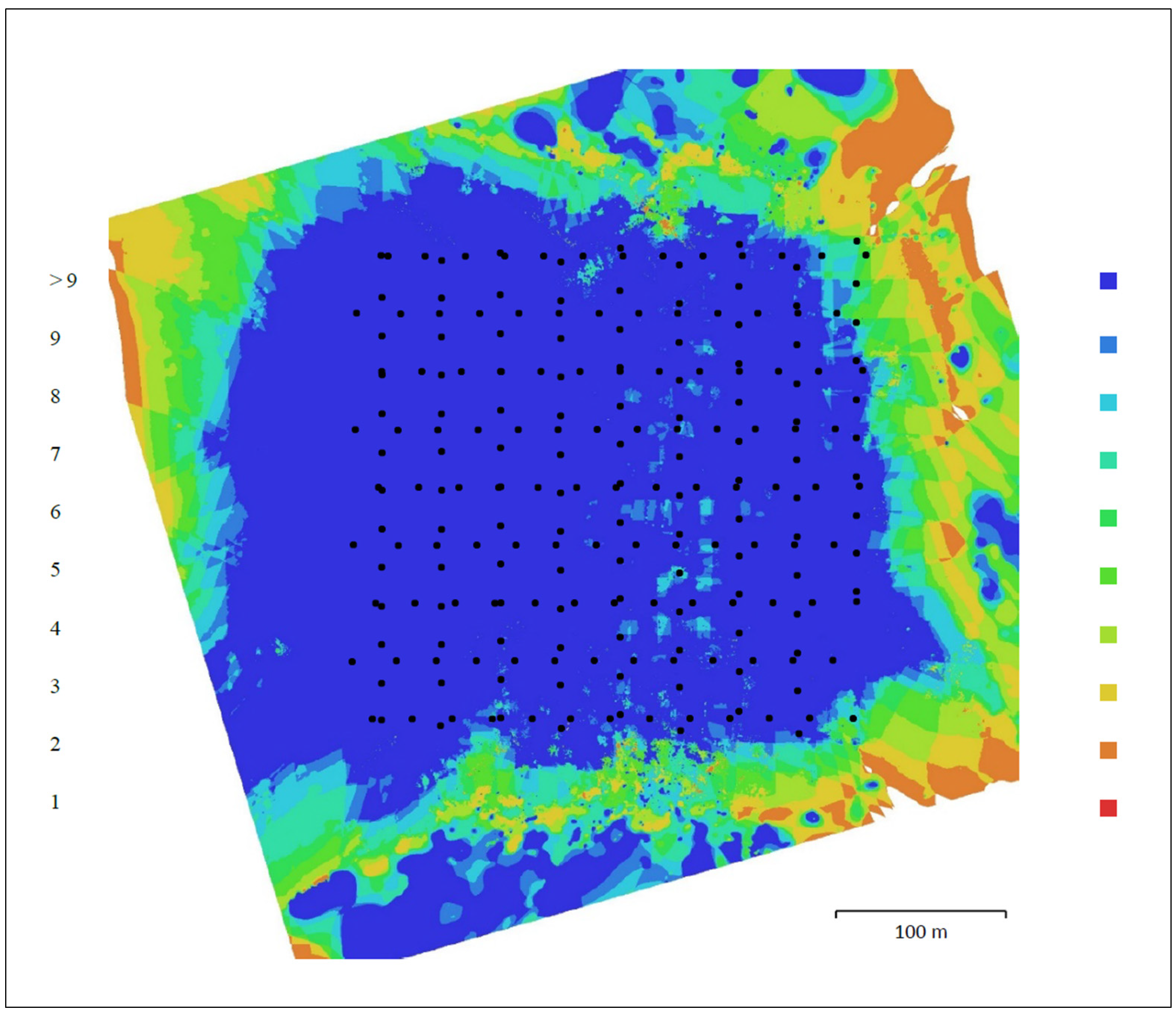
Figure 4.
Orthomosaic image output of the aerial survey (left) and zoomed orthoimage of the Raya Gopura (right).
Figure 4.
Orthomosaic image output of the aerial survey (left) and zoomed orthoimage of the Raya Gopura (right).
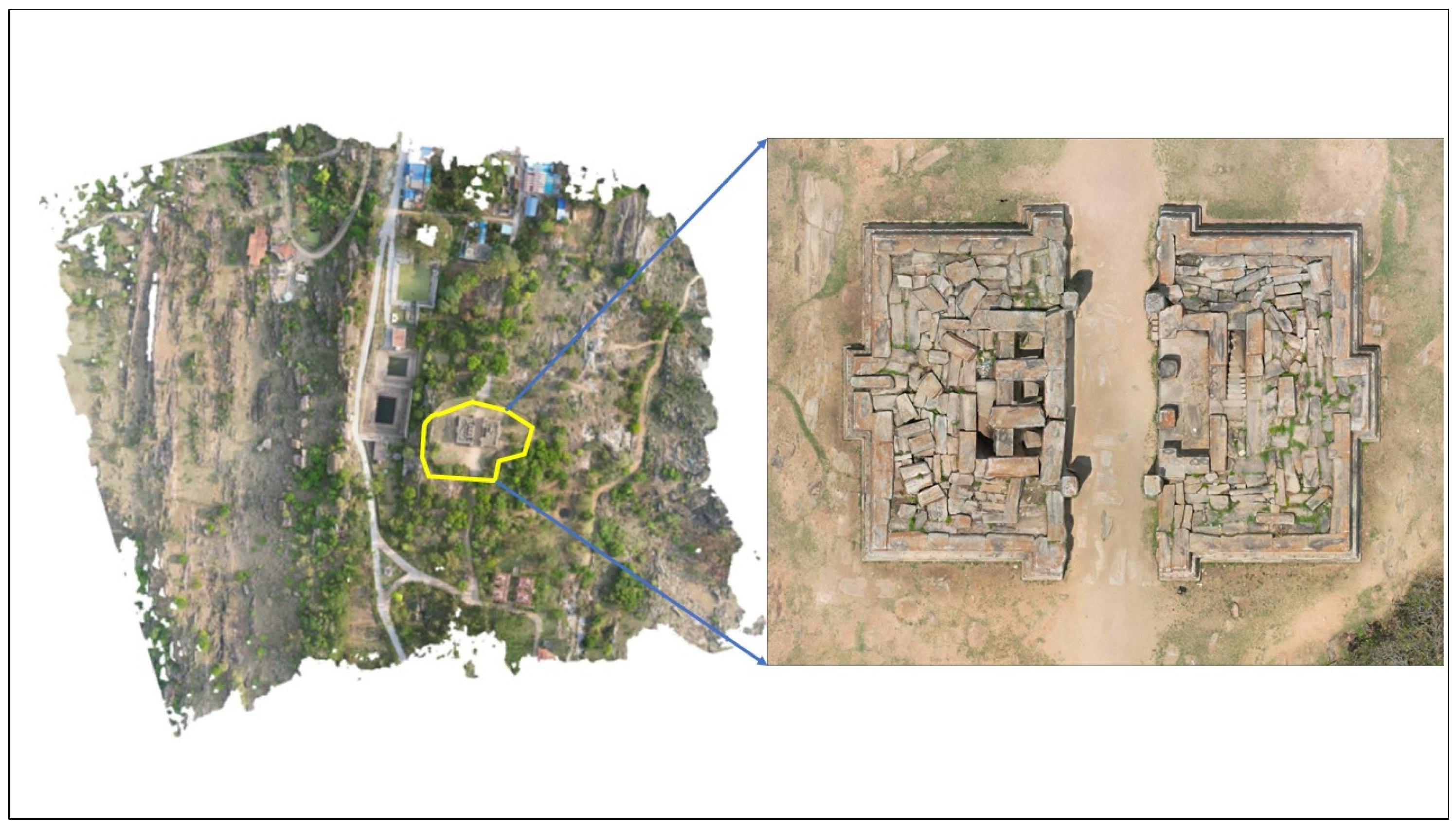
Figure 5.
Represents the high density registered TLS point cloud of the monument.
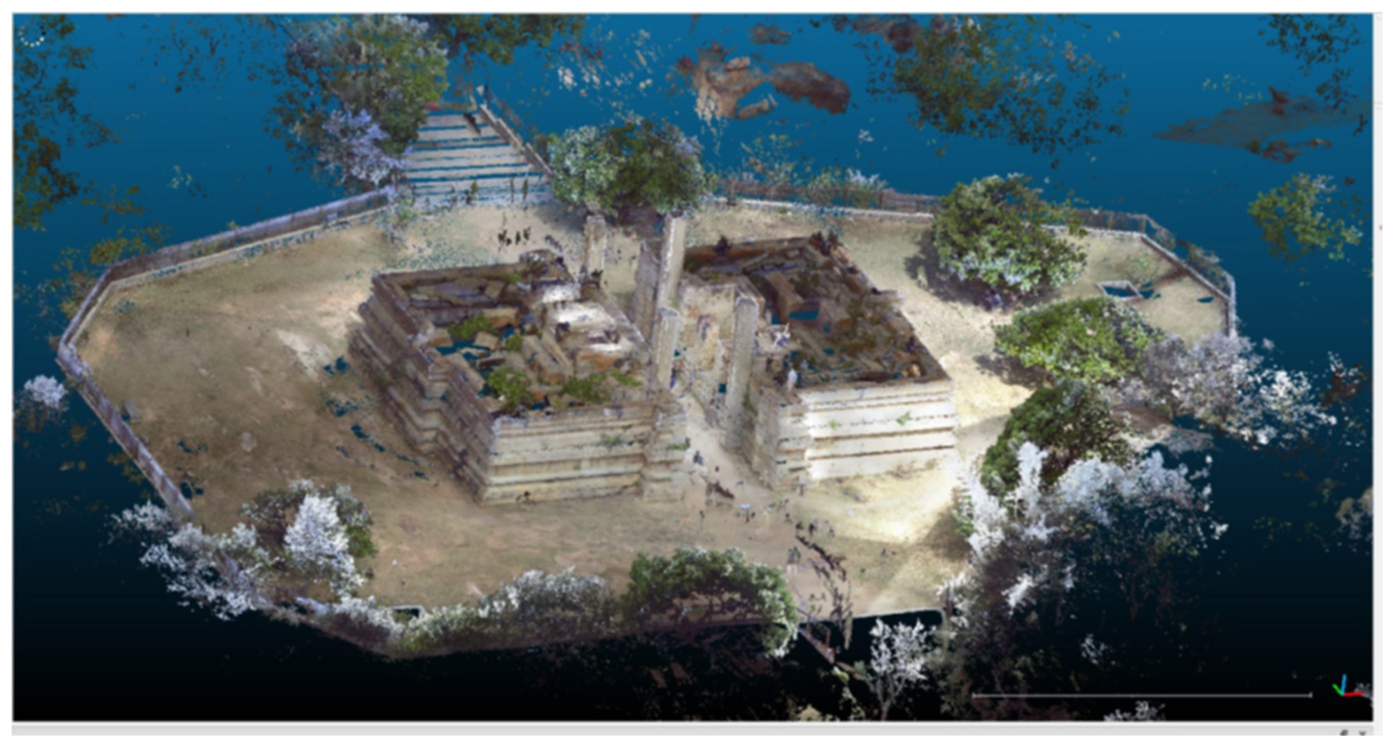
Figure 6.
(a) Depicts the camera positions of the Aerial and Terrestrial Camera after alignment; (b) Depicts the final realistic textured model of the monument.
Figure 6.
(a) Depicts the camera positions of the Aerial and Terrestrial Camera after alignment; (b) Depicts the final realistic textured model of the monument.
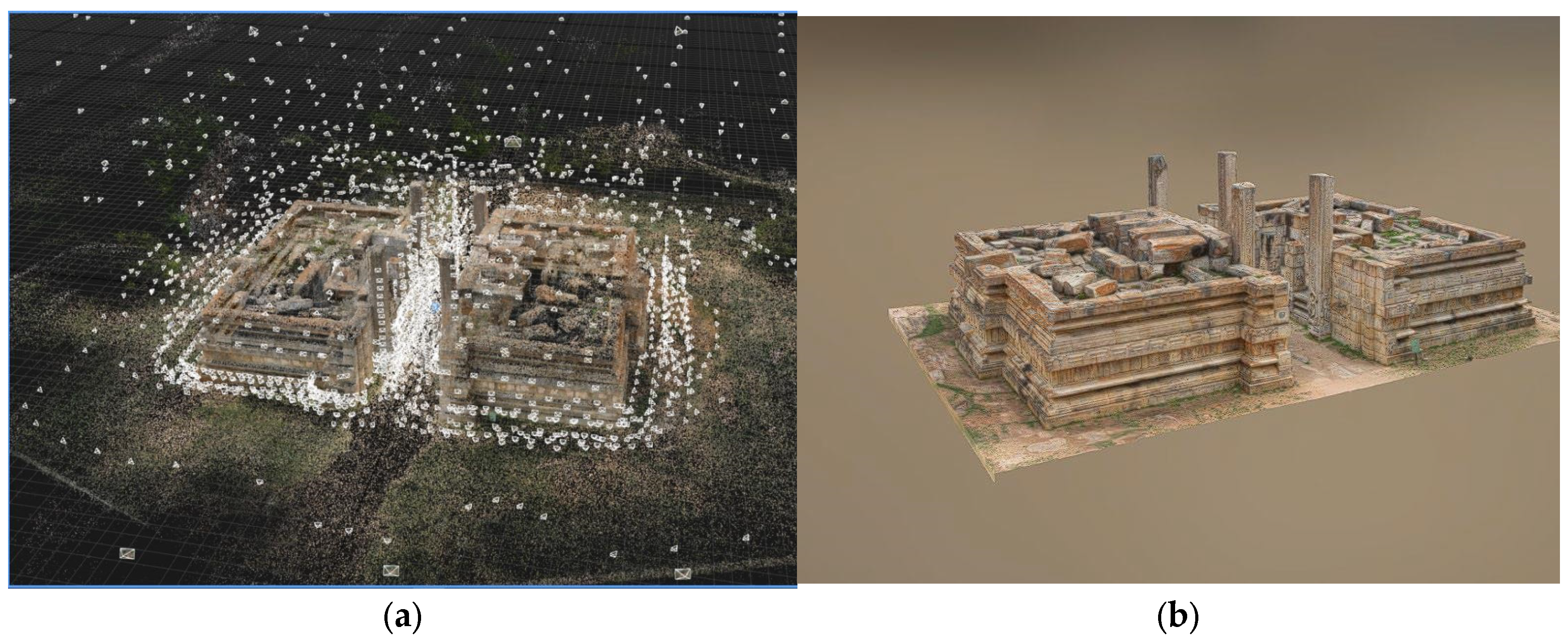
Figure 7.
Ground Plan of the Raya Gopura monument using CAD drawing.
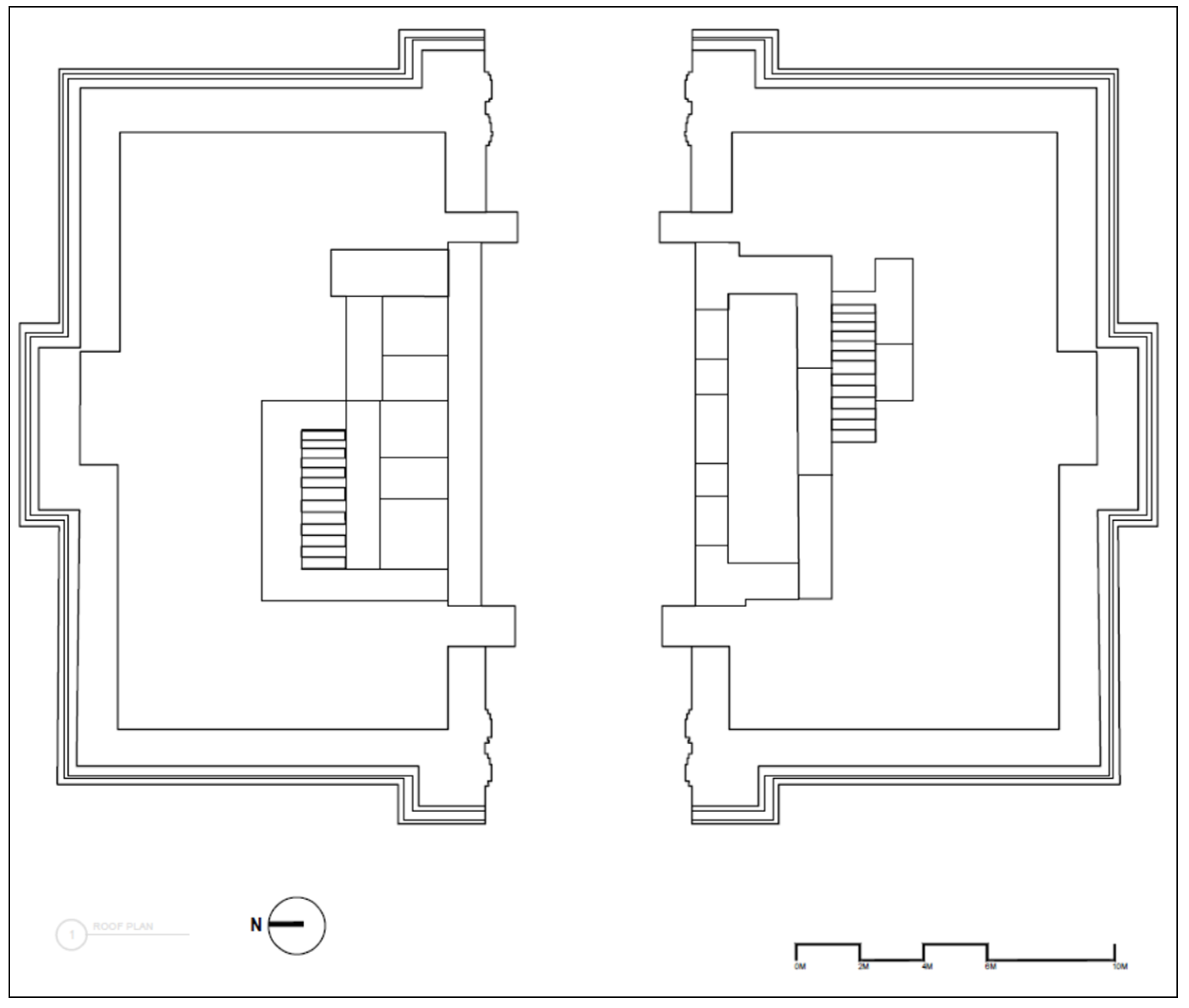
Figure 8.
(a) CAD drawing of the front elevation; (b) CAD drawing of the side elevation.
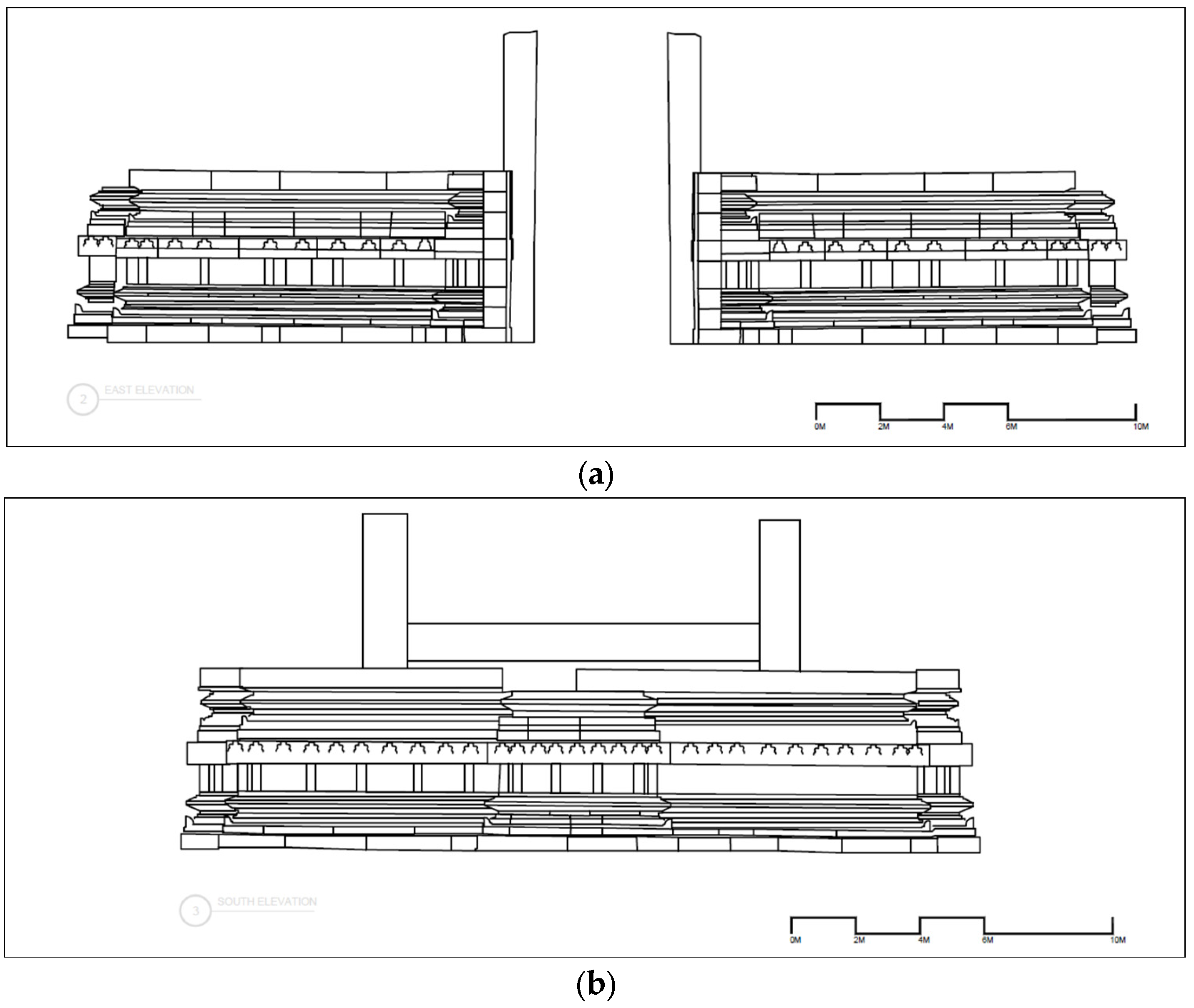
Figure 9.
Depicts the position of the (A) Sri Cheluvanarayana Swamy Temple and (B) Raya Gopura location on Google Earth image.
Figure 9.
Depicts the position of the (A) Sri Cheluvanarayana Swamy Temple and (B) Raya Gopura location on Google Earth image.
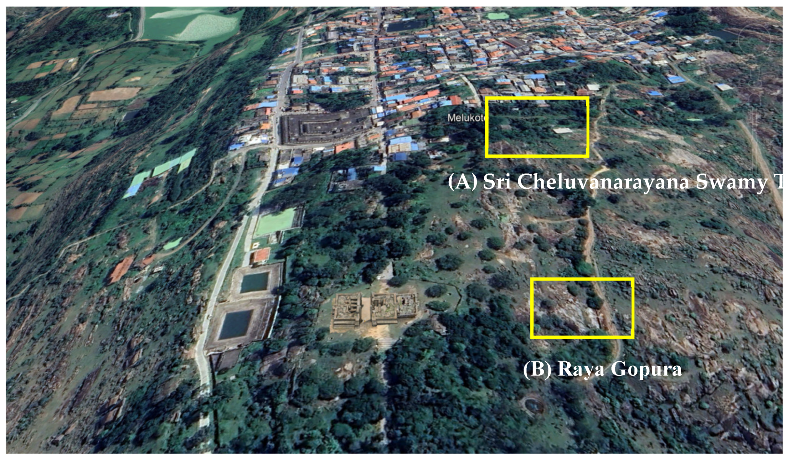
Figure 10.
Conjectural Drawing of the Raya Gopura—An Unfinished Structure.
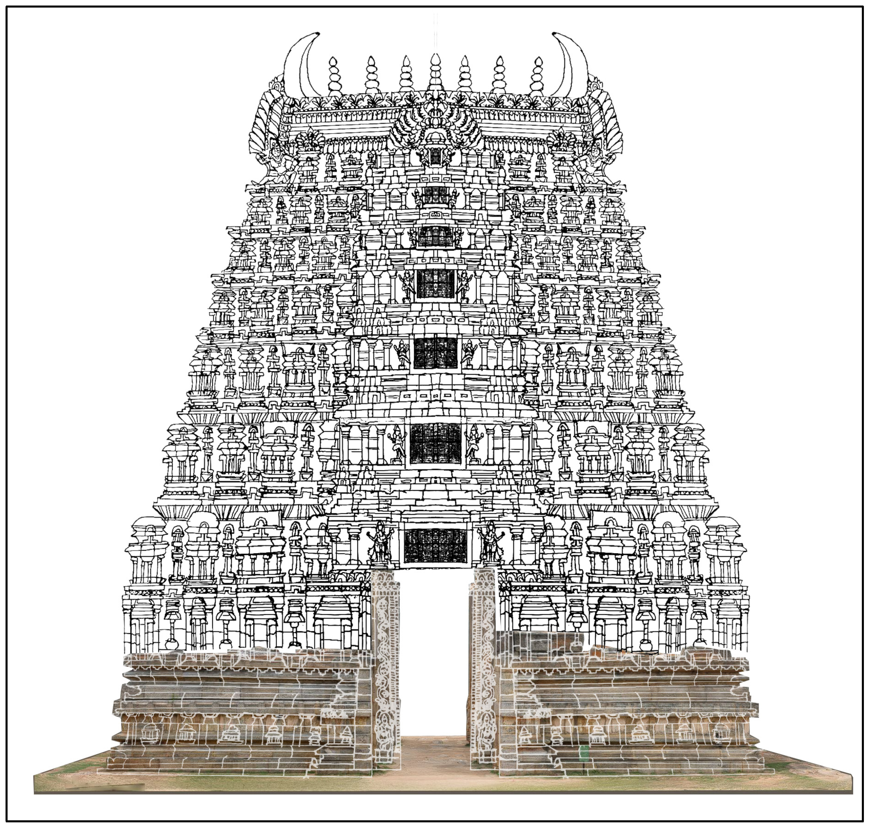

Table 1.
This table provides details of aerial survey conducted for the Raya Gopura and adjoining region.
Table 1.
This table provides details of aerial survey conducted for the Raya Gopura and adjoining region.
| Survey Details | |||
|---|---|---|---|
| Number of images | 231 | Camera stations | 231 |
| Flying altitude | 73.9 meters | Tie points | 246,531 |
| Ground resolution | 1.97 cm/pixel | Projections | 762707 |
| Coverage area | 0.227 km² | Reprojection error | 1.39 pix |
Disclaimer/Publisher’s Note: The statements, opinions and data contained in all publications are solely those of the individual author(s) and contributor(s) and not of MDPI and/or the editor(s). MDPI and/or the editor(s) disclaim responsibility for any injury to people or property resulting from any ideas, methods, instructions or products referred to in the content. |
© 2024 by the authors. Licensee MDPI, Basel, Switzerland. This article is an open access article distributed under the terms and conditions of the Creative Commons Attribution (CC BY) license (http://creativecommons.org/licenses/by/4.0/).
Copyright: This open access article is published under a Creative Commons CC BY 4.0 license, which permit the free download, distribution, and reuse, provided that the author and preprint are cited in any reuse.


