
Submitted:
13 January 2025
Posted:
13 January 2025
You are already at the latest version
Abstract
This paper presents a comprehensive scoping review of the application of 3D digital technologies in the documentation, conservation, and management of historic gardens and related cultural heritage. By analyzing a curated selection of literature, the study assesses the current state of research, highlighting trends in publication, geographic distribution of contributors, and the key technologies employed. Using bibliometric methods and visualization tools, followed by case study review, the review identifies significant research hotspots, technical methodologies, particularly focusing on advanced techniques such as mobile laser scanning, UAV photogrammetry, point cloud processing, and their relationships with end users. The findings emphasize the importance of integrating multiple technologies to capture the diverse elements of historic gardens, including architectural features, vegetation, and topography. The review also underscores the significance of dynamic landscapes facing challenges posed by environmental degradation and urban development pressures. Moreover, it discusses the limitations of existing research and outlines future opportunities, such as the development of 4D documentation systems and the incorporation of AI for improving heritage management. The paper concludes by recommending interdisciplinary collaboration and public engagement to enhance the accessibility, understanding, and sustainable management of historic gardens through innovative technological applications.
Keywords:
Historic gardens
; 3D digital technologies
; Cultural landscapes
; Cultural Heritage
; Geomatics
; Point cloud
1. Introduction
3D digital technologies enable the creation of highly detailed and accurate digital 3D models with computer-based tools and processes [1], which can be used for a wide range of purposes, from research and conservation to education and public engagement in Cultural Heritage (CH) [2].
This paper conducts a scoping review of literature to explore the application of 3D digital technologies in historic gardens and related heritage objects and then presents the topic in detail through some case studies. It aims to address the growing acknowledgement of the geomatics field's contribution to this field. This study examines suitable and promising 3D digital technologies for application in historic gardens.
1.1. Historic Garden
Currently, historic gardens constitute a distinct and delicate subtype within the domain of CH. Primarily, the garden's structure is inherently fragile; its principal, albeit not exclusive, focal plant elements are susceptible to significant damage even from brief periods of neglect and exhibit a dynamic quality shaped by vegetation growth, climatic fluctuations, and management decisions. Some historical gardens, born as private villa gardens and later transformed into public gardens or parks, have undergone great transformations that, in most cases, fail to preserve their original values and are often now man-aged like a common green public area. Conversely, it is currently acknowledged that gardens, especially in urban areas serve as a significant element of the landscape and as a pivotal component in shaping the cultural identity of the local populace residing near the gardens [3].
Historic gardens are an essential part of Cultural Heritage, reflecting the artistic, architectural, and horticultural styles of different eras and cultures. The Florence Charter, adopted by the International Council on Monuments and Sites (ICOMOS) in 1982, defines a historic garden as "an architectural and horticultural composition of interest to the public from the historical or artistic point of view" [4]. These gardens are considered living monuments that encompass a wide range of green spaces, from small formal gardens to expansive landscape parks. They combine permanent features, such as layout, topography, structures, and decorative elements, with the dynamic and perishable nature of vegetation [4].
According to the “Italian Charter of Historic Gardens” drafted in 1981, the historic garden, like architecture, can be understood as a palimpsest, a text repeatedly written and rewritten, possessing its own material consistency, with sedimented and stratified signs that cannot be erased [4,5].
Surveying gardens is essential and crucial to supporting documentation, study, analysis, and historical field research. In particular, the survey is indispensable in documenting any remaining evidence of gardens that no longer exist.
As a type of cultural landscape listed in the UNESCO Operational Guidelines (2023) [6], a historic garden could be “an area, perceived by people, whose character is the result of the action and interaction of natural and/or human factors” [7].
Historic gardens face numerous challenges today, such as natural deterioration, inadequate maintenance, and pressure from urban development [8]. Natural and human-induced disasters present substantial threats to these delicate landscapes, highlighting the need for comprehensive disaster risk management and consistent maintenance efforts. To ensure their preservation for future generations, detailed management plans that incorporate maintenance, conservation, restoration, and, in certain instances, reconstruction are crucial [4,9].
These plans should be grounded in thorough research and documentation, utilizing modern technologies and fostering collaboration among experts from multiple disciplines [4,10]. Furthermore, raising public awareness and promoting the value of historic gardens through education, research, and enhanced accessibility are essential for their long-term conservation [4,11].
1.2. 3D Digital Technologies
The application of 3D digital technologies has become increasingly prevalent in the field of CH, offering numerous benefits and opportunities ranging from documentary research for preservation to digital application for public engagement. These cutting-edge tools enable the creation of detailed, accurate, and immersive digital representations of cultural assets, such as artifacts, monuments, and sites, by capturing, modeling and visualizing them in a digital format. The process of creating digital representations involves several steps, including data acquisition [12,13,14], data processing [15], modeling [16,17,18], texturing [18,19], and visualization [20,21,22]. Various techniques and software tools are employed in each stage to ensure the accuracy, quality, and authenticity of the digital representation (Figure 1).
3D models as the main digital representations of objects or structures could be created from point clouds acquired using surveying techniques such as laser scanning, photogrammetry, or computer-aided design (CAD) software. These models accurately capture the geometry, texture, and appearance of the original objects, enabling detailed visualization, analysis, and other applications for end-users [23]. By creating accurate and detailed 3D digital models, the long-term preservation and management of cultural heritage assets can reap benefits, even in the face of potential loss or damage to physical objects and sites [24]. These digital copies provide comprehensive documentation, enabling researchers to conduct in-depth analysis and make informed decisions [25].
Moreover, 3D digital technologies enhance accessibility, allowing Cultural Heritage to be shared and experienced by people worldwide through online platforms and virtual environments [26,27,28]. They facilitate collaboration among professionals, foster interdisciplinary studies, and create new opportunities for education, creative industries, and sustainable heritage management. Ultimately, by harnessing the power of 3D digital technologies, cultural treasures can be safeguarded, new knowledge can be unlocked, and a deeper appreciation can be inspired for the shared heritage among future generations [29].
1.3. Current Application for 3D Digital Technology in Historic Gardens
ICOMOS has actively advocated for the purposeful and organized use of digital technologies, including 3D surveying, modeling, and information management, in Cultural Heritage projects [30].
In the field of historic gardens, 3D digital technologies have been making increasingly significant contributions and can become a beneficial tool to support heritage conservation efforts. For instance, Unmanned Aerial Vehicle (UAV) photogrammetry, Airborne Laser Scanning (ALS), Mobile Laser Scanning (MLS), Terrestrial Laser Scanning (TLS) or other 3D surveying techniques have been applied to historic gardens to acquire point cloud data and obtain satisfying and complete 3D geometric information [16,31,32].
By collaborating with other digital techniques including Geographic Information Systems (GIS), Information modeling, VR, AR or other Web-based technologies, 3D models of garden objects can be used for information management, interactive visualization, or stakeholder collaborations of garden heritage [33,34,35].
Historic gardens or parks are often extensive in scale, with abundant, diverse, and complex heritage elements. The application of 3D digital technologies to historic gardens, compared to other heritage assets like historical buildings and archaeological sites, can be more complicated and require different technologies and skills [36].
Digitizing historic gardens can mean a range from cartographic scale to high-detail objects. For instance, historic gardens possess a lot of different spatial features and patterns of dynamic change. Many technologies are needed to capture and record their topography, architectural structures, and vegetation, providing a reliable data foundation for subsequent stages (investigate, preserve, manage, etc.).
The optimal application of the digitizing process to historic gardens can actively contribute to their maintenance and conservation, provide valid metric support, and serve as a starting point for any other management tools (CAD, GIS, WEB, etc.).
1.4. Objectives
This article seeks to explore and illuminate the current state of advanced 3D digital technologies in historic gardens and related heritage objects. It thoughtfully examines the diverse techniques and tools employed in this realm and aspires to uncover opportunities and areas for further exploration within this field of research.
1.5. Scope
A scoping review presents an overview of a broad topic from a potentially large and diverse body of literature, sharing a rigorous and transparent method for comprehensive identification and analysis [37].
The scope of this review was defined based on the three conceptual constructs to explore the application of 3D digital technologies in historic gardens and related cultural heritage. A comprehensive list of key terms for the literature search was developed (Table 1).
To comprehensively obtain literature related to this topic, the concept of “historic garden” was divided into two conceptual constructs. In the “Adjectives for Heritage Con-struct”, similar adjectives such as “Historic”, “Historical”, “Heritage”, and “Archaeological” were used to present the historical values of objects. According to the definition and scope of the historic garden [4], in the “Garden Construct”, in addition to the common key term “Garden”, “Park” was included to represent gardens and related objects. Regarding 3D digital technologies, this article focuses on the 3D data acquisition, processing, modeling and visualization of heritage objects, and point cloud as a fundamental component. Therefore, “Point Cloud”, “3D Survey”, “3D Modeling” and “3D Visualization” were selected as key terms in this conceptual construct to explore the applications of 3D digital technologies.
1.6. Structure of Scoping Review
This article critically selects and reviews current international research papers on the application of 3D digital technologies in historic gardens and related fields. The structure of scoping review covers five parts [37]:
- Identifying research question(s);
- Searching for literature;
- Selecting studies;
- Extracting and mapping data;
- Synthesizing and reporting the results.
Based on the research objectives, three review questions of this article are posed:
- What is the current state in this research field?
- How are 3D digital technologies applied to historic gardens and related heritage objects?
- What could be the current gaps, and which 3D digital techniques and tools could be more suitable or promising for this research field?
To answer these questions, this paper continues the review by identifying relevant articles using key search terms and predefined inclusion/exclusion criteria. The selected articles are then subjected to data extraction and analysis. Based on the synthesized results, the paper discusses current gaps in literature and proposes potential directions for future research within this field of study.
2. Materials and Methods
This scoping review follows the PRISMA-ScR guidelines [38]. This section details the eligibility criteria, information sources, search strategy, and the process for selecting evidence sources based on inclusion and exclusion criteria. It also includes the key search terms used, the data charting process, the specific data items collected, and the methods for critically analyzing and synthesizing the results.
2.1. Eligibility Criteria
The final review papers were selected based on the following inclusion and exclusion criteria:
- Articles published in English or in other languages with available English translations were included.
- Books or conference proceedings were excluded.
- Articles not related to heritage, gardens and 3D digital technologies were excluded.
- Only articles with full text access were included.
2.2. Search Process
To identify relevant studies for the research topic, two comprehensive database searches were conducted based on key search terms, and the literature search process concluded with the final queries executed during January 2025:
- In Scopus, the search query employed a combination of keywords which were found in the article’s title, abstract or author keywords, specifically: TITLE-ABS-KEY ((“Historic” OR “Historical” OR “Heritage” OR “Archaeological”) AND (“Garden” OR “Park”) AND (“Point cloud” OR “3D Survey” OR “3D Modeling” OR “3D Visualization”)). This initial search yielded a total of 158 records.
- In Web of Science, records where the search terms appeared in any part of the database record were retrieved. In detail: ALL = ((“Historic” OR “Historical” OR “Heritage” OR “Archaeological”) AND (“Garden” OR “Park”) AND (“Point cloud” OR “3D Survey” OR “3D Modeling” OR “3D Visualization”)). The preliminary search query resulted in the retrieval of 103 records.
Finally, a total of 261 studies were identified (Table 2).
2.3. Screening
The screening process involved systematically evaluating the eligibility of each article by reading the titles, keywords and abstracts of all records and applying the inclusion/exclusion criteria initially. If an article was deemed to meet the criteria, the full text would be accessed online and selected if available. The full text of the records was reevaluated against the eligibility criteria to obtain final review articles. Figure 2 illustrates the screening process, and the inclusion stage resulted in the selection of 58 studies from 2001 to 2024 for the literature review.
2.4. Data Charting
Data from the included articles were extracted and entered into a custom-designed data sheet addressing the three review questions and review objectives. The extracted data categories included:
- Reference: Author(s)/Date of publication;
- Source: Publishers/Journals or organizations contributing to academic work;
- Country (For studies with authors from different countries, the affiliations were grouped under “International cooperation” or “European cooperation”);
- Types of heritage studied;
- Location of heritage;
- 3D digital techniques and tools applied;
- Objectives and results.
For Reference, Source and Country data, information was gathered after retrieving the relevant articles. Other data were extracted from the abstracts or full texts. These data were subsequently analyzed and synthesized to address the research questions and objectives.
2.5. Analysis and Synthesis
Two primary methods were employed for the analysis and synthesis of extracted data and papers included. Firstly, bibliometric methods and statistical functions were applied to analyze the Reference, Source, and Country data, with the aim of evaluating the impact, performance, and characteristics of research outputs within this specific field of study [39]. This analysis provided insights into influential publications, key authors, and the geographical distribution of research activities.
Subsequently, the data extracted from abstracts or full texts were organized into keyword groupings and analyzed using the same bibliometric approach. This categorization facilitated the identification of prevalent technical methods and tools, as well as the research focus concerning various heritage objects and their respective locations. Through synthesis, the relationships and interconnectedness among the papers were explored, revealing potential patterns and trends within the discipline.
Finally, building upon these analyses, a case study review method was employed to conduct an in-depth examination of selected cases from the reviewed papers, thereby enhancing the understanding of the practice of 3D digital technologies in historic gardens and related elements.
3. Results
This section presents a comprehensive analysis and synthesis of the findings from the included studies. The first part employs bibliometric techniques and data visualization to provide an overview of literature. The second part offers a detailed examination of the methods employed in the selected studies and their implications through case study review. These findings contribute to a deeper understanding of the current state of knowledge in this specific research field and are further discussed in the following section.
3.1. Overview of the Included Studies
3.1.1. Interannual Distribution of Paper
Since 2001, the application of 3D digital technologies has become increasingly prominent in this research field as evidenced by the growing volume of publications on this topic (Figure 3).
It is noteworthy that, after 2016, there has been a consistent upward trend in the number of publications, culminating in a peak in 2023. This trend indicates a growing interest and heightened research activity in the area.
The rise in publications may suggest potential breakthroughs or significant advancements in the application of 3D digital technologies to historic gardens and related cultural heritage contexts during this period. Contributing factors to this increase may include technological advancements, improved accessibility to tools and software, and a rise in research funding and collaborative efforts. While there have been intermittent declines in the number of published papers since 2017, this may reflect the substantial time investment required for research projects focusing on this subject, particularly in areas such as data collection, analysis, and interpretation, which can significantly extend the research lifecycle.
3.1.2. Distribution of the Affiliations of Researcher by Country
Italy emerges as the leading country, with its researchers and institutions contributing the highest number of publications in this research area (Figure 4). This highlights that Italy has a robust and active research community dedicated to exploring the applications of 3D digital technologies in historic gardens and associated fields [40].The country's rich Cultural Heritage, numerous historical sites, and strong emphasis on preservation and conservation may have contributed to this significant research output. China follows Italy as the country with the second-highest number of publications, indicating a substantial research interest and expertise in this domain. The presence of several historic gardens and a vibrant research community in China may have fueled this notable contribution to the field. Except for national cooperation, international cooperation and European cooperation indicate that collaborative initiatives and research inputs from diverse global regions are influencing the application of 3D digital technologies in historic gardens.
3.1.3. Distribution of Author
Approximately 200 researchers contributed to the selected literature. To analyze co-authorship patterns, authors with more than two publications in this review were selected to explore their relationships with other researchers in the field. Ultimately, six authors were identified, forming four co-authorship clusters (Figure 5). Each cluster represents a distinct research community: two are based at the Polytechnic University of Milan and the Polytechnic University of Turin in Italy, while the other two are from Nanjing Forestry University and Tongji University in China. These institutions have made significant contributions to the application of 3D digital technologies in historic gardens.
However, most of the research activities represented in these publications are based on national cooperation. This is evident in the collaboration among researchers within universities and between universities and related research institutions, organizations, or companies. There are still significant opportunities for international technical cooperation and exchange in this research domain.
3.1.4. Distribution of Source
The selected papers are distributed across 34 journals and other academic contributions. The top ten journals, conferences, and proceedings account for a significant proportion of the published papers, with high influence, as shown in Table 3.
The papers published in these journals or other sources collectively cover the multi-disciplinary and multi-scale characteristics of digital technologies in the preservation and study of historic gardens and related areas. They reflect a convergence of fields including Digital Humanities, Cultural Heritage, Remote Sensing, Geomatics, Urban Development and Computer Science, demonstrating the breadth and depth of ongoing research. These publications explore various aspects, including the use of multiple data sources, the integration of different technologies, key technological advancements, and innovative applications, which highlight the growing trend of technological collaboration and interdisciplinary integration in this domain.
3.1.5. Types of Cultural Heritage Studied
The types and location of heritage objects were extracted from the selected papers to demonstrate the diverse research focus on historic gardens and related heritage objects across different countries (Figure 6).
The research objects can be divided into two categories: studies that focus on historic gardens as an object, investigating the application of 3D digital technologies to historic gardens and parks; and studies that consider historic gardens as an area, examining the heritage objects contained within or associated with them, such as monuments and public buildings, forests, historical fountains, rockeries, towers, trees, and villas. The research emphasis on different types of historic garden heritage varies among countries, depending on the location and context of the heritage sites. For example, studies in Italy are probably the most inclusive, involving monuments and public buildings, trees, fountains, and villas, while those in China focus more on rockeries. This variation in research focus is influenced by the unique cultural, historical, and environmental factors that shape the characteristics of historic gardens in each country. Moreover, the choice and application of digital technologies in these studies are determined by the scale and features of the research objects. The diverse range of heritage objects within historic gardens, from individual elements like trees and fountains to larger structures such as towers and villas, requires tailored technological approaches.
3.1.6. 3D Digital Techniques for Data Acquisition in Historic Gardens and Related Fields
The application of 3D digital technologies for data acquisition in historic gardens and related heritage objects is driven by the pursuit of accuracy, non-invasiveness, non-destructiveness, efficiency, and cost-effectiveness. These key factors influence the choice of data acquisition techniques in this domain. Data acquisition is the primary and crucial step in applying 3D digital technologies, and as Figure 7 illustrates, various technologies have spread rapidly in the historic garden field. The acquisition technologies include photogrammetry and laser scanning, terrestrial and airborne methods, and static and dynamic mobile scanning, allowing for adaptation from a single object to a large area.
3.1.7. 3D Digital Technologies in Historic Gardens and Their Use by End Users
Following the extraction and analysis of keywords from the selected literature, this synthesis offers a comprehensive framework for understanding the complex interactions between various 3D digital techniques, heritage objects, and their end users within the context of historic gardens (Figure 8). Generally, the first purpose of the survey is to produce a complete and accurate description of the site geometry. With 3D survey data, it is clear that all the other 3D representations have been added together with the technical representations (plans, sections, profiles). The 3D data and models can then be used in various other applications.
By mapping the connections between acquisition methods and the specific elements they are applied to, such as villas, vegetation and trees, towers, rockeries, monuments and public buildings, these relationships emphasize the versatility and adaptability of these technologies in addressing the distinct challenges posed by the multifaceted nature of historic gardens.
Additionally, these acquisition methods operate within a broader system of digital technologies, including web-based visualization tools, virtual and augmented reality platforms, machine learning algorithms, Building Information Modeling (BIM), and GIS. This integration underscores the interdisciplinary nature of Cultural Heritage development and the potential for combining multiple technological solutions to enhance the documentation, analysis, interpretation, and dissemination of knowledge regarding historic gardens.
By examining the various end uses of the acquired 3D data, ranging from visualization and research to conservation planning and public engagement, the analysis demonstrates the pivotal role that 3D digital technologies play in facilitating sustainable management practices. These technologies enable innovative research approaches, support restoration efforts, and promote greater accessibility and appreciation of historic gardens among diverse audiences.
Furthermore, the framework recognizes the importance of addressing the needs and perspectives of various stakeholders, including experts and the public, in developing and applying these technologies. This focus on user-centered design and participatory methodologies reflects the growing recognition of the social and cultural dimensions of heritage preservation, as well as the necessity for inclusive and collaborative strategies in safeguarding Cultural Heritage.
3.2. Key Studies
Historic gardens, including gardens and parks, differ in their features, cultural significance, and developmental needs. These differences directly influence the choice of 3D digital technologies and how they are applied. The selected case studies explored a range of 3D representation goals, from capturing individual garden elements to documenting entire garden or park areas.
The case studies also examined the use of geomatics tools and procedures for surveying historic gardens. They discussed the strengths and limitations of these methods and highlighted how 3D digital data could be applied in practical ways. This included supporting conservation efforts and enhancing visitor experiences. The research demonstrates how 3D technologies can be adapted to address the unique requirements of different historic gardens, making them valuable tools for both preservation and sustainable use.
Geomatics techniques represent an effective tool for obtaining the requested technical drawings and 3D representation and making them available to researchers and conservators. In its most diverse forms, surveying is the first essential step and indispensable for studying gardens and organizing and planning their conservation and management activities.
The introduction of new technologies, tools, and methods is transforming site surveying processes and the outcomes of mapping activities. At the same time, it is also shaping how digital data is applied in the development and management of historic gardens.
3.2.1. Survey of Historic Gardens or Parks in the Past
In the past, the surveying process consisted of measuring single points on the field by total station or by GNSS and producing 2D drawings from these data using CAD software. Especially in the past, it was crucial to establish an accurate reference network, as described in [43], with well-materialized vertices of known coordinates, unambiguously identifiable and positioned in stable areas. These vertices were measured typically by using total station or, for large areas, by GNSS. This strategy required a lot of time in the field. The expected results consisted of tens or hundreds of measured points chosen by the operator, which were then used to produce 2D technical drawings or basic 3D models (Figure 9).
Afterward, topographic surveying techniques evolved rapidly and continuously, and today, the classic ones are flanked with the data generated by a laser scanner or image elaboration.
3.2.2. 3D Survey of Historic Gardens
The elements of a garden are diverse and intricate. Each feature, from plants to architectural structures, holds symbolic meanings connected to culture, philosophy, or religion. These meanings are also reflected in the spatial relationships between elements. For a long time, the preservation and development of gardens relied mainly on 2D mapping tools and techniques.
Now, advanced technologies provide more options for capturing 3D data. In gardens, especially classical ones, different 3D surveying methods are being explored to collect detailed information about individual objects. Researchers also combine various techniques to create full 3D models of entire gardens. These models are used with other tools, supporting conservation and management, offering a deeper understanding of the garden as a whole.
Terrestrial Laser Scanners can capture reality with a massive number of points and resolutions selected according to the project's final target. The process of capturing 3D reality has become more efficient and fast compared to the labor-intensive task of conducting a comprehensive survey using a total station. However, the post-processing efforts of managing the vast quantity of data obtained by the TLS have significantly increased compared to the restitution activity required by a classical survey.
Currently, TLS is widely used in heritage conservation due to its ability to capture detailed 3D models of complex structures. This makes it especially suitable for historic gardens with diverse elements and intricate layouts, even when they cover relatively small areas. For example, Jia and colleagues used TLS to collect detailed 3D spatial data of the Jianxin Courtyard, a representative site of Chinese royal gardens, covering an area of 5,257 m². The survey included 102 sites with point cloud data (Figure 10) [44].
Using the point cloud data of the entire Jianxin Courtyard, the study classified and extracted garden elements, including the water body, vegetation, rockery, architecture, and surrounding environment. These data were then used to build information models, which ultimately supported the conservation and management of these elements.
Compared with TLS, UAVs enable rapid data collection over large areas, accessing challenging terrains that TLS may not reach. UAV photogrammetry is generally more cost-effective and provides high-resolution imagery, facilitating the creation of detailed 3D models and orthophotos. While TLS excels in precise geometric measurements of manufactures, the flexibility and efficiency of UAV photogrammetry make it a valuable complement, particularly for documenting complex landscapes and structures in vast Cultural Heritage contexts that require an approach at a cartographic scale.
In another case study, Liang et al. [45] used a combination of TLS, Terrestrial Digital Photogrammetry (TDP), and Unmanned Aerial Vehicle Digital Photogrammetry (UAVDP) to document Huanxiu Shanzhuang (HXSZ), a Chinese classical garden and UNESCO World Heritage site. The garden covers an area of 2,179 m² and features rich spatial layers and diverse landscape elements. This approach created accurate 3D models and 2D drawings of the garden’s intricate spatial elements (Figure 11).
Different surveying techniques were combined to map various garden elements. For large-scale features or areas, such as garden buildings, vegetation, and water bodies, UAVDP and TLS were used together to capture point cloud data. For smaller, more structurally complex objects like rockeries, TLS and TDP were combined to ensure detailed information.
Unlike the Jianxin Courtyard case, the HXSZ project includes an integration process involving both coarse and fine registration of point clouds from TLS and UAVDP. This is followed by the incorporation of TDP data. This multi-step process ensures the final models are highly precise and complete, capturing the garden’s complex spatial relationships and diverse elements.
From Chinese gardens to Italian garden, the survey of the Giardino delle Camelie (304 m²), a small but significant portion of the Boboli Gardens in Florence, combined photogrammetry and TLS to document the garden's geometric and material characteristics (Figure 12) [46]. Challenges like dense vegetation, poor lighting, and narrow spaces were addressed through careful planning. This included setting up a strong topographic network and using integrated data acquisition methods. Laser scans provided high-resolution spatial data, while photogrammetry captured detailed surface textures, resulting in a comprehensive 3D model. This model allowed for the creation of accurate orthophotos and CAD drawings, which were essential for planning restoration work.
In this case, the authors discussed the challenges of acquiring 3D data for historic gardens, particularly the difficulties in accessing certain areas and obtaining data for vegetation. The combination of different survey campaigns provides elements to know and describe the characteristics of the garden, both in its surface (botanical, architectural, and decorative) and spatial composition.
3.2.3. 3D Survey of Natural Elements
In the surveying of historic gardens, artificial elements such as buildings and rockeries in Chinese gardens, or villas and fountains in European gardens, have benefited from 3D digital technologies. These technologies, inspired by their use in historic buildings and sites, have been adapted for garden surveying. However, the documentation of natural elements is still being explored, and new techniques are being developed. Several case studies illustrate this ongoing process.
Mobile Mapping Systems (MMS) are advanced surveying tools that combine multiple sensors, such as LiDAR and high-resolution cameras, to collect spatial data while moving through an environment. In historic garden surveying, MMS is being increasingly applied. It allows for fast and efficient data collection over large or complex areas, producing detailed 3D point clouds that accurately represent terrain features, vegetation, and architectural elements. This approach significantly reduces survey time and improves data accuracy compared to traditional static scanning methods.
Among the most essential elements in gardens are trees. As living heritage and key parts of the garden ecosystem, trees need to be documented using various techniques. These methods support their inventory, preservation, and management.
A case study was conducted in the Villa Burba historical garden, Italy [12], with an area about 16000 m2. The authors evaluated the Heron Backpack Mobile Mapping System (MMS) [47] and the Ant3D multi-camera photogrammetric system [48] to analyze their effectiveness in creating detailed point clouds for garden characterization, particularly focusing on tree inventory metrics like Diameter at Breast Height (DBH) and canopy foot-print. The Heron Backpack proves to be a practical choice for fast, complete surveys of large areas, especially for tree characterization (Figure 13 and Figure 14). Its ability to cover both trunks and canopies efficiently make it highly effective, though the noise in its data limits its use for highly detailed analysis. The Ant3D system excels in creating detailed, noise-free models of architectural and ground-level features, making it suitable for projects where precision and detail are prioritized over speed.
In Villa Burba, a combination of IMMS and UAVDP point clouds was used to extract a DTM of the entire garden, which was represented by contour lines, and a 2D CAD drawing was produced. The measurements and drawings included the canopies of the trees, denoted by green circles, the trunk sections of the trees at a standard height of 1.30 meters from the ground (Figure 15), and the internal and external plans of all the structures, including the Manor House and other buildings situated on the property.
Another case study [36] was conducted in a 2400 m² wooded area in Monsanto Forest Park, Lisbon, Portugal. This area, with its mix of natural and recreational features, including uneven terrain, dense tree cover, and elements like wooden furniture and bins, provided a good environment to test the capabilities of MLS and TLS for garden documentation (Figure 16).
This case highlighted the trade-offs between precision and efficiency in garden surveys (Figure 17). The TLS system is ideal for detailed surveys that require high-quality, low-noise point clouds, especially for tasks like measuring tree diameter at breast height (DBH) or capturing detailed trunk boundaries. However, TLS is time-consuming and requires extensive setup. In contrast, the MLS system, while producing noisier data, excels in speed and flexibility. It is better suited for large-scale surveys or projects with time constraints. The MLS system's SLAM technology enables seamless data collection, even in challenging environments like dense forests or uneven terrain.
In the future, improvements in noise reduction for MLS data or enhancements to SLAM algorithms could make MLS a more competitive option for surveying the natural parts of gardens.
3.2.4. 3D Survey of Historic Parks
Unlike existing classical or private historic gardens, some gardens that were once private have now become public spaces or historical parks. These gardens typically feature large-scale areas with complex and varied terrain and elements. This means that a single 3D surveying technique cannot meet all their needs. From individual objects to the broader geographic context, it is necessary to choose and integrate the right 3D technologies.
For larger heritage areas, aerial LiDAR has become an essential tool, capturing high-resolution 3D data for detailed mapping of complex landscapes, including topographical variations, vegetation distribution, and architectural features.
A case study of the Wormsloe State Historic Site, a 400-ha historical park in Savannah, Georgia, USA, was documented using multiple 3D technologies. These included aerial LiDAR, TLS, and Structure from Motion (SfM) techniques applied to images captured by UAVs and handheld cameras. This study explored point cloud mapping methods [49]. It highlighted the importance of precise 3D point clouds for assessing cultural landscapes, which included both physical structures and the ecological context of the site. Additionally, after comparing different techniques, the findings suggested that even lower-cost solutions, such as UAV and handheld photogrammetry, could produce point clouds that were comparable in quality to those generated by more expensive laser scanning.
In addition, unlike the conservation and management of typical historic gardens, the creation of 3D model documentation alone cannot meet the needs of historical parks as open spaces in modern society. The different land uses within historical parks are also influenced by local urban planning. This means that, unlike gardens, the collection of 3D data is not only for preserving and managing the cultural and historical values but also needs to be utilized for planning and developing the park. The 3D surveying technologies here must be integrated with other digital tools, making the data usable by people from various fields.
A case study from an archaeological garden in Naxos, Sicily, illustrates this well. This historic park spans about 250,000 m², and the survey used MLS and UAV photogrammetry for the entire park area, with higher resolution terrestrial laser scanning for the archaeological areas and buildings [50]. A topographic network was established across the entire park, with targets measured by both scanners and UAVs.
The survey was the first step in an extensive project, to remove architectural and cognitive barriers for visitors to the archaeological site and museum [51]. The project involves experts from geomatics, restoration, diagnostics, and architectural design. Unlike typical 3D information systems built for the conservation and management of historic gardens, the survey data in this case needed to be interpreted and made available to different users, assisting in park activities planning and the development of internal facilities.
3.2.5. Other 3D Digital Technologies for Historic Gardens
In the application of 3D digital technologies in historic gardens, the majority of case studies have still focused on the technical breakthroughs in data collection within the field of geomatics. However, it is worth noting that only a few cases have explored the impact of digital technologies on 3D modeling and visualization of point cloud data in historic gardens.
For instance, after acquiring point cloud data from Japanese gardens using laser scanning technology, Kumazaki and Kunii [18] extracted point clouds of trees. Based on this, they generated mesh models and created detailed 3D tree models using 3D modeling techniques. These models included detailed information about the leaves, branches, and trunks, as well as their physical shape and color (Figure 19). This work contributes to the development of a database for different types of elements in Japanese gardens. Trees, being an important feature of many gardens, are no longer merely obstacles to significant artificial elements. 3D point clouds help create detailed and accurate 3D models, which are essential for the conservation and management of gardens.
In addition to the essential elements that compose a garden, spatial relationships and visual characteristics are also key features. These aspects are clearly reflected in the overall 3D point cloud data through visualization. To better support professionals in the protection and management of gardens, one case study used point cloud data to highlight the spatial and visual relationships within the garden. Jichang Garden, a historic garden in Wuxi, China, renowned for its visual design and spatial layout, was chosen for this study [31]. The researchers employed a GIS-based method to analyze the visual landscape, con-verting point cloud data into voxels and utilizing GIS tools to reveal the garden's spatial and visual features (Figure 20). This approach offers a practical, efficient, and time-saving way to analyze and understand the visual landscape of historic gardens.
In contrast to the previous case studies, where the 3D datasets primarily served professionals, this research demonstrates the application of 3D digital technologies for both public engagement and scholarly use. Leveraging point cloud data captured through laser scanning, a dynamic 3D model of the Tropical Botanical Garden in Lisbon, Portugal, was developed using GIS tools [53]. A spatial database was created to organize data from diverse sources, including 3D models of plants, buildings, and sculptures, complemented by webpages (JBT 3D) containing historical and contextual information. Furthermore, interactive 3D scenes were made available, integrating VR functionality (Figure 21). This case exemplifies the synergy of multiple 3D digital technologies, providing the public with access to the garden's historical and botanical data, while also offering researchers and park managers a comprehensive understanding of the garden’s current condition. Such integration is instrumental in supporting informed spatial planning and effective management of heritage spaces.
4. Discussion
The application of 3D digital technologies has progressively spread in historic gardens and related fields, particularly in the past decade. Current studies demonstrate the considerable potential for further development and research in this area.
Various technologies, such as TLS, ALS, photogrammetry, and UAVs, have been employed in obtain digital models of historic gardens. However, most current studies on acquiring 3D models of historic gardens still rely on applying a single 3D digital technology as the primary method, probably it is easily available and offers a balance between time and cost.
When applying 3D digital technology to historic gardens, it is important to first consider the type of garden. The type of garden influences the choice of methods and tools, as different layouts, sizes, and features may require different approaches.
The “Historical Garden” is a complex organism made up of multiple and different elements; the survey must be able to respond to different needs that often cover very different representational scales (from the almost cartographic scale to the detailed scale of architectural objects). The intricate composition of elements within these landscapes presents unique challenges. In this sense, the contribution that different techniques and sur-vey tools can make is evident. Whether researching historic gardens as a whole or investigating individual components within them, integrating the strengths of different technologies should be a key focus of future research.
Combining aerial and ground-based 3D surveying technologies is the most suitable approach right now. TLS works well for quickly capturing high-resolution data of regular and complex structures. Photogrammetry is flexible, adaptable to site condition, and low-cost. Ground-based photogrammetry can add more details about smaller objects to data collected with TLS. UAV photogrammetry can cover larger areas effectively. ALS can capture even bigger areas and provide information about terrain and landscape patterns. New mobile mapping systems also bring clear advantages. They allow fast and efficient collection of 3D digital data. This makes them useful for large and complex sites where traditional methods may take longer or be less practical. These systems can combine data from different technologies, improving both speed and accuracy.
Consequently, upcoming studies could prioritize comparing and benchmarking these technologies in the context of historic gardens, considering their specific requirements, such as capturing delicate garden features, vegetation, and topography.
In addition to integrating existing technologies to leverage their advantages in this field, future research could focus on enhancing current techniques or developing novel technologies. Further development and adaptation of 3D digital tools are necessary to better cater to the specific requirements of these unique Cultural Heritage assets. One promising research area is the development of specialized sensors and platforms optimized for historic garden documentation.
These customized integrated solutions would enable researchers to obtain detailed and accurate 3D models of historic gardens without compromising the integrity of the site or its components.
Compared to its use in other cultural heritage fields, such as historical buildings or monuments, the application of 3D digital technologies to historic gardens is still in the early stages. There are very few examples of processing or applying 3D data, such as point clouds, in gardens. Most studies focus on mapping specific elements, like man-made structures or 3D tree models. A garden, however, is a whole area with many interconnected elements. Capturing the 3D point clouds of individual features is only the first step in using 3D technology for gardens.
After obtaining a full 3D point cloud of a garden, it is important to go further. Advanced processing and analysis of the data are needed to understand spatial relationships and visual characteristics within the garden. This is the second step. For example, analyzing the arrangement of pathways, structures, and vegetation can reveal key design patterns. However, gardens are dynamic spaces where natural elements change over time. Capturing these changes requires adding a time dimension to the 3D data. This is the third step and is essential for a more accurate representation of historic gardens.
At present, most research focuses on the first step. Applications that address the second and third steps are still rare. Combining methods for 3D modeling with time-based data collection could help reveal the spatial and temporal dynamics of gardens, making this an area with significant potential for further exploration.
4D documentation systems are important for capturing and analyzing the spatial details and temporal changes in historic gardens. They can help develop better strategies for conservation and management. Research could focus on creating real-time or near-real-time 3D data collection and processing methods. These methods would allow for fast detection and assessment of changes in garden conditions.
Integrating sensor networks, like environmental monitoring systems and remote sensing platforms, with 3D GIS and web platforms can help build detailed and dynamic models of historic gardens. These 4D models could support decision-making by simulating different scenarios. For example, they could show the impacts of climate change, test restoration plans, or manage visitor flow. These models could also be useful for public engagement and education, allowing people to explore and interact with gardens in a virtual space. They could also show how gardens have changed over time.
Developing standardized protocols and guidelines for 4D documentation could help ensure consistent and reliable data. This would make it easier to share knowledge and best practices among researchers, conservators, and managers. Such efforts could play a key role in preserving historic gardens and increasing public appreciation of these important cultural heritage sites.
The final products of applying 3D digital technology to historic gardens must ultimately be usable by stakeholders, but how these products are used remains underexplored. Beyond the primary 3D point cloud, the outputs often include raw data like images and metadata, as well as information-rich 3D models and interactive products generated from the point cloud.
For some historic gardens, the main need is conservation and management. A 3D garden information database could meet the requirements of internal staff working within the garden. However, for gardens requiring cross-regional or international protection and management, challenges increase due to the complexity of coordination and data sharing. Additionally, many historic gardens face demands from urban development or changes in surrounding environments, requiring ongoing planning and redesign. In these cases, a dynamic system for integrating and updating 3D data and information is essential.
Some studies highlight the importance of web platforms for storing, co-managing, and editing 3D data related to historic gardens. In the future, a web platform integrated with a 4D documentation system could be a promising research direction. This would allow for centralized access, real-time updates, and collaborative use of garden data across various stakeholders.
Stakeholders play a key role in this process. When exploring the application of 3D digital technologies to historic gardens and related heritage objects, it is not enough to focus solely on the garden itself. It is also necessary to consider whether the solutions address the needs of stakeholders. By aligning the outputs of 3D technology with the specific requirements of conservationists, planners, and the public, the full potential of these tools can be realized.
Another promising direction is the integration of AI, including machine learning and deep learning techniques, into the processing and analysis of 3D garden data. While AI is already widely used in the built environment, its application in cultural landscapes is only beginning to develop. AI algorithms tailored to automatically detect, classify, and segment garden features could greatly improve the efficiency and accuracy of documenting historic gardens.
Using AI can simplify the creation of detailed 3D models and inventories, making it easier to represent historic gardens comprehensively and precisely. For example, AI could quickly identify and categorize elements such as trees, pathways, or architectural structures within a garden. This would save time and reduce manual effort while ensuring consistent results. By incorporating AI into 3D documentation processes, the digital management and future development of historic gardens could become more intelligent and efficient.
5. Conclusions
This scoping review provided a comprehensive overview of the application of 3D digital technologies in historic gardens and related Cultural Heritage. The analysis revealed a growing interest in research activity in this field, particularly since 2016. The geographic distribution of researchers and institutions highlights the international nature of this research, with significant contributions from Europe and Asia. Key journals and archives have been identified, providing valuable resources for future studies. Using bibliometric methods and visualization tools, this review examined the technical methods employed in the field, as well as the types and distribution of research cases. After that, the synthesis presented the collaboration of diverse 3D digital techniques in garden heritage objects for end users, with some case studies offering detailed insights. Finally, the evaluation of review results provided a critical assessment of current limitations and potential technological applications.
This review emphasizes the importance of continued research in this area, stressing the need for interdisciplinary collaboration to drive further progress in the field. Developing standardized methodologies and user-friendly tools is essential for ensuring the sustainable development and preservation of historic gardens. By promoting a more unified and accessible approach to the use of 3D digital technologies, researchers, conservators, and managers can collaborate effectively to safeguard and enhance the long-term protection of these invaluable cultural heritage assets. Additionally, involving the public can deepen appreciation and engagement, ensuring that these gardens remain cherished and well-preserved for future generations.
Author Contributions
Conceptualization, F.L. and C.A.; methodology, F.L. and C.A.; resources, F.L. and C.A.; validation, C.A., G.V. and F.F.; visualization, F.L.; investigation, F.L.; writing—original draft preparation, F.L.; writing—review and editing, C.A. and F.F.; supervision, C.A., G.V. and F.F. All authors have read and agreed to the published version of the manuscript.
Funding
This research received no external funding.
Data Availability Statement
Not applicable.
Acknowledgments
The authors would like to thank the project team from the NextGenerationEU program, which funded the Naxos Project through the PNRR M1C3-3 strategy of the Italian Ministry of Culture, 'Intervention 1.2 – Removal of physical and cognitive barriers in museums and public cultural sites not belonging to the Ministry of Culture,' for contributing to the case study in this research. F.L. thanks the China Scholarship Council, with CSC NO. 202307820006.
Conflicts of Interest
The authors declare no conflict of interest.
Abbreviations
The following abbreviations are used in this manuscript:
| UAV | Unmanned Aerial Vehicle |
| CH | Cultural Heritage |
| ICOMOS | The International Council on Monuments and Sites |
| UNESCO | The United Nations Educational, Scientific and Cultural Organization |
| CAD | Computer-aided Design |
| ALS | Airborne Laser Scanning |
| MLS | Mobile Laser Scanning |
| TLS | Terrestrial Laser Scanning |
| GIS | Geographic Information Systems |
| VR | Virtual Reality |
| AR | Augmented Reality |
| PRISMA-ScR | Preferred Reporting Items for Systematic reviews and Meta-Analyses extension for Scoping Reviews |
| BIM | Building Information Modeling |
| GNSS | Global Navigation Satellite System |
| TDP | Terrestrial Digital Photogrammetry |
| UAVDP | Unmanned Aerial Vehicle Digital Photogrammetry |
| HXSZ | Huanxiu Shanzhuang |
| MMS | Mobile Mapping Systems |
| IMMS | Indoor Mobile Mapping Systems |
| DBH | Diameter at Breast Height |
| SLAM | Simultaneous Localization and Mapping |
| SfM | Structure from Motion |
| AI | Artificial Intelligence |
References
- Cignoni, P.; Scopigno, R. Sampled 3D Models for CH Applications: A Viable and Enabling New Medium or Just a Technological Exercise? J. Comput. Cult. Herit. 2008, 1, 1–23. [Google Scholar] [CrossRef]
- Tait, E.; Laing, R.; Grinnall, A.; Burnett, S.; Isaacs, J. (Re)Presenting Heritage: Laser Scanning and 3D Visualisations for Cultural Resilience and Community Engagement. Journal of Information Science 2016, 42, 420–433. [Google Scholar] [CrossRef]
- Stark, B.L. Urban Gardens and Parks in Pre-Modern States and Empires. CAJ 2014, 24, 87–115. [Google Scholar] [CrossRef]
- ICOMOS; IFLA Historic Gardens (The Florence Charter 1981) 1982.
- Dezzi Bardeschi, M. La carta italiana dei giardini storici. Otto anni dopo (1989). In Restauro. Punto e a capo; Franco Angeli: Milano, Italy, 1990; pp. 304–315. [Google Scholar]
- Centre, U.W.H. The Operational Guidelines for the Implementation of the World Heritage Convention Available online:. Available online: https://whc.unesco.org/en/guidelines/ (accessed on 9 December 2024).
- Council of Europe European Landscape Convention 2000.
- Manganelli Del Fà, R.; Casciani, A.; Vettori, S.; Cuzman, O.A.; Tiano, P.; Rosa, P.; Riminesi, C. Sustainable Conservation and Restoration of Historical Gardens. In Handbook of Cultural Heritage Analysis; D’Amico, S., Venuti, V., Eds.; Springer International Publishing: Cham, 2022; ISBN 978-3-030-60016-7. [Google Scholar]
- Funsten, C.; Borsellino, V.; Schimmenti, E. A Systematic Literature Review of Historic Garden Management and Its Economic Aspects. Sustainability 2020, 12, 10679. [Google Scholar] [CrossRef]
- Lian, J.; Nijhuis, S.; Bracken, G.; Wu, X.; Wu, X.; Chen, D. Conservation and Development of the Historic Garden in a Landscape Context: A Systematic Literature Review. Landscape and Urban Planning 2024, 246, 105027. [Google Scholar] [CrossRef]
- Labadi, S.; Giliberto, F.; Rosetti, I.; Shetabi, L.; Yildirim, E. Heritage and the Sustainable Development Goals: Policy Guidance for Heritage and Development Actors. International Journal of Heritage Studies 2021. [Google Scholar]
- Perfetti, L.; Marotta, F.; Fassi, F.; Vassena, G.P.M. SURVEY OF HISTORICAL GARDENS: MULTI-CAMERA PHOTOGRAMMETRY VS MOBILE LASER SCANNING. Int. Arch. Photogramm. Remote Sens. Spatial Inf. Sci. 2023. [Google Scholar] [CrossRef]
- Angheluta, L.M. 3D Reconstruction of Archaeological Artefacts from 2-D X-Ray Images.
- Shao, J.; Zhang, W.; Mellado, N.; Grussenmeyer, P.; Li, R.; Chen, Y.; Wan, P.; Zhang, X.; Cai, S. Automated Markerless Registration of Point Clouds from TLS and Structured Light Scanner for Heritage Documentation. Journal of Cultural Heritage 2019, 35, 16–24. [Google Scholar] [CrossRef]
- Rodríguez-Gonzálvez, P.; Jiménez Fernández-Palacios, B.; Muñoz-Nieto, Á.; Arias-Sanchez, P.; Gonzalez-Aguilera, D. Mobile LiDAR System: New Possibilities for the Documentation and Dissemination of Large Cultural Heritage Sites. Remote Sensing 2017, 9, 189. [Google Scholar] [CrossRef]
- Jia, S.; Liao, Y.; Xiao, Y.; Zhang, B.; Meng, X.; Qin, K. Methods of Conserving and Managing Cultural Heritage in Classical Chinese Royal Gardens Based on 3D Digitalization. Sustainability 2022, 14, 4108. [Google Scholar] [CrossRef]
- Peng, Y.; Nijhuis, S.; Zhang, G. Towards a Practical Method for Voxel-Based Visibility Analysis with Point Cloud Data for Landscape Architects: Jichang Garden (Wuxi, China) as an Example; Wichmann Verlag: DE, 2022. [Google Scholar]
- Kumazakia, R.; Kunii, Y. 3D MODELING OF COMPONENTS OF A GARDEN BY USING POINT CLOUD DATA. Int. Arch. Photogramm. Remote Sens. Spatial Inf. Sci. B5. [CrossRef]
- Yang, C.; Han, X.; Wu, H.; Han, F.; Wei, C.; Shutter, L. Digital Characterization of the Surface Texture of Chinese Classical Garden Rockery Based on Point Cloud Visualization: Small-Rock Mountain Retreat. Herit Sci 2023, 11, 13. [Google Scholar] [CrossRef]
- Spettu, F.; Achille, C.; Fassi, F.; Della Giovampaola, I. WEB PLATFORMS FOR CULTURAL HERITAGE MANAGEMENT: THE PARCO ARCHEOLOGICO DEL COLOSSEO CASE STUDY. Int. Arch. Photogramm. Remote Sens. Spatial Inf. Sci. 2023. [Google Scholar] [CrossRef]
- Berlino, A.; Caroprese, L.; Zumpano, E. Augmented Reality for the Enhancement of Archaeological Heritage: A Calabrian Experience.
- Fiorillo, F.; Teruggi, S.; Pistidda, S.; Fassi, F. VR and Holographic Information System for the Conservation Project. In Beyond Digital Representation: Advanced Experiences in AR and AI for Cultural Heritage and Innovative Design; Giordano, A., Russo, M., Spallone, R., Eds.; Springer Nature Switzerland: Cham, 2024; ISBN 978-3-031-36155-5. [Google Scholar]
- Guidi, G.; Remondino, F. 3D Modelling from Real DataModeling and Simulation in Engineering. In; 2012 ISBN 978-953-51-0012-6.
- Crisan, A.; Pepe, M.; Costantino, D.; Herban, S. From 3D Point Cloud to an Intelligent Model Set for Cultural Heritage Conservation. Heritage 2024, 7, 1419–1437. [Google Scholar] [CrossRef]
- Santos, P.; Ritz, M.; Fuhrmann, C.; Monroy, R.; Schmedt, H.; Tausch, R.; Domajnko, M.; Knuth, M.; Fellner, D. Acceleration of 3D Mass Digitization Processes: Recent Advances and Challenges. In Mixed Reality and Gamification for Cultural Heritage; Ioannides, M., Magnenat-Thalmann, N., Papagiannakis, G., Eds.; Springer International Publishing: Cham, 2017; ISBN 978-3-319-49607-8. [Google Scholar]
- Dhonju, H.K.; Xiao, W.; Mills, J.P.; Sarhosis, V. Share Our Cultural Heritage (SOCH): Worldwide 3D Heritage Reconstruction and Visualization via Web and Mobile GIS. IJGI 2018, 7, 360. [Google Scholar] [CrossRef]
- Fiorillo, F.; Spettu, F. DATA MANAGEMENT, EFFICIENT USE, AND SMART ACCESS TO REALITY CAPTURE DATA VIA WEB PLATFORMS. In; ITA, 2023 ISBN 978-88-6952-176-8.
- Spettu, F.; Achille, C.; Fassi, F. State-of-the-Art Web Platforms for the Management and Sharing of Data: Applications, Uses, and Potentialities. Heritage 2024, 7, 6008–6035. [Google Scholar] [CrossRef]
- Tribhuvan, A.P. Preserving Our Past: A Thorough Examination of Methods and Technologies in Digital Heritage 2024.
- Hughes, R. The International Council of Monuments and Sites: A New Digital Technology National Committee. 2015.
- Peng, Y.; Zhang, G.; Nijhuis, S.; Agugiaro, G.; Stoter, J.E. Towards a Framework for Point-Cloud-Based Visual Analysis of Historic Gardens: Jichang Garden as a Case Study. Urban Forestry & Urban Greening 2024, 91, 128159. [Google Scholar] [CrossRef]
- Holata, L.; Plzák, J.; Světlík, R.; Fonte, J. Integration of Low-Resolution ALS and Ground-Based SfM Photogrammetry Data. A Cost-Effective Approach Providing an ‘Enhanced 3D Model’ of the Hound Tor Archaeological Landscapes (Dartmoor, South-West England). Remote Sensing 2018, 10, 1357. [Google Scholar] [CrossRef]
- Yang, C.; Wang, Z.; Zhou, H.; Wu, Y.; Du, M.; Zhu, Y.; Ming, L.; Wu, H.; Li, J.; Chen, Z. RESEARCH ON THE 3D DOCUMENTATION SYSTEM OF CLASSICAL CHINESE GARDENS IN SCENIC AREAS – TAKING KUNSHAN SUIYUAN AS AN EXAMPLE. Int. Arch. Photogramm. Remote Sens. Spatial Inf. Sci. 2023. [Google Scholar] [CrossRef]
- Hurtado Soler, A.; Botella Nicolás, A.M.; Martínez Gallego, S. Virtual and Augmented Reality Applied to the Perception of the Sound and Visual Garden. Education Sciences 2022, 12, 377. [Google Scholar] [CrossRef]
- Cazzani, A.; Zerbi, C.M.; Brumana, R. MANAGEMENT PLANS AND WEB-GIS SOFTWARE APPLICATIONS AS ACTIVE AND DYNAMIC TOOLSTO CONSERVE AND VALORIZE HISTORIC PUBLIC GARDENS. Int. Arch. Photogramm. Remote Sens. Spatial Inf. Sci. W15. [CrossRef]
- Del Duca, G.; Machado, C. Assessing the Quality of the Leica BLK2GO Mobile Laser Scanner versus the Focus 3D S120 Static Terrestrial Laser Scanner for a Preliminary Study of Garden Digital Surveying. Heritage 2023, 6, 1007–1027. [Google Scholar] [CrossRef]
- Arksey, H.; O’Malley, L. Scoping Studies: Towards a Methodological Framework. International Journal of Social Research Methodology 2005, 8, 19–32. [Google Scholar] [CrossRef]
- Tricco, A.C.; Lillie, E.; Zarin, W.; O’Brien, K.K.; Colquhoun, H.; Levac, D.; Moher, D.; Peters, M.D.J.; Horsley, T.; Weeks, L.; et al. PRISMA Extension for Scoping Reviews (PRISMA-ScR): Checklist and Explanation. Ann Intern Med 2018, 169, 467–473. [Google Scholar] [CrossRef]
- Zupic, I.; Čater, T. Bibliometric Methods in Management and Organization. Organizational Research Methods 2015, 18, 429–472. [Google Scholar] [CrossRef]
- Ministero della Cultura Linee guida e norme tecniche per il restauro dei giardini storici 2023.
- Elsevier, B. V Scopus - Search for an Author Profile Available online:. Available online: https://www.scopus.com/freelookup/form/author.uri (accessed on 10 December 2024).
- Scimago Lab Scimago Journal & Country Rank Available online:. Available online: https://www.scimagojr.com/ (accessed on 10 December 2024).
- Achille, C.; Monti, C.; Monti, C.C.; Savi, C.; di Milano, P. SURVEY AND REPRESENTATION OF THE VILLA REALE DI MONZA TO SUPPORT OF THE INTERNATIONAL DESIGN COMPETITION. 2005.
- Jia, S.; Liao, Y.; Xiao, Y.; Zhang, B.; Meng, X.; Qin, K. Conservation and Management of Chinese Classical Royal Garden Heritages Based on 3D Digitalization - A Case Study of Jianxin Courtyard in Jingyi Garden in Fragrant Hills. Journal of Cultural Heritage 2022, 58, 102–111. [Google Scholar] [CrossRef]
- Liang, H.; Li, W.; Lai, S.; Zhu, L.; Jiang, W.; Zhang, Q. The Integration of Terrestrial Laser Scanning and Terrestrial and Unmanned Aerial Vehicle Digital Photogrammetry for the Documentation of Chinese Classical Gardens – A Case Study of Huanxiu Shanzhuang, Suzhou, China. Journal of Cultural Heritage 2018, 33, 222–230. [Google Scholar] [CrossRef]
- Tucci, G.; Ruggieri, P.; Mazzoleni, M.; Conti, A.; Fiorini, L.; Panighini, F. THE GIARDINO DELLE CAMELIE IN THE BOBOLI MONUMENTAL GARDEN: INTEGRATED SURVEY, STRUCTURAL REINFORCEMENT AND RESTORATION PROJECT OF THE ARCHITECTURE, THE DECORATIONS AND THE HYDRAULIC SYSTEM. Int. Arch. Photogramm. Remote Sens. Spatial Inf. Sci. 1113; W11. [Google Scholar] [CrossRef]
- Gexce HERON Available online:. Available online: https://heron.gexcel.it/en/gexcel-solutions-for-3d-surveying/heron-portable-3d-mapping-systems/ (accessed on 10 December 2024).
- Perfetti, L.; Fassi, F.; Vassena, G. Ant3D—A Fisheye Multi-Camera System to Survey Narrow Spaces. Sensors 2024, 24, 4177. [Google Scholar] [CrossRef] [PubMed]
- Jordana, T.R.; Goetcheus, C.L.; Madden, M. POINT CLOUD MAPPING METHODS FOR DOCUMENTING CULTURAL LANDSCAPE FEATURES AT THE WORMSLOE STATE HISTORIC SITE, SAVANNAH, GEORGIA, USA. Int. Arch. Photogramm. Remote Sens. Spatial Inf. Sci. B5. [CrossRef]
- Li, F.; Spettu, F.; Achille, C.; Vassena, G.; Fassi, F. The Role of Web Platforms in Balancing Sustainable Conservation and Development in Large Archaeological Site: The Naxos Case Study. Int. Arch. Photogramm. Remote Sens. Spatial Inf. Sci. 2024. [Google Scholar] [CrossRef]
- Milan Polytechnic Foundation PNRR M1C3-3 Parco Archeologico Naxos Taormina - Museo e Area Archeologica Di Naxos, Giardini Naxos (ME) Available online:. Available online: https://www.fondazionepolitecnico.it/progetti/pnrr-m1c3-3-rimozione-delle-barriere-fisiche-e-cognitive-in-musei-e-luoghi-della-cultura-pubblici-parco-archeologico-naxos-taormina-museo-e-area-archeologica-di-naxos/ (accessed on 17 December 2024).
- Cintoo Cintoo Available online:. Available online: https://cintoo.com/ (accessed on 10 December 2024).
- Redweik, P.; Reis, S.; Duarte, M.C. A Digital Botanical Garden: Using Interactive 3D Models for Visitor Experience Enhancement and Collection Management. Virtual Archaeol. Rev. 2022, 14, 65–80. [Google Scholar] [CrossRef]
Figure 1.
The schematic process of applying 3D digital techniques in Cultural Heritage and the use by end users.
Figure 1.
The schematic process of applying 3D digital techniques in Cultural Heritage and the use by end users.
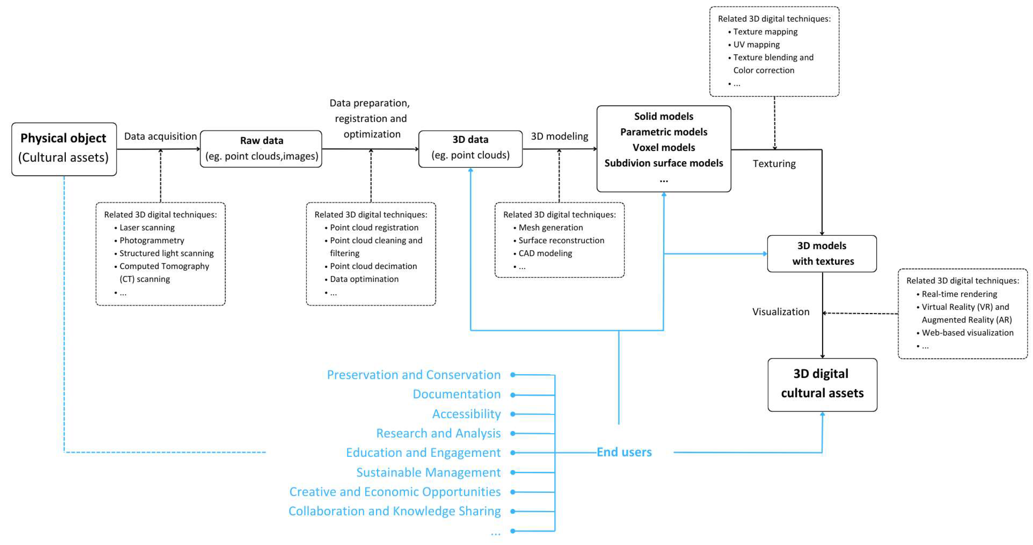
Figure 2.
The flow diagram for the literature search and evaluation for inclusion.
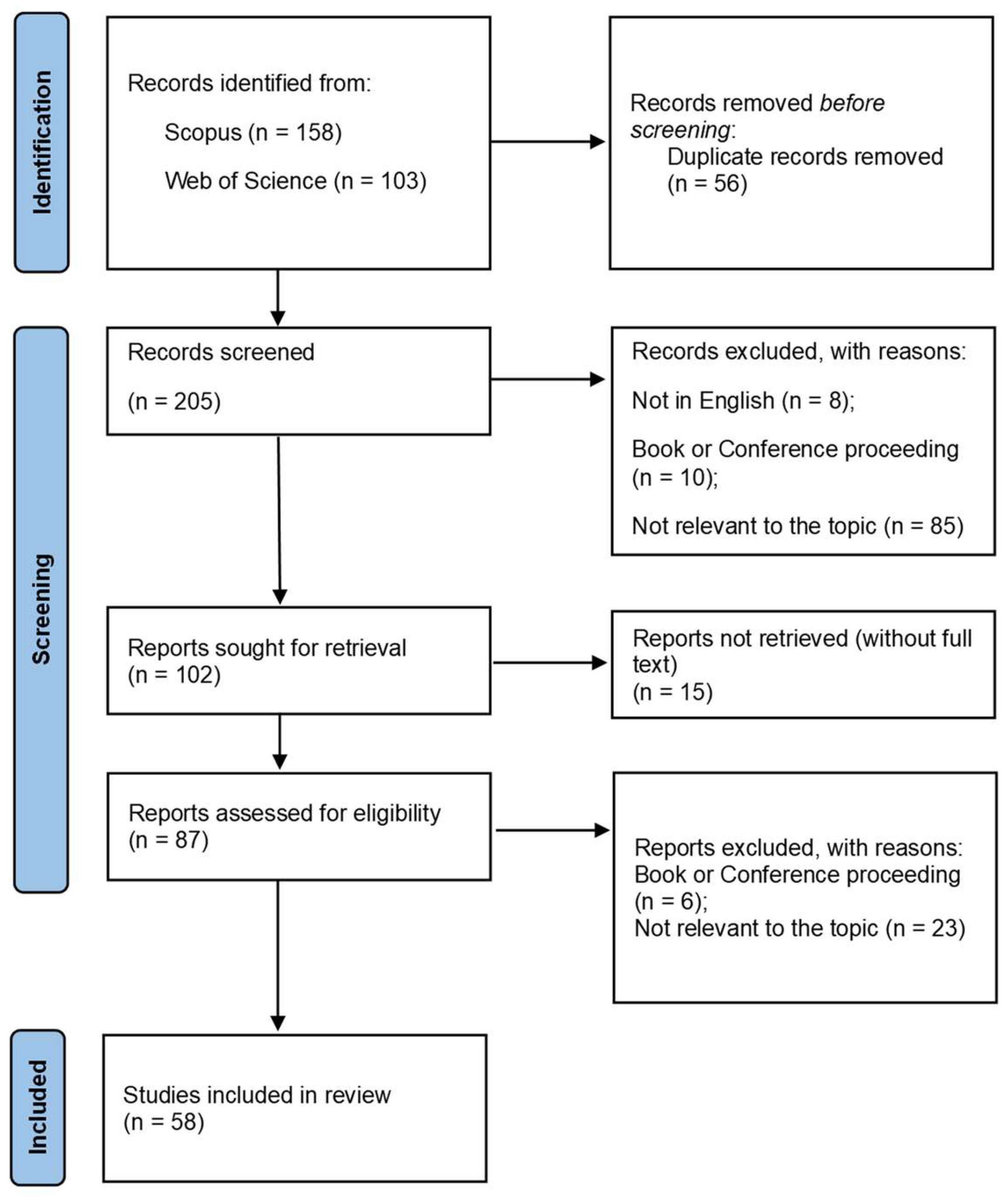
Figure 3.
Number and trend of publications that meet the selection criteria set.
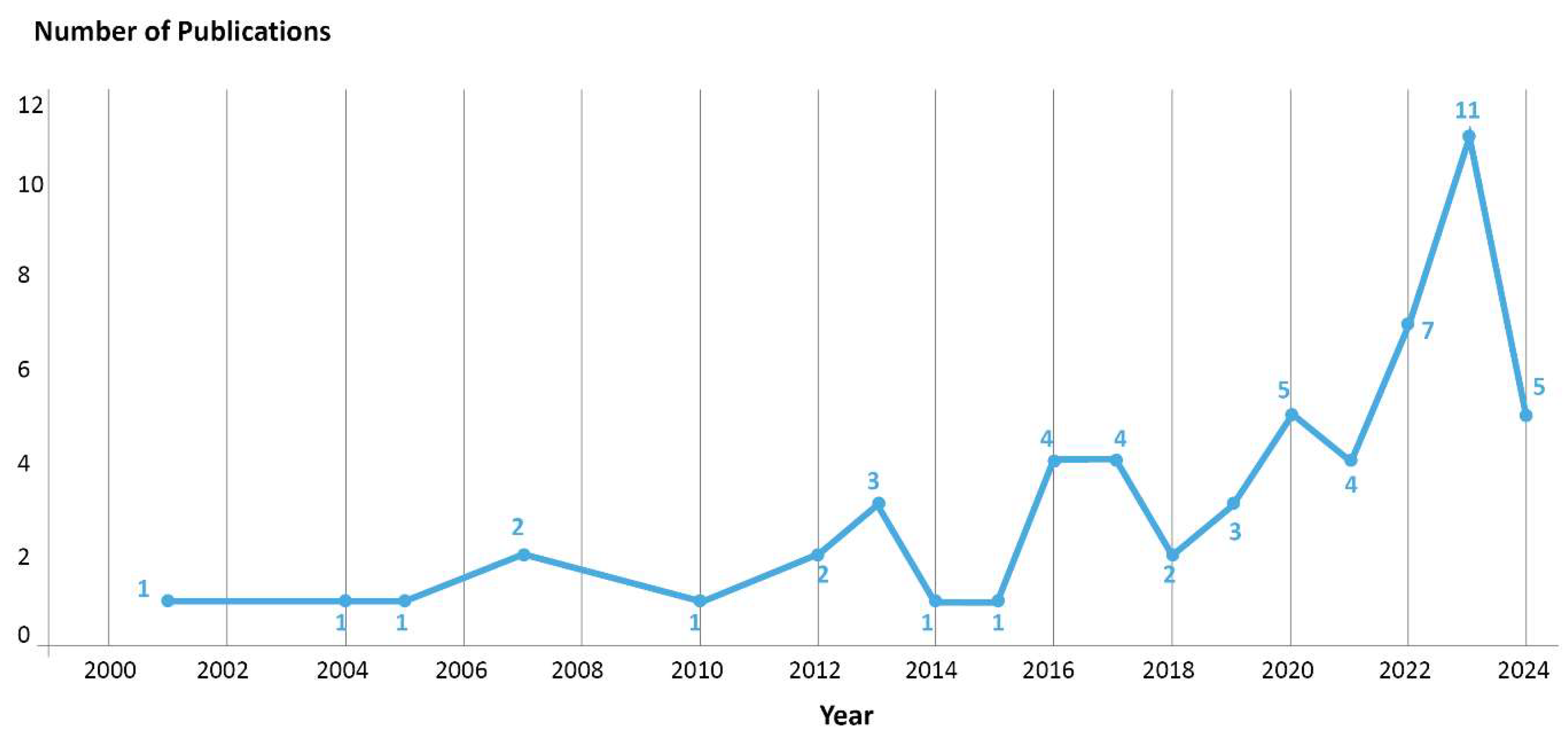
Figure 4.
The number of publications categorized by the country affiliations of researchers.
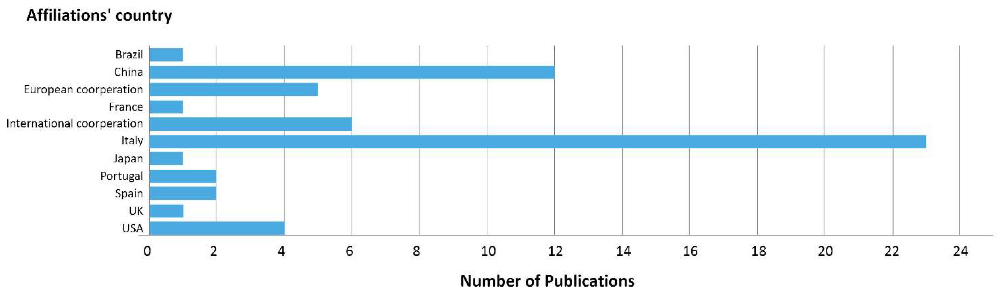
Figure 5.
Selected authors and their Co-authorships [41].
Figure 5.
Selected authors and their Co-authorships [41].

Figure 6.
Figure 6. The type and location of heritage objects studied.
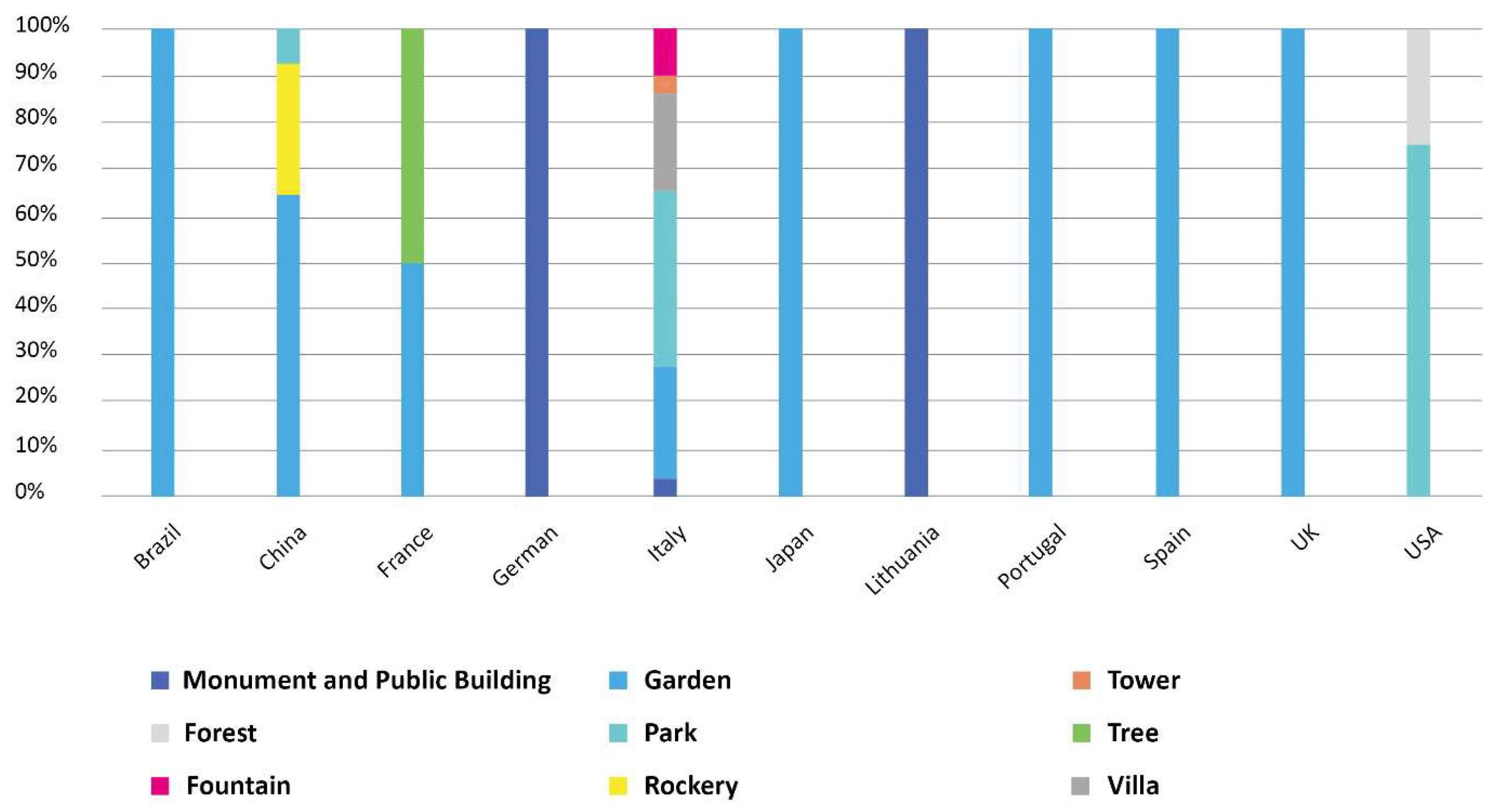
Figure 7.
3D digital techniques for data acquisition in selected publications and their annual variations.
Figure 7.
3D digital techniques for data acquisition in selected publications and their annual variations.
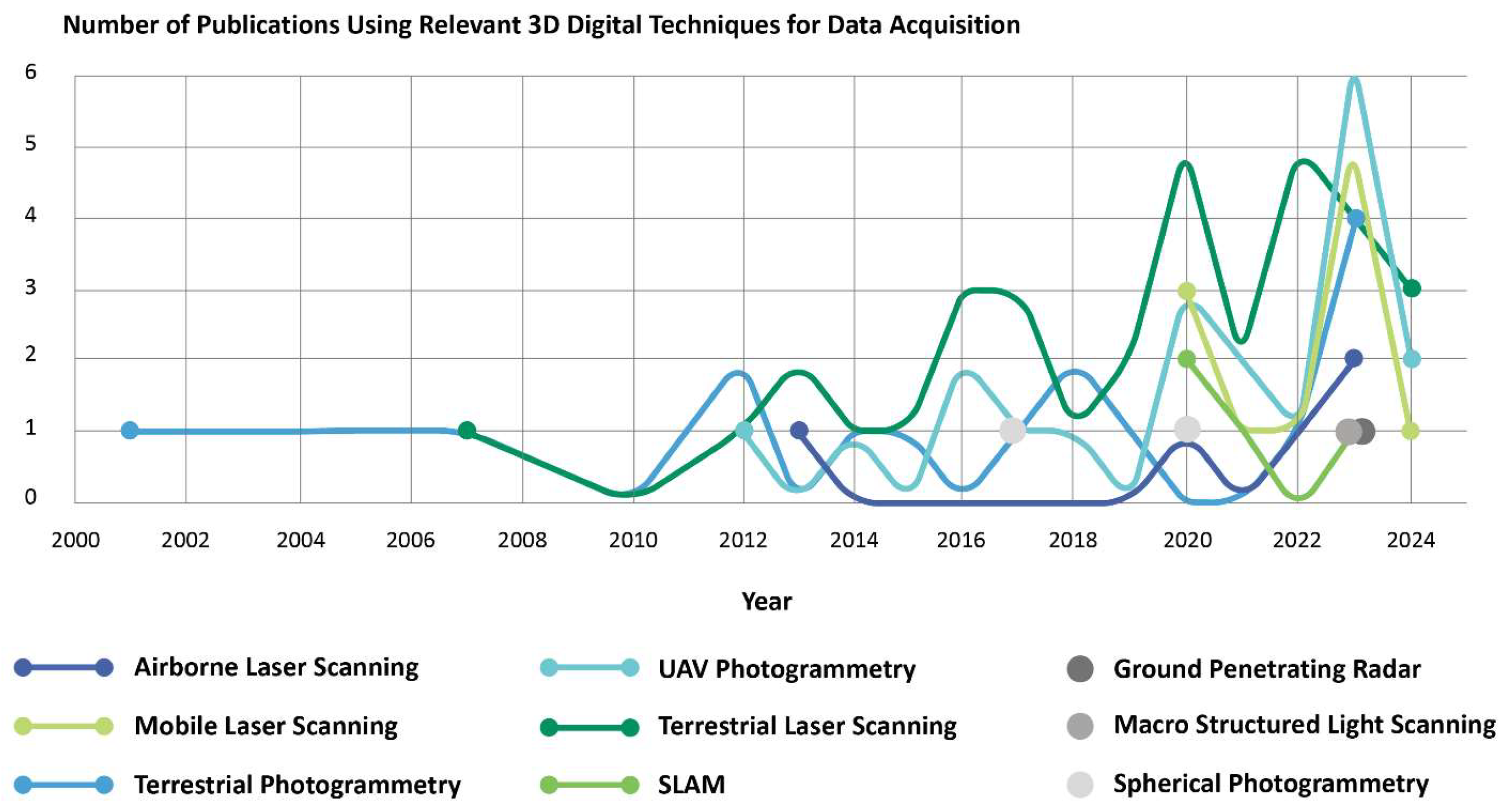
Figure 8.
Relationships among 3D digital techniques, heritage objects and end users.
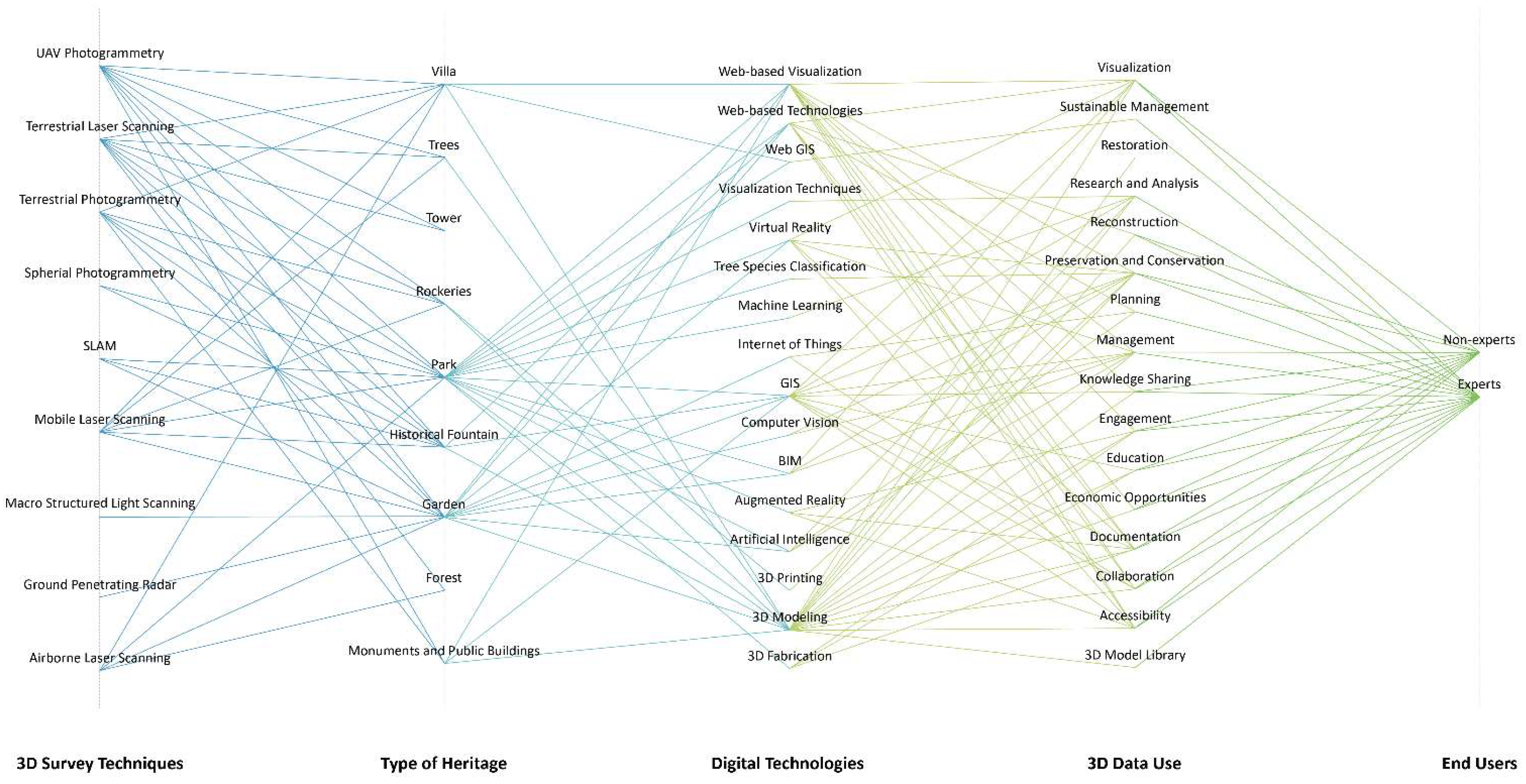
Figure 9.
Topographic reference network practice and visual representation, extended to cover the complete garden of the Villa Reale di Monza [43].
Figure 9.
Topographic reference network practice and visual representation, extended to cover the complete garden of the Villa Reale di Monza [43].
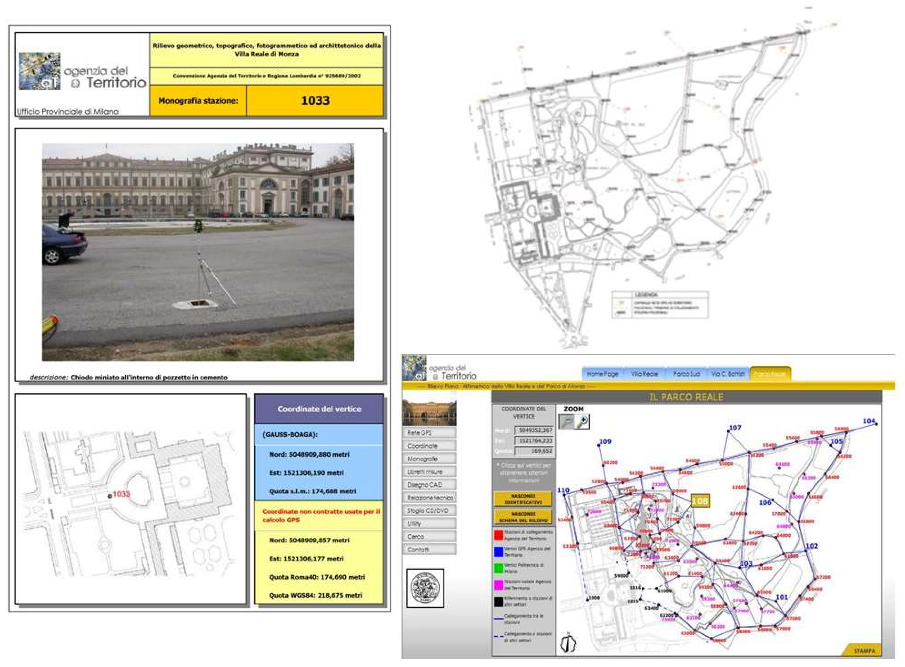
Figure 10.
Results of a 3D survey by laser scanner: on the top, garden-wide point cloud model orthogonal maps; below on the left the positions of the static scans; below on the right the Garden-wide point cloud model of Jianxin courtyard in Jingyi garden [44].
Figure 10.
Results of a 3D survey by laser scanner: on the top, garden-wide point cloud model orthogonal maps; below on the left the positions of the static scans; below on the right the Garden-wide point cloud model of Jianxin courtyard in Jingyi garden [44].
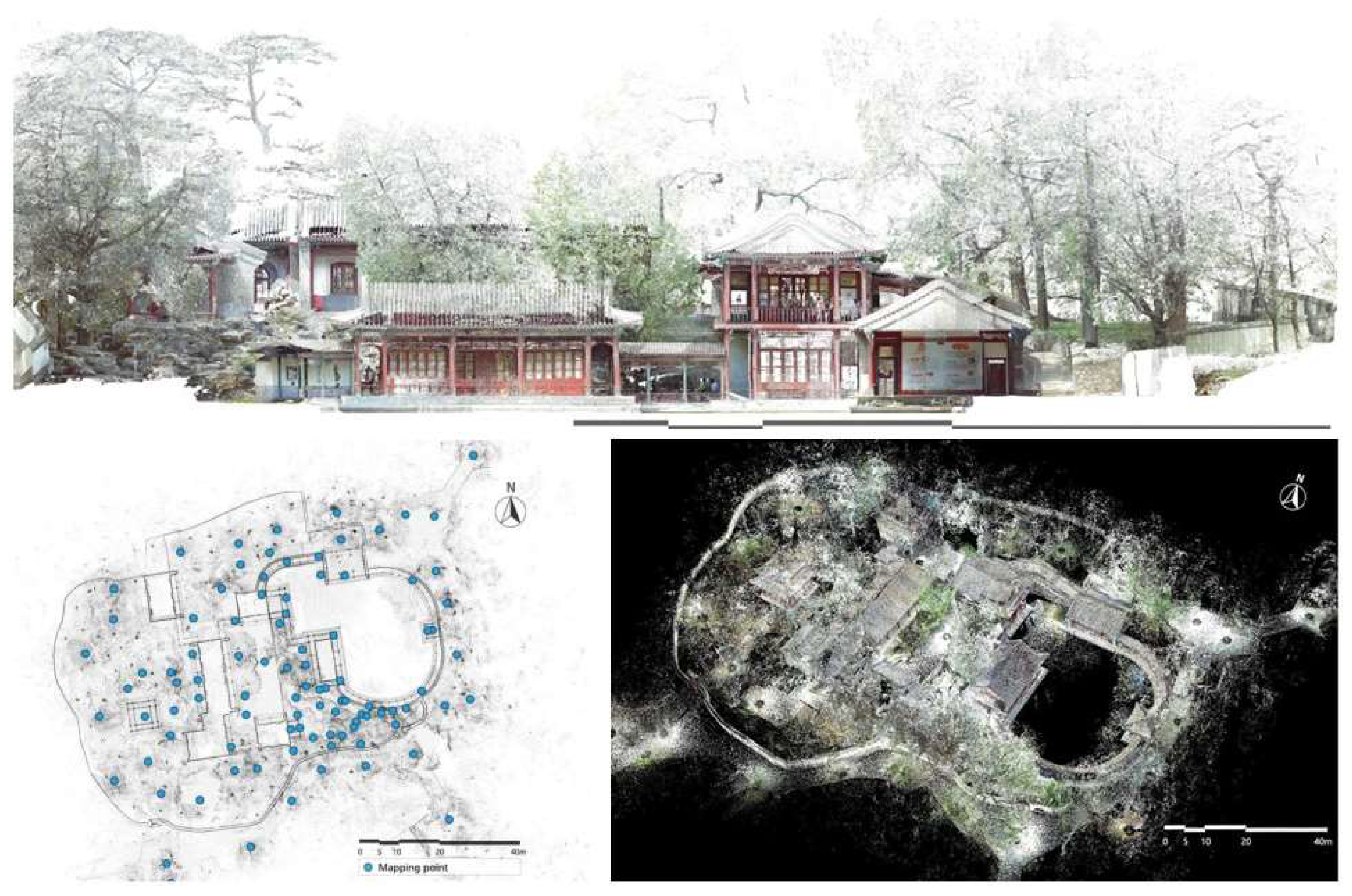
Figure 11.
An overview of the Huanxiu Shanzhuang (HXSZ) project. On the left, mixed survey techniques: the garden HXSZ in Suzhou, China, a: aerial view of the TLS point cloud model; b: aerial view of the UAVDP point cloud model; c: aerial view of the Terrestrial Digital Photogrammetry point cloud model of monolith A; d: aerial view of the TDP point cloud model of monolith B and the piled mountain; e: aerial view of the integrated point clouds from TLS, TDP and UAVDP. On the right, slicing of landscape elements in the backyard based on point cloud [45].
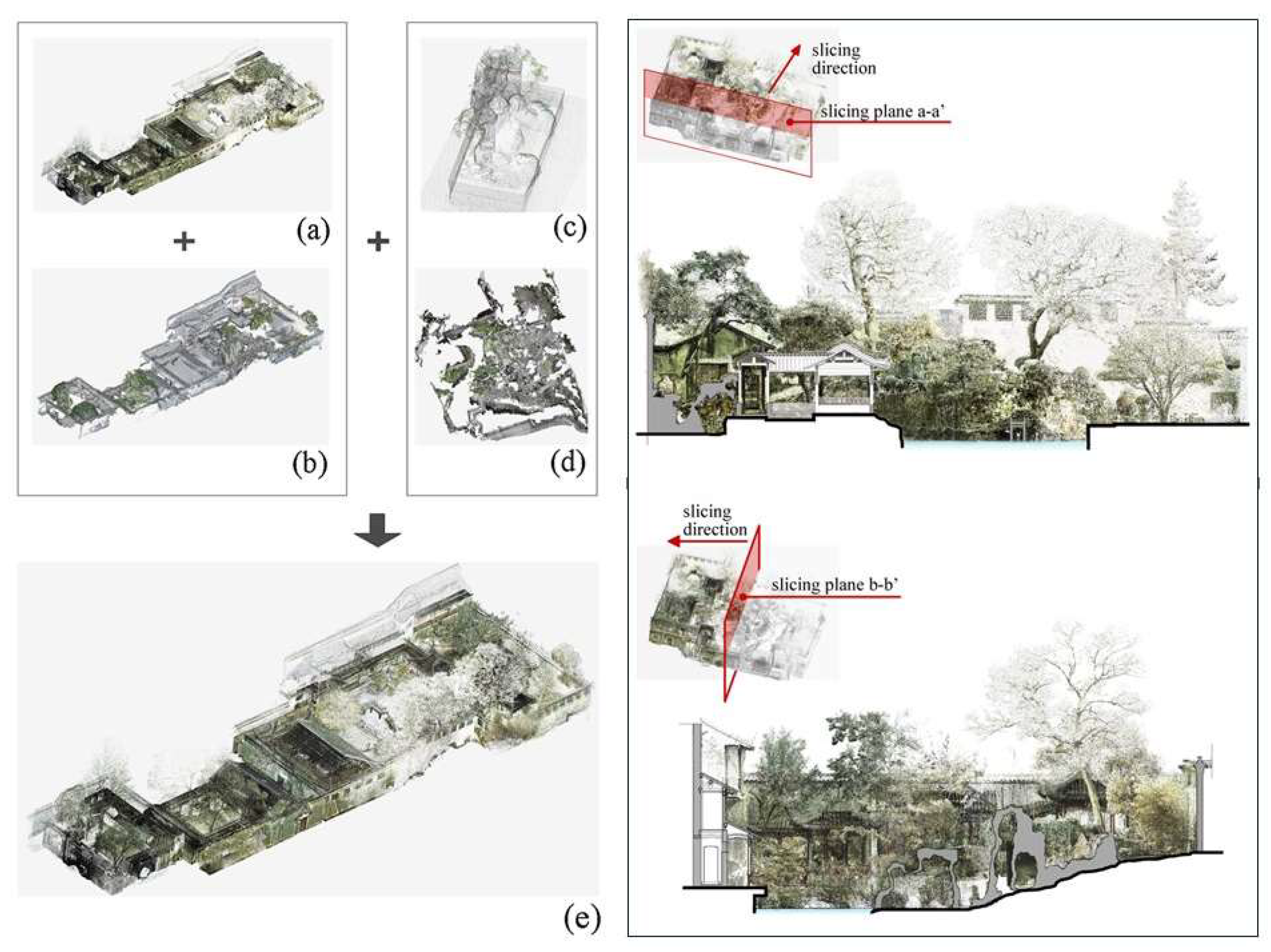
Figure 12.
3D models of the Giardino delle Camelie: on the left the mesh model of the whole survey area; on the right point cloud, detail of the upper retaining wall [46].
Figure 12.
3D models of the Giardino delle Camelie: on the left the mesh model of the whole survey area; on the right point cloud, detail of the upper retaining wall [46].
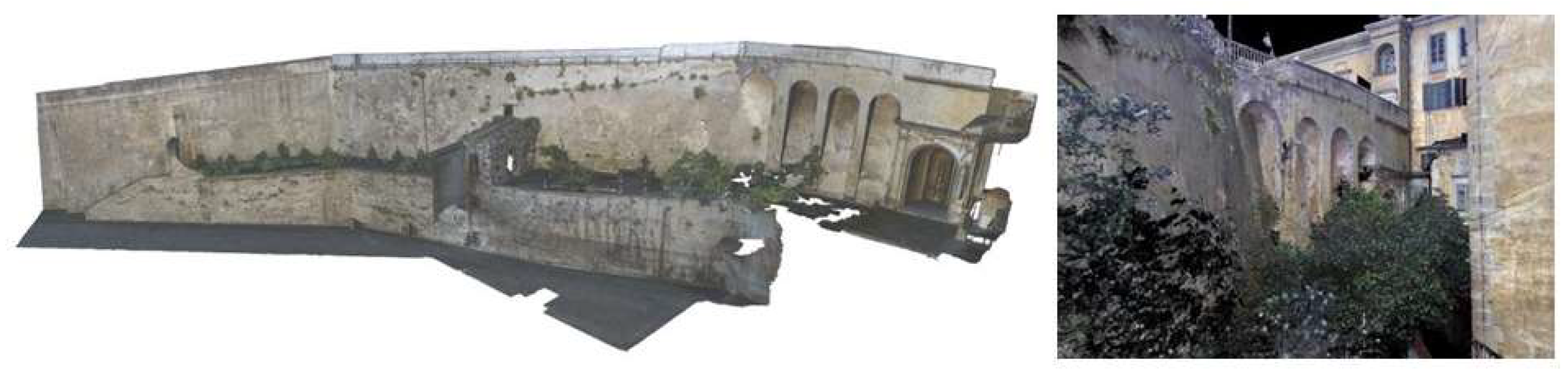
Figure 13.
Blueprints of the two obtained point clouds and the respective trajectories followed during the acquisition are highlighted. Heron Backpack survey (a), Ant3D survey (b), zoom of Heron Backpack blueprint (c), zoom of Ant3D blueprint (d). The red grid has a spacing of 10 x 10 m [12].
Figure 13.
Blueprints of the two obtained point clouds and the respective trajectories followed during the acquisition are highlighted. Heron Backpack survey (a), Ant3D survey (b), zoom of Heron Backpack blueprint (c), zoom of Ant3D blueprint (d). The red grid has a spacing of 10 x 10 m [12].
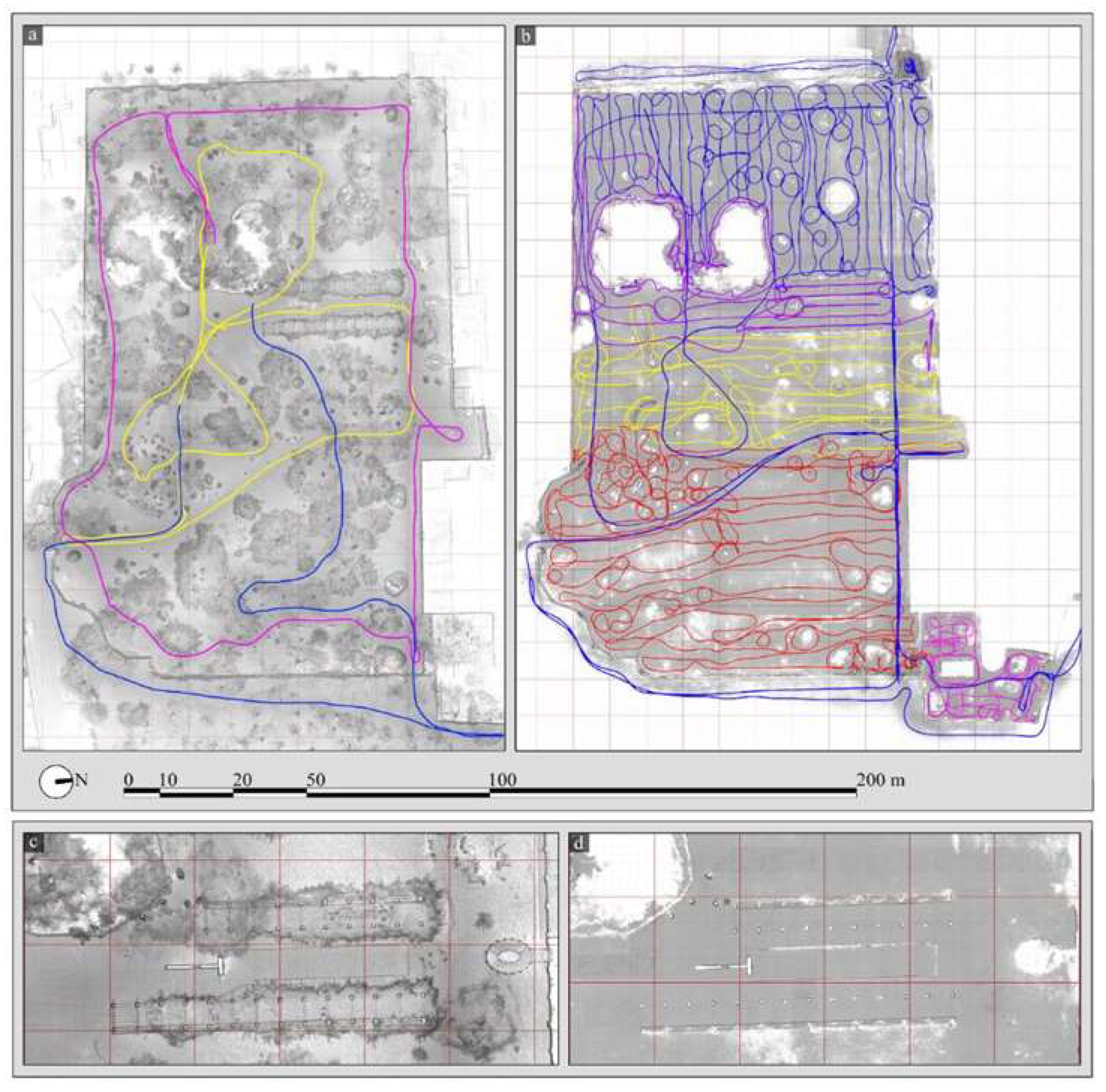
Figure 14.
An overview of Villa Burba Garden survey with MMS: on the left, the survey activities carried out with the Heron Backpack in the Villa Burba Garden; on the right, point clouds obtained for the survey carried out Heron Backpack [12].
Figure 14.
An overview of Villa Burba Garden survey with MMS: on the left, the survey activities carried out with the Heron Backpack in the Villa Burba Garden; on the right, point clouds obtained for the survey carried out Heron Backpack [12].
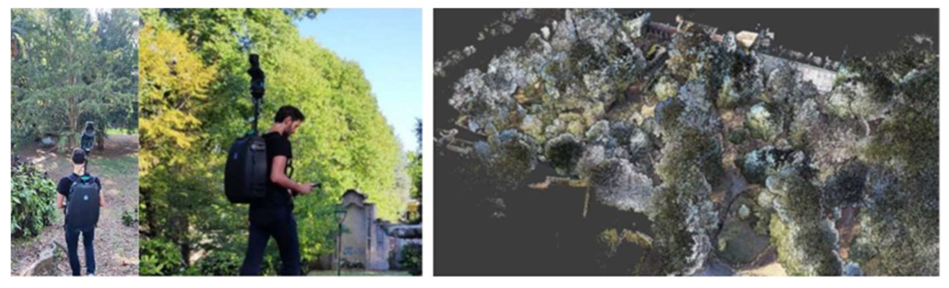
Figure 15.
Trees plan section at breast height extracted from the Heron Backpack point cloud (blue) and from the Ant3D point cloud in red [12].
Figure 15.
Trees plan section at breast height extracted from the Heron Backpack point cloud (blue) and from the Ant3D point cloud in red [12].
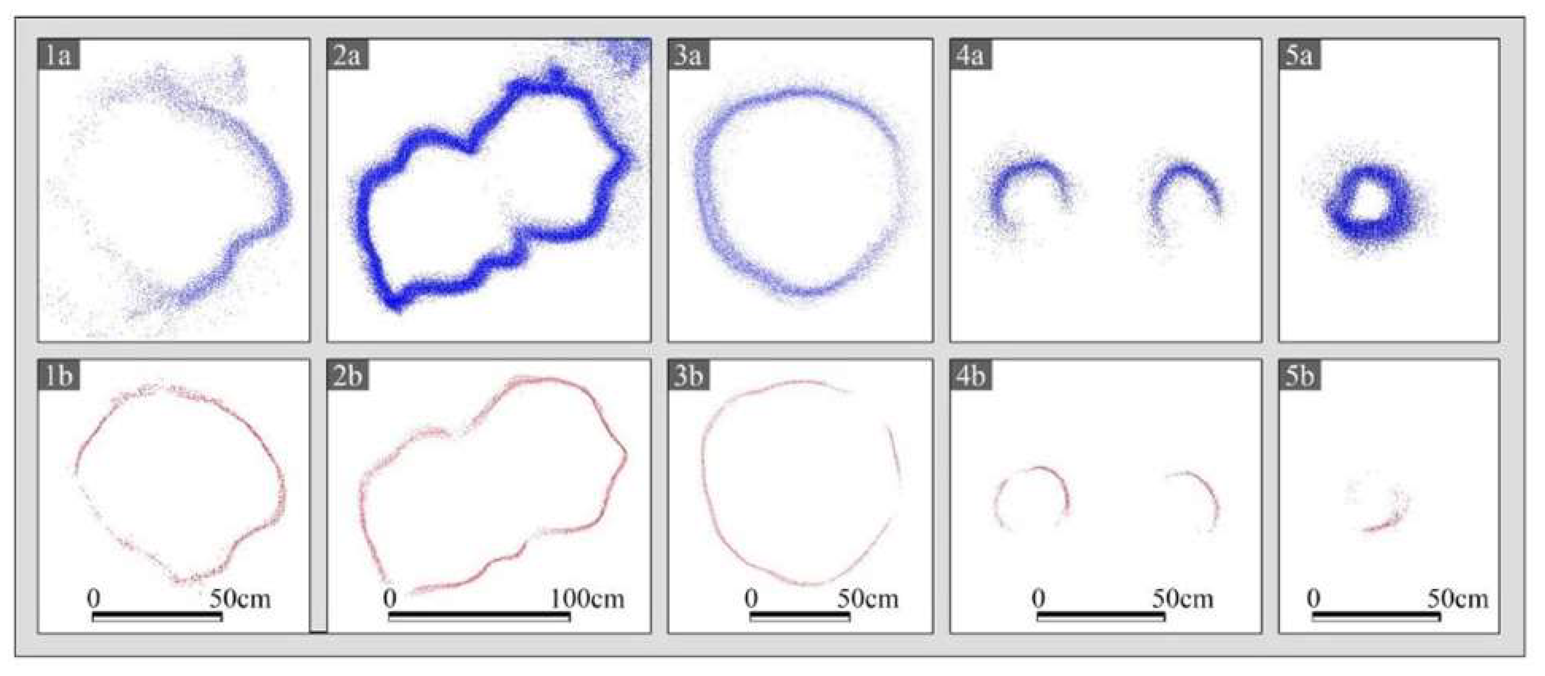
Figure 16.
Point clouds of the scope area obtained with the TLS (a) and MLS (b). Difference in density, detail accuracy, and level of noise is already noticeable from this top view [36].
Figure 16.
Point clouds of the scope area obtained with the TLS (a) and MLS (b). Difference in density, detail accuracy, and level of noise is already noticeable from this top view [36].
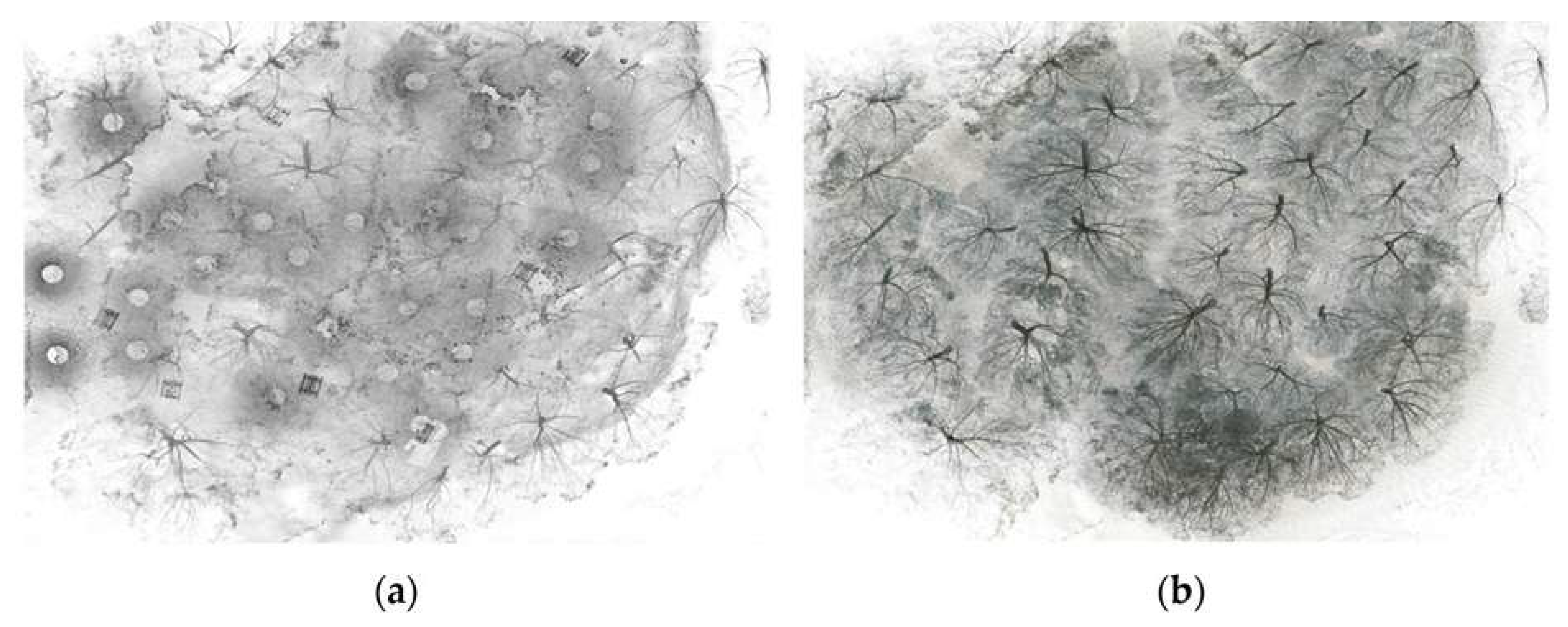
Figure 17.
Horizontal sections of the trees on the periphery area obtained by TLS and MLS. Although there is more noise, MLS is able to better define the sections in less scanning time [36].
Figure 17.
Horizontal sections of the trees on the periphery area obtained by TLS and MLS. Although there is more noise, MLS is able to better define the sections in less scanning time [36].
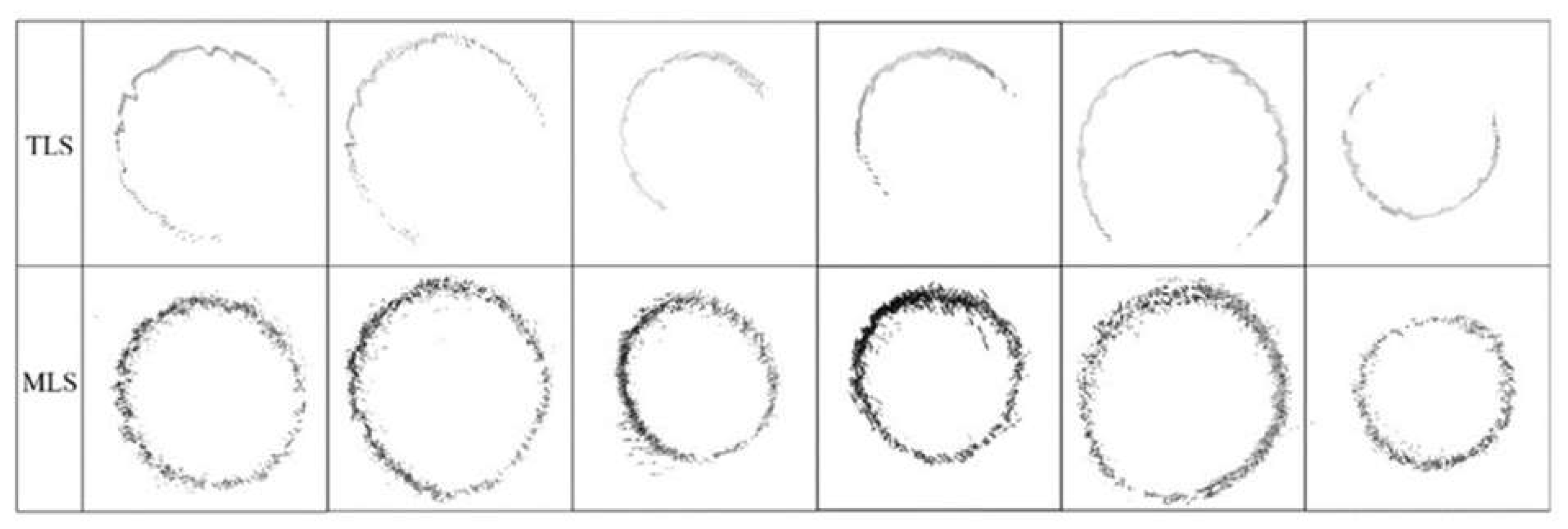
Figure 18.
An overview of the Naxos project. On the left: 22 trajectories of the Naxos Archaeological Park from the MMS survey. On the right: survey products in the Cintoo platform—a 360° image from the MMS trajectory, accessible from the 3D view (top); 3D mesh models built from point clouds in Cintoo (middle); and folders from the document repository available on the platform (bottom) [50,51].
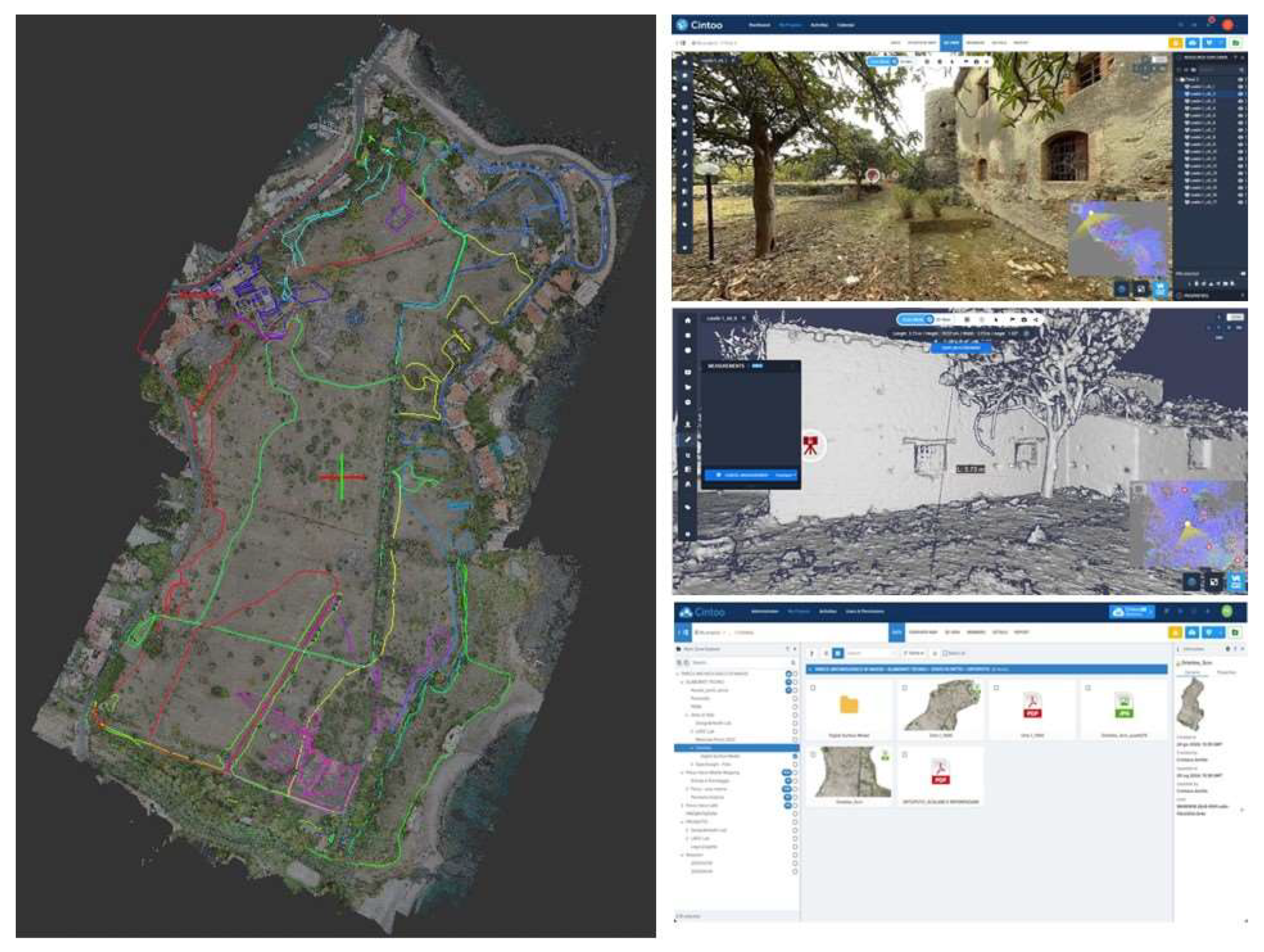
Figure 19.
Examples of trees modelling (from left to right): polygon model of black pine trunk, application to deciduous tree model and red pine trunk model [18].
Figure 19.
Examples of trees modelling (from left to right): polygon model of black pine trunk, application to deciduous tree model and red pine trunk model [18].

Figure 20.
A case study of Jichang Garden: (a) Master plan of the garden; (b) a typical scenery visualized with points data; (c) the voxels for buildings; (d) the voxels for vegetation [31].
Figure 20.
A case study of Jichang Garden: (a) Master plan of the garden; (b) a typical scenery visualized with points data; (c) the voxels for buildings; (d) the voxels for vegetation [31].
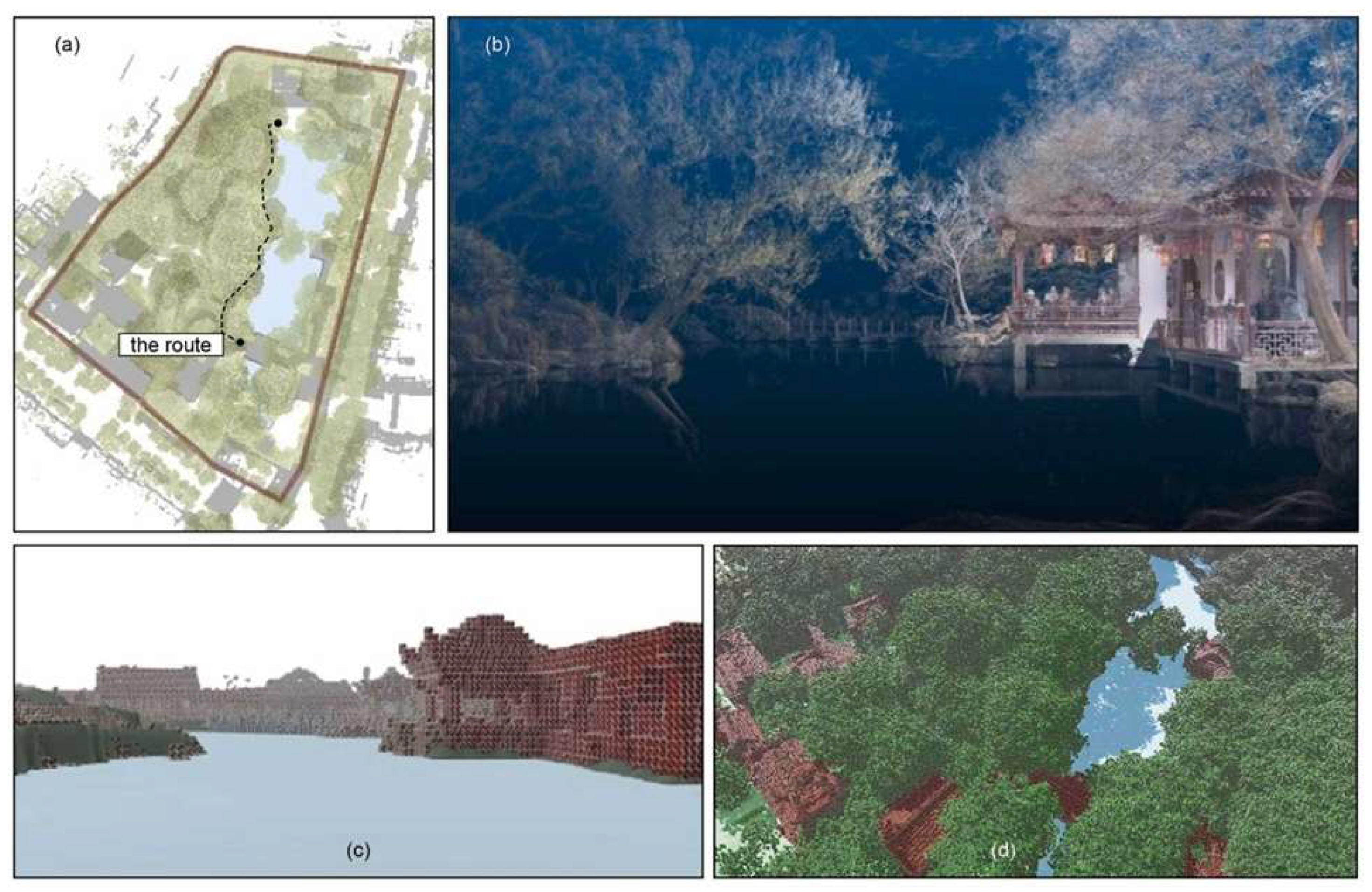
Figure 21.
An overview of JBT 3D webpage. On the top, front page of the JBT 3D StoryMap; On the bottom, examples of the VR360 views in JBT 3D, the ribbon shows part of the spots with Virtual Reality scenes: below on the left spot of Palácio dos Condes da Calheta, below on the right spot of Ceiba speciosa and other tree species [53].
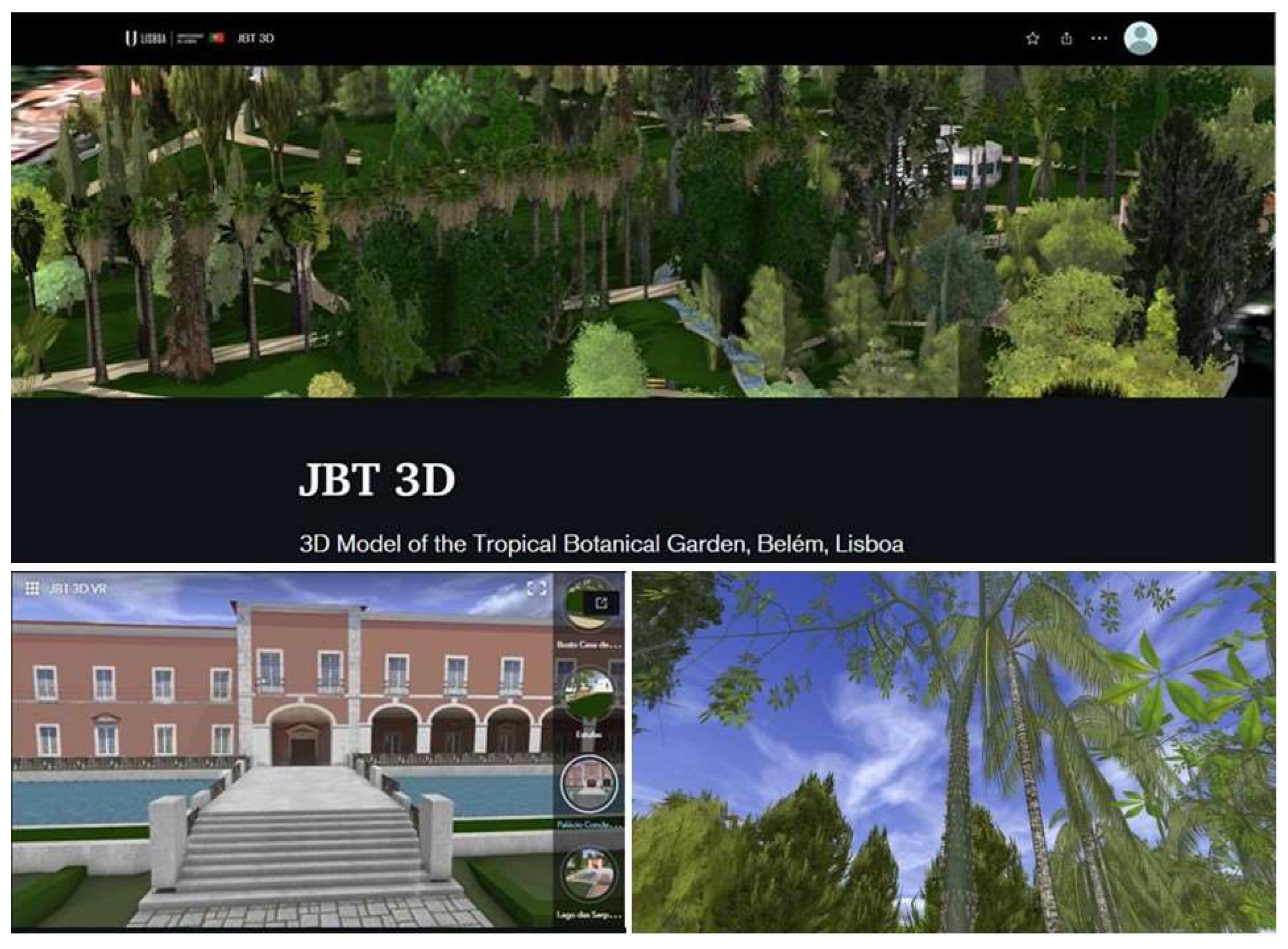

Table 1.
Key search terms.
| Adjectives for Heritage Construct |
Garden Construct |
3D Digital Technologies Construct |
|---|---|---|
| Historic | Garden | Point cloud |
| Historical | Park | 3D survey |
| Heritage | 3D modeling | |
| Archeological | 3D visualization |
Table 2.
Search results (08/01/2025).
| Adjectives for Heritage Construct (AND) |
Garden Construct (AND) |
3D Digital Technologies Construct (AND) |
Number of studies |
|---|---|---|---|
| Historic OR Historical OR Heritage OR Archeological |
Garden OR Park |
Point cloud OR 3D survey OR 3D modeling OR 3D visualization | 158 in Scopus |
| 103 in Web of Science |
Table 3.
Representative journals or conferences and proceedings [42].
Table 3.
Representative journals or conferences and proceedings [42].
| Source Title | Type | Covering the categories | h-index | Publisher | Number of Selected |
|---|---|---|---|---|---|
| International Archives of the Photogrammetry, Remote Sensing and Spatial Information Sciences - ISPRS Archives | Conferences and Proceedings | Geography; Planning and Development; Information Systems | 87 | International Society for Photogrammetry and Remote Sensing | 15 |
| ISPRS Annals of the Photogrammetry, Remote Sensing and Spatial Information Sciences | Conferences and Proceedings | Earth and Planetary Sciences; Environmental Science; Instrumentation | 53 | Copernicus GmbH | 3 |
| Heritage Science | Journals | Archeology (Q1); Archeology (arts and humanities) (Q1); Conservation (Q1); Chemistry (miscellaneous) (Q2); Computer Science Applications (Q2); Materials Science (miscellaneous) (Q2); Spectroscopy (Q2) | 35 | Springer Science + Business Media | 3 |
| Urban Forestry & Urban Greening | Journals | Ecology (Q1); Forestry (Q1); Soil Science (Q1) | 117 | Elsevier GmbH | 2 |
| Journal of Cultural Heritage | Journals | Anthropology (Q1); Archeology (arts and humanities) (Q1); Conservation (Q1); Economics, Econometrics and Finance (miscellaneous) (Q1); History (Q1); Chemistry (miscellaneous) (Q2); Computer Science Applications (Q2); Materials Science (miscellaneous) (Q2); Spectroscopy (Q2) | 84 | Elsevier Masson s.r.l. | 2 |
| Virtual Archaeology Review | Journals | Archeology (Q1); Archeology (arts and humanities) (Q1); Conservation (Q1); Computer Science Applications (Q3) | 17 | Universitat Politecnica de Valencia | 2 |
| PLoS ONE | Journals | Multidisciplinary (Q1) | 435 | Public Library of Science | 1 |
| AUTOMATION IN CONSTRUCTION | Journals | Building and Construction (Q1); Civil and Structural Engineering (Q1); Control and Systems Engineering (Q1) | 176 | Elsevier B.V. | 1 |
| Sustainability (Switzerland) | Journals | Geography, Planning and Development (Q1); Computer Networks and Communications (Q2); Energy Engineering and Power Technology (Q2); Environmental Science (miscellaneous) (Q2); Hardware and Architecture (Q2); Management, Monitoring, Policy and Law (Q2); Renewable Energy, Sustainability and the Environment (Q2) | 169 | Multidisciplinary Digital Publishing Institute (MDPI) | 1 |
| Landslides | Journals | Geotechnical Engineering and Engineering Geology (Q1) | 113 | Springer Verlag | 1 |
Disclaimer/Publisher’s Note: The statements, opinions and data contained in all publications are solely those of the individual author(s) and contributor(s) and not of MDPI and/or the editor(s). MDPI and/or the editor(s) disclaim responsibility for any injury to people or property resulting from any ideas, methods, instructions or products referred to in the content. |
© 2025 by the authors. Licensee MDPI, Basel, Switzerland. This article is an open access article distributed under the terms and conditions of the Creative Commons Attribution (CC BY) license (http://creativecommons.org/licenses/by/4.0/).
Copyright: This open access article is published under a Creative Commons CC BY 4.0 license, which permit the free download, distribution, and reuse, provided that the author and preprint are cited in any reuse.


